Embed Size (px)
Citation preview

WA-II-001
Old South Mountain Inn (South Mountain House)
Architectural Survey File
This is the architectural survey file for this MIHP record. The survey file is organized reverse-
chronological (that is, with the latest material on top). It contains all MIHP inventory forms, National
Register nomination forms, determinations of eligibility (DOE) forms, and accompanying documentation
such as photographs and maps.
Users should be aware that additional undigitized material about this property may be found in on-site
architectural reports, copies of HABS/HAER or other documentation, drawings, and the “vertical files” at
the MHT Library in Crownsville. The vertical files may include newspaper clippings, field notes, draft
versions of forms and architectural reports, photographs, maps, and drawings. Researchers who need a
thorough understanding of this property should plan to visit the MHT Library as part of their research
project; look at the MHT web site (mht.maryland.gov) for details about how to make an appointment.
All material is property of the Maryland Historical Trust.
Last Updated: 03-21-2013

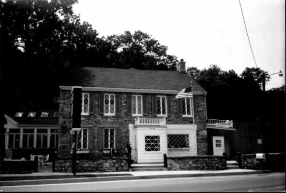
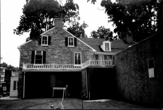
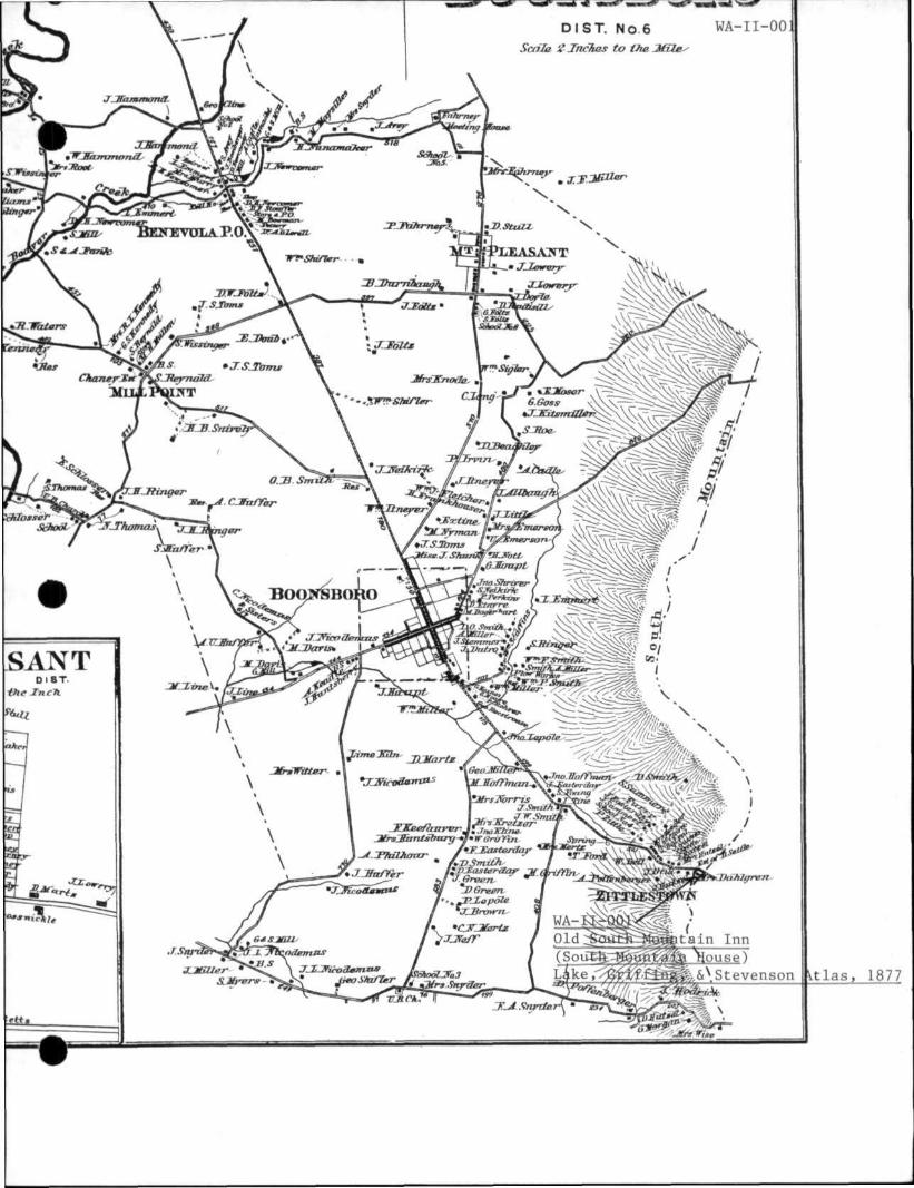
WA-ll-001 18th & 19th centuries Old South Mountain Inn (Mountain House) Alt. US 40 Turner's Gap (Boonsboro)
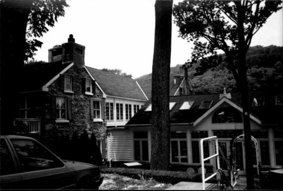
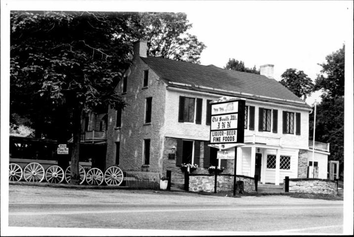
Located on the south side of Alt. US 40 on the top of South Mountain, the
Old South Mountain Inn is a two-story five-bay stone house with several rear
wings and a glass-enclosed side addition. The main block of the house has a
flush chimney at each gable end. The two west bays of the first floor of the front
(north) facade have been replaced by one large frame-filled opening with a wide
picture window set in it. The center door has been covered by a porch with
square posts and a short balustrade above. This porch is now enclosed, with
the entrance to the east side and a window on the north side.
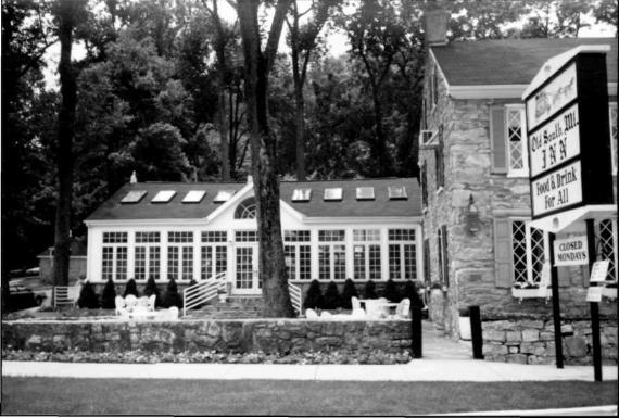
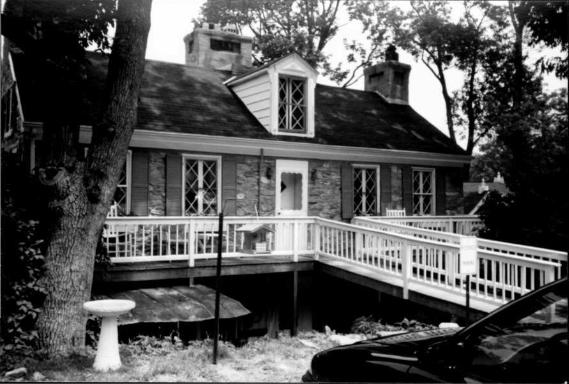
A frame wing extends south from the main block, with another stone
building joined to that, parallel to the main block. This stone section has a single
dormer on the south side of the gable roof, and also has flush chimneys at the
ends. This section is also five bays wide, and both the first and second floors
have a central entrance. The second floor entrance opens onto a deck, which
leads to the parking lot, which is at about the second floor level.
The windows of both the stone sections have been replaced with
diamond-pane casement windows.
Extending eastward from the frame section is a more modern frame
section almost entirely composed of windows and French doors.
To the east of the building is a small stone and brick outbuilding with a
pyramidal hip roof topped by a finial. The first two or three feet of this structure
WA-ll-001
is built of stone, the remaining three or four feet is 1/6 common bond brick.
Above the entrance door is a hip-roofed hood with elaborate carved wooden
brackets. The point of the hip roof of this hood also holds a finial.
Part of the building may date to the 18th century, but this has not been
ascertained. The building was used as an Inn as early as the early 19th century,
and notable visitors included Abraham Lincoln, Daniel Webster, and Henry Clay.
During the Civil War, the building was used as headquarters during the Battle of
South Mountain by Confederate General D.H. Hill. . „V,
In 1876, the South Mountain House was purchased by Madeleine V.
Dahlgren, widow of Admiral John A. Dahlgren, who invented the Dahlgren gun.
She converted the inn to a private residence and constructed the private chapel
across the road.
The building has again been used as a restaurant since 1973.

ADDENDUM
WA-ll-001 Old South Mountain Inn Turner's Gap Boonsboro, MD
ITEM 8: Statement of Significance and History
This additional information is being supplied as part of the South Mountain Battlefield Survey Project, February 1998. The Old South Moimtain Inn, known historically as the Mountain House, is located within the survey area and was unpacted by the Battle of South Mountain which occurred on September 14, 1862. The inn was Confederate General D.H. Hill's headquarters during the battle, and so was the command center for the action that occurred at Tumer's and Fox's Gaps, as rebels tenaciously defended the passes over South Mountain.
The Old National Pike which passes in front of the iim was of strategic hnportance to both the Confederate and Union armies because it provided access to one of the few crossing places through the mountains and because of the superior quality of its surface which could accommodate large numbers of marching men, horses and supply trains. Tumer's Gap at the summit where the inn is located, became the focal point for the fight and was the main objective for the Union army as it attempted to follow the Confederates into the Hagerstown Valley and capture the divided rebel army.
The discovery on September 13, 1862 of General Robert E. Lee's Special Order #191, the Lost Order, in a field near Frederick where the Confederates had camped precipitated the march of the Army of the Potomac toward South Mountain along the Old National Pike. The tumpike crossed the mountain running west toward the center of Lee's divided army. Had Union commander, George B. McClellan approached the mountain with speed, as he had indicated he would to President Lincoln, the Battle of South Mountain might have ended differently.'
The Special Order #191 detailed General Lee's deployment of the Army of Northern Virginia in September 1862. In addition to the siege of Harper's Ferry by three divisions under Stonewall Jackson from the west and two divisions under Lafayette McLaws from the northeast, the orders described the location of Robert E. Lee and James Longstreet with two divisions at Hagerstown and D.H.Hill's division, alone at Boonsboro, just below Tumer's Gap. With the knowledge of the divided nature of Lee's army on the west side of South Mountain, and the small defensive line at the pass, McClellan felt confident in his arm/s ability to catch Lee's forces in this vulnerable position. However, McClellan's infamous cautiousness and over-estimation of the size of his opponent, delayed the movement of the Army of the Potomac for half a day. The result of his slow approach to the pass at South Mountain was to give the Confederate defenders time to reinforce their tenuous position and begin pulling their divided army together again at Sharpsburg.
'Stephen W. Sears, "Fire on the Mountain," Blue and Gray, December-January, 1986-87, p. 11
WA-ll-001
D.H.Hill's respcHise to the deployment of the Union troops as he viewed them from his headquarters at the Mountain House on the crest of die pass, would set up the battles at Fox's and Turner's Gaps. Major General Hill stated, "Should the truth be known, the batde of South Mountain, as far as my division was concerned, will be regarded as one of the most remarkable and creditable of die war....the division numbered less than 5,000 men the morning of September 14, and we had five roads to guard, extending over a space of as many miles."^
^Official Records, Vol. XIX, Part I, p. 1021.
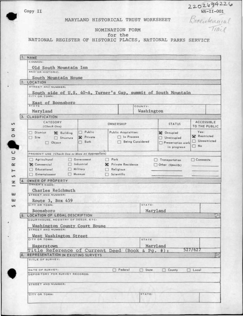
Copy II
MARYLAND HISTORICAL TRUST WORKSHEET
NOMINATION FORM
for the NATIONAL REGISTER OF HISTORIC PLACES, NATIONAL PARKS SERVICE
WA-ll-001
NAME COMMON :
Old South Mountain Inn A N D / O R H I S T O R I C ;
South Mountain House
S T R E E T ANC N U M B E R :
South s i de of U.S. 40-A. T u r n e r ' s Gap. summit o f South Mountain CITY OR TOWN;
East o f Boonsboro STA TE C O U N T Y ;
Maryland Washington CLASSIFICATION
^ ^ • ^ ^ ' ^ O R Y OWNERSHIP STATUS A C C E S S I B L E (Check One) TO T H E P U B L I C
Dis t r ic t Building Public Public Acquis i t ion: Occupied
Site Structure Pn^afe 1" Process Unoccupied Restr icted
Object Both Being Considered p „ „ , ^ < „ i „ „ ^ ^ . ^ Unrestricted
in progress
P R E S E N T USE (Check One or More as Appropriate)
Agricultural Government Pork Tronsportation • Comments
Commercial Industriol Pr ivate Residence Other fSnerltv)
Educational Mi l i tary Rel ia ious
Entertainment Museum Scienti f ic
OWNER OF PROPERTY OWNER'S NAME:
Char les Reichmuth S T R E E T AND N U M B E R :
Route 3, Box 459 C I T Y OR TOWN: S T A T E :
Boonsboro Maryland LOCATION OF LEGAL DESCRIPTION C O U R T H O U S E . REGISTRY O F D E E D S . E T C ;
Washington Countv Court House S T R E E T AND NUMBER:
West Washington S t ree t C I T Y OR TOWN: S T A T E
Hagerstown Maryland T i t l e R e f e r e n c e o f C u r r e n t Deed (Book & P g . # ) : 527/627
REPRESENTATION IN EXISTING SURVEYS T I T L E O F S U R V E Y :
D A T E O F S U R V E Y : Q Federal • State • County • Local
D E P O S I T O R Y FOR SURVEY RECORDS:
S T R E E T AND N U M B E R :
C I T Y OR TOWN: I S T A T E : 1
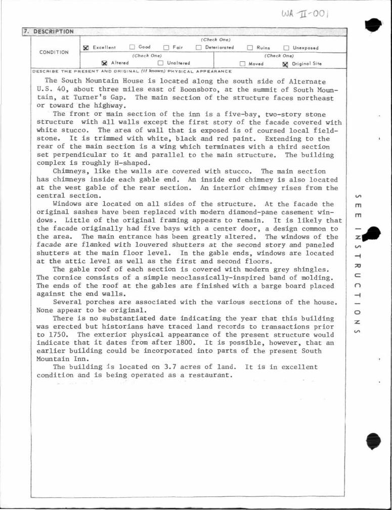
WA-ll-001
7 . D E S C R I P T I O N
C O N D I T I O N
(Check One)
g ] Exce l len t D Good D Po'"' • Deteriorated • Ruins C2 Unexposed
(Check One)
l a Al tered Q Unoltered
(Check One)
[ 1 Moved W Original Site
OESCFHBE T H E P R E S E N T AND O R I G I N A L (If known) P H Y S I C A L A P P E A R A N C E
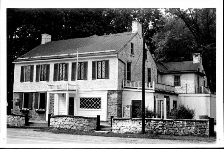
The South Mountain House is located along the south side of Alternate U.S. 40, about three miles east of Boonsboro, at the summit of South Mountain, at Turner's Gap. The main section of the structure faces northeast or toward the highway.
The front or main section of the inn is a five-bay, two-story stone structure with all walls except the first story of the facade covered with white stucco. The area of wall that is exposed is of coursed local field-stone. It is trimmed with white, black and red paint. Extending to the rear of the main section is a wing which terminates with a third section set perpendicular to it and parallel to the main structure. The building complex is roughly H-shaped.
Chimneys, like the walls are covered with stucco. The main section has chimneys inside each gable end. An inside end chimney is also located at the west gable of the rear section. An interior chimney rises from the central section.
Windows are located on all sides of the structure. At the facade the original sashes have been replaced with modern diamond-pane casement windows. Little of the original framing appears to remain. It is likely that the facade originally had five bays with a center door, a design common to the area. The main entrance has been greatly altered. The windows of the facade are flanked with louvered shutters at the second story and paneled shutters at the main floor level. In the gable ends, windows are located at the attic level as well as the first and second floors.
The gable roof of each section is covered with modem grey shingles. The cornice consists of a simple neoclassically-inspired band of molding. The ends of the roof at the gables are finished with a barge board placed against the end walls.
Several porches are associated with the various sections of the house. None appear to be original.
There is no substantiated date indicating the year that this building was erected but historians have traced land records to transactions prior to 1750. The exterior physical appearance of the present structure would indicate that it dates from after 1800. It is possible, however, that an earlier building could be incorporated into parts of the present South Mountain Inn.
The building is located on 3.7 acres of land. It is in excellent condition and is being operated as a restaurant.

WA-ll-001
{e. SIGNIFICANCE
S T A T E M E N T O F S I S N I F I C A N C E
P E R I O D (Check One or More as Approprimte)
Pre-Columbian • 16th Century
15th Century • I7 th Century
18th Century
19th Century
I 20th Century
S P E C I F I C D A T E I S ) (1/ Applicable and Known)
AREAS OF SIGNIFICANCE (Check One or More as Appropriate)
Abor iginol
I I Prehistoric
• Histor ic
Agriculture
Architecture
Art
Commerce
Communi cot ions
Conservat ion
Educoti on
Engineering
Industry
Invention
Landscape
Architecture
Literoture
Mi l i tary
Music
Po l i t i ca l
R e l i g i o n / P h i . .
losophy
Science
Sculpture
Socia l /Human*
itarlon
Theoter
Transportation
Urban Plonning
Other (Specify)
Significant as an
early inn and stage stop on the National Road.
portions of the buildine could date from the 18th century
Although its architecture has been greatly altered, the South Mountain Inn is rich in historical significance. According to a publication on the history of South Mountain House, Robert Turner, for whom Turner's Gap was named, purchased a 575-acre tract from Arthur Nelson in 1750. The property was called "Nelson's Folly.-*-" In 1769, the land was apparently transferred to Jacob Young, an innkeeper.
It is possible then, that an inn was in operation at the summit of South Mountain by the 1770's if not earlier. Detailed physicial examination of the structure would be necessary to determine whether any parts of an 18th century building remain.
It is apparent from historical data that the South Mountain Inn did a brisk business during the first half of the 19th century when the National Road took many travelers by its door. Abraham Lincoln is said to have spent the night at the inn in 1840 and other distinguished visitors are reported to have been Daniel Webster and Henry Clay.
During the Civil War General D. H. Hill, commander of the rear guard of Lee's Confederate forces, established headquarters at the inn during the Battle of South Mountain.
In 1876, the South Mountain House was purchased by Madeleine V. Dahl-gren, widow of Admiral John A. Dahlgren, who invented the Dahlgren gun. She converted the inn to a private residence and constructued the private chapel across the road.
The property was acquired by the present owner in July, 1973.
-̂ Lemoin Cree, "A Brief History of South Mountain House," The Valley Register, Inc., Middletown, Md., 1963, p. 4, as noted from the Land Office, Annapolis, Md., Liber B, Folio 336. 2lbid.
WA-ll-001
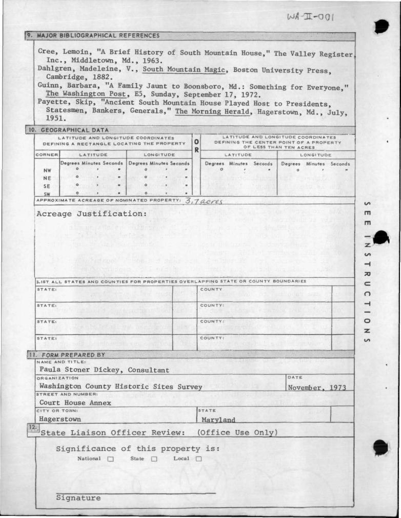
MAJOR B 1 B L I 0 G R A P H K : A L R|FERgNCES
Cree, Lemoin, "A Brief History of South Mountain House," The Valley Register Inc., Middletown, Md., 1963.
Dahlgren, Madeleine, V., South Mountain Magic, Boston University Press Cambridge, 1882.
Guinn, Barbara, "A Family Jaunt to Boonsboro, Md,: Something for Everyone," The Washington Post, E5, Sunday, September 17, 1972.
Payette, Skip, "Ancient South Mountain House Played Host to Presidents, Statesmen, Bankers, Generals," The Morning Herald, Hagerstown, Md.. Julv 1951.
10. GEOGRAPHICAL DATA L A T I T U D E A N D L O N G I T U D E C O O R D I N A T E S
D E F I N I N G A R E C T A N G L E L O C A T I N G T H E P R O P E R T Y
C O R N E R
NW
NE
SE
L A T I T U D E
Degrees Minutes Seconds
L O N G I T U D E
Degrees Minutes Seconds
L A T I T U D E AND L O N G I T U D E C O O R D I N A T E S D E F I N I N G T H E C E N T E R P O I N T O F A P R O P E R T Y
OF LESS T H A N T E N ACRES
L A T I T U D E
Degrees Minutes Seconds o
L O N G I T U D E
Degrees Minutes Seconds
A P P R O X I M A T E A C R E A G E O F N O M I N A T E D P R O P E R T Y 3.7 acres
;Acreage J u s t i f i c a t i o n :
L I S T A L L S T A T E S AND C O U N T I E S FOR P R O P E R T I E S O V E R L A P P I N G S T A T E OR C O U N T Y BOUNDARIES
S T A T E :
S T A T E :
S T A T E :
S T A T E :
C O U N T Y
C O U N T Y :
C O U N T Y :
C O U N T Y :
FORM PREPARED BY N A M E AND T l T L E :
Paula Stoner D i c k e y , Consu l tan t ORG ANI Z A T I O N
Washington County H i s t o r i c S i t es Survey
D A T E
November. 1973 S T R E E T AND N U M B E R :
Court House Annex C I T Y OR TOWN:
Hagerstown S T A T E
Maryland
^ S t a t e L i a i s o n O f f i c e r R e v i e w : ( O f f i c e Use O n l y )
S i g n i f i c a n c e o f t h i s p r o p e r t y i s : National • State • Local •
S i g n a t u r e
WA-II-OO1