Embed Size (px)
Citation preview
Fie
ld T
rip
Gu
ide B
oo
k -
D0
5
Florence - ItalyAugust 20-28, 2004 During-Congress D05
32nd INTERNATIONAL GEOLOGICAL CONGRESS
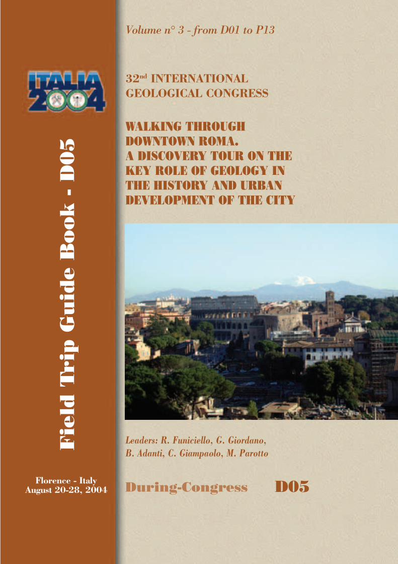
WALKING THROUGH DOWNTOWN ROMA. A DISCOVERY TOUR ON THE KEY ROLE OF GEOLOGY IN THE HISTORY AND URBAN DEVELOPMENT OF THE CITY
Leaders: R. Funiciello, G. Giordano, B. Adanti, C. Giampaolo, M. Parotto
Volume n° 3 - from D01 to P13
D05_copertina_R_OK C 21-05-2004, 15:56:15
The scientific content of this guide is under the total responsibility of the Authors
Published by: APAT – Italian Agency for the Environmental Protection and Technical Services - Via Vitaliano Brancati, 48 - 00144 Roma - Italy
Series Editors:Luca Guerrieri, Irene Rischia and Leonello Serva (APAT, Roma)
English Desk-copy Editors:Paul Mazza (Università di Firenze), Jessica Ann Thonn (Università di Firenze), Nathalie Marléne Adams (Università di Firenze), Miriam Friedman (Università di Firenze), Kate Eadie (Freelance indipendent professional)
Field Trip Committee: Leonello Serva (APAT, Roma), Alessandro Michetti (Università dell’Insubria, Como), Giulio Pavia (Università di Torino), Raffaele Pignone (Servizio Geologico Regione Emilia-Romagna, Bologna) and Riccardo Polino (CNR, Torino)
Acknowledgments:The 32nd IGC Organizing Committee is grateful to Roberto Pompili and Elisa Brustia (APAT, Roma) for their collaboration in editing.
Graphic project:Full snc - Firenze
Layout and press:Lito Terrazzi srl - Firenze
D05_copertina_R_OK D 21-05-2004, 15:54:51

Florence - ItalyAugust 20-28, 2004
During-Congress
D05
32nd INTERNATIONAL GEOLOGICAL CONGRESS
WALKING THROUGH DOWNTOWNROMA. A DISCOVERY TOUR ON THE KEY ROLE OF GEOLOGY IN THE HISTORY AND URBAN DEVELOPMENT OF THE CITY
Volume n° 3 - from D01 to P13
AUTHORS:R. Funiciello, G. Giordano, B. Adanti, C. Giampaolo, M. Parotto (Dipartimento Scienze Geologiche, Università Roma TRE - Italy)
D05_R_OK A 21-05-2004, 15:59:16

Front Cover:A view of Colosseo from the Vittoriano. In the background, the Colli Albani volcano dominating the city of Roma.
D05_R_OK B 21-05-2004, 15:59:18
WALKING THROUGH DOWNTOWN ROMA. A DISCOVERY TOUR ON THE KEY ROLE OF GEOLOGY IN THE HISTORY
AND URBAN DEVELOPMENT OF THE CITY D0
5
3 - D05
Vo
lum
e n
° 3
- f
rom
D0
5 t
o P
13
Leaders: R. Funiciello, G. Giordano, B. Adanti, C. Giampaolo, M. Parotto
Walking through downtown Roma. A discovery tour on the key role of geology in the history and urban development of the City. Many characteristics of the natural environment where Roma has developed for the last 3000 years have played a major positive role in promoting the excellence of Roma as a political, economic and administrative power, the so-called Caput Mundi of the ancient world.Aside from anthropological and ethnological factors, the positive geological and geomorphological setting of the future site of Roma favoured the settlement of several archaic villages along the left bank of the Tiber River since the beginning of the third millennium b.P.These ancient villages constituted proto-Roma and were built in very close succession and space from north to south from the archaic sites of Crustumerium, Fidenae, Antemnae and fi nally to the site of Roma. The sites were strategically located, being characterised by proximity to the river, over isolated tuffaceous cliffs dominating the alluvial plain, the abundance of spring water and the wide availability of stones and natural building material that promoted a quick technological development of building and infrastuctural services to the growing town. The position in relief together with the microclimatic condition also provided the capability
of avoiding the negative infl uence of the malarial plains distributed along the Tyrrhenian coastline in the past.Over the next thirteen centuries, one of those villages prevailed progressively over the others, extending its power over the entire Latium region, and later over Italy, Europe and the Mediterranean: Roma.
The main natural factors playing a strategic role in the development of the long-lived town of Roma were: - The geomorphology of the distal volcanic plateau,
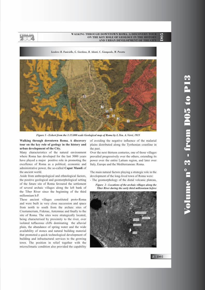
Figure 1 - Exhert from the 1:15.000 scale Geological map of Roma by L.Ten. A. Verri, 1915
Figure 2 - Locations of the archaic villages along the Tiber River during the early third millennium before
D05_R_OK 3 21-05-2004, 16:02:38

V
olu
me n
° 3
- f
rom
D0
5 t
o P
13
D05 -
Leaders: R. Funiciello, G. Giordano, B. Adanti, C. Giampaolo, M. Parotto
D0
5
Tiber river network and the related alluvial deposits- The surface geology and its natural materials - The hydrogeology and microclimatic constraints
Geological setting The Campagna Romana is a portion of the western coast of Central Italy between the Apennine chain and the Tyrrhenian sea. The Apennine chain is a complex structural unit thrusted toward E and NE mainly between the Late Miocene and Early Pliocene. The inner side of the chain has progressively extended westward to form the back-arc Tyrrhenian basin,
whereas, from Tuscany to Sicily a complex volcanic belt, mostly K-rich in composition, developed from Lower Pleistocene to the Present.The open and planar landscape of the Campagna Romana is mainly related to its Quaternary tectonic and volcanic evolution. During the Lower Pleistocene the coast attained approximately its present confi guration with regression from open marine to continental environments. Since the Middle Pleistocene six main volcanic districts erupted thousands of cubic kilometres of magma and emplaced large volume ignimbrite sheets conferring the region its gentle morphology. The ignimbrite plateau was deeply eroded during the last glacial age by the Tiber river fl uvial network and delta. During the subsequent rise of the sea level, the fl uvial network was backfi lled with alluvial Holocene deposits, consisting of unconsolidated clayey-sandy sediments.The deep structure of the Campagna Romana is constituted by extensional highs and lows mainly overprinting pre-existing NW-SE thrusts, which piled up the Mesozoic-Cainozoic carbonatic and terrigenous succession during the Apennine orogeny.The pre-orogenic Mesozoic-Cainozoic sedimentary succession is composed by limestones and marls deposited in the Tuscan and Sabinian basins of the Thetys sea, overlain by an allochtonous terrigenous cover, the “Ligurian fl ysch”, emplaced gravitationally during the early phases of orogeny. This succession is structurally organized in a sequence of ramps and fl ats and it has been encountered in several deep bore-holes in correspondence to structural highs at variable
Figure 3 - Tectonic sketch of the Tyrrhenian margin
Figure 4 - Geological evolution of the Roman area since Pliocene
D05_R_OK 4 21-05-2004, 16:02:53
WALKING THROUGH DOWNTOWN ROMA. A DISCOVERY TOUR ON THE KEY ROLE OF GEOLOGY IN THE HISTORY
AND URBAN DEVELOPMENT OF THE CITY D0
5
5 - D05
Vo
lum
e n
° 3
- f
rom
D0
5 t
o P
13
depths from a minimum of a few hundred meters below the surface (Cristoforo Colombo GRA) to more than 1300 m below the surface (Cesano, Circo Massimo).The post-orogenic terrigenous marine sedimentation along the Tyrrhenian margin started diachronously during the Messinian-Lower Pliocene overlying the deformed Mesozoic-Cainozoic basement. The pre- and syn-depositional development of structural highs and lows, together with the isostatic rebound of the Tyrrhenian margin accompanying the transition from the orogenic to the post-orogenic phases, determined different sedimentary basins, mostly NW-oriented.The post-orogenic stratigraphic succession outcrops discontinuously along the margins of the Apennine chain, in correspondence to structural highs and shallow intrusions of magmatic bodies. Roma is located along one of the NW-trending structural highs, the Monte Mario high, where the Pliocene-Pleistocene sedimentary succession shows the transition from open marine (grey clay and yellow sand) to continental facies (fl uvial-deltaic conglomerate and sand).After the Brunhes-Matuyana reversal, at approximately 780 ka, the Sabatini volcano and the Colli Albani volcano respectively to the NW and to
the SE of Roma, started their activity which lasted till the Late Pleistocene for the Sabatini and till the Holocene for the Colli Albani from the eccentric Albano maar. During this time span, the interplay between volcanism, tectonism and climate changes has produced the alternation of depositional and erosive phases, recorded by the complex arrangement of the Middle-Upper Pleistocene fl uvial terraces along the course of the Tiber river.The sequence of block diagrams illustrates the main paleogeographic events of the environmental and landscape evolution of the Campagna Romana since the Late Pliocene.Pliocene-Early Pleistocene (Santernian-Aemilian). The area corresponding to the future Campagna Romana was submerged by the Tyrrhenian sea and formed an articulated continental platform from which isolated blocks emerged to form islands (Monte Soratte and Monti Cornicolani). The transition from circalittoral to infralittoral facies record the progressive shallowing of the sea level during this period.Early (Sicilian/Villafranchian)-Middle Pleistocene p.p. The marine domains extinguished progressively from east to west because of the regional uplift of the area and accordingly the delta of the paleo-Tiber
Figure 5 - Locations of springs and swamps in Ancient Roman Age
D05_R_OK 5 21-05-2004, 16:00:02
V
olu
me n
° 3
- f
rom
D0
5 t
o P
13
D05 -
Leaders: R. Funiciello, G. Giordano, B. Adanti, C. Giampaolo, M. Parotto
D0
5
river shifted southwestwardly to occupy the Roman area (Ponte Galeria). Later, the extensional tectonics produced a further localised uplift of the NW-trending Monte Mario-Gianicolo rise, shifting the course of the Tiber river farther to the south, parallel to the coast.Middle p.p.-Late Pleistocene (700-125 ka). The progressive edifi cation of the Colli Albani and Sabatini volcanoes, especially with the large volume ignimbrite sheets, deeply modifi ed the river network. The course of the Tiber river was forced back northward in the present position to cross-cut the Monte Mario-Gianicolo rise (likely captured by a minor valley cut on the west fl ank of the Monte Mario rise) to fi nd its way to the reach the sea.Last Glacial Age. The progressive reduction of volcanic activity at the Colli Albani and Sabatini volcanoes, with the consequence of reducing considerably the production of volcanic debris, allowed the climate changes to have a stronger infl uence on landscape evolution. During the last low stand of the sea level related to the Würmian glacial age, the Tiber river valley deeply eroded the volcanic and pre-volcanic rock succession down to the Pliocene clay units. The Campagna Romana assumed the present confi guration with perched relics of the tabular volcanic plateau which represent the present day topographic reliefs of Roma.Holocene. The rise of the sea to the present level has induced the progressive fi lling of the Tiber river valley with its alluvial deposits, forming the alluvial plain closed to the west by the Monte-Mario-Gianicolo
ridge, and, to the east, by the relics of the margin of the volcanic plateau, the famous Seven Hills of Roma.
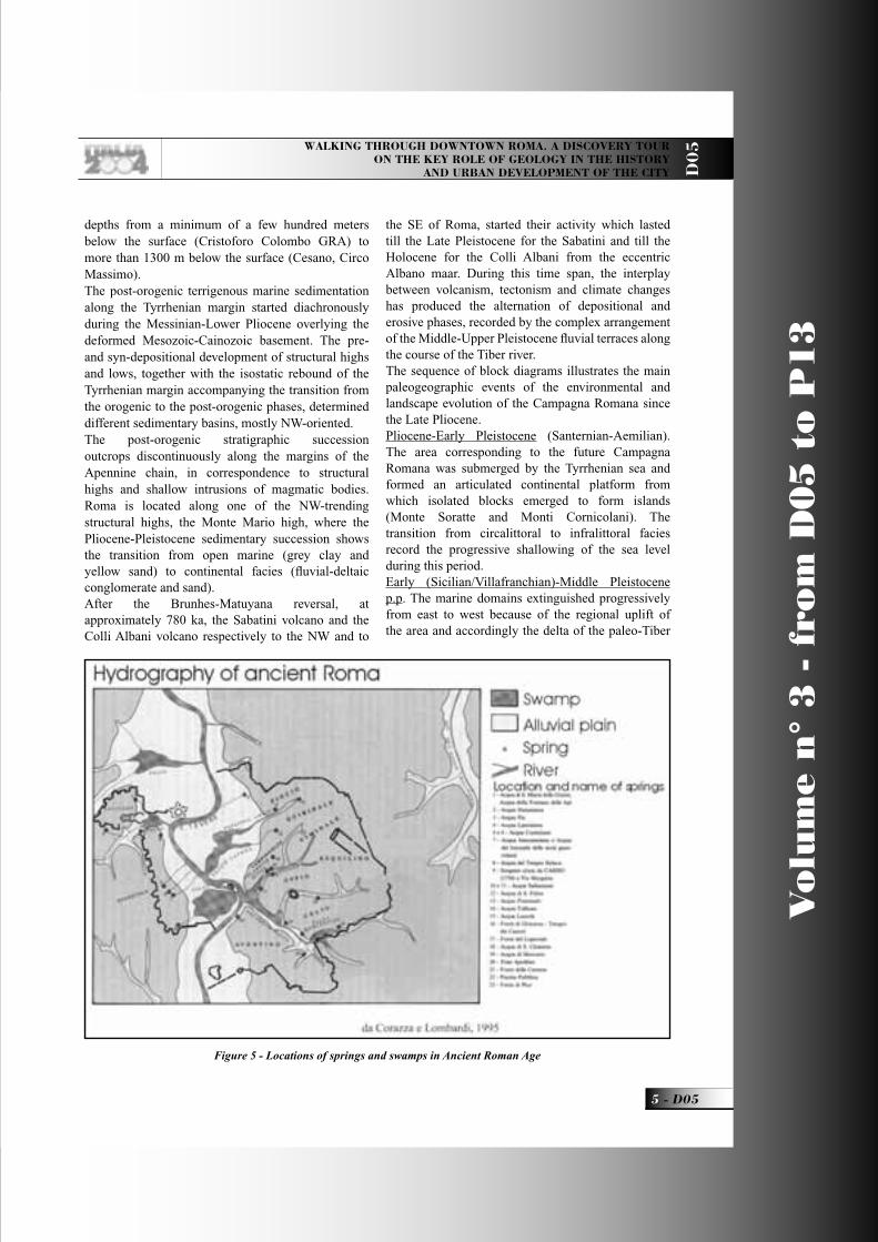
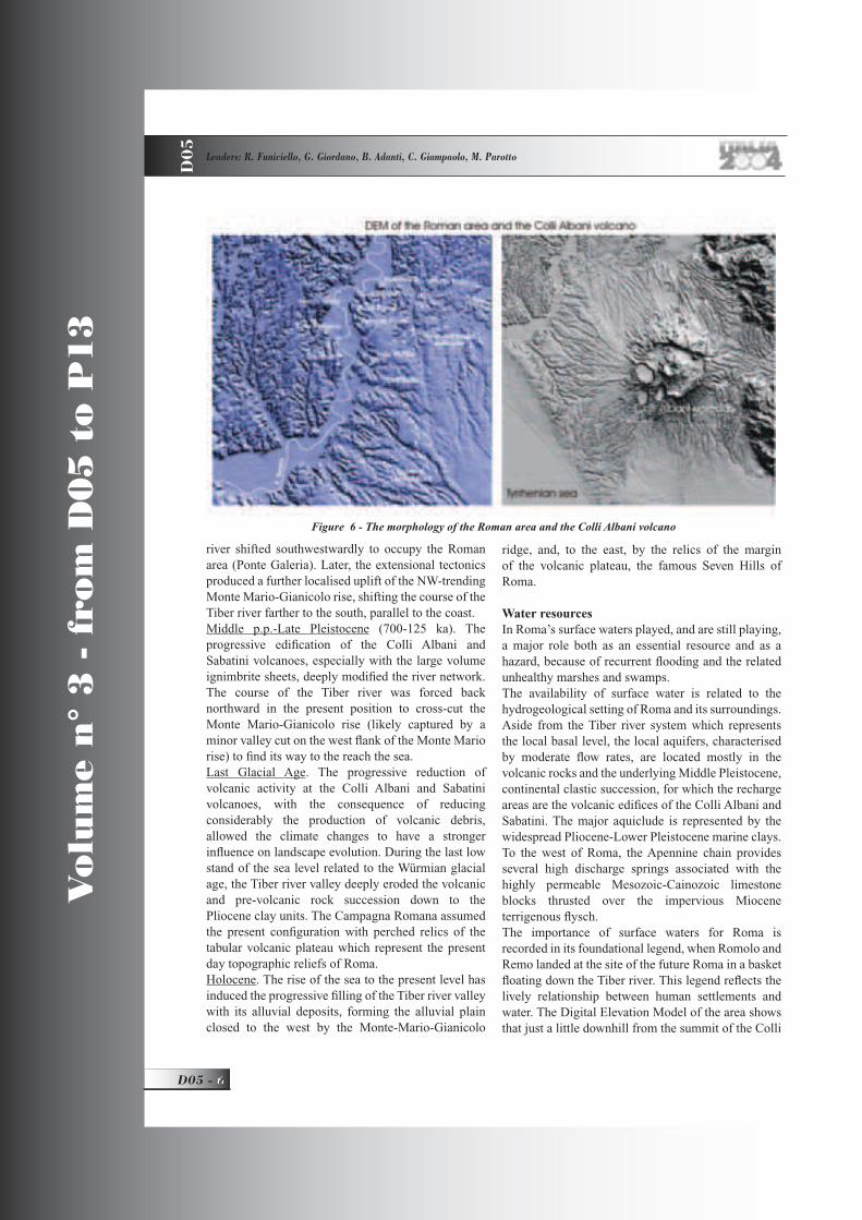
Water resourcesIn Roma’s surface waters played, and are still playing, a major role both as an essential resource and as a hazard, because of recurrent fl ooding and the related unhealthy marshes and swamps. The availability of surface water is related to the hydrogeological setting of Roma and its surroundings. Aside from the Tiber river system which represents the local basal level, the local aquifers, characterised by moderate fl ow rates, are located mostly in the volcanic rocks and the underlying Middle Pleistocene, continental clastic succession, for which the recharge areas are the volcanic edifi ces of the Colli Albani and Sabatini. The major aquiclude is represented by the widespread Pliocene-Lower Pleistocene marine clays. To the west of Roma, the Apennine chain provides several high discharge springs associated with the highly permeable Mesozoic-Cainozoic limestone blocks thrusted over the impervious Miocene terrigenous fl ysch.The importance of surface waters for Roma is recorded in its foundational legend, when Romolo and Remo landed at the site of the future Roma in a basket fl oating down the Tiber river. This legend refl ects the lively relationship between human settlements and water. The Digital Elevation Model of the area shows that just a little downhill from the summit of the Colli
Figure 6 - The morphology of the Roman area and the Colli Albani volcano
D05_R_OK 6 26-05-2004, 10:21:02
WALKING THROUGH DOWNTOWN ROMA. A DISCOVERY TOUR ON THE KEY ROLE OF GEOLOGY IN THE HISTORY
AND URBAN DEVELOPMENT OF THE CITY D0
5
7 - D05
Vo
lum
e n
° 3
- f
rom
D0
5 t
o P
13
Albani volcano, the main and most recent modelling agent in the territory has been surface water in determining ridges and plains.Ridges have typically been utilised for settling, due to the facility of defending and the good geothecnical quality of the rocks, whereas for a long time valleys have hosted only small edifi ces not used for living, because of the unfavourable nature of the unconsolidated alluvial terrains, and of the environment.
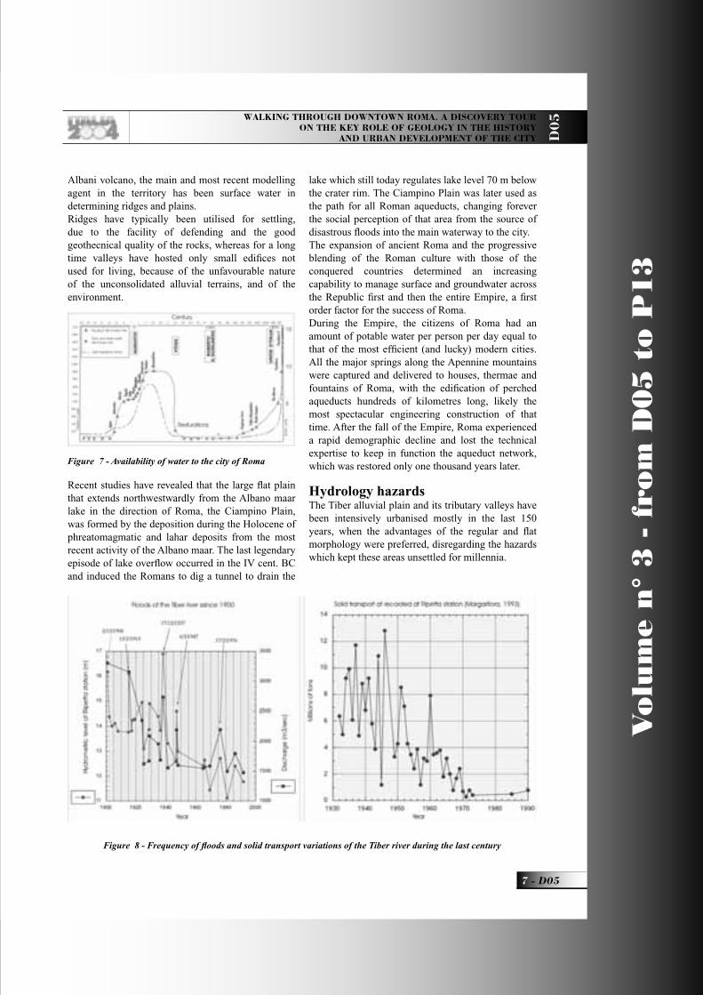
Recent studies have revealed that the large fl at plain that extends northwestwardly from the Albano maar lake in the direction of Roma, the Ciampino Plain, was formed by the deposition during the Holocene of phreatomagmatic and lahar deposits from the most recent activity of the Albano maar. The last legendary episode of lake overfl ow occurred in the IV cent. BC and induced the Romans to dig a tunnel to drain the
lake which still today regulates lake level 70 m below the crater rim. The Ciampino Plain was later used as the path for all Roman aqueducts, changing forever the social perception of that area from the source of disastrous fl oods into the main waterway to the city.The expansion of ancient Roma and the progressive blending of the Roman culture with those of the conquered countries determined an increasing capability to manage surface and groundwater across the Republic fi rst and then the entire Empire, a fi rst order factor for the success of Roma.During the Empire, the citizens of Roma had an amount of potable water per person per day equal to that of the most effi cient (and lucky) modern cities. All the major springs along the Apennine mountains were captured and delivered to houses, thermae and fountains of Roma, with the edifi cation of perched aqueducts hundreds of kilometres long, likely the most spectacular engineering construction of that time. After the fall of the Empire, Roma experienced a rapid demographic decline and lost the technical expertise to keep in function the aqueduct network, which was restored only one thousand years later.
Hydrology hazardsThe Tiber alluvial plain and its tributary valleys have been intensively urbanised mostly in the last 150 years, when the advantages of the regular and fl at morphology were preferred, disregarding the hazards which kept these areas unsettled for millennia.
Figure 7 - Availability of water to the city of Roma
Figure 8 - Frequency of fl oods and solid transport variations of the Tiber river during the last century
D05_R_OK 7 21-05-2004, 16:00:35
V
olu
me n
° 3
- f
rom
D0
5 t
o P
13
D05 -
Leaders: R. Funiciello, G. Giordano, B. Adanti, C. Giampaolo, M. Parotto
D0
5
Embankments have been built to protect the natural alluvial plain from fl oodings and the Tiber river has been progressively regimented with the construction of dams along its course. Floods since the year 1950 have been reduced in number and intensity.
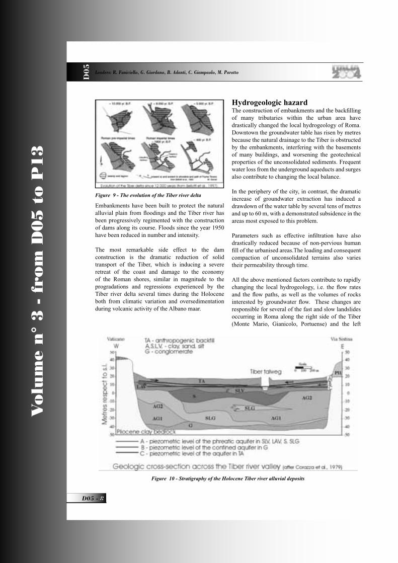
The most remarkable side effect to the dam construction is the dramatic reduction of solid transport of the Tiber, which is inducing a severe retreat of the coast and damage to the economy of the Roman shores, similar in magnitude to the progradations and regressions experienced by the Tiber river delta several times during the Holocene both from climatic variation and oversedimentation during volcanic activity of the Albano maar.
Hydrogeologic hazardThe construction of embankments and the backfi lling of many tributaries within the urban area have drastically changed the local hydrogeology of Roma. Downtown the groundwater table has risen by metres because the natural drainage to the Tiber is obstructed by the embankments, interfering with the basements of many buildings, and worsening the geotechnical properties of the unconsolidated sediments. Frequent water loss from the underground aqueducts and surges also contribute to changing the local balance.
In the periphery of the city, in contrast, the dramatic increase of groundwater extraction has induced a drawdown of the water table by several tens of metres and up to 60 m, with a demonstrated subsidence in the areas most exposed to this problem.
Parameters such as effective infi ltration have also drastically reduced because of non-pervious human fi ll of the urbanised areas.The loading and consequent compaction of unconsolidated terrains also varies their permeability through time.
All the above mentioned factors contribute to rapidly changing the local hydrogeology, i.e. the fl ow rates and the fl ow paths, as well as the volumes of rocks interested by groundwater fl ow. These changes are responsible for several of the fast and slow landslides occurring in Roma along the right side of the Tiber (Monte Mario, Gianicolo, Portuense) and the left
Figure 9 - The evolution of the Tiber river delta
Figure 10 - Stratigraphy of the Holocene Tiber river alluvial deposits
D05_R_OK 8 21-05-2004, 16:00:40
WALKING THROUGH DOWNTOWN ROMA. A DISCOVERY TOUR ON THE KEY ROLE OF GEOLOGY IN THE HISTORY
AND URBAN DEVELOPMENT OF THE CITY D0
5
9 - D05
Vo
lum
e n
° 3
- f
rom
D0
5 t
o P
13
side along the Aniene valley, the city centre and the Ostiense area.
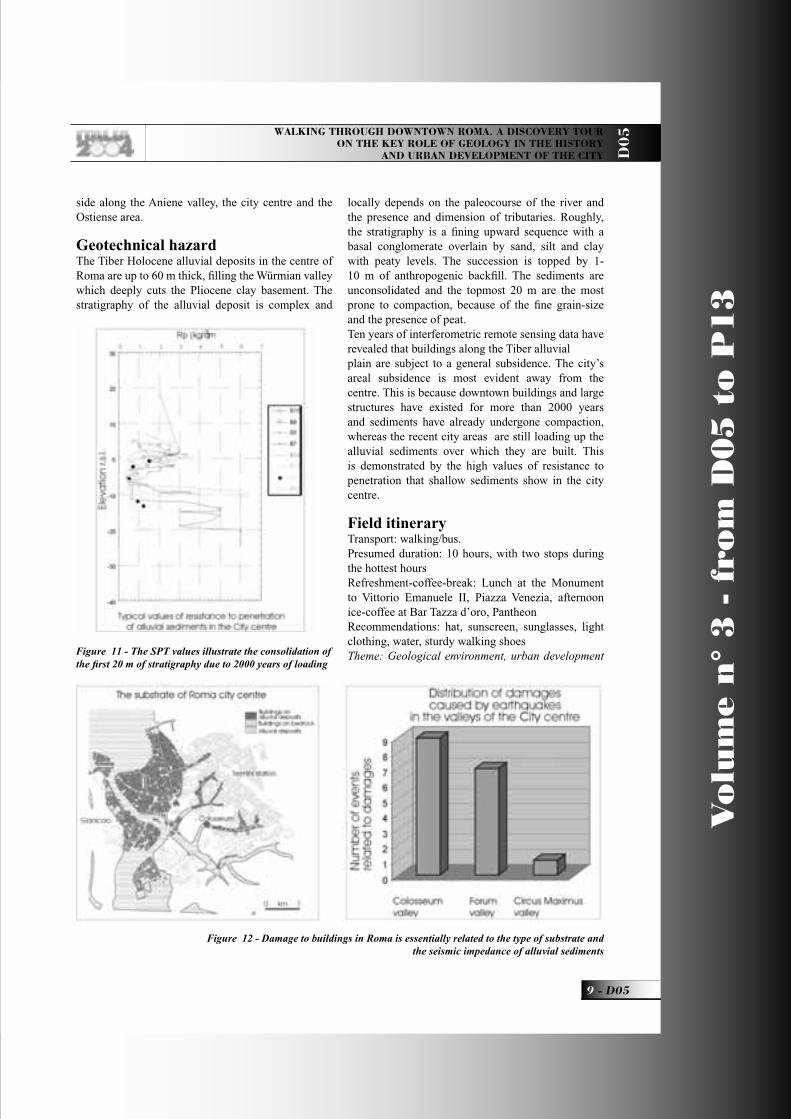
Geotechnical hazardThe Tiber Holocene alluvial deposits in the centre of Roma are up to 60 m thick, fi lling the Würmian valley which deeply cuts the Pliocene clay basement. The stratigraphy of the alluvial deposit is complex and
locally depends on the paleocourse of the river and the presence and dimension of tributaries. Roughly, the stratigraphy is a fi ning upward sequence with a basal conglomerate overlain by sand, silt and clay with peaty levels. The succession is topped by 1-10 m of anthropogenic backfi ll. The sediments are unconsolidated and the topmost 20 m are the most prone to compaction, because of the fi ne grain-size and the presence of peat.Ten years of interferometric remote sensing data have revealed that buildings along the Tiber alluvial plain are subject to a general subsidence. The city’s areal subsidence is most evident away from the centre. This is because downtown buildings and large structures have existed for more than 2000 years and sediments have already undergone compaction, whereas the recent city areas are still loading up the alluvial sediments over which they are built. This is demonstrated by the high values of resistance to penetration that shallow sediments show in the city centre.
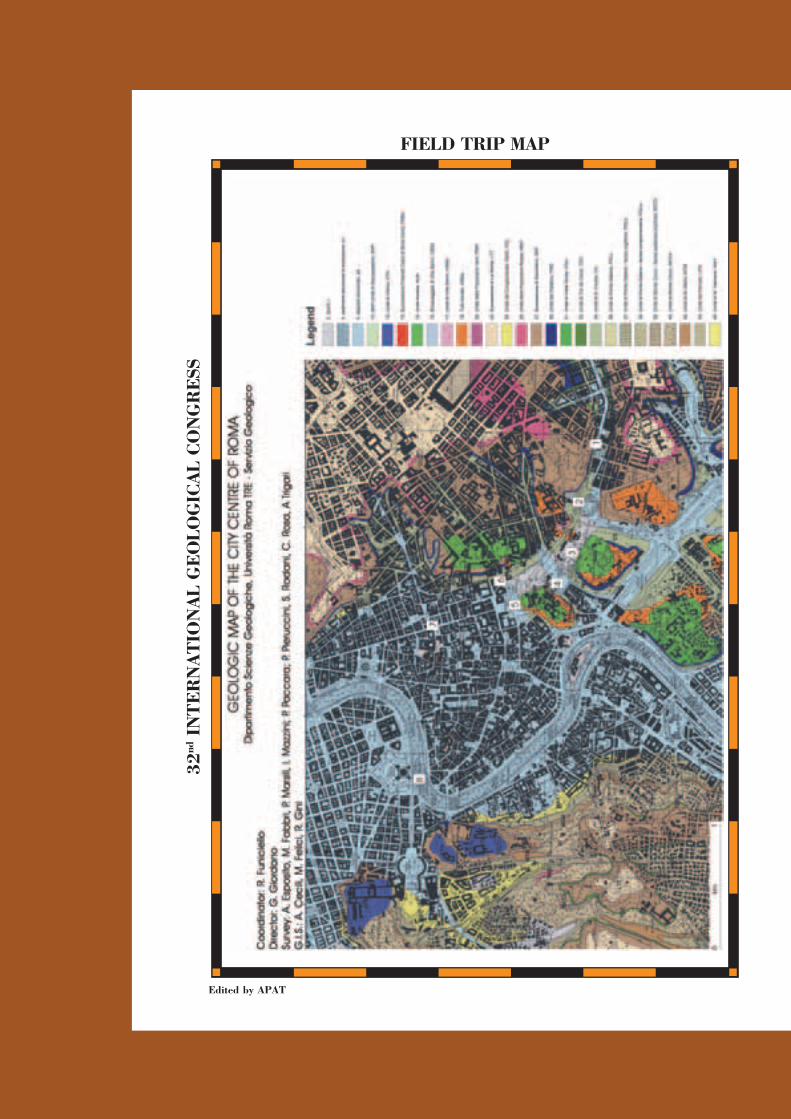
Field itineraryTransport: walking/bus.Presumed duration: 10 hours, with two stops during the hottest hoursRefreshment-coffee-break: Lunch at the Monument to Vittorio Emanuele II, Piazza Venezia, afternoon ice-coffee at Bar Tazza d’oro, PantheonRecommendations: hat, sunscreen, sunglasses, light clothing, water, sturdy walking shoesTheme: Geological environment, urban development Figure 11 - The SPT values illustrate the consolidation of
the fi rst 20 m of stratigraphy due to 2000 years of loading
Figure 12 - Damage to buildings in Roma is essentially related to the type of substrate and the seismic impedance of alluvial sediments
D05_R_OK 9 21-05-2004, 16:00:43

V
olu
me n
° 3
- f
rom
D0
5 t
o P
13
D05 -
Leaders: R. Funiciello, G. Giordano, B. Adanti, C. Giampaolo, M. Parotto
D0
5
and conservation related to geological hazards
Start at 8.30 at Colosseo Line B Metro Station
Stop 1:S. Clemente Basilica: The stratigraphy of the City.We start walking along the thalweg of the Fosso Labicano, a small tributary creek of the Tiber, along which the Coliseum is built. The San Clemente Basilica is an excellent example of how the city is stratifi ed. The site was part of the Neronian Domus Aurea in the I a.C., later destroyed by the Flavian emperors, who destined the site to the edifi cation of the Bank of Roma (La Moneta) during the II a.C. The building was transformed into a residence with annexed Mitreo during the III a.C. and fi nally became the paleoChristian S. Clemente basilica in the IV a.C. The church was destroyed by the fi re set by the Normans in 1084 and later restored with the edifi cation of the second fl oor under the pontifi cate of Pasquale II, with a fi nal restoration by Carlo Stefano Fontana in 1713-1719.The Basilica is made with beautiful ornamental stones, such as the Africano or Marmor Luculleum for the fl oor and some columns, the Granito del Foro (Forum granite) or Marmor Claudianum for the 5th columns, the Granito di Aswan (Aswan granite), an Egyptian syenite, the Porfi do Rosso Antico (ancient red porphyry), an andesite from Egypt and the Portasanta which constitute the columns of the altar. The perimeter walls of the basilica are damaged and
the fl oor of the upper basilica is undulated. This damage is related to the unconsolidated nature of the ground, which induces differential subsidence and is also prone to the amplifi cation of seismic waves.
Stop 2:The Colosseum and seismic hazards.The amphitheatre has a concrete elliptical basement 13 m thick composed of four unifi ed sectors opening westward to Porta Triumphalis and eastward to Porta Libitina. The monument is made of blocks of welded scoria from the Colli Albani (local name sperone) and of Tivoli travertine fi xed by metallic supports and was once covered with white marble plates. The columns of the Summa Cavea arches are made of marble from
Figure 13 - Geological setting of the Colosseum and the perfect correspondence between the Fosso Labicano sediments and the collapsed wall.
Figure 14 - The synthetic earthquake visualises the site effect on seismic wave amplifi cation.
D05_R_OK 10 21-05-2004, 16:00:45

WALKING THROUGH DOWNTOWN ROMA. A DISCOVERY TOUR ON THE KEY ROLE OF GEOLOGY IN THE HISTORY
AND URBAN DEVELOPMENT OF THE CITY D0
5
11 - D05
Vo
lum
e n
° 3
- f
rom
D0
5 t
o P
13
Marmara island in Turkey.The site of the Colosseum was previously an artifi cial pond surrounded by houses of the nobility, gardens and parks. The amphitheatre site was cleared and prepared for residence in Nero’s time. The monument was fi nally realised by the Flavian Emperors, Titus and Domitian.The eastern regio of ancient Roma was planned for large public buildings dedicated to entertainment: main public baths (Diocletian, Trajan, Titus and Caracalla thermae), large stadiums (Circus Maximus and Varianus) and amphitheatres (Castrense and Colosseum) were located away from the political and commercial centre of the city.
The small artifi cial pond was located along the Fosso Labicano creek, probably created with an artifi cial dam. The Colosseum was half built on the bedrock, here consisting of pre-volcanic conglomerate and sand, and half on the Fosso Labicano thalweg; the contrast of seismic impedance between the bedrock and the unconsolidated sediments of the Fosso
Labicano in time produced the main damage and a partial collapse of the outer wall of the monument when in 1349 a strong earthquake in the Apennine region struck Roma.
Stop 3:The Via Sacra: The entrance to the Roman Forum; local springs, building and ornamental stones.Just outside the Colosseum, the via Sacra crosses the Titus arch and enters the Forum. Near the eastern entrance, it is possible to observe the site of the Meta sudans fountain, demolished 70 years ago and presently under restoration. The spring drains a shallow aquifer located within the pre-volcanic conglomerate and sand, which crops out for lateral contact with the fi ne-grained sediments of the buried Fosso Labicano. Small springs like this one were the earliest source of water for ancient Roma.Walking across the Roman Forum we observe traces of the development of Roma from the Villanovian villages to the Imperial residences, the record of thousands of years of settlement at the
Figure 15 - Examples of marbles and ornamental stones used in the Roman Forum
D05_R_OK 11 21-05-2004, 16:03:46
V
olu
me n
° 3
- f
rom
D0
5 t
o P
13
D05 -
Leaders: R. Funiciello, G. Giordano, B. Adanti, C. Giampaolo, M. Parotto
D0
5
Palatine Hill.The most common stones in the Forum are local, like the Lapis Albanus, a phreatomagmatic ignimbrite erupted from the Albano maar, and travertine from Tivoli. Exotic stones are also common such as Marmo Misio, a granite from Turkey, Africano, a breccia from Turkey, and the Cipollino dell’Eubea, a chloritoschist from Greece, which are used in the Basilica Emilia, or the Paonazzetto, a breccia from Dokimeion in Turkey, Breccia verde d’Egitto, a breccia from Mons Basanites in Egypt, used for the Antiquarium columns, or the Giallo Antico, a marble from Djebel Chemtou in Tunisia, the white and black tesserae of opus sectile made of Granito del Foro, a quartzdiorite from Mons Claudianus in Egypt, and the Granito della Colonna, a gabbrodiorite from Mons Porphyrites in Egypt.All these stones were removed by the architect Carlo Fontana for the construction of the Fontanone dell’Acqua Paola on the Gianicolo hill (1690-1698).
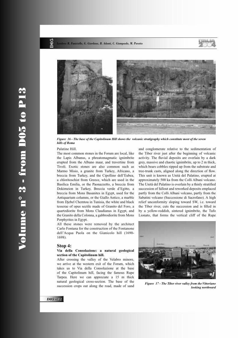
Stop 4:Via della Consolazione: a natural geological section of the Capitolinum hill.After crossing the valley of the Velabro minore, we arrive at the western exit of the Forum, which takes us to Via della Consolazione at the base of the Capitolinum hill, facing the famous Rupe Tarpea. Here we can appreciate a 15 m thick natural geological cross-section. The base of the succession crops out along the road, made of sand
and conglomerate relative to the sedimentation of the Tiber river just after the beginning of volcanic activity. The fl uvial deposits are overlain by a dark grey, massive and chaotic ignimbrite, up to 2 m thick, which bears cobbles ripped up from the substrate and tree-trunk casts, aligned along the direction of fl ow. This unit is known as Unità del Palatino, erupted at approximately 500 ka from the Colli Albani volcano. The Unità del Palatino is overlain by a thinly stratifi ed succession of fallout and reworked deposits emplaced partly from the Colli Albani volcano, partly from the Sabatini volcano (Successione di Sacrofano). A high relief unconformity sloping toward SW, i.e. toward the Tiber river, cuts the succession and is fi lled in by a yellow-reddish, sintered ignimbrite, the Tufo Lionato, that forms the vertical cliff of the Rupe
Figure 16 - The base of the Capitolinum Hill shows the volcanic stratigraphy which constitute most of the seven hills of Roma
Figure 17 - The Tiber river valley from the Vittoriano looking northward
D05_R_OK 12 21-05-2004, 16:01:05

WALKING THROUGH DOWNTOWN ROMA. A DISCOVERY TOUR ON THE KEY ROLE OF GEOLOGY IN THE HISTORY
AND URBAN DEVELOPMENT OF THE CITY D0
5
13 - D05
Vo
lum
e n
° 3
- f
rom
D0
5 t
o P
13
Tarpea, infamous because the Romans threw their undesired children down from here. The Tufo Lionato was emplaced at 350 ka from the largest volume, caldera-forming eruption of the Colli Albani. It is the most widely used stone for construction in the Roman area for its lithoidal and light characteristics. The succession is topped by a bedded fl uvial sedimentary
deposit, emplaced during the high stand of the sea level subsequent to the eruption of the Tufo Lionato (Unità di Aurelia).
Stop 5:Lunch at the Vittorio Emanuele II monument and panoramic point.The monument was built to celebrate the king of Italy Vittorio Emanuele II in early part of the last century devastating part of the Roman Forum. The monument is made mainly with the Botticino classico, a limestone coming from the pre-Alps near Milan. The columns are made of Calcare di Mazzano, a variety of the Botticino, whereas the frontal four columns are made of Portasanta, a breccia from Gavorrano, Tuscany.The geomorphology of Roma can be appreciated looking northward from the terrace. The fl at alluvial plain of the Tiber river, which hosts the City centre, is sided to the east by the smooth hills cut in the Colli Albani ignimbrite plateau: the Viminale and the Quirinale. Behind the Quirinale, the left bank of the Tiber alluvial plain continues with the Pincio hill, just
Figure 18 - The Colli Albani volcano dominating the city of Roma, looking southward from the Vittoriano
Figure 19 - Location of Torre dei Conti in respect to the Trajan Forum and the thalweg of the Fosso del Velabro, which justifi es the decapitation of the tower during the 1349 earthquake
D05_R_OK 13 21-05-2004, 16:04:30

V
olu
me n
° 3
- f
rom
D0
5 t
o P
13
D05 -
Leaders: R. Funiciello, G. Giordano, B. Adanti, C. Giampaolo, M. Parotto
D0
5
over Piazza di Spagna (Spanish steps).To the west, the Tiber valley is confi ned by the Gianicolo-Monte Mario hill, a continuous cliff with an altitude from 60 m to 144.5 m a.s.l. The hill exposes the pre-volcanic succession. The base, approximately up to 40-60 m a.s.l., is made of the Pliocene, circalittoral grey clay of the Unità di Monte Vaticano, which are faulted and tilted.A planar angular unconformity fl attens the top of the Unità di Monte Vaticano and is overlain by the Lower Pleistocene Unità del Farneto made of clay, silt and sand of infralittoral environment, which transitionally passes upward to the Unità di Monte Mario, made of infralittoral to littoral, grey sand with Artica islandica at the base overlain by yellow sand. The Unità di Monte Mario makes most of the Monte Mario hill up to the 144.5 m of the top and testifi es to the progressive shallowing of the sea during the Early Pleistocene. Lower-Middle Pleistocene fl uvial-deltaic deposits overlie the marine succession and form a sedimentary wedge that thickens to the west-southwest, known as Unità di Ponte Galeria, in turn overlain by a thin sheet of volcanic deposits. The uplift of Monte Mario occurred in several subsequent phases, but the most important episode must have occurred just prior to the beginning of volcanic activity, shifting the course of the paleo-Tiber toward the southeast.
Stop 6:The Trajan Forum, the Trajan column and the Torre dei ContiWe walk down the Vittorio Emanuele II monument to Piazza Venezia, on the eastern side of which is prominently situated the beautiful Trajan column at the edge of the Trajan Forum. The column is made of 18 pieces of Marmo Bianco di Luni, i.e. the Carrara marble. The importance of this monument will be explained at the next stop, when the perfect integrity of the column, built over the sedimentary bedrock, will be compared with the state of the twin Marco Aurelio column built over the unconsolidated Tiber alluvial sediments.The Trajan Forum has a wide square at its centre originally paved with Marmo Bianco di Luni, later removed during Mediaeval times. The Forum is sided by arcades made with Paonazzetto stones and granite.To the south-eastern side of the Forum, the Torre dei Conti can be seen, built over the unconsolidated sediments of the Fosso del Velabro, presently the site of Via Cavour. The tower, as can be seen in the Figure, was a three-stage construction built in the
XIII century over the ruins of the Tempio della Pace, destroyed by an earthquake in the II century b.C.. In 1349, Roma was struck by one of the strongest earthquakes originating in the Apennines. The top part of the tower was knocked down and assumed its
Figure 20 - A synthetic earthquake illustrating the amplifi cation of seismic waves across the site of the Marco
Aurelio column
Figure 21 - A detail of the dislocation of two sections of the Marco Aurelio column
D05_R_OK 14 21-05-2004, 16:01:26
WALKING THROUGH DOWNTOWN ROMA. A DISCOVERY TOUR ON THE KEY ROLE OF GEOLOGY IN THE HISTORY
AND URBAN DEVELOPMENT OF THE CITY D0
5
15 - D05
Vo
lum
e n
° 3
- f
rom
D0
5 t
o P
13
present shape.Description of fi gure 19 clockwise from top left: Trace of the Fosso del Velabro minore in respect to the location of the Trajan Forum and the Torre dei Conti; Illustration of the Torre dei Conti before the earthquake of 1349; The Torre dei Conti decapitated as it stands today; Geological cross section across the Trajan Forum, illustrating the geometry of the unconsolidated alluvium of the Fosso del Velabro. Note that the Torre dei Conti is located at the edge of the palaeovalley, in proximity of the bedrock.
Stop 7:The Marco Aurelio column: a comparative scenario in seismic shaking of the imperial columnsWe walk from the Trajan Forum along Piazza Venezia and Via del Corso to Piazza Colonna where the Marco Aurelio column is located. The column is identical to the Trajan column described at the previous stop. The state of conservation, though, is completely different. The pieces composing the column are dislocated and rotated so that the carvings appear damaged. Originally the sections of the columns were connected with lead joints, but by Mediaeval time these joints had been removed. Without joints, the sections of the columns were free to move in respect to each other during seismic shaking. The different conditions of the two identical columns can be explained by the difference in seismic impedance of the different substrates onto which they were built. Experimental analogue and numerical modelling have shown that the resonance frequencies
of both the column and the alluvial sediments fi lling the Tiber river valley have the same value of 2 Hz. This coincidence explains why the shaking of the ground at the site of the Marco Aurelio column produces an amplifi cation of the shaking of the column, and therefore damage, whereas the same condition is not experienced by the Trajan column which lies on bedrock.After this stop we walk toward the Pantheon, Piazza Navona and then toward Ponte S. Angelo over the Tiber river.
Stop 8:The Roman bridges, Castel Sant’Angelo and the walls protecting Roma from the fl oods.Ponte S. Angelo bridges the City centre with the right bank of the Tiber, in front of Castel S. Angelo, the unique rounded Mediaeval castle built over the ruins of the Emperor Adrian’s Mausoleum. The three arches of the bridge are still those of the Roman age Ponte Elio. From the bridge you can see the travertine embankment walls that contain the river, built after the last fl ood that inundated the Roma city centre in 1870. That same year the army of the Italian kingdom conquered Roma defeating the last resistance of the Vatican troops. Pope Pious IX read the fl ood as the sign of God’s anger condemning the fall of Roma, and the Piedmontese answered pragmatically sending engineers to build up the embankments. The Tiber since then has progressively lost its connection with the life of the City, which has been recovering only in the last years.
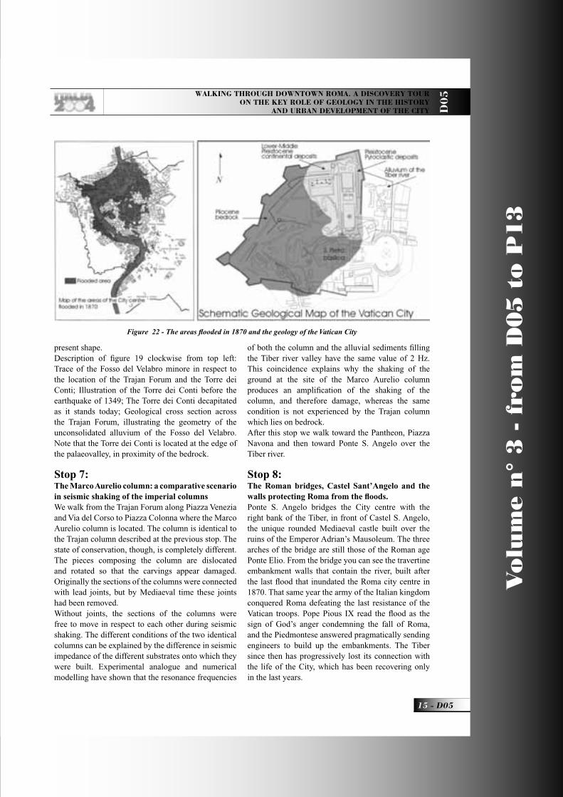
Figure 22 - The areas fl ooded in 1870 and the geology of the Vatican City
D05_R_OK 15 21-05-2004, 16:01:29
V
olu
me n
° 3
- f
rom
D0
5 t
o P
13
D05 -
Leaders: R. Funiciello, G. Giordano, B. Adanti, C. Giampaolo, M. Parotto
D0
5
To the west, the cupola of St. Peter’s Basilica can be seen and can be reached with a short optional walk.St. Peter’s is another excellent example of how the geology of the substrate onto which monuments have been built has played a major role in their conservation and in history. The site is that of the palaeo-Christian Constantine basilica which was damaged during the 1349 earthquake because it was built across the limit between the consolidated Pliocene clay bedrock and the unconsolidated alluvial sediments. The original project for the new St. Peter’s Basilica was therefore entirely planned on the bedrock by Bramante and only later Maderno and Bernini designed the central nave and the piazza with the arcade that extends over the alluvial sediments.
Essential ReferencesBozzano F, Funiciello R, Marra M, Rovelli A, Valentini G, (1995), Il sottosuolo dell’area dell’anfi teatro Flavio in Roma. Geologia Applicata e Idrogeologia XXX, parte I, 405-422Capelli G, Mazza R, Giordano G, Cecili A, de Rita D, Salvati R, (2000), The Colli Albani Volcano, equilibrium breakdown of a hydrogeological unit as a result of unplanned and uncontrolled overexploitation (Roma, Italy). Hydrgeologie, 4, 63-70Cavarretta G, Gioia P, Mussi M, Palombo MR, (2001), La Terra degli Elefanti – The World of Elephants.
Proceedings of the I International Congress, CNR, Roma. Dipartimento Scienze Geologiche Università ROMA TRE, Carta Geologica del Comune di Roma alla scala 1:10.000, Volume 1. Comune di Roma – X Ripartizione, 17 sheets with explanatory notes.Funiciello R (ed), (1995), La Geologia di Roma – Il Centro Storico. Mem. Soc. Geol. It, L, 550 p.Funiciello R, Giordano G, de Rita D, (2003), The Albano maar lake (Colli Albani Volcano, Italy): recent activity and evidence of pre-Roman Age catastrophic lahar events. J. Volcanol. Geotherm. Res., 123, 43-61.Giampaolo C, Di Pace A, Bartolini G, Adanti B, (2000): http://www.italithos.uniroma3.it Giordano G., Esposito A., de Rita D., Fabbri M., Mazzini I., Trigari A., Rosa C., Funiciello R., (2003), The sedimentation along the Roman coast between Middle and Upper Pleistocene: the interplay of eustatism, tectonics and volcanism – new data and review. Italian Journal of Quaternary Sciences, spec. Vol INQUA, 16(1bis)Giordano G, Mazza R & Funiciello R, Capelli G, Parotto M (2004), Geology of Metropolitan Areas – The SW sector of Roma (Italy). Atlas of cartography for the 32° Congress of the International Geological Society, Firenze 2004.Gnoli R., (1988), Marmora Romana. Edizioni dell’Elefante, Roma, 289 p.
D05_R_OK 16 21-05-2004, 16:01:31

Back Cover: fi eld trip itinerary
D05_copertina_R_OK E 21-05-2004, 15:54:53
Edited by APAT
FIELD TRIP MAP
32nd
IN
TE
RN
AT
ION
AL
GE
OLO
GIC
AL
CO
NG
RE
SS
D05_copertina_R_OK B 26-05-2004, 10:17:56