Embed Size (px)
Citation preview
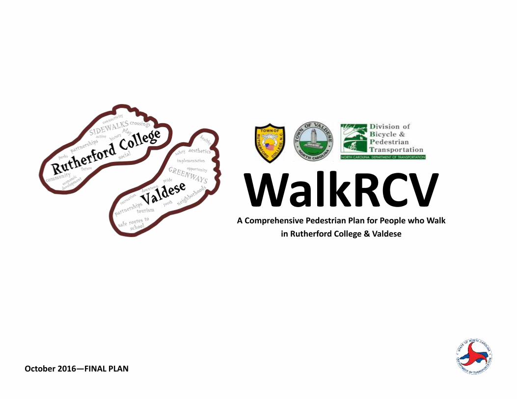
WalkRCV A Comprehensive Pedestrian Plan for People who Walk
in Rutherford College & Valdese
October 2016—FINAL PLAN
This page intentionally blank for printing purposes
WALKRCV I
A Comprehensive Plan for People who Walk in Rutherford College & Valdese
Table of Contents Page 1. Executive Summary & History ........................................................................ 1
2. Building the Plan ................................................................................................ 5
3. Walk this Way ...................................................................................................... 13
4. Policy: Walking the Walk .................................................................................. 19
5. The Potential of Greenways ............................................................................. 29
6. Get Out and Walk ............................................................................................... 35
7. Building a System for People Who Walk ...................................................... 41
8. Design for People Who Walk ........................................................................... 61
9. Safety & Enforcement ........................................................................................ 73
10. The Wonder Drug.............................................................................................. 77
11. Implement & Evaluate ...................................................................................... 85
Appendix ................................................................................................................... 93
Acknowledgments Thank you to the following organizations and individuals that contribute to WalkRCV.
Gary McClure, Mayor of Rutherford College
Gary Delp, Valdese Town Board
Wayne Annas, Rutherford College Town Board
David Thompson, Valdese Planning Board
Tracy Rich, Rutherford College Planning Board
Laura Mancini, Rutherford College Planning Board
James Huffman, Rutherford College Planning Board
Kenneth Geathers, Rutherford College
Town Manager
Larry Johnson, Valdese Planning Director
Elinor Hiltz, Western Piedmont COG
Erin Schotte, Western Piedmont COG
Bryan Poole & Betsy Kane, NCDOT Division of
Bicycle & Pedestrian Transportation
Kristina Solberg, NCDOT Division 13
Mary Smith, Active Routes to School
Sonni Dyer, active living advocate
Danny Griffith, pedestrian advocate
Donnie Edwards, health advocate
Keisha Bowman, Valdese Elementary School
II WALKRCV
A Comprehensive Plan for People who Walk in Rutherford College & Valdese
List of Exhibits 2-1: Survey: How often do you walk for the following purposes? ............................................................................... 9
2-2: Survey: Which of the following would encourage you to walk more often? ........................................................ 9
2-3: Survey: Other Key Findings .................................................................................................................................. 10
2-4: Census Data by Age Group .................................................................................................................................. 11
2-5: Census Journey to Work Data ............................................................................................................................. 12
3-1: Existing Sidewalks & Street Characteristics ......................................................................................................... 14
3-2: Existing Conditions Map ....................................................................................................................................... 15
3-3: Survey: Where would you walk if it were safer or more convenient to do so? ..................................................... 16
3-4: Survey: Rate the importance of developing the following connections? ............................................................. 16
3-5: Survey: Destinations where connections are important ..................................................................................... 17
3-6: Survey: Specific locations where there are pedestrian hazards or barriers .......................................................... 18
4-1: How Policies Impact Walkability .......................................................................................................................... 21
4-2: Comprehensive Plans Review: Goals & Objectives .............................................................................................. 22
4-3: Valdese Vision & Influences on Walkability ......................................................................................................... 23
4-4: Zoning & Subdivision Ordinance Assessment ....................................................................................................... 28
5-1: Planning for Greenways ....................................................................................................................................... 31
5-2: Common Greenway Design Features ................................................................................................................... 33
6-1: Pedestrian Laws in North Carolina ....................................................................................................................... 36
7-1: How Projects Were Identified .............................................................................................................................. 43
7-2: Project Ranking Criteria ....................................................................................................................................... 44
7-3: Project Recommendations Map ........................................................................................................................... 45
8-1: Operational width & Clearance Requirements ..................................................................................................... 63
8-2: Standard Drawing for Curb Ramp (NCDOT 848.05) .............................................................................................. 64
8-3: Best Practices for Curb Ramps ............................................................................................................................. 64 8-4: Pushbutton Location Area (MUTCD; Figure 4E-3) ................................................................................................. 66 8-5: Typical Crossing Treatment for Multi-Use Trail at a Two-lane Road .................................................................... 67
8-6: Typical Crossing Treatment for Multi-Use Trail at a four-lane highway ............................................................. 68 8-7: Alternative pedestrian facilities ........................................................................................................................... 71
8-8: Design Resources ................................................................................................................................................. 72
9-1: The impact of vehicle speed ................................................................................................................................. 74
9-2: Injured body regions of a pedestrian when hit by a motorist ............................................................................... 75
10-1: This is your brain on walking .............................................................................................................................. 78
10-2: The Health Benefits of Walking .......................................................................................................................... 79
10-3: Behavior change resulting from a mile of new sidewalks/greenways................................................................. 81
10-4: The 7 Dimensions of Health in Rutherford College & Valdese ............................................................................ 83
10-5: Broad Health Benefits of Walking-Related Facilities Investments ...................................................................... 84
11-1: Action Steps for Implementations ...................................................................................................................... 87
11-2: Evaluation Measures .......................................................................................................................................... 89
11-3: Job Creation Potential of Walking Facilities ........................................................................................................ 90
WALKRCV 1
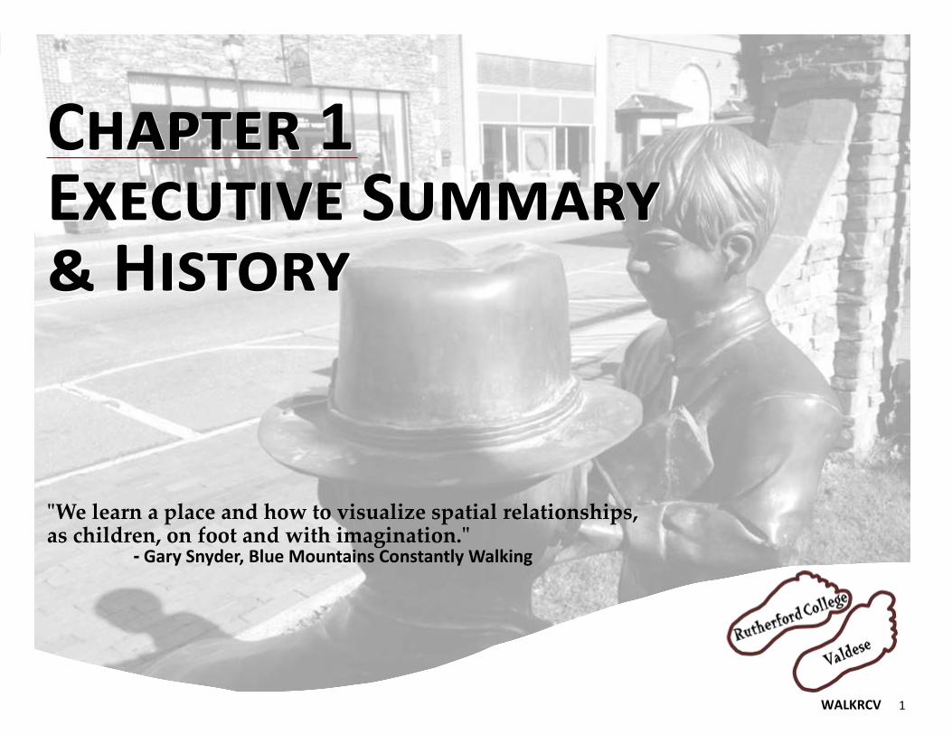
Chapter 1 Executive Summary & History
Chapter 1 Executive Summary & History
"We learn a place and how to visualize spatial relationships, as children, on foot and with imagination." - Gary Snyder, Blue Mountains Constantly Walking

2 WALKRCV
A Comprehensive Plan for People who Walk in Rutherford College & Valdese
Why a Plan for People who Walk? In September 2015 the United States Surgeon General
issued a call to action. Such calls to action are reserved
for only the most important health issues facing the
country. In it, the Surgeon General stated:
“Americans need to walk regularly to combat
heart disease and diabetes, while at the same
time recognizing that the way neighborhoods are
designed often are unsafe or aren’t conducive to
walking.”
People walk every day for recreation and for transporta-
tion; we just don’t always acknowledge it. Walking is
oftentimes called “alternative transportation” in policy
and funding realms. There is nothing alternative about
it; walking is the original form of transportation.
For more than 2,000 years our towns and cities were
designed for original transportation. It has only been
within the last 100 years that our communities were
designed to inhibit original transportation. Walking,
along with bicycling, was a normal everyday occurrence
in small towns for decades.
The quaint downtowns that dot North Carolina are relics
of this formerly bygone era but hold great potential to
help communities address emerging health issues called
out by the Surgeon General.
A Comprehensive Pedestrian Plan The Towns of Rutherford College and Valdese are seek-
ing to make their communities more walkable through
this Comprehensive Pedestrian Plan.
The North Carolina Department of Transportation (NCDOT)
recognizes the vital role walking plays in small town econom-
ic development, health and creating a safe place for people
of all ages and abilities. This is why the agency has encour-
aged and funded plans for people who walk for more than a
decade. Rutherford College and Valdese pursued a grant
through NCDOT’s annual call for proposals for walking and
bicycling plans in 2015.
The application stated the two towns have a vision of
“becoming walkable communities with connected sidewalks
and off-road pathways that allow their citizens safe, pedestri-
an access within and between both towns.”
A joint planning effort for walkability is a rare occurrence in
the United States. Too often communities are limited in their
ability and desire to jointly pursue improvements in concert
with a neighboring community. Rutherford College and Val-
dese are pioneering pedestrian planning for North Carolina
with this joint effort and seek to build stronger relations be-
tween the two towns beyond walkability.
A joint approach is invaluable given current financial realities
and the everyday burdens placed upon small towns. Ruther-
ford College and Valdese are neighbors in eastern Burke
County. Over the last 10 years, Burke County has seen dra-
matic job loss as textile and furniture industries have left for
foreign locations.
The County is showing signs of improvement as it diversifies
its job and employment base. In 2014, Burke County was des-
ignated as an economically distressed county by the NC De-
partment of Commerce. The state moved the county into a
less-distressed category in 2015.
Valdese and Rutherford College emerged in an era when walking was the transportation mode of choice. This plan seeks to make it a safe choice once again.
WALKRCV 3
A Comprehensive Plan for People who Walk in Rutherford College & Valdese
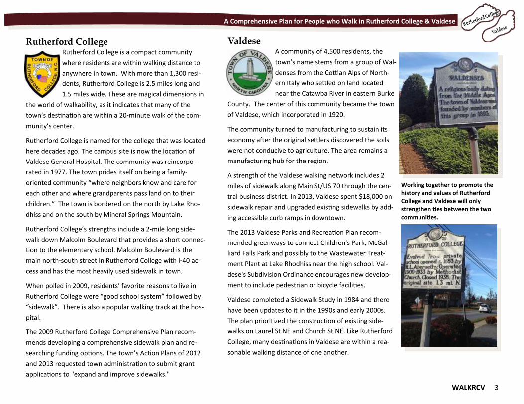
Rutherford College Rutherford College is a compact community
where residents are within walking distance to
anywhere in town. With more than 1,300 resi-
dents, Rutherford College is 2.5 miles long and
1.5 miles wide. These are magical dimensions in
the world of walkability, as it indicates that many of the
town’s destination are within a 20-minute walk of the com-
munity’s center.
Rutherford College is named for the college that was located
here decades ago. The campus site is now the location of
Valdese General Hospital. The community was reincorpo-
rated in 1977. The town prides itself on being a family-
oriented community “where neighbors know and care for
each other and where grandparents pass land on to their
children.” The town is bordered on the north by Lake Rho-
dhiss and on the south by Mineral Springs Mountain.
Rutherford College’s strengths include a 2-mile long side-
walk down Malcolm Boulevard that provides a short connec-
tion to the elementary school. Malcolm Boulevard is the
main north-south street in Rutherford College with I-40 ac-
cess and has the most heavily used sidewalk in town.
When polled in 2009, residents’ favorite reasons to live in
Rutherford College were “good school system” followed by
“sidewalk”. There is also a popular walking track at the hos-
pital.
The 2009 Rutherford College Comprehensive Plan recom-
mends developing a comprehensive sidewalk plan and re-
searching funding options. The town’s Action Plans of 2012
and 2013 requested town administration to submit grant
applications to "expand and improve sidewalks."
Valdese A community of 4,500 residents, the
town’s name stems from a group of Wal-
denses from the Cottian Alps of North-
ern Italy who settled on land located
near the Catawba River in eastern Burke
County. The center of this community became the town
of Valdese, which incorporated in 1920.
The community turned to manufacturing to sustain its
economy after the original settlers discovered the soils
were not conducive to agriculture. The area remains a
manufacturing hub for the region.
A strength of the Valdese walking network includes 2
miles of sidewalk along Main St/US 70 through the cen-
tral business district. In 2013, Valdese spent $18,000 on
sidewalk repair and upgraded existing sidewalks by add-
ing accessible curb ramps in downtown.
The 2013 Valdese Parks and Recreation Plan recom-
mended greenways to connect Children's Park, McGal-
liard Falls Park and possibly to the Wastewater Treat-
ment Plant at Lake Rhodhiss near the high school. Val-
dese's Subdivision Ordinance encourages new develop-
ment to include pedestrian or bicycle facilities.
Valdese completed a Sidewalk Study in 1984 and there
have been updates to it in the 1990s and early 2000s.
The plan prioritized the construction of existing side-
walks on Laurel St NE and Church St NE. Like Rutherford
College, many destinations in Valdese are within a rea-
sonable walking distance of one another.
Working together to promote the history and values of Rutherford College and Valdese will only strengthen ties between the two communities.
4 WALKRCV
A Comprehensive Plan for People who Walk in Rutherford College & Valdese
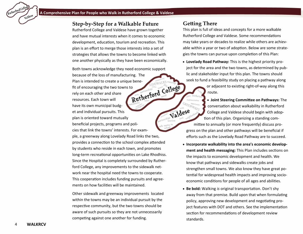
Step-by-Step for a Walkable Future Rutherford College and Valdese have grown together
and have mutual interests when it comes to economic
development, education, tourism and recreation. This
plan is an effort to merge those interests into a set of
strategies that allows the towns to become linked with
one another physically as they have been economically.
Both towns acknowledge they need economic support
because of the loss of manufacturing. The
Plan is intended to create a unique bene-
fit of encouraging the two towns to
rely on each other and share
resources. Each town will
have its own municipal budg-
et and individual pursuits. This
plan is oriented toward mutually
beneficial projects, programs and poli-
cies that link the towns’ interests. For exam-
ple, a greenway along Lovelady Road links the two,
provides a connection to the school complex attended
by students who reside in each town, and promotes
long-term recreational opportunities on Lake Rhodhiss.
Since the Hospital is completely surrounded by Ruther-
ford College, any improvements to the sidewalk net-
work near the hospital need the towns to cooperate.
This cooperation includes funding pursuits and agree-
ments on how facilities will be maintained.
Other sidewalk and greenway improvements located
within the towns may be an individual pursuit by the
respective community, but the two towns should be
aware of such pursuits so they are not unnecessarily
competing against one another for funding.
Getting There This plan is full of ideas and concepts for a more walkable
Rutherford College and Valdese. Some recommendations
may take years or decades to realize while others are achiev-
able within a year or two of adoption. Below are some strate-
gies the towns can pursue upon completion of this Plan:
Lovelady Road Pathway: This is the highest priority pro-
ject for the area and the two towns, as determined by pub-
lic and stakeholder input for this plan. The towns should
seek to fund a feasibility study on placing a pathway along
or adjacent to existing right-of-way along this
route.
Joint Steering Committee on Pathways: The
conversation about walkability in Rutherford
College and Valdese should begin with adop-
tion of this plan. Organizing a standing com-
mittee to annually (or more frequently) discuss pro-
gress on the plan and other pathways will be beneficial if
efforts such as the Lovelady Road Pathway are to succeed.
Incorporate walkability into the area’s economic develop-
ment and health messaging: This Plan includes sections on
the impacts to economic development and health. We
know that pathways and sidewalks create jobs and
strengthen small towns. We also know they have great po-
tential for widespread health impacts and improving socio-
economic conditions for people of all ages and abilities.
Be bold: Walking is original transportation. Don’t shy
away from that premise. Build upon that when formulating
policy, approving new development and negotiating pro-
ject features with DOT and others. See the implementation
section for recommendations of development review
standards.
WALKRCV 5
Chapter 2 Building the Plan Chapter 2 Building the Plan
"Well-considered planning must bear in mind not only the importance of local and regional circumstance...but the more impalpable elements of tradition, historical character and social custom.” - John Nolen, New Towns for Old
6 WALKRCV
A Comprehensive Plan for People who Walk in Rutherford College & Valdese
Building the Plan Those who walk the community, manage its businesses
and administer the Towns business know the communi-
ty best. Any good Plan is built from input from these and
other key individuals and organizations. The corner-
stone of Walk RCV is the public/stakeholder input and
what is known about the town through analysis of de-
mographic data.
The efforts to build the plan consisted
of a multi-pronged approach to spread
awareness of the planning process and
ensure a variety of local perspectives
were incorporated into the plan. Resi-
dents, key stakeholders, and town staff
were engaged during the planning pro-
cess through the following channels:
Steering Committee Meetings;
Public Meetings and Outreach
Events;
Public Input Survey; and
Interactive Map.
Finally, a brief analysis of Census data was compiled to
provide a snapshot of prevailing demographic data and
conditions across Rutherford College and Valdese.
Steering Committee The process for the Plan was overseen by a Steering
Committee comprised of representatives from both
Towns, the County, the business community, pedestrian
and health advocacy organizations, and several interest-
ed town residents. The Steering Committee convened
on four occasions to provide input on pedestrian issues
and opportunities, to serve as a sounding board for elements
of the planning process, and to review plan deliverables.
The first Steering Committee meeting was held in July 2015
at Valdese Town Hall. The consultant team gathered feed-
back about important pedestrian destinations and hotspots
in the Town to be evaluated by the consultant team.
The second Steering Committee meeting was held concur-
rently with the Public Workshops at Rutherford College Town
Hall and the Old Rock School in Valdese. The meetings were
used to gather input from stakeholders on locations for pe-
destrian facility improvements that would help connect peo-
ple with popular destinations.
Members of the steering committee met for the third time in
October 2015 in Rutherford College. Participants provided
edits on the draft plan chapters as well as the results of the
most popular projects identified through the community en-
gagement process. The participants rated the relative im-
portance of different types of pedestrian placemaking and
land use and development strategies to help identify critera
to rank projects (Appendix B, page 98).
The steering committee members assigned their final bonus
points to the project rankings at the final meeting in Febru-
ary 2016. They also reviewed the other elements of the
working paper and approved the plan to be forwarded to
NCDOT's Bicycle and Pedestrian Transportation Planning divi-
sion for final review and endorsement.
Public Meetings and Outreach Events Valdese’s Waldensian Festival. In August 2015 the consult-
ant team set up an informational booth at the downtown
Waldensian Festival to raise awareness about the pedestrian
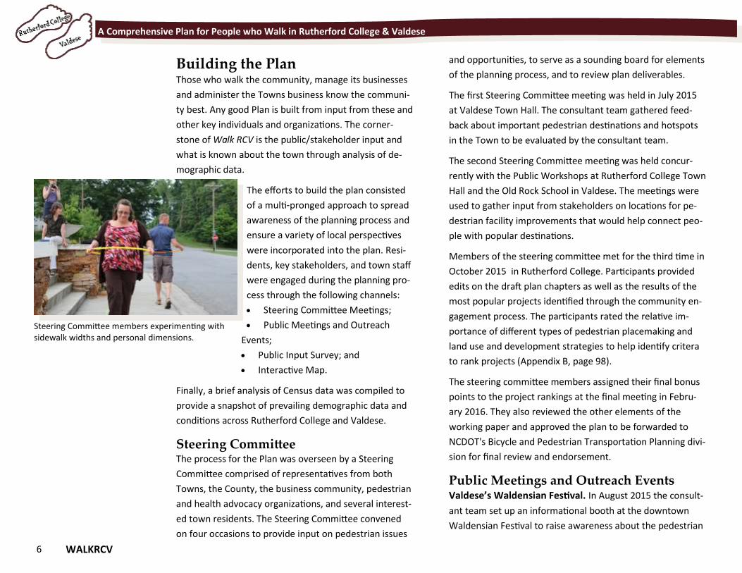
Steering Committee members experimenting with sidewalk widths and personal dimensions.
WALKRCV 7
A Comprehensive Plan for People who Walk in Rutherford College & Valdese
plan and encourage participation in the public input survey.
To attract more survey respondents, a raffle was held and
those who completed the survey had the opportunity to win
a bottle of wine from the local vineyard. In total, 23 individ-
uals completed the survey during the festival.
Rutherford College Fall Festival. In October 2015 the con-
sultant team set up an informational booth at the Town of
Rutherford College Fall Festival to raise awareness about the
pedestrian plan and encourage participation in the public
input survey. Overall attendance was lower than in previous
years due to Festival having been rescheduled and the chilly
weather, but many residents stopped by to view the plan
and ask questions. In total, 12 individuals completed the
survey during the festival and several others wrote com-
ments directly on the map.
Public Workshops Two public workshops were held on August 31, 2015 at the
Old Rock School in Valdese and September 1 at Rutherford
College’s Town Hall. The purpose of these was to collect in-
put from Town residents and stakeholders on popular desti-
nations in Rutherford College and Valdese as well as pedes-
trian network improvements that would make walking to
these locations safer and more convenient. The workshop
was advertised through notices on the radio, posts on both
Towns’ websites and their Facebook pages, Valdese’s Recre-
ation and Friends of Valdese Rec’s Facebook Pages, email
lists for both Towns’ boards and community organizations,
emails from local residents and organizations collected dur-
ing Plan outreach efforts, and announcements at other
Town meetings.
The meetings were opened with a presentation by the
consultant that included an overview of the plan purpose
and timeline, a review of basic pedestrian planning con-
cepts, and preliminary findings from field research in the
Town. Meeting attendees were then divided into groups
for a mapping exercise. Each group identified places that
they would like to walk, and then highlighted gaps in the
pedestrian network where construction or improvement
projects were needed for sidewalks, greenways and in-
tersections.
The groups presented their top five
pedestrian projects, and common
themes that emerged from the exer-
cise were used as the basis for a facili-
tated discussion that concluded the
workshop. Map markups, projects, and
discussion topics from the workshop
were used to help formulate recom-
mendations in the Plan. Approximately
12 people joined the first evening and
eight on the second. Although there was not a large turn-
out, individuals provided thoughtful and relevant input
on these potential pedestrian improvements.
Open House The final set of Open Houses occurred December 15,
2015 in Valdese and Rutherford College’s Town Halls. A
set of five display boards were placed around the room,
and residents could drop in, learn more about the out-
comes of the plan, and vote for their most important
projects. Individuals were encouraged to vote for their
favorite pedestrian amenities, such as picnic facilities,
Walk your Town signs, and public water fountains. Sev-
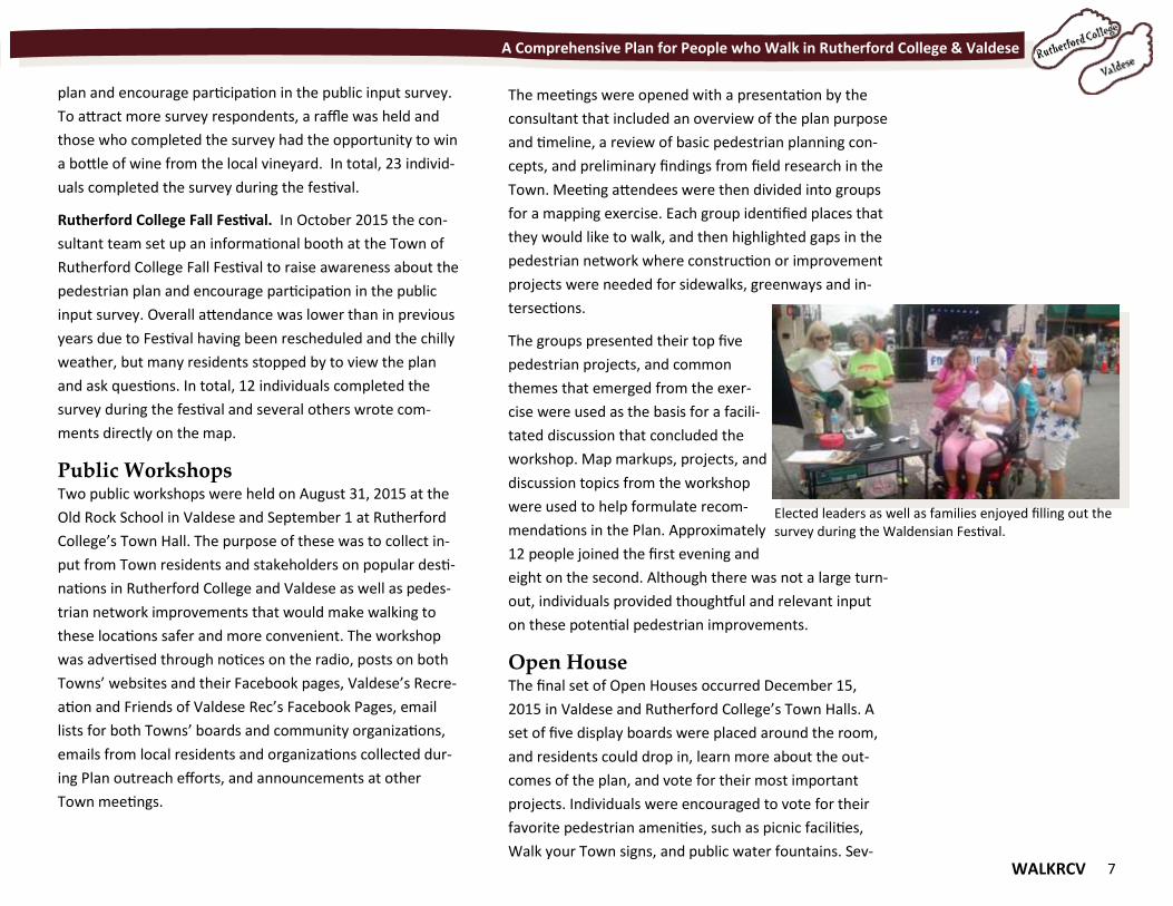
Elected leaders as well as families enjoyed filling out the survey during the Waldensian Festival.
8 WALKRCV
A Comprehensive Plan for People who Walk in Rutherford College & Valdese
enteen (17) people attended the meetings. The consult-
ant team used the input from this meeting to refine the
final version of the plan.
Public Input Survey A public input survey was deployed to col-
lect additional input from local residents on
their walking habits, popular destinations,
barriers to walking, and needed improve-
ments to the pedestrian network. A link to
the online survey was posted on both
Towns websites and Facebook pages, and in
the local newspaper. A link to the survey
was also emailed to Town staff, Town
boards, community organizations and clubs
for further distribution. Hard copies of the
survey were made available at public loca-
tions such as Town Halls and at events such
as the Waldensian Festival and Rutherford
College’s Fall Festival.
The survey was open for five months from
June to October, during which 132 online and printed
responses were collected. A summary and analysis of
the results from the public input survey are included in
several exhibits on the following pages.
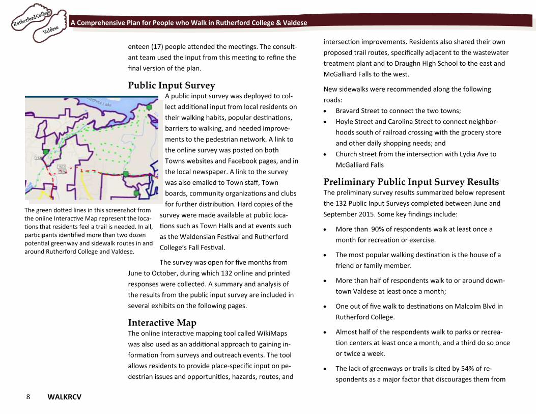
Interactive Map The online interactive mapping tool called WikiMaps
was also used as an additional approach to gaining in-
formation from surveys and outreach events. The tool
allows residents to provide place-specific input on pe-
destrian issues and opportunities, hazards, routes, and
intersection improvements. Residents also shared their own
proposed trail routes, specifically adjacent to the wastewater
treatment plant and to Draughn High School to the east and
McGalliard Falls to the west.
New sidewalks were recommended along the following
roads:
Bravard Street to connect the two towns;
Hoyle Street and Carolina Street to connect neighbor-
hoods south of railroad crossing with the grocery store
and other daily shopping needs; and
Church street from the intersection with Lydia Ave to
McGalliard Falls
Preliminary Public Input Survey Results The preliminary survey results summarized below represent
the 132 Public Input Surveys completed between June and
September 2015. Some key findings include:
More than 90% of respondents walk at least once a
month for recreation or exercise.
The most popular walking destination is the house of a
friend or family member.
More than half of respondents walk to or around down-
town Valdese at least once a month;
One out of five walk to destinations on Malcolm Blvd in
Rutherford College.
Almost half of the respondents walk to parks or recrea-
tion centers at least once a month, and a third do so once
or twice a week.
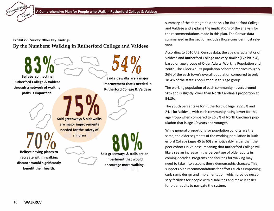
The lack of greenways or trails is cited by 54% of re-
spondents as a major factor that discourages them from
The green dotted lines in this screenshot from the online Interactive Map represent the loca-tions that residents feel a trail is needed. In all, participants identified more than two dozen potential greenway and sidewalk routes in and around Rutherford College and Valdese.
WALKRCV 9
A Comprehensive Plan for People who Walk in Rutherford College & Valdese
walking; the lack of sidewalks is cited by just 39% of re-
spondents as a major factor.
A similar proportion of respondents (35%) cited a lack of
destinations within walking distance as a major factor.
Lack of street lighting is a major factor for 25% of re-
spondents.
Among survey participants, a majority of respondents live in
2-person households and slightly more than 1 in 4 respond-
ents live with household members under the age of 18.
More than half of respondents are between the ages of 45
and 64 and women were two-thirds of survey respondents.
Other results are summarized in Exhibits 2-1, 2-2 and 2-3.
Valdese residents make up 71% of respondents while Ruth-
erford College residents make up 18% of respondents. Val-
dese has a population of 4,490 and represents approximate-
ly 77% of the population area evaluated by this plan; Ruther-
ford College has a population of 1,341 and represents 23%
of the population area. People who work in Valdese or Ruth-
erford College represent 31% of respondents.
Demographics In addition to surveys, it is important to examine a commu-
nity’s demographics as part of evaluating walking and walka-
bility because demographic information provides valuable
clues about travel behavior, preferences and can identify
potential health-related concerns as they relate to the socio-
economic conditions in which someone is raised and/or
lives.
Characteristics such as age, income, vehicle ownership, and
commute time can suggest a population’s potential for walk-
ing as a mode of transportation. This section provides a
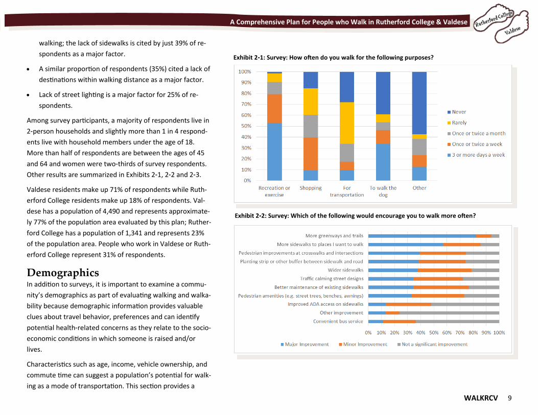
Exhibit 2-1: Survey: How often do you walk for the following purposes?
Exhibit 2-2: Survey: Which of the following would encourage you to walk more often?
10 WALKRCV
A Comprehensive Plan for People who Walk in Rutherford College & Valdese
Exhibit 2-3: Survey: Other Key Findings
summary of the demographic analysis for Rutherford College
and Valdese and explains the implications of the analysis for
the recommendations made in this plan. The Census data
summarized in this section includes those consider most rele-
vant.
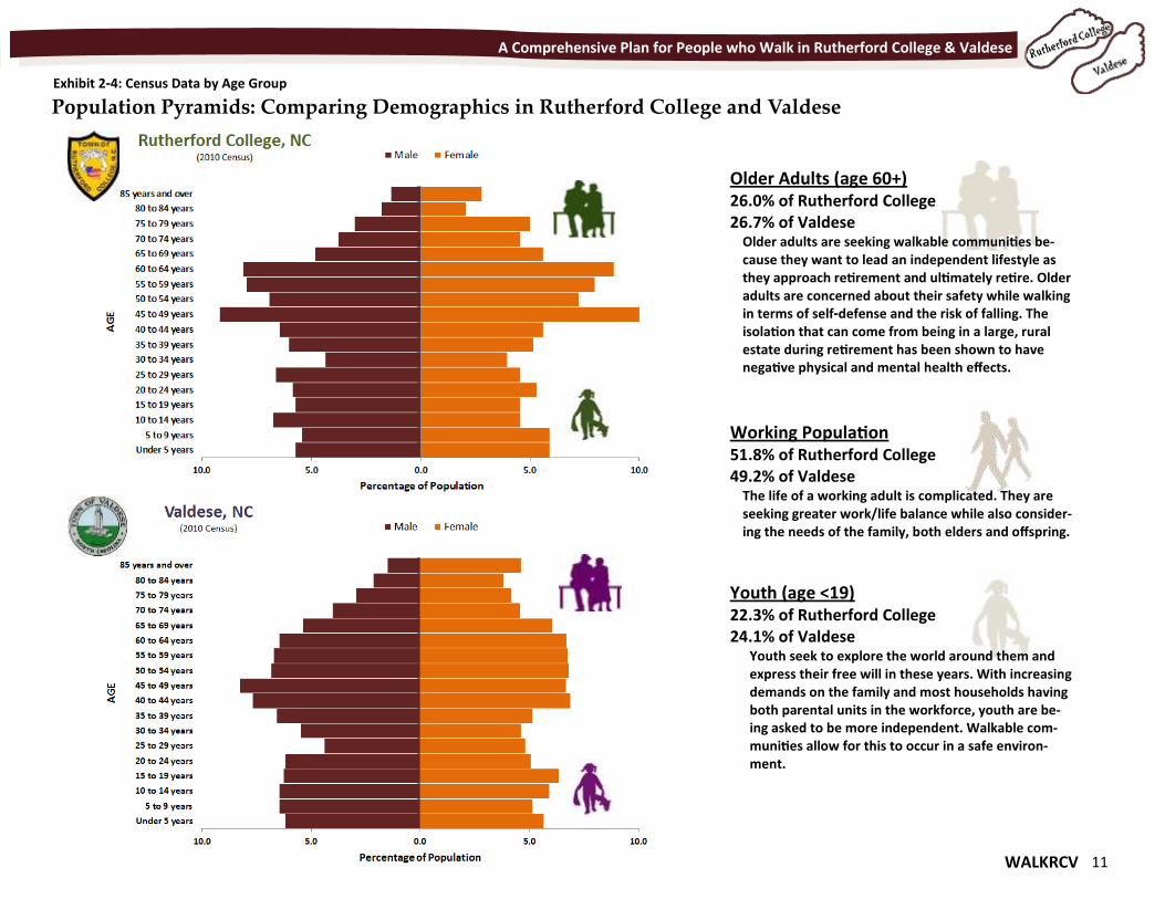
According to 2010 U.S. Census data, the age characteristics of
Valdese and Rutherford College are very similar (Exhibit 2-4),
based on age groups of Older Adults, Working Population and
Youth. The Older Adults population cohort comprises roughly
26% of the each town's overall population compared to only
18.4% of the state’s population in this age group.
The working population of each community hovers around
50% and is slightly lower than North Carolina’s proportion at
54.8%.
The youth percentage for Rutherford College is 22.3% and
24.1 for Valdese, with each community rating lower for this
age group when compared to 26.8% of North Carolina’s pop-
ulation that is age 19 years and younger.
While general proportions for population cohorts are the
same, the older segments of the working population in Ruth-
erford College (ages 45 to 60) are noticeably larger than their
peer cohorts in Valdese, meaning that Rutherford College will
likely see an increase in the percentage of older adults in
coming decades. Programs and facilities for walking may
need to take into account these demographic changes. This
supports plan recommendations for efforts such as improving
curb ramp design and implementation, which provide neces-
sary facilities for people with disabilities and make it easier
for older adults to navigate the system.
By the Numbers: Walking in Rutherford College and Valdese
Believe connecting
Rutherford College & Valdese
through a network of walking
paths is important.
Said sidewalks are a major
improvement that’s needed in
Rutherford College & Valdese
Said greenways & sidewalks
are major improvements
needed for the safety of
children
Believe having places to
recreate within walking
distance would significantly
benefit their health.
Said greenways & trails are an
investment that would
encourage more walking.
WALKRCV 11
A Comprehensive Plan for People who Walk in Rutherford College & Valdese
Older Adults (age 60+) 26.0% of Rutherford College 26.7% of Valdese
Older adults are seeking walkable communities be-cause they want to lead an independent lifestyle as they approach retirement and ultimately retire. Older adults are concerned about their safety while walking in terms of self-defense and the risk of falling. The isolation that can come from being in a large, rural estate during retirement has been shown to have negative physical and mental health effects.
Youth (age <19) 22.3% of Rutherford College 24.1% of Valdese
Youth seek to explore the world around them and express their free will in these years. With increasing demands on the family and most households having both parental units in the workforce, youth are be-ing asked to be more independent. Walkable com-munities allow for this to occur in a safe environ-ment.
Working Population 51.8% of Rutherford College 49.2% of Valdese
The life of a working adult is complicated. They are seeking greater work/life balance while also consider-ing the needs of the family, both elders and offspring.
Exhibit 2-4: Census Data by Age Group
Population Pyramids: Comparing Demographics in Rutherford College and Valdese
12 WALKRCV
A Comprehensive Plan for People who Walk in Rutherford College & Valdese
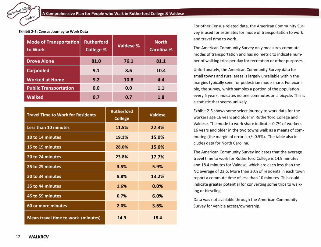
For other Census-related data, the American Community Sur-
vey is used for estimates for mode of transportation to work
and travel time to work.
The American Community Survey only measures commute
modes of transportation and has no metric to indicate num-
ber of walking trips per day for recreation or other purposes.
Unfortunately, the American Community Survey data for
small towns and rural areas is largely unreliable within the
margins typically seen for pedestrian mode share. For exam-
ple, the survey, which samples a portion of the population
every 5 years, indicates no one commutes on a bicycle. This is
a statistic that seems unlikely.
Exhibit 2-5 shows some select journey to work data for the
workers age 16 years and older in Rutherford College and
Valdese. The mode to work share indicates 0.7% of workers
16 years and older in the two towns walk as a means of com-
muting (the margin of error is +/- 0.5%). The table also in-
cludes data for North Carolina.
The American Community Survey indicates that the average
travel time to work for Rutherford College is 14.9 minutes
and 18.4 minutes for Valdese, which are each less than the
NC average of 23.6. More than 30% of residents in each town
report a commute time of less than 10 minutes. This could
indicate greater potential for converting some trips to walk-
ing or bicycling.
Data was not available through the American Community
Survey for vehicle access/ownership.
Mode of Transportation
to Work
Rutherford
College % Valdese %
North
Carolina %
Drove Alone 81.0 76.1 81.1
Carpooled 9.1 8.6 10.4
Worked at Home 9.2 10.8 4.4
Public Transportation 0.0 0.0 1.1
Walked 0.7 0.7 1.8
Travel Time to Work for Residents Rutherford
College Valdese
Less than 10 minutes 11.5% 22.3%
10 to 14 minutes 19.1% 15.0%
15 to 19 minutes 28.0% 15.6%
20 to 24 minutes 23.8% 17.7%
25 to 29 minutes 3.5% 5.9%
30 to 34 minutes 9.8% 13.2%
35 to 44 minutes 1.6% 0.0%
45 to 59 minutes 0.7% 6.0%
60 or more minutes 2.0% 3.6%
Mean travel time to work (minutes) 14.9 18.4
Exhibit 2-5: Census Journey to Work Data
WALKRCV 13
Chapter 3 Walk This Way Chapter 3 Walk This Way
"If you go to a place on anything but your own feet you are taken there too fast, and miss a thousand delicate joys that were waiting for you by the wayside.” - Elizabeth von Arnim, The Adventures of Elizabeth in Rügen
14 WALKRCV
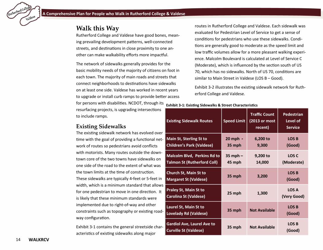
A Comprehensive Plan for People who Walk in Rutherford College & Valdese
Walk this Way Rutherford College and Valdese have good bones, mean-
ing prevailing development patterns, well-connected
streets, and destinations in close proximity to one an-
other can make walkability efforts more impactful.
The network of sidewalks generally provides for the
basic mobility needs of the majority of citizens on foot in
each town. The majority of main roads and streets that
connect neighborhoods to destinations have sidewalks
on at least one side. Valdese has worked in recent years
to upgrade or install curb ramps to provide better access
for persons with disabilities. NCDOT, through its
resurfacing projects, is upgrading intersections
to include ramps.
Existing Sidewalks The existing sidewalk network has evolved over
time with the goal of providing a functional net-
work of routes so pedestrians avoid conflicts
with motorists. Many routes outside the down-
town core of the two towns have sidewalks on
one side of the road to the extent of what was
the town limits at the time of construction.
These sidewalks are typically 4-feet or 5-feet in
width, which is a minimum standard that allows
for one pedestrian to move in one direction. It
is likely that these minimum standards were
implemented due to right-of-way and other
constraints such as topography or existing road-
way configuration.
Exhibit 3-1 contains the general streetside char-
acteristics of existing sidewalks along major
routes in Rutherford College and Valdese. Each sidewalk was
evaluated for Pedestrian Level of Service to get a sense of
conditions for pedestrians who use these sidewalks. Condi-
tions are generally good to moderate as the speed limit and
low traffic volumes allow for a more pleasant walking experi-
ence. Malcolm Boulevard is calculated at Level of Service C
(Moderate), which is influenced by the section south of US
70, which has no sidewalks. North of US 70, conditions are
similar to Main Street in Valdese (LOS B – Good).
Exhibit 3-2 illustrates the existing sidewalk network for Ruth-
erford College and Valdese.
Existing Sidewalk Routes Speed Limit
Traffic Count
(2013 or most
recent)
Pedestrian
Level of
Service
Main St, Sterling St to
Children’s Park (Valdese)
20 mph -
35 mph
6,200 to
9,300
LOS B
(Good)
Malcolm Blvd, Perkins Rd to
Talmon St (Rutherford Coll)
35 mph –
45 mph
9,200 to
14,000
LOS C
(Moderate)
Church St, Main St to
Margaret St (Valdese) 35 mph 3,200
LOS B
(Good)
Praley St, Main St to
Carolina St (Valdese) 25 mph 1,300
LOS A
(Very Good)
Laurel St, Main St to
Lovelady Rd (Valdese) 35 mph Not Available
LOS B
(Good)
Gardiol Ave, Laurel Ave to
Curville St (Valdese) 35 mph Not Available
LOS B
(Good)
Exhibit 3-1: Existing Sidewalks & Street Characteristics
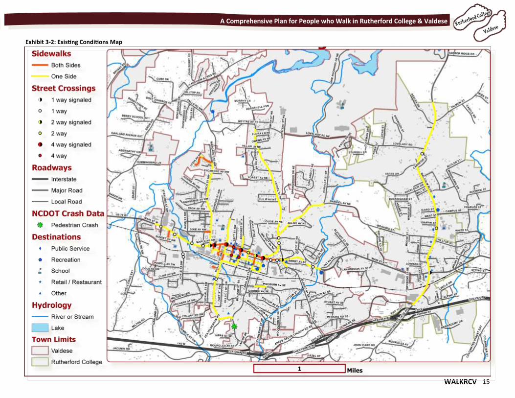
WALKRCV 15
A Comprehensive Plan for People who Walk in Rutherford College & Valdese
Exhibit 3-2: Existing Conditions Map
16 WALKRCV
A Comprehensive Plan for People who Walk in Rutherford College & Valdese
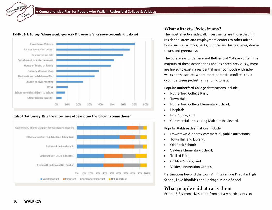
What attracts Pedestrians? The most effective sidewalk investments are those that link
residential areas and employment centers to other attrac-
tions, such as schools, parks, cultural and historic sites, down-
towns and greenways.
The core areas of Valdese and Rutherford College contain the
majority of these destinations and, as noted previously, most
are linked to existing residential neighborhoods with side-
walks on the streets where more potential conflicts could
occur between pedestrians and motorists.
Popular Rutherford College destinations include:
Rutherford College Park;
Town Hall;
Rutherford College Elementary School;
Hospital;
Post Office; and
Commercial areas along Malcolm Boulevard.
Popular Valdese destinations include:
Downtown & nearby commercial, public attractions;
Town Hall and Library;
Old Rock School;
Valdese Elementary School;
Trail of Faith;
Children’s Park; and
Valdese Recreation Center.
Destinations beyond the towns’ limits include Draughn High
School, Lake Rhodhiss and Heritage Middle School.
What people said attracts them Exhibit 3-3 summarizes input from survey participants on
Exhibit 3-3: Survey: Where would you walk if it were safer or more convenient to do so?
Exhibit 3-4: Survey: Rate the importance of developing the following connections?
WALKRCV 17
A Comprehensive Plan for People who Walk in Rutherford College & Valdese
where they would walk if it were safer or more convenient.
Some highlights include:
More than 70% of respondents would walk to Down-
town Valdese more often if walking were safer and
more convenient.
Two thirds would walk more often to parks or recrea-
tion centers.
Other popular walking destinations included restaurants
or café and social event or entertainment.
33% of respondents would walk more often to destina-
tions on Malcolm Blvd.
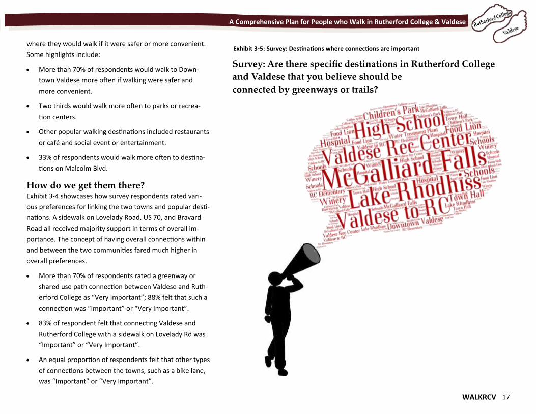
How do we get them there? Exhibit 3-4 showcases how survey respondents rated vari-
ous preferences for linking the two towns and popular desti-
nations. A sidewalk on Lovelady Road, US 70, and Bravard
Road all received majority support in terms of overall im-
portance. The concept of having overall connections within
and between the two communities fared much higher in
overall preferences.
More than 70% of respondents rated a greenway or
shared use path connection between Valdese and Ruth-
erford College as “Very Important”; 88% felt that such a
connection was “Important” or “Very Important”.
83% of respondent felt that connecting Valdese and
Rutherford College with a sidewalk on Lovelady Rd was
“Important” or “Very Important”.
An equal proportion of respondents felt that other types
of connections between the towns, such as a bike lane,
was “Important” or “Very Important”.
Survey: Are there specific destinations in Rutherford College
and Valdese that you believe should be
connected by greenways or trails?
Exhibit 3-5: Survey: Destinations where connections are important
18 WALKRCV
A Comprehensive Plan for People who Walk in Rutherford College & Valdese
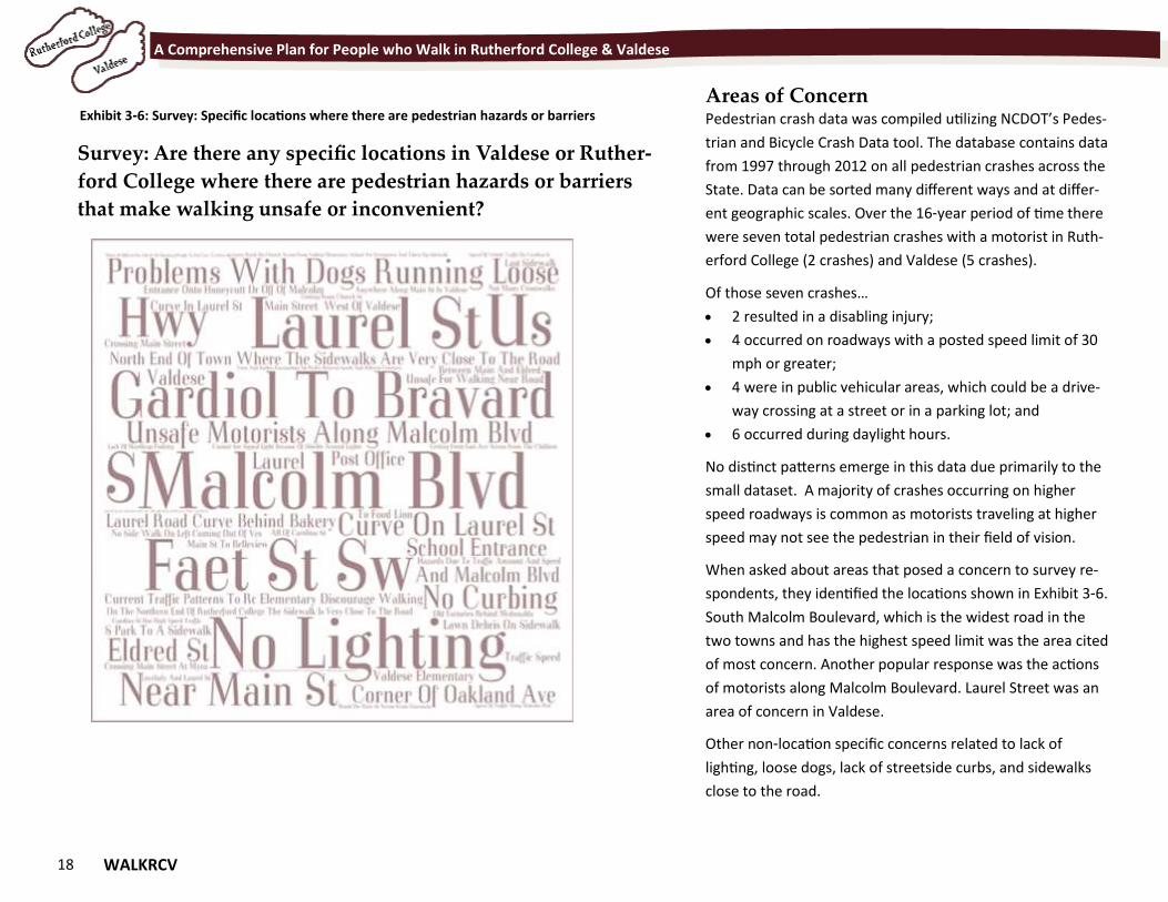
Areas of Concern Pedestrian crash data was compiled utilizing NCDOT’s Pedes-
trian and Bicycle Crash Data tool. The database contains data
from 1997 through 2012 on all pedestrian crashes across the
State. Data can be sorted many different ways and at differ-
ent geographic scales. Over the 16-year period of time there
were seven total pedestrian crashes with a motorist in Ruth-
erford College (2 crashes) and Valdese (5 crashes).
Of those seven crashes…
2 resulted in a disabling injury;
4 occurred on roadways with a posted speed limit of 30
mph or greater;
4 were in public vehicular areas, which could be a drive-
way crossing at a street or in a parking lot; and
6 occurred during daylight hours.
No distinct patterns emerge in this data due primarily to the
small dataset. A majority of crashes occurring on higher
speed roadways is common as motorists traveling at higher
speed may not see the pedestrian in their field of vision.
When asked about areas that posed a concern to survey re-
spondents, they identified the locations shown in Exhibit 3-6.
South Malcolm Boulevard, which is the widest road in the
two towns and has the highest speed limit was the area cited
of most concern. Another popular response was the actions
of motorists along Malcolm Boulevard. Laurel Street was an
area of concern in Valdese.
Other non-location specific concerns related to lack of
lighting, loose dogs, lack of streetside curbs, and sidewalks
close to the road.
Exhibit 3-6: Survey: Specific locations where there are pedestrian hazards or barriers
Survey: Are there any specific locations in Valdese or Ruther-
ford College where there are pedestrian hazards or barriers
that make walking unsafe or inconvenient?
WALKRCV 19
Chapter 4 Walking the Walk Chapter 4 Walking the Walk
"Everywhere is within walking distance if you have the time." - Steven Wright
20 WALKRCV
A Comprehensive Plan for People who Walk in Rutherford College & Valdese
Walking the Walk Fueled by the booming economy in the post-World
War II era, planners and decision makers implement-
ed zoning ordinances, development regulations, and
transportation policies that prioritized the needs of
automobiles at the expense of pedestrians and other
non-motorized travelers. As we separated our land
uses and built bigger roads and parking lots, we lost
the connectivity between our homes and our schools
and we increased the distance between our office and
the grocery store. We made it difficult to navigate
from place to place by anything other than a car.
The Town of Valdese was not immune to this
type of land development pattern; nor was the
Town of Rutherford College whose original land
use pattern was shaped by a college campus. In
both towns, pedestrian mobility was central to
town life.
Each town’s development activity shifted away
from traditional neighborhood/campus devel-
opment patterns near the in-town neighbor-
hoods to auto-oriented development patterns
along today’s busy roads such as US 70 where
there was an adequate land supply to accom-
modate large parking lots and wide roads.
In Valdese, old schools nearer to downtown neighbor-
hoods were closed or repurposed when larger, less ac-
cessible schools opened. Fortunately for Rutherford Col-
lege, the walkable Rutherford College Elementary
School still serves the nearby neighborhoods.
However, Rutherford College and Valdese are on a path
of change. With recent projects and plans, the Towns are tak-
ing steps to reestablish pedestrian connections and improve
overall walkability.
When one views Valdese and Rutherford College’s plans as a
complete body of work, it is clear that the towns want to be-
come places that are well-connected—towns where resi-
dents can walk to the grocery store, to schools, to parks, and
to local businesses. While stating a desire or adopting a vision
is a good starting place, a vision alone cannot create a con-
nected and coordinated pedestrian network.
Communities need good policies and implementation plans
to transform their vision to on-the-ground sidewalks, safe
intersection crossings, and off-street paths. Exhibit 4-1 shows
how policy impacts walkability and these are the elements by
which existing plans were summarized.
Rutherford College and Valdese need a set of built-
environment policies (recreation facilities, neighborhood de-
sign, safety, aesthetics, facilities, destinations to walk to, poli-
cies that influence land use and transportation systems) that
result in features that facilitate walking. This section of
WalkRCV evaluates each town’s built-environment policies.
The Plans evaluated for this include:
Rutherford College & Valdese Land Use Plans;
Valdese Vision;
Valdese Recreation Plan;
Valdese Main Street Plans;
Regional Transportation Plan;
GHMPO Long Range Transportation Plan;
Locally Administered Project Program (LAPP);
Western Piedmont Regional Bike Plan; and
Zoning ordinances
More than a dozen existing plans and policies for Rutherford College, Valdese and the region were reviewed to identify themes related to walkability.
WALKRCV 21
A Comprehensive Plan for People who Walk in Rutherford College & Valdese
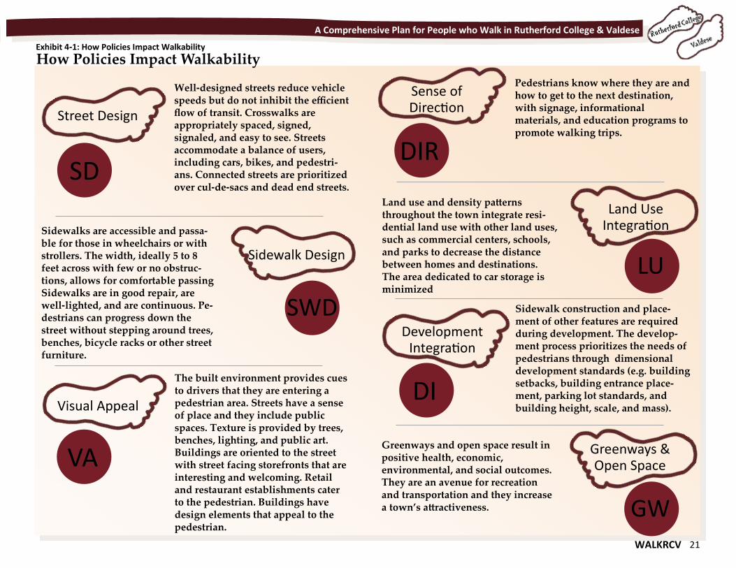
How Policies Impact Walkability Exhibit 4-1: How Policies Impact Walkability
Street Design
Well-designed streets reduce vehicle speeds but do not inhibit the efficient flow of transit. Crosswalks are appropriately spaced, signed, signaled, and easy to see. Streets accommodate a balance of users, including cars, bikes, and pedestri-ans. Connected streets are prioritized over cul-de-sacs and dead end streets.
Sidewalk Design
Sidewalks are accessible and passa-ble for those in wheelchairs or with strollers. The width, ideally 5 to 8 feet across with few or no obstruc-tions, allows for comfortable passing Sidewalks are in good repair, are well-lighted, and are continuous. Pe-destrians can progress down the street without stepping around trees, benches, bicycle racks or other street furniture.
SD
SWD
Visual Appeal
The built environment provides cues to drivers that they are entering a pedestrian area. Streets have a sense of place and they include public spaces. Texture is provided by trees, benches, lighting, and public art. Buildings are oriented to the street with street facing storefronts that are interesting and welcoming. Retail and restaurant establishments cater to the pedestrian. Buildings have design elements that appeal to the pedestrian.
VA
Sense of Direction
Pedestrians know where they are and how to get to the next destination, with signage, informational materials, and education programs to promote walking trips.
Land Use Integration
Land use and density patterns throughout the town integrate resi-dential land use with other land uses, such as commercial centers, schools, and parks to decrease the distance between homes and destinations. The area dedicated to car storage is minimized
DIR
LU
Development Integration
DI
Greenways & Open Space
Greenways and open space result in positive health, economic, environmental, and social outcomes. They are an avenue for recreation and transportation and they increase a town’s attractiveness.
Sidewalk construction and place-ment of other features are required during development. The develop-ment process prioritizes the needs of pedestrians through dimensional development standards (e.g. building setbacks, building entrance place-ment, parking lot standards, and building height, scale, and mass).
GW
22 WALKRCV
A Comprehensive Plan for People who Walk in Rutherford College & Valdese
Comprehensive Plan Goals Influences on Walkability
Encourage low-impact, environmentally friendly busi-nesses, including retail, service industries, and medical
and professional offices.
Explore design related guidelines and minimum stand-ards regulating the aesthetic quality of new and existing
development.
Identify and acquire land in strategic locations to en-courage appropriate development including open space preservation, greenways, parks and other passive recre-
ation opportunities.
Preserve the community’s open spaces through density
controls and zoning and subdivision regulations
Require open space as a percentage of total acreage, in the form of shared or community open space or buffers
in new subdivisions
Determine the feasibly of a greenway through town
Explore feasibility of buried utilities down Malcolm Blvd.
& Provide more lighting
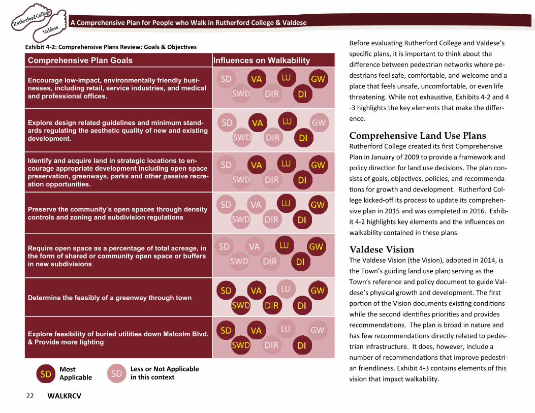
Exhibit 4-2: Comprehensive Plans Review: Goals & Objectives
Most Applicable
Less or Not Applicable in this context
Before evaluating Rutherford College and Valdese’s
specific plans, it is important to think about the
difference between pedestrian networks where pe-
destrians feel safe, comfortable, and welcome and a
place that feels unsafe, uncomfortable, or even life
threatening. While not exhaustive, Exhibits 4-2 and 4
-3 highlights the key elements that make the differ-
ence.
Comprehensive Land Use Plans Rutherford College created its first Comprehensive
Plan in January of 2009 to provide a framework and
policy direction for land use decisions. The plan con-
sists of goals, objectives, policies, and recommenda-
tions for growth and development. Rutherford Col-
lege kicked-off its process to update its comprehen-
sive plan in 2015 and was completed in 2016. Exhib-
it 4-2 highlights key elements and the influences on
walkability contained in these plans.
Valdese Vision The Valdese Vision (the Vision), adopted in 2014, is
the Town’s guiding land use plan; serving as the
Town’s reference and policy document to guide Val-
dese’s physical growth and development. The first
portion of the Vision documents existing conditions
while the second identifies priorities and provides
recommendations. The plan is broad in nature and
has few recommendations directly related to pedes-
trian infrastructure. It does, however, include a
number of recommendations that improve pedestri-
an friendliness. Exhibit 4-3 contains elements of this
vision that impact walkability.
WALKRCV 23
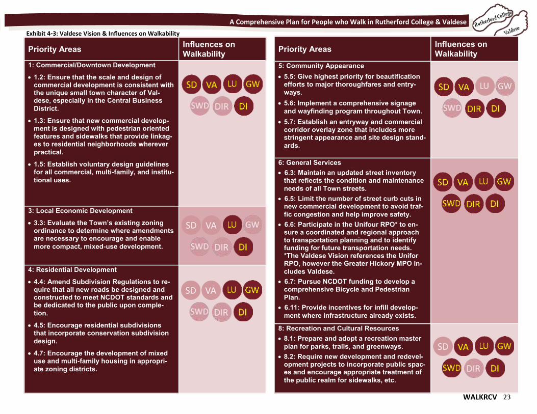
A Comprehensive Plan for People who Walk in Rutherford College & Valdese
Priority Areas Influences on
Walkability
1: Commercial/Downtown Development
1.2: Ensure that the scale and design of commercial development is consistent with the unique small town character of Val-dese, especially in the Central Business
District.
1.3: Ensure that new commercial develop-ment is designed with pedestrian oriented features and sidewalks that provide linkag-es to residential neighborhoods wherever
practical.
1.5: Establish voluntary design guidelines for all commercial, multi-family, and institu-
tional uses.
3: Local Economic Development
3.3: Evaluate the Town’s existing zoning ordinance to determine where amendments are necessary to encourage and enable
more compact, mixed-use development.
4: Residential Development
4.4: Amend Subdivision Regulations to re-quire that all new roads be designed and constructed to meet NCDOT standards and be dedicated to the public upon comple-
tion.
4.5: Encourage residential subdivisions that incorporate conservation subdivision
design.
4.7: Encourage the development of mixed use and multi-family housing in appropri-
ate zoning districts.
Priority Areas Influences on
Walkability
5: Community Appearance
5.5: Give highest priority for beautification efforts to major thoroughfares and entry-
ways.
5.6: Implement a comprehensive signage
and wayfinding program throughout Town.
5.7: Establish an entryway and commercial corridor overlay zone that includes more stringent appearance and site design stand-
ards.
6: General Services
6.3: Maintain an updated street inventory that reflects the condition and maintenance
needs of all Town streets.
6.5: Limit the number of street curb cuts in new commercial development to avoid traf-
fic congestion and help improve safety.
6.6: Participate in the Unifour RPO* to en-sure a coordinated and regional approach to transportation planning and to identify funding for future transportation needs. *The Valdese Vision references the Unifor RPO, however the Greater Hickory MPO in-
cludes Valdese.
6.7: Pursue NCDOT funding to develop a comprehensive Bicycle and Pedestrian
Plan.
6.11: Provide incentives for infill develop-
ment where infrastructure already exists.
8: Recreation and Cultural Resources
8.1: Prepare and adopt a recreation master
plan for parks, trails, and greenways.
8.2: Require new development and redevel-opment projects to incorporate public spac-es and encourage appropriate treatment of
the public realm for sidewalks, etc.
Exhibit 4-3: Valdese Vision & Influences on Walkability
24 WALKRCV
A Comprehensive Plan for People who Walk in Rutherford College & Valdese
The Valdese Vision mentions Powell Bill funds even
though it does not specifically say how the Town should
use these dollars. The Vision notes that Powell Bill funds
may be used, “for the purposes of maintaining, repair-
ing, constructing, reconstructing or widening of any
street or public thoroughfare within the municipal limits
or for planning, construction, and maintenance of
bikeways, greenways or sidewalks.” The Town should
consider adopting a policy statement or amending the
Vision to indicates strong support for the use of Powell
Bill funds for pedestrian projects.
Valdese Main
Street Plans Main Street revitaliza-
tion is a long-standing
goal for the Town of
Valdese. The Town
entered the NC-STEP Program in 2006,
which paved the way to becoming a
Small Towns Main Street Community in 2013 and a full
Main Street Community in 2015. Designated Main
Street Communities follow the National Main Street
Center’s Four-Point Approach™ of Organization, Promo-
tion, Design, and Economic Restructuring. While all four
points add to a pedestrian friendly environment, The
Walk RCV plan focuses on the Design aspects that en-
hance the pedestrian environment.
The Valdese Main Street Market Analysis (2014) is a re-
port that summarizes the Town’s market conditions and
provides direction for future downtown redevelopment
and revitalization strategies. One component of the
Market Analysis is the summary of results from a two-part
survey--an intercept survey designed to assess what consum-
ers look for in downtown Valdese and a downtown Valdese
downtown business owners survey. The survey asked con-
sumers and business owners to place a “low, high, or moder-
ate priority on possible downtown Valdese enhancements
efforts to improve the downtown area's streets, sidewalks,
lighting, furnishings, green spaces, trails, etc.” Eighty-three
percent of respondents ranked this item as a high to moder-
ate priority compared to 73% of the business owners.
Because consumers and business owners
identified these types of improvements as a
priority, the Market Analysis provided three
Design Action Steps (DAS) aimed at improving
the Town’s pedestrian environment.
In addition to the three action steps listed
above, DAS-9 addresses vehicular wayfinding
signage. It states, “Work with the Town to
improve current downtown signage, and con-
sider implementing a wayfinding signage pro-
gram including, but not limited to directional signage into
downtown from I-40 and US 70; Parking signage directing
downtown customers to public parking spaces, and to public
facilities such as Town Hall, the Museum, Old Rock School,
Police, etc.” We recommend that the Main Street Com-
mittee amend this action step to reflect the need for pedes-
trian scale wayfinding.
The Downtown Valdese Streetscape Plan is a plan to en-
hance one block of Main Street, between Rodoret Street and
Italy Street, through sidewalk, planting, and street furniture
improvements. The impetus for the streetscape came about
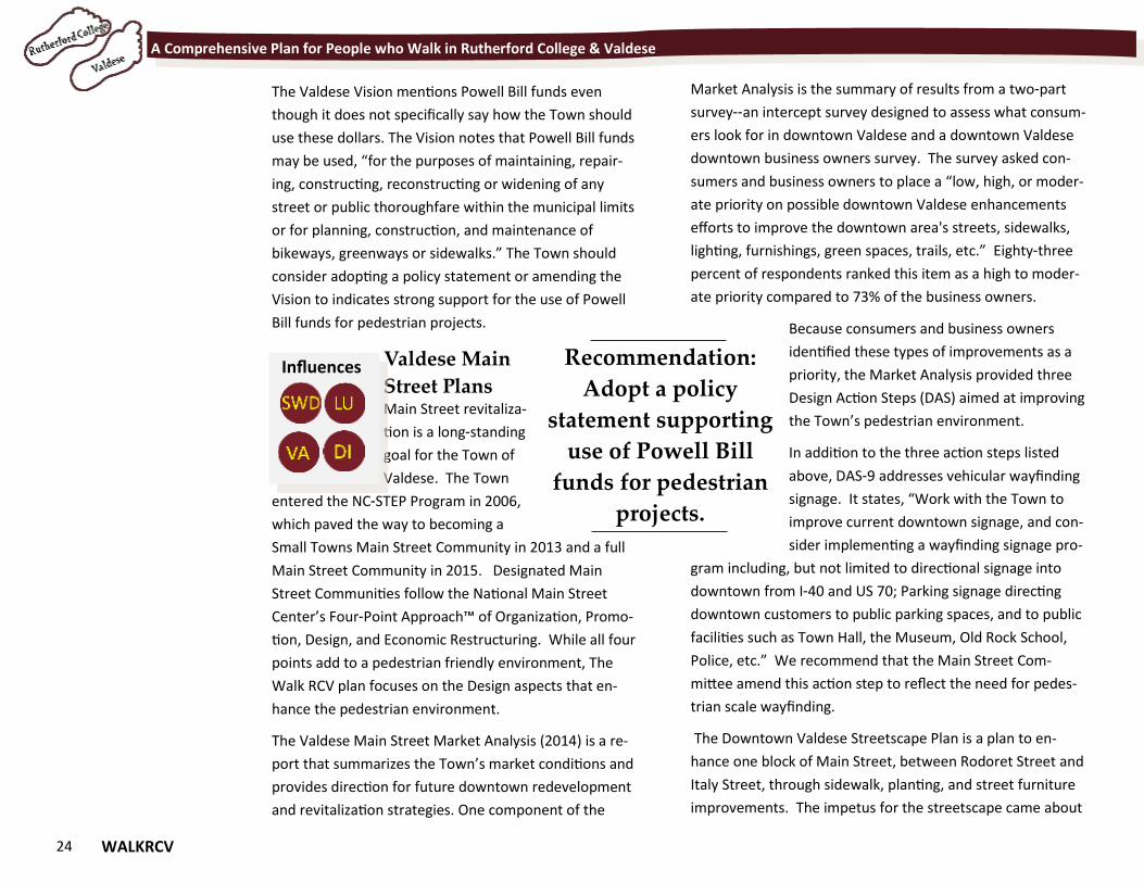
Recommendation:
Adopt a policy
statement supporting
use of Powell Bill
funds for pedestrian
projects.
Influences
WALKRCV 25
A Comprehensive Plan for People who Walk in Rutherford College & Valdese
after the Town discovered trees along the block were de-
stroying sewer lines. Repairing and replacing sewer lines
and planting new sewer-line friendly street trees requires
the Town to tear into existing infrastructure. Seeing this as
an opportunity to improve the streetscape, the Town’s Main
Street Coordinator and the Design Sub-committee worked
with a consultant to develop renderings to illustrate the
block’s potential. While plans are still conceptual, the
Downtown Valdese Streetscape Plan is a good example of
integrating pedestrian projects with infrastructure projects
(road, water, sewer, utility, and storm-
water).
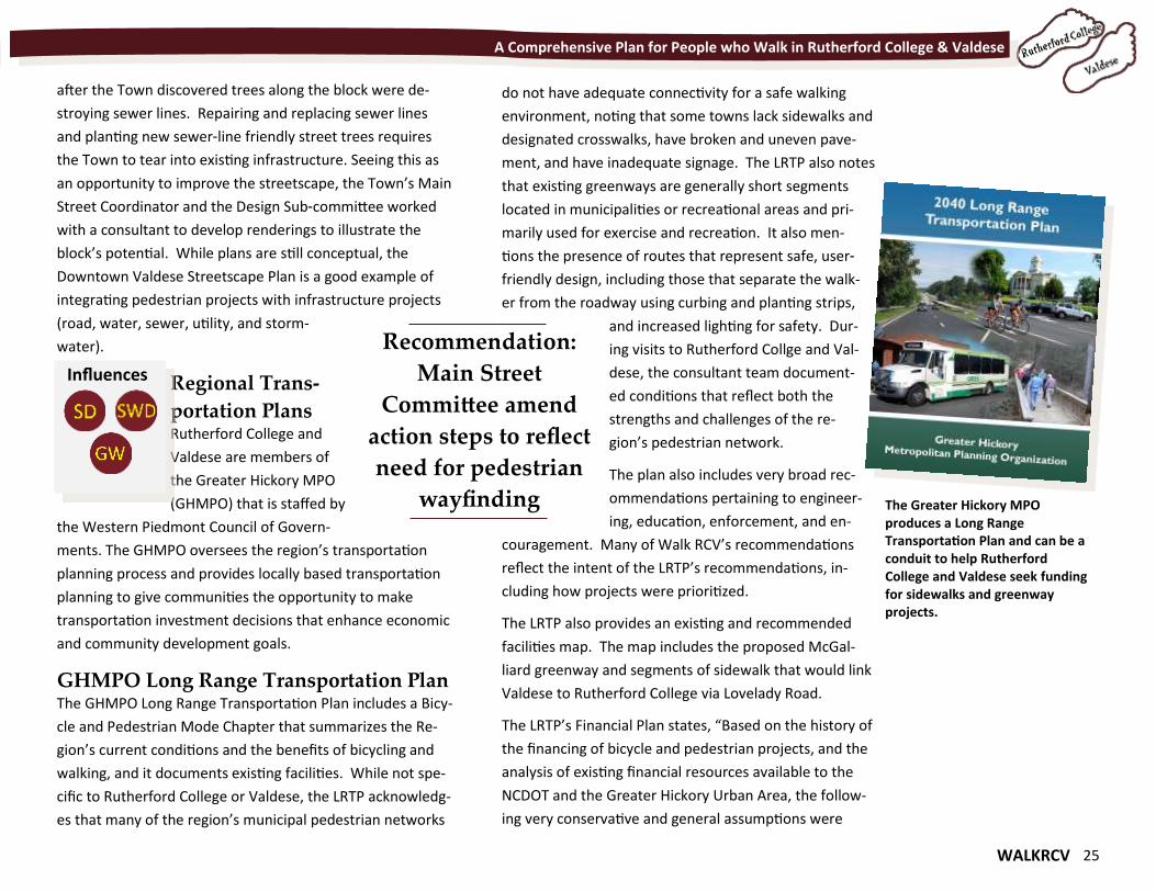
Regional Trans-
portation Plans Rutherford College and
Valdese are members of
the Greater Hickory MPO
(GHMPO) that is staffed by
the Western Piedmont Council of Govern-
ments. The GHMPO oversees the region’s transportation
planning process and provides locally based transportation
planning to give communities the opportunity to make
transportation investment decisions that enhance economic
and community development goals.
GHMPO Long Range Transportation Plan The GHMPO Long Range Transportation Plan includes a Bicy-
cle and Pedestrian Mode Chapter that summarizes the Re-
gion’s current conditions and the benefits of bicycling and
walking, and it documents existing facilities. While not spe-
cific to Rutherford College or Valdese, the LRTP acknowledg-
es that many of the region’s municipal pedestrian networks
do not have adequate connectivity for a safe walking
environment, noting that some towns lack sidewalks and
designated crosswalks, have broken and uneven pave-
ment, and have inadequate signage. The LRTP also notes
that existing greenways are generally short segments
located in municipalities or recreational areas and pri-
marily used for exercise and recreation. It also men-
tions the presence of routes that represent safe, user-
friendly design, including those that separate the walk-
er from the roadway using curbing and planting strips,
and increased lighting for safety. Dur-
ing visits to Rutherford Collge and Val-
dese, the consultant team document-
ed conditions that reflect both the
strengths and challenges of the re-
gion’s pedestrian network.
The plan also includes very broad rec-
ommendations pertaining to engineer-
ing, education, enforcement, and en-
couragement. Many of Walk RCV’s recommendations
reflect the intent of the LRTP’s recommendations, in-
cluding how projects were prioritized.
The LRTP also provides an existing and recommended
facilities map. The map includes the proposed McGal-
liard greenway and segments of sidewalk that would link
Valdese to Rutherford College via Lovelady Road.
The LRTP’s Financial Plan states, “Based on the history of
the financing of bicycle and pedestrian projects, and the
analysis of existing financial resources available to the
NCDOT and the Greater Hickory Urban Area, the follow-
ing very conservative and general assumptions were
Recommendation:
Main Street
Committee amend
action steps to reflect
need for pedestrian
wayfinding
Influences
The Greater Hickory MPO produces a Long Range Transportation Plan and can be a conduit to help Rutherford College and Valdese seek funding for sidewalks and greenway projects.
26 WALKRCV
A Comprehensive Plan for People who Walk in Rutherford College & Valdese
made to guide the development of revenue projections
through the year 2040: Funding for bicycle paths, green-
ways, sidewalks and other pedestrian facilities will con-
tinue to increase at an average of five percent (5%) an-
nually by a variety of Federal, State and local sources.”
The available dollars form bicycle and pedestrian pro-
jects will help the GHMPO achieve its Bicycle and Pedes-
trian transportation goal and policies, which state:
Goal: Create a safe effective bikeway, sidewalk, and
greenway network that is integrated with the transpor-
tation system, links together resources and destinations,
provides an alternative to automobile travel, increases
recreational opportunities, advances healthy lifestyles
and enhances the quality of life in the Greater Hickory
Area.
Policies:
Provide a pedestrian and bicycle system that allows
greater access to and links between public transit,
schools, parks and other major activity centers.
Develop a system that integrates pedestrian and
bicycle modes of travel with motor vehicle transpor-
tation, and connects inter-regionally with existing
bike and pedestrian
Increase pedestrian and bicycling activity for both
transportation and recreation to promote healthy,
active living and improve public health.
Promote, through public education, the economic,
environmental, and health benefits of walking and
biking as practical modes of transportation.
Partner with local, county, and state agencies to encour-
age bicycling and pedestrian activities across different
populations.
Recommend that new or widened roadways are designed
to include the land on each side of the road with suffi-
cient width to accommodate bicycle and pedestrian facil-
ities safely.
Encourage the delineation of safe pedestrian ways and
bicycle routes, emphasizing separation from vehicular
areas when possible.
Recommend the installation of signage when bicycle
routes and pedestrian facilities are integrated with road-
ways.
Locally Administered Projects Program The GHMPO adopted LAPP to prioritize and program regional
projects that make use of the federal funding under the pur-
view of the GHMPO. The process will involve a once-a-year
call for all local highway, transit, bicycle and pedestrian pro-
jects, and results in an annual program of projects added to
the GHMPO’s Metropolitan Transportation Improvement
Program (MTIP). Neither Rutherford College or Valdese have
current projects funded through LAPP.
Western Piedmont Regional Bike Plan The Western Piedmont Regional Bike Plan addresses on-road
bicyclist facilities and therefore does not have recommenda-
tions pertaining to Rutherford College or Valdese’s pedestri-
an environment. The one mention of trails is listed as an ob-
jective under the goal, “Encouraging Bicycle Use for Different
Purposes, Ages and Skill Levels.” The objective is to promote
WALKRCV 27
A Comprehensive Plan for People who Walk in Rutherford College & Valdese
bike trails by listing them to the “Rails to Trails” website and
publicizing trail-related events.
Valdese Recreation Plan The Valdese Recreation Plan (2013) is an assessment of cur-
rent recreation conditions, future needs and an action plan
to address those needs. Throughout the planning process,
the Town of Valdese and the Parks and Recreation Commis-
sion surveyed community members about future recreation
needs; a walking trail/greenway at McGalliard falls park con-
sistently ranked high as a need or preference. For example,
the survey summary notes, “The three most popular facili-
ties that citizens would support renovating or developing
were a walking trail/greenway at McGalliard Falls Park, ex-
panding the Valdese Recreation Center Building for Fitness
Studio/Racquetball, and replacing the pool bubble or build-
ing a permanent structure.” Likewise, the focus group sum-
mary states, “Participants wanted to see a greenway trail at
McGalliard Falls Park. Several participants said it would be
nice to have a trail so people would not have to drive to the
Morganton Greenway.” An additional item to note also
came from a focus group. Participants shared the need for a
sidewalk from Laurel Street to Lovelady Road needs to be
added to the sidewalk plan. When completed, this would
give citizens a safe route from the wastewater treatment
plant on the lake to downtown.”
Zoning Ordinances of Rutherford College
& Valdese There are many similarities between the Rutherford College
Zoning Ordinance and the Valdese Zoning Ordinance. They
have a similar structure, districts, and requirements. Both
have few standards and specifications related to the pedes-
trian environment. The most significant standards are
those that require developers to install sidewalks or pe-
destrian facilities in the Planned Unit Development sec-
tions of each ordinance. Additionally, the ordinance re-
quires public roads built in Rutherford College and Val-
dese must be built to NCDOT’s specifications and should
therefore incorporate NCDOT’s compete streets design
standards.
Exhibit 4-4 on the following page notes the primary
items from the Ordinances that shape the town’s pedes-
trian environment and provides some recommendations
for improvement.
As traditional downtowns and neighborhood develop-
ment patterns shifted from pedestrian- to auto-
orientation, towns required buildings to be farther from
the right-of-way. Traditional patterns foster interaction
between pedestrians and the built-environment; with
narrow setbacks, it is easy for the pedestrian to get from
the sidewalk to store frontages and front porches.
Wider setback distances require pedestrians to walk
longer distances, often through auto-oriented parking
lots with little to no pedestrian facilities. A zoning dis-
trict’s setback should match the intent of the district.
The districts intended to encourage walkability and con-
nection should have a narrow setback of 25 feet or less.
It should be tailored to the zoning district’s purpose and
the setback matched to the traditional development
patterns that represent more walkable features. Exhibit
4-4 chart lists each town’s zoning district, setback, and
intent.
28 WALKRCV
A Comprehensive Plan for People who Walk in Rutherford College & Valdese
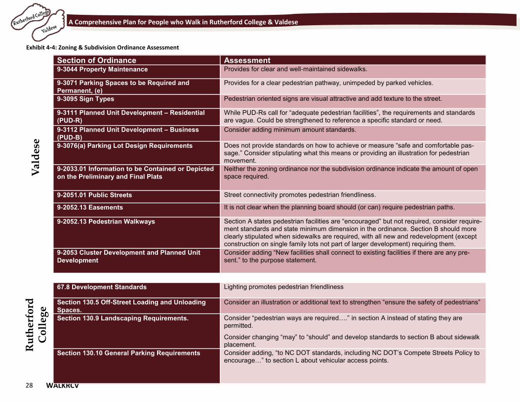
Exhibit 4-4: Zoning & Subdivision Ordinance Assessment
Section of Ordinance Assessment 9-3044 Property Maintenance Provides for clear and well-maintained sidewalks.
9-3071 Parking Spaces to be Required and
Permanent, (e) Provides for a clear pedestrian pathway, unimpeded by parked vehicles.
9-3095 Sign Types Pedestrian oriented signs are visual attractive and add texture to the street.
9-3111 Planned Unit Development – Residential
(PUD-R) While PUD-Rs call for “adequate pedestrian facilities”, the requirements and standards are vague. Could be strengthened to reference a specific standard or need.
9-3112 Planned Unit Development – Business
(PUD-B) Consider adding minimum amount standards.
9-3076(a) Parking Lot Design Requirements Does not provide standards on how to achieve or measure “safe and comfortable pas-sage.” Consider stipulating what this means or providing an illustration for pedestrian movement.
9-2033.01 Information to be Contained or Depicted
on the Preliminary and Final Plats Neither the zoning ordinance nor the subdivision ordinance indicate the amount of open space required.
9-2051.01 Public Streets Street connectivity promotes pedestrian friendliness.
9-2052.13 Easements It is not clear when the planning board should (or can) require pedestrian paths.
9-2052.13 Pedestrian Walkways Section A states pedestrian facilities are “encouraged” but not required, consider require-ment standards and state minimum dimension in the ordinance. Section B should more clearly stipulated when sidewalks are required, with all new and redevelopment (except construction on single family lots not part of larger development) requiring them.
9-2053 Cluster Development and Planned Unit
Development Consider adding “New facilities shall connect to existing facilities if there are any pre-sent.” to the purpose statement.
67.8 Development Standards Lighting promotes pedestrian friendliness
Section 130.5 Off-Street Loading and Unloading
Spaces. Consider an illustration or additional text to strengthen “ensure the safety of pedestrians”
Section 130.9 Landscaping Requirements. Consider “pedestrian ways are required….” in section A instead of stating they are permitted.
Consider changing “may” to “should” and develop standards to section B about sidewalk placement.
Section 130.10 General Parking Requirements Consider adding, “to NC DOT standards, including NC DOT’s Compete Streets Policy to encourage…” to section L about vehicular access points.
Val
des
e R
uth
erfo
rd
Co
lleg
e
WALKRCV 29
Chapter 5 The Potential of Greenways Chapter 5 The Potential of Greenways
"The enjoyment of scenery employs the mind without fatigue and yet exercises it; tranquilizes it and yet enlivens it; and thus, through the influence of the mind over the body gives the effect of refreshing rest and reinvigoration to the whole system.” - Frederick Law Olmsted
30 WALKRCV
A Comprehensive Plan for People who Walk in Rutherford College & Valdese
The Potential of Greenways Greenways are becoming a popular transportation and
recreation feature in communities across North Caroli-
na. Greenways close to Rutherford College and Valdese
include the popular Catawba River Trail in Morganton,
the Lenoir Greenway, the Hickory Greenway, and the
Lake James Loop. The Rutherford College-Valdese Pe-
destrian Plan proposes six miles of greenways. The side-
walk system would ultimately connect to these green-
way corridors providing a comprehensive pedestrian
network throughout the two towns.
This will allow any Rutherford College or
Valdese resident the ability to travel
throughout to key destinations. Visitors
will be attracted to the area and the
system will be a key recruiting and re-
tention tool to businesses and residents.
What is a greenway? A greenway is defined as a linear corri-
dor commonly built along a natural corridor such as a
river or stream or along manmade corridors such as in
utility easements, abandoned railroad beds, or adjacent
to roads. Greenways connect people and places togeth-
er such as neighborhoods, workplaces, schools, parks,
natural areas, shopping areas, and cultural attractions.
Greenway trails can be paved or unpaved, and designed
to accommodate a variety of trail users, including bicy-
clists, walkers, hikers, joggers, and wheelchair users.
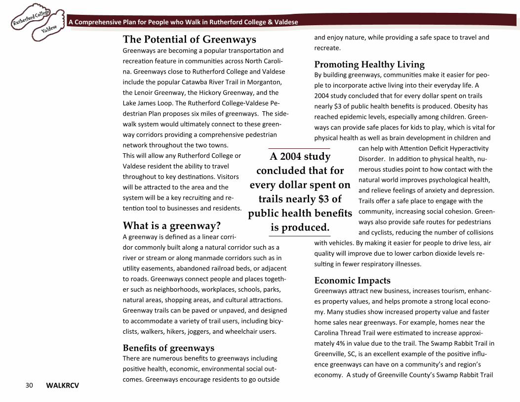
Benefits of greenways There are numerous benefits to greenways including
positive health, economic, environmental social out-
comes. Greenways encourage residents to go outside
and enjoy nature, while providing a safe space to travel and
recreate.
Promoting Healthy Living By building greenways, communities make it easier for peo-
ple to incorporate active living into their everyday life. A
2004 study concluded that for every dollar spent on trails
nearly $3 of public health benefits is produced. Obesity has
reached epidemic levels, especially among children. Green-
ways can provide safe places for kids to play, which is vital for
physical health as well as brain development in children and
can help with Attention Deficit Hyperactivity
Disorder. In addition to physical health, nu-
merous studies point to how contact with the
natural world improves psychological health,
and relieve feelings of anxiety and depression.
Trails offer a safe place to engage with the
community, increasing social cohesion. Green-
ways also provide safe routes for pedestrians
and cyclists, reducing the number of collisions
with vehicles. By making it easier for people to drive less, air
quality will improve due to lower carbon dioxide levels re-
sulting in fewer respiratory illnesses.
Economic Impacts Greenways attract new business, increases tourism, enhanc-
es property values, and helps promote a strong local econo-
my. Many studies show increased property value and faster
home sales near greenways. For example, homes near the
Carolina Thread Trail were estimated to increase approxi-
mately 4% in value due to the trail. The Swamp Rabbit Trail in
Greenville, SC, is an excellent example of the positive influ-
ence greenways can have on a community’s and region’s
economy. A study of Greenville County’s Swamp Rabbit Trail
A 2004 study
concluded that for
every dollar spent on
trails nearly $3 of
public health benefits
is produced.
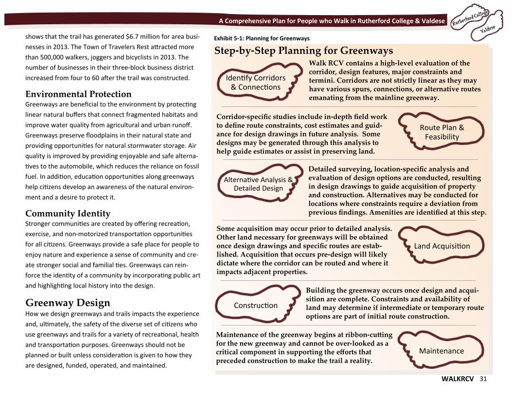
WALKRCV 31
A Comprehensive Plan for People who Walk in Rutherford College & Valdese
shows that the trail has generated $6.7 million for area busi-
nesses in 2013. The Town of Travelers Rest attracted more
than 500,000 walkers, joggers and bicyclists in 2013. The
number of businesses in their three-block business district
increased from four to 60 after the trail was constructed.
Environmental Protection Greenways are beneficial to the environment by protecting
linear natural buffers that connect fragmented habitats and
improve water quality from agricultural and urban runoff.
Greenways preserve floodplains in their natural state and
providing opportunities for natural stormwater storage. Air
quality is improved by providing enjoyable and safe alterna-
tives to the automobile, which reduces the reliance on fossil
fuel. In addition, education opportunities along greenways
help citizens develop an awareness of the natural environ-
ment and a desire to protect it.
Community Identity Stronger communities are created by offering recreation,
exercise, and non-motorized transportation opportunities
for all citizens. Greenways provide a safe place for people to
enjoy nature and experience a sense of community and cre-
ate stronger social and familial ties. Greenways can rein-
force the identity of a community by incorporating public art
and highlighting local history into the design.
Greenway Design How we design greenways and trails impacts the experience
and, ultimately, the safety of the diverse set of citizens who
use greenways and trails for a variety of recreational, health
and transportation purposes. Greenways should not be
planned or built unless consideration is given to how they
are designed, funded, operated, and maintained.
Step-by-Step Planning for Greenways
Exhibit 5-1: Planning for Greenways
Identify Corridors & Connections
Walk RCV contains a high-level evaluation of the corridor, design features, major constraints and termini. Corridors are not strictly linear as they may have various spurs, connections, or alternative routes emanating from the mainline greenway.
Route Plan & Feasibility
Alternative Analysis & Detailed Design
Corridor-specific studies include in-depth field work to define route constraints, cost estimates and guid-ance for design drawings in future analysis. Some designs may be generated through this analysis to help guide estimates or assist in preserving land.
Land Acquisition
Detailed surveying, location-specific analysis and evaluation of design options are conducted, resulting in design drawings to guide acquisition of property and construction. Alternatives may be conducted for locations where constraints require a deviation from previous findings. Amenities are identified at this step.
Construction
Some acquisition may occur prior to detailed analysis. Other land necessary for greenways will be obtained once design drawings and specific routes are estab-lished. Acquisition that occurs pre-design will likely dictate where the corridor can be routed and where it impacts adjacent properties.
Maintenance
Maintenance of the greenway begins at ribbon-cutting for the new greenway and cannot be over-looked as a critical component in supporting the efforts that preceded construction to make the trail a reality.
Building the greenway occurs once design and acqui-sition are complete. Constraints and availability of land may determine if intermediate or temporary route options are part of initial route construction.
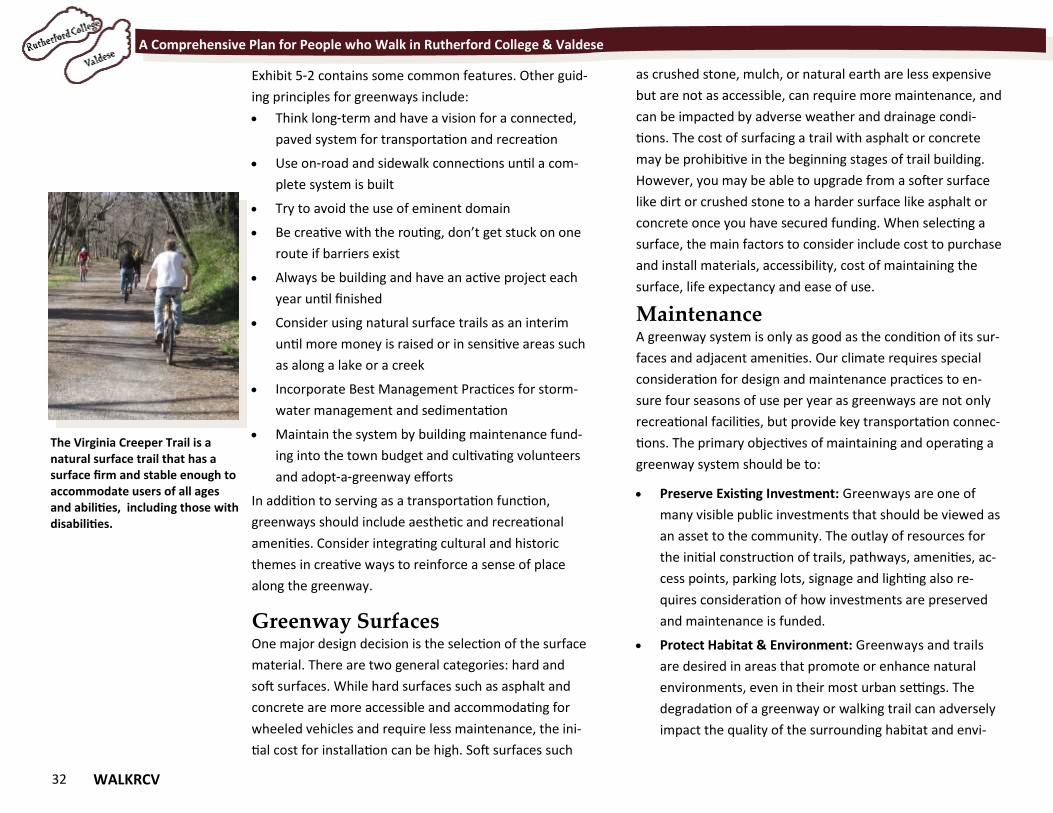
32 WALKRCV
A Comprehensive Plan for People who Walk in Rutherford College & Valdese
Exhibit 5-2 contains some common features. Other guid-
ing principles for greenways include:
Think long-term and have a vision for a connected,
paved system for transportation and recreation
Use on-road and sidewalk connections until a com-
plete system is built
Try to avoid the use of eminent domain
Be creative with the routing, don’t get stuck on one
route if barriers exist
Always be building and have an active project each
year until finished
Consider using natural surface trails as an interim
until more money is raised or in sensitive areas such
as along a lake or a creek
Incorporate Best Management Practices for storm-
water management and sedimentation
Maintain the system by building maintenance fund-
ing into the town budget and cultivating volunteers
and adopt-a-greenway efforts
In addition to serving as a transportation function,
greenways should include aesthetic and recreational
amenities. Consider integrating cultural and historic
themes in creative ways to reinforce a sense of place
along the greenway.
Greenway Surfaces One major design decision is the selection of the surface
material. There are two general categories: hard and
soft surfaces. While hard surfaces such as asphalt and
concrete are more accessible and accommodating for
wheeled vehicles and require less maintenance, the ini-
tial cost for installation can be high. Soft surfaces such
as crushed stone, mulch, or natural earth are less expensive
but are not as accessible, can require more maintenance, and
can be impacted by adverse weather and drainage condi-
tions. The cost of surfacing a trail with asphalt or concrete
may be prohibitive in the beginning stages of trail building.
However, you may be able to upgrade from a softer surface
like dirt or crushed stone to a harder surface like asphalt or
concrete once you have secured funding. When selecting a
surface, the main factors to consider include cost to purchase
and install materials, accessibility, cost of maintaining the
surface, life expectancy and ease of use.
Maintenance A greenway system is only as good as the condition of its sur-
faces and adjacent amenities. Our climate requires special
consideration for design and maintenance practices to en-
sure four seasons of use per year as greenways are not only
recreational facilities, but provide key transportation connec-
tions. The primary objectives of maintaining and operating a
greenway system should be to:
Preserve Existing Investment: Greenways are one of
many visible public investments that should be viewed as
an asset to the community. The outlay of resources for
the initial construction of trails, pathways, amenities, ac-
cess points, parking lots, signage and lighting also re-
quires consideration of how investments are preserved
and maintenance is funded.
Protect Habitat & Environment: Greenways and trails
are desired in areas that promote or enhance natural
environments, even in their most urban settings. The
degradation of a greenway or walking trail can adversely
impact the quality of the surrounding habitat and envi-
The Virginia Creeper Trail is a natural surface trail that has a surface firm and stable enough to accommodate users of all ages and abilities, including those with disabilities.
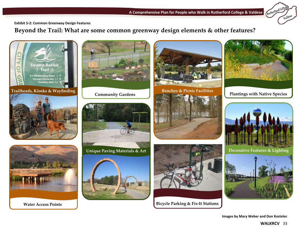
WALKRCV 33
A Comprehensive Plan for People who Walk in Rutherford College & Valdese
Exhibit 5-2: Common Greenway Design Features
Beyond the Trail: What are some common greenway design elements & other features?
Trailheads, Kiosks & Wayfinding
Unique Paving Materials & Art
Community Gardens
Water Access Points
Benches & Picnic Facilities
Bicycle Parking & Fix-It Stations
Decorative Features & Lighting
Plantings with Native Species
Images by Mary Weber and Don Kostelec
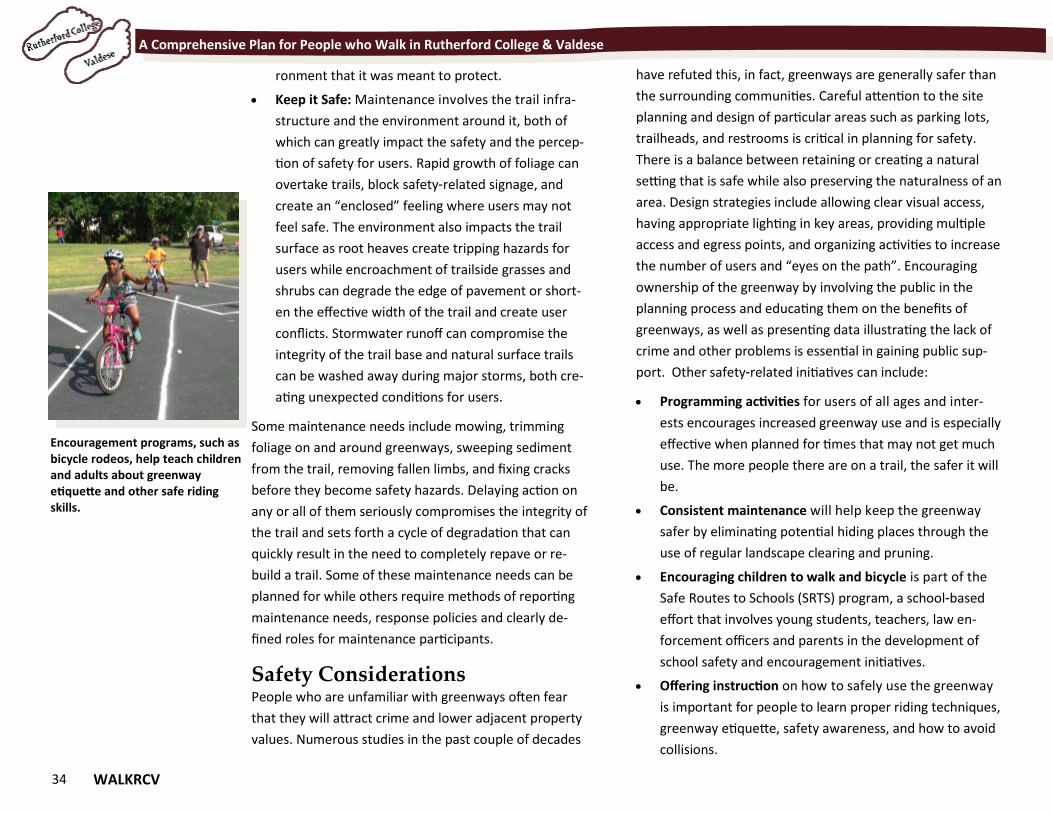
34 WALKRCV
A Comprehensive Plan for People who Walk in Rutherford College & Valdese
ronment that it was meant to protect.
Keep it Safe: Maintenance involves the trail infra-
structure and the environment around it, both of
which can greatly impact the safety and the percep-
tion of safety for users. Rapid growth of foliage can
overtake trails, block safety-related signage, and
create an “enclosed” feeling where users may not
feel safe. The environment also impacts the trail
surface as root heaves create tripping hazards for
users while encroachment of trailside grasses and
shrubs can degrade the edge of pavement or short-
en the effective width of the trail and create user
conflicts. Stormwater runoff can compromise the
integrity of the trail base and natural surface trails
can be washed away during major storms, both cre-
ating unexpected conditions for users.
Some maintenance needs include mowing, trimming
foliage on and around greenways, sweeping sediment
from the trail, removing fallen limbs, and fixing cracks
before they become safety hazards. Delaying action on
any or all of them seriously compromises the integrity of
the trail and sets forth a cycle of degradation that can
quickly result in the need to completely repave or re-
build a trail. Some of these maintenance needs can be
planned for while others require methods of reporting
maintenance needs, response policies and clearly de-
fined roles for maintenance participants.
Safety Considerations People who are unfamiliar with greenways often fear
that they will attract crime and lower adjacent property
values. Numerous studies in the past couple of decades
have refuted this, in fact, greenways are generally safer than
the surrounding communities. Careful attention to the site
planning and design of particular areas such as parking lots,
trailheads, and restrooms is critical in planning for safety.
There is a balance between retaining or creating a natural
setting that is safe while also preserving the naturalness of an
area. Design strategies include allowing clear visual access,
having appropriate lighting in key areas, providing multiple
access and egress points, and organizing activities to increase
the number of users and “eyes on the path”. Encouraging
ownership of the greenway by involving the public in the
planning process and educating them on the benefits of
greenways, as well as presenting data illustrating the lack of
crime and other problems is essential in gaining public sup-
port. Other safety-related initiatives can include:
Programming activities for users of all ages and inter-
ests encourages increased greenway use and is especially
effective when planned for times that may not get much
use. The more people there are on a trail, the safer it will
be.
Consistent maintenance will help keep the greenway
safer by eliminating potential hiding places through the
use of regular landscape clearing and pruning.
Encouraging children to walk and bicycle is part of the
Safe Routes to Schools (SRTS) program, a school-based
effort that involves young students, teachers, law en-
forcement officers and parents in the development of
school safety and encouragement initiatives.
Offering instruction on how to safely use the greenway
is important for people to learn proper riding techniques,
greenway etiquette, safety awareness, and how to avoid
collisions.
Encouragement programs, such as bicycle rodeos, help teach children and adults about greenway etiquette and other safe riding skills.
WALKRCV 35
Chapter 6 Get out and walk Chapter 6 Get out and walk
“Walking is the best possible exercise. Habituate yourself to walk very far.” - Thomas Jefferson
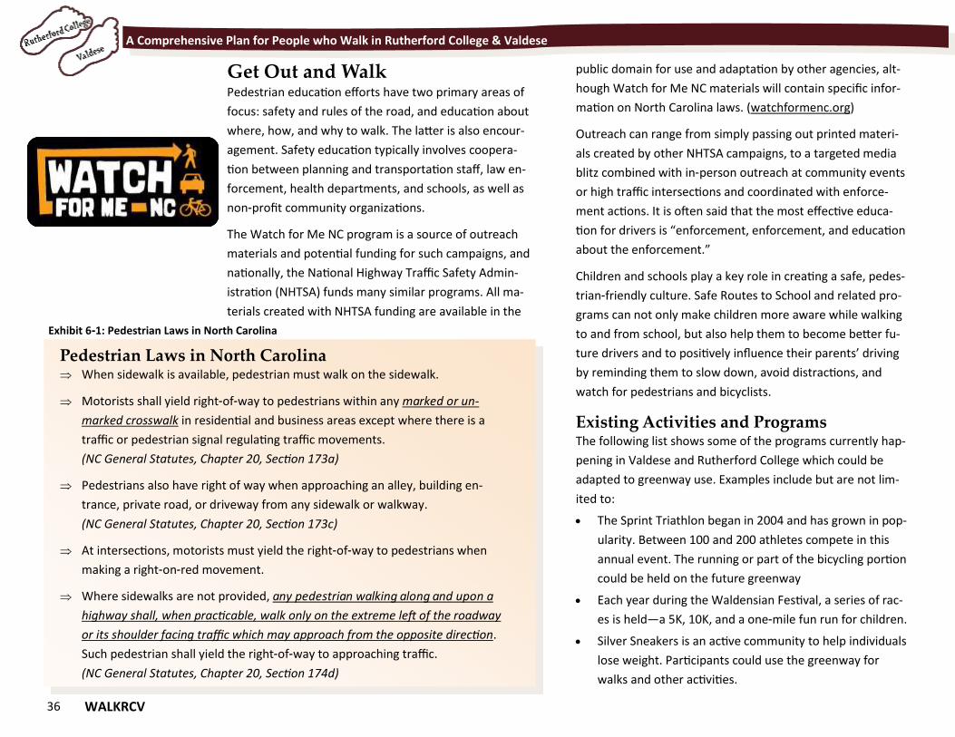
36 WALKRCV
A Comprehensive Plan for People who Walk in Rutherford College & Valdese
Get Out and Walk Pedestrian education efforts have two primary areas of
focus: safety and rules of the road, and education about
where, how, and why to walk. The latter is also encour-
agement. Safety education typically involves coopera-
tion between planning and transportation staff, law en-
forcement, health departments, and schools, as well as
non-profit community organizations.
The Watch for Me NC program is a source of outreach
materials and potential funding for such campaigns, and
nationally, the National Highway Traffic Safety Admin-
istration (NHTSA) funds many similar programs. All ma-
terials created with NHTSA funding are available in the
public domain for use and adaptation by other agencies, alt-
hough Watch for Me NC materials will contain specific infor-
mation on North Carolina laws. (watchformenc.org)
Outreach can range from simply passing out printed materi-
als created by other NHTSA campaigns, to a targeted media
blitz combined with in-person outreach at community events
or high traffic intersections and coordinated with enforce-
ment actions. It is often said that the most effective educa-
tion for drivers is “enforcement, enforcement, and education
about the enforcement.”
Children and schools play a key role in creating a safe, pedes-
trian-friendly culture. Safe Routes to School and related pro-
grams can not only make children more aware while walking
to and from school, but also help them to become better fu-
ture drivers and to positively influence their parents’ driving
by reminding them to slow down, avoid distractions, and
watch for pedestrians and bicyclists.
Existing Activities and Programs The following list shows some of the programs currently hap-
pening in Valdese and Rutherford College which could be
adapted to greenway use. Examples include but are not lim-
ited to:
The Sprint Triathlon began in 2004 and has grown in pop-
ularity. Between 100 and 200 athletes compete in this
annual event. The running or part of the bicycling portion
could be held on the future greenway
Each year during the Waldensian Festival, a series of rac-
es is held—a 5K, 10K, and a one-mile fun run for children.
Silver Sneakers is an active community to help individuals
lose weight. Participants could use the greenway for
walks and other activities.
Pedestrian Laws in North Carolina When sidewalk is available, pedestrian must walk on the sidewalk.
Motorists shall yield right-of-way to pedestrians within any marked or un-
marked crosswalk in residential and business areas except where there is a
traffic or pedestrian signal regulating traffic movements.
(NC General Statutes, Chapter 20, Section 173a)
Pedestrians also have right of way when approaching an alley, building en-
trance, private road, or driveway from any sidewalk or walkway.
(NC General Statutes, Chapter 20, Section 173c)
At intersections, motorists must yield the right-of-way to pedestrians when
making a right-on-red movement.
Where sidewalks are not provided, any pedestrian walking along and upon a
highway shall, when practicable, walk only on the extreme left of the roadway
or its shoulder facing traffic which may approach from the opposite direction.
Such pedestrian shall yield the right-of-way to approaching traffic.
(NC General Statutes, Chapter 20, Section 174d)
Exhibit 6-1: Pedestrian Laws in North Carolina
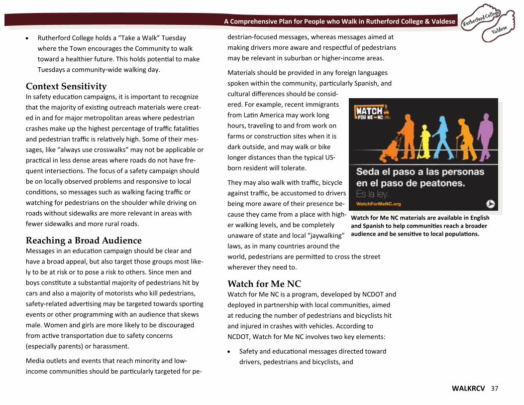
WALKRCV 37
A Comprehensive Plan for People who Walk in Rutherford College & Valdese
Rutherford College holds a “Take a Walk” Tuesday
where the Town encourages the Community to walk
toward a healthier future. This holds potential to make
Tuesdays a community-wide walking day.
Context Sensitivity In safety education campaigns, it is important to recognize
that the majority of existing outreach materials were creat-
ed in and for major metropolitan areas where pedestrian
crashes make up the highest percentage of traffic fatalities
and pedestrian traffic is relatively high. Some of their mes-
sages, like “always use crosswalks” may not be applicable or
practical in less dense areas where roads do not have fre-
quent intersections. The focus of a safety campaign should
be on locally observed problems and responsive to local
conditions, so messages such as walking facing traffic or
watching for pedestrians on the shoulder while driving on
roads without sidewalks are more relevant in areas with
fewer sidewalks and more rural roads.
Reaching a Broad Audience Messages in an education campaign should be clear and
have a broad appeal, but also target those groups most like-
ly to be at risk or to pose a risk to others. Since men and
boys constitute a substantial majority of pedestrians hit by
cars and also a majority of motorists who kill pedestrians,
safety-related advertising may be targeted towards sporting
events or other programming with an audience that skews
male. Women and girls are more likely to be discouraged
from active transportation due to safety concerns
(especially parents) or harassment.
Media outlets and events that reach minority and low-
income communities should be particularly targeted for pe-
destrian-focused messages, whereas messages aimed at
making drivers more aware and respectful of pedestrians
may be relevant in suburban or higher-income areas.
Materials should be provided in any foreign languages
spoken within the community, particularly Spanish, and
cultural differences should be consid-
ered. For example, recent immigrants
from Latin America may work long
hours, traveling to and from work on
farms or construction sites when it is
dark outside, and may walk or bike
longer distances than the typical US-
born resident will tolerate.
They may also walk with traffic, bicycle
against traffic, be accustomed to drivers
being more aware of their presence be-
cause they came from a place with high-
er walking levels, and be completely
unaware of state and local “jaywalking”
laws, as in many countries around the
world, pedestrians are permitted to cross the street
wherever they need to.
Watch for Me NC Watch for Me NC is a program, developed by NCDOT and
deployed in partnership with local communities, aimed
at reducing the number of pedestrians and bicyclists hit
and injured in crashes with vehicles. According to
NCDOT, Watch for Me NC involves two key elements:
Safety and educational messages directed toward
drivers, pedestrians and bicyclists, and
Watch for Me NC materials are available in English and Spanish to help communities reach a broader audience and be sensitive to local populations.
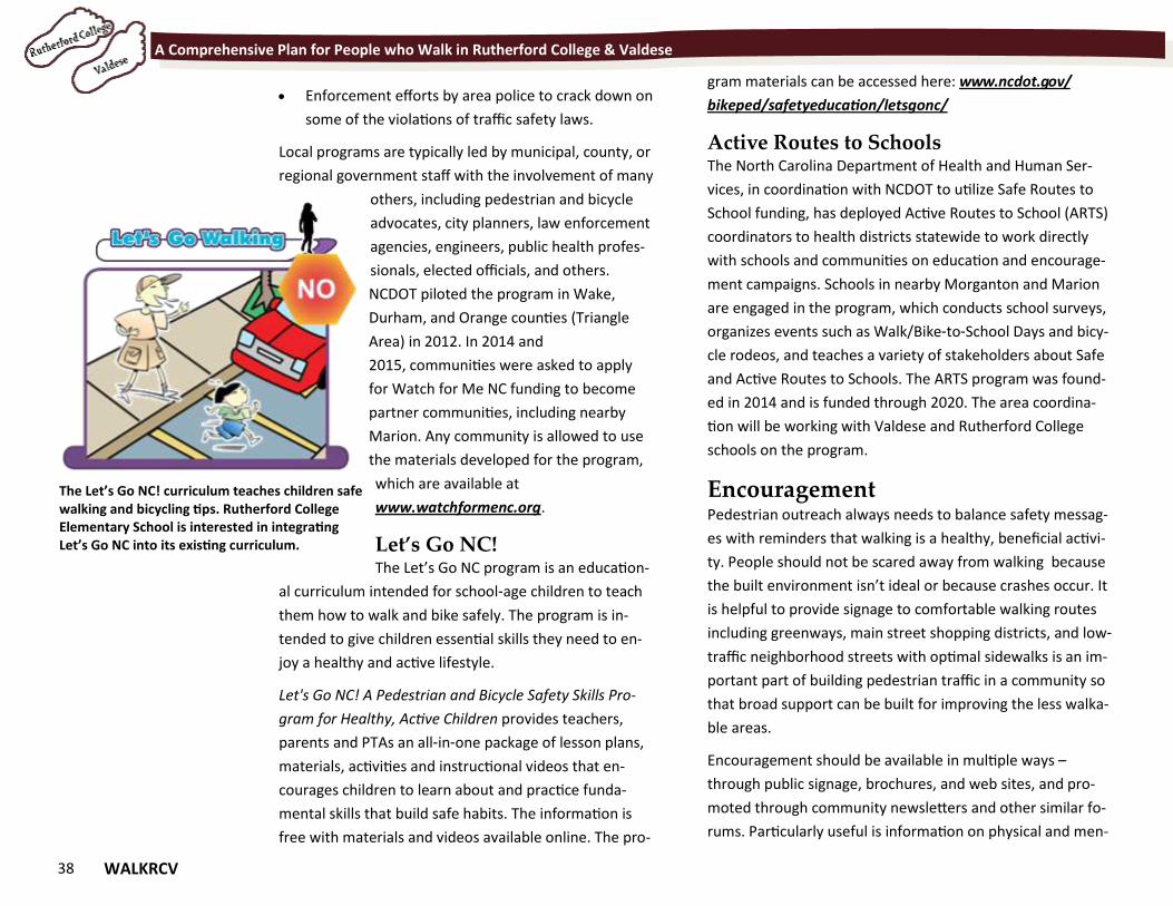
38 WALKRCV
A Comprehensive Plan for People who Walk in Rutherford College & Valdese
Enforcement efforts by area police to crack down on
some of the violations of traffic safety laws.
Local programs are typically led by municipal, county, or
regional government staff with the involvement of many
others, including pedestrian and bicycle
advocates, city planners, law enforcement
agencies, engineers, public health profes-
sionals, elected officials, and others.
NCDOT piloted the program in Wake,
Durham, and Orange counties (Triangle
Area) in 2012. In 2014 and
2015, communities were asked to apply
for Watch for Me NC funding to become
partner communities, including nearby
Marion. Any community is allowed to use
the materials developed for the program,
which are available at
www.watchformenc.org.
Let’s Go NC! The Let’s Go NC program is an education-
al curriculum intended for school-age children to teach
them how to walk and bike safely. The program is in-
tended to give children essential skills they need to en-
joy a healthy and active lifestyle.
Let's Go NC! A Pedestrian and Bicycle Safety Skills Pro-
gram for Healthy, Active Children provides teachers,
parents and PTAs an all-in-one package of lesson plans,
materials, activities and instructional videos that en-
courages children to learn about and practice funda-
mental skills that build safe habits. The information is
free with materials and videos available online. The pro-
gram materials can be accessed here: www.ncdot.gov/
bikeped/safetyeducation/letsgonc/
Active Routes to Schools The North Carolina Department of Health and Human Ser-
vices, in coordination with NCDOT to utilize Safe Routes to
School funding, has deployed Active Routes to School (ARTS)
coordinators to health districts statewide to work directly
with schools and communities on education and encourage-
ment campaigns. Schools in nearby Morganton and Marion
are engaged in the program, which conducts school surveys,
organizes events such as Walk/Bike-to-School Days and bicy-
cle rodeos, and teaches a variety of stakeholders about Safe
and Active Routes to Schools. The ARTS program was found-
ed in 2014 and is funded through 2020. The area coordina-
tion will be working with Valdese and Rutherford College
schools on the program.
Encouragement Pedestrian outreach always needs to balance safety messag-
es with reminders that walking is a healthy, beneficial activi-
ty. People should not be scared away from walking because
the built environment isn’t ideal or because crashes occur. It
is helpful to provide signage to comfortable walking routes
including greenways, main street shopping districts, and low-
traffic neighborhood streets with optimal sidewalks is an im-
portant part of building pedestrian traffic in a community so
that broad support can be built for improving the less walka-
ble areas.
Encouragement should be available in multiple ways –
through public signage, brochures, and web sites, and pro-
moted through community newsletters and other similar fo-
rums. Particularly useful is information on physical and men-
The Let’s Go NC! curriculum teaches children safe walking and bicycling tips. Rutherford College Elementary School is interested in integrating Let’s Go NC into its existing curriculum.
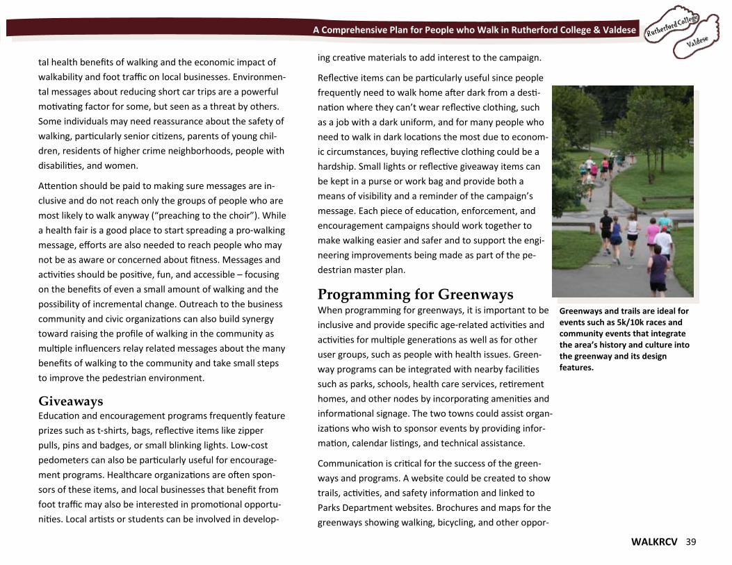
WALKRCV 39
A Comprehensive Plan for People who Walk in Rutherford College & Valdese
tal health benefits of walking and the economic impact of
walkability and foot traffic on local businesses. Environmen-
tal messages about reducing short car trips are a powerful
motivating factor for some, but seen as a threat by others.
Some individuals may need reassurance about the safety of
walking, particularly senior citizens, parents of young chil-
dren, residents of higher crime neighborhoods, people with
disabilities, and women.
Attention should be paid to making sure messages are in-
clusive and do not reach only the groups of people who are
most likely to walk anyway (“preaching to the choir”). While
a health fair is a good place to start spreading a pro-walking
message, efforts are also needed to reach people who may
not be as aware or concerned about fitness. Messages and
activities should be positive, fun, and accessible – focusing
on the benefits of even a small amount of walking and the
possibility of incremental change. Outreach to the business
community and civic organizations can also build synergy
toward raising the profile of walking in the community as
multiple influencers relay related messages about the many
benefits of walking to the community and take small steps
to improve the pedestrian environment.
Giveaways Education and encouragement programs frequently feature
prizes such as t-shirts, bags, reflective items like zipper
pulls, pins and badges, or small blinking lights. Low-cost
pedometers can also be particularly useful for encourage-
ment programs. Healthcare organizations are often spon-
sors of these items, and local businesses that benefit from
foot traffic may also be interested in promotional opportu-
nities. Local artists or students can be involved in develop-
ing creative materials to add interest to the campaign.
Reflective items can be particularly useful since people
frequently need to walk home after dark from a desti-
nation where they can’t wear reflective clothing, such
as a job with a dark uniform, and for many people who
need to walk in dark locations the most due to econom-
ic circumstances, buying reflective clothing could be a
hardship. Small lights or reflective giveaway items can
be kept in a purse or work bag and provide both a
means of visibility and a reminder of the campaign’s
message. Each piece of education, enforcement, and
encouragement campaigns should work together to
make walking easier and safer and to support the engi-
neering improvements being made as part of the pe-
destrian master plan.
Programming for Greenways When programming for greenways, it is important to be
inclusive and provide specific age-related activities and
activities for multiple generations as well as for other
user groups, such as people with health issues. Green-
way programs can be integrated with nearby facilities
such as parks, schools, health care services, retirement
homes, and other nodes by incorporating amenities and
informational signage. The two towns could assist organ-
izations who wish to sponsor events by providing infor-
mation, calendar listings, and technical assistance.
Communication is critical for the success of the green-
ways and programs. A website could be created to show
trails, activities, and safety information and linked to
Parks Department websites. Brochures and maps for the
greenways showing walking, bicycling, and other oppor-
Greenways and trails are ideal for events such as 5k/10k races and community events that integrate the area’s history and culture into the greenway and its design features.
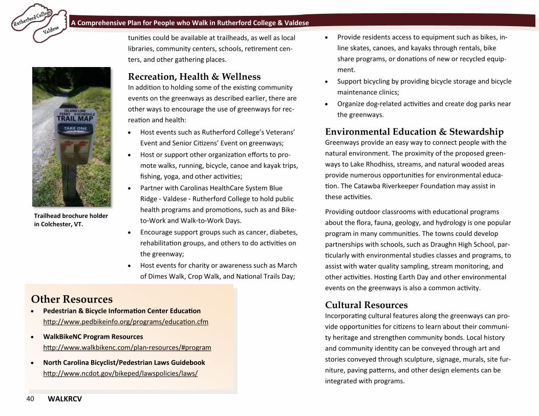
40 WALKRCV
A Comprehensive Plan for People who Walk in Rutherford College & Valdese
tunities could be available at trailheads, as well as local
libraries, community centers, schools, retirement cen-
ters, and other gathering places.
Recreation, Health & Wellness In addition to holding some of the existing community
events on the greenways as described earlier, there are
other ways to encourage the use of greenways for rec-
reation and health:
Host events such as Rutherford College’s Veterans’
Event and Senior Citizens’ Event on greenways;
Host or support other organization efforts to pro-
mote walks, running, bicycle, canoe and kayak trips,
fishing, yoga, and other activities;
Partner with Carolinas HealthCare System Blue
Ridge - Valdese - Rutherford College to hold public
health programs and promotions, such as and Bike-
to-Work and Walk-to-Work Days.
Encourage support groups such as cancer, diabetes,
rehabilitation groups, and others to do activities on
the greenway;
Host events for charity or awareness such as March
of Dimes Walk, Crop Walk, and National Trails Day;
Other Resources Pedestrian & Bicycle Information Center Education
http://www.pedbikeinfo.org/programs/education.cfm
WalkBikeNC Program Resources
http://www.walkbikenc.com/plan-resources/#program
North Carolina Bicyclist/Pedestrian Laws Guidebook
http://www.ncdot.gov/bikeped/lawspolicies/laws/
Provide residents access to equipment such as bikes, in-
line skates, canoes, and kayaks through rentals, bike
share programs, or donations of new or recycled equip-
ment.
Support bicycling by providing bicycle storage and bicycle
maintenance clinics;
Organize dog-related activities and create dog parks near
the greenways.
Environmental Education & Stewardship Greenways provide an easy way to connect people with the
natural environment. The proximity of the proposed green-
ways to Lake Rhodhiss, streams, and natural wooded areas
provide numerous opportunities for environmental educa-
tion. The Catawba Riverkeeper Foundation may assist in
these activities.
Providing outdoor classrooms with educational programs
about the flora, fauna, geology, and hydrology is one popular
program in many communities. The towns could develop
partnerships with schools, such as Draughn High School, par-
ticularly with environmental studies classes and programs, to
assist with water quality sampling, stream monitoring, and
other activities. Hosting Earth Day and other environmental
events on the greenways is also a common activity.
Cultural Resources Incorporating cultural features along the greenways can pro-
vide opportunities for citizens to learn about their communi-
ty heritage and strengthen community bonds. Local history
and community identity can be conveyed through art and
stories conveyed through sculpture, signage, murals, site fur-
niture, paving patterns, and other design elements can be
integrated with programs.
Trailhead brochure holder in Colchester, VT.
WALKRCV 41
Chapter 7 Building a System for People Who Walk
Chapter 7 Building a System for People Who Walk
“Yes, we'll walk with a walk that is measured and slow, and we'll go where the chalk-white arrows go, for the children, they mark, and the children, they know, the place where the sidewalk ends.” - Shel Silverstein
42 WALKRCV
A Comprehensive Plan for People who Walk in Rutherford College & Valdese
Building a System for
People Who Walk Developing a list of projects to improve walkability in
Rutherford College and Valdese is not as simple as iden-
tifying where sidewalks exist and where they are miss-
ing. Rather, it is necessary to identify destinations or
land uses that are most likely to generate pedestrian
trips if linked through a network of quality pedestrian
facilities.
Overall, Valdese and Rutherford College have a network
for walking where the main roads between major desti-
nations have a sidewalk on at least one side. Each com-
munity’s downtown area has a sidewalk network and
there are very few places where people who walk are
exposed to poor walking conditions along high speed,
high volume traffic routes. Chapter 3 summarizes the
conditions along major routes. The project recommen-
dations in this chapter are intended to create a network
inclusive of those routes, promote safer crossing treat-
ments for major routes, and add a new set of greenways
to the mix.
Some projects will require joint funding and grant pur-
suits from the two towns while others will be pursued
exclusively by Valdese or Rutherford College.
Overall Recommendations Identifying projects for WalkRCV consisted of:
Reviewing project recommendations from any past
planning efforts, most notably the Land Use Plans
for the two towns and the Valdese Sidewalk Study;
Gathering feedback at the Steering Committee
meetings and public involvement efforts;
Conducting field evaluation of walking conditions along
streets and evaluating likely greenway routes where
property access was available; and
Identifying popular destinations and walking routes.
From this input, projects recommendations are developed at
what is referred to as “planning level,” meaning that they
were examined for their relative value and evaluated based
on field observations (Exhibit 7-1). Detailed right-of-way or
design processes were not conducted as part of this Plan,
rather those steps will follow as the Towns, NCDOT, and oth-
er partners work toward implementation.
The cost estimates contained in this Plan are based on this
planning level evaluation and prevailing costs per mile of sim-
ilar facilities at the time of Plan development. Costs will
change, as they always do. It is best for Rutherford College
and Valdese to work through the COG and NCDOT Division 13
at the time a project grant is being pursued so these esti-
mates can be updated.
Project Development. To become reality, projects may go
through up to four phases depending on level of complexity.
1. Feasibility studies may occur on projects like greenways
or streetscape plans to gather more information. This
could include a field review by Town staff or with the
help of consultants, and review of available right-of-way;
2. Most projects begin with Design, which is the surveying,
measuring and scoping of the project to produce a set of
drawings to define the exact parameters of the projects
and the manner in which it can be constructed;
3. Acquisition of land may then occur if the project design
process indicates additional land is needed; in some cas-
es there may be existing right-of-way to accommodate
the project; and
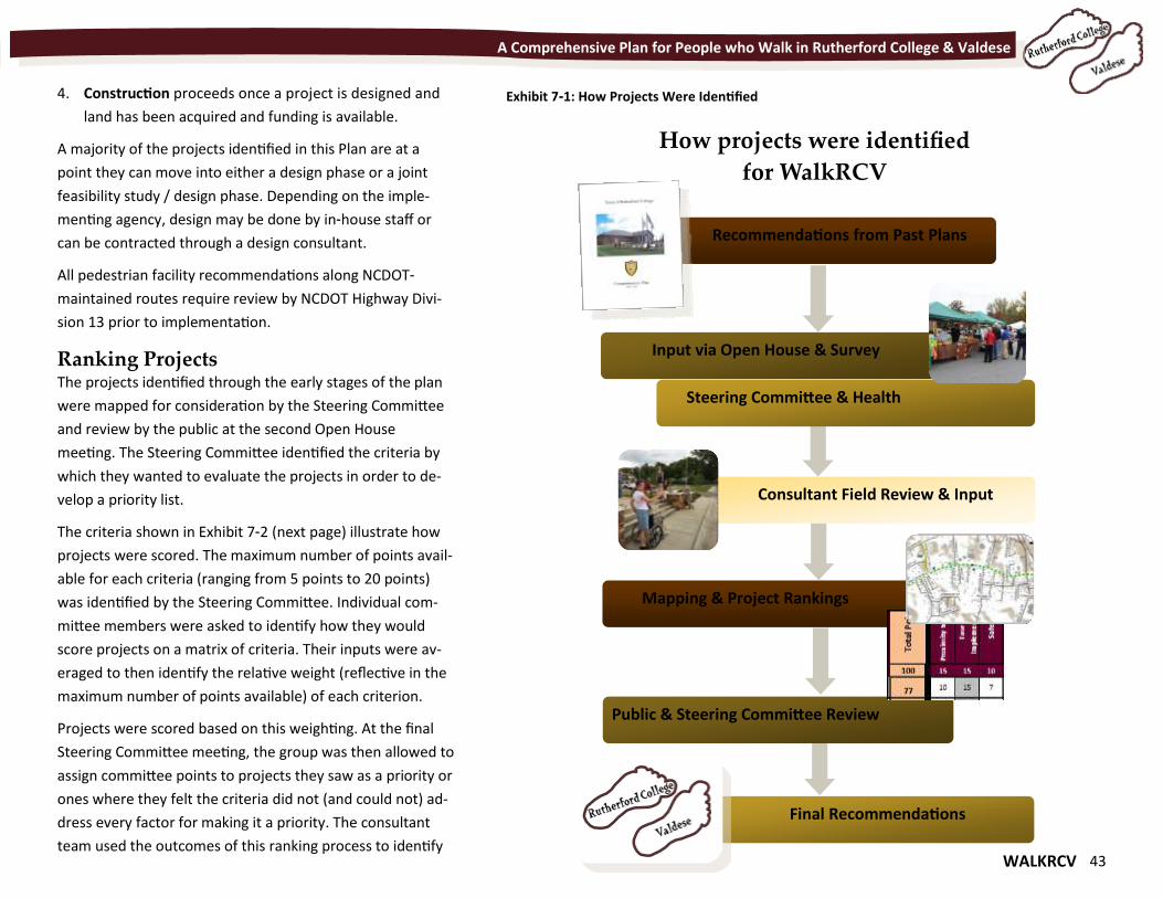
WALKRCV 43
A Comprehensive Plan for People who Walk in Rutherford College & Valdese
4. Construction proceeds once a project is designed and
land has been acquired and funding is available.
A majority of the projects identified in this Plan are at a
point they can move into either a design phase or a joint
feasibility study / design phase. Depending on the imple-
menting agency, design may be done by in-house staff or
can be contracted through a design consultant.
All pedestrian facility recommendations along NCDOT-
maintained routes require review by NCDOT Highway Divi-
sion 13 prior to implementation.
Ranking Projects The projects identified through the early stages of the plan
were mapped for consideration by the Steering Committee
and review by the public at the second Open House
meeting. The Steering Committee identified the criteria by
which they wanted to evaluate the projects in order to de-
velop a priority list.
The criteria shown in Exhibit 7-2 (next page) illustrate how
projects were scored. The maximum number of points avail-
able for each criteria (ranging from 5 points to 20 points)
was identified by the Steering Committee. Individual com-
mittee members were asked to identify how they would
score projects on a matrix of criteria. Their inputs were av-
eraged to then identify the relative weight (reflective in the
maximum number of points available) of each criterion.
Projects were scored based on this weighting. At the final
Steering Committee meeting, the group was then allowed to
assign committee points to projects they saw as a priority or
ones where they felt the criteria did not (and could not) ad-
dress every factor for making it a priority. The consultant
team used the outcomes of this ranking process to identify
Mapping & Project Rankings
Recommendations from Past Plans
Input via Open House & Survey
Steering Committee & Health
Consultant Field Review & Input
Public & Steering Committee Review
Final Recommendations
Exhibit 7-1: How Projects Were Identified
How projects were identified
for WalkRCV
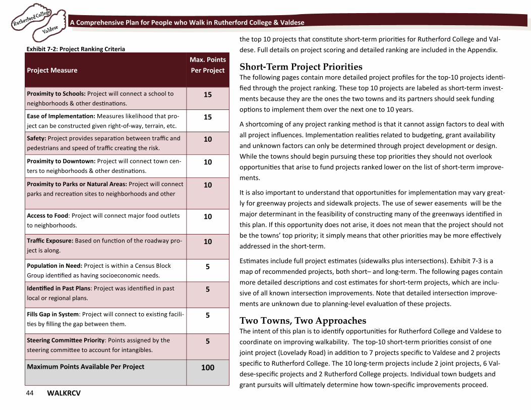
44 WALKRCV
A Comprehensive Plan for People who Walk in Rutherford College & Valdese
the top 10 projects that constitute short-term priorities for Rutherford College and Val-
dese. Full details on project scoring and detailed ranking are included in the Appendix.
Short-Term Project Priorities The following pages contain more detailed project profiles for the top-10 projects identi-
fied through the project ranking. These top 10 projects are labeled as short-term invest-
ments because they are the ones the two towns and its partners should seek funding
options to implement them over the next one to 10 years.
A shortcoming of any project ranking method is that it cannot assign factors to deal with
all project influences. Implementation realities related to budgeting, grant availability
and unknown factors can only be determined through project development or design.
While the towns should begin pursuing these top priorities they should not overlook
opportunities that arise to fund projects ranked lower on the list of short-term improve-
ments.
It is also important to understand that opportunities for implementation may vary great-
ly for greenway projects and sidewalk projects. The use of sewer easements will be the
major determinant in the feasibility of constructing many of the greenways identified in
this plan. If this opportunity does not arise, it does not mean that the project should not
be the towns’ top priority; it simply means that other priorities may be more effectively
addressed in the short-term.
Estimates include full project estimates (sidewalks plus intersections). Exhibit 7-3 is a
map of recommended projects, both short– and long-term. The following pages contain
more detailed descriptions and cost estimates for short-term projects, which are inclu-
sive of all known intersection improvements. Note that detailed intersection improve-
ments are unknown due to planning-level evaluation of these projects.
Two Towns, Two Approaches The intent of this plan is to identify opportunities for Rutherford College and Valdese to
coordinate on improving walkability. The top-10 short-term priorities consist of one
joint project (Lovelady Road) in addition to 7 projects specific to Valdese and 2 projects
specific to Rutherford College. The 10 long-term projects include 2 joint projects, 6 Val-
dese-specific projects and 2 Rutherford College projects. Individual town budgets and
grant pursuits will ultimately determine how town-specific improvements proceed.
Project Measure
Max. Points
Per Project
Proximity to Schools: Project will connect a school to
neighborhoods & other destinations.
15
Ease of Implementation: Measures likelihood that pro-
ject can be constructed given right-of-way, terrain, etc.
15
Safety: Project provides separation between traffic and
pedestrians and speed of traffic creating the risk.
10
Proximity to Downtown: Project will connect town cen-
ters to neighborhoods & other destinations.
10
Proximity to Parks or Natural Areas: Project will connect
parks and recreation sites to neighborhoods and other
10
Access to Food: Project will connect major food outlets
to neighborhoods. 10
Traffic Exposure: Based on function of the roadway pro-
ject is along. 10
Population in Need: Project is within a Census Block
Group identified as having socioeconomic needs. 5
Identified in Past Plans: Project was identified in past
local or regional plans. 5
Fills Gap in System: Project will connect to existing facili-
ties by filling the gap between them. 5
Steering Committee Priority: Points assigned by the
steering committee to account for intangibles. 5
Maximum Points Available Per Project 100
Exhibit 7-2: Project Ranking Criteria
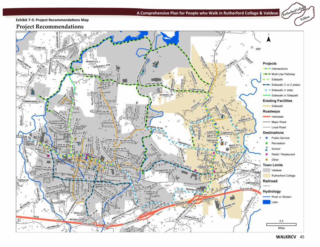
WALKRCV 45
A Comprehensive Plan for People who Walk in Rutherford College & Valdese
Exhibit 7-3: Project Recommendations Map
Project Recommendations
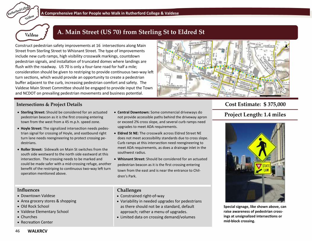
46 WALKRCV
A Comprehensive Plan for People who Walk in Rutherford College & Valdese
Construct pedestrian safety improvements at 16 intersections along Main Street from Sterling Street to Whisnant Street. The type of improvements include new curb ramps, high visibility crosswalk markings, countdown pedestrian signals, and installation of truncated domes where landings are flush with the roadway. US 70 is only a four-lane road for half a mile; consideration should be given to restriping to provide continuous two-way left turn sections, which would provide an opportunity to create a pedestrian buffer adjacent to the curb, increasing pedestrian comfort and safety. The Valdese Main Street Committee should be engaged to provide input the Town and NCDOT on prevailing pedestrian movements and business potential.
A. Main Street (US 70) from Sterling St to Eldred St
Intersections & Project Details
Sterling Street: Should be considered for an actuated pedestrian beacon as it is the first crossing entering town from the west from a 45 m.p.h. speed zone.
Hoyle Street: The signalized intersection needs pedes-trian signal for crossing of Hoyle, and eastbound right turn lane needs reengineering to protect crossing pe-destrians.
Roller Street: Sidewalk on Main St switches from the south side westward to the north side eastward at this intersection. The crossing needs to be marked and could be made safer with a mid-crossing refuge, another benefit of the restriping to continuous two-way left turn operation mentioned above.
Central Downtown: Some commercial driveways do not provide accessible paths behind the driveway apron or exceed 2% cross slope, and several curb ramps need upgrades to meet ADA requirements.
Eldred St NE: The crosswalk across Eldred Street NE does not meet accessibility standards due to cross slope. Curb ramps at this intersection need reengineering to meet ADA requirements, as does a drainage inlet in the southwest radius.
Whisnant Street: Should be considered for an actuated
pedestrian beacon as it is the first crossing entering
town from the east and is near the entrance to Chil-
dren’s Park.
Influences Challenges
Cost Estimate: $ 375,000
Project Length: 1.4 miles
Downtown Valdese Area grocery stores & shopping Old Rock School Valdese Elementary School Churches Recreation Center
Constrained right-of-way Variability in needed upgrades for pedestrians
as there should not be a standard, default approach; rather a menu of upgrades.
Limited data on crossing demand/volumes
Special signage, like shown above, can raise awareness of pedestrian cross-ings at unsignalized intersections or mid-block crossing.
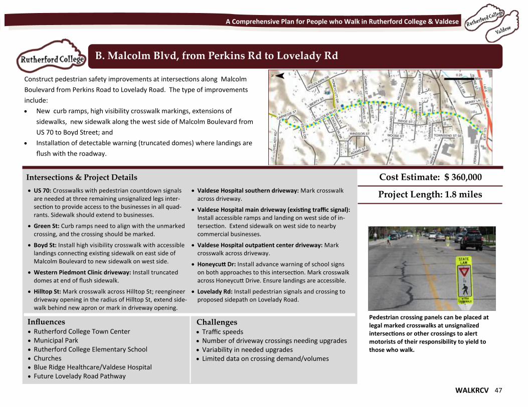
WALKRCV 47
A Comprehensive Plan for People who Walk in Rutherford College & Valdese
Construct pedestrian safety improvements at intersections along Malcolm
Boulevard from Perkins Road to Lovelady Road. The type of improvements
include:
New curb ramps, high visibility crosswalk markings, extensions of
sidewalks, new sidewalk along the west side of Malcolm Boulevard from
US 70 to Boyd Street; and
Installation of detectable warning (truncated domes) where landings are
flush with the roadway.
B. Malcolm Blvd, from Perkins Rd to Lovelady Rd
Intersections & Project Details
US 70: Crosswalks with pedestrian countdown signals are needed at three remaining unsignalized legs inter-section to provide access to the businesses in all quad-rants. Sidewalk should extend to businesses.
Green St: Curb ramps need to align with the unmarked crossing, and the crossing should be marked.
Boyd St: Install high visibility crosswalk with accessible landings connecting existing sidewalk on east side of Malcolm Boulevard to new sidewalk on west side.
Western Piedmont Clinic driveway: Install truncated domes at end of flush sidewalk.
Hilltop St: Mark crosswalk across Hilltop St; reengineer driveway opening in the radius of Hilltop St, extend side-walk behind new apron or mark in driveway opening.
Valdese Hospital southern driveway: Mark crosswalk across driveway.
Valdese Hospital main driveway (existing traffic signal): Install accessible ramps and landing on west side of in-tersection. Extend sidewalk on west side to nearby commercial businesses.
Valdese Hospital outpatient center driveway: Mark crosswalk across driveway.
Honeycutt Dr: Install advance warning of school signs on both approaches to this intersection. Mark crosswalk across Honeycutt Drive. Ensure landings are accessible.
Lovelady Rd: Install pedestrian signals and crossing to proposed sidepath on Lovelady Road.
Influences Challenges
Cost Estimate: $ 360,000
Project Length: 1.8 miles
Rutherford College Town Center Municipal Park Rutherford College Elementary School Churches Blue Ridge Healthcare/Valdese Hospital Future Lovelady Road Pathway
Traffic speeds Number of driveway crossings needing upgrades Variability in needed upgrades Limited data on crossing demand/volumes
Pedestrian crossing panels can be placed at legal marked crosswalks at unsignalized intersections or other crossings to alert motorists of their responsibility to yield to those who walk.
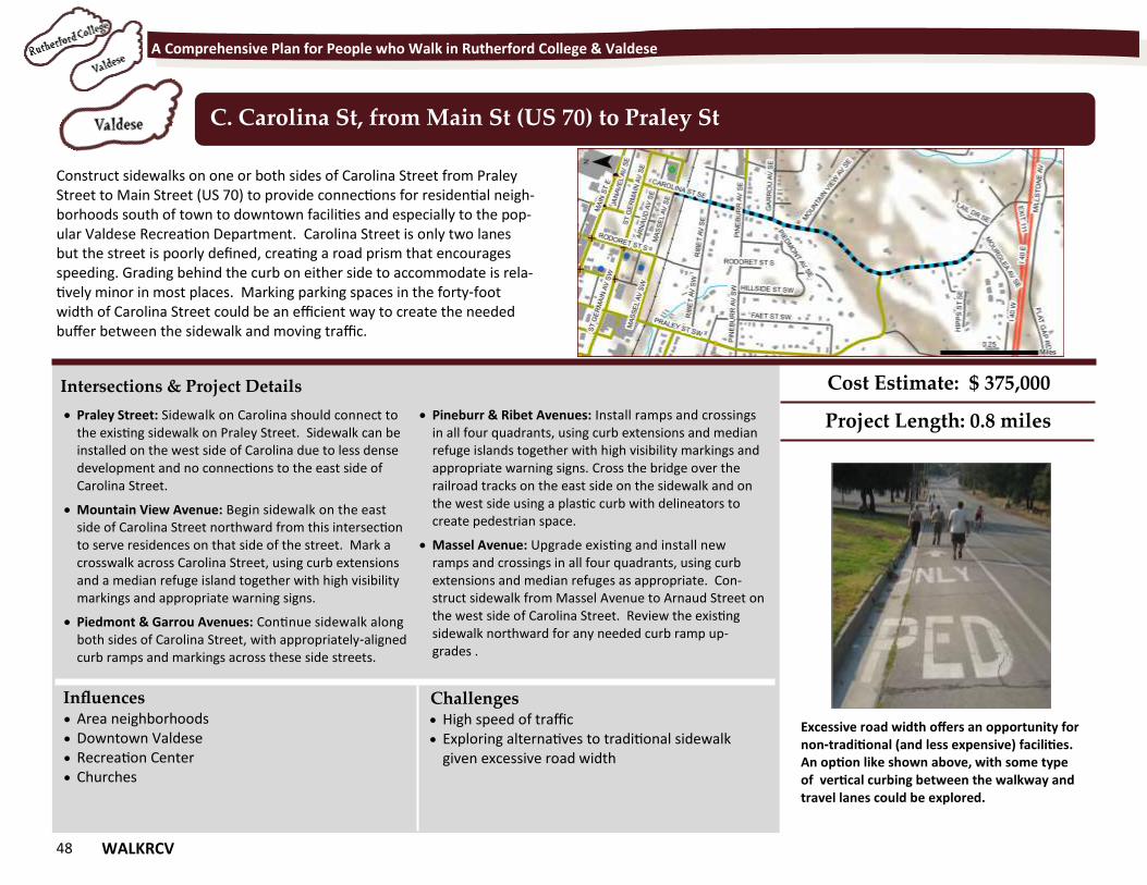
48 WALKRCV
A Comprehensive Plan for People who Walk in Rutherford College & Valdese
Construct sidewalks on one or both sides of Carolina Street from Praley Street to Main Street (US 70) to provide connections for residential neigh-borhoods south of town to downtown facilities and especially to the pop-ular Valdese Recreation Department. Carolina Street is only two lanes but the street is poorly defined, creating a road prism that encourages speeding. Grading behind the curb on either side to accommodate is rela-tively minor in most places. Marking parking spaces in the forty-foot width of Carolina Street could be an efficient way to create the needed buffer between the sidewalk and moving traffic.
C. Carolina St, from Main St (US 70) to Praley St
Intersections & Project Details
Praley Street: Sidewalk on Carolina should connect to the existing sidewalk on Praley Street. Sidewalk can be installed on the west side of Carolina due to less dense development and no connections to the east side of Carolina Street.
Mountain View Avenue: Begin sidewalk on the east side of Carolina Street northward from this intersection to serve residences on that side of the street. Mark a crosswalk across Carolina Street, using curb extensions and a median refuge island together with high visibility markings and appropriate warning signs.
Piedmont & Garrou Avenues: Continue sidewalk along both sides of Carolina Street, with appropriately-aligned curb ramps and markings across these side streets.
Pineburr & Ribet Avenues: Install ramps and crossings in all four quadrants, using curb extensions and median refuge islands together with high visibility markings and appropriate warning signs. Cross the bridge over the railroad tracks on the east side on the sidewalk and on the west side using a plastic curb with delineators to create pedestrian space.
Massel Avenue: Upgrade existing and install new ramps and crossings in all four quadrants, using curb extensions and median refuges as appropriate. Con-struct sidewalk from Massel Avenue to Arnaud Street on the west side of Carolina Street. Review the existing sidewalk northward for any needed curb ramp up-grades .
Influences Challenges
Cost Estimate: $ 375,000
Project Length: 0.8 miles
Area neighborhoods Downtown Valdese Recreation Center Churches
High speed of traffic Exploring alternatives to traditional sidewalk
given excessive road width
Excessive road width offers an opportunity for non-traditional (and less expensive) facilities. An option like shown above, with some type of vertical curbing between the walkway and travel lanes could be explored.
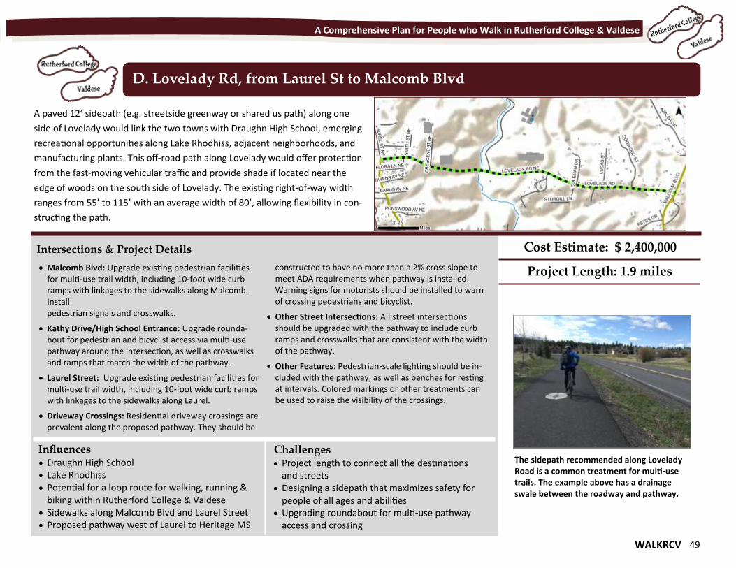
WALKRCV 49
A Comprehensive Plan for People who Walk in Rutherford College & Valdese
A paved 12’ sidepath (e.g. streetside greenway or shared us path) along one
side of Lovelady would link the two towns with Draughn High School, emerging
recreational opportunities along Lake Rhodhiss, adjacent neighborhoods, and
manufacturing plants. This off-road path along Lovelady would offer protection
from the fast-moving vehicular traffic and provide shade if located near the
edge of woods on the south side of Lovelady. The existing right-of-way width
ranges from 55’ to 115’ with an average width of 80’, allowing flexibility in con-
structing the path.
D. Lovelady Rd, from Laurel St to Malcomb Blvd
Intersections & Project Details
Malcomb Blvd: Upgrade existing pedestrian facilities for multi-use trail width, including 10-foot wide curb ramps with linkages to the sidewalks along Malcomb. Install pedestrian signals and crosswalks.
Kathy Drive/High School Entrance: Upgrade rounda-bout for pedestrian and bicyclist access via multi-use pathway around the intersection, as well as crosswalks and ramps that match the width of the pathway.
Laurel Street: Upgrade existing pedestrian facilities for multi-use trail width, including 10-foot wide curb ramps with linkages to the sidewalks along Laurel.
Driveway Crossings: Residential driveway crossings are prevalent along the proposed pathway. They should be
constructed to have no more than a 2% cross slope to meet ADA requirements when pathway is installed. Warning signs for motorists should be installed to warn of crossing pedestrians and bicyclist.
Other Street Intersections: All street intersections should be upgraded with the pathway to include curb ramps and crosswalks that are consistent with the width of the pathway.
Other Features: Pedestrian-scale lighting should be in-cluded with the pathway, as well as benches for resting at intervals. Colored markings or other treatments can be used to raise the visibility of the crossings.
Influences Challenges
Cost Estimate: $ 2,400,000
Project Length: 1.9 miles
Draughn High School Lake Rhodhiss Potential for a loop route for walking, running &
biking within Rutherford College & Valdese Sidewalks along Malcomb Blvd and Laurel Street Proposed pathway west of Laurel to Heritage MS
Project length to connect all the destinations and streets
Designing a sidepath that maximizes safety for people of all ages and abilities
Upgrading roundabout for multi-use pathway access and crossing
The sidepath recommended along Lovelady Road is a common treatment for multi-use trails. The example above has a drainage swale between the roadway and pathway.
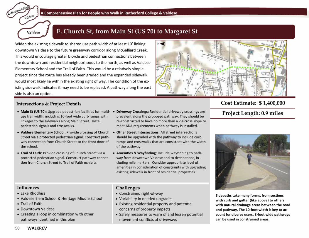
50 WALKRCV
A Comprehensive Plan for People who Walk in Rutherford College & Valdese
Widen the existing sidewalk to shared use path width of at least 10’ linking
downtown Valdese to the future greenway corridor along McGalliard Creek.
This would encourage greater bicycle and pedestrian connections between
the downtown and residential neighborhoods to the north, as well as Valdese
Elementary School and the Trail of Faith. This would be a relatively simple
project since the route has already been graded and the expanded sidewalk
would most likely lie within the existing right of way. The condition of the ex-
isting sidewalk indicates it may need to be replaced. A pathway along the east
side is also an option.
E. Church St, from Main St (US 70) to Margaret St
Intersections & Project Details
Main St (US 70): Upgrade pedestrian facilities for multi-use trail width, including 10-foot wide curb ramps with linkages to the sidewalks along Main Street. Install pedestrian signals and crosswalks.
Valdese Elementary School: Provide crossing of Church Street via a protected pedestrian signal. Construct path-way connection from Church Street to the front door of the school.
Trail of Faith: Provide crossing of Church Street via a protected pedestrian signal. Construct pathway connec-tion from Church Street to Trail of Faith exhibits.
Driveway Crossings: Residential driveway crossings are prevalent along the proposed pathway. They should be re-constructed to have no more than a 2% cross slope to meet ADA requirements when pathway is installed.
Other Street Intersections: All street intersections should be upgraded with the pathway to include curb ramps and crosswalks that are consistent with the width of the pathway.
Amenities & Wayfinding: Include wayfinding to path-way from downtown Valdese and to destinations, in-cluding mile markers. Consider appropriate level of amenities in consideration of constraints with upgrading existing sidewalk in front of residential properties.
Influences Challenges
Cost Estimate: $ 1,400,000
Project Length: 0.9 miles
Lake Rhodhiss Valdese Elem School & Heritage Middle School Trail of Faith Downtown Valdese Creating a loop in combination with other
pathways identified in this plan
Constrained right-of-way Variability in needed upgrades Existing residential property and potential
concerns of property impacts Safely measures to warn of and lessen potential
movement conflicts at driveways
Sidepaths take many forms, from sections with curb and gutter (like above) to others with natural drainage areas between the road and pathway. The 10-foot width is key to ac-count for diverse users. 8-foot wide pathways can be used in constrained areas.
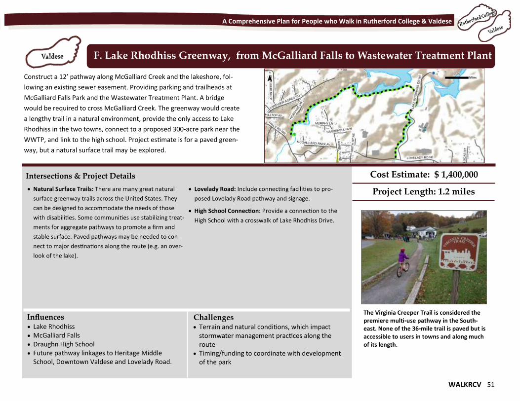
WALKRCV 51
A Comprehensive Plan for People who Walk in Rutherford College & Valdese
Construct a 12’ pathway along McGalliard Creek and the lakeshore, fol-
lowing an existing sewer easement. Providing parking and trailheads at
McGalliard Falls Park and the Wastewater Treatment Plant. A bridge
would be required to cross McGalliard Creek. The greenway would create
a lengthy trail in a natural environment, provide the only access to Lake
Rhodhiss in the two towns, connect to a proposed 300-acre park near the
WWTP, and link to the high school. Project estimate is for a paved green-
way, but a natural surface trail may be explored.
F. Lake Rhodhiss Greenway, from McGalliard Falls to Wastewater Treatment Plant
Intersections & Project Details
Natural Surface Trails: There are many great natural
surface greenway trails across the United States. They
can be designed to accommodate the needs of those
with disabilities. Some communities use stabilizing treat-
ments for aggregate pathways to promote a firm and
stable surface. Paved pathways may be needed to con-
nect to major destinations along the route (e.g. an over-
look of the lake).
Lovelady Road: Include connecting facilities to pro-
posed Lovelady Road pathway and signage.
High School Connection: Provide a connection to the
High School with a crosswalk of Lake Rhodhiss Drive.
Influences Challenges
Cost Estimate: $ 1,400,000
Project Length: 1.2 miles
Lake Rhodhiss McGalliard Falls Draughn High School Future pathway linkages to Heritage Middle
School, Downtown Valdese and Lovelady Road.
Terrain and natural conditions, which impact stormwater management practices along the route
Timing/funding to coordinate with development of the park
The Virginia Creeper Trail is considered the premiere multi-use pathway in the South-east. None of the 36-mile trail is paved but is accessible to users in towns and along much of its length.
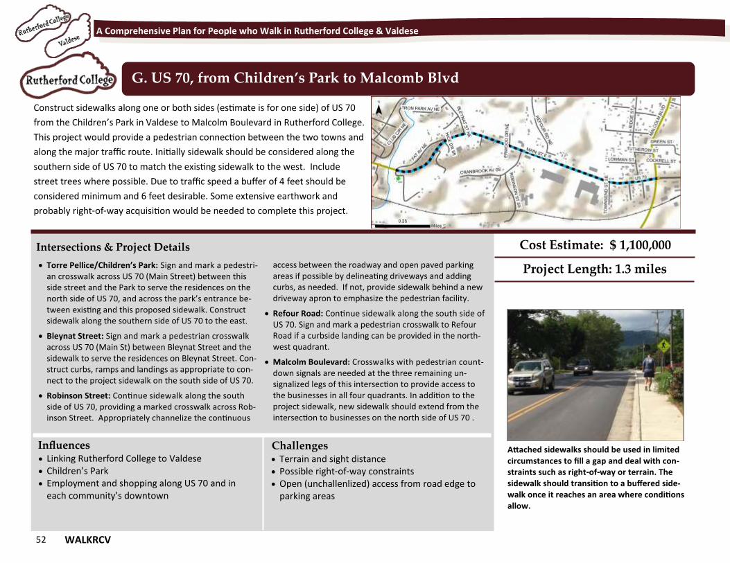
52 WALKRCV
A Comprehensive Plan for People who Walk in Rutherford College & Valdese
Construct sidewalks along one or both sides (estimate is for one side) of US 70
from the Children’s Park in Valdese to Malcolm Boulevard in Rutherford College.
This project would provide a pedestrian connection between the two towns and
along the major traffic route. Initially sidewalk should be considered along the
southern side of US 70 to match the existing sidewalk to the west. Include
street trees where possible. Due to traffic speed a buffer of 4 feet should be
considered minimum and 6 feet desirable. Some extensive earthwork and
probably right-of-way acquisition would be needed to complete this project.
G. US 70, from Children’s Park to Malcomb Blvd
Intersections & Project Details
Torre Pellice/Children’s Park: Sign and mark a pedestri-an crosswalk across US 70 (Main Street) between this side street and the Park to serve the residences on the north side of US 70, and across the park’s entrance be-tween existing and this proposed sidewalk. Construct sidewalk along the southern side of US 70 to the east.
Bleynat Street: Sign and mark a pedestrian crosswalk across US 70 (Main St) between Bleynat Street and the sidewalk to serve the residences on Bleynat Street. Con-struct curbs, ramps and landings as appropriate to con-nect to the project sidewalk on the south side of US 70.
Robinson Street: Continue sidewalk along the south side of US 70, providing a marked crosswalk across Rob-inson Street. Appropriately channelize the continuous
access between the roadway and open paved parking areas if possible by delineating driveways and adding curbs, as needed. If not, provide sidewalk behind a new driveway apron to emphasize the pedestrian facility.
Refour Road: Continue sidewalk along the south side of US 70. Sign and mark a pedestrian crosswalk to Refour Road if a curbside landing can be provided in the north-west quadrant.
Malcolm Boulevard: Crosswalks with pedestrian count-down signals are needed at the three remaining un-signalized legs of this intersection to provide access to the businesses in all four quadrants. In addition to the project sidewalk, new sidewalk should extend from the intersection to businesses on the north side of US 70 .
Influences Challenges
Cost Estimate: $ 1,100,000
Project Length: 1.3 miles
Linking Rutherford College to Valdese Children’s Park Employment and shopping along US 70 and in
each community’s downtown
Terrain and sight distance Possible right-of-way constraints Open (unchallenlized) access from road edge to
parking areas
Attached sidewalks should be used in limited circumstances to fill a gap and deal with con-straints such as right-of-way or terrain. The sidewalk should transition to a buffered side-walk once it reaches an area where conditions allow.
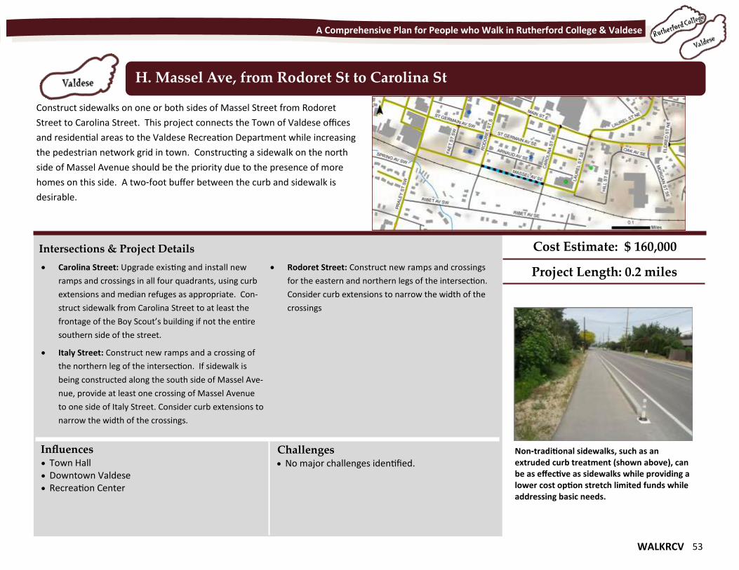
WALKRCV 53
A Comprehensive Plan for People who Walk in Rutherford College & Valdese
Construct sidewalks on one or both sides of Massel Street from Rodoret
Street to Carolina Street. This project connects the Town of Valdese offices
and residential areas to the Valdese Recreation Department while increasing
the pedestrian network grid in town. Constructing a sidewalk on the north
side of Massel Avenue should be the priority due to the presence of more
homes on this side. A two-foot buffer between the curb and sidewalk is
desirable.
H. Massel Ave, from Rodoret St to Carolina St
Intersections & Project Details
Carolina Street: Upgrade existing and install new
ramps and crossings in all four quadrants, using curb
extensions and median refuges as appropriate. Con-
struct sidewalk from Carolina Street to at least the
frontage of the Boy Scout’s building if not the entire
southern side of the street.
Italy Street: Construct new ramps and a crossing of
the northern leg of the intersection. If sidewalk is
being constructed along the south side of Massel Ave-
nue, provide at least one crossing of Massel Avenue
to one side of Italy Street. Consider curb extensions to
narrow the width of the crossings.
Rodoret Street: Construct new ramps and crossings
for the eastern and northern legs of the intersection.
Consider curb extensions to narrow the width of the
crossings
Influences Challenges
Cost Estimate: $ 160,000
Project Length: 0.2 miles
Town Hall Downtown Valdese Recreation Center
No major challenges identified. Non-traditional sidewalks, such as an extruded curb treatment (shown above), can be as effective as sidewalks while providing a lower cost option stretch limited funds while addressing basic needs.
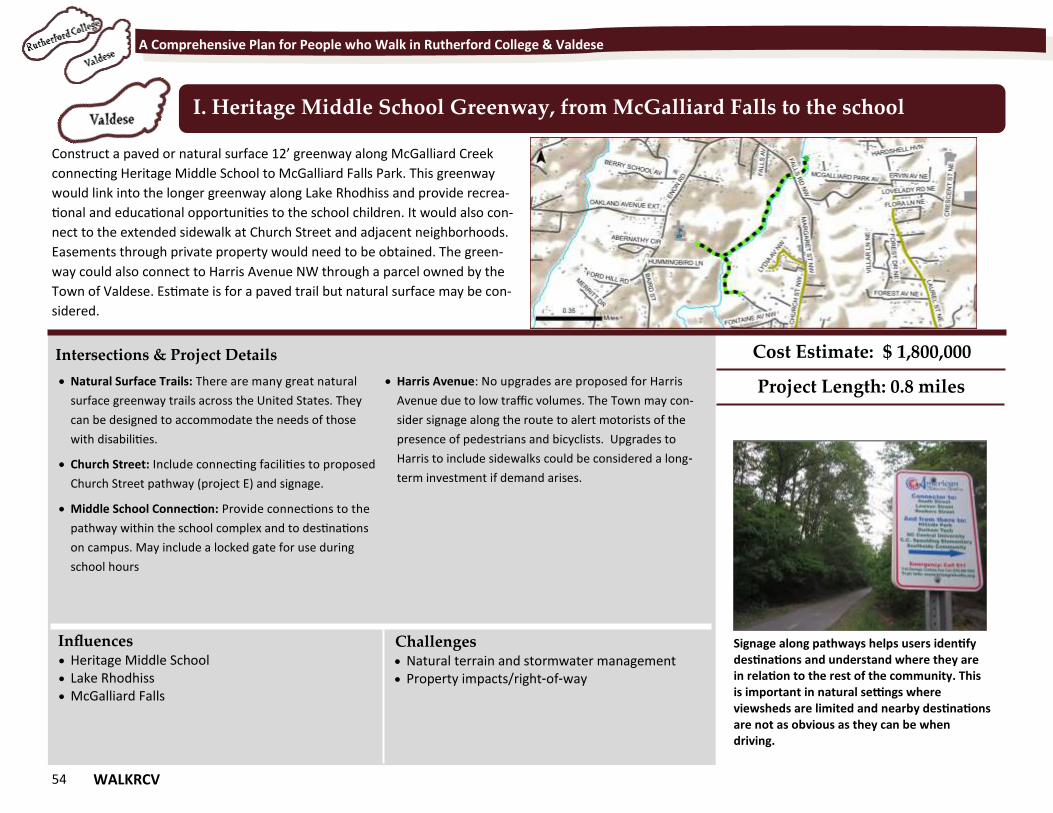
54 WALKRCV
A Comprehensive Plan for People who Walk in Rutherford College & Valdese
Construct a paved or natural surface 12’ greenway along McGalliard Creek
connecting Heritage Middle School to McGalliard Falls Park. This greenway
would link into the longer greenway along Lake Rhodhiss and provide recrea-
tional and educational opportunities to the school children. It would also con-
nect to the extended sidewalk at Church Street and adjacent neighborhoods.
Easements through private property would need to be obtained. The green-
way could also connect to Harris Avenue NW through a parcel owned by the
Town of Valdese. Estimate is for a paved trail but natural surface may be con-
sidered.
I. Heritage Middle School Greenway, from McGalliard Falls to the school
Intersections & Project Details
Natural Surface Trails: There are many great natural
surface greenway trails across the United States. They
can be designed to accommodate the needs of those
with disabilities.
Church Street: Include connecting facilities to proposed
Church Street pathway (project E) and signage.
Middle School Connection: Provide connections to the
pathway within the school complex and to destinations
on campus. May include a locked gate for use during
school hours
Harris Avenue: No upgrades are proposed for Harris
Avenue due to low traffic volumes. The Town may con-
sider signage along the route to alert motorists of the
presence of pedestrians and bicyclists. Upgrades to
Harris to include sidewalks could be considered a long-
term investment if demand arises.
Influences Challenges
Cost Estimate: $ 1,800,000
Project Length: 0.8 miles
Heritage Middle School Lake Rhodhiss McGalliard Falls
Natural terrain and stormwater management Property impacts/right-of-way
Signage along pathways helps users identify destinations and understand where they are in relation to the rest of the community. This is important in natural settings where viewsheds are limited and nearby destinations are not as obvious as they can be when driving.
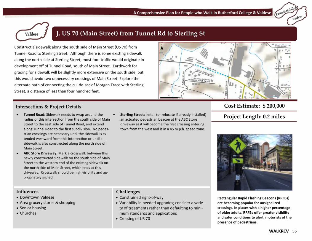
WALKRCV 55
A Comprehensive Plan for People who Walk in Rutherford College & Valdese
Construct a sidewalk along the south side of Main Street (US 70) from
Tunnel Road to Sterling Street. Although there is some existing sidewalk
along the north side at Sterling Street, most foot traffic would originate in
development off of Tunnel Road, south of Main Street. Earthwork for
grading for sidewalk will be slightly more extensive on the south side, but
this would avoid two unnecessary crossings of Main Street. Explore the
alternate path of connecting the cul-de-sac of Morgan Trace with Sterling
Street, a distance of less than four hundred feet.
J. US 70 (Main Street) from Tunnel Rd to Sterling St
Intersections & Project Details
Tunnel Road: Sidewalk needs to wrap around the radius of this intersection from the south side of Main Street to the east side of Tunnel Road, and extend along Tunnel Road to the first subdivision. No pedes-trian crossings are necessary until the sidewalk is ex-tended westward from this intersection or until a sidewalk is also constructed along the north side of Main Street.
ABC Store Driveway: Mark a crosswalk between this newly constructed sidewalk on the south side of Main Street to the western end of the existing sidewalk on the north side of Main Street, which ends at this driveway. Crosswalk should be high visibility and ap-propriately signed.
Sterling Street: Install (or relocate if already installed) an actuated pedestrian beacon at the ABC Store driveway as it will become the first crossing entering town from the west and is in a 45 m.p.h. speed zone.
Influences Challenges
Cost Estimate: $ 200,000
Project Length: 0.2 miles
Downtown Valdese Area grocery stores & shopping Senior housing Churches
Constrained right-of-way Variability in needed upgrades; consider a varie-
ty of treatments rather than defaulting to mini-mum standards and applications
Crossing of US 70
Rectangular Rapid Flashing Beacons (RRFBs) are becoming popular for unsignalized crossings. In places with a higher percentage of older adults, RRFBs offer greater visibility and safer conditions to alert motorists of the presence of pedestrians.
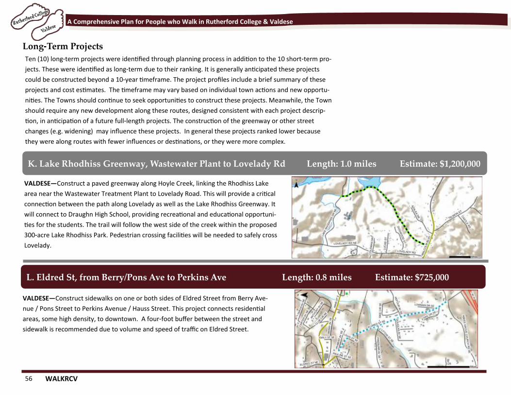
56 WALKRCV
A Comprehensive Plan for People who Walk in Rutherford College & Valdese
Long-Term Projects
VALDESE—Construct a paved greenway along Hoyle Creek, linking the Rhodhiss Lake
area near the Wastewater Treatment Plant to Lovelady Road. This will provide a critical
connection between the path along Lovelady as well as the Lake Rhodhiss Greenway. It
will connect to Draughn High School, providing recreational and educational opportuni-
ties for the students. The trail will follow the west side of the creek within the proposed
300-acre Lake Rhodhiss Park. Pedestrian crossing facilities will be needed to safely cross
Lovelady.
K. Lake Rhodhiss Greenway, Wastewater Plant to Lovelady Rd Length: 1.0 miles Estimate: $1,200,000
VALDESE—Construct sidewalks on one or both sides of Eldred Street from Berry Ave-
nue / Pons Street to Perkins Avenue / Hauss Street. This project connects residential
areas, some high density, to downtown. A four-foot buffer between the street and
sidewalk is recommended due to volume and speed of traffic on Eldred Street.
L. Eldred St, from Berry/Pons Ave to Perkins Ave Length: 0.8 miles Estimate: $725,000
Ten (10) long-term projects were identified through planning process in addition to the 10 short-term pro-
jects. These were identified as long-term due to their ranking. It is generally anticipated these projects
could be constructed beyond a 10-year timeframe. The project profiles include a brief summary of these
projects and cost estimates. The timeframe may vary based on individual town actions and new opportu-
nities. The Towns should continue to seek opportunities to construct these projects. Meanwhile, the Town
should require any new development along these routes, designed consistent with each project descrip-
tion, in anticipation of a future full-length projects. The construction of the greenway or other street
changes (e.g. widening) may influence these projects. In general these projects ranked lower because
they were along routes with fewer influences or destinations, or they were more complex.
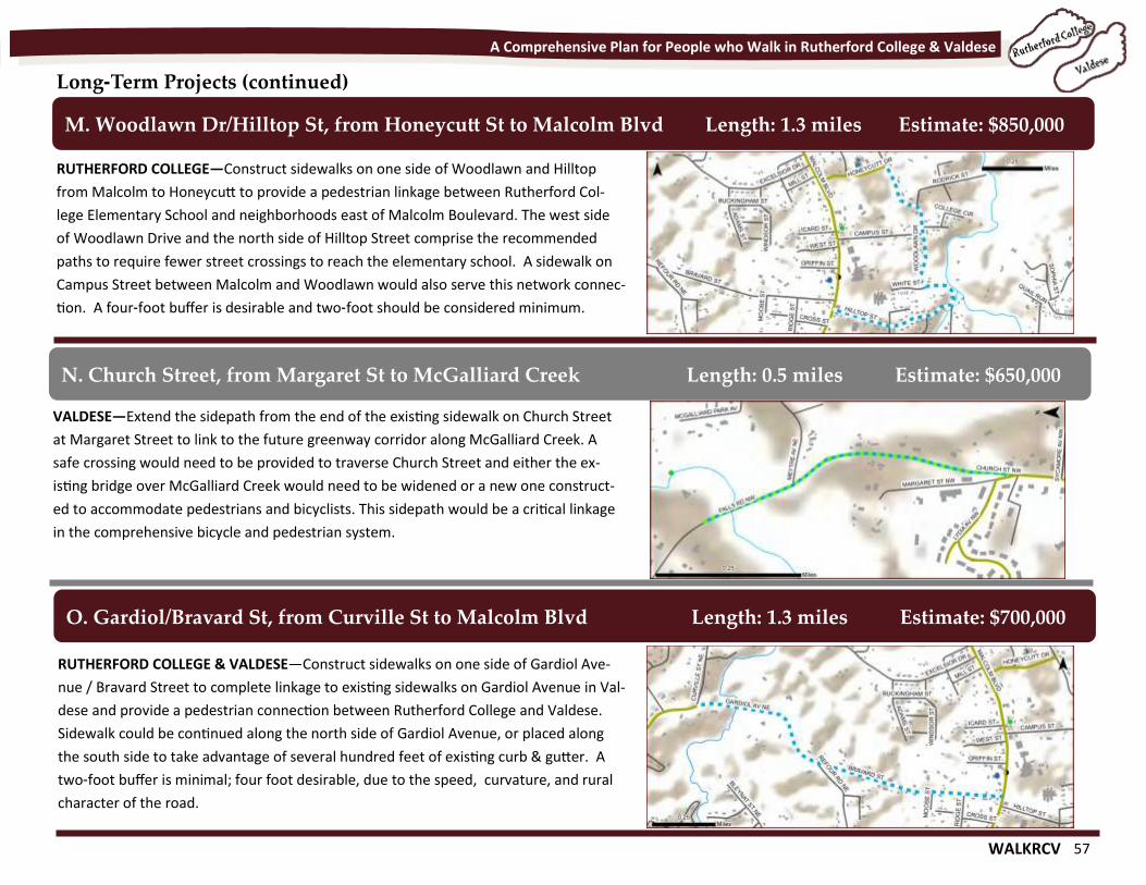
WALKRCV 57
A Comprehensive Plan for People who Walk in Rutherford College & Valdese
Long-Term Projects (continued)
RUTHERFORD COLLEGE—Construct sidewalks on one side of Woodlawn and Hilltop
from Malcolm to Honeycutt to provide a pedestrian linkage between Rutherford Col-
lege Elementary School and neighborhoods east of Malcolm Boulevard. The west side
of Woodlawn Drive and the north side of Hilltop Street comprise the recommended
paths to require fewer street crossings to reach the elementary school. A sidewalk on
Campus Street between Malcolm and Woodlawn would also serve this network connec-
tion. A four-foot buffer is desirable and two-foot should be considered minimum.
M. Woodlawn Dr/Hilltop St, from Honeycutt St to Malcolm Blvd Length: 1.3 miles Estimate: $850,000
VALDESE—Extend the sidepath from the end of the existing sidewalk on Church Street
at Margaret Street to link to the future greenway corridor along McGalliard Creek. A
safe crossing would need to be provided to traverse Church Street and either the ex-
isting bridge over McGalliard Creek would need to be widened or a new one construct-
ed to accommodate pedestrians and bicyclists. This sidepath would be a critical linkage
in the comprehensive bicycle and pedestrian system.
N. Church Street, from Margaret St to McGalliard Creek Length: 0.5 miles Estimate: $650,000
RUTHERFORD COLLEGE & VALDESE—Construct sidewalks on one side of Gardiol Ave-
nue / Bravard Street to complete linkage to existing sidewalks on Gardiol Avenue in Val-
dese and provide a pedestrian connection between Rutherford College and Valdese.
Sidewalk could be continued along the north side of Gardiol Avenue, or placed along
the south side to take advantage of several hundred feet of existing curb & gutter. A
two-foot buffer is minimal; four foot desirable, due to the speed, curvature, and rural
character of the road.
O. Gardiol/Bravard St, from Curville St to Malcolm Blvd Length: 1.3 miles Estimate: $700,000
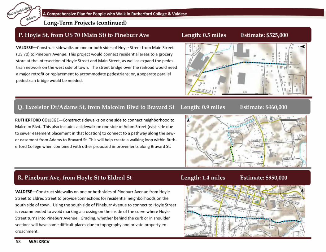
58 WALKRCV
A Comprehensive Plan for People who Walk in Rutherford College & Valdese
Long-Term Projects (continued)
VALDESE—Construct sidewalks on one or both sides of Hoyle Street from Main Street
(US 70) to Pineburr Avenue. This project would connect residential areas to a grocery
store at the intersection of Hoyle Street and Main Street, as well as expand the pedes-
trian network on the west side of town. The street bridge over the railroad would need
a major retrofit or replacement to accommodate pedestrians; or, a separate parallel
pedestrian bridge would be needed.
P. Hoyle St, from US 70 (Main St) to Pineburr Ave Length: 0.5 miles Estimate: $525,000
RUTHERFORD COLLEGE—Construct sidewalks on one side to connect neighborhood to
Malcolm Blvd. This also includes a sidewalk on one side of Adam Street (east side due
to sewer easement placement in that location) to connect to a pathway along the sew-
er easement from Adams to Bravard St. This will help create a walking loop within Ruth-
erford College when combined with other proposed improvements along Bravard St.
Q. Excelsior Dr/Adams St, from Malcolm Blvd to Bravard St Length: 0.9 miles Estimate: $460,000
VALDESE—Construct sidewalks on one or both sides of Pineburr Avenue from Hoyle
Street to Eldred Street to provide connections for residential neighborhoods on the
south side of town. Using the south side of Pineburr Avenue to connect to Hoyle Street
is recommended to avoid marking a crossing on the inside of the curve where Hoyle
Street turns into Pineburr Avenue. Grading, whether behind the curb or in shoulder
sections will have some difficult places due to topography and private property en-
croachment.
R. Pineburr Ave, from Hoyle St to Eldred St Length: 1.4 miles Estimate: $950,000
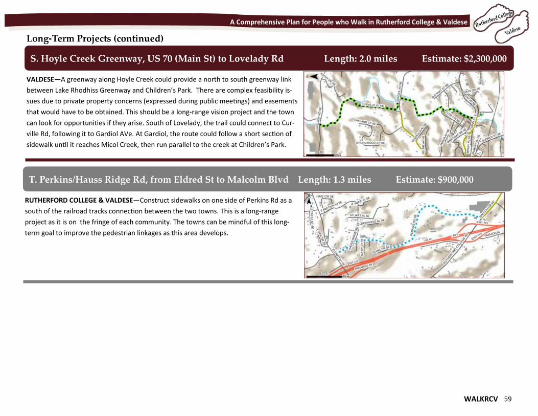
WALKRCV 59
A Comprehensive Plan for People who Walk in Rutherford College & Valdese
Long-Term Projects (continued)
VALDESE—A greenway along Hoyle Creek could provide a north to south greenway link
between Lake Rhodhiss Greenway and Children’s Park. There are complex feasibility is-
sues due to private property concerns (expressed during public meetings) and easements
that would have to be obtained. This should be a long-range vision project and the town
can look for opportunities if they arise. South of Lovelady, the trail could connect to Cur-
ville Rd, following it to Gardiol AVe. At Gardiol, the route could follow a short section of
sidewalk until it reaches Micol Creek, then run parallel to the creek at Children’s Park.
S. Hoyle Creek Greenway, US 70 (Main St) to Lovelady Rd Length: 2.0 miles Estimate: $2,300,000
RUTHERFORD COLLEGE & VALDESE—Construct sidewalks on one side of Perkins Rd as a
south of the railroad tracks connection between the two towns. This is a long-range
project as it is on the fringe of each community. The towns can be mindful of this long-
term goal to improve the pedestrian linkages as this area develops.
T. Perkins/Hauss Ridge Rd, from Eldred St to Malcolm Blvd Length: 1.3 miles Estimate: $900,000
60 WALKRCV
A Comprehensive Plan for People who Walk in Rutherford College & Valdese
This page intentionally blank.
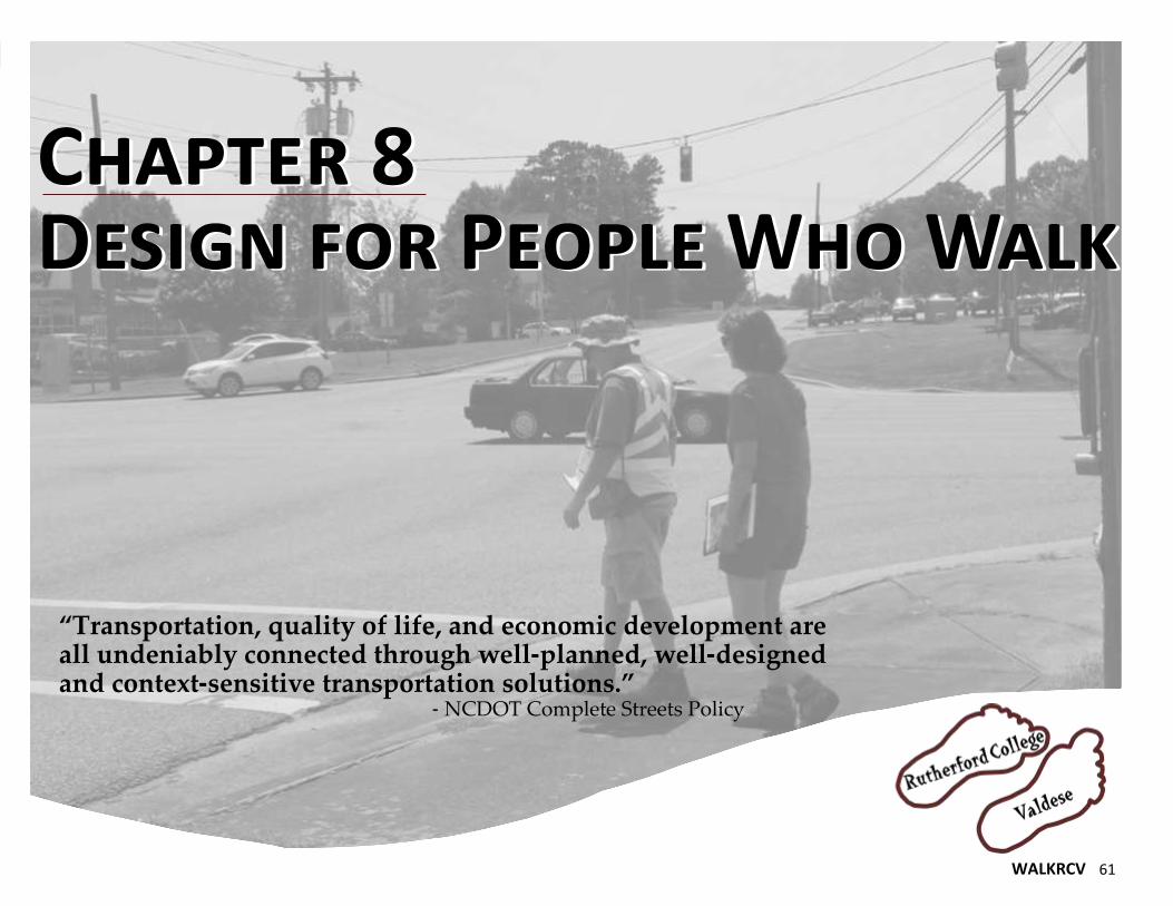
WALKRCV 61
Chapter 8 Design for People Who Walk
Chapter 8 Design for People Who Walk
“Transportation, quality of life, and economic development are all undeniably connected through well-planned, well-designed and context-sensitive transportation solutions.” - NCDOT Complete Streets Policy
62 WALKRCV
A Comprehensive Plan for People who Walk in Rutherford College & Valdese
Design for People who Walk Pedestrian facility use is a function of a variety of factors,
including the connectivity of the facilities, their safety,
their convenience, and their comfort. For this reason,
pedestrian facility design should be thoughtful and sensi-
tive to the needs of its users. By following the guidelines
provided in this section for sidewalk, crossing, and trail
design, as well as other items associated with pedestrian
facilities, Rutherford College and Valdese should be able
to create a built environment that will promote walking
and increase the number of pedestrians in the area.
This section is intended to be a general reference for
sidewalk and pedestrian facilities as well as a guide for
various “Best Practices” that apply to special pedestrian
situations. This section is not exhaustive but rather it
refers to various national and state guidelines to respond
to specific situations that may arise.
Currently, the Towns have few standards for pedestrian
facilities – sidewalks, crosswalks, and other pedestrian-
related amenities are constructed on an ad-hoc, as-
needed basis. This section of the Plan is important be-
cause it provides a consistent set of guidelines to help
ensure that safety and accessibility goals are realized
and clear expectations are set for drivers and pedestri-
ans.
Design standards are constantly changing and evolving,
so it is recommended that the Town confer with NCDOT
and various national resources guides (included on the
final page of this chapter) whenever embarking on new
facilities.
Design Guidance There are a variety of sources for design guidance for pedes-
trian facilities, including the following:
NCDOT Roadway Standard Drawings (2012);
NCDOT Complete Streets Planning and Design Guidelines
(2012);
AASHTO Guide for the Planning, Design, and Operation of
Pedestrian Facilities (2004);
Manual on Uniform Traffic Control Devices (MUTCD);
US Access Board Guidelines for Pedestrians Facilities in
Public Right-of-Way (2011); and
Numerous Federal Highway Administration publications.
It is best to refer to these design publications when special
conditions arise in the design of projects. Every effort should
be made to address the requirements, particularly those con-
cerning ADA, to maximum extent possible even if it means
additional right-of-way or construction is needed. State and
local governments are required to comply with ADA in the
construction or retrofit of projects in public rights-of-way.
Sidewalks The typical sidewalk is least five feet in width, made of con-
crete, and placed along roadways at least three feet behind
the curbline (a 5’ buffer is preferable). In general, the width
of sidewalks should accommodate two persons walking past
one another, a width generally perceived to be five feet, at a
minimum. Other circumstances that may require additional
sidewalk width are to accommodate:
1. High pedestrian volumes and places where sidewalks
serve functions in addition to pedestrian travel, such as in
a central business district;
2. The overhang of parked vehicles from off-street or an-
gled on-street parking areas; and
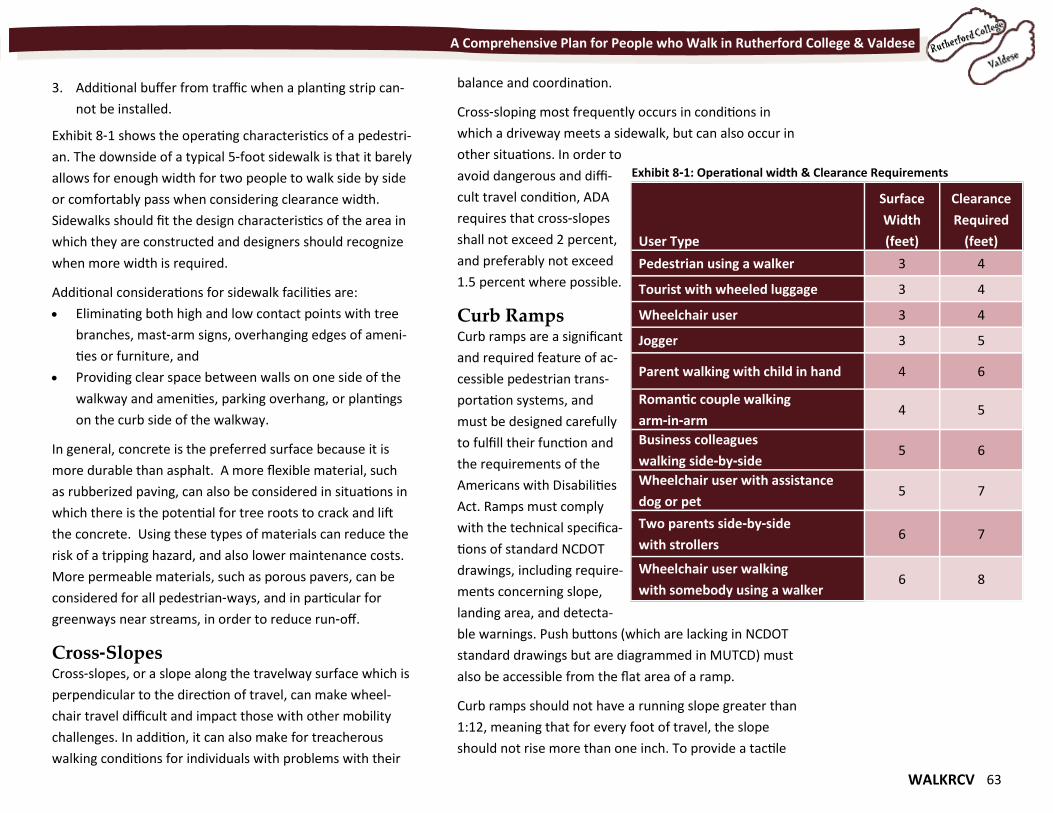
WALKRCV 63
A Comprehensive Plan for People who Walk in Rutherford College & Valdese
3. Additional buffer from traffic when a planting strip can-
not be installed.
Exhibit 8-1 shows the operating characteristics of a pedestri-
an. The downside of a typical 5-foot sidewalk is that it barely
allows for enough width for two people to walk side by side
or comfortably pass when considering clearance width.
Sidewalks should fit the design characteristics of the area in
which they are constructed and designers should recognize
when more width is required.
Additional considerations for sidewalk facilities are:
Eliminating both high and low contact points with tree
branches, mast-arm signs, overhanging edges of ameni-
ties or furniture, and
Providing clear space between walls on one side of the
walkway and amenities, parking overhang, or plantings
on the curb side of the walkway.
In general, concrete is the preferred surface because it is
more durable than asphalt. A more flexible material, such
as rubberized paving, can also be considered in situations in
which there is the potential for tree roots to crack and lift
the concrete. Using these types of materials can reduce the
risk of a tripping hazard, and also lower maintenance costs.
More permeable materials, such as porous pavers, can be
considered for all pedestrian-ways, and in particular for
greenways near streams, in order to reduce run-off.
Cross-Slopes Cross-slopes, or a slope along the travelway surface which is
perpendicular to the direction of travel, can make wheel-
chair travel difficult and impact those with other mobility
challenges. In addition, it can also make for treacherous
walking conditions for individuals with problems with their
balance and coordination.
Cross-sloping most frequently occurs in conditions in
which a driveway meets a sidewalk, but can also occur in
other situations. In order to
avoid dangerous and diffi-
cult travel condition, ADA
requires that cross-slopes
shall not exceed 2 percent,
and preferably not exceed
1.5 percent where possible.
Curb Ramps Curb ramps are a significant
and required feature of ac-
cessible pedestrian trans-
portation systems, and
must be designed carefully
to fulfill their function and
the requirements of the
Americans with Disabilities
Act. Ramps must comply
with the technical specifica-
tions of standard NCDOT
drawings, including require-
ments concerning slope,
landing area, and detecta-
ble warnings. Push buttons (which are lacking in NCDOT
standard drawings but are diagrammed in MUTCD) must
also be accessible from the flat area of a ramp.
Curb ramps should not have a running slope greater than
1:12, meaning that for every foot of travel, the slope
should not rise more than one inch. To provide a tactile
User Type
Surface
Width
(feet)
Clearance
Required
(feet)
Pedestrian using a walker 3 4
Tourist with wheeled luggage 3 4
Wheelchair user 3 4
Jogger 3 5
Parent walking with child in hand 4 6
Romantic couple walking
arm-in-arm 4 5
Business colleagues
walking side-by-side 5 6
Wheelchair user with assistance
dog or pet 5 7
Two parents side-by-side
with strollers 6 7
Wheelchair user walking
with somebody using a walker 6 8
Exhibit 8-1: Operational width & Clearance Requirements
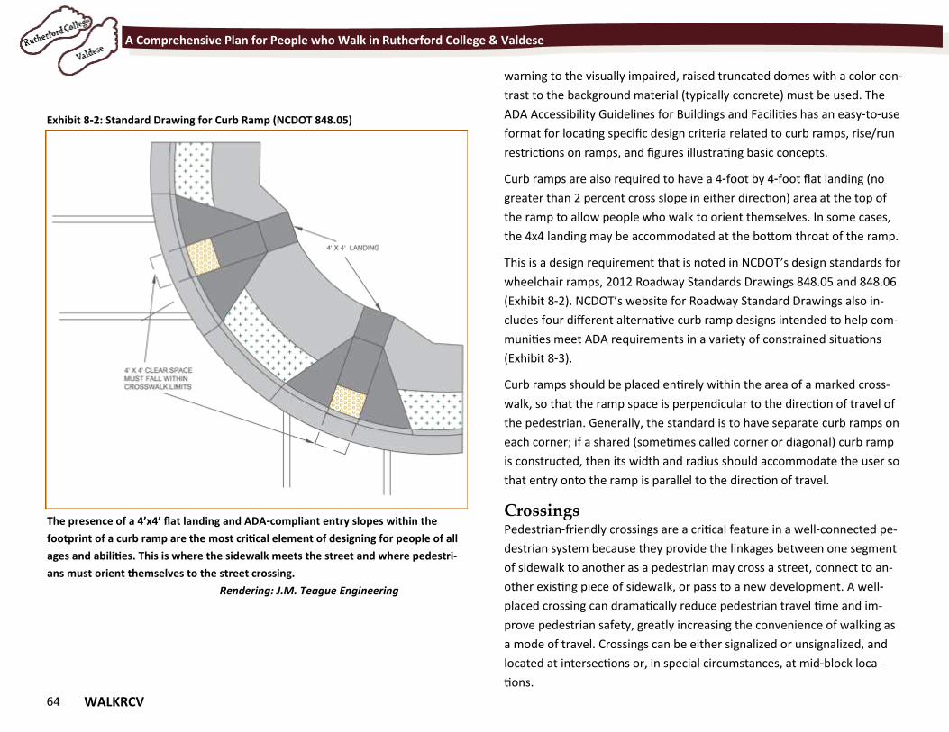
64 WALKRCV
A Comprehensive Plan for People who Walk in Rutherford College & Valdese
warning to the visually impaired, raised truncated domes with a color con-
trast to the background material (typically concrete) must be used. The
ADA Accessibility Guidelines for Buildings and Facilities has an easy-to-use
format for locating specific design criteria related to curb ramps, rise/run
restrictions on ramps, and figures illustrating basic concepts.
Curb ramps are also required to have a 4-foot by 4-foot flat landing (no
greater than 2 percent cross slope in either direction) area at the top of
the ramp to allow people who walk to orient themselves. In some cases,
the 4x4 landing may be accommodated at the bottom throat of the ramp.
This is a design requirement that is noted in NCDOT’s design standards for
wheelchair ramps, 2012 Roadway Standards Drawings 848.05 and 848.06
(Exhibit 8-2). NCDOT’s website for Roadway Standard Drawings also in-
cludes four different alternative curb ramp designs intended to help com-
munities meet ADA requirements in a variety of constrained situations
(Exhibit 8-3).
Curb ramps should be placed entirely within the area of a marked cross-
walk, so that the ramp space is perpendicular to the direction of travel of
the pedestrian. Generally, the standard is to have separate curb ramps on
each corner; if a shared (sometimes called corner or diagonal) curb ramp
is constructed, then its width and radius should accommodate the user so
that entry onto the ramp is parallel to the direction of travel.
Crossings Pedestrian-friendly crossings are a critical feature in a well-connected pe-
destrian system because they provide the linkages between one segment
of sidewalk to another as a pedestrian may cross a street, connect to an-
other existing piece of sidewalk, or pass to a new development. A well-
placed crossing can dramatically reduce pedestrian travel time and im-
prove pedestrian safety, greatly increasing the convenience of walking as
a mode of travel. Crossings can be either signalized or unsignalized, and
located at intersections or, in special circumstances, at mid-block loca-
tions.
Exhibit 8-2: Standard Drawing for Curb Ramp (NCDOT 848.05)
The presence of a 4’x4’ flat landing and ADA-compliant entry slopes within the
footprint of a curb ramp are the most critical element of designing for people of all
ages and abilities. This is where the sidewalk meets the street and where pedestri-
ans must orient themselves to the street crossing.
Rendering: J.M. Teague Engineering
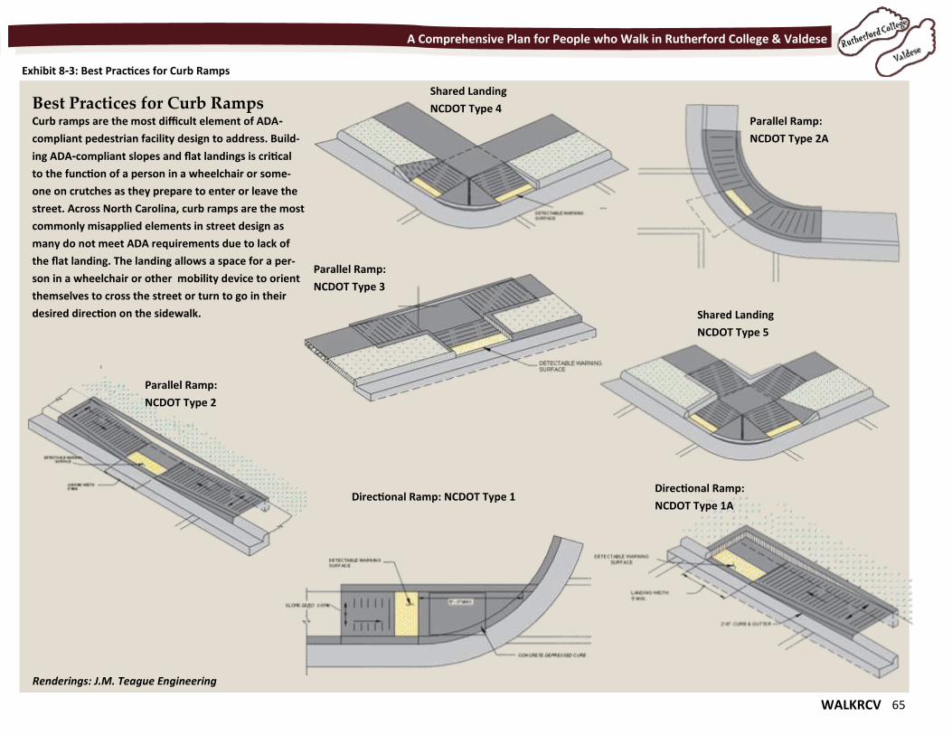
WALKRCV 65
A Comprehensive Plan for People who Walk in Rutherford College & Valdese
Exhibit 8-3: Best Practices for Curb Ramps
Best Practices for Curb Ramps Curb ramps are the most difficult element of ADA-
compliant pedestrian facility design to address. Build-
ing ADA-compliant slopes and flat landings is critical
to the function of a person in a wheelchair or some-
one on crutches as they prepare to enter or leave the
street. Across North Carolina, curb ramps are the most
commonly misapplied elements in street design as
many do not meet ADA requirements due to lack of
the flat landing. The landing allows a space for a per-
son in a wheelchair or other mobility device to orient
themselves to cross the street or turn to go in their
desired direction on the sidewalk.
Directional Ramp:
NCDOT Type 1A Directional Ramp: NCDOT Type 1
Parallel Ramp:
NCDOT Type 2A
Parallel Ramp:
NCDOT Type 2
Parallel Ramp:
NCDOT Type 3
Shared Landing
NCDOT Type 4
Shared Landing
NCDOT Type 5
Renderings: J.M. Teague Engineering
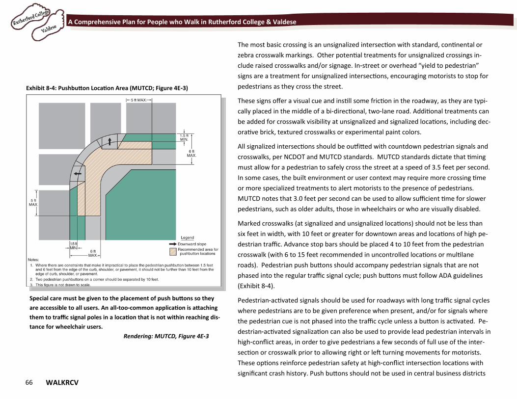
66 WALKRCV
A Comprehensive Plan for People who Walk in Rutherford College & Valdese
The most basic crossing is an unsignalized intersection with standard, continental or
zebra crosswalk markings. Other potential treatments for unsignalized crossings in-
clude raised crosswalks and/or signage. In-street or overhead “yield to pedestrian”
signs are a treatment for unsignalized intersections, encouraging motorists to stop for
pedestrians as they cross the street.
These signs offer a visual cue and instill some friction in the roadway, as they are typi-
cally placed in the middle of a bi-directional, two-lane road. Additional treatments can
be added for crosswalk visibility at unsignalized and signalized locations, including dec-
orative brick, textured crosswalks or experimental paint colors.
All signalized intersections should be outfitted with countdown pedestrian signals and
crosswalks, per NCDOT and MUTCD standards. MUTCD standards dictate that timing
must allow for a pedestrian to safely cross the street at a speed of 3.5 feet per second.
In some cases, the built environment or user context may require more crossing time
or more specialized treatments to alert motorists to the presence of pedestrians.
MUTCD notes that 3.0 feet per second can be used to allow sufficient time for slower
pedestrians, such as older adults, those in wheelchairs or who are visually disabled.
Marked crosswalks (at signalized and unsignalized locations) should not be less than
six feet in width, with 10 feet or greater for downtown areas and locations of high pe-
destrian traffic. Advance stop bars should be placed 4 to 10 feet from the pedestrian
crosswalk (with 6 to 15 feet recommended in uncontrolled locations or multilane
roads). Pedestrian push buttons should accompany pedestrian signals that are not
phased into the regular traffic signal cycle; push buttons must follow ADA guidelines
(Exhibit 8-4).
Pedestrian-activated signals should be used for roadways with long traffic signal cycles
where pedestrians are to be given preference when present, and/or for signals where
the pedestrian cue is not phased into the traffic cycle unless a button is activated. Pe-
destrian-activated signalization can also be used to provide lead pedestrian intervals in
high-conflict areas, in order to give pedestrians a few seconds of full use of the inter-
section or crosswalk prior to allowing right or left turning movements for motorists.
These options reinforce pedestrian safety at high-conflict intersection locations with
significant crash history. Push buttons should not be used in central business districts
Exhibit 8-4: Pushbutton Location Area (MUTCD; Figure 4E-3)
Special care must be given to the placement of push buttons so they
are accessible to all users. An all-too-common application is attaching
them to traffic signal poles in a location that is not within reaching dis-
tance for wheelchair users.
Rendering: MUTCD, Figure 4E-3
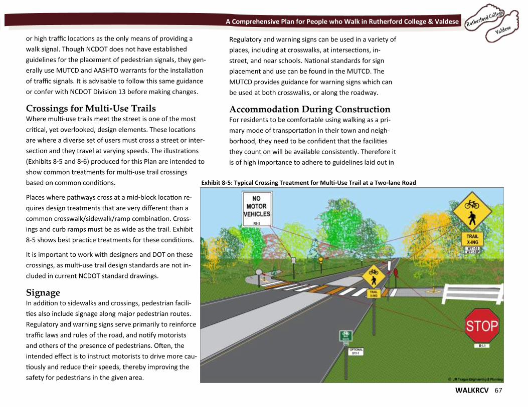
WALKRCV 67
A Comprehensive Plan for People who Walk in Rutherford College & Valdese
or high traffic locations as the only means of providing a
walk signal. Though NCDOT does not have established
guidelines for the placement of pedestrian signals, they gen-
erally use MUTCD and AASHTO warrants for the installation
of traffic signals. It is advisable to follow this same guidance
or confer with NCDOT Division 13 before making changes.
Crossings for Multi-Use Trails Where multi-use trails meet the street is one of the most
critical, yet overlooked, design elements. These locations
are where a diverse set of users must cross a street or inter-
section and they travel at varying speeds. The illustrations
(Exhibits 8-5 and 8-6) produced for this Plan are intended to
show common treatments for multi-use trail crossings
based on common conditions.
Places where pathways cross at a mid-block location re-
quires design treatments that are very different than a
common crosswalk/sidewalk/ramp combination. Cross-
ings and curb ramps must be as wide as the trail. Exhibit
8-5 shows best practice treatments for these conditions.
It is important to work with designers and DOT on these
crossings, as multi-use trail design standards are not in-
cluded in current NCDOT standard drawings.
Signage In addition to sidewalks and crossings, pedestrian facili-
ties also include signage along major pedestrian routes.
Regulatory and warning signs serve primarily to reinforce
traffic laws and rules of the road, and notify motorists
and others of the presence of pedestrians. Often, the
intended effect is to instruct motorists to drive more cau-
tiously and reduce their speeds, thereby improving the
safety for pedestrians in the given area.
Regulatory and warning signs can be used in a variety of
places, including at crosswalks, at intersections, in-
street, and near schools. National standards for sign
placement and use can be found in the MUTCD. The
MUTCD provides guidance for warning signs which can
be used at both crosswalks, or along the roadway.
Accommodation During Construction For residents to be comfortable using walking as a pri-
mary mode of transportation in their town and neigh-
borhood, they need to be confident that the facilities
they count on will be available consistently. Therefore it
is of high importance to adhere to guidelines laid out in
Exhibit 8-5: Typical Crossing Treatment for Multi-Use Trail at a Two-lane Road
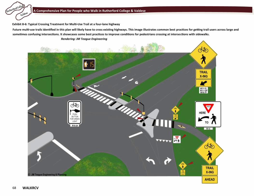
68 WALKRCV
A Comprehensive Plan for People who Walk in Rutherford College & Valdese
Exhibit 8-6: Typical Crossing Treatment for Multi-Use Trail at a four-lane highway
Future multi-use trails identified in this plan will likely have to cross existing highways. This image illustrates common best practices for getting trail users across large and
sometimes confusing intersections. It showcases some best practices to improve conditions for pedestrians crossing at intersections with sidewalks.
Rendering: JM Teague Engineering
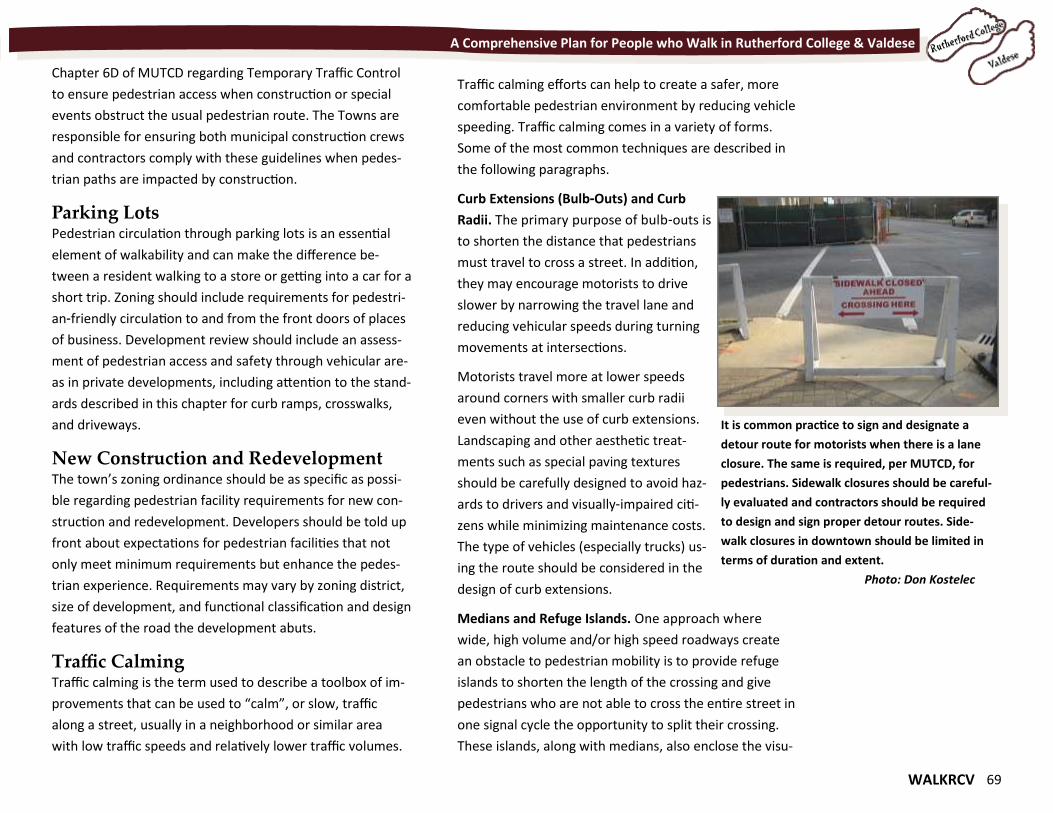
WALKRCV 69
A Comprehensive Plan for People who Walk in Rutherford College & Valdese
Chapter 6D of MUTCD regarding Temporary Traffic Control
to ensure pedestrian access when construction or special
events obstruct the usual pedestrian route. The Towns are
responsible for ensuring both municipal construction crews
and contractors comply with these guidelines when pedes-
trian paths are impacted by construction.
Parking Lots Pedestrian circulation through parking lots is an essential
element of walkability and can make the difference be-
tween a resident walking to a store or getting into a car for a
short trip. Zoning should include requirements for pedestri-
an-friendly circulation to and from the front doors of places
of business. Development review should include an assess-
ment of pedestrian access and safety through vehicular are-
as in private developments, including attention to the stand-
ards described in this chapter for curb ramps, crosswalks,
and driveways.
New Construction and Redevelopment The town’s zoning ordinance should be as specific as possi-
ble regarding pedestrian facility requirements for new con-
struction and redevelopment. Developers should be told up
front about expectations for pedestrian facilities that not
only meet minimum requirements but enhance the pedes-
trian experience. Requirements may vary by zoning district,
size of development, and functional classification and design
features of the road the development abuts.
Traffic Calming Traffic calming is the term used to describe a toolbox of im-
provements that can be used to “calm”, or slow, traffic
along a street, usually in a neighborhood or similar area
with low traffic speeds and relatively lower traffic volumes.
Traffic calming efforts can help to create a safer, more
comfortable pedestrian environment by reducing vehicle
speeding. Traffic calming comes in a variety of forms.
Some of the most common techniques are described in
the following paragraphs.
Curb Extensions (Bulb-Outs) and Curb
Radii. The primary purpose of bulb-outs is
to shorten the distance that pedestrians
must travel to cross a street. In addition,
they may encourage motorists to drive
slower by narrowing the travel lane and
reducing vehicular speeds during turning
movements at intersections.
Motorists travel more at lower speeds
around corners with smaller curb radii
even without the use of curb extensions.
Landscaping and other aesthetic treat-
ments such as special paving textures
should be carefully designed to avoid haz-
ards to drivers and visually-impaired citi-
zens while minimizing maintenance costs.
The type of vehicles (especially trucks) us-
ing the route should be considered in the
design of curb extensions.
Medians and Refuge Islands. One approach where
wide, high volume and/or high speed roadways create
an obstacle to pedestrian mobility is to provide refuge
islands to shorten the length of the crossing and give
pedestrians who are not able to cross the entire street in
one signal cycle the opportunity to split their crossing.
These islands, along with medians, also enclose the visu-
It is common practice to sign and designate a
detour route for motorists when there is a lane
closure. The same is required, per MUTCD, for
pedestrians. Sidewalk closures should be careful-
ly evaluated and contractors should be required
to design and sign proper detour routes. Side-
walk closures in downtown should be limited in
terms of duration and extent.
Photo: Don Kostelec
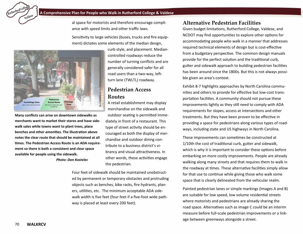
70 WALKRCV
A Comprehensive Plan for People who Walk in Rutherford College & Valdese
al space for motorists and therefore encourage compli-
ance with speed limits and other traffic laws.
Sensitivity to large vehicles (buses, trucks and fire equip-
ment) dictates some elements of the median design,
curb style, and placement. Median-
controlled roadways reduce the
number of turning conflicts and are
generally considered safer for all
road users than a two-way, left-
turn lane (TWLTL) roadway.
Pedestrian Access
Routes A retail establishment may display
merchandise on the sidewalk and
outdoor seating is permitted imme-
diately in front of a restaurant. This
type of street activity should be en-
couraged as both the display of mer-
chandise and outdoor dining con-
tribute to a business district’s vi-
brancy and visual attractiveness. In
other words, these activities engage
the pedestrian.
Four feet of sidewalk should be maintained unobstruct-
ed by permanent or temporary obstacles and protruding
objects such as benches, bike racks, fire hydrants, plan-
ers, utilities, etc. The minimum acceptable ADA side-
walk width is five feet (four feet if a five-foot wide path-
way is placed at least every 200 feet).
Alternative Pedestrian Facilities Given budget limitations, Rutherford College, Valdese, and
NCDOT may find opportunities to explore other options for
accommodating people who walk in a manner that addresses
required technical elements of design but is cost-effective
from a budgetary perspective. The common design manuals
provide for the perfect solution and the traditional curb,
gutter and sidewalk approach to building pedestrian facilities
has been around since the 1800s. But this is not always possi-
ble given an area’s context.
Exhibit 8-7 highlights approaches by North Carolina commu-
nities and others to provide for effective but low-cost trans-
portation facilities. A community should not pursue these
improvements lightly as they still need to comply with ADA
requirements for slopes, access at intersections and other
treatments. But they have been proven to be effective in
providing a space for pedestrians along various types of road-
ways, including state and US highways in North Carolina.
These improvements can sometimes be constructed at
1/10th the cost of traditional curb, gutter and sidewalk,
which is why it is important to consider these options before
embarking on more costly improvements. People are already
walking along many streets and that requires them to walk in
the roadway at times. These alternative facilities simply allow
for that use to continue while giving those who walk some
space that is clearly delineated from the vehicular realm.
Painted pedestrian lanes or simple markings (images A and B)
are suitable for low speed, low volume residential streets
where motorists and pedestrians are already sharing the
road space. Alternatives such as image C could be an interim
measure before full-scale pedestrian improvements or a link-
age between greenways alongside a street.
Many conflicts can arise on downtown sidewalks as
merchants want to market their stores and have side-
walk sales while towns want to plant trees, place
benches and other amenities. The illustration above
notes the clear route that should be maintained at all
times. The Pedestrian Access Route is an ADA require-
ment so there is both a consistent and clear space
available for people using the sidewalk.
Photo: Don Kostelec
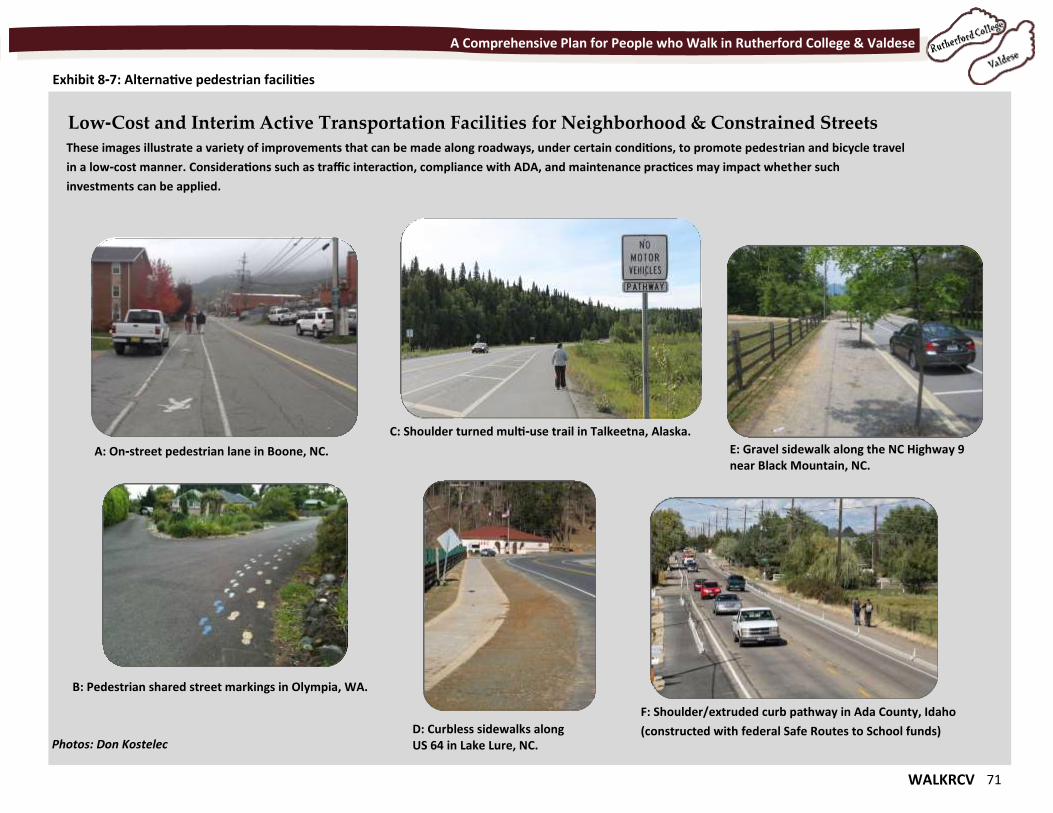
WALKRCV 71
A Comprehensive Plan for People who Walk in Rutherford College & Valdese
Exhibit 8-7: Alternative pedestrian facilities
Low-Cost and Interim Active Transportation Facilities for Neighborhood & Constrained Streets These images illustrate a variety of improvements that can be made along roadways, under certain conditions, to promote pedestrian and bicycle travel
in a low-cost manner. Considerations such as traffic interaction, compliance with ADA, and maintenance practices may impact whether such
investments can be applied.
C: Shoulder turned multi-use trail in Talkeetna, Alaska.
E: Gravel sidewalk along the NC Highway 9 near Black Mountain, NC.
B: Pedestrian shared street markings in Olympia, WA.
F: Shoulder/extruded curb pathway in Ada County, Idaho
(constructed with federal Safe Routes to School funds)
A: On-street pedestrian lane in Boone, NC.
D: Curbless sidewalks along US 64 in Lake Lure, NC. Photos: Don Kostelec
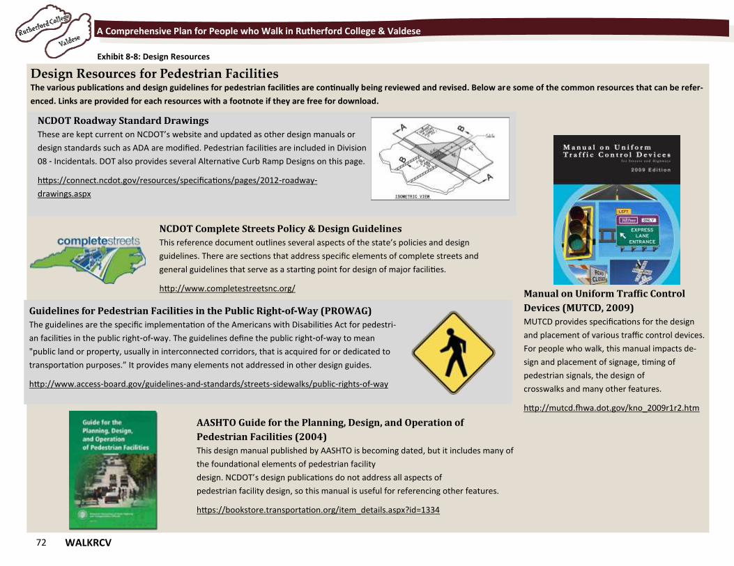
72 WALKRCV
A Comprehensive Plan for People who Walk in Rutherford College & Valdese
Exhibit 8-8: Design Resources
Design Resources for Pedestrian Facilities The various publications and design guidelines for pedestrian facilities are continually being reviewed and revised. Below are some of the common resources that can be refer-
enced. Links are provided for each resources with a footnote if they are free for download.
NCDOT Complete Streets Policy & Design Guidelines
This reference document outlines several aspects of the state’s policies and design
guidelines. There are sections that address specific elements of complete streets and
general guidelines that serve as a starting point for design of major facilities.
http://www.completestreetsnc.org/
NCDOT Roadway Standard Drawings
These are kept current on NCDOT’s website and updated as other design manuals or
design standards such as ADA are modified. Pedestrian facilities are included in Division
08 - Incidentals. DOT also provides several Alternative Curb Ramp Designs on this page.
https://connect.ncdot.gov/resources/specifications/pages/2012-roadway-
drawings.aspx
Manual on Uniform Traffic Control
Devices (MUTCD, 2009)
MUTCD provides specifications for the design
and placement of various traffic control devices.
For people who walk, this manual impacts de-
sign and placement of signage, timing of
pedestrian signals, the design of
crosswalks and many other features.
http://mutcd.fhwa.dot.gov/kno_2009r1r2.htm
AASHTO Guide for the Planning, Design, and Operation of
Pedestrian Facilities (2004)
This design manual published by AASHTO is becoming dated, but it includes many of
the foundational elements of pedestrian facility
design. NCDOT’s design publications do not address all aspects of
pedestrian facility design, so this manual is useful for referencing other features.
https://bookstore.transportation.org/item_details.aspx?id=1334
Guidelines for Pedestrian Facilities in the Public Right-of-Way (PROWAG)
The guidelines are the specific implementation of the Americans with Disabilities Act for pedestri-
an facilities in the public right-of-way. The guidelines define the public right-of-way to mean
"public land or property, usually in interconnected corridors, that is acquired for or dedicated to
transportation purposes.” It provides many elements not addressed in other design guides.
http://www.access-board.gov/guidelines-and-standards/streets-sidewalks/public-rights-of-way
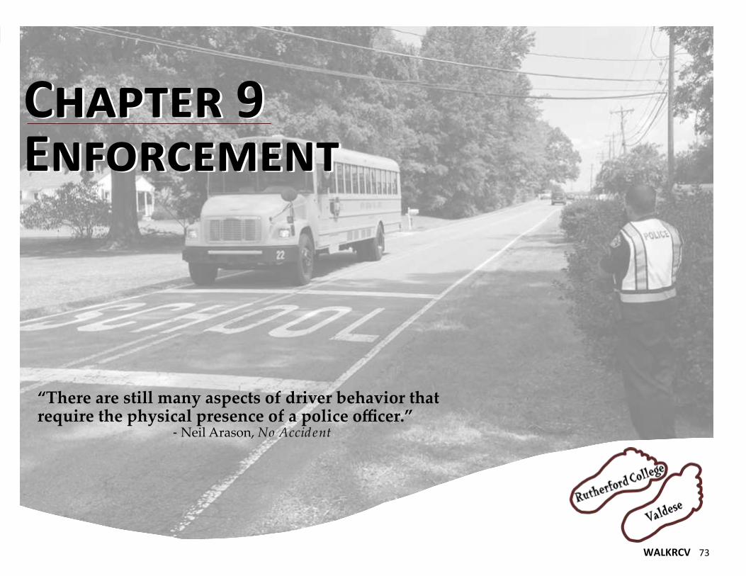
WALKRCV 73
Chapter 9 Enforcement Chapter 9 Enforcement
“There are still many aspects of driver behavior that require the physical presence of a police officer.” - Neil Arason, No Accident
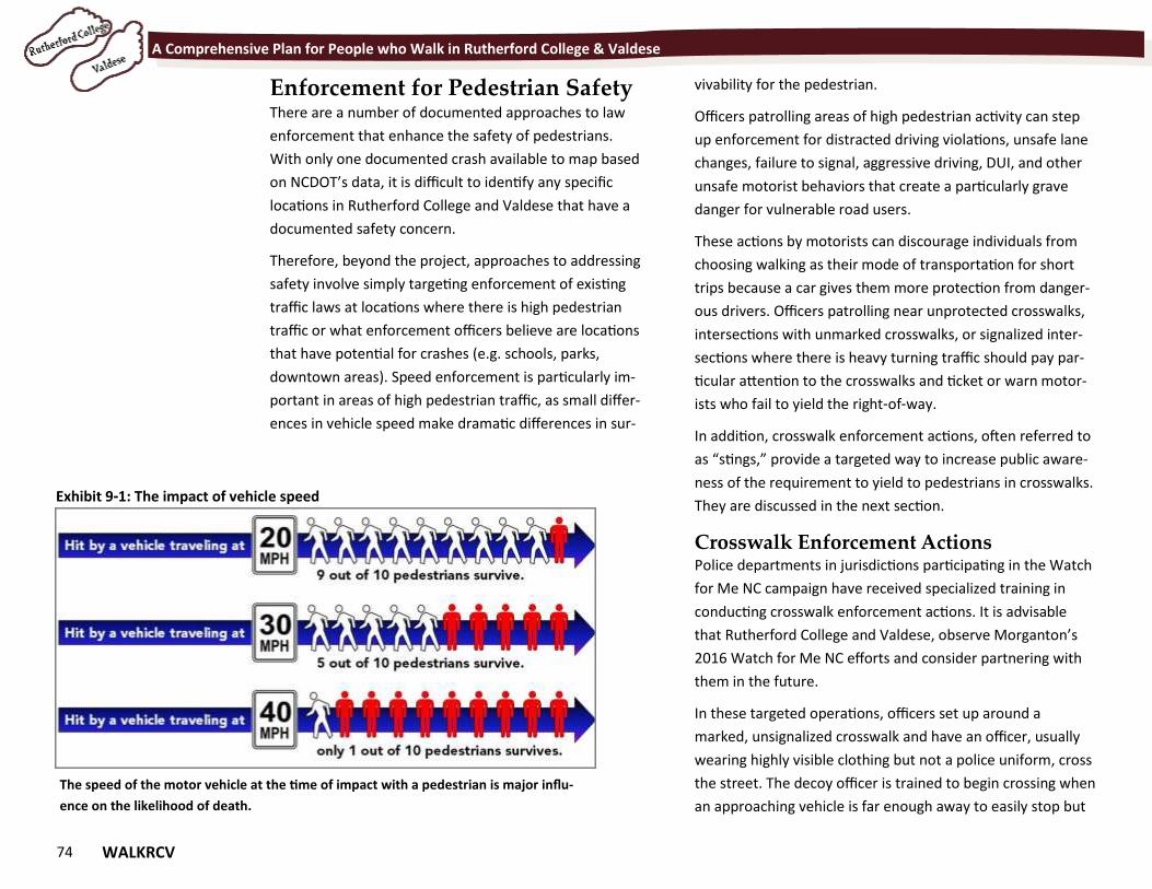
74 WALKRCV
A Comprehensive Plan for People who Walk in Rutherford College & Valdese
Enforcement for Pedestrian Safety There are a number of documented approaches to law
enforcement that enhance the safety of pedestrians.
With only one documented crash available to map based
on NCDOT’s data, it is difficult to identify any specific
locations in Rutherford College and Valdese that have a
documented safety concern.
Therefore, beyond the project, approaches to addressing
safety involve simply targeting enforcement of existing
traffic laws at locations where there is high pedestrian
traffic or what enforcement officers believe are locations
that have potential for crashes (e.g. schools, parks,
downtown areas). Speed enforcement is particularly im-
portant in areas of high pedestrian traffic, as small differ-
ences in vehicle speed make dramatic differences in sur-
vivability for the pedestrian.
Officers patrolling areas of high pedestrian activity can step
up enforcement for distracted driving violations, unsafe lane
changes, failure to signal, aggressive driving, DUI, and other
unsafe motorist behaviors that create a particularly grave
danger for vulnerable road users.
These actions by motorists can discourage individuals from
choosing walking as their mode of transportation for short
trips because a car gives them more protection from danger-
ous drivers. Officers patrolling near unprotected crosswalks,
intersections with unmarked crosswalks, or signalized inter-
sections where there is heavy turning traffic should pay par-
ticular attention to the crosswalks and ticket or warn motor-
ists who fail to yield the right-of-way.
In addition, crosswalk enforcement actions, often referred to
as “stings,” provide a targeted way to increase public aware-
ness of the requirement to yield to pedestrians in crosswalks.
They are discussed in the next section.
Crosswalk Enforcement Actions Police departments in jurisdictions participating in the Watch
for Me NC campaign have received specialized training in
conducting crosswalk enforcement actions. It is advisable
that Rutherford College and Valdese, observe Morganton’s
2016 Watch for Me NC efforts and consider partnering with
them in the future.
In these targeted operations, officers set up around a
marked, unsignalized crosswalk and have an officer, usually
wearing highly visible clothing but not a police uniform, cross
the street. The decoy officer is trained to begin crossing when
an approaching vehicle is far enough away to easily stop but
Exhibit 9-1: The impact of vehicle speed
The speed of the motor vehicle at the time of impact with a pedestrian is major influ-
ence on the likelihood of death.
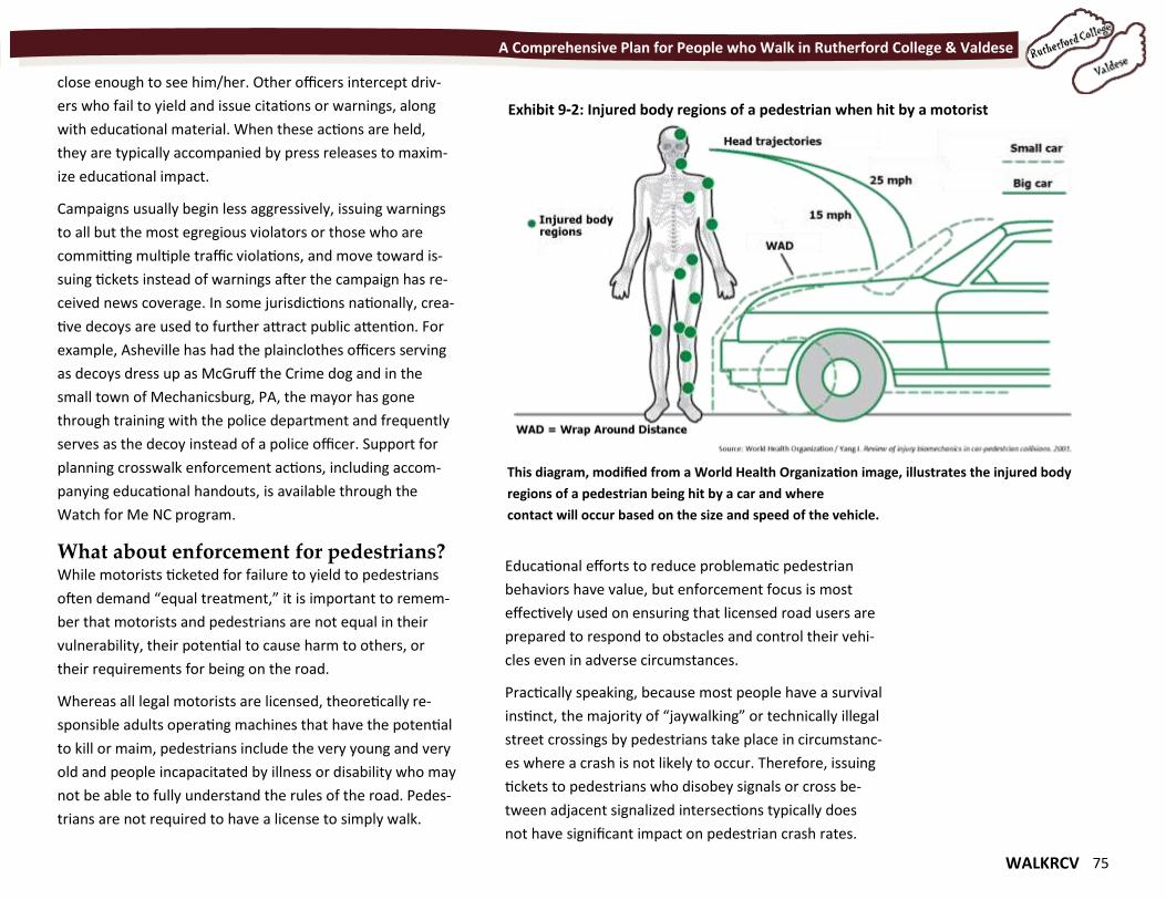
WALKRCV 75
A Comprehensive Plan for People who Walk in Rutherford College & Valdese
close enough to see him/her. Other officers intercept driv-
ers who fail to yield and issue citations or warnings, along
with educational material. When these actions are held,
they are typically accompanied by press releases to maxim-
ize educational impact.
Campaigns usually begin less aggressively, issuing warnings
to all but the most egregious violators or those who are
committing multiple traffic violations, and move toward is-
suing tickets instead of warnings after the campaign has re-
ceived news coverage. In some jurisdictions nationally, crea-
tive decoys are used to further attract public attention. For
example, Asheville has had the plainclothes officers serving
as decoys dress up as McGruff the Crime dog and in the
small town of Mechanicsburg, PA, the mayor has gone
through training with the police department and frequently
serves as the decoy instead of a police officer. Support for
planning crosswalk enforcement actions, including accom-
panying educational handouts, is available through the
Watch for Me NC program.
What about enforcement for pedestrians? While motorists ticketed for failure to yield to pedestrians
often demand “equal treatment,” it is important to remem-
ber that motorists and pedestrians are not equal in their
vulnerability, their potential to cause harm to others, or
their requirements for being on the road.
Whereas all legal motorists are licensed, theoretically re-
sponsible adults operating machines that have the potential
to kill or maim, pedestrians include the very young and very
old and people incapacitated by illness or disability who may
not be able to fully understand the rules of the road. Pedes-
trians are not required to have a license to simply walk.
Educational efforts to reduce problematic pedestrian
behaviors have value, but enforcement focus is most
effectively used on ensuring that licensed road users are
prepared to respond to obstacles and control their vehi-
cles even in adverse circumstances.
Practically speaking, because most people have a survival
instinct, the majority of “jaywalking” or technically illegal
street crossings by pedestrians take place in circumstanc-
es where a crash is not likely to occur. Therefore, issuing
tickets to pedestrians who disobey signals or cross be-
tween adjacent signalized intersections typically does
not have significant impact on pedestrian crash rates.
Exhibit 9-2: Injured body regions of a pedestrian when hit by a motorist
This diagram, modified from a World Health Organization image, illustrates the injured body
regions of a pedestrian being hit by a car and where
contact will occur based on the size and speed of the vehicle.

76 WALKRCV
A Comprehensive Plan for People who Walk in Rutherford College & Valdese
As documented by the DC area’s Street Smart Pedestri-
an and Bicycle Safety Enforcement Training Manual
(2007), they found that cities that conducted an aggres-
sive “jaywalking” enforcement campaign in the late
1900s found that it had no impact on the city’s rate of
pedestrian crashes. Upon this finding, they changed the
focus of their pedestrian safety programs and undertak-
ing other efforts to make the city more walkable.
Officers who witness dangerous pedestrian law viola-
tions can issue tickets, but a concentrated effort of forc-
ing pedestrians to wait for signals or go out of their way
to use crosswalks is of limited safety value, particularly if
drivers are not fully compliant with laws at crosswalks.
Education for Law Enforcement As pedestrian and bicyclist volumes increase across the
country, many jurisdictions are realizing that training of
law enforcement officers related to non-motorized road
users needs to be updated and augmented. Officers
must not only enforce the laws, but also set a positive
example for other drivers by complying with crosswalk
laws and operating their cruisers safely. Officer training
should include a refresher course on state laws relating
to pedestrians, including the definition of an unmarked
crosswalk and driver responsibilities at all crosswalks
and under what circumstances it is legal for a pedestrian
to cross at mid-block.
In areas with new pedestrian enforcement programs, it
is not uncommon for police to issue tickets to pedestri-
ans for crossing at mid-block even though the pedestri-
an was not between two adjacent signalized intersec-
tions, for example. Officers, along with other municipal
employees, can also benefit from education about the physi-
cal and mental health benefits of walking.
Enforcement & Safe Routes to School Often thought only as traffic violation ticketing, enforcement
is a communitywide effort and one of the key strategies of a
Safe Routes to Schools program. Students, parents, school
staff, police officers, members of the media, and other partic-
ipants are all important stakeholders that help ensure traffic
laws are obeyed and roads are safely shared. When properly
equipped, each group can spread awareness and hold mem-
bers of the school’s community accountable through a
unique contribution.
Such programs are not common in Rutherford College and
Valdese. Kids at Valdese Elementary School are discouraged
from walking and biking to school due to safety concerns.
Elements of this plan will help address those concerns and a
coordinated Safe Routes to School program would help alle-
viate common safety perceptions.
Bad driving behaviors around schools are discouraged
through targeted community enforcement, including:
Crossing guards for ingress/egress at school access points
and crosswalks during arrival and departure times.
Police conducting more speed enforcement in the school
zone & provide information to parents.
Schools developing special messaging for parents in the
form of flyers to handout during arrival and departure
time to remind them of the school zone and safe motor-
ing practices.
Offering small rewards for good and safe behaviors. In-
formation campaigns can be combined with a rewards
program to “catch” motorists behaving properly in the
school zone and at arrival/departure times.
School departure time can be
chaotic, which leads to actions
by motorists that can endanger
pedestrians. Schools can find
ways to frame enforcement
message in a positive light to
reward good behavior.
WALKRCV 77
"Walking is man’s best medicine." - Hippocrates
Chapter 10 The Wonder Drug Chapter 10 The Wonder Drug
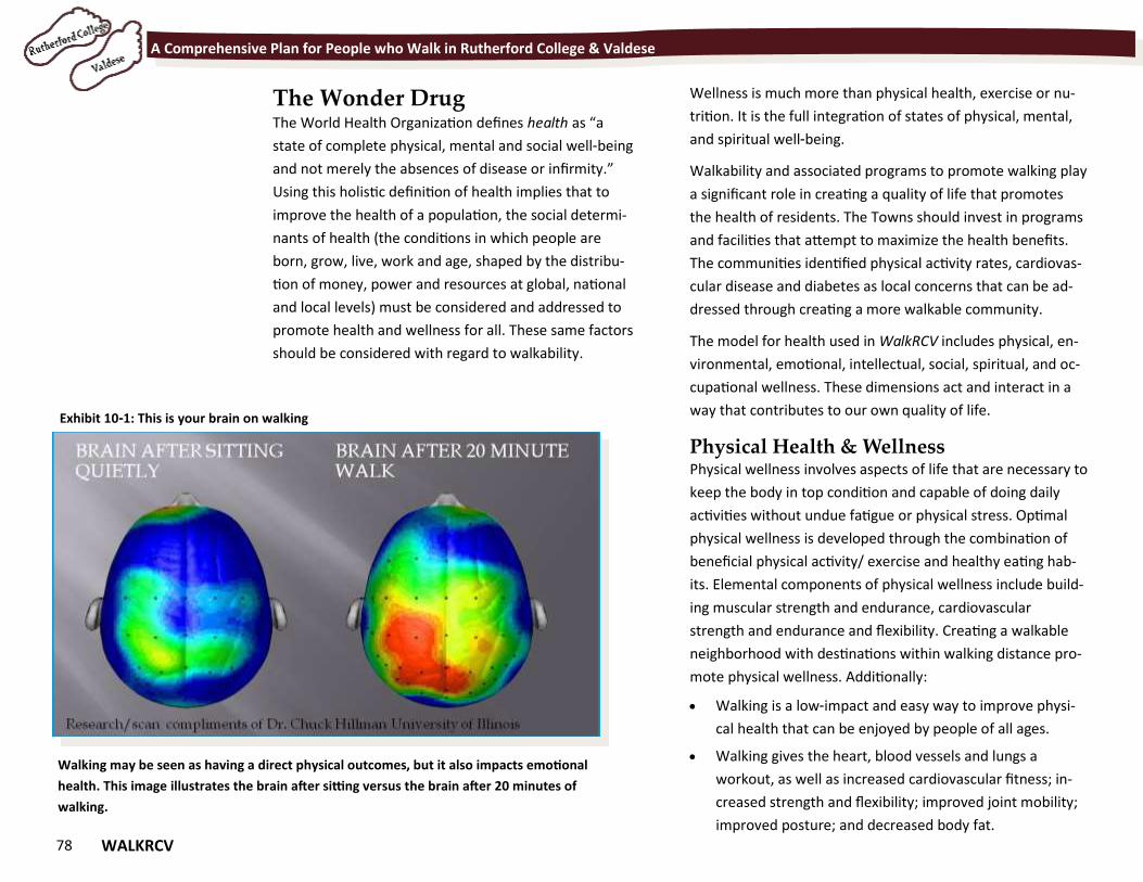
78 WALKRCV
A Comprehensive Plan for People who Walk in Rutherford College & Valdese
The Wonder Drug The World Health Organization defines health as “a
state of complete physical, mental and social well-being
and not merely the absences of disease or infirmity.”
Using this holistic definition of health implies that to
improve the health of a population, the social determi-
nants of health (the conditions in which people are
born, grow, live, work and age, shaped by the distribu-
tion of money, power and resources at global, national
and local levels) must be considered and addressed to
promote health and wellness for all. These same factors
should be considered with regard to walkability.
Wellness is much more than physical health, exercise or nu-
trition. It is the full integration of states of physical, mental,
and spiritual well-being.
Walkability and associated programs to promote walking play
a significant role in creating a quality of life that promotes
the health of residents. The Towns should invest in programs
and facilities that attempt to maximize the health benefits.
The communities identified physical activity rates, cardiovas-
cular disease and diabetes as local concerns that can be ad-
dressed through creating a more walkable community.
The model for health used in WalkRCV includes physical, en-
vironmental, emotional, intellectual, social, spiritual, and oc-
cupational wellness. These dimensions act and interact in a
way that contributes to our own quality of life.
Physical Health & Wellness Physical wellness involves aspects of life that are necessary to
keep the body in top condition and capable of doing daily
activities without undue fatigue or physical stress. Optimal
physical wellness is developed through the combination of
beneficial physical activity/ exercise and healthy eating hab-
its. Elemental components of physical wellness include build-
ing muscular strength and endurance, cardiovascular
strength and endurance and flexibility. Creating a walkable
neighborhood with destinations within walking distance pro-
mote physical wellness. Additionally:
Walking is a low-impact and easy way to improve physi-
cal health that can be enjoyed by people of all ages.
Walking gives the heart, blood vessels and lungs a
workout, as well as increased cardiovascular fitness; in-
creased strength and flexibility; improved joint mobility;
improved posture; and decreased body fat.
Walking may be seen as having a direct physical outcomes, but it also impacts emotional
health. This image illustrates the brain after sitting versus the brain after 20 minutes of
walking.
Exhibit 10-1: This is your brain on walking
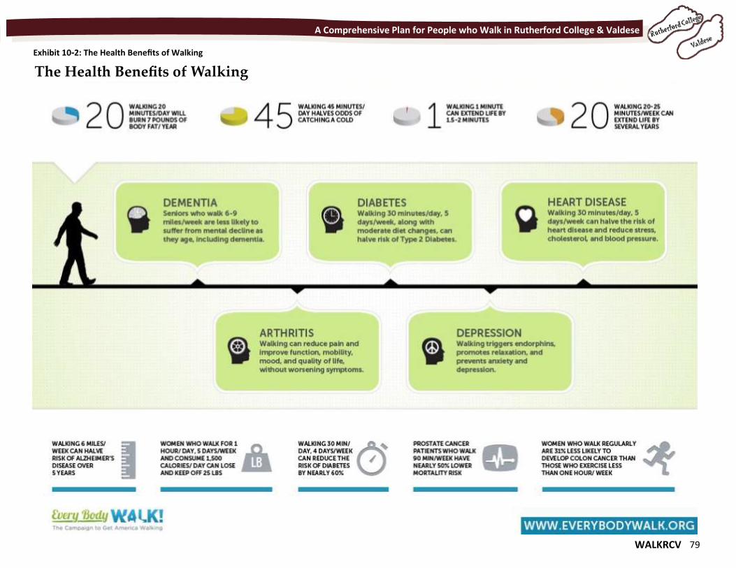
WALKRCV 79
A Comprehensive Plan for People who Walk in Rutherford College & Valdese
Exhibit 10-2: The Health Benefits of Walking
The Health Benefits of Walking
80 WALKRCV
A Comprehensive Plan for People who Walk in Rutherford College & Valdese
It is one of the best ways to reduce the risk of
health problems such as stroke, heart disease, some
cancers, diabetes and arthritis.
30 minutes of moderate walking per day five days a
week can help ensure a longer, healthier and happi-
er life.
One hour of walking may increase your life expec-
tancy by two hours.
Emotional Health & Wellness Emotional Wellness is the ability to under-
stand ourselves and cope with the chal-
lenges life can bring. The ability to
acknowledge and share feelings of anger,
fear, sadness or stress; hope, love, joy and
happiness in a productive manner contrib-
utes to our Emotional Wellness. It also
involves being attentive to your thoughts,
feelings, and behaviors, whether positive or negative.
Walking can improve our mood and help flush toxins
out of our body that can negatively effect our mental
health. The brain after just 20 minutes of walking is in-
vigorated and ready to respond to challenges.
Social Health & Wellness Social Wellness is the ability to relate to, interact with,
and connect with other people in our world. It involves
using good communication skills, having meaningful
relationships, respecting yourself and others, and cre-
ating a support system that includes family members
and friends.
Our ability to establish and maintain positive relation-
ships with family, friends, and co-workers contributes to
our Social Wellness. Walking can and should be a social en-
deavor. When given a quiet and safe place to walk, families
and friends can enjoy time together and explore a neighbor-
hood, share a meal or run errands together. Unlike vehicular
travel, walking can influence and motivate people to take
more care of the community.
Environmental Health & Wellness Environmental Wellness is the realization of our innate con-
nection to nature and our ability to recognize our own re-
sponsibility for the quality of the air, the water, and the land
that surrounds us. The ability to make a
positive impact on the quality of the envi-
ronment--be it our homes, our communi-
ties or our planet-- contributes to our Envi-
ronmental Wellness. Protecting yourself
from environmental hazards and minimiz-
ing the negative impact of your behavior on
the environment are also central elements.
If we ask that pedestrians walk in an area that is filled with
noise pollution or high traffic volumes, special accommoda-
tions should be made to mitigate the negative influences of
that environment.
Intellectual Health & Wellness Intellectual Wellness is the ability to open our minds to new
ideas and experiences that can be applied to personal deci-
sions, group interaction and community betterment. The de-
sire to learn new concepts, improve skills and seek challenges
in pursuit of lifelong learning contributes to our Intellectual
Wellness. Historic walking tours or designated routes can
help community member and visitors gain greater apprecia-
tion, in an active way. Safe walking areas can be enjoyed by
school classes, Sunday school classes and other types of in-
One hour of
walking may increase
your life expectancy
by two hours.
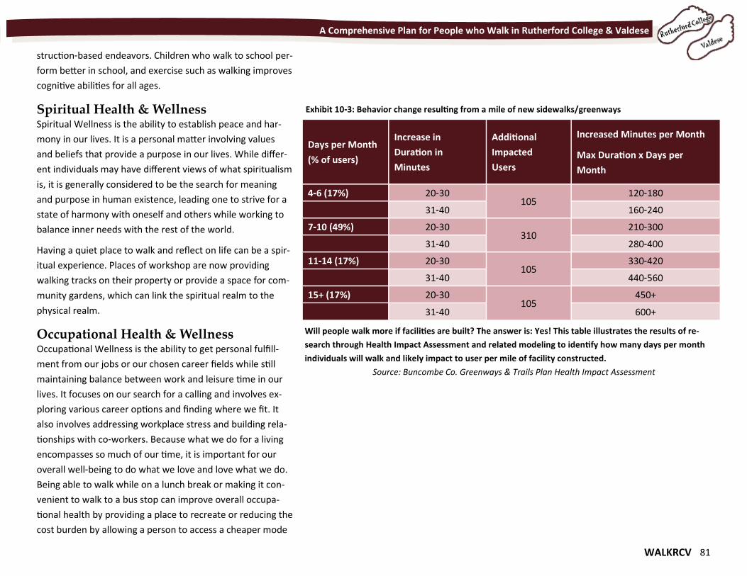
WALKRCV 81
A Comprehensive Plan for People who Walk in Rutherford College & Valdese
struction-based endeavors. Children who walk to school per-
form better in school, and exercise such as walking improves
cognitive abilities for all ages.
Spiritual Health & Wellness Spiritual Wellness is the ability to establish peace and har-
mony in our lives. It is a personal matter involving values
and beliefs that provide a purpose in our lives. While differ-
ent individuals may have different views of what spiritualism
is, it is generally considered to be the search for meaning
and purpose in human existence, leading one to strive for a
state of harmony with oneself and others while working to
balance inner needs with the rest of the world.
Having a quiet place to walk and reflect on life can be a spir-
itual experience. Places of workshop are now providing
walking tracks on their property or provide a space for com-
munity gardens, which can link the spiritual realm to the
physical realm.
Occupational Health & Wellness Occupational Wellness is the ability to get personal fulfill-
ment from our jobs or our chosen career fields while still
maintaining balance between work and leisure time in our
lives. It focuses on our search for a calling and involves ex-
ploring various career options and finding where we fit. It
also involves addressing workplace stress and building rela-
tionships with co-workers. Because what we do for a living
encompasses so much of our time, it is important for our
overall well-being to do what we love and love what we do.
Being able to walk while on a lunch break or making it con-
venient to walk to a bus stop can improve overall occupa-
tional health by providing a place to recreate or reducing the
cost burden by allowing a person to access a cheaper mode
Days per Month
(% of users)
Increase in
Duration in
Minutes
Additional
Impacted
Users
Increased Minutes per Month
Max Duration x Days per
Month
4-6 (17%) 20-30 105
120-180
31-40 160-240
7-10 (49%) 20-30 310
210-300
31-40 280-400
11-14 (17%) 20-30 105
330-420
31-40 440-560
15+ (17%) 20-30 105
450+
31-40 600+
Exhibit 10-3: Behavior change resulting from a mile of new sidewalks/greenways
Will people walk more if facilities are built? The answer is: Yes! This table illustrates the results of re-
search through Health Impact Assessment and related modeling to identify how many days per month
individuals will walk and likely impact to user per mile of facility constructed.
Source: Buncombe Co. Greenways & Trails Plan Health Impact Assessment
82 WALKRCV
A Comprehensive Plan for People who Walk in Rutherford College & Valdese
of transportation.
Health-based Investments The multi-criteria evaluation for pedestrian projects for
this plan included several categories that relate to im-
prove health conditions as a result of the project. These
factors were safety, proximity to parks, schools and em-
ployment, access to food and populations in need. In a
review of the recommended projects as well as prevail-
ing research related to health impacts and project eval-
uation criteria, the following projects appear to have
the most potential to positively impact the health of the
community (Exhibit 10-4):
Pathway Network: The planned pathway network,
once complete, provides the greatest potential posi-
tive impact for all 7 dimensions of health due to
proximity to nature and connections to the schools.
Main Street—Valdese: Up-
grading these crossings and
completing the sidewalk net-
work to the west encourages
walking for many purposes to
many destinations, and by peo-
ple of all ages and abilities.
Malcolm Boulevard—
Rutherford College: This route
is the spine of the town and
links neighborhoods, churches,
businesses, parks, the hospital
and the walking trail.
It is recommended that the
Towns engage health-based
organizations to seek funding for these high priority health
projects.
Health Impacts of Pedestrian Facility In-
vestments Exhibit 10-3 (previous page) outlines the likely impacts of
people’s behavior for each mile of sidewalk or greenway
constructed. Exhibit 10-5 indicates several types of pedestri-
an facility investments and the likely health impacts, both
positive and negative, of those investments. It is hard to find
negative impacts of investing in pedestrian facilities as many
have the potential, based on research by academics, health
professionals and transportation researchers, to greatly im-
pact a community’s health and an individual’s health in
many ways. Some of these positive impacts include:
Providing a place for people of all ages and abilities to
safely walk for transportation, recreation and socializing;
Connecting destinations by facilities that encourage
walking rather than driving, which saves money and in-
creases physical activity;
Eliminating the need for pedestrians to walk in the road-
way;
Places pedestrians in more predictable locations along
roadways; and
Provides a space that is more resilient to the impacts
flooding and other episodic hazards.
The negative health impacts that can arise with pedestrian
facility investment are primarily related to episodic inci-
dents, construction impacts and a mix of users (e.g. bicy-
clists). Incorrect placement of pedestrian facilities or poorly
“NCDOT may have opportunities to support
positive health outcomes by considering
public health implications in our decision-
making across all transportation modes,
programs, policies, projects, and services,
and through all stages of the life of a
transportation project from planning to
project development, construction,
operations, and maintenance. “ - NCDOT’s Transportation & Public
Health Policy, adopted 2012
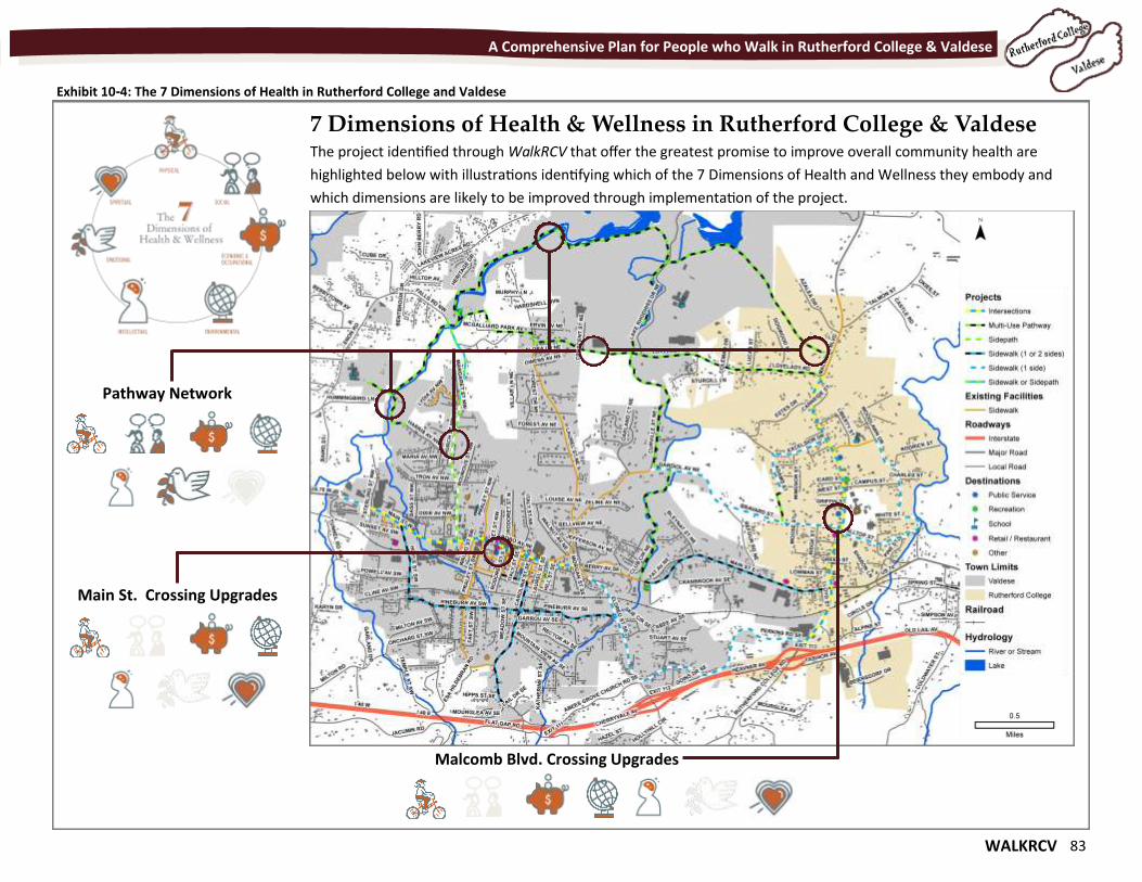
WALKRCV 83
A Comprehensive Plan for People who Walk in Rutherford College & Valdese
Exhibit 10-4: The 7 Dimensions of Health in Rutherford College and Valdese
Main St. Crossing Upgrades
7 Dimensions of Health & Wellness in Rutherford College & Valdese The project identified through WalkRCV that offer the greatest promise to improve overall community health are
highlighted below with illustrations identifying which of the 7 Dimensions of Health and Wellness they embody and
which dimensions are likely to be improved through implementation of the project.
Pathway Network
Malcomb Blvd. Crossing Upgrades
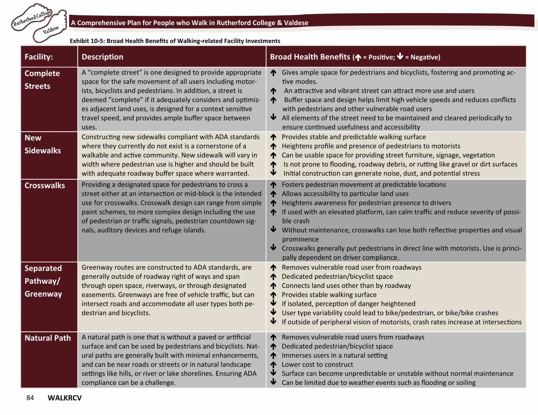
84 WALKRCV
A Comprehensive Plan for People who Walk in Rutherford College & Valdese
Facility: Description Broad Health Benefits ( = Positive; = Negative)
Complete
Streets
A “complete street” is one designed to provide appropriate space for the safe movement of all users including motor-ists, bicyclists and pedestrians. In addition, a street is deemed “complete” if it adequately considers and optimiz-es adjacent land uses, is designed for a context sensitive travel speed, and provides ample buffer space between uses.
Gives ample space for pedestrians and bicyclists, fostering and promoting ac-tive modes.
An attractive and vibrant street can attract more use and users Buffer space and design helps limit high vehicle speeds and reduces conflicts
with pedestrians and other vulnerable road users All elements of the street need to be maintained and cleared periodically to
ensure continued usefulness and accessibility
New
Sidewalks
Constructing new sidewalks compliant with ADA standards where they currently do not exist is a cornerstone of a walkable and active community. New sidewalk will vary in width where pedestrian use is higher and should be built with adequate roadway buffer space where warranted.
Provides stable and predictable walking surface Heightens profile and presence of pedestrians to motorists Can be usable space for providing street furniture, signage, vegetation Is not prone to flooding, roadway debris, or rutting like gravel or dirt surfaces Initial construction can generate noise, dust, and potential stress
Crosswalks Providing a designated space for pedestrians to cross a street either at an intersection or mid-block is the intended use for crosswalks. Crosswalk design can range from simple paint schemes, to more complex design including the use of pedestrian or traffic signals, pedestrian countdown sig-nals, auditory devices and refuge islands.
Fosters pedestrian movement at predictable locations Allows accessibility to particular land uses Heightens awareness for pedestrian presence to drivers If used with an elevated platform, can calm traffic and reduce severity of possi-
ble crash Without maintenance, crosswalks can lose both reflective properties and visual
prominence Crosswalks generally put pedestrians in direct line with motorists. Use is princi-
pally dependent on driver compliance.
Separated
Pathway/
Greenway
Greenway routes are constructed to ADA standards, are generally outside of roadway right of ways and span through open space, riverways, or through designated easements. Greenways are free of vehicle traffic, but can intersect roads and accommodate all user types both pe-destrian and bicyclists.
Removes vulnerable road user from roadways Dedicated pedestrian/bicyclist space Connects land uses other than by roadway Provides stable walking surface If isolated, perception of danger heightened User type variability could lead to bike/pedestrian, or bike/bike crashes If outside of peripheral vision of motorists, crash rates increase at intersections
Natural Path A natural path is one that is without a paved or artificial surface and can be used by pedestrians and bicyclists. Nat-ural paths are generally built with minimal enhancements, and can be near roads or streets or in natural landscape settings like hills, or river or lake shorelines. Ensuring ADA compliance can be a challenge.
Removes vulnerable road users from roadways Dedicated pedestrian/bicyclist space Immerses users in a natural setting Lower cost to construct Surface can become unpredictable or unstable without normal maintenance Can be limited due to weather events such as flooding or soiling
Exhibit 10-5: Broad Health Benefits of Walking-related Facility Investments
WALKRCV 85
"By doing things at the right time and in the right way, comprehensive planning saves far more than it costs." - John Nolen, New Towns for Old
Chapter 11 Implement & Evaluate Chapter 11 Implement & Evaluate
86 WALKRCV
A Comprehensive Plan for People who Walk in Rutherford College & Valdese
Implement & Evaluate Completion of WalkRCV is one step in creating a commu-
nity that is accommodating to people who walk. The im-
plementation of the Plan requires a coordinated effort
amongst officials of the two towns, leaders, and citizen
volunteers. Follow-up plans and studies,
particularly for greenways, are required
for more specific improvements.
This chapter identifies action steps for
moving forward with the recommenda-
tions of the Plan, as well as potential
funding sources and partners for pro-
posed projects.
The implementation strategies of
WalkRCV are closely aligned with areas
the state of North Carolina identified for
Bicycle and Pedestrian Safety Strategies
through a series of summits in early 2011
and through NCDOT’s Complete Streets
efforts.
The major action initiatives identified through those
summits to help guide NCDOT and other state agencies
through the next decade were:
Fully implement Complete Streets;
Address multi-modal funding;
Retrofit existing facilities;
Require more from all road users;
Increase public awareness through education;
Connect transportation and land use; and
Improve law and strengthen enforcement.
Each of these themes are addressed to some degree within
the Plan. This can help stakeholders within Rutherford Col-
lege, Valdese, Burke County and the greater Unifour Region
articulate to local, regional and state leaders that the imple-
mentation of this Plan is consistent with what has been iden-
tified at the state level.
These actions also help support the vision and goals of
NCDOT as well as making a case to the state and its leaders
that pedestrian needs are important. It will take the energy
of the communities and many stakeholders, as well as many
advocates, for walking and bicycling to once again become a
priority for North Carolina.
10 Action Steps for Implementation Completing the 10 Action Steps (Exhibit 11-1) on the next two
pages helps guide development of the proposed walking net-
work and creates a supportive program and policy environ-
ment for a walk-friendly Rutherford College and Valdese.
These steps will be crucial in moving forward with the overall
recommendations of the Pedestrian Plan.
The 10 Action Steps for Implementation are intended to
serve as a barometer for short-term accomplishments related
to this plan. The Towns should review these steps each year
to determine the best approach to achieving them.
State and federal policies related to transportation funding
and design have been in flux in recent year. It is important for
the Towns to work through Western Piedmont Council of
Governments to track these changes as they could greatly
influence funding opportunities. The next round of requests
to WPCOG for funding is in summer 2016 through the MPO’s
Direct Allocation source (STP-DA). The NCDOT request period
(SPOT) will likely re-open in mid-2017.
Participants at the December 2015 Open House
gave feedback on Action Steps for
Implementation. There was widespread support
for the pathway system near Lake Rhodhiss and
the connecting Lovelady Road Pathway.
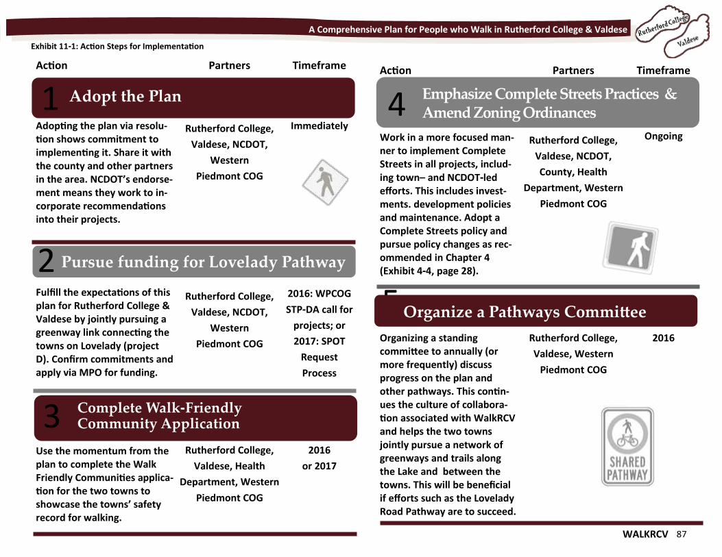
WALKRCV 87
A Comprehensive Plan for People who Walk in Rutherford College & Valdese
Adopt the Plan
Pursue funding for Lovelady Pathway
1
2
Action Partners Timeframe
Adopting the plan via resolu-tion shows commitment to implementing it. Share it with the county and other partners in the area. NCDOT’s endorse-ment means they work to in-corporate recommendations into their projects.
Rutherford College,
Valdese, NCDOT,
Western
Piedmont COG
Immediately
Fulfill the expectations of this plan for Rutherford College & Valdese by jointly pursuing a greenway link connecting the towns on Lovelady (project D). Confirm commitments and apply via MPO for funding.
Rutherford College,
Valdese, NCDOT,
Western
Piedmont COG
2016: WPCOG
STP-DA call for
projects; or
2017: SPOT
Request
Process
\
Use the momentum from the plan to complete the Walk Friendly Communities applica-tion for the two towns to showcase the towns’ safety record for walking.
Rutherford College,
Valdese, Health
Department, Western
Piedmont COG
2016
or 2017
Complete Walk-Friendly Community Application 3
Action Partners Timeframe
Work in a more focused man-ner to implement Complete Streets in all projects, includ-ing town– and NCDOT-led efforts. This includes invest-ments. development policies and maintenance. Adopt a Complete Streets policy and pursue policy changes as rec-ommended in Chapter 4 (Exhibit 4-4, page 28).
Rutherford College,
Valdese, NCDOT,
County, Health
Department, Western
Piedmont COG
Ongoing
Organizing a standing committee to annually (or more frequently) discuss progress on the plan and other pathways. This contin-ues the culture of collabora-tion associated with WalkRCV and helps the two towns jointly pursue a network of greenways and trails along the Lake and between the towns. This will be beneficial if efforts such as the Lovelady Road Pathway are to succeed.
Rutherford College,
Valdese, Western
Piedmont COG
2016
Emphasize Complete Streets Practices & Amend Zoning Ordinances 4
5 Organize a Pathways Committee
Exhibit 11-1: Action Steps for Implementation
88 WALKRCV
A Comprehensive Plan for People who Walk in Rutherford College & Valdese
Develop Supportive Education & Enforcement Programs
Evaluate 20 mph Residential Speed Limit
6
7
Engage Youth/Seniors to Raise Awareness
Action Partners Timeframe
Complement investment in sidewalks and greenways with safety and other campaigns to promote safe and increased use. These could include walking clubs, Safe Routes to School out-reach, and Watch for Me NC.
Rutherford College,
Valdese, NCDOT,
Western
Piedmont COG,
Schools, Health
Department
1-3 years
Streets without sidewalks require people to walk in the street, which is common on residential streets. Speed lim-its should maximize safety for pedestrians. A crash at 20 mph reduces the likelihood of a pedestrian death to 10%
Rutherford College,
Valdese, NCDOT,
Police Departments
1-3 years
\
Youth and senior populations are the most vulnerable pe-destrians who use the system. The Education, Encourage-ment and Engineering sec-tions address methods to make it safer for them.
Rutherford College,
Valdese, Health
Department, Schools,
County
As projects are
designed &
programs
implemented
8
Incorporate Walkability into Economic Development & Health Messaging
Measure Performance
9
10
Action Partners Timeframe
Brochures, strategies and plans for economic develop-ment and health should in-clude messages about the need for increased walkabil-ity. Surveys of businesses and residents should include ques-tions on walking.
Rutherford College,
Valdese, Health
Department,
Economic
Development
Ongoing
Conduct surveys on sidewalks and greenways, count users along popular routes, and track participation in Safe Routes to School. See details in Exhibit 11-2.
Rutherford College,
Valdese, Active
Routes to School,
Western Piedmont
COG
Beginning
in 2017
Exhibit 11-1, continued: Action Steps for Implementation
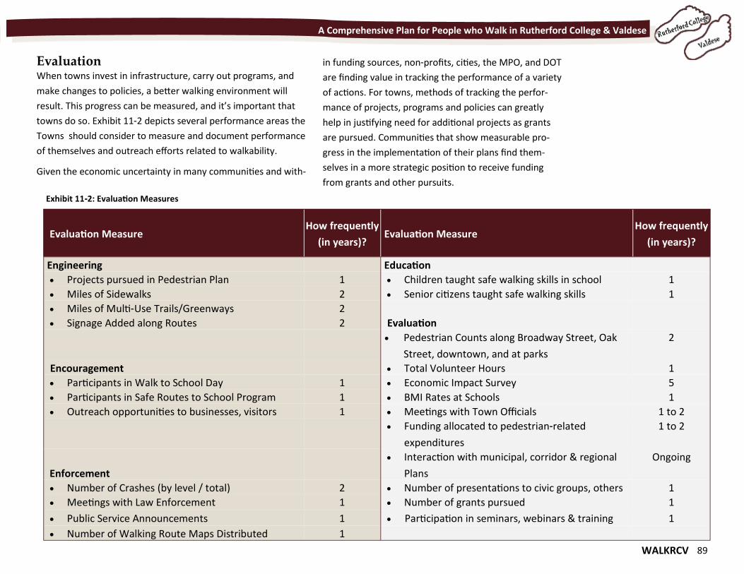
WALKRCV 89
A Comprehensive Plan for People who Walk in Rutherford College & Valdese
Evaluation When towns invest in infrastructure, carry out programs, and
make changes to policies, a better walking environment will
result. This progress can be measured, and it’s important that
towns do so. Exhibit 11-2 depicts several performance areas the
Towns should consider to measure and document performance
of themselves and outreach efforts related to walkability.
Given the economic uncertainty in many communities and with-
in funding sources, non-profits, cities, the MPO, and DOT
are finding value in tracking the performance of a variety
of actions. For towns, methods of tracking the perfor-
mance of projects, programs and policies can greatly
help in justifying need for additional projects as grants
are pursued. Communities that show measurable pro-
gress in the implementation of their plans find them-
selves in a more strategic position to receive funding
from grants and other pursuits.
Evaluation Measure How frequently
(in years)? Evaluation Measure
How frequently
(in years)?
Engineering Education
Projects pursued in Pedestrian Plan 1 Children taught safe walking skills in school 1
Miles of Sidewalks 2 Senior citizens taught safe walking skills 1
Miles of Multi-Use Trails/Greenways 2
Signage Added along Routes 2 Evaluation
Pedestrian Counts along Broadway Street, Oak
Street, downtown, and at parks
2
Encouragement Total Volunteer Hours 1
Participants in Walk to School Day 1 Economic Impact Survey 5
Participants in Safe Routes to School Program 1 BMI Rates at Schools 1
Outreach opportunities to businesses, visitors 1 Meetings with Town Officials 1 to 2
Funding allocated to pedestrian-related
expenditures
1 to 2
Enforcement
Interaction with municipal, corridor & regional
Plans
Ongoing
Number of Crashes (by level / total) 2 Number of presentations to civic groups, others 1
Meetings with Law Enforcement 1 Number of grants pursued 1
Public Service Announcements 1 Participation in seminars, webinars & training 1
Number of Walking Route Maps Distributed 1
Exhibit 11-2: Evaluation Measures
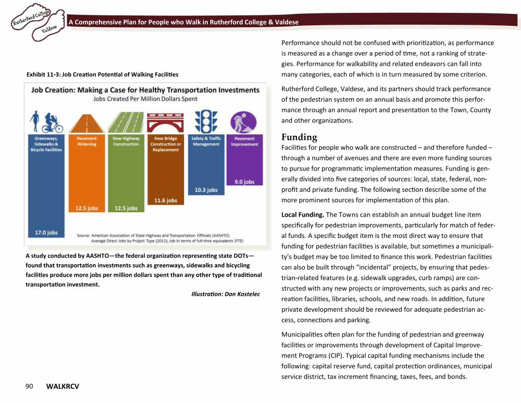
90 WALKRCV
A Comprehensive Plan for People who Walk in Rutherford College & Valdese
Performance should not be confused with prioritization, as performance
is measured as a change over a period of time, not a ranking of strate-
gies. Performance for walkability and related endeavors can fall into
many categories, each of which is in turn measured by some criterion.
Rutherford College, Valdese, and its partners should track performance
of the pedestrian system on an annual basis and promote this perfor-
mance through an annual report and presentation to the Town, County
and other organizations.
Funding Facilities for people who walk are constructed – and therefore funded –
through a number of avenues and there are even more funding sources
to pursue for programmatic implementation measures. Funding is gen-
erally divided into five categories of sources: local, state, federal, non-
profit and private funding. The following section describe some of the
more prominent sources for implementation of this plan.
Local Funding. The Towns can establish an annual budget line item
specifically for pedestrian improvements, particularly for match of feder-
al funds. A specific budget item is the most direct way to ensure that
funding for pedestrian facilities is available, but sometimes a municipali-
ty’s budget may be too limited to finance this work. Pedestrian facilities
can also be built through “incidental” projects, by ensuring that pedes-
trian-related features (e.g. sidewalk upgrades, curb ramps) are con-
structed with any new projects or improvements, such as parks and rec-
reation facilities, libraries, schools, and new roads. In addition, future
private development should be reviewed for adequate pedestrian ac-
cess, connections and parking.
Municipalities often plan for the funding of pedestrian and greenway
facilities or improvements through development of Capital Improve-
ment Programs (CIP). Typical capital funding mechanisms include the
following: capital reserve fund, capital protection ordinances, municipal
service district, tax increment financing, taxes, fees, and bonds.
A study conducted by AASHTO—the federal organization representing state DOTs—
found that transportation investments such as greenways, sidewalks and bicycling
facilities produce more jobs per million dollars spent than any other type of traditional
transportation investment.
Illustration: Don Kostelec
Exhibit 11-3: Job Creation Potential of Walking Facilities
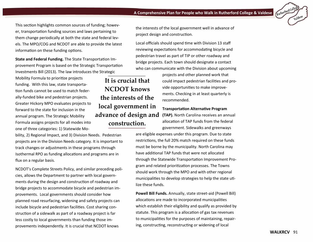
WALKRCV 91
A Comprehensive Plan for People who Walk in Rutherford College & Valdese
This section highlights common sources of funding; howev-
er, transportation funding sources and laws pertaining to
them change periodically at both the state and federal lev-
els. The MPO/COG and NCDOT are able to provide the latest
information on these funding options.
State and Federal Funding. The State Transportation Im-
provement Program is based on the Strategic Transportation
Investments Bill (2013). The law introduces the Strategic
Mobility Formula to prioritize projects
funding. With this law, state transporta-
tion funds cannot be used to match feder-
ally-funded bike and pedestrian projects.
Greater Hickory MPO evaluates projects to
forward to the state for inclusion in the
annual program. The Strategic Mobility
Formula assigns projects for all modes into
one of three categories: 1) Statewide Mo-
bility, 2) Regional Impact, and 3) Division Needs. Pedestrian
projects are in the Division Needs category. It is important to
track changes or adjustments in these programs through
Isothermal RPO as funding allocations and programs are in
flux on a regular basis.
NCDOT’s Complete Streets Policy, and similar preceding poli-
cies, allows the Department to partner with local govern-
ments during the design and construction of roadway and
bridge projects to accommodate bicycle and pedestrian im-
provements. Local governments should consider how
planned road resurfacing, widening and safety projects can
include bicycle and pedestrian facilities. Cost sharing con-
struction of a sidewalk as part of a roadway project is far
less costly to local governments than funding those im-
provements independently. It is crucial that NCDOT knows
the interests of the local government well in advance of
project design and construction.
Local officials should spend time with Division 13 staff
reviewing expectations for accommodating bicycle and
pedestrian travel as part of TIP or other roadway and
bridge projects. Each town should designate a contact
who can communicate with the Division about upcoming
projects and other planned work that
could impact pedestrian facilities and pro-
vide opportunities to make improve-
ments. Checking in at least quarterly is
recommended.
Transportation Alternative Program
(TAP). North Carolina receives an annual
allocation of TAP funds from the federal
government. Sidewalks and greenways
are eligible expenses under this program. Due to state
restrictions, the full 20% match required on these funds
must be borne by the municipality. North Carolina may
have additional TAP funds that were not allocated
through the Statewide Transportation Improvement Pro-
gram and related prioritization processes. The Towns
should work through the MPO and with other regional
municipalities to develop strategies to help the state uti-
lize these funds.
Powell Bill Funds. Annually, state street-aid (Powell Bill)
allocations are made to incorporated municipalities
which establish their eligibility and qualify as provided by
statute. This program is a allocation of gas tax revenues
to municipalities for the purposes of maintaining, repair-
ing, constructing, reconstructing or widening of local
It is crucial that
NCDOT knows
the interests of the
local government in
advance of design and
construction.
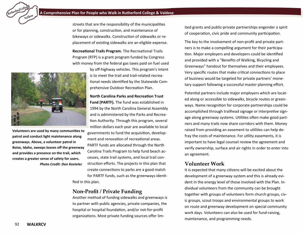
92 WALKRCV
A Comprehensive Plan for People who Walk in Rutherford College & Valdese
streets that are the responsibility of the municipalities
or for planning, construction, and maintenance of
bikeways or sidewalks. Construction of sidewalks or re-
placement of existing sidewalks are an eligible expense.
Recreational Trails Program. The Recreational Trails
Program (RTP) is a grant program funded by Congress
with money from the federal gas taxes paid on fuel used
by off-highway vehicles. This program's intent
is to meet the trail and trail-related recrea-
tional needs identified by the Statewide Com-
prehensive Outdoor Recreation Plan.
North Carolina Parks and Recreation Trust
Fund (PARTF). The fund was established in
1994 by the North Carolina General Assembly
and is administered by the Parks and Recrea-
tion Authority. Through this program, several
million dollars each year are available to local
governments to fund the acquisition, develop-
ment and renovation of recreational areas.
PARTF funds are allocated through the North
Carolina Trails Program to help fund beach ac-
cesses, state trail systems, and local trail con-
struction efforts. The projects in this plan that
create connections to parks are a good match
for PARTF funds, such as the greenways identi-
fied in this plan.
Non-Profit / Private Funding Another method of funding sidewalks and greenways is
to partner with public agencies, private companies, the
hospital or hospital foundation, and/or not-for-profit
organizations. Most private funding sources offer lim-
Volunteers are used by many communities to
patrol and conduct light maintenance along
greenways. Above, a volunteer patrol in
Boise, Idaho, sweeps leaves off the greenway
and provides a presence on the trail, which
creates a greater sense of safety for users.
Photo Credit: Don Kostelec
ited grants and public-private partnerships engender a spirit
of cooperation, civic pride and community participation.
The key to the involvement of non-profit and private part-
ners is to make a compelling argument for their participa-
tion. Major employers and developers could be identified
and provided with a “Benefits of Walking, Bicycling and
Greenways” handout for themselves and their employees.
Very specific routes that make critical connections to place
of business would be targeted for private partners’ mone-
tary support following a successful master planning effort.
Potential partners include major employers which are locat-
ed along or accessible to sidewalks, bicycle routes or green-
ways. Name recognition for corporate partnerships could be
accomplished through trailhead signage or interpretive sign-
age along greenway systems. Utilities often make good part-
ners and many trails now share corridors with them. Money
raised from providing an easement to utilities can help de-
fray the costs of maintenance. For utility easements, it is
important to have legal counsel review the agreement and
verify ownership, surface and air rights in order to enter into
an agreement.
Volunteer Work It is expected that many citizens will be excited about the
development of a greenway system and this is already evi-
dent in the energy level of those involved with the Plan. In-
dividual volunteers from the community can be brought
together with groups of volunteers form church groups, civ-
ic groups, scout troops and environmental groups to work
on route and greenway development on special community
work days. Volunteers can also be used for fund-raising,
maintenance, and programming needs.
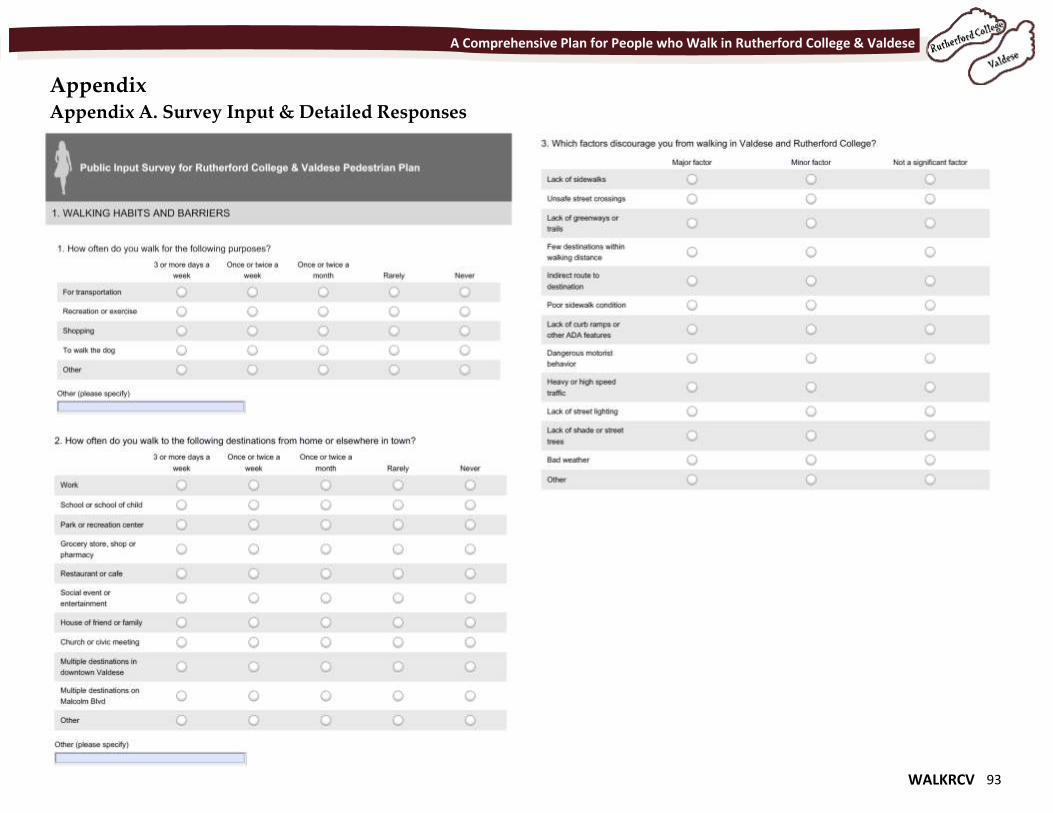
WALKRCV 93
A Comprehensive Plan for People who Walk in Rutherford College & Valdese
Appendix Appendix A. Survey Input & Detailed Responses
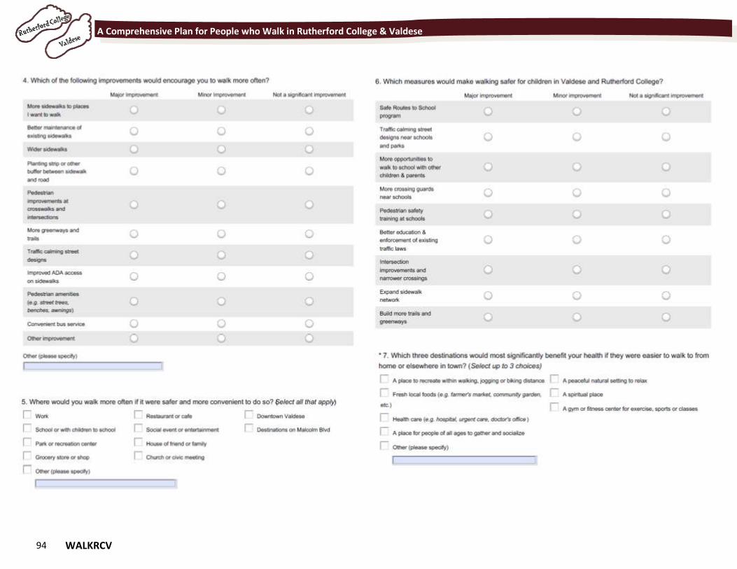
94 WALKRCV
A Comprehensive Plan for People who Walk in Rutherford College & Valdese
WALKRCV 95
A Comprehensive Plan for People who Walk in Rutherford College & Valdese
96 WALKRCV
A Comprehensive Plan for People who Walk in Rutherford College & Valdese
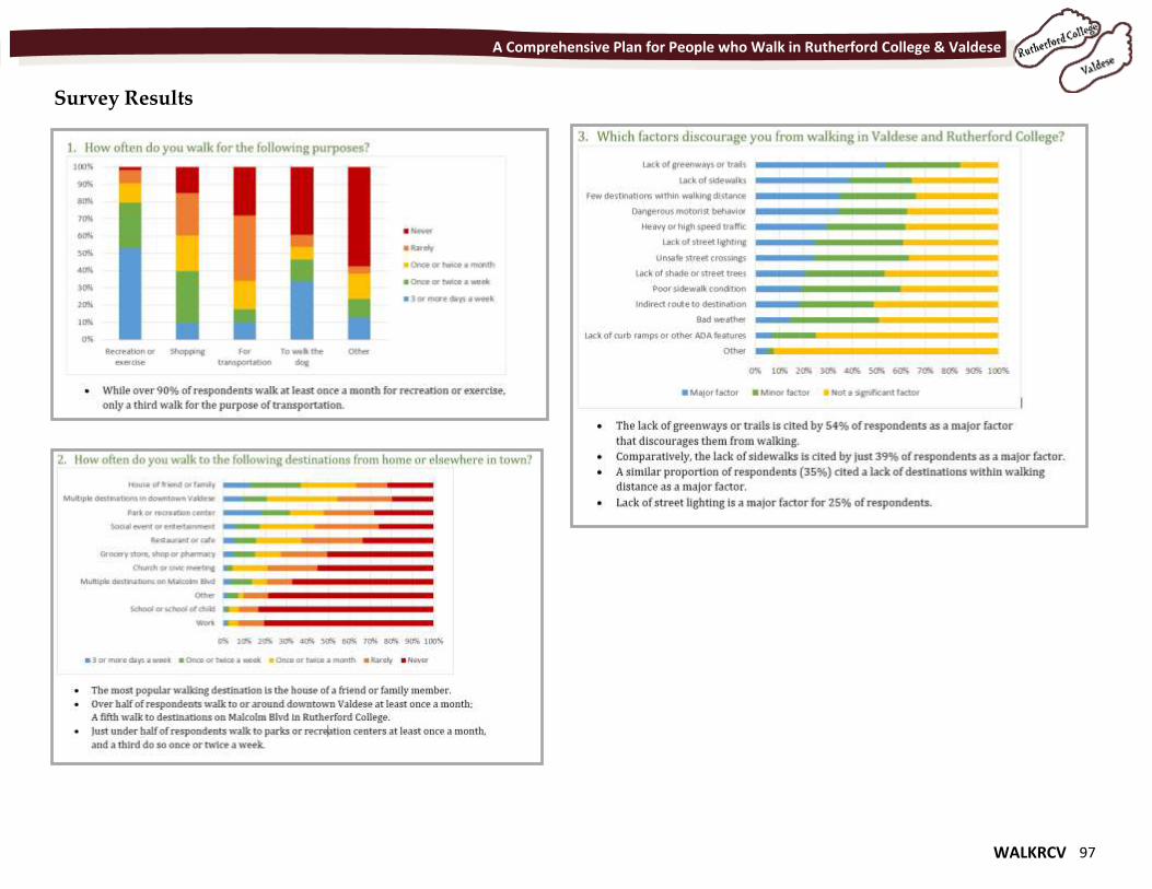
WALKRCV 97
A Comprehensive Plan for People who Walk in Rutherford College & Valdese
Survey Results
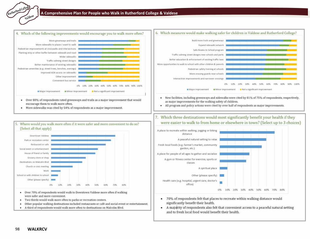
98 WALKRCV
A Comprehensive Plan for People who Walk in Rutherford College & Valdese
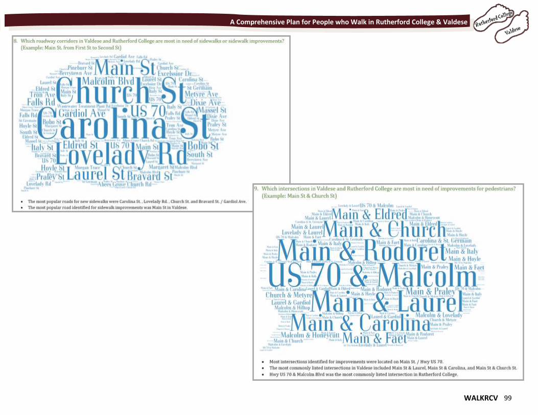
WALKRCV 99
A Comprehensive Plan for People who Walk in Rutherford College & Valdese
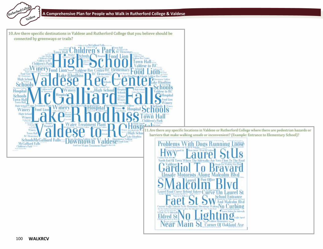
100 WALKRCV
A Comprehensive Plan for People who Walk in Rutherford College & Valdese
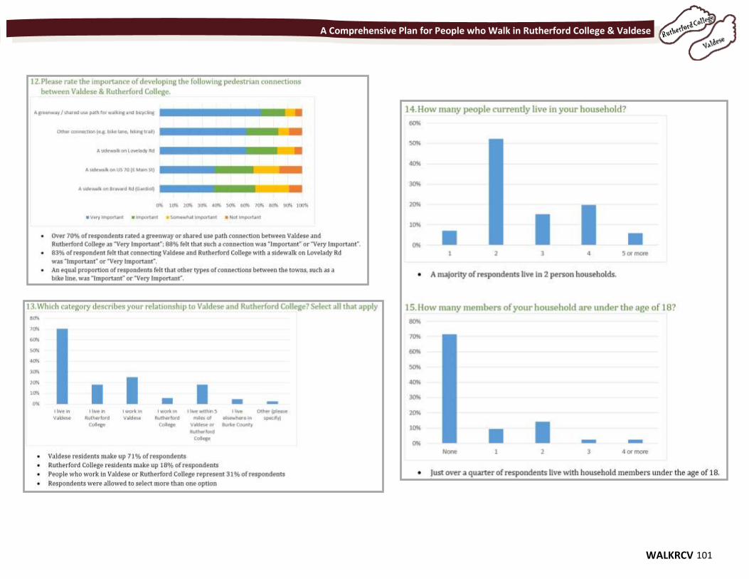
WALKRCV 101
A Comprehensive Plan for People who Walk in Rutherford College & Valdese
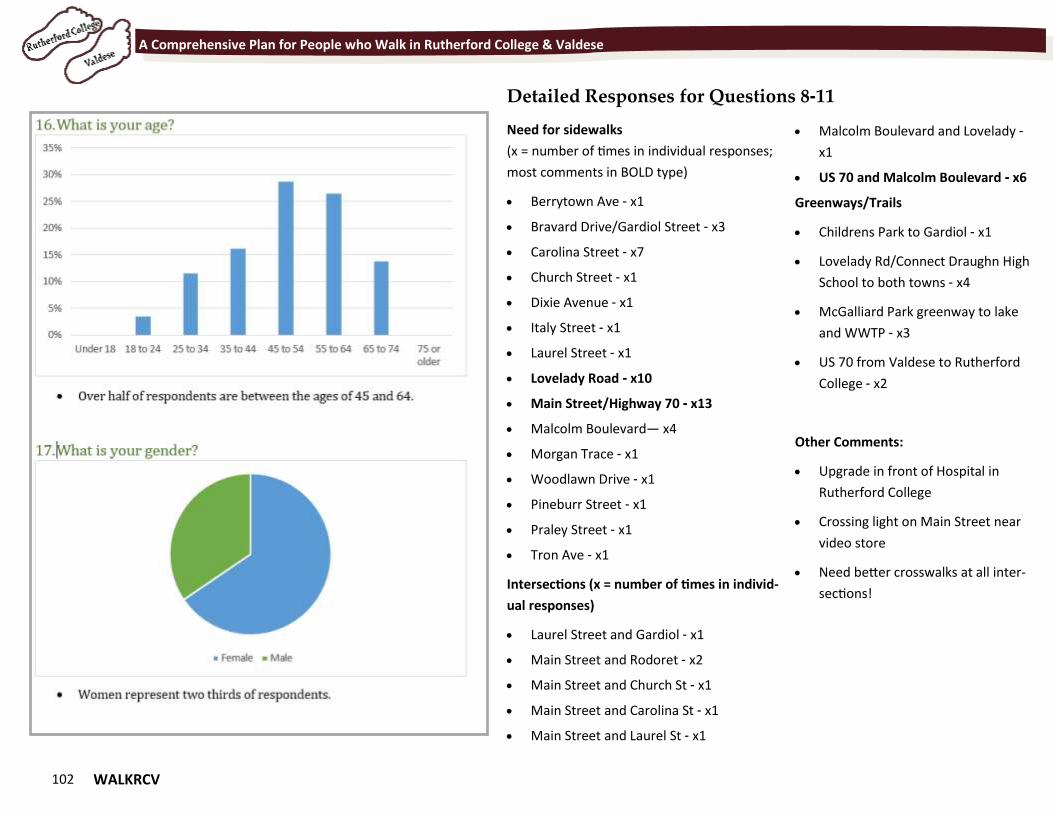
102 WALKRCV
A Comprehensive Plan for People who Walk in Rutherford College & Valdese
Need for sidewalks
(x = number of times in individual responses;
most comments in BOLD type)
Berrytown Ave - x1
Bravard Drive/Gardiol Street - x3
Carolina Street - x7
Church Street - x1
Dixie Avenue - x1
Italy Street - x1
Laurel Street - x1
Lovelady Road - x10
Main Street/Highway 70 - x13
Malcolm Boulevard— x4
Morgan Trace - x1
Woodlawn Drive - x1
Pineburr Street - x1
Praley Street - x1
Tron Ave - x1
Intersections (x = number of times in individ-
ual responses)
Laurel Street and Gardiol - x1
Main Street and Rodoret - x2
Main Street and Church St - x1
Main Street and Carolina St - x1
Main Street and Laurel St - x1
Malcolm Boulevard and Lovelady -
x1
US 70 and Malcolm Boulevard - x6
Greenways/Trails
Childrens Park to Gardiol - x1
Lovelady Rd/Connect Draughn High
School to both towns - x4
McGalliard Park greenway to lake
and WWTP - x3
US 70 from Valdese to Rutherford
College - x2
Other Comments:
Upgrade in front of Hospital in
Rutherford College
Crossing light on Main Street near
video store
Need better crosswalks at all inter-
sections!
Detailed Responses for Questions 8-11
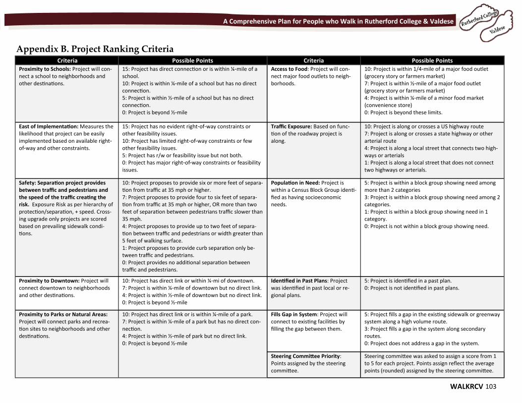
WALKRCV 103
A Comprehensive Plan for People who Walk in Rutherford College & Valdese
Appendix B. Project Ranking Criteria Criteria Possible Points Criteria Possible Points
Proximity to Schools: Project will con-nect a school to neighborhoods and other destinations.
15: Project has direct connection or is within ¼-mile of a school. 10: Project is within ¼-mile of a school but has no direct connection. 5: Project is within ½-mile of a school but has no direct connection. 0: Project is beyond ½-mile
Access to Food: Project will con-nect major food outlets to neigh-borhoods.
10: Project is within 1/4-mile of a major food outlet (grocery story or farmers market) 7: Project is within ½-mile of a major food outlet (grocery story or farmers market) 4: Project is within ¼-mile of a minor food market (convenience store) 0: Project is beyond these limits.
East of Implementation: Measures the likelihood that project can be easily implemented based on available right-of-way and other constraints.
15: Project has no evident right-of-way constraints or other feasibility issues. 10: Project has limited right-of-way constraints or few other feasibility issues. 5: Project has r/w or feasibility issue but not both. 0: Project has major right-of-way constraints or feasibility issues.
Traffic Exposure: Based on func-tion of the roadway project is along.
10: Project is along or crosses a US highway route 7: Project is along or crosses a state highway or other arterial route 4: Project is along a local street that connects two high-ways or arterials 1: Project is along a local street that does not connect two highways or arterials.
Safety: Separation project provides between traffic and pedestrians and the speed of the traffic creating the risk. Exposure Risk as per hierarchy of protection/separation, + speed. Cross-ing upgrade only projects are scored based on prevailing sidewalk condi-tions.
10: Project proposes to provide six or more feet of separa-tion from traffic at 35 mph or higher. 7: Project proposes to provide four to six feet of separa-tion from traffic at 35 mph or higher, OR more than two feet of separation between pedestrians traffic slower than 35 mph. 4: Project proposes to provide up to two feet of separa-tion between traffic and pedestrians or width greater than 5 feet of walking surface. 1: Project proposes to provide curb separation only be-tween traffic and pedestrians. 0: Project provides no additional separation between traffic and pedestrians.
Population in Need: Project is within a Census Block Group identi-fied as having socioeconomic needs.
5: Project is within a block group showing need among more than 2 categories 3: Project is within a block group showing need among 2 categories. 1: Project is within a block group showing need in 1 category. 0: Project is not within a block group showing need.
Proximity to Downtown: Project will connect downtown to neighborhoods and other destinations.
10: Project has direct link or within ¼-mi of downtown. 7: Project is within ¼-mile of downtown but no direct link. 4: Project is within ½-mile of downtown but no direct link. 0: Project is beyond ½-mile
Identified in Past Plans: Project was identified in past local or re-gional plans.
5: Project is identified in a past plan. 0: Project is not identified in past plans.
Proximity to Parks or Natural Areas: Project will connect parks and recrea-tion sites to neighborhoods and other destinations.
Fills Gap in System: Project will connect to existing facilities by filling the gap between them.
5: Project fills a gap in the existing sidewalk or greenway system along a high volume route. 3: Project fills a gap in the system along secondary routes. 0: Project does not address a gap in the system.
10: Project has direct link or is within ¼-mile of a park. 7: Project is within ¼-mile of a park but has no direct con-nection. 4: Project is within ½-mile of park but no direct link. 0: Project is beyond ½-mile
Steering Committee Priority: Points assigned by the steering committee.
Steering committee was asked to assign a score from 1 to 5 for each project. Points assign reflect the average points (rounded) assigned by the steering committee.
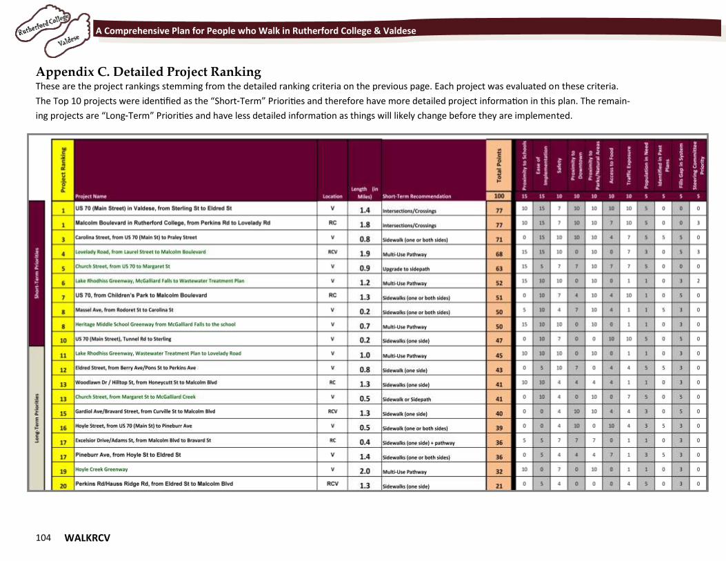
104 WALKRCV
A Comprehensive Plan for People who Walk in Rutherford College & Valdese
Appendix C. Detailed Project Ranking These are the project rankings stemming from the detailed ranking criteria on the previous page. Each project was evaluated on these criteria.
The Top 10 projects were identified as the “Short-Term” Priorities and therefore have more detailed project information in this plan. The remain-
ing projects are “Long-Term” Priorities and have less detailed information as things will likely change before they are implemented.
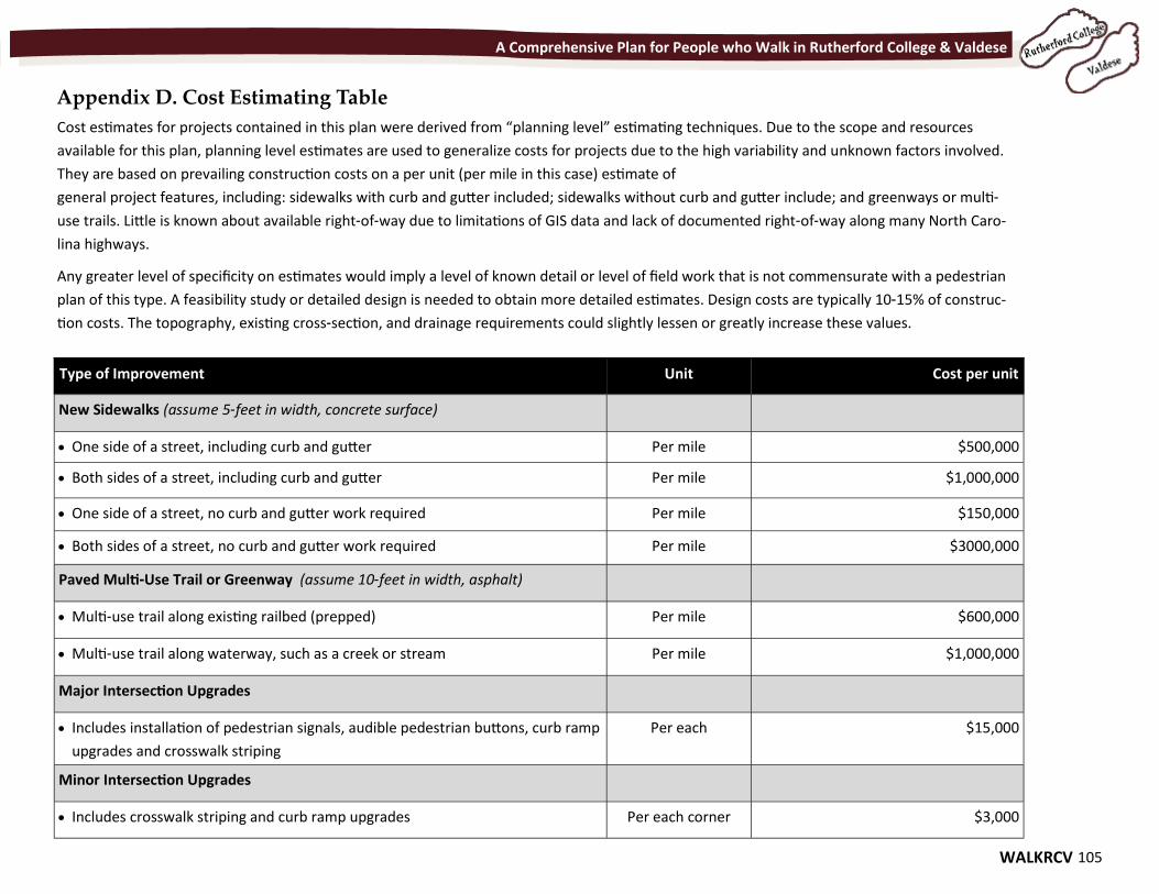
WALKRCV 105
A Comprehensive Plan for People who Walk in Rutherford College & Valdese
Appendix D. Cost Estimating Table
Cost estimates for projects contained in this plan were derived from “planning level” estimating techniques. Due to the scope and resources
available for this plan, planning level estimates are used to generalize costs for projects due to the high variability and unknown factors involved.
They are based on prevailing construction costs on a per unit (per mile in this case) estimate of
general project features, including: sidewalks with curb and gutter included; sidewalks without curb and gutter include; and greenways or multi-
use trails. Little is known about available right-of-way due to limitations of GIS data and lack of documented right-of-way along many North Caro-
lina highways.
Any greater level of specificity on estimates would imply a level of known detail or level of field work that is not commensurate with a pedestrian
plan of this type. A feasibility study or detailed design is needed to obtain more detailed estimates. Design costs are typically 10-15% of construc-
tion costs. The topography, existing cross-section, and drainage requirements could slightly lessen or greatly increase these values.
Type of Improvement Unit Cost per unit
New Sidewalks (assume 5-feet in width, concrete surface)
One side of a street, including curb and gutter Per mile $500,000
Both sides of a street, including curb and gutter Per mile $1,000,000
One side of a street, no curb and gutter work required Per mile $150,000
Both sides of a street, no curb and gutter work required Per mile $3000,000
Paved Multi-Use Trail or Greenway (assume 10-feet in width, asphalt)
Multi-use trail along existing railbed (prepped) Per mile $600,000
Multi-use trail along waterway, such as a creek or stream Per mile $1,000,000
Major Intersection Upgrades
Includes installation of pedestrian signals, audible pedestrian buttons, curb ramp
upgrades and crosswalk striping
Per each $15,000
Minor Intersection Upgrades
Includes crosswalk striping and curb ramp upgrades Per each corner $3,000