Embed Size (px)
Citation preview
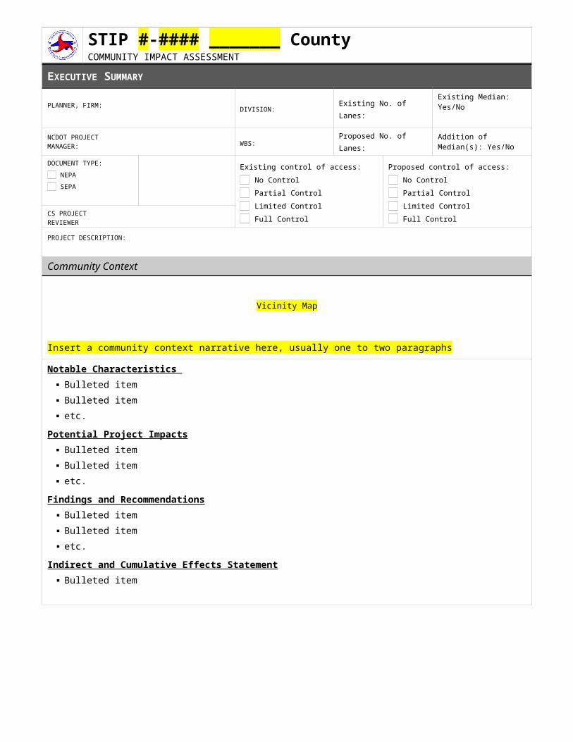
STIP #-#### _______ County COMMUNITY IMPACT ASSESSMENT
EXECUTIVE SUMMARY
PLANNER, FIRM: DIVISION: Existing No. of Lanes:
Existing Median: Yes/No
NCDOT PROJECT MANAGER: WBS:
Proposed No. of Lanes:
Addition of Median(s): Yes/No
DOCUMENT TYPE: NEPA SEPA
Existing control of access: No Control Partial Control Limited Control Full Control
Proposed control of access: No Control Partial Control Limited Control Full ControlCS PROJECT
REVIEWER
PROJECT DESCRIPTION:
Community Context
Vicinity Map
Insert a community context narrative here, usually one to two paragraphsNotable Characteristics
Bulleted item Bulleted item etc.
Potential Project Impacts Bulleted item Bulleted item etc.
Findings and Recommendations Bulleted item Bulleted item etc.
Indirect and Cumulative Effects Statement Bulleted item

STIP #-#### XXXX County COMMUNITY IMPACT ASSESSMENT Month, Year page 2
COMMUNITY CONTEXT MAP
Insert Community Context Map
DEMOGRAPHIC STUDY AREA
Insert DSA Map
STIP #-#### XXXX County COMMUNITY IMPACT ASSESSMENT Month, Year page 3
COMMUNITY CHARACTERISTICS, IMPACTS & RECOMMENDATIONS
Community Resource Presence
RECREATIONAL RESOURCE(S) OR ACTIVITYPresenceAre there any recreational resources, areas, or observed activities in the Direct Community Impact Area? If Federally-funded, are these potential 4(f) resources?
Check the appropriate condition, provide the associated standard language, and include a narrative description as appropriate. If "No," delete this gray text form field.
YES, SEPA Parks & Recreation YES, NEPA potential 4(f);
adjacent to/accessed from the project corridor
YES, NEPA potential 4(f); present in DCIA but not adjacent to or accessed from the project corridor
NO
Impacts Check the appropriate condition, provide the associated standard language, and include a narrative description as appropriate. If "No," delete this gray text form field.
YES, SEPA Impact
YES, potential NEPA impact
NO
Color-coded shading for degree of impact
Recommendation If "Yes," provide narrative description. If "No," delete this gray text form field.
YES
NO
SECTION 6(F) LAND & WATER CONSERVATION FUND RESOURCESPresenceAre there any areas protected under Section 6(f) in the Direct Community Impact Area?
Check the appropriate condition, provide the associated standard language, and include a narrative description as appropriate. If "No," delete this gray text form field.
YES
NO
Impacts Is the project likely to impact identified Section 6(f) Land & Water Conservation Fund Resources?
Check the appropriate condition, provide the associated standard language, and include a narrative description as appropriate. If "No," delete this gray text form field.
YES
NO
Color-coded shading for degree of impact
Recommendation
If "Yes," provide narrative description. If "No," delete this gray text form field.
YES
NO
FARMLAND SOILSPresence Are there any farmland soils within the project footprint?
Check the appropriate condition, provide the associated standard language, and include a narrative description as appropriate. If "No" or "Not applicable," delete this gray text form field.
YES, SEPA YES, NEPA (FPPA) NO, not present Not applicable - urbanized
area
ImpactsIs the project likely to have a notable impact on identified farmland soils?
Check the appropriate condition, provide the associated standard language, and include a narrative description as appropriate. If "Not present," delete this gray text form field.
YES, SEPA conversion YES, NEPA does not exceed
FPPA threshold YES, NEPA exceeds FPPA
threshold NO
RecommendationIf "Yes," provide narrative description. If "No," delete this gray text form field.
YES
NO
STIP #-#### XXXX County COMMUNITY IMPACT ASSESSMENT Month, Year page 4
VOLUNTARY & ENHANCED VOLUNTARY AGRICULTURAL DISTRICTS [VAD/EVAD]PresenceIs there a Voluntary Agricultural District or Enhanced Voluntary Agricultural District in the project footprint?
Check the appropriate condition, provide the associated standard language, and include a narrative description as appropriate. If "No," delete this gray text form field.
YES
NO
Impacts Is the project likely to impact designated Voluntary Agricultural Districts or Enhanced Voluntary Agricultural Districts?
Check the appropriate condition, provide the associated standard language, and include a narrative description as appropriate. If "No," delete this gray text form field.
YES
NO
Color-coded shading for degree of impact
RecommendationIf "Yes," provide narrative description. If "No," delete this gray text form field.
YES
NO
AGRICULTURAL RESOURCES AND ACTIVITYPresenceAre there any active agricultural operations located in the Direct Community Impact Area? Is there any documented activity related to goods movement in the Direct Community Impact Area (e.g. farm or logging trucks, tractors, or other agricultural equipment)?
If "Yes," provide narrative description. If "No," delete this gray text form field.
YES
NO
ImpactsIs the project likely to impact identified agricultural operations?
If "Yes," provide narrative description. If "No," delete this gray text form field.
YES
NO
Color-coded shading for degree of impact
RecommendationIf "Yes," provide narrative description. If "No," delete this gray text form field.
YES
NO
BICYCLE, PEDESTRIAN, AND/OR GREENWAY FACILITIES AND ACTIVE TRANSPORTATIONPresenceAre there existing bicycle, pedestrian, greenway or other active transport facilities located in the Direct Community Impact Area? Are there future plans for bicycle, pedestrian, greenway or active transport facilities to be located in the Direct Community Impact Area?
If "Yes," provide summary inventory of existing facilities and summary inventory of planned future facilities (including timeline and funding status). If "No," delete this gray text form field.
YES
NO
ImpactsIs the project likely to result in impacts to bicycle, pedestrian, and/or greenway facilities?
If "Yes," provide narrative description. If "No," delete this gray text form field.
YES NO
Color-coded shading for degree of impact
RecommendationIf "Yes," provide narrative description. If "No," delete this gray text form field.
YES
NO
BICYCLE/PEDESTRIAN ACTIVITYPresenceWere bicyclists, pedestrians or worn paths observed in the Direct Community Impact Area?
If "Yes," provide narrative description. If "No," delete this gray text form field.
YES
NO
Impacts YES Color-coded
STIP #-#### XXXX County COMMUNITY IMPACT ASSESSMENT Month, Year page 5
Is the project likely to result in impacts to bicycle or pedestrian activity? If "Yes," provide narrative description. If "No," delete this gray text form field.
NO shading for degree of impact
RecommendationIf "Yes," provide narrative description. If "No," delete this gray text form field.
YES
NO
TRANSIT ROUTES, FACILITIES, AND/OR ACTIVITYPresenceAre transit routes present in the Direct Community Impact Area? Were buses, transit stops or route signs observed on the site visit? Were any riders observed using or known to use these facilities? Were any of these riders special users?
If "Yes," provide narrative description. If "No," delete this gray text form field.
YES
NO
ImpactsIs the project likely to result in impacts to transit routes, facilities, and/or activity?
If "Yes," provide narrative description. If "No," delete this gray text form field.
YES
NO
Color-coded shading for degree of impact
RecommendationIf "Yes," provide narrative description. If "No," delete this gray text form field.
YES
NO
LOCAL AREA PLANS, GOALS, AND DEVELOPMENT ACTIVITYPresenceAre there any local area plans, goals, or zoning initiatives specifically affecting the Direct Community Impact Area (e.g. comprehensive plan; corridor or thoroughfare plan; small area plan; long-range growth plan; health impact assessment; etc.)? Has recent development activity occurred in the Direct Community Impact Area and/or are there known plans for public or private development activity in the Direct Community Impact Area?
If "Yes," provide narrative description. If "No," delete this gray text form field.
YES
NO
ImpactsIs the project consistent or notconsistent with existing plans, regulations, and policies at the local, regional, or state level?
If "Not consistent," provide narrative description. If "Consistent," delete this gray text form field.
CONSISTENT
NOT CONSISTENT
Color-coded shading for degree of impact
RecommendationIf "Yes," provide narrative description. If "No," delete this gray text form field.
YES
NO
DRIVEWAYS AND CROSS STREETSPresenceAre there any driveways or intersections located along the project corridor?
If “Yes”, provide summary inventory organized by property access and community connectivity relative to development patterns and land uses. If “No”, delete this gray text form field.
YES
NO
ImpactsIs the project likely to result in access or accessibility impacts to driveways and cross streets?
If "Yes," provide narrative description. If "No," delete this gray text form field.
YES
NO
Color-coded shading for degree of impact
RecommendationIf "Yes," provide narrative description. If "No," delete this gray text form field.
YES
NO
BUSINESS AND ECONOMIC RESOURCES AND TRANSPORTATION ACTIVITYPresenceAre any specific business and/or economic resources present in the Direct Community Impact Area (e.g. business parks or districts, distribution centers, manufacturing facilities, etc.)? Is there any documented activity related to goods movement in
YES
NO
STIP #-#### XXXX County COMMUNITY IMPACT ASSESSMENT Month, Year page 6
the Direct Community Impact Area (e.g. tractor- trailers, or industrial traffic)?
If "Yes," provide narrative description. If "No," delete this gray text form field.
ImpactsIs the project likely to result in impacts to business and economic resources?
If "Yes," provide narrative description. If "No," delete this gray text form field.
YES
NO
Color-coded shading for degree of impact
RecommendationIf "Yes," provide narrative description. If "No," delete this gray text form field.
YES
NO
EMERGENCY MANAGEMENT SERVICES (EMS) OPERATIONSPresenceDid the EMS local official note any emergency services operations within the Direct Community Impact Area that may be affected by the project, such as stations or corridors that are primary response routes?
If "Yes," provide narrative description. If "No," delete this gray text form field.
YES
NO
NO RESPONSE
ImpactsAs checked on Local EMS Input Form
If "Yes," provide narrative description. If "No," delete this gray text form field.
YES
NO
NO RESPONSE
Color-coded shading for degree of impact
RecommendationIf "Yes," provide narrative description. If "No," delete this gray text form field.
YES NO
SCHOOL BUS ROUTES PresenceDid the local school transportation official note any school bus routes within the Direct Community Impact Area that may be affected by the project?
If "Yes," provide narrative description. If "No," delete this gray text form field.
YES
NO
NO RESPONSE
ImpactsAs checked on Local Schools Input Form
If "Yes," provide narrative description. If "No," delete this gray text form field.
YES
NO
NO RESPONSE
Color-coded shading for degree of impact
RecommendationIf "Yes," provide narrative description. If "No," delete this gray text form field.
YES NO
COMMUNITY RESOURCESPresenceAre there any notable community resources located in the Direct Community Impact Area, including places of worship; private and/or public schools; adult education and/or training facilities; daycares; cemeteries; private or public social service agencies; government facilities; other important destinations or resources for local residents?
If "Yes," provide narrative description. If "No," delete this gray text form field.
YES
NO
ImpactsIs the project likely to impact identified community resources, either directly or by affecting user access?
If "Yes," provide narrative description. If "No," delete this gray text form field.
YES
NO
Color-coded shading for degree of impact
RecommendationIf "Yes," provide narrative description. If "No," delete this gray text form field.
YES NO
COMMUNITY COHESIONPresence
YES
NO
STIP #-#### XXXX County COMMUNITY IMPACT ASSESSMENT Month, Year page 7
Were any specific signs or indicators of community cohesion observed / found within the Direct Community Impact Area?
If "Yes," provide narrative description. If "No," delete this gray text form field.
ImpactsIs the project likely to alter the overall functioning of an identifiable district (e.g. interactions between, or isolation of, persons and groups; or change in the physical makeup of the community)? Is the project likely to disrupt connections between neighborhoods and commercial, recreational, institutional and employment facilities and/or areas?
If "Yes," provide narrative description. If "No," delete this gray text form field.
YES
NO
Color-coded shading for degree of impact
RecommendationIf "Yes," provide narrative description. If "No," delete this gray text form field.
YES
NO
COMMUNITY HEALTH AND SAFETYPresenceAre there any existing or perceived crime or safety issues in the Direct Community Impact Area, including unsafe bicycle or pedestrian facilities, inadequate lighting and/or isolated or poorly connected areas?
If "Yes," provide narrative description. If "No," delete this gray text form field.
YES
NO
Impact Is the project likely to change any existing or perceived crime or safety issues?
If "Yes," provide narrative description. If "No," delete this gray text form field.
YES
NO
Color-coded shading for degree of impact
RecommendationIf "Yes," provide narrative description. If "No," delete this gray text form field.
YES
NO
AREA/COMMUNITY CONCERNSPresenceAre there any known community concerns or controversy relative to the project? If concerns were voiced during Public Involvement activities, please attach the relevant comment sheets or meeting comment summary in the Appendix.
If "Yes," provide narrative description. If "No," delete this gray text form field.
YES
NO
ImpactsIs the project likely to be incompatible with or not address community concerns?
If "Yes," provide narrative description. If "No," delete this gray text form field.
YES
NO
Color-coded shading for degree of impact
RecommendationIf "Yes," provide narrative description. If "No," delete this gray text form field.
YES
NO
OTHER IMPACTSAre there any other potential impacts associated with the project?
If "Yes," provide narrative description. If "No," delete this gray text form field.
YES
NO
Color-coded shading for degree of impact
RecommendationIf "Yes," provide narrative description. If "No," delete this gray text form field.
YES
NO
RECURRING EFFECTSImpactsIs the project likely to result in recurring effects on any populations and communities within the Direct Community Impact Area?
If "Yes," provide narrative description. If "No," delete this gray text form field.
YES
NO
Color-coded shading for degree of impact
Recommendation YES
NO
STIP #-#### XXXX County COMMUNITY IMPACT ASSESSMENT Month, Year page 8
If "Yes," provide narrative description. If "No," delete this gray text form field.
ENVIRONMENTAL JUSTICE (EJ) AND TITLE VI POPULATIONSPresenceAre there any populations living in the Demographic Study Area that meet the criteria for Environmental Justice and/or Title VI? If so, note which groups are present (check all that apply): Minority Low-Income Title VI (non-EJ)
Check the appropriate condition, provide the associated standard language, and include a narrative description as appropriate. If "No," delete this gray text form field.
Not present according to Census data and observation/local input
Present; Census data indicates presence but there is no observation/local input to confirm
Present; Census data does not indicate presence but communities were observed
Present according to Census and communities were observed
ImpactsIs the project likely to have a disproportionately high and adverse impact, including denial of benefits, on identified Environmental Justice and/or Title VI populations in the Direct Community Impact Area?
Check the appropriate condition, provide the associated standard language, and include a narrative description as appropriate. If "No impacts," delete this gray text form field.
No impacts; no EJ or Title VI population present
No impacts; EJ and/or Title VI population present
Community Impacts; no EJ or Title VI population present
Impacts; EJ and/or Title VI population present; “No” finding
Impacts; EJ and/or Title VI population present; “Yes” finding
RecommendationIf "Yes," provide narrative description. If "No," delete this gray text form field.
YES
NO
LIMITED ENGLISH PROFICIENCY [LEP] OR LANGUAGE ASSISTANCE [LA] POPULATIONSPresenceAre there any populations living in the Demographic Study Area that meet the criteria for Limited English Proficiency? Are there any populations within the Demographic Study Area that do not meet the LEP threshold but do meet the criteria for Language Assistance?
Check the appropriate condition, provide the associated standard language, and include a narrative description as appropriate. If "No LEP or LA," delete this gray text form field.
No LEP or LA No LEP, but LA population is
present LEP population present [and LA population present]
RecommendationIf "Yes," provide narrative description. If "No," delete this gray text form field.
YES
NO
ADDITIONAL COMMUNITY CHARACTERISTICS
NOTABLE POPULATION GROWTH OR DECLINEPresenceHas the DSA experienced notable population growth or decline in recent years? If the average annualized DSA population growth is higher than 1.5%, note the growth in the county and how it compares. Decline Greater than 1.5% annual growth (in DSA)
If "Yes," provide narrative description. If "No," delete this gray text form field.
YES
NO
STIP PROJECTSPresenceAre there any reasonably foreseeable STIP projects within 3 miles of this project and/or that have the potential to affect or be affected by this project?
If "Yes," provide narrative description. If "No," delete this gray text form field.
YES
NO
TRAFFIC GENERATING FACILITY OR NODE YES
STIP #-#### XXXX County COMMUNITY IMPACT ASSESSMENT Month, Year page 9
PresenceIs there a node or facility that generates a notable level of vehicular or pedestrian traffic in the Direct Community Impact Area?
If "Yes," provide narrative description. If "No," delete this gray text form field.
NO
ADDITIONAL RECOMMENDATIONS
EVALUATE ALTERNATIVE(S) THAT UTILIZE A TEMPORARY ON-SITE DETOURIf "Yes," provide narrative description. If "No," delete this gray text form field.
YES
NO
EVALUATE ALTERNATIVE CONSTRUCTION WORK SCHEDULESIf "Yes," provide narrative description. If "No," delete this gray text form field.
YES
NO
OTHER RECOMMENDATIONSIf "Yes," provide narrative description. If "No," delete this gray text form field.
YES
NO
SOURCES Source 1Source 2etc.
APPENDIX ITEMS A. Summary of Demographics Used in Tabular FormB. Site PhotographsC. Local Official Input FormsD. Preliminary Screening of Farmland Conversion ImpactsE. Health Indicators TableF. Other Information
STIP #-#### XXXX County COMMUNITY IMPACT ASSESSMENT Month, Year page 10
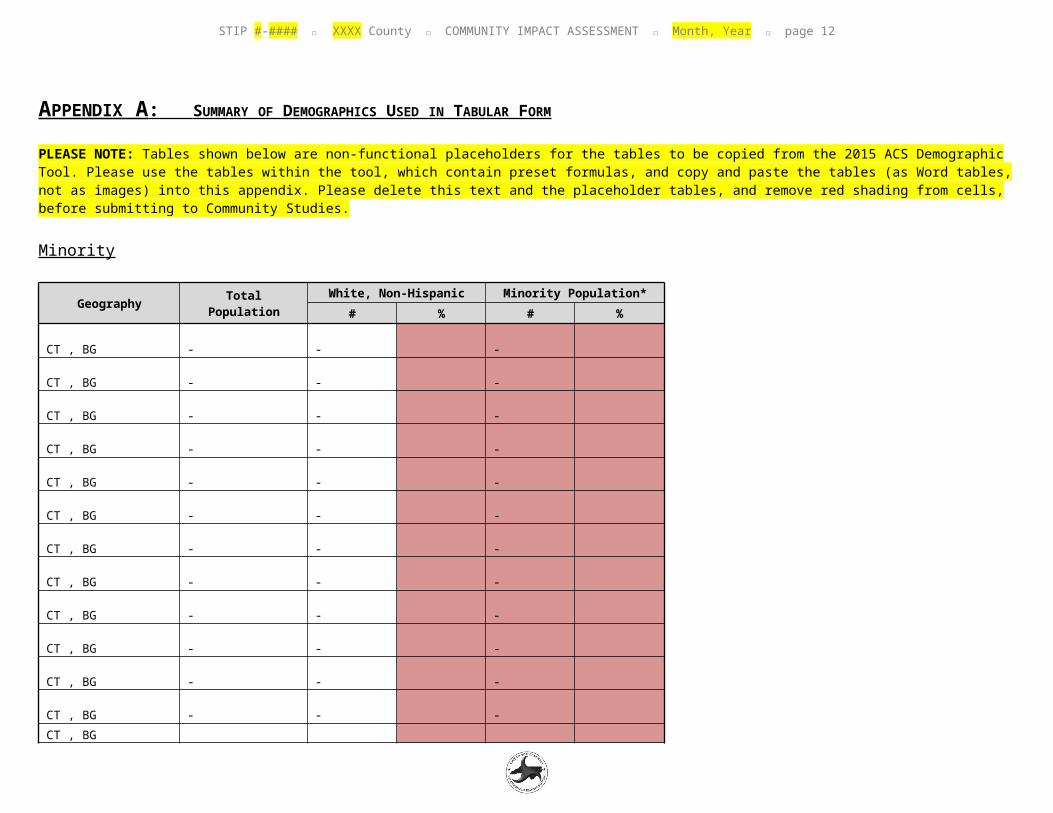
APPENDIX A : SUMMARY OF DEMOGRAPHICS USED IN TABULAR FORM
PLEASE NOTE: Tables shown below are non-functional placeholders for the tables to be copied from the 2015 ACS Demographic Tool. Please use the tables within the tool, which contain preset formulas, and copy and paste the tables (as Word tables, not as images) into this appendix. Please delete this text and the placeholder tables, and remove red shading from cells, before submitting to Community Studies.
Minority
Geography Total PopulationWhite, Non-Hispanic Minority Population*
# % # %
CT , BG -
-
-
CT , BG -
-
-
CT , BG -
-
-
CT , BG -
-
-
CT , BG -
-
-
CT , BG -
-
-
CT , BG -
-
-
CT , BG -
-
-
CT , BG -
-
-
CT , BG -
-
-
CT , BG -
-
-
CT , BG -
-
-
CT , BG -
-
-
CT , BG -
-
-
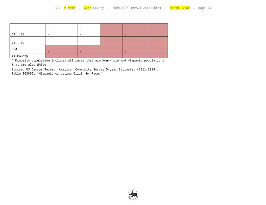
STIP #-#### XXXX County COMMUNITY IMPACT ASSESSMENT Month, Year page 11
CT , BG -
-
-
DSA -
-
-
XX County * Minority population includes all races that are Non-White and Hispanic populations that are also White.
Source: US Census Bureau, American Community Survey 5-year Estimates (2011-2015), Table B03002, "Hispanic or Latino Origin by Race."
STIP #-#### XXXX County COMMUNITY IMPACT ASSESSMENT Month, Year page 12
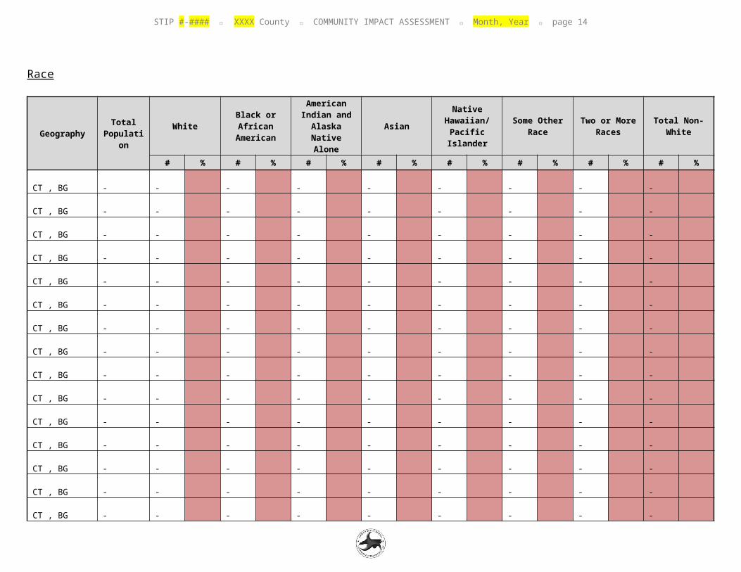
Race
GeographyTotal
Population
WhiteBlack or African
American
American Indian and
Alaska Native Alone
AsianNative
Hawaiian/Pacific
Islander
Some Other Race
Two or More Races
Total Non-White
# % # % # % # % # % # % # % # %
CT , BG -
-
-
-
-
-
-
-
-
CT , BG -
-
-
-
-
-
-
-
-
CT , BG -
-
-
-
-
-
-
-
-
CT , BG -
-
-
-
-
-
-
-
-
CT , BG -
-
-
-
-
-
-
-
-
CT , BG -
-
-
-
-
-
-
-
-
CT , BG -
-
-
-
-
-
-
-
-
CT , BG -
-
-
-
-
-
-
-
-
CT , BG -
-
-
-
-
-
-
-
-
CT , BG -
-
-
-
-
-
-
-
-
CT , BG -
-
-
-
-
-
-
-
-
CT , BG -
-
-
-
-
-
-
-
-
CT , BG -
-
-
-
-
-
-
-
-
CT , BG -
-
-
-
-
-
-
-
-
CT , BG -
-
-
-
-
-
-
-
-
DSA -
-
-
-
-
-
-
-
-
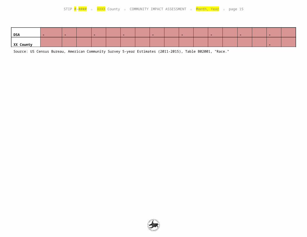
XX County
STIP #-#### XXXX County COMMUNITY IMPACT ASSESSMENT Month, Year page 13
-
Source: US Census Bureau, American Community Survey 5-year Estimates (2011-2015), Table B02001, "Race."
STIP #-#### XXXX County COMMUNITY IMPACT ASSESSMENT Month, Year page 14
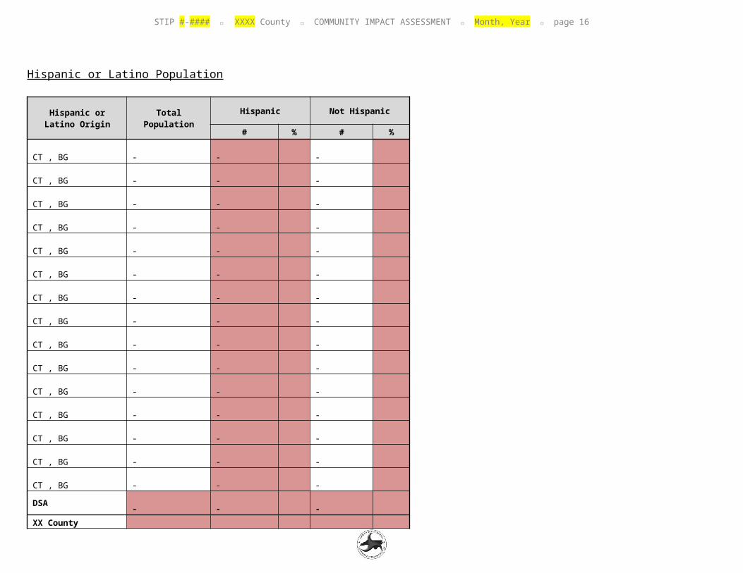
Hispanic or Latino Population
Hispanic or Latino Origin Total Population
Hispanic Not Hispanic
# % # %
CT , BG - - -
CT , BG - - -
CT , BG - - -
CT , BG - - -
CT , BG - - -
CT , BG - - -
CT , BG - - -
CT , BG - - -
CT , BG - - -
CT , BG - - -
CT , BG - - -
CT , BG - - -
CT , BG - - -
CT , BG - - -
CT , BG - - -
DSA - - -
XX County Source: US Census Bureau, American Community Survey 5-year Estimates (2011-2015), Table
STIP #-#### XXXX County COMMUNITY IMPACT ASSESSMENT Month, Year page 15
B03002, "Hispanic or Latino Origin by Race."
STIP #-#### XXXX County COMMUNITY IMPACT ASSESSMENT Month, Year page 16
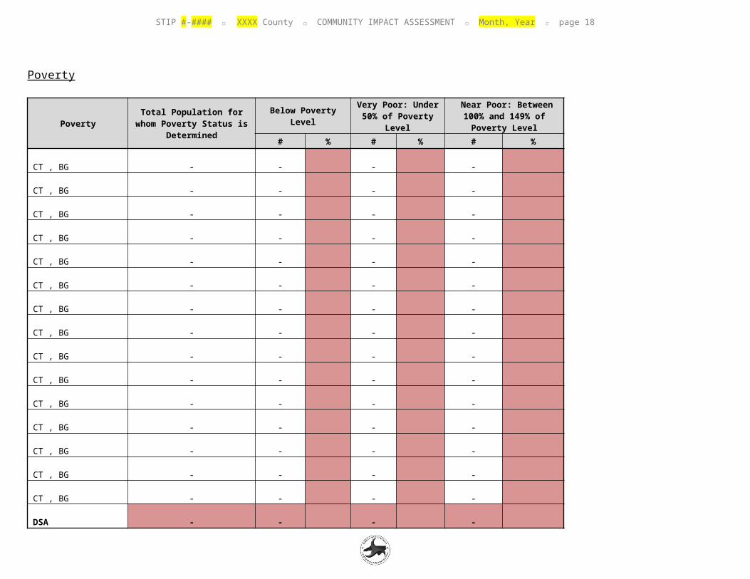
Poverty
PovertyTotal Population for whom
Poverty Status is Determined
Below Poverty LevelVery Poor: Under 50% of Poverty
Level Near Poor: Between 100% and 149% of Poverty Level
# % # % # %
CT , BG -
-
-
-
CT , BG -
-
-
-
CT , BG -
-
-
-
CT , BG -
-
-
-
CT , BG -
-
-
-
CT , BG -
-
-
-
CT , BG -
-
-
-
CT , BG -
-
-
-
CT , BG -
-
-
-
CT , BG -
-
-
-
CT , BG -
-
-
-
CT , BG -
-
-
-
CT , BG -
-
-
-
CT , BG -
-
-
-
CT , BG -
-
-
-
DSA -
-
-
-
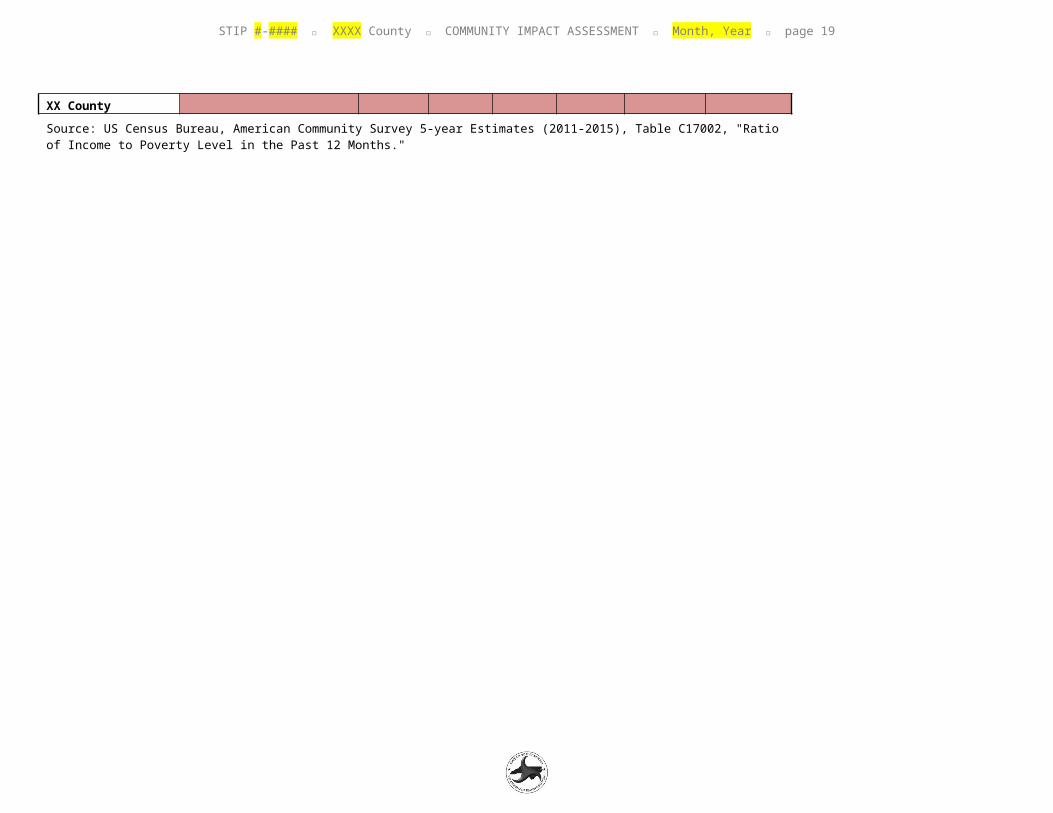
XX County Source: US Census Bureau, American Community Survey 5-year Estimates (2011-2015), Table C17002, "Ratio of Income to Poverty Level
STIP #-#### XXXX County COMMUNITY IMPACT ASSESSMENT Month, Year page 17
in the Past 12 Months."
STIP #-#### XXXX County COMMUNITY IMPACT ASSESSMENT Month, Year page 18
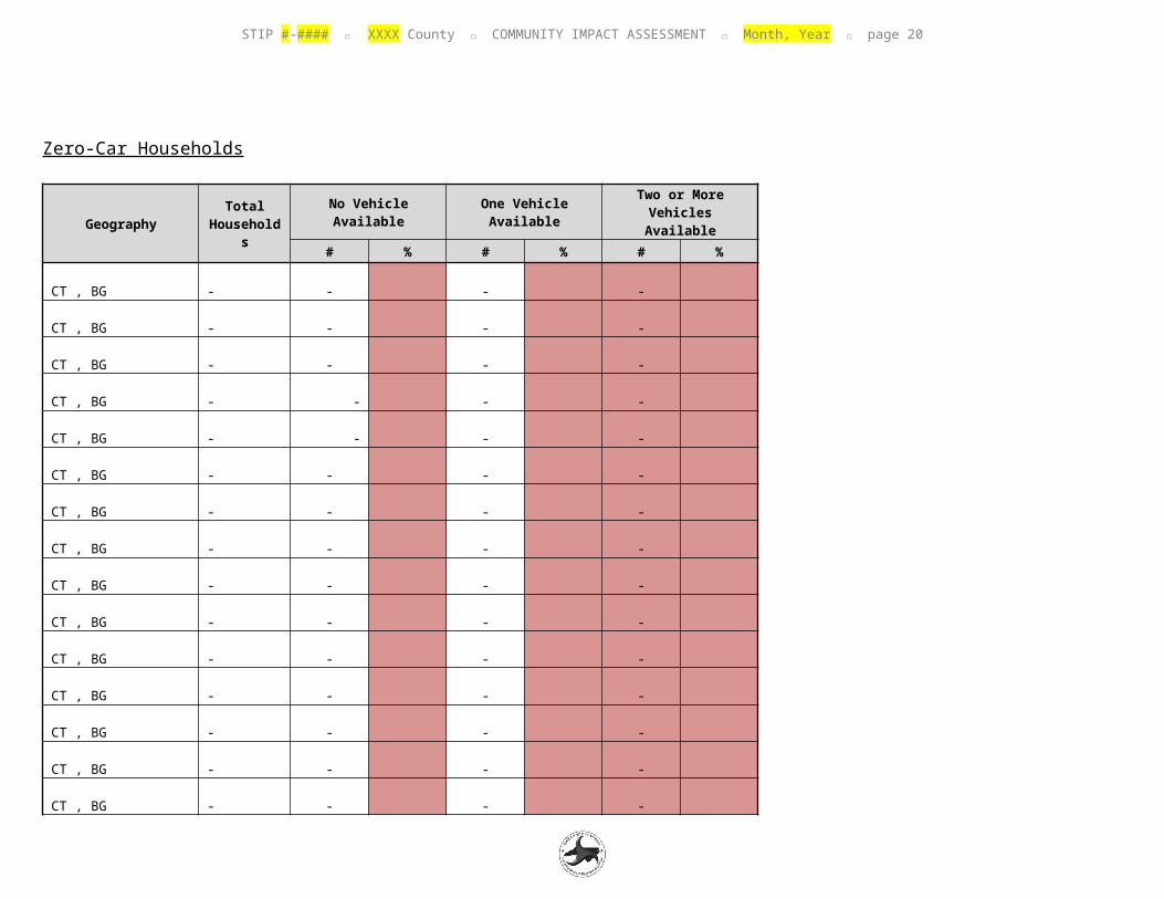
Zero-Car Households
GeographyTotal
Households
No Vehicle Available One Vehicle Available Two or More Vehicles Available
# % # % # %
CT , BG -
-
-
-
CT , BG -
-
-
-
CT , BG -
-
-
-
CT , BG -
-
-
-
CT , BG -
-
-
-
CT , BG -
-
-
-
CT , BG -
-
-
-
CT , BG -
-
-
-
CT , BG -
-
-
-
CT , BG -
-
-
-
CT , BG -
-
-
-
CT , BG -
-
-
-
CT , BG -
-
-
-
CT , BG -
-
-
-
CT , BG -
-
-
-
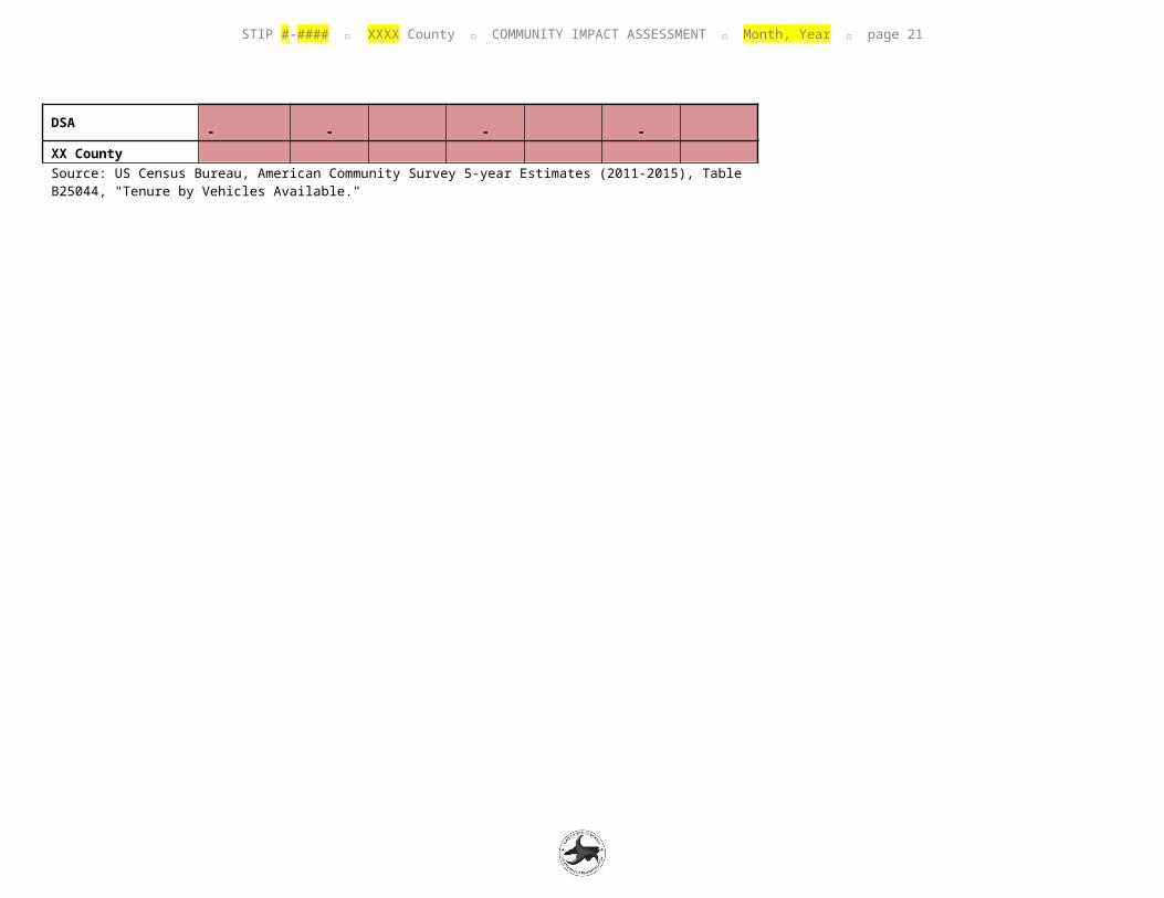
DSA -
-
-
-
XX County
STIP #-#### XXXX County COMMUNITY IMPACT ASSESSMENT Month, Year page 19
Source: US Census Bureau, American Community Survey 5-year Estimates (2011-2015), Table B25044, "Tenure by Vehicles Available."
STIP #-#### XXXX County COMMUNITY IMPACT ASSESSMENT Month, Year page 20
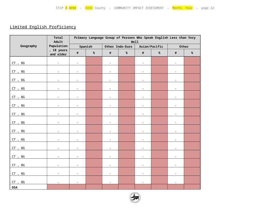
Limited English Proficiency
GeographyTotal Adult Population,
18 years and older
Primary Language Group of Persons Who Speak English Less than Very WellSpanish Other Indo-Euro Asian/Pacific Other
# % # % # % # %
CT , BG -
-
-
-
-
CT , BG -
-
-
-
-
CT , BG -
-
-
-
-
CT , BG -
-
-
-
-
CT , BG -
-
-
-
-
CT , BG -
-
-
-
-
CT , BG -
-
-
-
-
CT , BG -
-
-
-
-
CT , BG -
-
-
-
-
CT , BG -
-
-
-
-
CT , BG -
-
-
-
-
CT , BG -
-
-
-
-
CT , BG -
-
-
-
-
CT , BG -
-
-
-
-
CT , BG -
-
-
-
-
DSA -
-
-
-
-
STIP #-#### XXXX County COMMUNITY IMPACT ASSESSMENT Month, Year page 21
Source: US Census Bureau, American Community Survey 5-year Estimates (2011-2015), Table B16004, "Age by Language Spoken at Home by Ability to Speak English for the Population 5 Years and Over."
STIP #-#### XXXX County COMMUNITY IMPACT ASSESSMENT Month, Year page 22
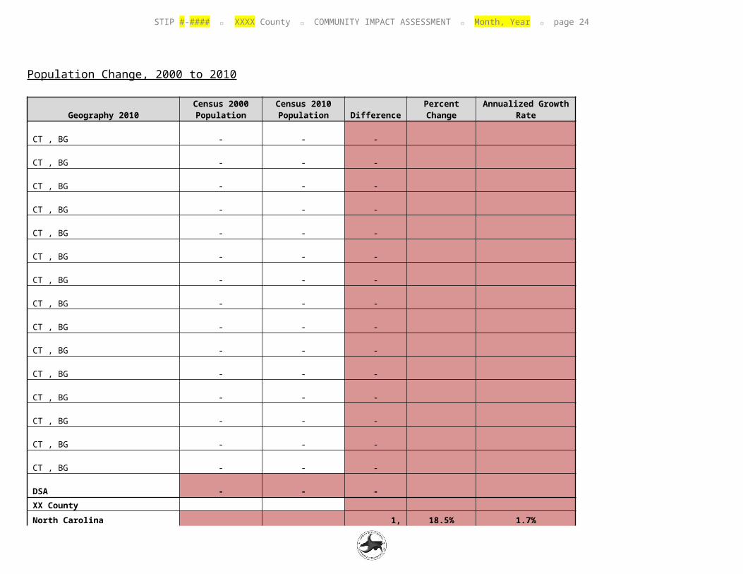
Population Change, 2000 to 2010
Geography 2010Census 2000 Population
Census 2010 Population Difference
Percent Change
Annualized Growth Rate
CT , BG -
-
-
CT , BG -
-
-
CT , BG -
-
-
CT , BG -
-
-
CT , BG -
-
-
CT , BG -
-
-
CT , BG -
-
-
CT , BG -
-
-
CT , BG -
-
-
CT , BG -
-
-
CT , BG -
-
-
CT , BG -
-
-
CT , BG -
-
-
CT , BG -
-
-
CT , BG -
-
-
DSA -
-
-
XX County
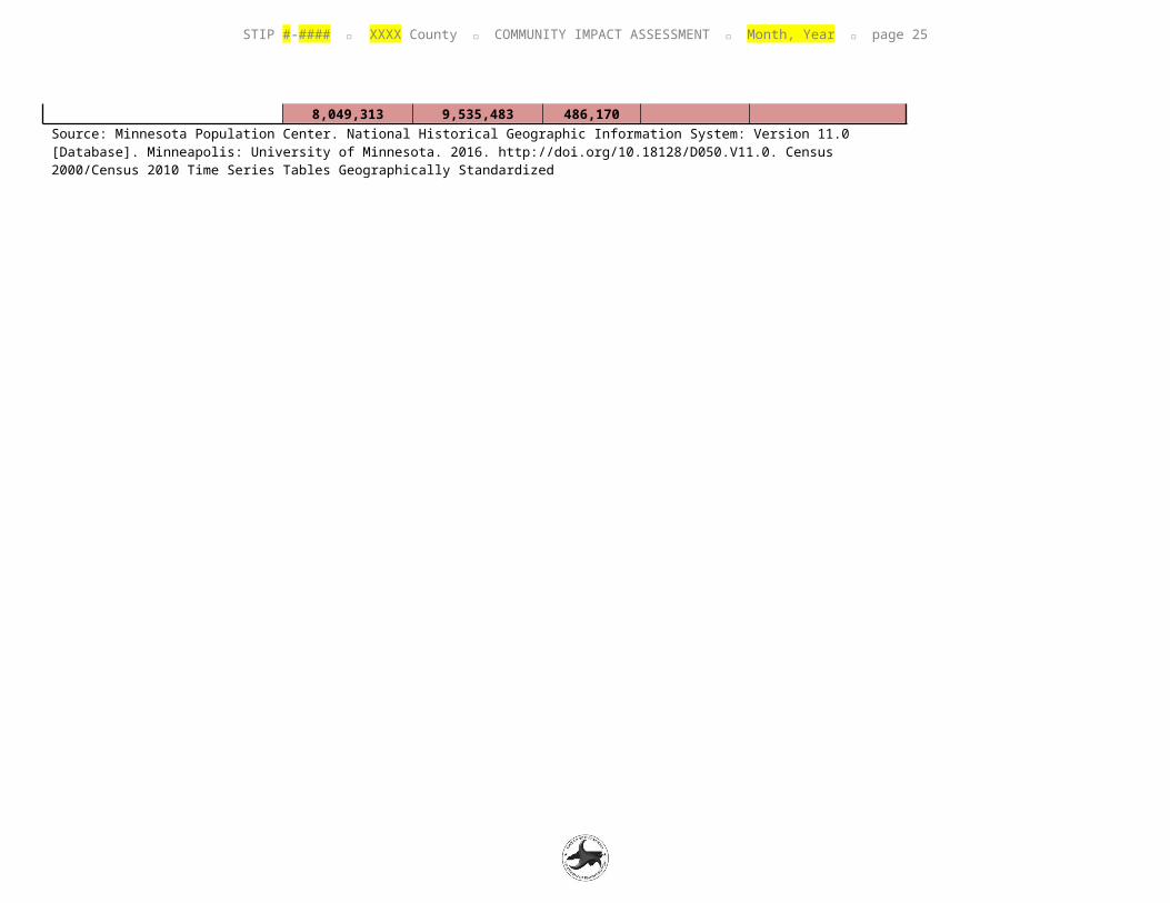
North Carolina 8,049,3
13 9,535,4
83 1,486,17
0 18.5% 1.7%Source: Minnesota Population Center. National Historical Geographic Information System: Version 11.0 [Database]. Minneapolis: University of
STIP #-#### XXXX County COMMUNITY IMPACT ASSESSMENT Month, Year page 23
Minnesota. 2016. http://doi.org/10.18128/D050.V11.0. Census 2000/Census 2010 Time Series Tables Geographically Standardized
STIP #-#### XXXX County COMMUNITY IMPACT ASSESSMENT Month, Year page 24
APPENDIX B : SITE PHOTOGRAPHS
Figure 1: Figure 2:
Figure 3: Figure 4:
Figure 5: Figure 6:
STIP #-#### XXXX County COMMUNITY IMPACT ASSESSMENT Month, Year page 25
APPENDIX C : LOCAL OFFICIAL INPUT FORMS
Complete the tables below to document the results of local official contacts – EMS, planner, schools. If more than one EMS official, planner, or school official is contacted (for example, multiple jurisdictions), then include a table for each.
First Contact Date: Enter the date of the first contact attempt.
Method(s): Check the applicable box(es).
Form returned on: Check this box if the form is returned via email, fax, or snail mail. Include the date.
Interview on: Check this box if you interviewed the contact person by phone or in-person. Include the date.
No response: Check this box if you do not receive a response or are unable to reach the person by the time that you submit the report to Community Studies.
Comments: Examples of comments include date of last contact attempt (only if no response), returned blank or incomplete form.
Attach completed Local Official Input Forms on the Local EMS Input Form, Local Planner Input Form, and Local Schools Input Form pages. If there is no response, insert the text “No response received.”
LOCAL EMS
Name: Title: Agency:Phone:Email:
Click here to enter text.Click here to enter text.Click here to enter text.Click here to enter text.Click here to enter text.
FIRST CONTACT DATE METHOD(S) RESULTClick here to enter date. ☐ Email
☐ Phone☐ In-person
☐ Form returned on (date)☐ Interview on (date)☐ No responseComments:
STIP #-#### XXXX County COMMUNITY IMPACT ASSESSMENT Month, Year page 26
LOCAL PLANNER
Name: Title: Agency:Phone:Email:
Click here to enter text.Click here to enter text.Click here to enter text.Click here to enter text.Click here to enter text.
FIRST CONTACT DATE METHOD(S) RESULTClick here to enter date. ☐ Email
☐ Phone☐ In-person
☐ Form returned on (date)☐ Interview on (date)☐ No responseComments:
LOCAL SCHOOLS
Name: Title: Agency:Phone:Email:
Click here to enter text.Click here to enter text.Click here to enter text.Click here to enter text.Click here to enter text.
FIRST CONTACT DATE METHOD(S) RESULTClick here to enter date. ☐ Email
☐ Phone☐ In-person
☐ Form returned on (date)☐ Interview on (date)☐ No responseComments:

STIP #-#### XXXX County COMMUNITY IMPACT ASSESSMENT Month, Year page 27
Local EMS Input Form
Insert completed form here
STIP #-#### XXXX County COMMUNITY IMPACT ASSESSMENT Month, Year page 28
Local Planner Input Form
Insert completed form here
STIP #-#### XXXX County COMMUNITY IMPACT ASSESSMENT Month, Year page 29
Local Schools Input Form
Insert completed form here

STIP #-#### XXXX County COMMUNITY IMPACT ASSESSMENT Month, Year page 30
APPENDIX D : PRELIMINARY SCREENING OF FARMLAND CONVERSION IMPACTS
Insert NRCS Farmland Figure (Size 6.5” x 8”)

STIP #-#### XXXX County COMMUNITY IMPACT ASSESSMENT Month, Year page 31
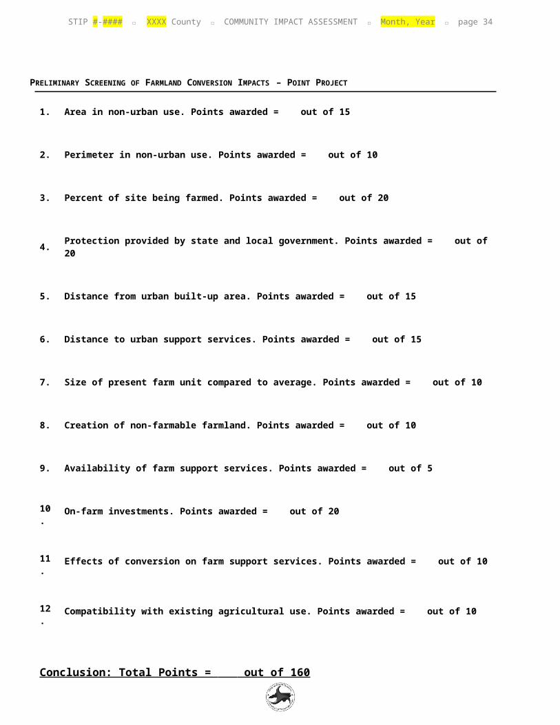
PRELIMINARY SCREENING OF FARMLAND CONVERSION IMPACTS – POINT PROJECT
1. Area in non-urban use. Points awarded = out of 15
2. Perimeter in non-urban use. Points awarded = out of 10
3. Percent of site being farmed. Points awarded = out of 20
4. Protection provided by state and local government. Points awarded = out of 20
5. Distance from urban built-up area. Points awarded = out of 15
6. Distance to urban support services. Points awarded = out of 15
7. Size of present farm unit compared to average. Points awarded = out of 10
8. Creation of non-farmable farmland. Points awarded = out of 10
9. Availability of farm support services. Points awarded = out of 5
10. On-farm investments. Points awarded = out of 20
11. Effects of conversion on farm support services. Points awarded = out of 10
12. Compatibility with existing agricultural use. Points awarded = out of 10
Conclusion: Total Points = out of 160 NCDOT has completed a screening of farmland in the project area and calculated the total number of points for the site per Part VI of the NRCS AD-1006 Farmland Conversion Impact Rating Form.

STIP #-#### XXXX County COMMUNITY IMPACT ASSESSMENT Month, Year page 32
PRELIMINARY SCREENING OF FARMLAND CONVERSION IMPACTS – CORRIDOR PROJECT
1. Area in non-urban use. Points awarded = out of 15
2. Perimeter in non-urban use. Points awarded = out of 10
3. Percent of site being farmed. Points awarded = out of 20
4. Protection provided by state and local government. Points awarded = out of 20
5. Size of present farm unit compared to average. Points awarded = out of 10
6. Creation of non-farmable farmland. Points awarded = out of 25
7. Availability of farm support services. Points awarded = out of 5
8. On-farm investments. Points awarded = out of 20
9. Effects of conversion on farm support services. Points awarded = out of 25
10. Compatibility with existing agricultural use. Points awarded = out of 10
Conclusion: Total Points = out of 160 NCDOT has completed a screening of farmland in the project area and calculated the total number of points for the site per Part VI of the NRCS CPA-106 Farmland Conversion Impact Rating Form.

STIP #-#### XXXX County COMMUNITY IMPACT ASSESSMENT Month, Year page 33
APPENDIX E : HE ALTH INDICATORS TABLE
CHARACTERISTICSMALLEST DATA LEVEL
X-XXXX DSA XXXX COUNTYNORTH CAROLINA
DATA SOURCE NOTES
Number of Pedestrian or Bicyclist Crashes in DCIA (Ped/Bike) DCIA (XX/XX)
http://ncdot.maps.arcgis.com/home/webmap/viewer.html?useExisting=1
Count the number of crashes within the DCIA from 2007-2012 using NCDOT’s Bicyclist and Pedestrian Crash Map.
Average Pedestrian Crash Rate City X.XX 2.77http://www.pedbikeinfo.org/pbcat_nc/
Crashes per 10,000 residents, avg. of 2008-2012 crash totals, 2010 pop
Average Bicyclist Crash Rate City X.XX 1.03http://www.pedbikeinfo.org/pbcat_nc/
Crashes per 10,000 residents, avg. of 2008-2012 crash totals, 2010 pop
Physical Inactivity County XX.X% 25.0%
http://www.countyhealthrankings.org/app/north-carolina/2014/overview
Percent of adults aged 20+ reporting no leisure-time physical activity, 2010
Access to exercise opportunities County XX.X% 65.0%
http://www.countyhealthrankings.org/app/north-carolina/2014/overview
Percentage of individuals who reside in a census block within a half mile of a park or (urban) one mile of a rec. facility or (rural) three miles of a rec. facility, 2010 & 2012
STIP #-#### XXXX County COMMUNITY IMPACT ASSESSMENT Month, Year page 34
APPENDIX F : OTHER INFORMATION
Examples include public meeting summaries, comments from local officials, and local plan maps.


![[XLS] · Web viewtables Cartago Heredia Puntarenas SAN JOSE](https://img.pdfslide.net/doc/110x75/5aa3c8357f8b9a2f048b56c4/xls-viewtables-cartago-heredia-puntarenas-san-jose.jpg)
