Embed Size (px)
Citation preview

Date: 5-11 2012
Professor: Toru OtawaDesigner: Jesse Ward
Class: LARC 465
Sheet:1 of 5
Introduction
To create a trail-head that promotes community and provides a pleasant area with access to the near-by trail, while being sustainable and promoting town identity.
Goals and Objectives Programming
Provide locations for snow removal and appropriate widths for snowmobiling and cross-country skiing.
Problem Statement:
Location
Activities:- To create a place that many people can enjoy- A place to experience different activities and events
Sustainable:- Use water-wise methods in design- Consider erosion and storm-water man-agement- Use limited irrigation- Use methods to prevent flooding of town
Promote Surrounding Natural Beauty:- Design an enjoyable and relaxing area for people to gather and enjoy themselves and the surroundings
Provide Trail Access:- Design an easy access from the town to the near-by trail.
Increase Town Identity:- Help promote identity and town pride.
Accessibility:- Design for easy site access for everyone.
Provide for Community Needs:- Provide for the other needs of the com-munity and site.
Design for Year-Round Use:- Allowing for enjoyment all year-round.
Improve the ice rank. Design an amphithe-ater that can fulfill the needs of various cer-emonies like; weddings, concerts and other events. Also include a dog park, keep baseball a part of the design. Provide access to hiking, install an area for picnick-ing with tables, make available to cross-country skiing and snowmobile access in the winter.
Use native plants and implement vegetation and bio-swales to manage soil erosion and manage storm-water. Possibly catch the storm-water and snow melt and use it for irrigation.
Provide openings and good sitting areas to enjoy the views. Possibly add informa-tional signs that depict the names of the surrounding mountains.
Appropriate signage for trail and markers to indicate the starts. Also, have a place with trail information and maps at the site.
Develop the park to fit in with and reflect the town. Use community involvement where possible in imple-mentation of the site improvements.
Design in consideration with ADA standards. ADA being the American Disabilities Act. This would have paths being a minimum of 3’ wide and the slope on ramps being a max of 8.33% slope. Also, using direc-tion signs to communicate what the site offers and where key features are located.
Use the community in the construction of site, provide requested activities. Improving/relocating the mainte-nance shed, provide restrooms on site.
Goals and Objectives Programming
PIO
NEE
R P
AR
K &
RED
FISH
TR
AIL
-HEA
D
business2community.com
joseandblancaphotography.com
singletracks.com
identity-theft-faq.com
graphicartistsguild.org
keota.k12.ia.us
all-free-download.com
je�onesillustration.com
PIO
NEE
R P
AR
K &
RED
FISH
TR
AIL
-HEA
D
Date: 5-11-2012
Professor: Toru OtawaDesigner: Jesse Ward
Class: LARC 465
Sheet:2 of 5
Inventory and Analysis
Watershed
LegendrcassslopeValue
0 - 5
5 - 8.33
8.33 - 12
12 <
LegendrcassslopeValue
0 - 5
5 - 8.33
8.33 - 12
12 <
Slope
The majority of the site is relatively flat with the max slope being 34deg, making ADA accessibil-ity possible. Most of the site has under a 5 degree slope that slopes toward a gully and toward the town. Do to the direction of the slope, it will be very important to manage storm-water and snow-melt to prevent it from running into the town. A good place for the placing of the management features would be in the steeper, less usable area of the site.
This chart shows the where the water goes. It flows into a large gully that carries it to the city and then the river. Adequate elements to catch the water will have to be put in place to prevent this runoff from reaching the town.
The soil on the site is a concern as it has poor drainage. Because of this, ad-equate drainage systems will have to be established. A good location to catch water would be in the ravine on the east of the site. This would catch the water from flowing into and flooding the town and could be later used for irrigation.
Soil
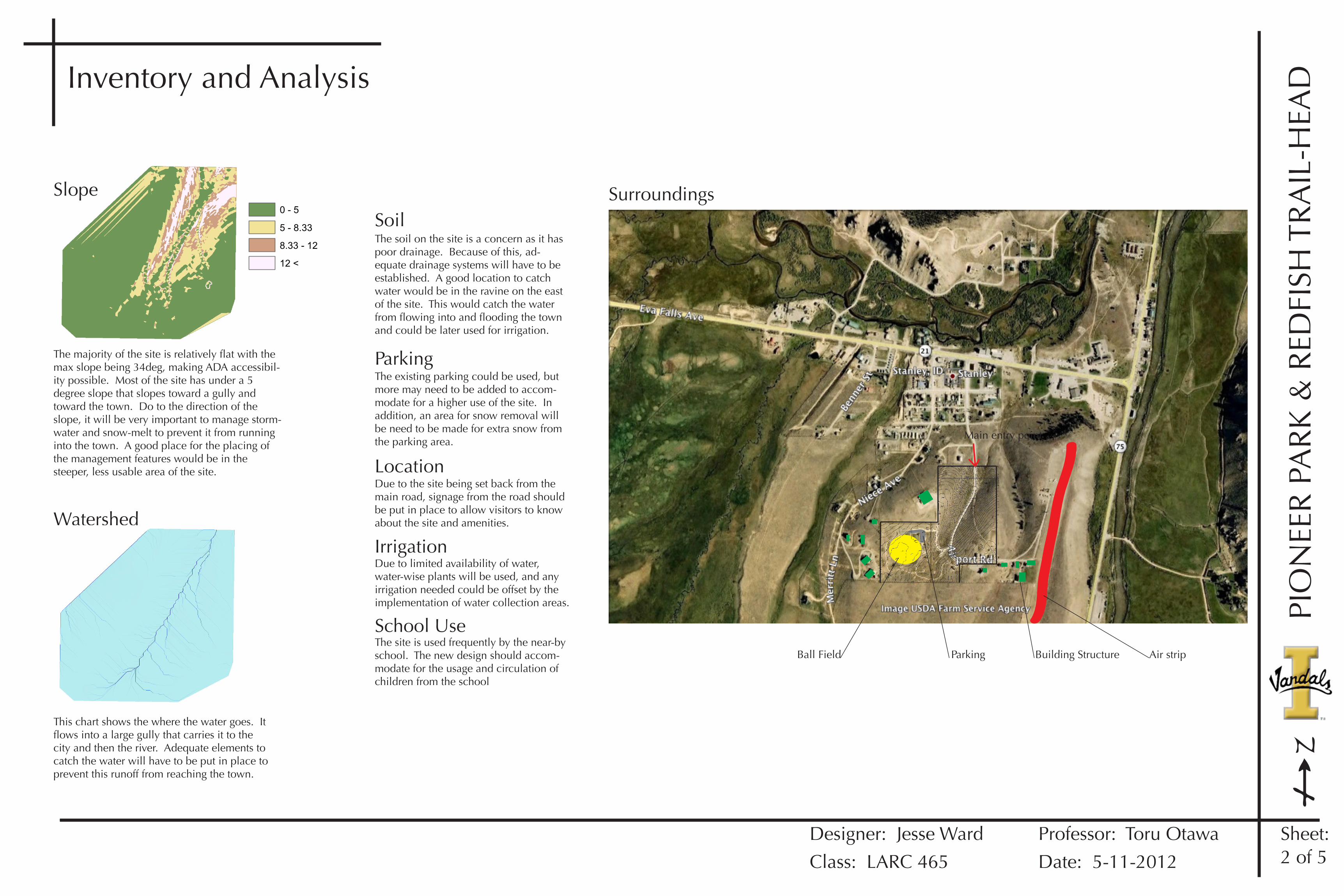
Air strip
Surroundings
Building StructureBall Field Parking
The existing parking could be used, but more may need to be added to accom-modate for a higher use of the site. In addition, an area for snow removal will be need to be made for extra snow from the parking area.
Parking
Due to the site being set back from the main road, signage from the road should be put in place to allow visitors to know about the site and amenities.
Location
Due to limited availability of water, water-wise plants will be used, and any irrigation needed could be offset by the implementation of water collection areas.
Irrigation
The site is used frequently by the near-by school. The new design should accom-modate for the usage and circulation of children from the school
School Use
Main entry point

Date: 5-11-2012
Professor: Toru OtawaDesigner: Jesse Ward
Class: LARC 465
Sheet:3 of 5
PIO
NEE
R P
AR
K &
RED
FISH
TR
AIL
-HEA
D
Ball Field
Storm Water Management
Parking
Playground
Vehicular Transport
Pedestrian Paths
Frisbee GolfHoles
Picnic/Viewing areas
Amp.Picnic
Dog Park
Multi-use
Bio-swale
Ice Rink
Parking
Multi-use
Maintenance shedRestrooms
Sledding
Multi-use
Multi-use
Amp.
Ball Field
Dog Park
Sledding
Bio-swale
ParkingPlayground
Vehicular Transport
Pedestrian Paths
Frisbee GolfHoles
Picnic/Viewing areas
Ice RinkBall Field
Bio-swale
Parking
Playground
Vehicular Transport
Pedestrian Paths
Frisbee GolfHoles
Picnic/Viewing areas
Amp.
Picnicking
Dog Park
Multi-use
Bio-swale
Ice Rink
Sledding
These concepts attempt to keep existing features in their existing locations with new elements being added around them. All of the paths are wide enough for maintenance vehicles and for snowmobiling or cross-country skiing in the winter. The concepts try to bring out the good existing conditions and add in order to improve the experience.
This first concept uses the lower portion of the site for water managements and collection. The amphithe-ater is in the action are of the site near the ball field.
This concept moves some of the water management area to higher up on the site to prevent how far the water flows to reduce erosion. A larger picnic area is also added near the chapel for events to be held. The amphitheater is moved lower on the site to get it away from the noise of the ball field and to make better use of the slope for seating.
This concept leaves a lot in the same area as concept 2, but moves the amphitheater closer to the chapel for better use in weddings or other ceremonies. Also, additional parking is added near the chapel to better accommodate ceremonies.
Restrooms
Maintenance Shed
Parking
Sledding
Multi-use
Bio-swale
PicnicPicnic
Multi-use
Dog Park
Playground
Ice Rink
Ball Field Amp.
This concept attempts keep everything as condensed as possible. The purpose of that is to leave as much of the site as possible open to any use. Something that is important in a park is to have the freedom to do many things in many places. This is the purpose of this idea.
RestroomsMaintenance Shed
Parking
Sledding
Multi-use
Bio-swale
Picnic
Picnic
Multi-use
Dog Park
Playground
Ice Rink
Ball FieldAmp.
Trail head Sign/entrance
Vehicle route
Pedestrian route
To Town
ConceptsConcept 1 Concept 2 Concept 3
Concept 4
Overall
The final concept is arrived at by studying the other concepts to see what works and what doesn’t or what could be improved. It takes that information and puts it together in order to make a more complete idea. It attempts to group things together for easier access and to allow for more open space on the site. If there is already existing element, like the ice rink, then it reuses it at the current location.
Final Concept

Date: 5-11-2012
Professor: Toru OtawaDesigner: Jesse Ward
Class: LARC 465
Sheet:4 of 5
PIO
NEE
R P
AR
K &
RED
FISH
TR
AIL
-HEA
DMaster plan
Ice Rink (See plan page 4)
Amphitheater (See plan page 4)
Ball �eld
Parking
Picnic
Picnic
Dog park
Bio-swale
Existing historic cabin
Existing historiccabin
Restroom andmaintenance shed
Existing picnic shelter
Trail head signage
To Red�sh Lake
Entry signage
Shrub Bu�er
Memorial Grove
Playground
050
100150
200Scale
Final Plan:This final plan accommodates the needs of the town into a comprehen-sive plan. Existing elements are kept in about the same area in order to keep costs down.
Storm-water:The bio-swale is basically a planted ditch that would capture water runoff to prevent erosion and flooding. It uses existing topography and runs down the swale on the west of the road.
Grass over�ow Parking
Parking:The overflow parking would just be an open grass area that could be used for extra parking during events.
Paths:The paths are all 10 feet wide to ac-commodate snowmobiling. This would also allow them to be wide enough for maintenance vehicles to use for access.

Date: 5-11-2012
Professor: Toru OtawaDesigner: Jesse Ward
Class: LARC 465
Sheet:5 of 5
PIO
NEE
R P
AR
K &
RED
FISH
TR
AIL
-HEA
DOther Plans & Visuals
Amphitheater
Ice Rink
A
B
B
A
C
C
010
2030
40Scale
010
2030
40Scale
The Amphitheater is designed large enough to accommodate large events. Each step rises about 2 ft. and is 10 ft. deep to allow for movable chairs if desired. The lower plaza is large enough for a band and dancing. There is lighting, but it’s minimal and would be about 10 ft. high to avoid light pollution to the town.
This plan shows an added plaza around part of the ice rink. This would enable easier viewing of hockey games or people skating. It would also be a pleasant area to come sit in the warmer months, and enjoy the view.