Embed Size (px)
Citation preview
WATER ALLOCATION WATER ALLOCATION IN THE BRANTAS RIVER BASININ THE BRANTAS RIVER BASIN
Jasa Tirta I Public Corporation
2005
JASA TIRTA I PUBLIC CORPORATIONJl. Surabaya 2A, Malang – 65115 Indonesia
Telp. (0341) 551971, Fax. (0341) 551976Email: [email protected]://www.jasatirta1.go.id Sertifikat No. ID03 / 0127
22
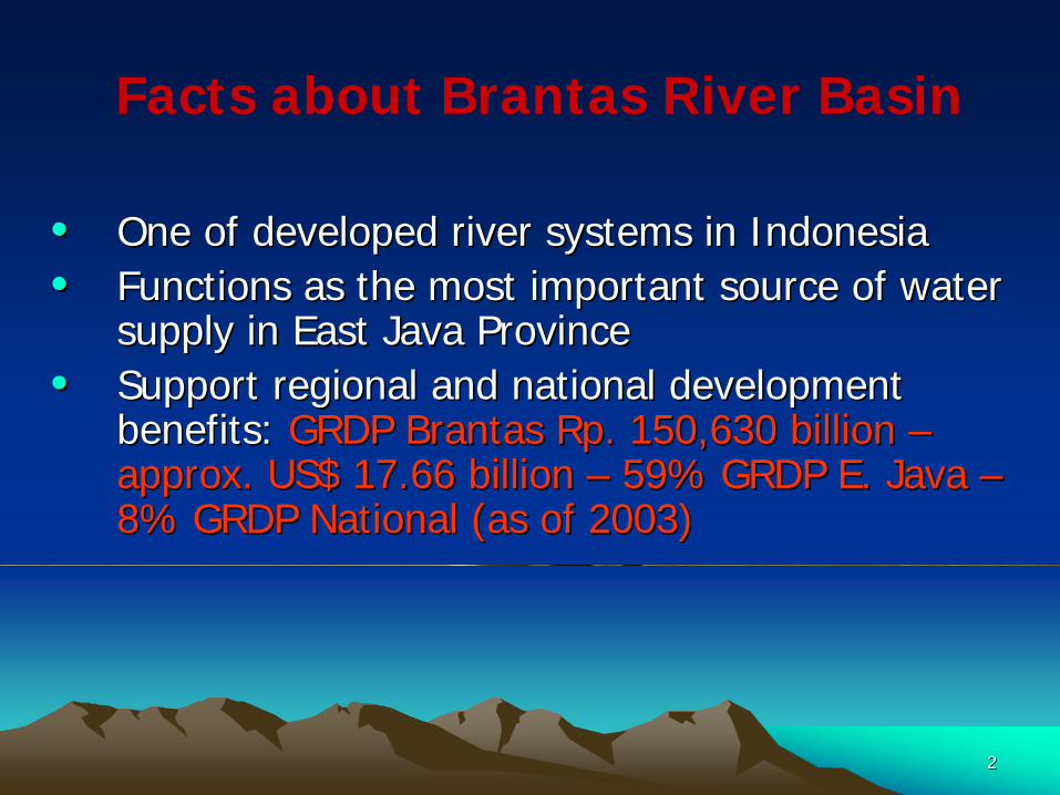
Facts about Brantas River Basin
•• One of developed river systems in IndonesiaOne of developed river systems in Indonesia•• Functions as the most important source of water Functions as the most important source of water
supply in East Java Provincesupply in East Java Province•• Support regional and national development Support regional and national development
benefits: benefits: GRDP BrantasGRDP Brantas RpRp. 150,630 billion . 150,630 billion ––approx. US$ 17.66 billion approx. US$ 17.66 billion –– 59% GRDP E. Java 59% GRDP E. Java ––8% GRDP National (as of 2003)8% GRDP National (as of 2003)
33
East Java
East Java
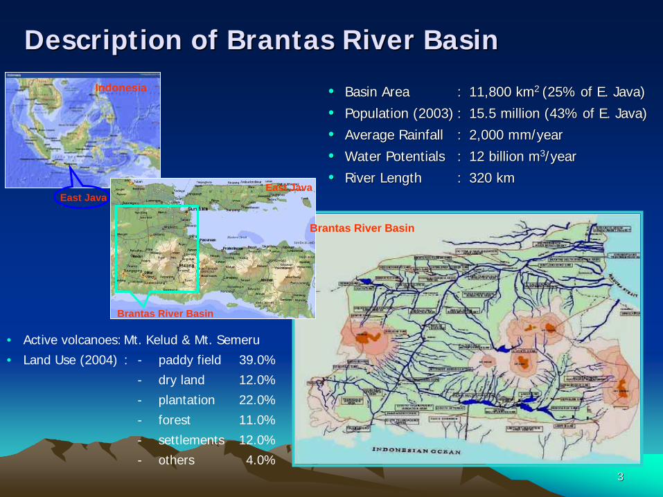
Description of Brantas River Basin Description of Brantas River Basin
•• Basin AreaBasin Area :: 11,800 km11,800 km2 2 (25% of E. Java) (25% of E. Java)
•• Population (2003)Population (2003) :: 15.5 million (43% of E. Java)15.5 million (43% of E. Java)
•• Average RainfallAverage Rainfall :: 2,000 mm/year2,000 mm/year
•• Water PotentialsWater Potentials :: 12 billion m12 billion m33/year/year
•• River LengthRiver Length :: 320 km 320 km
• Active volcanoes:Mt. Kelud & Mt. Semeru
• Land Use (2004) : - paddy field 39.0%
- dry land 12.0%
- plantation 22.0%
- forest 11.0%
- settlements 12.0%
- others 4.0%
Indonesia
Brantas River Basin
East Java
Brantas River Basin
44
Wonorejo Dam (00)
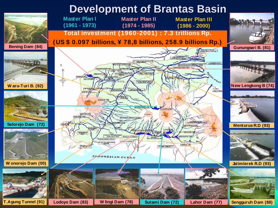
Development of Brantas BasinDevelopment of Brantas BasinMaster Plan I(1961 - 1973)
Master Plan II(1974 - 1985)
Master Plan III(1986 - 2000)
Sengguruh Dam (88)Sutami Dam (72)T.Agung Tunnel (91)
Selorejo Dam (72)
Waru-Turi B. (92)
Bening Dam (84) Gunungsari B. (81)
Menturus R.D (93)
Jatimlerek R.D (93)
Wlingi Dam (78)Lodoyo Dam (83) Lahor Dam (77)
New Lengkong B (74)
Total investment (1960-2001) : 7.3 trillions Rp. (US $ 0.097 billions, ¥ 78,8 billions, 258.9 billions Rp.)
55
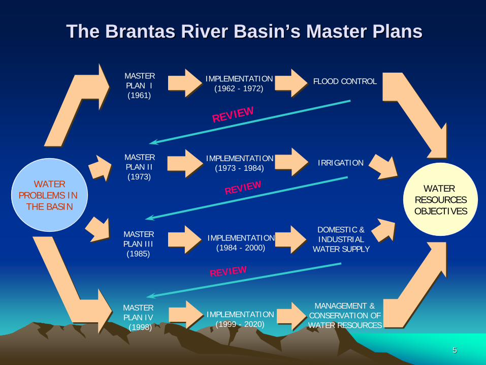
WATER RESOURCESOBJECTIVES
WATERPROBLEMS IN
THE BASIN
MASTERPLAN II(1973)
MASTER PLAN I(1961)
MASTERPLAN III(1985)
IMPLEMENTATION(1962 - 1972)
IMPLEMENTATION(1973 - 1984)
IMPLEMENTATION(1984 - 2000)
FLOOD CONTROL
IRRIGATION
DOMESTIC &INDUSTRIAL
WATER SUPPLY
REVIEW
MASTERPLAN IV
(1998)
IMPLEMENTATION(1999 - 2020)
MANAGEMENT &CONSERVATION OFWATER RESOURCES
REVIEW
REVIEW
The Brantas River BasinThe Brantas River Basin’’s Master Planss Master Plans
66
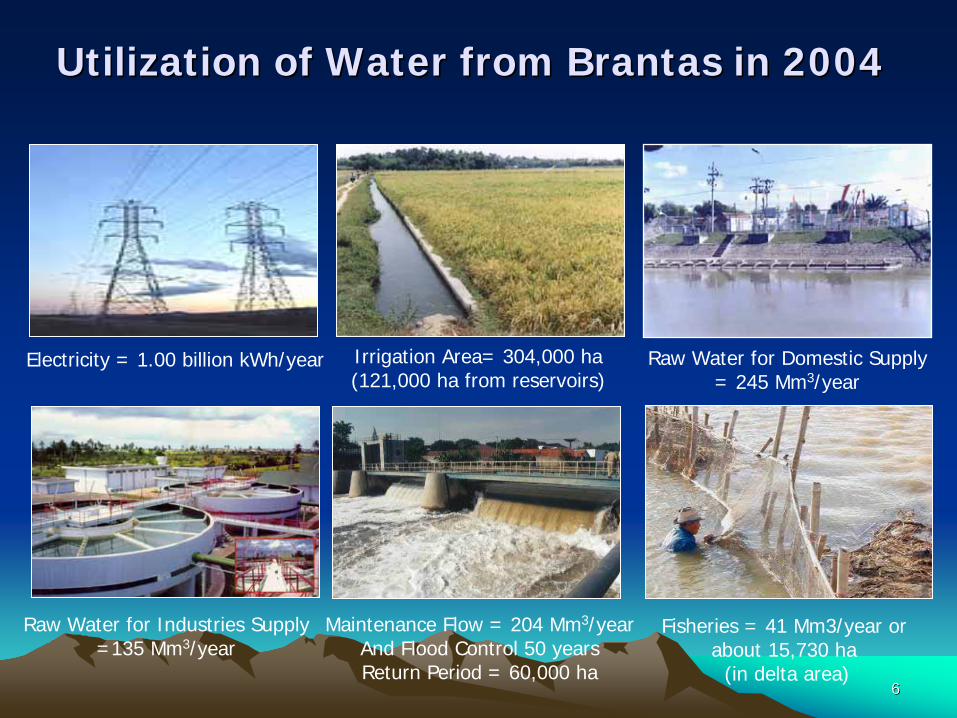
Electricity = 1.00 billion kWh/year Raw Water for Domestic Supply = 245 Mm3/year
Irrigation Area= 304,000 ha(121,000 ha from reservoirs)
Raw Water for Industries Supply =135 Mm3/year
Maintenance Flow = 204 Mm3/yearAnd Flood Control 50 yearsReturn Period = 60,000 ha
Fisheries = 41 Mm3/year or about 15,730 ha
(in delta area)
Utilization of Water from Brantas in 2004Utilization of Water from Brantas in 2004
77
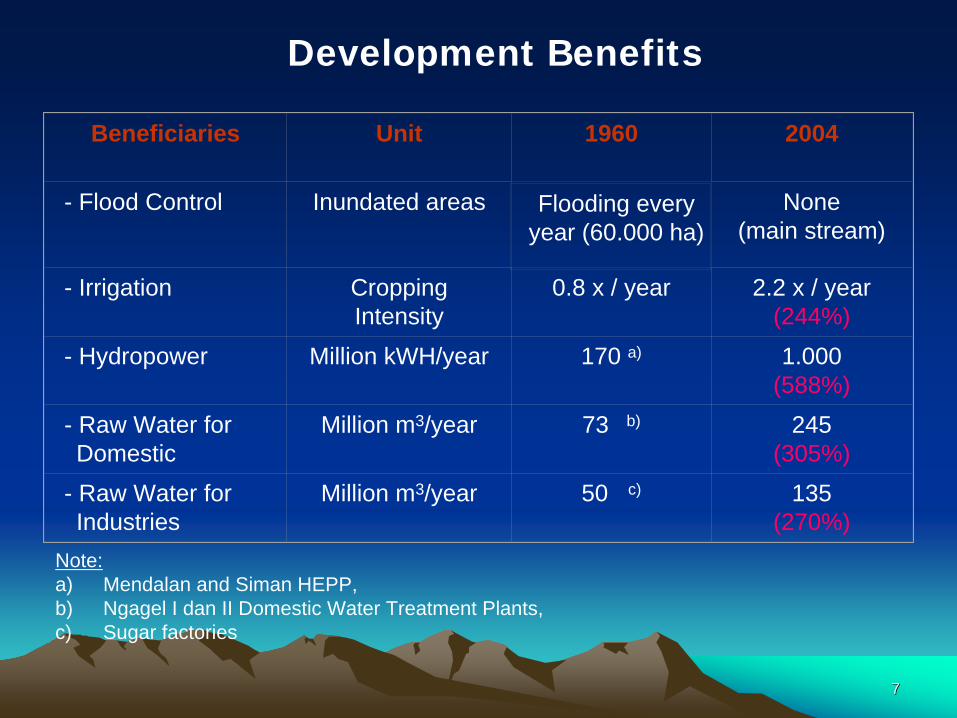
Beneficiaries Unit 1960 2004
- Flood Control Inundated areas Flooding every year (60.000 ha)
None(main stream)
- Irrigation Cropping Intensity
0.8 x / year 2.2 x / year (244%)
- Hydropower Million kWH/year 170 a) 1.000 (588%)
- Raw Water for Domestic
Million m3/year 73 b) 245 (305%)
- Raw Water for Industries
Million m3/year 50 c) 135 (270%)
Note: a) Mendalan and Siman HEPP, b) Ngagel I dan II Domestic Water Treatment Plants, c) Sugar factories
Development Benefits
88
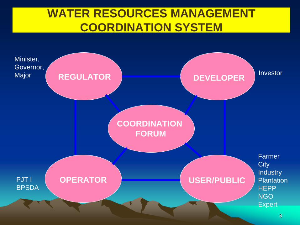
REGULATOR
OPERATOR
DEVELOPER
USER/PUBLIC
COORDINATION FORUM
Minister, Governor,Major Investor
FarmerCityIndustryPlantationHEPPNGOExpert
PJT IBPSDA
WATER RESOURCES MANAGEMENT COORDINATION SYSTEM

99
• Calculation of water demand (for irrigation, generated electricity,
industry, drinking water, fishery, flushing and others) by East
Java Water Resources Service (EJWRS) and Jasa Tirta I Public
Corporation (PJT I)
• Calculation of water availability based on climate, rainfall, inflow
and storage prediction
• Preparing draft of reservoir operation pattern by PJT I. Reservoir
operation pattern is prepared twice a year (wet season and dry
season). It is prepared into three (3) alternatives, i.e. wet,
normal, and dry pattern
Water Allocation Preparation Water Allocation Preparation in the Brantas in the Brantas River Basin (1/2)River Basin (1/2)
1010
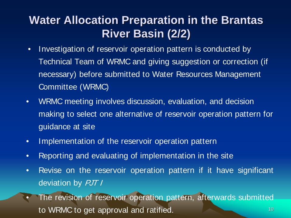
• Investigation of reservoir operation pattern is conducted by
Technical Team of WRMC and giving suggestion or correction (if
necessary) before submitted to Water Resources Management
Committee (WRMC)
• WRMC meeting involves discussion, evaluation, and decision
making to select one alternative of reservoir operation pattern for
guidance at site
• Implementation of the reservoir operation pattern
• Reporting and evaluating of implementation in the site
• Revise on the reservoir operation pattern if it have significant
deviation by PJT I
• The revision of reservoir operation pattern, afterwards submitted
to WRMC to get approval and ratified.
Water Allocation Preparation Water Allocation Preparation in the Brantas in the Brantas River Basin (2/2)River Basin (2/2)
1111Y N
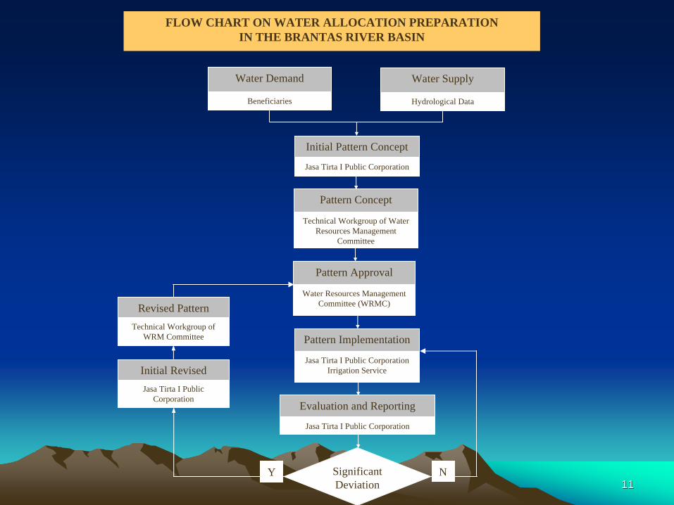
Water Demand
Beneficiaries
Water Supply
Hydrological Data
Initial Pattern Concept
Jasa Tirta I Public Corporation
Pattern Implementation
Jasa Tirta I Public CorporationIrrigation Service
Evaluation and Reporting
Jasa Tirta I Public Corporation
Significant Deviation
Revised Pattern ConceptTechnical Workgroup of
WRM Committee
Pattern Concept
Technical Workgroup of Water Resources Management
Committee
Pattern Approval
Water Resources Management Committee (WRMC)
Initial Revised Pattern ConceptJasa Tirta I Public
Corporation
FLOW CHART ON WATER ALLOCATION PREPARATIONIN THE BRANTAS RIVER BASIN
1212
Indonesian Ocean
Madura Strait
BRANTAS RIVER
P. A
GUN
G C
ANAL
P. RAYA CA
NAL
BRANTAS RIVER
WIDAS RIVER
LESTI RIVER
KONTO
RIVER
BRANTAS RIVER
WONOKROMO RIVER
SURABAYA RIVER
MA
S R
IVER
PORONG RIVER
PASURUAN
SIDOARJO
MOJOKERTO
JOMBANG
NGANJUK
TULUNGAGUNGTRENGGALEK
BLITAR
MALANG
KEDIRI
LAHOR DAM
SUTAMI DAMSENGGURUH DAM
WLINGI DAM
LODOYO DAM
TULUNGAGUNG DIVERSION TUNNELS
MRICAN BARRAGE
BENING DAM
SELOREJO DAM
NEW LENGKONG DAM
GUNUNGSARI DAM
500
1000
15002000
MT. SEMERUMT. SEMERU
MT. PENANJAKANMT. PENANJAKAN
1000
2500
MT. ARJUNAMT. ARJUNA
MT. KELUDMT. KELUD
500
1000
1500
1500
MT. KAWIMT. KAWI
MT. WILISMT. WILIS
500
1000
1500
SUMETERA KALIMANTAN
SULAWESI
Java SeaJakarta
Bandung
Surabaya
LOCATION MAP
Indonesian Sea
SURABAYA
TAWANGREJENI
PONDOK KOBONGREPEATER STATION
∃
GADANGWAGIR
BIROWO
,
SUMBERAGUNG
SEMEN
DOKO
WATES WLINGI
TUNGGORONOTUGU
KAMPAK
BENDO
TANGGUNG
INLET GATE
PAGERWOJO
JELI
WILIS
WATES
WATES SAWAHAN
BERBEK
LENGKONG WIDAS
KERTOSONO
PLOSO
PERNING
PORONG
TAMPUNG
0 5
S C A L E
2010 KM
N
f5f4
WONOREJO DAM
SEGAWE WEIR
TIUDAN HEADWORKTA PUMP STA.
NGUJANG
JATIMLETREK RUBBER DAM
MENTURUS RUBBER DAM
::
PELAYARAN
KARANGPILANG
Figure 1. Existing FFWS (1990)
MALANG OFFICE
TULUNGAGUNGOFFICE
MLIRIP GATE
PORONG CANALMANGETAN CANAL
MRICAN KN. IRG.MRICAN KR. IRG.
LODAGUNG IRG.
PUJON
TANGKIL11 PONCOKUSUMO2
DAMPIT3
4
5
6
7
89
10
11
12
13
21
1514
25
26
16
22
23
19
18
17 20
24
4
3 2
567
8
9
10
11
12
13
14
1516
17
1918
20
21
LEGEND :: Water Level Gauging Station
: Rainfall Gauging Station
Indonesian Ocean
Madura Strait
BRANTAS RIVER
P. A
GUN
G C
ANAL
P. RAYA CA
NAL
BRANTAS RIVER
WIDAS RIVER
LESTI RIVER
KONTO
RIVER
BRANTAS RIVER
WONOKROMO RIVER
SURABAYA RIVER
MA
S R
IVER
PORONG RIVER
PASURUAN
SIDOARJO
MOJOKERTO
JOMBANG
NGANJUK
TULUNGAGUNGTRENGGALEK
BLITAR
MALANG
KEDIRI
LAHOR DAM
SUTAMI DAMSENGGURUH DAM
WLINGI DAM
LODOYO DAM
TULUNGAGUNG DIVERSION TUNNELS
MRICAN BARRAGE
BENING DAM
SELOREJO DAM
NEW LENGKONG DAM
GUNUNGSARI DAM
500
1000
15002000
MT. SEMERUMT. SEMERU
MT. PENANJAKANMT. PENANJAKAN
1000
2500
MT. ARJUNAMT. ARJUNA
MT. KELUDMT. KELUD
500
1000
1500
1500
MT. KAWIMT. KAWI
MT. WILISMT. WILIS
500
1000
1500
SUMETERA KALIMANTAN
SULAWESI
Java SeaJakarta
Bandung
Surabaya
LOCATION MAP
Indonesian Sea
SUMETERA KALIMANTAN
SULAWESI
Java SeaJakarta
Bandung
Surabaya
LOCATION MAP
Indonesian Sea
SURABAYA
TAWANGREJENI
PONDOK KOBONGREPEATER STATION
∃
GADANGWAGIR
BIROWO
,
SUMBERAGUNG
SEMEN
DOKO
WATES WLINGI
TUNGGORONOTUGU
KAMPAK
BENDO
TANGGUNG
INLET GATE
PAGERWOJO
JELI
WILIS
WATES
WATES SAWAHAN
BERBEK
LENGKONG WIDAS
KERTOSONO
PLOSO
PERNING
PORONG
TAMPUNG
0 5
S C A L E
2010 KM0 5
S C A L E
2010 KM
NN
f5f4
WONOREJO DAM
SEGAWE WEIR
TIUDAN HEADWORKTA PUMP STA.
NGUJANG
JATIMLETREK RUBBER DAM
MENTURUS RUBBER DAM
::
PELAYARAN
KARANGPILANG
Figure 1. Existing FFWS (1990)
MALANG OFFICE
TULUNGAGUNGOFFICE
MLIRIP GATE
PORONG CANALMANGETAN CANAL
MRICAN KN. IRG.MRICAN KR. IRG.
LODAGUNG IRG.
PUJON
TANGKIL11 PONCOKUSUMO2
DAMPIT3
4
5
6
7
89
10
11
12
13
21
1514
25
26
16
22
23
19
18
17 20
24
4
3 2
567
8
9
10
11
12
13
14
1516
17
1918
20
21
LEGEND :: Water Level Gauging Station
: Rainfall Gauging Station
LEGEND :: Water Level Gauging Station
: Rainfall Gauging Station
MALANGMaster Station
MALANG
BLITAR
NGANJUK
PLOSO
JOMBANG
KERTOSONO
KEDIRI
PORONG
SURABAYA
Mt. Semeru
GentengRiver
Lesti River
BrantasRiver
AmprongRiver
Metro R
iver
ManisRiver
LeksoRiverPutihRiver
AbabRive
rLaha
rRive
r
WediRiver
BrantasRiverNgrowoRiver
Parit A
gungParit Raya
Konto RiverKuncirRiver
WidasRiver
SrinjingRiver
MarmoyoRiver
BangsalRiver
CemboroRiver
KukubanRiver`PorongRiver
Surabaya River
MasRiver`
Mt. Arjuna
Mt. KawiMt. Kelud
Mt. Wilis
MADURA ISLAND
Mt. Butak
SIDOARJO
TRENGGALEK
Brantas River
Indonesian Ocean
JambeRiver
Mt. Bromo
MaduraStrait
TULUNGAGUNGHydro Power
BENINGDAM MOJOKERTO
TULUNGAGUNG
BodengRiver
Song RiverWONOREJO DAM
SEGAWE DAMCONNECTION
TUNNEL
LAHOR DAMCONNECTION
TUNNEL
TULUNGAGUNGTunnel I & II
Tawing R
iver
TuguRive
r NgasinanRiver
JumoRiver
KlanturRiver
KalidawirRiver
BabakanRiver
PandansariRiverBruniRiver
KedokRiver
LaharRiver
BeningRiver
PajaranRiver
UloRiver
SemaRiver
KedungRiver
KedungsukoRiver
JantiRiver
Putih Shortcut
EwuhRive
r
JariR
iver
SemutRiver
Aran-aran River
TemplekRiver
MantenRiver
BangoRiver
KambingRiver
SadarRiver
Gembolo
River
PucangRiver
KaringanRiver
Tambang AgungRiver
WonokromoRiver
KedurusRiver
WatudakonRiver
BengRiver
BadakRiver
Jimbe
River
Lemon River
PONDOK KOBONGRepeater Station
SELOPURO
JABUNG
MADYOPURO
WILISRepeater Station
TRENGGALEKPAKISREJOStasiun Repeater
New Lengkong DamStasiun Repeater
WONOSALAM
BrangkalRiver
GEBANGBUNDER
SUKODADI
REJOSO
GUMARANG
SOOKO
JETISDRIYOREJO
TRAWAS
METRO
PUJON
N
Figure 2. LIPI - Water Quantity Monitoring Stations
LEGEND:: Water Level Gauging Station
: Rainfall Gauging Station
1
2
3
4
5
6
7
1
2
3
4
5
6
7
MALANGMaster Station
MALANG
BLITAR
NGANJUK
PLOSO
JOMBANG
KERTOSONO
KEDIRI
PORONG
SURABAYA
Mt. Semeru
GentengRiver
Lesti River
BrantasRiver
AmprongRiver
Metro R
iver
ManisRiver
LeksoRiverPutihRiver
AbabRive
rLaha
rRive
r
WediRiver
BrantasRiverNgrowoRiver
Parit A
gungParit Raya
Konto RiverKuncirRiver
WidasRiver
SrinjingRiver
MarmoyoRiver
BangsalRiver
CemboroRiver
KukubanRiver`PorongRiver
Surabaya River
MasRiver`
Mt. Arjuna
Mt. KawiMt. Kelud
Mt. Wilis
MADURA ISLAND
Mt. Butak
SIDOARJO
TRENGGALEK
Brantas River
Indonesian Ocean
JambeRiver
Mt. Bromo
MaduraStrait
TULUNGAGUNGHydro Power
BENINGDAM MOJOKERTO
TULUNGAGUNG
BodengRiver
Song RiverWONOREJO DAM
SEGAWE DAMCONNECTION
TUNNEL
LAHOR DAMCONNECTION
TUNNEL
TULUNGAGUNGTunnel I & II
Tawing R
iver
TuguRive
r NgasinanRiver
JumoRiver
KlanturRiver
KalidawirRiver
BabakanRiver
PandansariRiverBruniRiver
KedokRiver
LaharRiver
BeningRiver
PajaranRiver
UloRiver
SemaRiver
KedungRiver
KedungsukoRiver
JantiRiver
Putih Shortcut
EwuhRive
r
JariR
iver
SemutRiver
Aran-aran River
TemplekRiver
MantenRiver
BangoRiver
KambingRiver
SadarRiver
Gembolo
River
PucangRiver
KaringanRiver
Tambang AgungRiver
WonokromoRiver
KedurusRiver
WatudakonRiver
BengRiver
BadakRiver
Jimbe
River
Lemon River
PONDOK KOBONGRepeater Station
SELOPURO
JABUNG
MADYOPURO
WILISRepeater Station
TRENGGALEKPAKISREJOStasiun Repeater
New Lengkong DamStasiun Repeater
WONOSALAM
BrangkalRiver
GEBANGBUNDER
SUKODADI
REJOSO
GUMARANG
SOOKO
JETISDRIYOREJO
TRAWAS
METRO
PUJON
NN
Figure 2. - Additional Water Quantity Monitoring Stations
LEGEND:: Water Level Gauging Station
: Rainfall Gauging Station
LEGEND:: Water Level Gauging Station
: Rainfall Gauging Station
1
2
3
4
5
6
7
1
2
3
4
5
6
7
1414
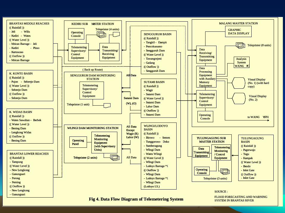
BRANTAS MIDDLE REACHES(( Rainfall ))- Jeli - Wilis- Kediri - Wates(( Water Level ))- Mrican Barrage - Jeli- Kediri - Ploso- Kertosono(( Outflow ))- Mrican Barrage
BRANTAS LOWER REACHES(( Rainfall ))- Tampung(( Water Level ))- New Lengkong- Gunungsari- Porong- Perning(( Outflow ))- New Lengkong- Gunungsari
K. KONTO BASIN(( Rainfall ))- Pujon - Selorejo Dam(( Water Level ))- Selorejo Dam(( Outflow ))- Selorejo Dam
K. WIDAS BASIN(( Rainfall ))- Wates Sawahan - Berbek(( Water Level ))- Bening Dam- Lengkong Widas(( Outflow ))- Bening Dam
KEDIRI SUB- MASTER STATION
Operating Console
Telemetering Supervisory/Control Equipment
DataTransmitting/ReceivingEquipment
Teleprinter (4 units)
SENGGURUH DAM MONITORING STATION
Telemetering Supervisory/Control Equipment
Teleprinter (1 unit)
SENGGURUH BASIN(( Rainfall ))- Tangkil - Dampit- Poncokusumo- Sengguruh Dam(( Water Level ))- Tawangrejeni- Gadang(( Outflow ))- Sengguruh Dam
SUTAMI BASIN(( Rainfall ))- Wagir- Sutami Dam(( Water Level ))- Sutami Dam- Lahor Dam(( Outflow ))- Sutami Dam
WLINGI/LODOYO BASIN(( Rainfall ))- Birowo - Semen- Tunggorono - Doko- Sumberagung- Wlingi Dam- Wates Wlingi(( Water Level ))- Wlingi Dam- Lodoyo Barrage *1(( Outflow ))- Wlingi Dam- Lodoyo Barrage *1- Wlingi Dam(Lodoyo I.S.)
GRAPHIC DATA DISPLAY
MALANG MASTER STATION
DataReceiving/TransmittingEquipment
DataProcessingEquipmentwith Auxilary Memory Equipment
Telemetering Supervisory/Control Equipment
Operating Console
Analysis System
WANG- PC
Teleprinter (3 units)
TULUNGAGUNG BASIN(( Rainfall ))- Pagerwojo- Tugu- Kampak(( Water Level ))- Bendo- Inlet Gate(( Outflow ))- Inlet Gate
SOURCE :
FLOOD FORECASTING AND WARNING SYSTEM IN BRANTAS RIVERFig 4. Data Flow Diagram of Telemetering System
Teleprinter (8 units)
Visual Display (No. 1) (with hard copy)
Visual Display (No. 2)
to WANG- VS701
All Data
( Back up Route)
Sutami Dam
(W), (O)
All Data
All Data Except Wagir (R) Lahor (W)
WLINGI DAM MONITORING STATION
Telemetering Monitoring Equipment(with Supervisory Units)
Teleprinter (2 units)
Operating Panel
TULUNGAGUNG SUB-MASTER STATION
Telemetering Monitoring / Control Equipment
DataTransmittingEquipment
Operating Console
BRANTAS MIDDLE REACHES(( Rainfall ))- Jeli - Wilis- Kediri - Wates(( Water Level ))- Mrican Barrage - Jeli- Kediri - Ploso- Kertosono(( Outflow ))- Mrican Barrage
BRANTAS LOWER REACHES(( Rainfall ))- Tampung(( Water Level ))- New Lengkong- Gunungsari- Porong- Perning(( Outflow ))- New Lengkong- Gunungsari
K. KONTO BASIN(( Rainfall ))- Pujon - Selorejo Dam(( Water Level ))- Selorejo Dam(( Outflow ))- Selorejo Dam
K. WIDAS BASIN(( Rainfall ))- Wates Sawahan - Berbek(( Water Level ))- Bening Dam- Lengkong Widas(( Outflow ))- Bening Dam
KEDIRI SUB- MASTER STATION
Operating Console
Telemetering Supervisory/Control Equipment
DataTransmitting/ReceivingEquipment
Teleprinter (4 units)
SENGGURUH DAM MONITORING STATION
Telemetering Supervisory/Control Equipment
Teleprinter (1 unit)
SENGGURUH BASIN(( Rainfall ))- Tangkil - Dampit- Poncokusumo- Sengguruh Dam(( Water Level ))- Tawangrejeni- Gadang(( Outflow ))- Sengguruh Dam
SUTAMI BASIN(( Rainfall ))- Wagir- Sutami Dam(( Water Level ))- Sutami Dam- Lahor Dam(( Outflow ))- Sutami Dam
WLINGI/LODOYO BASIN(( Rainfall ))- Birowo - Semen- Tunggorono - Doko- Sumberagung- Wlingi Dam- Wates Wlingi(( Water Level ))- Wlingi Dam- Lodoyo Barrage *1(( Outflow ))- Wlingi Dam- Lodoyo Barrage *1- Wlingi Dam(Lodoyo I.S.)
GRAPHIC DATA DISPLAY
MALANG MASTER STATION
DataReceiving/TransmittingEquipment
DataProcessingEquipmentwith Auxilary Memory Equipment
Telemetering Supervisory/Control Equipment
Operating Console
Analysis System
WANG- PC
Teleprinter (3 units)
TULUNGAGUNG BASIN(( Rainfall ))- Pagerwojo- Tugu- Kampak(( Water Level ))- Bendo- Inlet Gate(( Outflow ))- Inlet Gate
SOURCE :
FLOOD FORECASTING AND WARNING SYSTEM IN BRANTAS RIVERFig 4. Data Flow Diagram of Telemetering System
Teleprinter (8 units)
Visual Display (No. 1) (with hard copy)
Visual Display (No. 2)
to WANG- VS701
All Data
( Back up Route)
Sutami Dam
(W), (O)
All Data
Sutami Dam
(W), (O)
All Data
All Data Except Wagir (R) Lahor (W)
All Data Except Wagir (R) Lahor (W)
WLINGI DAM MONITORING STATION
Telemetering Monitoring Equipment(with Supervisory Units)
Teleprinter (2 units)
Operating Panel
WLINGI DAM MONITORING STATION
Telemetering Monitoring Equipment(with Supervisory Units)
Teleprinter (2 units)
Operating Panel
TULUNGAGUNG SUB-MASTER STATION
Telemetering Monitoring / Control Equipment
DataTransmittingEquipment
Operating Console
TULUNGAGUNG SUB-MASTER STATION
Telemetering Monitoring / Control Equipment
DataTransmittingEquipment
Operating Console
1515
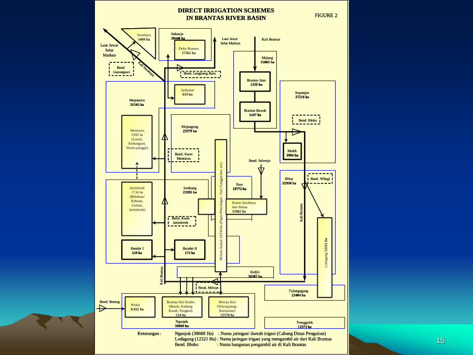
Nganjuk38668 ha
Kepanjen27216 ha
Bend. Lengkong Baru
Surabaya1469 ha
Sidoarjo28440 ha
Delta Brantas27362 ha
Brantas Atas1239 ha
Kali Brantas
Brantas Bawah1407 ha
Jatikulon619 ha
Mojoagung23579 ha
Bend. KaretMenturus
Menturus3392 ha(Losari,
Kedungsari,Wates-pinggir)
Molek3984 ha
Jombang23595 ha
Bend. KaretJatimlerek
Bunder II175 ha
Jatimlerek1716 ha
(Bebekan/Keboan,Gottan,
Jatimlerek)
Bunder I159 ha
Kediri30287 ha
Brantas Kiri Kediri(Besuk, KedungKundi, Pengkol)
534 ha
Mrican Kiri(Warujayeng-
Kertosono)12570 ha
Tulungagung23404 ha
Trenggalek12373 ha
Loda
gung
1232
1 ha
Bend. WlingiBlitar32950 ha
Kal
i Bra
ntas
Bend. Blobo
Mric
an K
anan
1633
4 ha
(Pap
ar-P
eter
onga
n,Tu
ri-Tu
nggo
rono
, etc
)
Bend. Mrican
Kal
i Bra
n ta s
Pare19772 ha
Mojokerto31545 ha
Kali Surabaya
Bend.Gunungsari
Laut Jawa/Selat
Madura
Laut Jawa/Selat Madura
Malang15801 ha
DIRECT IRRIGATION SCHEMES IN BRANTAS RIVER BASIN
Keterangan : Nganjuk (38668 Ha) : Nama jaringan/ daerah irigasi (Cabang Dinas Pengairan)Lodagung (12321 Ha) : Nama jaringan irigasi yang mengambil air dari Kali BrantasBend. Blobo : Nama bangunan pengambil air di Kali Brantas
Widas8.832 ha
Bend. Selorejo
Bend. Bening
Surabaya1469 ha
Konto Surabayadan Siman31882 ha
FIGURE 2
1616
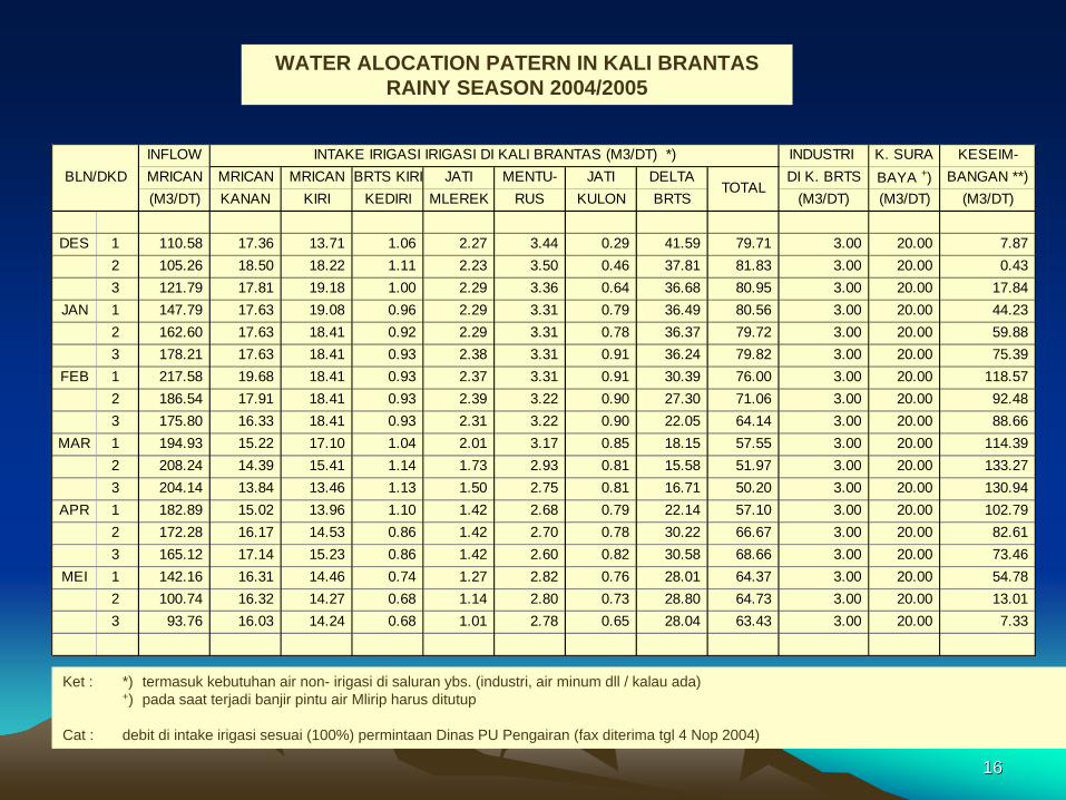
INFLOW INDUSTRI K. SURA KESEIM-MRICAN MRICAN MRICAN BRTS KIRI JATI MENTU- JATI DELTA DI K. BRTS BAYA +) BANGAN **)(M3/DT) KANAN KIRI KEDIRI MLEREK RUS KULON BRTS (M3/DT) (M3/DT) (M3/DT)
DES 1 110.58 17.36 13.71 1.06 2.27 3.44 0.29 41.59 79.71 3.00 20.00 7.87 2 105.26 18.50 18.22 1.11 2.23 3.50 0.46 37.81 81.83 3.00 20.00 0.43 3 121.79 17.81 19.18 1.00 2.29 3.36 0.64 36.68 80.95 3.00 20.00 17.84
JAN 1 147.79 17.63 19.08 0.96 2.29 3.31 0.79 36.49 80.56 3.00 20.00 44.23 2 162.60 17.63 18.41 0.92 2.29 3.31 0.78 36.37 79.72 3.00 20.00 59.88 3 178.21 17.63 18.41 0.93 2.38 3.31 0.91 36.24 79.82 3.00 20.00 75.39
FEB 1 217.58 19.68 18.41 0.93 2.37 3.31 0.91 30.39 76.00 3.00 20.00 118.57 2 186.54 17.91 18.41 0.93 2.39 3.22 0.90 27.30 71.06 3.00 20.00 92.48 3 175.80 16.33 18.41 0.93 2.31 3.22 0.90 22.05 64.14 3.00 20.00 88.66
MAR 1 194.93 15.22 17.10 1.04 2.01 3.17 0.85 18.15 57.55 3.00 20.00 114.39 2 208.24 14.39 15.41 1.14 1.73 2.93 0.81 15.58 51.97 3.00 20.00 133.27 3 204.14 13.84 13.46 1.13 1.50 2.75 0.81 16.71 50.20 3.00 20.00 130.94
APR 1 182.89 15.02 13.96 1.10 1.42 2.68 0.79 22.14 57.10 3.00 20.00 102.79 2 172.28 16.17 14.53 0.86 1.42 2.70 0.78 30.22 66.67 3.00 20.00 82.61 3 165.12 17.14 15.23 0.86 1.42 2.60 0.82 30.58 68.66 3.00 20.00 73.46
MEI 1 142.16 16.31 14.46 0.74 1.27 2.82 0.76 28.01 64.37 3.00 20.00 54.78 2 100.74 16.32 14.27 0.68 1.14 2.80 0.73 28.80 64.73 3.00 20.00 13.01 3 93.76 16.03 14.24 0.68 1.01 2.78 0.65 28.04 63.43 3.00 20.00 7.33
BLN/DKDINTAKE IRIGASI IRIGASI DI KALI BRANTAS (M3/DT) *)
TOTAL
WATER ALOCATION PATERN IN KALI BRANTASRAINY SEASON 2004/2005
Ket : *) termasuk kebutuhan air non- irigasi di saluran ybs. (industri, air minum dll / kalau ada)+) pada saat terjadi banjir pintu air Mlirip harus ditutup
Cat : debit di intake irigasi sesuai (100%) permintaan Dinas PU Pengairan (fax diterima tgl 4 Nop 2004)
1717
WATER ALOCATION PATTERNDRY SEASON 2005
INFLOW INDUSTRI K. SURA KESEIM-MRICAN MRICAN MRICAN BRTS KIRI JATI MENTU- JATI DELTA DI K. BRTS BAYA +) BANGAN **)(M3/DT) KANAN KIRI KEDIRI MLEREK RUS KULON BRTS (M3/DT) (M3/DT) (M3/DT)
JUN 1 75.73 16.26 13.92 0.54 1.25 1.51 0.67 17.67 51.82 3.00 20.00 0.912 72.38 15.25 13.92 0.55 0.97 1.45 0.67 15.88 48.69 3.00 20.00 0.693 64.32 13.48 13.15 0.54 0.82 1.50 0.67 10.91 41.07 3.00 20.00 0.25
JUL 1 60.62 12.21 10.47 0.53 0.67 1.63 0.67 11.27 37.46 3.00 20.00 0.172 59.70 11.13 9.07 0.44 0.67 2.00 0.67 12.36 36.35 3.00 20.00 0.353 53.79 9.44 6.75 0.30 0.67 2.05 0.67 10.26 30.15 3.00 20.00 0.65
AGS 1 53.62 10.64 6.33 0.26 0.67 1.79 0.52 10.29 30.50 3.00 20.00 0.122 53.95 9.45 6.33 0.26 0.67 1.82 0.28 9.74 28.55 3.00 20.00 2.403 50.99 8.65 6.33 0.26 0.68 1.89 0.17 9.09 27.08 3.00 20.00 0.91
SEP 1 50.82 8.51 6.48 0.26 0.50 1.92 0.18 9.86 27.70 3.00 20.00 0.112 51.32 8.51 6.58 0.26 0.50 1.91 0.18 9.51 27.45 3.00 20.00 0.873 53.63 8.51 6.65 0.27 0.50 1.80 0.18 11.80 29.71 3.00 20.00 0.92
OKT 1 55.09 9.40 6.80 0.45 0.84 1.79 0.20 11.73 31.21 3.00 20.00 0.882 56.08 9.49 6.91 0.47 1.07 1.91 0.34 10.80 30.98 3.00 20.00 2.103 60.24 10.81 6.14 0.67 1.58 1.84 0.62 10.94 32.60 3.00 20.00 4.63
NOP 1 66.33 12.50 7.40 0.61 1.91 2.33 0.64 14.68 40.08 3.00 20.00 3.252 77.72 16.80 8.04 0.64 2.17 2.63 0.69 19.89 50.86 3.00 20.00 3.853 99.23 16.14 10.30 0.70 2.57 2.92 0.68 38.92 72.23 3.00 20.00 4.00
BLN/DKDINTAKE IRIGASI IRIGASI DI KALI BRANTAS (M3/DT) *)
TOTAL
18184
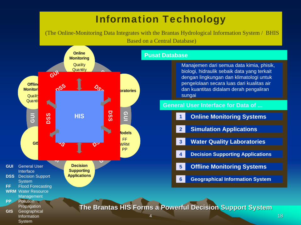
Manajemen dari semua data kimia, phisik, biologi, hidraulik sebaik data yang terkait dengan lingkungan dan klimatologi untuk pengelolaan secara luas dari kualitas air dan kuantitas didalam derah pengaliran sungai
Pusat Database
Online Monitoring Systems
Simulation Applications
1
2
General User Interface for Data of ...
Water Quality Laboratories 3
Decision Supporting Applications4
Offline Monitoring Systems5
Geographical Information System6
GIS
Laboratories
ModelsFF
WRMPP
GUI
GUI
GUI
Online Monitoring
QualityQuantity
DecisionSupporting
Applications
Offline Monitoring
QualityQuantity
DSS
DSS
DSS
DSS
DSS
DSS
GUI
GU
I GU
IHIS
GIS
Laboratories
ModelsFF
WRMPP
GUI
GUI
GUI
Online Monitoring
QualityQuantity
DecisionSupporting
Applications
Offline Monitoring
QualityQuantity
DSS
DSS
DSS
DSS
DSS
DSS
GUI
GU
I GU
IHIS
GUI General User Interface
DSS Decision Support System
FF Flood Forecasting WRM Water Resource
ManagementPP Pollution
Propagation GIS Geographical
Information System
The Brantas HIS Forms a Powerful Decision Support SystemThe Brantas HIS Forms a Powerful Decision Support System
Information Technology(The Online-Monitoring Data Integrates with the Brantas Hydrological Information System / BHIS
Based on a Central Database)
1919
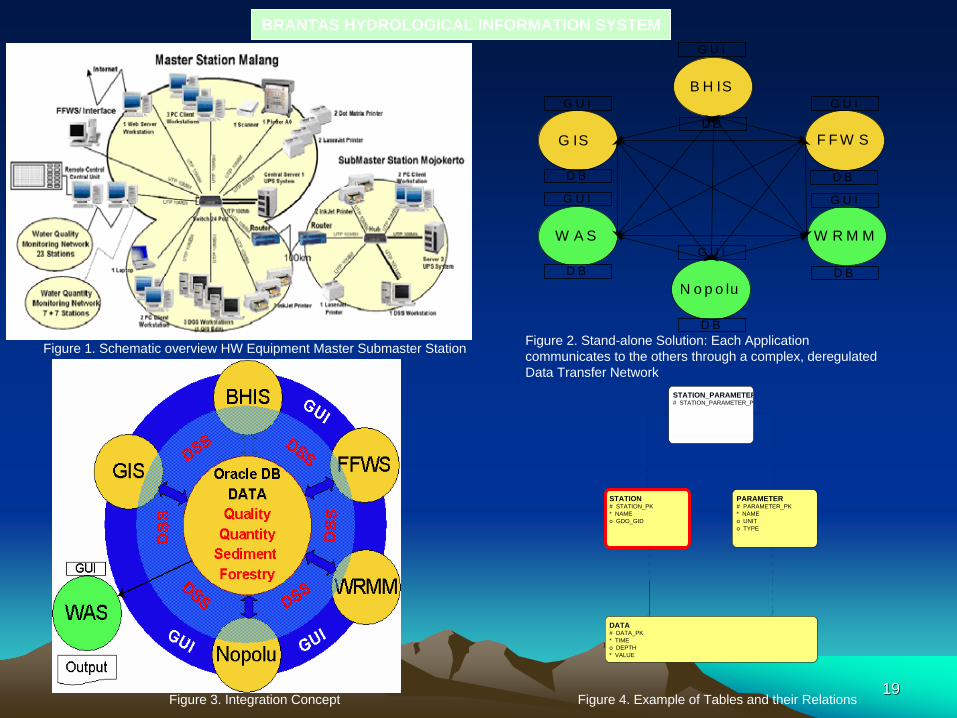
BRANTAS HYDROLOGICAL INFORMATION SYSTEM
Figure 1. Schematic overview HW Equipment Master Submaster Station
G IS
W A S
F F W S
W R M M
N o p o lu
B H IS
G U I
G U I
G U I
G U I
G U I
G U I
D B
D B
D B
D B
D B
D B
Figure 2. Stand-alone Solution: Each Application communicates to the others through a complex, deregulated Data Transfer Network
Figure 3. Integration Concept
DATA# DATA_PK* TIMEo DEPTH* VALUE
PARAMETER# PARAMETER_PK* NAMEo UNITo TYPE
STATION# STATION_PK* NAMEo GDO_GID
STATION_PARAMETER# STATION_PARAMETER_P
Figure 4. Example of Tables and their Relations
2020
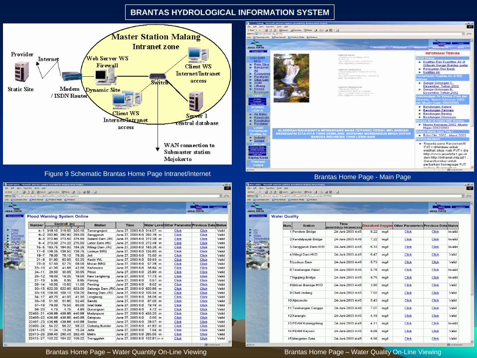
BRANTAS HYDROLOGICAL INFORMATION SYSTEM
Figure 9 Schematic Brantas Home Page Intranet/Internet Brantas Home Page - Main Page
Brantas Home Page – Water Quality On-Line ViewingBrantas Home Page – Water Quantity On-Line Viewing
2121
• Present water uses in the Brantas River and its main tributaries
i.e. for electricity generation, irrigation, brackish water fishponds,
domestic water supply, industrial water supply and river
maintenance flow will cause potential conflict among water users
due to water shortage in the basin.
• To avoid conflict among water users in the Brantas River basin, a
provincial Water Resources Management Committees (Panitia Tata Pengaturan Air/PTPA) was established based on the East
Java Governor’s Decree No. 59 of 1994. Until now, this
committee has successfully become an essential coordination
among stakeholders in allocating water in the basin, but should
be improved its membership and advance its capacity in the
future.
ConclusionConclusion

2222
Thank you for attention