Embed Size (px)
Citation preview

1
WATER FLOWAND
SEDIMENT TRANSPORTIN THE LOWER DANUBE RIVERROMANIAN RETROSPECTIVE and PERSPECTIVE
Dr Dan G Batuca
National Institute of Hydrology and Water Management, Bucharest
3rd SedNet Conference 25 – 26 November 2004, VeniceThe future of sediment management in Europe

2
3rd SedNet Conference 25 – 26 November 2004, Venice
Danube River Basin in Europe
� Second largest river basin in Europe:� catchment of 801,463 km2
� shared by 18 countries

3
3rd SedNet Conference 25 – 26 November 2004, Venice
Danube RiverThe “ Great Blue Diagonal ” of Europe
� Second longest river in Europe� 2857km-long in 9 riparian
countries � Flows through 4 capital cities
• Vienna • Bratislava • Belgrade • Budapest
and other major cities in the region

4
3rd SedNet Conference 25 – 26 November 2004, Venice
Danube River at Vienna

5
3rd SedNet Conference 25 – 26 November 2004, Venice
Danube River at Budapest

6
3rd SedNet Conference 25 – 26 November 2004, Venice
Danube River Network Major tributaries
Flow (m3/s)Length (km)Tributary
110950Prut
240559Siret
71350Arges
174615Olt
86339Jiu
47285Yantra
54368Isker
232430Morava
1564861Sava
794966Tisza
577893Drava
110352Morava
135514Inn

7
3rd SedNet Conference 25 – 26 November 2004, Venice
Upper Danube Middle Danube Lower Danube

8
IMPORTANCE OF THE LOWER DANUBE RIVER
� Major international watercourse
� Multipurpose used by riparian countries
� power generation
� fluvial navigation
� water supply
• agriculture water(irrigation)
• domestic water (drinking)
• industrial water
� Fishing
� Tourism and recreation
3rd SedNet Conference 25 – 26 November 2004, Venice

9
IMPORTANCE OF THE LOWER DANUBE RIVER
man-made structures and works� Iron Gates 1 and 2 great systems for
� power generation� fluvial navigation� flood attenuation
� Great rail-road bridges at Giurgiu- Russe and Calafat(future)
� Embankments for flood protection� Intakes for water supply � Sand mining
3rd SedNet Conference 25 – 26 November 2004, Venice

10
3rd SedNet Conference 25 – 26 November 2004, Venice
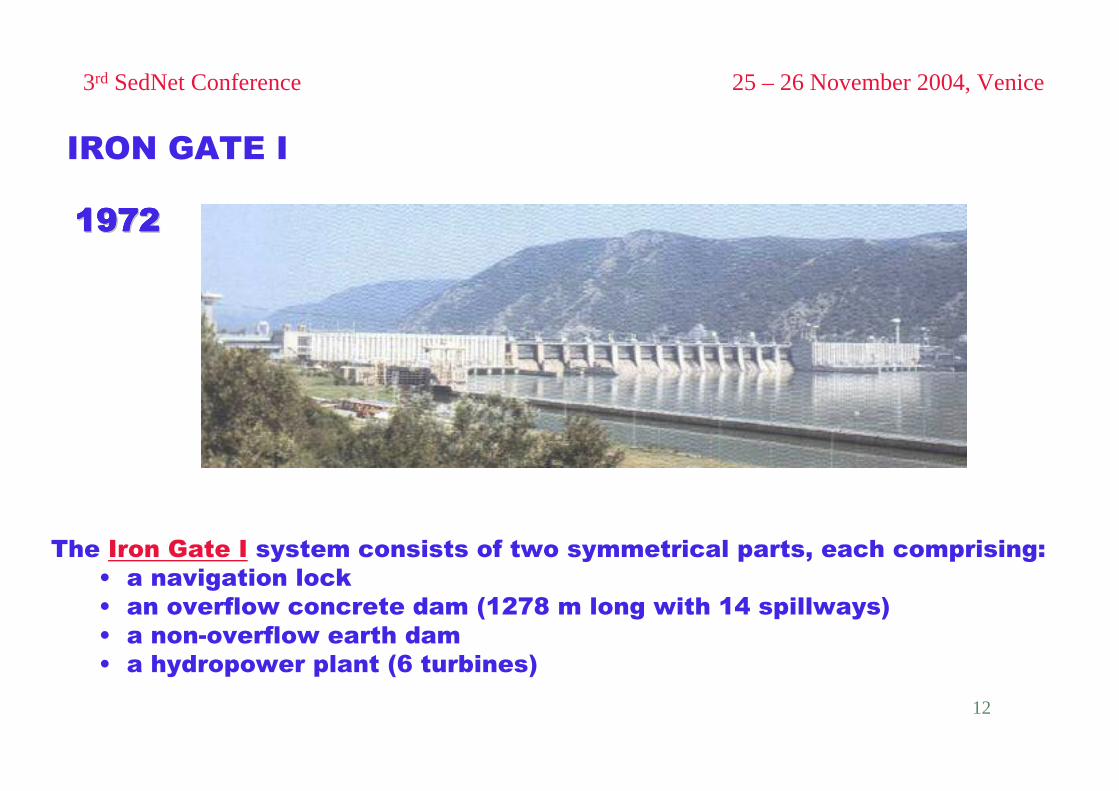
IRON GATES I (1972) and II (1985) – Romania and Yugoslavia

11
3rd SedNet Conference 25 – 26 November 2004, Venice
Average reservoir volume:3.5 x 10⁹ m3
IRON GATE IIIRON GATE IIIRON GATE IIIRON GATE IIIRON GATE IIIRON GATE IIIRON GATE IIIRON GATE IIRESERVOIRRESERVOIRRESERVOIRRESERVOIRRESERVOIRRESERVOIRRESERVOIRRESERVOIR:
Average reservoir volume:0.8 x 10⁹ m3
IRON GATE IIRON GATE IIRON GATE IIRON GATE IIRON GATE IIRON GATE IIRON GATE IIRON GATE IRESERVOIRRESERVOIRRESERVOIRRESERVOIRRESERVOIRRESERVOIRRESERVOIRRESERVOIR:
12
3rd SedNet Conference 25 – 26 November 2004, Venice
19721972197219721972197219721972
The Iron Gate I system consists of two symmetrical parts, each comprising:• a navigation lock• an overflow concrete dam (1278 m long with 14 spillways)• a non-overflow earth dam• a hydropower plant (6 turbines)
IRON GATE I

13
3rd SedNet Conference 25 – 26 November 2004, Venice
19851985198519851985198519851985
The Iron Gate II system consists of two dams:• an overflow concrete dam on the main Danube channel (1003 m long)• an overflow concrete dam on the Gogos branch• a hydropower plant (20 turbines)• a navigation lock
IRON GATE II

14
ROMANIANROMANIANRETROSPECTIVERETROSPECTIVE

15
SCIENTIFIC & PRACTICAL INVESTIGATIONin the Lower Danube River – ROMANIAN RIVER REACH
OBJECTIVES:•• Evaluation of hydrological & hydraulic regime:Evaluation of hydrological & hydraulic regime:
•• water flow regimewater flow regime•• sediment transport regimesediment transport regime
•• Evaluation of river processes & morphological changes:Evaluation of river processes & morphological changes:•• thalwegthalweg changeschanges•• crosscross--sectional changessectional changes
•• Determination of water & sediment qualityDetermination of water & sediment quality
MEANS:• Field data
• collected at permanent hydrometric stations• during periodic field campaigns
• Laboratory data
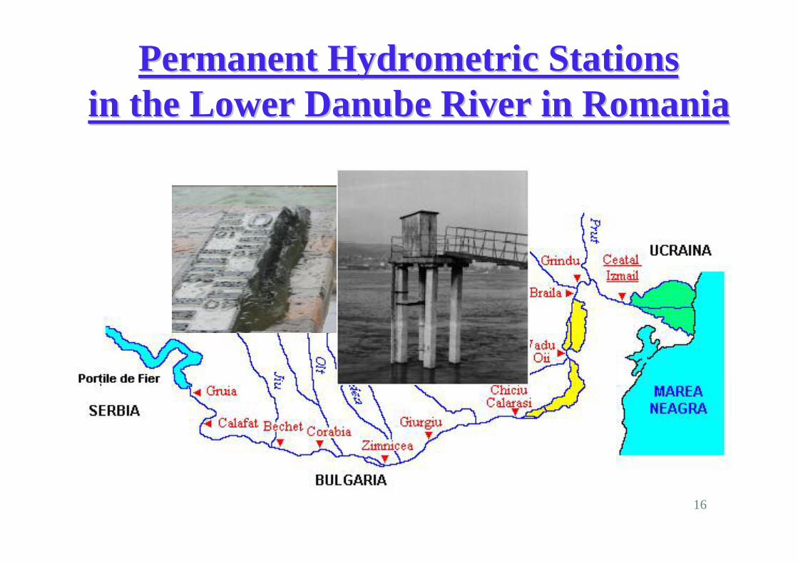
16
Permanent Hydrometric Stations Permanent Hydrometric Stations in the Lower Danube River in Romaniain the Lower Danube River in Romania

17
Periodical Field Measurement Campaigns Periodical Field Measurement Campaigns along the Lower Danube River in Romaniaalong the Lower Danube River in Romania

18
Type of Data Collected in the Field
� Physical properties of water and sediment
� Hydraulic flow parameters • Water level and discharge
• Flow velocity and depth
� Sediment (bottom & suspended) data• Sediment discharge and turbidity
• Sediment size distribution (granulometry)
� Bathymetric data• River geometry (long & cross profiles)

19
WATER – SEDIMENT REGIME(history – based on field information, data)
� Up to year 1965 – “NATURAL REGIME”(UNDISTURBED)
� From 1965 to 1985 – “TRANSIENT REGIME”Great changes in time due to: * natural causes (climate) * anthropic works & activities
� From 1985 to present – “ACTUAL REGIME”
(DISTURBED)

20
Water flow regime – Danube River

21
Water flow regime – Tributaries

22
Discharge Rating Curves
ChiciuChiciu -- CalarasiCalarasiCorabiaCorabia

23
Sediment transport regime – Danube River

24
Sediment transport regime – Tributaries

25
Sediment transport equations

26
Natural – Actual Sediment Transport Regimes

27
ACTUAL WATER – SEDIMENT REGIME

28
Morphological River Bed Changesthalweg degradation & aggradation

29
Morphological River Bank Changeshigh bank erosion (terrace)

30
Morphological River Bank Changesflat bank erosion (flood area)

31
Morphological Changesalluvial island formation

32
Morphological Changesalluvial bar formation - dredging

33
ROMANIANROMANIANPERSPECTIVEPERSPECTIVE
viaviaINTERNATIONALINTERNATIONAL
PROJECTSPROJECTS

34
PharePhare -- CROSSCROSS--BORDER COOPERATION BORDER COOPERATION Romania Romania -- BulgariaBulgaria
MONDAN PROJECTMONDAN PROJECT

35
MONDAN PROJECTMONDAN PROJECT
Integrated crossIntegrated cross--border monitoring system for border monitoring system for the Lower Danube Riverthe Lower Danube River
Proposed by
Romanian Ministry of Environment and Water Managementand
Bulgarian Ministry of Transport and Communication

36
MONDAN PROJECTMONDAN PROJECT
� Project type: Bilateral – Danube River from Timok to Calarasi-Silistra(Improvement of infrastructure)
� Framework: EU – PhareCross Border Cooperation Romania – Bulgaria
� Authority: Ministry of Environment and Water Management – RO Ministry of Transport and Communications – BG
� Contribution: ICPDR ViennaDanube Commission Budapest

37
MONDAN PROJECTMONDAN PROJECT
� Project Type: Structural – improvement of monitoring systems(hydrometric network)
� Project Duration: 3 years (2005-2007) in 3 phases: * Phase 1 – 2005* Phase 2 – 2006* Phase 3 – 2007
� Estimated Cost: 6,8 MEuro

38
OVERALL OBJECTIVESOVERALL OBJECTIVES
� To promote co-operation between Romania and Bulgaria in the field of:
�Environmental protection
�Fluvial navigation and transportation
� To join and harmonize the hydrologic and hydrometric experience in both countries with current international requirements, including the WFD
� To improve the existing monitoring systems in the Lower Danube River
� To develop a reliable working tool for water management policy-makers, decision takers and investors in the Lower Danube River

39
PROJECT GOALS (1)PROJECT GOALS (1)� Development of an advanced integrated monitoring system for
the Lower Danube River, along the Romanian – Bulgarian reach
� Modernization of existing surveillance and hydrometric systems, including:� Modernization of 14 hydrometric stations, from which
– 8 in Romania– 6 in Bulgaria
� Development of 3 new stations in Bulgaria� Collection of field data, including:
– hydrological data– sedimentological data– morphological data– water-sediment quality data
� Acquisition of 2 new specialized vessels for hydrometry, survey and research

40
Romanian – Bulgarian Danube River Reach

41
PROJECT GOALS (2)PROJECT GOALS (2)
� Implementation of a Cross-Border Danubian Computer Model (CBDM) for the Lower Danube River, with advanced modules for:
• Water flow dynamics• Sediment transport• Morphological river changes
aiming to provide hydrologic and morphologic warning and forecasts during:
• Low flows• High flows• Exceptional events (floods)• Accidental pollution
� Implementation of advanced technologies and techniques:• Digital cartography• Geographical Information System (GIS)• GPS and DGPS

42
MONDANPROJECT
COMPUTATIONALSTRATEGY

43
PROJECT SEDAN
S E D A NS E D A N
IHP IHP –– Regional Hydrological CoRegional Hydrological Co--operation operation ProgrammeProgrammeof the Danube Countriesof the Danube Countries

44
SEDAN PROJECTSEDAN PROJECT
Modeling of Modeling of erosion, transport and sedimentation processeserosion, transport and sedimentation processesin the Danube River and its major tributariesin the Danube River and its major tributaries
Proposed by
IHP - Romanian National Committeewithin
National Institute for Hydrology and Water Management, Bucharest

45
SEDAN PROJECTSEDAN PROJECT
� Project type: Regional – Danube River Basin
� Framework: IHP UNESCORegional Hydrological Co-operation Program of the Danube Countries
� Authority: IHP-UNESCO ParisUVO ROSTE Venice
� Contribution: ICPDR ViennaIAD ViennaDanube Commission Budapest

46
SEDAN PROJECTSEDAN PROJECT
� Coordinating country: Romania
� Cooperating countries: Danube countries(IHP National Committees)
� Project Duration: 5 years (2005-2009) in 3 phases: * Phase 1 – 1year (2005)* Phase 1 – 2 years (2005-2006)* Phase 2 – 3 years (2007-2009)
� Estimated cost: 2,0 MEuro

47
SEDAN PROJECT SEDAN PROJECT –– Background Background
Previous actions:
�2003 – Sofia and Venice
�2004 – Bucharest, Brno, Paris and Vienna
Next actions:
�2005 – Vienna, Passau and Belgrade

48
SEDAN PROJECTSEDAN PROJECT
Contribution of the IHP Danube Countries to ISIInternational Sedimentation Initiative
GEST ProjectGEST ProjectGlobal Evaluation
of Sediment Transport
SEDAN ProjectSEDAN Project
Case Study (Pilot-project) for Europe
(Danube River Basin)

49
OVERALL OBJECTIVESOVERALL OBJECTIVES� To promote co-operation between Danube countries
� To join and harmonize the Danube countries experience
� To improve the actual level of knowledge in the field of river modelling(flow and sediment)
Particular view on erosion, transport andsedimentation processes in the Danube River Basin
� To develop a reliable working tool for water management policy-makers, decision-takers and investors in the Danube River Basin
� To contribute to International Sedimentation Initiative (ISI – GEST Project)

50
PROJECT GOALS (1)PROJECT GOALS (1)
To develop and use a Sediment Databank (SEDAT) for theDanube River and its major tributaries, including:
– hydrological data– sedimentological data– morphological data– quality data
Type of data & information:– historical data– existing data (from 1985 to 2000 or more)– new collected data
!!! SEDAT - freely accessible for Danube countries !!!

51
SEDIMENT DATABANK - SEDAT

52
PROJECT GOALS (2)PROJECT GOALS (2)
To establish the Current Budget and Balance of Sediment (SEDBUD & SEDBAL)
In the Danube River and its major tributaries:
» Suspended load» Bed-load» Total load » Sediment granulometry
!!! SEDBUD & SEDBAL - freely accessible for Danube countries !!!

53
PROJECT GOALS (3)PROJECT GOALS (3)
To develop and use a Danubian Computer Model SEDMODwith advanced modules for:
* water flow dynamics, * sediment erosion and transport,* morphological river changes,
aiming to provide:* warnings * improved forecast procedures * calculation-simulation procedures
applicable to the Danube River and its major tributaries.

54
DANUBIAN COMPUTER MODEL DANUBIAN COMPUTER MODEL -- SEDMODSEDMOD

55
PROJECT GOALS (4)PROJECT GOALS (4)
To develop and use an Information System (SEDIS) forsedimentation-morphological status of the Danube Riverand its major tributaries,
Dedicated web-site for wide dissemination for authorities,public and media:
• Information• Data• Warnings

56
EXPECTED PRACTICAL RESULTSEXPECTED PRACTICAL RESULTS
♦ Project Implementation & Coordination Unit PICU
♦ Technical reports and scientific papers
♦ Training programmes for specialists from Danube
countries
♦ Workshops and meetings

57
PROJECT OUTPUTSPROJECT OUTPUTS

58
FINANCING & BANKABILITYFINANCING & BANKABILITY
� Estimated total amount: 2.0 MEuro� Sharing between Danube countries: 0.8 MEuro
from which:� contribution of Romania: 0.3 MEuro� contribution of other countries: 0.5 MEuro
� Needs for external support: 1.2 MEuro

59