Embed Size (px)
Citation preview

Water-Holding Characteristics of Metasedimentary Rock in Selected Forest Ecosystemsin Southwestern Oregon
Maciej A. Zwieniecki* and Michael Newton
ABSTRACTOn sites characterized by shallow soil in semiarid climates, lack of
bedrock description may lead to underestimates of total storage capac-ity of water available for plants, and therefore of potential site produc-tivity. Sample rocks from southwestern Oregon soil-rock profiles exca-vated beneath typical forest plant communities were examined forpore volume distribution by means of mercury intrusion porosimetryand oversolution equilibrium. Four ranges of pore size were distin-guished: gravitational water, available water content (AWC), slowlyavailable water (SAW), and nonavailable water. Pore volume for AWCand SAW was associated with bulk density and in low density rock,was 20% of volume. Results suggest that metasedimentary rock hasthe potential to be a major reservoir of plant available water insemiarid climates.
THE LACK OF DESCRIPTION of bedrock in soil surveysmay lead to underestimation of AWC and therefore
of site productivity, if the rock should have significantwater-storage capacity. Indeed, Joffre and Rambal (1993)found that evapotranspiration computed from the waterbalance equation was low when compared with measuredtranspiration, a result associated with underestimationof root extension into the soil-rock profile. Plants ofmany families are able to penetrate fractured rock layers(Cannon, 1911; Stone and Kalisz, 1991). Some of theEricaceae family develop the considerable root lengthdensity of 0.3 cm cm"3 rock and locate one-third oftheir total root length in the bedrock (Zwieniecki andNewton, 1994). Root morphology suggests that rootsfound in bedrock are acquiring water and possibly nutri-ents from the rock (Zwieniecki and Newton, 1995).
Analysis of water depletion from the soil-rock profileunder plant cover shows that >200 mm of transpiredwater can come from the bedrock (Shachori et al., 1967;Detau, 1987; Zwieniecki and Newton, 1996). This watermay constitute more than 50% of all water use by theplants during the growing season in such different ecosys-tems as Israeli maqui (Shachori et al., 1967), Frenchvineyards (Detau, 1987), and southern Oregon chaparrals(M. Zwieniecki and M. Newton, 1996, unpublisheddata). Recent reports evaluate AWC at <1% and >12%,respectively, for unweathered and highly weathered gran-ite rock (Jones and Graham, 1993). Montagne et al.(1992) report that some siltstone has more than 15%AWC. Capacity varies with the bulk density of the rock,and in sedimentary rock, it can be from 8 to 22%(Kummerow, 1981; Wang et al., 1995).
The objective of this study was to determine water-holding characteristics of sedimentary rock relative to
Department of Forest Science, Oregon State Univ., Corvallis, OR 97331.This is Paper 3076 of the Forest Research Lab., Oregon State Univ.,Corvallis. Received 30 March 1995. "Corresponding author (zwieniem®ccmail.orst.edu).
Published in Soil Sci. Soc. Am. J. 60:1578-1582 (1996).
its bulk density. Four ranges of water matrix potentialwere of interest: (i) gravitational water, which plays amajor role in buffering surface water flow, temporarilyheld in the range from 0 to -10 J kg'1; (ii) AWC,which is crucial to plant life, nominally ranging from-10 to -1500 J kg~'; (iii) SAW, which may supportsome sclerophyllous woody plants that can transpirewater with leaf water potential as low as —10000 Jkg"1; and (iv) NAW (hygroscopic), which is unavailableto plants but removable by oven drying. In this study,-4000 J kg~" was designated for NAW after measure-ments were made of pre-dawn water potential of sclero-phyllous shrubs at the sites of interest (Jones and Graham,1993).
METHODSRock samples were collected in two locations in southwest-
ern Oregon. Annual precipitation there ranges from 600 to1200 mm yr~ ' , 87% during the six winter months. Sites werecharacterized by 40- to 70-cm-deep gravelly loams or clayloams of the Vermisa (loamy-skeletal, mixed, mesic LithicXerochrept) and Beekman (loamy-skeletal, mixed, mesic Dys-tric Xerochrept) series, with pockets of fine loams of the Kerbyseries [loamy-skeletal, over fragmental, mixed (calcareous),frigid Ustic Torriorthents; Bureau of Land Management,1977]. Underlying rock material is slightly to moderatelyweathered sedimentary rocks of the Dothan formation andmetasedimentary rocks of the Applegate group (Peck, 1961).On one site, two profiles were located under mixed Pacificmadrone (Arbutus menziesii Pursh) and Douglas-fir [Pseu-dotsuga menziesii (Mirbel) Franco]. The site had been burnedpreviously and was occupied by regenerating madrone sproutclumps and planted Douglas-fir (90 and 10% basal area, respec-tively). On another site, where whiteleaf manzanita (Arctosta-phyllos viscida Parry) had been cleared mechanically andplanted with conifers, one profile was excavated under a purestand of newly germinating manzanita and one under a purestand of ponderosa pine (Pinus ponderosa Douglas ex P.&C.Lawson). All stands were 12 yr old. Detailed descriptions ofthe sites are given in Wang et al. (1995) and Pabst et al.(1990).
At the end of summer 1992, four 4-m-deep profiles of soiland rock were opened by drilling and blasting with mediumvelocity dynamite, which permitted examination of the struc-ture of the vertical 2-m-wide headwalls with minimum damage.The profiles had a 35- to 45-cm-deep soil layer on the rock,and the boundary between soil and rock was sharp). Immediatelyafter removal of the loose blasted material, three samples ofsoil or rock were collected from seven depths at 0.5-m intervals.The volume of intact soil or rock samples was from 2 to 4 dm3.Large fragments of fractured rock were used. Subsamples of« 300- to 400-cm3 volume were sealed in plastic bags andlater used to evaluate end-of-summer water content (by dryingat 386.15 K for 72 h). In total, 100 samples were collected.
Dry rock or soil subsamples were coated with a sealant(Thompson and Formby Co. water seal, Memphis, TN) for
Abbreviations: AWC, available water content; SAW, slowly availablewater; NAW, nonavailable water.
1578

ZWIENIECKI & NEWTON: WATER-HOLDING CHARACTERISTICS OF SOUTHWESTERN OREGON ROCK 1579
determination of bulk density. The volume of the rock wasdetermined by displacement according to Archimedes' Princi-ple (Jones and Graham, 1993).
Porosity and water-holding capacity were determined bymercury intrusion porosimetry and the vapor-equilibrationmethod. Mercury intrusion porosimetry gives volumetric distri-bution of pore diameters in the range of 50 to 0.036 mm. Itwas applied on 0.5 to 1.5 g of soil or rock particles that werefirst oven dried at 386.15 K for 72 h. Samples were placedin a small, prevacuumed chamber and submerged in liquidHg; then as pressure was increased, the volume of Hg penetrat-ing the sample and the corresponding pore diameter wererecorded (AMINCO porosimeter Model 5000 psi). Water ma-trix potential was obtained by applying the capillary principleto calculated pore diameter with the assumption of 100%wetness of capillary walls and a water surface tension of 0.0728Pa m~' at 293.15 K. Calculated ranges of the water matrixpotential and the equivalent ranges of pore diameter are shownin Table 1. Density of minerals was assumed to be 2.75 gcirr3, based on the average measurement of five randomlychosen rock particles (pycnometer).
The vapor-equilibration method entails a series of six glassdesiccators in which water vapor pressure is maintained byNaCl solutions at the water potentials -500, -1000, -1500,-2000, -3000, and -4000 J kg-' as calculated for 296.15K. Three soil or rock particles (1-2 cm3) of each samplewere placed in each desiccator (total 300 samples). Duringequilibration, desiccators were kept in a thermoregulated cham-ber at a constant 296.15 K. For additional protection againsttemperature oscillation, desiccators were in a styrofoam box.Solutions were replaced every 8 to 9 wk, at which time netweight gain due to water absorption of all samples in theregulated humidity was recorded. When no changes in weightwere observed in two consecutive 8- to 9-wk periods, theequilibration process was terminated. After 12 mo, sampleswere weighed and oven dried at 383.15 K for 72 h for determi-nation of water content.
Water extractable from the rock particles by living plantswas determined by a grass bioassay. Five rock particles ofthe same sample ranging in volume from ~ 1 cm3 to ~40cm3 were placed in each of 99 small pots (200-cm3 volume).Space between the rocks was filled with coarse sand, and thepots were watered daily to near field water capacity. Grasswas allowed to grow in the pots for 4 wk. One-third of allpots were then randomly collected, and water content in therock was determined. The remaining pots were split into twoequal groups, one in which the grass was killed with glyphos-phate herbicide and one in which the grass was left alive.There was no additional watering. After 3 wk, when =50%of the untreated grass was dead from dehydration, the rocksin the remaining pots were collected and volumetric watercontent was determined for each particle. The volume ofsamples was determined from their dry weight and the formerlydetermined bulk density of each sample.
For clarity of interpretation of the observed trends in changesof volumetric water content, data were analyzed by multiple
Table 1. The ranges of water matrix potential, calculated withassumptions of 100% wetness of capillary walls and 0.0728 Pani~' water surface tension, and equivalent pore diameters.
Water availability Water matrix potential Pore diameter
Gravitational waterAvailable water contentSlowly available waterNonavailable water
-10 to 0- 1500 to - 10- 4000 to - 1500
More negative than — 4000
fan
0.097-140.036-0.097
<0.036
regression with polynomials of bulk density providing all inde-pendent variables. The results are given here in superscriptplots on the figures.
RESULTSBulk density of soil from the study sites ranged from
1.49 to 1.82 g cm"3, and bulk density of rock rangedfrom 1.97 to 2.68 g crrr3. Association of rock bulkdensity with the depth of origin was weak and variedsubstantially within layers.
Mercury intrusion porosimetry and the vapor-equilibration method gave similar patterns of pore-sizedistribution across the range of bulk densities, althoughresults calculated from mercury intrusion were slightlylower (Fig. 1). An analysis of pore sizes showed thatmore than 20% of total soil volume was in pores of theAWC range, 5% in the SAW range, and 18% in thegravitational water range when density is 1.5 g cm"3.Total pore volume decreased in proportion to the increasein soil bulk density. In rock, volume in pores of smallerdiameter increased slightly, especially within the NAWrange, which more than doubled from 3 % of the volumeat 1.5 g cm"3 (soil) to 8% at 2.1 g cm"3 (rock). Pore
MPaTotal porosity 50
40
•£I53I
30-
20
10
Soil
O-0.01 • • - - • • • -0-0.5 ---•D-1.5 ———A-4.0 ————
ROCK
40-
30-
20-
10-
0
Rock
1.4 1.6 1.8 2.0 2.2 2.4 2.6 2.8
1.4
B
1.6 1.8 2.0 2.2 2.4 2.6 2.8
Bulk Density (g/cm3)Fig. 1. Volumetric water content for different water matrix potentials
in relation to bulk density. Total porosity was calculated from bulkdensity and density of minerals. Insets show trends obtained bymultiple regression with polynominals for bulk density. (A) Resultsfrom the vapor-equilibration method; (B) results from mercuryintrusion porosimetry.

1580 SOIL SCI. SOC. AM. J., VOL. 60, SEPTEMBER-OCTOBER 1996
1.75 2.00 2.50
Bulk Density (g/cm3)Fig. 2. Space partitioning among ranges of water matrix potential,
expressed as a percentage of total pore volume, in relation to rockbulk density. AWC = available water capacity, SAW = slowlyavailable water, and NAW = nonavailable water. Results werederived from the different regression equations for data from mer-cury intrusion porosimetry (see Fig. IB).
volume in the AWC and gravitational ranges decreasedmarkedly with an increase in bulk density (Fig. 1). Above2.1 g cm~3, volumes in pores of all sizes decreasedwith increasing density. Soil and rock show well-fittingcontinuity of pore volume distribution within measuredranges.
Along with the general decline in pore volume withincreasing bulk density, the distribution changed amongthe ranges of interest. Figure 2 illustrates that as densityof soil-rock increased from 1.5 to 2.5 g cm"3, porevolume for gravitational-water decreased from 36 to 10%and volume for the AWC decreased from 44 to 22% oftotal pore volume. At 2.5 g cm"3 density, 15% of thepore volume was in the SAW range and 53% in theNAW range.
A good relationship appeared between bulk densityand AWC (R2 adj. = 0.77, P < 0.0001) and betweenbulk density and AWC plus SAW (R2 adj. = 0.80, P <0.0001). In general, AWC plus SAW is 3 to 5% higherthan AWC alone, which could contribute 12 to 21 mmof water in the 40 to 70 cm of soil found on the sitesof interest and more than 90 mm of water in the 3.5-m-deep rock layer penetrated by roots (Fig. 3).
The grass bioassay showed the volume of water in fullywatered pots to be slightly higher than the percentagerepresented by the -0.01 matrix potential line (Fig. 4).Depletion of water from rocks in pots with herbicide-treated grass reflected the evaporation process and localdiffusion or unsaturated movement. It must be acknowl-edged that an unknown quantity of transpiration occurredin the treated grass before its death terminated the pro-cess. Water content of high-density rocks under deadgrass was no different than that under living grass, butmore water was depleted from low-density rocks beneathliving grass than from beneath dead grass, reflectingwater uptake. Rock water content under living grass wasclose to the line of the AWC range obtained from thevapor-equilibration method.
DISCUSSIONPore volume of sedimentary rock in the AWC range
can be as high as 15% at low rock bulk density (1.95-2.1 g cm"3). Similar values have been obtained forother rock types: for weathered granite 11 % (Jones andGraham, 1993), for sandstone 11 % (Hanson and Blevins,1979), and for siltstone 10% (Montagne et al., 1992).The AWC volume in this study gradually decreased withincreasing rock bulk density, but metasedimentary rockin this study still showed potentially available plant water,i.e., 8% of rock volume at 2.3 g cm"3 density (SAWrange included). For 3-m-deep rock, this percentage willaccount for 240 mm of available water, which nearly
oo
"o
\JU-
25-MPa
A\Air- A n AH *« 4 c ...... 20"35-
30'
25-
20-
15-
10-
5.
0 -
r-*V1\S \J M.U 1 IU 1 .il
AWC + SAW • -0.01 to -4.0 —— 15-
. . 10-
0 n 5-
•
._ Soil RockO*"*-^ *̂***.
^x;\̂s^x.
\̂̂ x.^^-^
uipics me suii-wiuer siurage capacity, a iremenaous
40 -, —————————————————————
30-——— o Normally watered
40-5?
f • 1.6 1.8 2.0 2!2 2.4 2^6 §OD « •
°0<b . * *
o o ° J| Rock• *8 t^<l •O o Q8*«lQson ° •• rt̂ <i& .
0 80 ! * »°o.fc
I 30-oOoj
$ 20-u-c
i 10-
>
1.6 1.8 2.0 2.2 2.4 2.6 n
——— --••••• Live grass 20_— — -V Dead grass
10-
s •• .;
— — -1.5MPa
->^^
~~~~-^^^^^" "''***^^^ ^^^^
^^5 2.0
0 ° §°S0
* v v^r ° t.^•••.^V^V o
*** • ,*°
2.5
1.5 2.0 2.5Bulk Density (g/cm3)
Fig. 3. Volumetric water content in the avaiable water content (AWC)range and the combined AWC and slowly available water (SAW)range in relation to bulk density. The inset shows trends obtainedby multiple regression with polynomials for bulk density.
Bulk Density (g/cm3)Fig. 4. Volumetric water content in rock particles, as shown by a
bioassay. The inset shows trends obtained by multiple regressionwith polynomials for bulk density along with the line for —1500J kg~' pore volume determined by the vapor-equilibration method.
ZWIENIECKI & NEWTON: WATER-HOLDING CHARACTERISTICS OF SOUTHWESTERN OREGON ROCK 1581
amount of water potentially available to plants in semiaridclimates.
Most low-elevation forests in Mediterranean climatesare subject to low summer precipitation and shallowsoil (Bradbury, 1981; Nahal, 1981). Evapotranspirationpotential typically exceeds soil-water holding capacity(Arkley, 1981), and only a fraction of the water thatpenetrates the soil and rock by deep percolation appearsin the stream flow (Rowe and Coleman, 1951). In south-western Oregon and northern California, there are almost4 million ha of such forests. In many cases, plant biomassproduction and soil infiltration rates exceed those beingpredicted from soil-only analyses. Both are probablyattributable to underestimations of bedrock water storage,root penetration into the bedrock, summer water deple-tion, and the sink attenuating storm flow.
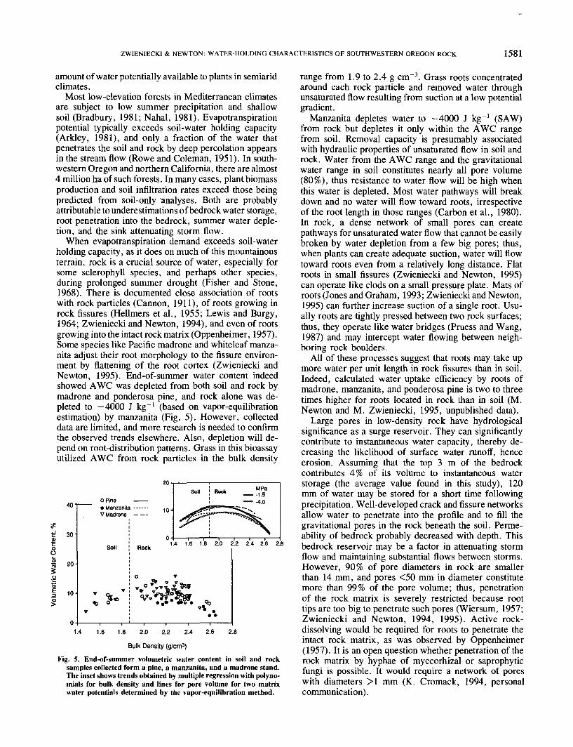
When evapotranspiration demand exceeds soil-waterholding capacity, as it does on much of this mountainousterrain, rock is a crucial source of water, especially forsome sclerophyll species, and perhaps other species,during prolonged summer drought (Fisher and Stone,1968). There is documented close association of rootswith rock particles (Cannon, 1911), of roots growing inrock fissures (Hellmers et al., 1955; Lewis and Burgy,1964; Zwieniecki and Newton, 1994), and even of rootsgrowing into the intact rock matrix (Oppenheimer, 1957).Some species like Pacific madrone and whiteleaf manza-nita adjust their root morphology to the fissure environ-ment by flattening of the root cortex (Zwieniecki andNewton, 1995). End-of-summer water content indeedshowed AWC was depleted from both soil and rock bymadrone and ponderosa pine, and rock alone was de-pleted to —4000 J kg"1 (based on vapor-equilibrationestimation) by manzanita (Fig. 5). However, collecteddata are limited, and more research is needed to confirmthe observed trends elsewhere. Also, depletion will de-pend on root-distribution patterns. Grass in this bioassayutilized AWC from rock particles in the bulk density
40
30-
T3 20-I
S•&I 10
o Pine ——• Manzanita - - - - - -V Madrone — — 10-
Soil ROCK 1.4 1.6 1.8 2.0 2.2 2.4 2.6 2.8
0 *
1.4 1.6 1.8 2.0 2.2 2.4 2.6 2.8
Bulk Density (g/cm3)Fig. 5. End-of-summer volumetric water content in soil and rock
samples collected form a pine, a manzanita, and a madrone stand.The inset shows trends obtained by multiple regression with polyno-mials for bulk density and lines for pore volume for two matrixwater potentials determined by the vapor-equilibration method.
range from 1.9 to 2.4 g cm~3. Grass roots concentratedaround each rock particle and removed water throughunsaturated flow resulting from suction at a low potentialgradient.
Manzanita depletes water to -4000 J kg~' (SAW)from rock but depletes it only within the AWC rangefrom soil. Removal capacity is presumably associatedwith hydraulic properties of unsaturated flow in soil androck. Water from the AWC range and the gravitationalwater range in soil constitutes nearly all pore volume(80%), thus resistance to water flow will be high whenthis water is depleted. Most water pathways will breakdown and no water will flow toward roots, irrespectiveof the root length in those ranges (Carbon et al., 1980).In rock, a dense network of small pores can createpathways for unsaturated water flow that cannot be easilybroken by water depletion from a few big pores; thus,when plants can create adequate suction, water will flowtoward roots even from a relatively long distance. Flatroots in small fissures (Zwieniecki and Newton, 1995)can operate like clods on a small pressure plate. Mats ofroots (Jones and Graham, 1993; Zwieniecki and Newton,1995) can further increase suction of a single root. Usu-ally roots are tightly pressed between two rock surfaces;thus, they operate like water bridges (Pruess and Wang,1987) and may intercept water flowing between neigh-boring rock boulders.
All of these processes suggest that roots may take upmore water per unit length in rock fissures than in soil.Indeed, calculated water uptake efficiency by roots ofmadrone, manzanita, and ponderosa pine is two to threetimes higher for roots located in rock than in soil (M.Newton and M. Zwieniecki, 1995, unpublished data).
Large pores in low-density rock have hydrologicalsignificance as a surge reservoir. They can significantlycontribute to instantaneous water capacity, thereby de-creasing the likelihood of surface water runoff, henceerosion. Assuming that the top 3 m of the bedrockcontributes 4% of its volume to instantaneous waterstorage (the average value found in this study), 120mm of water may be stored for a short time followingprecipitation. Well-developed crack and fissure networksallow water to penetrate into the profile and to fill thegravitational pores in the rock beneath the soil. Perme-ability of bedrock probably decreased with depth. Thisbedrock reservoir may be a factor in attenuating stormflow and maintaining substantial flows between storms.However, 90% of pore diameters in rock are smallerthan 14 mm, and pores <50 mm in diameter constitutemore than 99% of the pore volume; thus, penetrationof the rock matrix is severely restricted because roottips are too big to penetrate such pores (Wiersum, 1957;Zwieniecki and Newton, 1994, 1995). Active rock-dissolving would be required for roots to penetrate theintact rock matrix, as was observed by Oppenheimer(1957). It is an open question whether penetration of therock matrix by hyphae of myccorhizal or saprophyticfungi is possible. It would require a network of poreswith diameters >1 mm (K. Cromack, 1994, personalcommunication).
1582 SOIL SCI. SOC. AM. J., VOL. 60, SEPTEMBER-OCTOBER 1996
CONCLUSIONSWeathered and moderately weathered bedrock, with
well-developed fissure networks penetrable by plantroots, can be a major source of water during prolongedsummer drought for some plants in mediterranean-typeecosystems. This is especially true when soil is shallowand evapotranspiration demand exceeds water-storagecapacity. Bedrock, having lower unit capacity but greaterdepth than soil, is a major storage reservoir. A highproportion of small pores can facilitate unsaturated waterflow toward roots through the rock matrix, with nosignificant changes in resistance to water flow resultingfrom discontinuity.
ACKNOWLEDGMENTSThis study was conducted on land managed by the U.S.
Department of Interior, Bureau of Land Management. Finan-cial support was provided by the USDA National ResearchInitiative Competitive Grants Program. Dr. Kermit Cromackprovided advice and participated in collection of samples.