Embed Size (px)
Citation preview
Water induced disasters, Flood Hazard Mapping & Koshi flood disaster of Nepal
Report prepared for
East & Southeast Asia Regional Seminar on
Flood Hazard Mapping (17-19 Feb, 2009 at Manila, Philippines)
Seminar Organizers
Philippine Atmospheric Geophysical and Astronomical Services Administration (PAGASA), Philippines International Centre for Water Hazard and Risk Management (ICHARM), PWRI, Japan Japan International Cooperation Agency (JICA), Japan
Report submitted by:
Name : Mitra Baral Organization : Department of Water Induced Disaster Prevention Present Post : Engineer Email : [email protected]
Table of contents
1. Introduction…………………………………………………………………….……..2
2. Disaster Mitigation Acts & Policies in Nepal………………...……………………….3
3. Water Induced Disasters…………………….. ……………………………………….4
4. Concerned organizations & situation of Flood Hazard mapping ……………………5
5. Essential FHM data situation………………………………………….……………....7
6. Present problems of Flood Hazard Mapping………………...………………………..7
7. Types of FHM necessary for Nepal………………………..………………………….8
8. Other information’s about FHM………………………………..……………………..8
9. Koshi flood disaster of Nepal………………….…………………………………….9
10. Conclusion……………………………………………………………………….…..13
References…………………………………………………………………..……….14
List of Figures Fig. 1 Map of Nepal ............................................................................................................ 2 Fig. 2 Physiographic regions of Nepal ................................................................................ 2 Fig. 3 Disasters relief comittee ............................................................................................ 3 Fig. 4. Flood in Kathmandu valley ....................................................................................... 4 Fig. 5 Landslide at Naubise road ......................................................................................... 4 Fig. 6 Integrated water-induced map of Ranugn river basin ............................................. 6 Fig. 7 Flood hazard map of Rupandehi district................................................................... 6 Fig. 8 Koshi flood of 2008 ................................................................................................. 10 Fig. 9 Koshi flood disaster of 2008 .................................................................................... 11
1
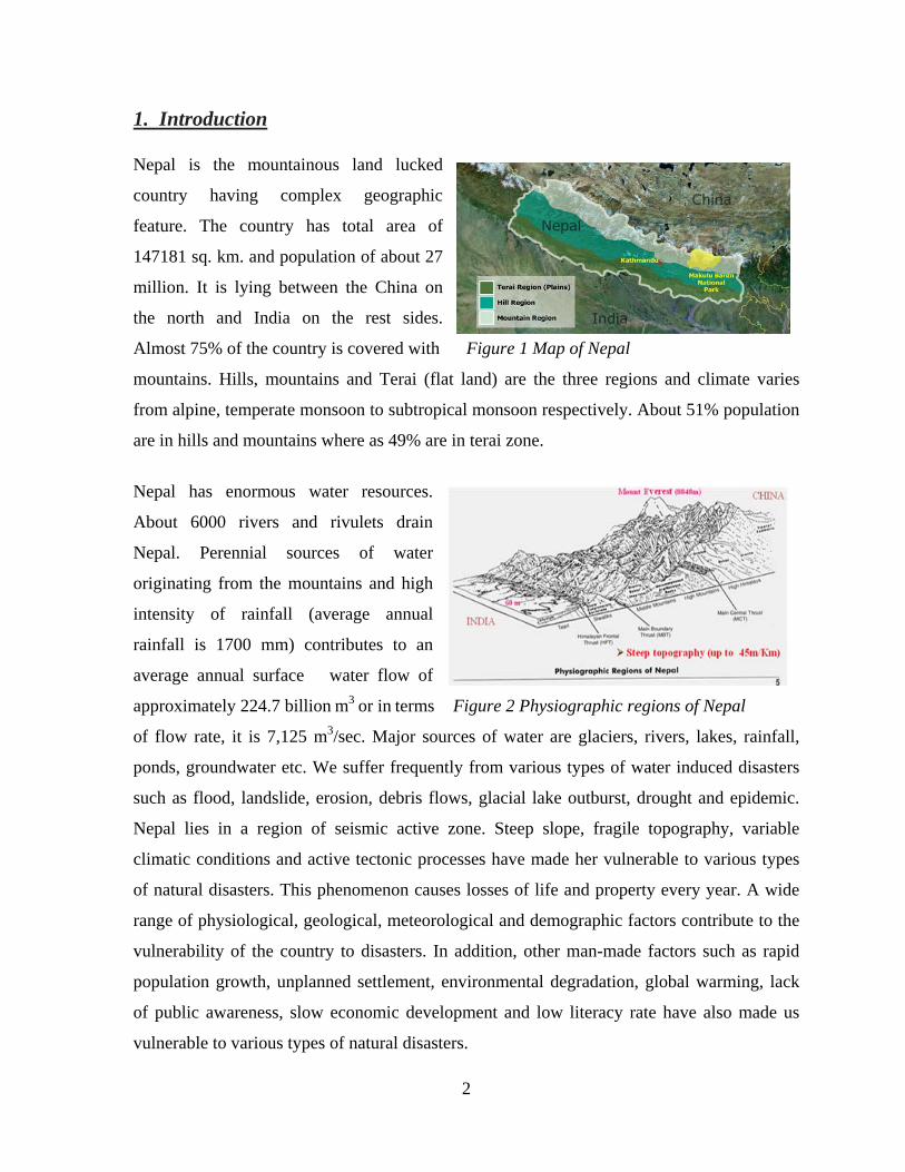
1. Introduction Nepal is the mountainous land lucked
country having complex geographic
feature. The country has total area of
147181 sq. km. and population of about 27
million. It is lying between the China on
the north and India on the rest sides.
Almost 75% of the country is covered with Figure 1 Map of Nepal
mountains. Hills, mountains and Terai (flat land) are the three regions and climate varies
from alpine, temperate monsoon to subtropical monsoon respectively. About 51% population
are in hills and mountains where as 49% are in terai zone.
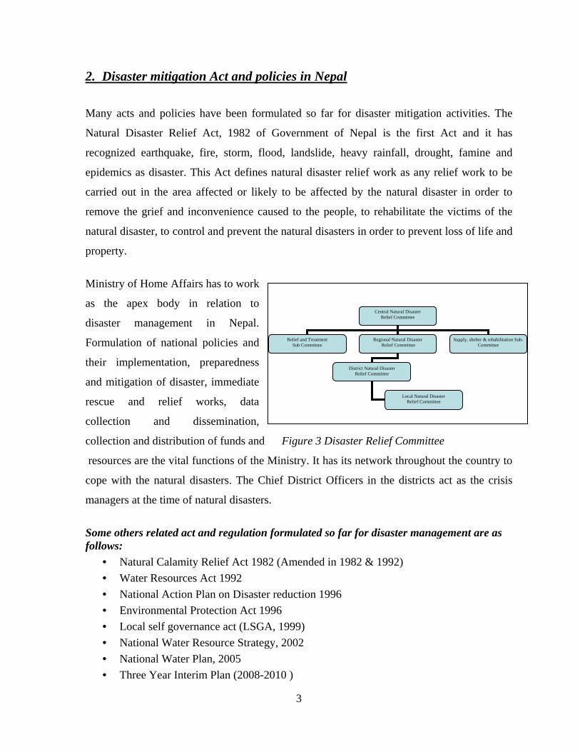
Nepal has enormous water resources.
About 6000 rivers and rivulets drain
Nepal. Perennial sources of water
originating from the mountains and high
intensity of rainfall (average annual
rainfall is 1700 mm) contributes to an
average annual surface water flow of
approximately 224.7 billion m3 or in terms Figure 2 Physiographic regions of Nepal
of flow rate, it is 7,125 m3/sec. Major sources of water are glaciers, rivers, lakes, rainfall,
ponds, groundwater etc. We suffer frequently from various types of water induced disasters
such as flood, landslide, erosion, debris flows, glacial lake outburst, drought and epidemic.
Nepal lies in a region of seismic active zone. Steep slope, fragile topography, variable
climatic conditions and active tectonic processes have made her vulnerable to various types
of natural disasters. This phenomenon causes losses of life and property every year. A wide
range of physiological, geological, meteorological and demographic factors contribute to the
vulnerability of the country to disasters. In addition, other man-made factors such as rapid
population growth, unplanned settlement, environmental degradation, global warming, lack
of public awareness, slow economic development and low literacy rate have also made us
vulnerable to various types of natural disasters.
2
2. Disaster mitigation Act and policies in Nepal
Many acts and policies have been formulated so far for disaster mitigation activities. The
Natural Disaster Relief Act, 1982 of Government of Nepal is the first Act and it has
recognized earthquake, fire, storm, flood, landslide, heavy rainfall, drought, famine and
epidemics as disaster. This Act defines natural disaster relief work as any relief work to be
carried out in the area affected or likely to be affected by the natural disaster in order to
remove the grief and inconvenience caused to the people, to rehabilitate the victims of the
natural disaster, to control and prevent the natural disasters in order to prevent loss of life and
property.
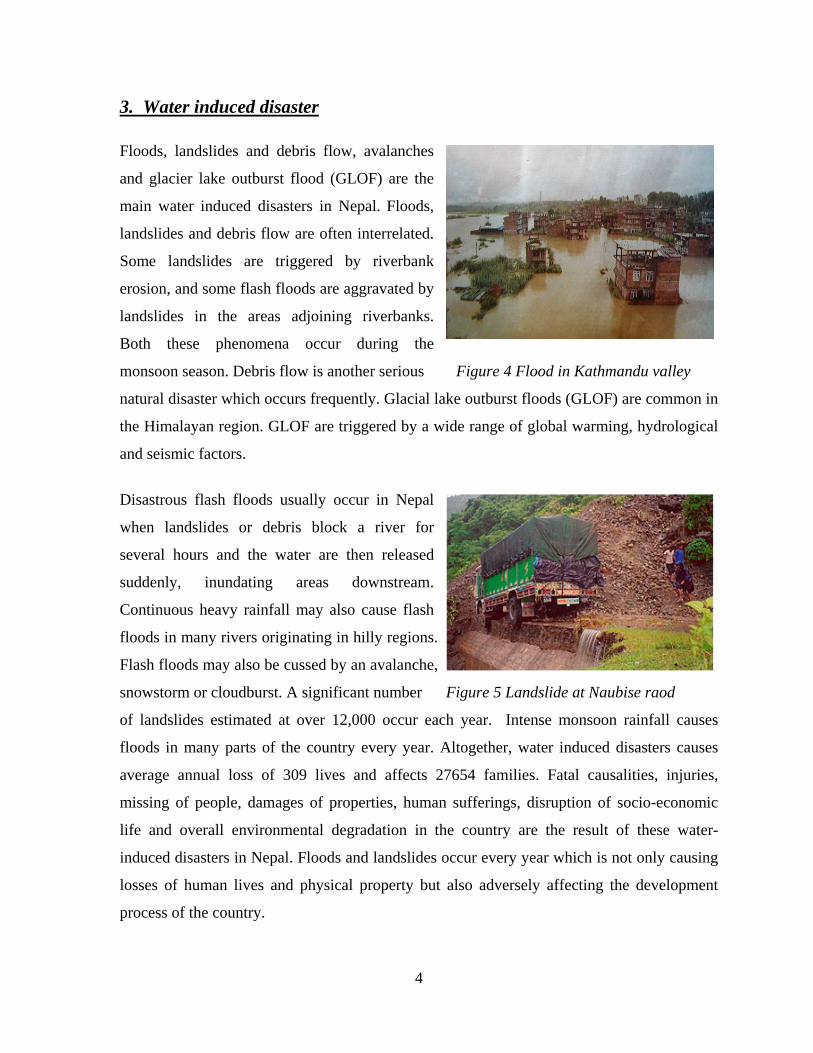
Ministry of Home Affairs has to work
as the apex body in relation to
disaster management in Nepal.
Formulation of national policies and
their implementation, preparedness
and mitigation of disaster, immediate
rescue and relief works, data
collection and dissemination,
collection and distribution of funds and Figure 3 Disaster Relief Committee
Central Natural Disaster Relief Committee
Relief and Treatment Regional Natural Disaster Supply, shelter & rehabilitation Sub-Committee Sub Committee Relief Committee
District Natural Disaster Relief Committee
Local Natural Disaster Relief Committee
resources are the vital functions of the Ministry. It has its network throughout the country to
cope with the natural disasters. The Chief District Officers in the districts act as the crisis
managers at the time of natural disasters.
Some others related act and regulation formulated so far for disaster management are as follows:
• Natural Calamity Relief Act 1982 (Amended in 1982 & 1992) • Water Resources Act 1992 • National Action Plan on Disaster reduction 1996 • Environmental Protection Act 1996 • Local self governance act (LSGA, 1999) • National Water Resource Strategy, 2002 • National Water Plan, 2005 • Three Year Interim Plan (2008-2010 )
3
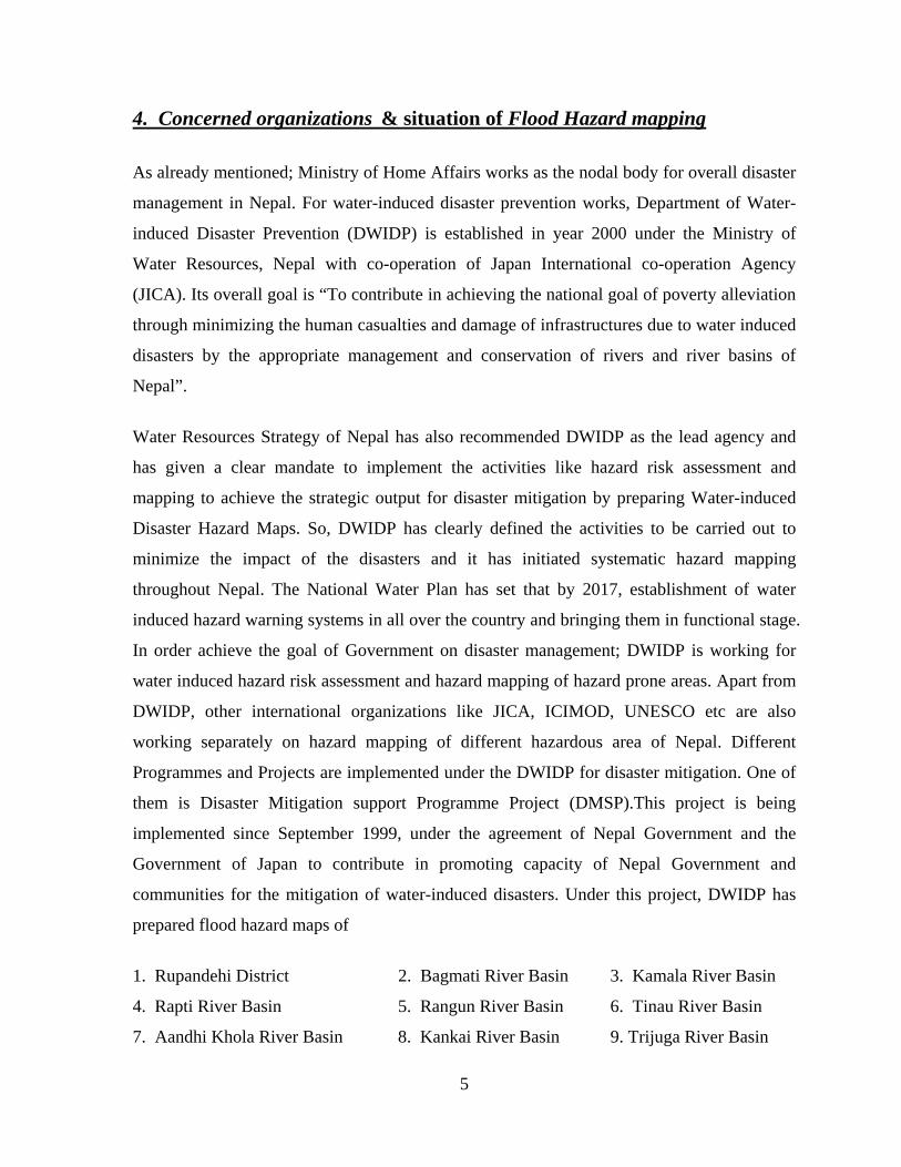
3. Water induced disaster Floods, landslides and debris flow, avalanches
and glacier lake outburst flood (GLOF) are the
main water induced disasters in Nepal. Floods,
landslides and debris flow are often interrelated.
Some landslides are triggered by riverbank
erosion, and some flash floods are aggravated by
landslides in the areas adjoining riverbanks.
Both these phenomena occur during the
monsoon season. Debris flow is another serious Figure 4 Flood in Kathmandu valley
natural disaster which occurs frequently. Glacial lake outburst floods (GLOF) are common in
the Himalayan region. GLOF are triggered by a wide range of global warming, hydrological
and seismic factors.
Disastrous flash floods usually occur in Nepal
when landslides or debris block a river for
several hours and the water are then released
suddenly, inundating areas downstream.
Continuous heavy rainfall may also cause flash
floods in many rivers originating in hilly regions.
Flash floods may also be cussed by an avalanche,
snowstorm or cloudburst. A significant number Figure 5 Landslide at Naubise raod
of landslides estimated at over 12,000 occur each year. Intense monsoon rainfall causes
floods in many parts of the country every year. Altogether, water induced disasters causes
average annual loss of 309 lives and affects 27654 families. Fatal causalities, injuries,
missing of people, damages of properties, human sufferings, disruption of socio-economic
life and overall environmental degradation in the country are the result of these water-
induced disasters in Nepal. Floods and landslides occur every year which is not only causing
losses of human lives and physical property but also adversely affecting the development
process of the country.
4
4. Concerned organizations & situation of Flood Hazard mapping
As already mentioned; Ministry of Home Affairs works as the nodal body for overall disaster
management in Nepal. For water-induced disaster prevention works, Department of Water-
induced Disaster Prevention (DWIDP) is established in year 2000 under the Ministry of
Water Resources, Nepal with co-operation of Japan International co-operation Agency
(JICA). Its overall goal is “To contribute in achieving the national goal of poverty alleviation
through minimizing the human casualties and damage of infrastructures due to water induced
disasters by the appropriate management and conservation of rivers and river basins of
Nepal”.
Water Resources Strategy of Nepal has also recommended DWIDP as the lead agency and
has given a clear mandate to implement the activities like hazard risk assessment and
mapping to achieve the strategic output for disaster mitigation by preparing Water-induced
Disaster Hazard Maps. So, DWIDP has clearly defined the activities to be carried out to
minimize the impact of the disasters and it has initiated systematic hazard mapping
throughout Nepal. The National Water Plan has set that by 2017, establishment of water
induced hazard warning systems in all over the country and bringing them in functional stage.
In order achieve the goal of Government on disaster management; DWIDP is working for
water induced hazard risk assessment and hazard mapping of hazard prone areas. Apart from
DWIDP, other international organizations like JICA, ICIMOD, UNESCO etc are also
working separately on hazard mapping of different hazardous area of Nepal. Different
Programmes and Projects are implemented under the DWIDP for disaster mitigation. One of
them is Disaster Mitigation support Programme Project (DMSP).This project is being
implemented since September 1999, under the agreement of Nepal Government and the
Government of Japan to contribute in promoting capacity of Nepal Government and
communities for the mitigation of water-induced disasters. Under this project, DWIDP has
prepared flood hazard maps of
1. Rupandehi District 2. Bagmati River Basin 3. Kamala River Basin
4. Rapti River Basin 5. Rangun River Basin 6. Tinau River Basin
7. Aandhi Khola River Basin 8. Kankai River Basin 9. Trijuga River Basin
5
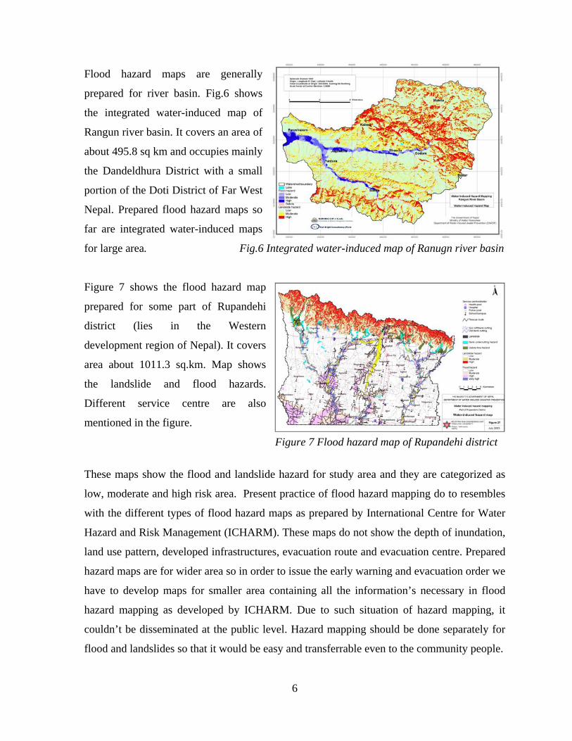
Flood hazard maps are generally
prepared for river basin. Fig.6 shows
the integrated water-induced map of
Rangun river basin. It covers an area of
about 495.8 sq km and occupies mainly
the Dandeldhura District with a small
portion of the Doti District of Far West
Nepal. Prepared flood hazard maps so
far are integrated water-induced maps
for large area. Fig.6 Integrated water-induced map of Ranugn river basin
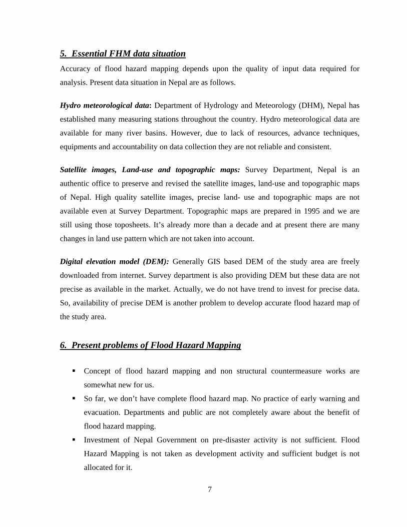
Figure 7 shows the flood hazard map
hese maps show the flood and landslide hazard for study area and they are categorized as
flood and landslides so that it would be easy and transferrable even to the community people.
prepared for some part of Rupandehi
district (lies in the Western
development region of Nepal). It covers
area about 1011.3 sq.km. Map shows
the landslide and flood hazards.
Different service centre are also
mentioned in the figure.
Figure 7 Flood hazard map of Rupandehi district
T
low, moderate and high risk area. Present practice of flood hazard mapping do to resembles
with the different types of flood hazard maps as prepared by International Centre for Water
Hazard and Risk Management (ICHARM). These maps do not show the depth of inundation,
land use pattern, developed infrastructures, evacuation route and evacuation centre. Prepared
hazard maps are for wider area so in order to issue the early warning and evacuation order we
have to develop maps for smaller area containing all the information’s necessary in flood
hazard mapping as developed by ICHARM. Due to such situation of hazard mapping, it
couldn’t be disseminated at the public level. Hazard mapping should be done separately for
6
5. Essential FHM data situation Accuracy of flood hazard mapping depends upon the quality of input data required for
analysis. Present data situation in Nepal are as follows.
and Meteorology (DHM), Nepal has
stablished many measuring stations throughout the country. Hydro meteorological data are
l is an
uthentic office to preserve and revised the satellite images, land-use and topographic maps
of the study area are freely
ownloaded from internet. Survey department is also providing DEM but these data are not
oblems of Flood Hazard Mapping
Hydro meteorological data: Department of Hydrology
e
available for many river basins. However, due to lack of resources, advance techniques,
equipments and accountability on data collection they are not reliable and consistent.
Satellite images, Land-use and topographic maps: Survey Department, Nepa
a
of Nepal. High quality satellite images, precise land- use and topographic maps are not
available even at Survey Department. Topographic maps are prepared in 1995 and we are
still using those toposheets. It’s already more than a decade and at present there are many
changes in land use pattern which are not taken into account.
Digital elevation model (DEM): Generally GIS based DEM
d
precise as available in the market. Actually, we do not have trend to invest for precise data.
So, availability of precise DEM is another problem to develop accurate flood hazard map of
the study area.
6. Present pr
uctural countermeasure works are
somewhat new for us.
completely aware about the benefit of
t taken as development activity and sufficient budget is not
allocated for it.
Concept of flood hazard mapping and non str
So far, we don’t have complete flood hazard map. No practice of early warning and
evacuation. Departments and public are not
flood hazard mapping.
Investment of Nepal Government on pre-disaster activity is not sufficient. Flood
Hazard Mapping is no
7
No trend and culture to invest on hydro-meteorological observation, data collection
and research activity which are essential for inundation analysis, flood hazard
mapping and development of early warning system.
7. p
Flood Hazard Maps developed by Departments are not complete for dissemination.
Lack of availability of precise data and softwares for inundation analysis and flood
hazard mapping.
Ty es of FHM necessary for Nepal (As described by ICHARM)
ent of Hydrology & Meteorology of Nepal isDepartm collecting data of different river basins
regularly. Even though there are problems on collected data, some of the data sets are reliable.
ore precise Further improving the data collecting system, we would be able to manage m
hydrological data and rely on it. With such data sets we can perform rainfall runoff modeling.
If we will be able to manage other GIS based data and inundation analysis software, we can
perform inundation analysis and produce flood hazard map precisely. So, we are in a stage of
producing maps based on inundation analysis (i.e. maps type E, F &, G as proposed by
ICHARM).
8. Other information’s about FHM Government of Nepal has taken privatization policy in communication system. These days
we have many private television and FM radio stations. Telecommunication and internet
spapers are published even at regional and local system are established in many districts. New
level. So we can say that we have good communication system for information dissemination
at the time of disaster. Department of Hydrology and Meteorology provides information and
forecast about weather and rainfall. Generally Ministry of Home and chief district officer
issues evacuation order at the time of harsh and abnormal rainfall and weather condition.
Apart from government many other social and nongovernmental organizations such as Nepal
Red Cross Society, UNOCHA, JICA, UNICEF, Rotary, Save the Children etc are assisting in
awareness raising, rescue operation, relief activity and evacuation at the time of water
induced disasters.
8
9. Koshi flood disaster of Nepal
The Koshi Basin is the largest river basin of Nepal. It originates from the Tibetan Plateau of
The Koshi enters Bihar (Northern most State of
dia) and finally ends at the confluence of Ganges, travelling from Nepal. It may be the only
China and in high Himalayas of Nepal.
In
river in the world which has horizontally changed its course as much as 120 km in the last
250 years. Floods from the Koshi river in the past have created havoc in the downstream area
of Nepal and India leading to loss of lives and property and causing widespread human
suffering.
Some features of Koshi river
• Total length 729 km.
• Catchment area 60,400 Sq.Km.
90 m3/sec.
m in Nepal and up to 18 km in India.
e: 118 million cubic meter.
c (25849 m3/sec ;5th Oct.1968)
8)
In
pro t struction of Barrage,
oshi River was known as the “sorrow of Bihar” due to flooding in the monsoon and drought
• Average annual flow 15
• River width: Up to 11k
• Average annual sediment volum
• Past maximum flood : 913,000 cuse
• Recent Flood: 168,500 cusec ( 4770 m3/sec; 18th August, 200
1954, with an objective of flood control, irrigation and hydropower generation, Koshi
jec agreement was signed between India and Nepal. Before the con
K
in winter. It became the “pride of India” (Bihar) when the Barrage was completed. It was
constructed between 1955 and 1963 on the Nepal side of the Indo-Nepal border. The Koshi
Barrage has a discharge capacity of 950,000 cusecs ( 26896 m3/sec) in a peak flood.
Koshi project
• Agreement in April, 1954.
• 1150 m long barrage with 56 gates.
d regulator for canals (Eastern: 612,500ha & Western 356,610 ha).
( 11 km d/s of Barrage at eastern canal).
• Two hea
• Power generation of 20 MW
9
10
with 57 numbers of spurs in Nepal).
al).
Some clauses of Koshi Project treaty:
• Earthen Left embankment 144 km (32 km
• Earthen Right embankment 125 km (25 km with 51 numbers of spurs in Nep
• Length of spur; 150 – 300 m.
• Nepal territory leased for 199 years.
be authorized to conduct necessary investigation
for storage or detention for dams on the Koshi or its tributaries - soil conservation,
prevention of future problems (Art. 2.2).
ensation for
•
Koshi Flood Disaster of 18
• The Government of India (GoI) shall
check dams, forestation, etc. for
• Nepal shall provide necessary lands to execute the said project (Art. 3.1) and
compensation of land to be provided by India to Nepal (Art. 3.2). India shall execute
all necessary repair work and maintenance, and if incident occurs, comp
every damage case shall be provided to Nepal (Art. 3.3).
India shall be the owner of all lands acquired from Nepal. The sovereignty rights and
territorial jurisdiction of the Government in respect of such lands shall continue
unimpaired by such transfer (Art.5).
• Nepal shall be responsible for ensuring security in the project areas (Art. 14).
th August 2008
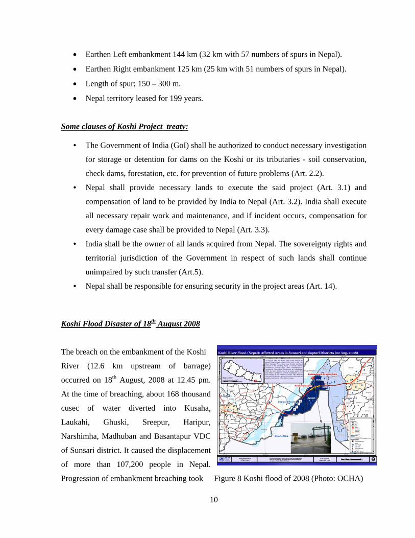
he breach on the embankment of the Koshi
e)
ccurred on 18th August, 2008 at 12.45 pm.
Progression of embankment breaching took Figure 8 Koshi flood of 2008 (Photo: OCHA)
T
River (12.6 km upstream of barrag
o
At the time of breaching, about 168 thousand
cusec of water diverted into Kusaha,
Laukahi, Ghuski, Sreepur, Haripur,
Narshimha, Madhuban and Basantapur VDC
of Sunsari district. It caused the displacement
of more than 107,200 people in Nepal.
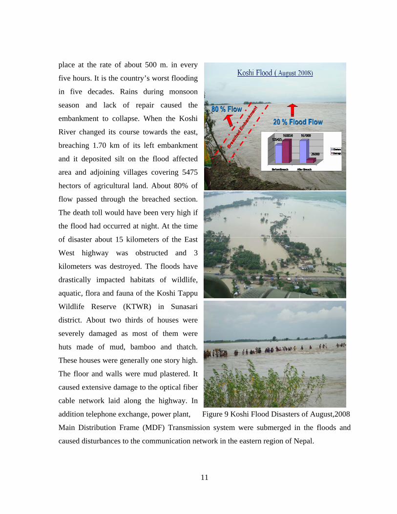
place at the rate of about 500 m. in every
five hours. It is the country’s worst flooding
five decades. Rains during monsoon
on system were submerged in the floods and
ork in the eastern region of Nepal.
in
season and lack of repair caused the
embankment to collapse. When the Koshi
River changed its course towards the east,
breaching 1.70 km of its left embankment
and it deposited silt on the flood affected
area and adjoining villages covering 5475
hectors of agricultural land. About 80% of
flow passed through the breached section.
The death toll would have been very high if
the flood had occurred at night. At the time
of disaster about 15 kilometers of the East
West highway was obstructed and 3
kilometers was destroyed. The floods have
drastically impacted habitats of wildlife,
aquatic, flora and fauna of the Koshi Tappu
Wildlife Reserve (KTWR) in Sunasari
district. About two thirds of houses were
severely damaged as most of them were
huts made of mud, bamboo and thatch.
These houses were generally one story high.
The floor and walls were mud plastered. It
caused extensive damage to the optical fiber
cable network laid along the highway. In
addition telephone exchange, power plant,
Main Distribution Frame (MDF) Transmissi
caused disturbances to the communication netw
Figure 9 Koshi Flood Disasters of August,2008
11
Disaster scenario of Koshi flood 2008 in Nepal (Source: Ministry of Home Affairs, Nepal)
• About 107,200 people of 8 VDC (4 completely, 4 partially) in Sunsari districts were
affected.
• people were kept in 28 different temporary shelter camps.
arge size
, Goat, Pig)]
ase like cholera, diarrhea,
Dis e
• 1 human death was reported at the time of disaster. The total human death toll is 8.
• The national highway was damaged at several places by the flood.
Displaced
• 56751 displaced people of 7995 families (NRC, 2/9/2008) were taken to the
temporary shelters.
• Domestic animals of 55000 effected, 20000 displaced.
• 14571 Domestic animals were killed [Small size 3270 (Chicken, Duck), l
11301(Cow, Buffalo
• 5500 people were rescued within three days of disaster.
• 3 Helicopters, 10 rafting boats, 3 ordinary boats, 4 elephants mobilized for rescue and
distribution of relief materials.
• Many people suffered from different type of dise
pneumonia, eye conjunctivitis, fever etc.
ast r scenario of Koshi flood 2008 in India ( Source: Ministry of Home Affairs, India)
About 30,65,000 people from 1704 villag
• es in 16 districts have been affected.
• 7 human deaths have been reported by the State from 29.08.2008 to 30.08.2008. The
• e for rescue and relief operations.
ted.
reas of district
total human death toll of the State is 54.
• 2,83,797 houses are reported to have been damaged due to flood.
• 3,78,826 persons have been evacuated from the affected areas so far.
2036 boats have been pressed into servic
• In 182 relief camps about 1,14,278 people have been accommoda
• 6 mobile health teams have also been mobilized in the affected a
Supaul.
• In 96 cattle camps about 6764 animals have been treated.
• 158 Health Centre have also been opened in the flood affected areas.
12
Rea nso s of Koshi flood disaster
• Unequal Koshi project treaty
ear) due to excess sediment load.
• Concentration of flow towards eastern embankment and striking since last 8 years
anism and maintenance activity.
easure works like rising of awareness, development of
damage.
Co l
• Rise of bed level (0.05m/y
• Lack of regular monitoring mech
• Over confidence about the strength of structures
• Problem of security at the site.
• Lack of good coordination between Nepal & India. Trend of blaming each other
• No proper emergency response activity
• Lack of nonstructural counterm
early warning system and flood hazard mapping.
• No experience about the extent of flood
nc usion In Nepal, disaster mitigation is considered as a humanitarian activity and more focus is given
r activity. Normally we allocate budget for structural countermeasure works
nd post disaster activity. In order to minimize the risk from flood hazard, both structural and
on post disaste
a
nonstructural mitigation measures works are equally important. Rather than relying
completely on large structural measures, which may not be sustainable due to present
economic condition of the country, policies and guidelines need to be developed and
implemented for non-structural countermeasures against flood hazards at the community
level together with structural countermeasure works. Present practice of nonstructural
countermeasure works such as flood hazard mapping is not reliable. Hence it is essential to
develop methodology to improve present flood management system with nonstructural
countermeasures. Such non structural countermeasure of flood risk reduction is possible with
rainfall runoff modeling, inundation analysis and flood hazard mapping. We can’t control the
hazards but its effects can be tremendously minimized with an application of hazard mapping
and early warning system. So we should improve our policy to develop hazard maps and
early warning system considering it as a development activity with active people’s
13
participation. Some of the water induced disaster problems in Nepal are due to transboundary
conflict and lack of co-ordination with neighbor country, India. Present Koshi flood disaster
is one of the example of such disaster. So, government has to set up policy to develop
bilateral coordination and co-operation with India to solve such boundary water induced
disasters problem.
References:
epartment of Water induced Disaster Prevention. DWIDP Bulletins; www.dwidp.gov.np D
inistry of Home Affairs Nepal; www.moha.gov.npM .
ome Affairs, India; Disaster Management Division, Southwest monsoon-2008
saster Management Department
Ministry of HDaily flood situation report, 31ST August, 2008; SITREP NO-92/2008, 32-20/2008-NDM-I Nepal Red Cross Society, National Headquarters, Di
ndKoshi Disaster update No.15 2 September, 2008. OCHA, Office for Co-ordination of Humanitarian Aid. Report No. 10 Central Bureau of Statistics; www.cbs.gov.np
Saptakoshi loss assessment & Saptakoshi integrated action plan report; Prime Minister’s
Office, Kathmandu, Nepal
http://www.un.org.np
14