Embed Size (px)
Citation preview
BEPLS Vol 4 [11] October 2015 30 | P a g e ©2015 AELS, INDIA
Bulletin of Environment, Pharmacology and Life Sciences Bull.Env.Pharmacol.LifeSci.,Vol4[11]October2015:30-37©2015AcademyforEnvironmentandLifeSciences,IndiaOnlineISSN2277-1808Journal’sURL:http://www.bepls.comCODEN:BEPLADGlobalImpactFactor0.533UniversalImpactFactor0.9804
ORIGINAL ARTICLE OPEN ACCESS
Water Resource Development by Using Water Evaluation and Planning system “WEAP” (Case Study: Masouleh River)
1Rahil Rahimi, 2*Leila Ooshaksaraieand 3Hasn Karimzadegan
1-MasterStudent,DepartmentofEnvironmentalEngineering,FacultyofNaturalResources-LahijanBranch-IslamicAzadUniversity,Iran;
2-DepartmentofEnvironmentalEngineering,FacultyofNaturalResources-LahijanBranch-IslamicAzadUniversity,Iran
3-DepartmentofEnvironmentalEngineering,FacultyofNaturalResources-LahijanBranch-IslamicAzadUniversity,Iran.
*Correspondingauthor:e-mail::[email protected]
ABSTRACT In all the worldrenewable water resource is decreasing. Masouleh River in Guilan Province, is supplied by Sefidroud dam and ground water that finally leads to Anzali Wetland. River modeled for 25 years by using Water Evaluation and Planning System (WEAP). In this research, based on comparison between the designed scenarios (reference, change of demand priority and population growth) in development section, maximum amount of water lack is in population growth scenario (211 million cubic meter in 25 years). In the case of development and progress in the region of case study, the water need that has not been supplied for agriculture section will be decreased about 30 million cubic meter during future 25 years in comparison with the reference scenario. The only scenario that shows increase in request and unsupplied needs in rural district in the results of model is population growth scenario.To solve the mismatch between demand and supply, improve in water distribution and use of new methods in resource utilization can be useful and in addition paying attention to change in need and demand management will be also useful. Demand management is hard in practice but if water is present, its distribution is easier. Key Words:: sustainable development/Water evaluation and planning system WEAP/ water resources management/ Masouleh river
Received04.08.2015 Revised20.09.2015 Accepted01.10.2015 INTRODUCTIONInIran,about60%oflandsareunderwatercultivationthatprovides90%ofstatefoodstuffsproduction[4].Regardingtounsuitablelocaldistributionofraininthecountryandlackoftimeaccordanceofrainingwithirrigationseason,watercrisisisaseriousproblem.Certainlyinanearfuture,Iranwouldencounterto lack of renewable water resources for continuation of agricultural activities and providing itsnecessities.Consequently,inordertocounterwiththiscrisis,waterresourcesmustbemanagedthroughthe most economized and executable methods [16]. Guilan province has more than 44 rivers that anymanipulation in their domain would cause danger for constructed installations and structures due tohappenanyfloodinadditiontodestructionoftheriverssystem[3]. If thesurfacewaterswouldnotbecontrolledortheundergroundwaterresourceswouldnotbeaccuratelyused,theywouldbeconsideredtwo main problems in the fieldof incrementand developmentofagriculturalproducts in the regionofcasestudyespeciallyinthedroughttimes[13].Theexistingevidencesindicatebeingcriticalofthewaterresourcesstatus.Thismatterneedsnecessityofmoreconsiderationtowaterresourcesmanagementandoptimized using them [1]. Surface runoffs are applied in domestic, irrigation, industrial and urbanconsumptions. Quantity and qualification of surface waters are managed with management methodssimilartotheupperlands[2].Incrementofharvestingandmorecompetitioninsurfacewaterscausedtofinancial and technological limitations would stop satisfied development and explore of undergroundwaters and resources storages. Decrease of flow and groundwater recharge due to weather changesintensifies this situation. For this reason, more techniques are required especially in rural districts [8].Dissolving the water shortage problems, qualification decay and increase of demand and renewable

BEPLS Vol 4 [11] October 2015 31 | P a g e ©2015 AELS, INDIA
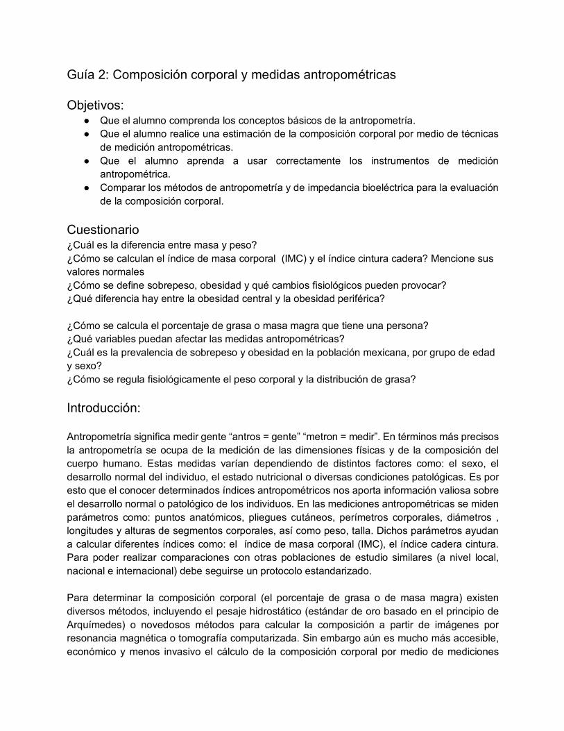
energies in hydraulic systems require planning, management and computer simulation. Suchmanagementmethodshelptosustainableusageofwaterresources[9].WEAPactsasatoolforanalyzingofwaterresourcespoliciesandplanningintheintegratedframework.ThegainedresultsarepresentedthatWEAPisacompleteusefultoolforstudyondifferentoptionsofwatermanagementanddevelopment[19].Manyregionsarefacingformidablefreshwatermanagementchallenges.Allocationoflimitedwaterresources,environmentalqualityandpoliciesforsustainablewateruseareissuesofincreasingconcern[10]. The systemis represented in termsof itsvariouswatersources(e.g., surface water,groundwaterand water reuse elements); withdrawal, transmission, reservoirs, and wastewater treatmentfacilities, and water demands (i.e. user-defined sectors, but typically comprising industry, mines,irrigation and domestic supply) [12,17,19]. One of software limitations is shortage in available andhomogenous water date in domain, especially ground waters data. Additionally, lack of reliablepredictionsonweathervarietyinfuturewouldincreaseincoherenceprobabilityinfuturesimulations[7].MasoulehriverbasinlocatedinGuilanProvinceisselectedasacasestudyarea.Masoulehisapermanentriverthatitsoriginisin3000mheightoftheregionanditslenghtisabout60[18].Riversareinfluencedby their natural changes, deep reformation due to effective human activities. Principal operation usingrivermanagementsciencemayplanthebesttypeofconsumption.ObjectiveofthisresearchistoevaluatetheamountofinfluenceofdevelopmentresultsonMasoulehRiverwithconsiderationtoexistencedataandapplyingWEAPSoftwareandstudymanagementtechniques.MATERIAL AND METHOD Masuleh River is one of the main and permanent rivers in region that is the main agricultural waterresourceintheFumanatplaininthenorthofIran.Itsbasinis426.7Km2thatMasoulehriverflowsfromFooman,SomeesaraandMasulehurbantoAnzaliwetland[6],MasoulehriverbazinispresentedinFigure
1[5]. Masuleh river basin covers about 17% from the Foumanat plains that there are three waterresources for different consumptions; 96% agriculturing consumption, 4% drinking and industrialconsumption[15].Regionalflowingriversischargingfromthehighlandsofnorthwest,westandsouthwestofthestudyarea,andisflowingtothewesttotheeastandsouthwesttothenortheast[18].All data related to Masuleh river basin such as climatic data, annual and monthly hydrometer statics,annual and monthly average discharge for 1986 to 2011 water years, are gathered from the GuilanregionalWatercompany.In the WEAP software there are schematic that shows river, water needed place, catchment area,groundwater,and...thatwithplacingeachonecanenterednewdatainthemodel.Inthefollowingmodel,Masouleh basin, Sefidrud basin, Masouleh river, 3-point demands (agricultural, industrial, rural), theminimum environmental required point and water supply (rivers, groundwater and Sefidrud dam) isspecified.MinimumenvironmentalrequiredpointwasdefinedwheretheriverflowsintotheAnzalywetland.Thisamount is calculated by estimation 10% of the river average discharge during the months October toMarchand30percentoftheriveraveragedischargeinthemonthsofApriltoSeptemberwasentered.Thescenarioshavebuiltonexistingconditionsandtheireffectonthewateraccessandconsumptionhasbeensurveyedinthefuture.Theperiodwhichconsideredforscenarioisfrom2011to2035,thesoftwarehaspredictedtheconditionsupto2035,basedontheexistingdatawerecollectingduring25years(upto2011). Inheriting from the scenarios is a subset of a scenario that means inherit properties from pre-scenario.Inaddition,newconditionscanbedescribeorenterednewdata.Design scenarios are: 1 - Reference scenario: this scenario inherited input data up to 2011 as the baseyearandthewatersituationpredictiondeterminedbetween2012and2035.Thepopulationgrowthrateiscalculated0.7%asthebaseyearinthisscenario.2–changingDemandpriorityscenario:Dischargeandpopulation changes, all conditions are the same as the reference scenario. The only difference is thedemandpriority.Inthisscenario,theagriculturalneeds-towardstheneedsofindustryandrural-areatthesecondpriority.3-Populationgrowthscenario:includingtheconstantwaterflowtothearea,andbyinheriteddatafrom2012-2035ofreferencescenario,thepopulationgrowthratehasbeenestimated2%by2035andsurveyedthedemandrate.
Rahimi et al
BEPLS Vol 4 [11] October 2015 32 | P a g e ©2015 AELS, INDIA
Figure1.[5]
RESULTS By the results gained from the WEAP software and gathered data and information the conclusion isconductedandtherecommendationsandsuggestionsprovidethatisshowninFigure2.
Figure2.Masulehriverunsupplieddemandchangesinpopulationgrowthscenariobydemandpoint
divisionin2035inmapsandchartsformat.
Referencescenario:Totalannualwaterneedis22.7MCMthatincludesagricultural,industrialandruralwaterneedsrespectively19.7,2and1MCM.Monthly agricultural water need was changed in April to September (0.02 to 0.8 MCM). Its for othermonths of the year is 0. Industrial and rural water need is respectively 0.08 and 0.09 MCM. Monthlyindustrialwaterneedis0.08to0.09MCMandruralwaterneedisabout0.09MCM.Annuallyagricultural,industrial and rural water need are respectively 6.1, 1 and 1 MCM and for the all demand points is8.1MCM. Unsupplieddemandhasbeenchanging25years.Itsrateincreasesfrom6.1to7.07MCMinagriculturalneeds,1to1.07MCMinindustrialneeds,and1to1.21MCMinruralneedsfrom1to1.21MCM.Thefinalrateis206.6MCMin2035for25years(Figure3).
Figure3.unsuppliedwaterdemandinreferencescenarioforalldemandpoints(years2011to2035)
In the reference scenario annually unsupplied demand is changeable. The agricultural, industrial andrural water need are respectively 70 to 80% , 45 to 55% and 0 in April- September.Demand priorities
Rahimi et al
BEPLS Vol 4 [11] October 2015 33 | P a g e ©2015 AELS, INDIA
changing scenario: the unsupplied demand is changeable in this scenario during 25 years. The ratechangesfrom6.1MCMto4.9inagriculturalneeds,1MCMto1.2intheindustrialneeds,andfrom1to1.1MCMinruralneeds.179MCMistheratefor25yearsin2035(Figure4).
Figure4.thewaterunsupplieddemandofdemandprioritychangingscenarioforallpoints(2011to
2035)
Populationgrowthscenario:unsupplieddemandischangeablefor25years.Itchangesfrom6.1MCMto7.1foragriculturalneed,1to1.1MCMforindustrialneedand1to1.6forruralneedsin2011to2035.Thisrateis211.6MCMforall25yearsin2035(Figure5).
Figure5.Thewaterunsupplieddemandinpopulationgrowthscenarioforalldemandpoints(2011to
2035)
Thedemandrangeisconstantover25years.Thisrate from2011to2035is19.7MCMforagriculturalneeds,2MCMforindustrial(notshowanychanges).Demandrangeincreasefrom1to1.6MCMforruralneeds.Thisrateis574.6MCMfortotalof25years(Figure6).
Figure6.Waterdemandofpopulationgrowthscenarioforalldemandpoints(to2035)
Comparisonbetweenthereferencescenarioanddemandprioritychangescenario:Thisrateforagriculturalneedsisfrom7.1MCMinreferencescenarioto4.9indemandprioritychangescenario.Itreducedfrom153to123.2MCMduring25years(Figure7).
Rahimi et al

BEPLS Vol 4 [11] October 2015 34 | P a g e ©2015 AELS, INDIA
Figure7.Comparisonbetweenwaterunsupplieddemandbetweenreferencescenarioandthedemand
prioritychangescenariointheagriculturalneedspoints.
Waterneedforindustrialchangesfrom1.1MCMinreferencescenarioto1.1indemandsupplypriorityscenario that means water need is almost identical for both scenarios in 2035 but reason to predictedfluctuations,itincreasesby9.25MCMto28in25years(Figure8).
Figure8.waterunsupplieddemandcomparisonbetweenthereferencescenarioandthedemandpriority
changingscenarioinindustrialdemandpoint.
Itsamountis1.2MCMinruralneedswithoutanychanges.Thewaterunsupplieddemandis27.8MCMinbothscenarios(Figure9).
Figure9.waterunsupplieddemandscomparisonbetweenthereferencescenarioandthedemand
prioritychangingscenariointheruralpoints.
Referencescenarioandpopulationgrowthscenariocomparison:The water unsupplied demand for agricultural use is 7.1 MCM in both scenarios in 2035, without anychanges(Figure10).
Rahimi et al

BEPLS Vol 4 [11] October 2015 35 | P a g e ©2015 AELS, INDIA
Figure10.waterunsupplieddemandcomparisonbetweenreferencescenarioandpopulationgrowth
scenariointheagriculturalneedspoint.
water unsupplied demand in The Industrial need is 1.07 MCM in both scenarios in 2035, without anychanges(Figure11).
Figure11.waterunsupplieddemandcomparisonbetweenreferencescenarioandpopulationgrowth
scenariointheindustrialpoint.
Thewaterunsupplieddemandforruralneedsincreasesfrom1.21MCMonthereferencescenarioto1.64on the population growth scenario. It increases from 27.76 MCM to 32.67 MCM during 25 years(Figure12).
Figure12.waterunsupplieddemandcomparisonbetweenthereferencescenarioandthepopulation
growthscenariointheruralneedpoints. DISCUSSION AND CONCLUSIONS in a research study with Iran Hydropoletic water condition title, the water status in comparison withother countries has Shown that the water crisis in the future and Renewable water per capita hasdeclinedduetoincreasedconsumptioninthecountryandWillbelowerthantheinternationalstandard[14].StudiestoidentifysourcesofgroundwaterFoumanatplainandqualitativechangesandfactorsaffectonregionalwaterbalanceInanarticletitled“FoumanatplainUnderstandinggroundwaterresourcesandtheir qualitative changes” has indicated that This basin has discharge remarkably good quality for
Rahimi et al

BEPLS Vol 4 [11] October 2015 36 | P a g e ©2015 AELS, INDIA
drinking,irrigationandindustry[13].MassuleRiverFloodControlProjectinHydrologyReport,Source,slope, aspect and elevation are calculated [15]. In the article "Introducing WEAP software as a tool tointegratewaterresourcesmanagement."ChangesresultingfromthedevelopmentofwaterresourcesintheHarazriverBasincheckedandshownthatthedevelopmentofthisareahasthegreatestimpactontheagriculturalsector[11].Inarticleentitled"TheUseofWaterEvaluationandPlanning(WEAP):Amodelfor assessing the future demand for water in the river Niger (Republic of Niger) ", showing the futureneeds of its population is optimized River Niger [10]. The results obtained from the present articlereviewsresearchconfirmsprevious.ThereareseveralpointsintheMasulehriverbasinthathavebeensurveyedandappliedinthemodeling.Locationofthedemandpointisbaseontheexistentnaturalconditionwhichisalsovisibleonthemap.Thus the paints get in to position under the river flowing direction and places has been placed in damnetworkbecauseofwaterusageofSefidruddam.Alsodemandsupplyresourceshasbeenmarkedonthemap based on their natural placement for several scenarios planning. The minimum ecologicalrequirementpointmarkedattheriverflowingrateatthewetlandconjunction.Estimatingthevolumeofwater which would have normally entered in the wetland, emphasized on the importance of riverdecontamination.ExtrywayDebbietoapplicationwasderivedfromtheKumadolstationsthiswasdonefortworeasons,first:Thisstationhastheleastdistancetodemandpointsratherthantheotherstations.Second;themostimportantinputbranchestoRiverlocatedbeforethisstation.Thus,theinputDebbieofthisiscalculated.Itisnecessarytoexplainsomepantsaboutthenselectingviewandchoosingcharts:1-Model studying period is 25-years, if the results has been shown, there will be complexity in threedemandpointinthisperiod,thatisnotveryappealingtotheviewer.2-Thereisaviewinamodelresultsshowing threedemandpoints ina column. Incaseswhere there isbalanced betweenpoints,using thischartmakesiteasytoexpresstheoverallresults.Theagriculturaldemandissignificantlyhigherthantwoothersectionsinthismodelandthusitisbetterdonotusethisview.3-Incaseswherethegraph,showsunchanged and constant results, it is unnecessary to repeat it. Thus the annual demand request hasdisplayed just in reference scenario and population growth scenario. Reference scenario has beenmodeled,basedonthebaseyearwiththeaimofsurveyingMasoulehriverchangesinthenext25years.Articletitleemphasisondevelopmenteffect.Becauseofthisreasonclimatechangessuchasprecipitation,evaporationandriverDebbiechanges(definedinblue)wasconsideredconstanttosurveythepopulationgrowthduedevelopmentgrowthandprioritychanges.The only significant variable in this scenario is the population growth rate by 0.7 per cent. (in growpopulationscenario is2percent).Changingdemandpriorityscenario isplanned baseondevelopmenteffecton water demandapplication.Usually, thenumberwhich isconsidered in industry,drinkingandenvironment is 1 and 2 for agriculture in the demand priority points for developing areas. Based onpresentresultsfromthisresearch,bystudyareadevelopment,thewaterunsupplieddemandreducesofabout30millioncubicmetersforagriculturalsectioninthenext25years.Andjustthepopulationgrowthscenarioincomparisonbetweenscenariosshowsincreaseinwaterunsupplieddemandmodelresultinruralsection.(from27.76to32.67MCM)Itisconsideredsomanyneedsbyincreasingpopulationinthestates.Undoubtedlyoneof themost importantone is requirementandusingtheundergroundwateristhe reason which increase the unsupplied demand. First, under groundwater resource is a limitedresourceforconsumption(ThoughtheundergroundaquifersintheMasoulehriverbasinandFoumanatplainandisinagoodconditions)andSecond,itisimpassiblethewateruseforofsurplusdemandsupplyandthemainreasonisitspollution.ACKNOWLEDGEMENT WewouldliketothanksMr.AskariNejadforhisguidanceonWEAPnetworkapplication,toimprovetheresearch.REFERENCES 1. Arabi Yazdi, A., A. Alizadeh, F. Mohammadian.(2008).“Study on Water Ecological Trace at Iran Agricultural
Section”, Water and Soil Magazine (Agricultural Sciences and Industries), Volume 23, Version 4, Winter 2009,PageNo.15.(InPersian)
2. Droogers,P.,J.E.Hunink,J.H.KauffmanandG.W.J.vanLynden.(2011).“CostsandBenefitsofLandManagementOptionsintheUpperTana”,KenyaUsingtheWaterEvaluationandPlanningsystemWEAP-GreenWaterCreditsReport14-www.futurewater.nl--pp12-36.
3. Fayyaz,N.,M.PourHoushyar,B.Nazif,M.EsmaeiliVerki.(2011).“StudyontheEffectofConstructionofReserveDamsonMorphologicalChangesof theRivers,CaseStudy:ReserveDamofPolroudRiver inGuilanProvince”.Abstract of the Article of the First National Conference and the Third National Conference of Dams andElectricity-HydraulicPowerPlants.(InPersian)
Rahimi et al
BEPLS Vol 4 [11] October 2015 37 | P a g e ©2015 AELS, INDIA
4. Ghaemi, A., M. Hoseinabadi.(2003).“A view on Under-pressure Water and Irrigation Resources”, Collection ofArticles of the Third Regional Congress of Khouzestan Province Irrigation and Drainage. – Under-pressureIrrigationSystem.(InPersian)
5. GuilanEnvironmentProtectionOrg.,(2013).(inPersian)6. GuilanRegionalWaterCo.(2013).(InPersian)7. Holger,H.,C.Bonzi,B.JoyceandK.Tielbörger.(2012).“AWaterResourcesPlanningToolfortheJordanRiver
Basin”,pp718-7368. Höllermann, B., S.Giertz, B.Diekkrüger.(2010). “Benin 2025—Balancing Future Water Availability and Demand
UsingtheWEAP‘WaterEvaluationandPlanning’System”.WaterResourcesManagement,Volume24,Issue13,pp3591-3613
9. Kaloyan, N., H. Kenov and M.Ramos.(2012).“Water and energy sustainable management in irrigation systemsnetwork”,INTERNATIONALJOURNALOFENERGYANDENVIRONMENT,Volume3,Issue6,pp.833-860
10. Mahamadou Mounir, Z., Ch. Ming Ma and I. Amadou.(2011). “Application of Water Evaluation and Planning(WEAP):AModeltoAssessFutureWaterDemandsintheNigerRiver(InNigerRepublic)”masModernAppliedScienceVol.5,No.1;--pp38-49.
11. Matin, A. L. Ooshak Saraei F. Shariati.(2012).Introduction of WEAP Software as a tool for making united thewater resources management. Abstract of Environment Engineering National Congress Article, the SixthPeriod.(InPersian)
12. McCartney,M.,Y.Ibrahim,Y.SileshiandS.BekeleAwulachew.(2011).“ApplicationoftheWaterEvaluationAndPlanning(WEAP)”,ModeltoSimulateCurrentandFutureWaterDemandintheBlueNile,pp80-88.
13. MohamadiFatideh,M.(2003).IntroductionofUndergroundWatersResourcesofFoumanatPlainandstudyontheirqualificationchanges.IranAgriculturalSciencesMagazine,FirstEdition.(InPersian)
14. Mokhtari Hashi H. (1999).Study on Hydro-politic Status of Iran.Law and Political ScienceResearch Magazine(UniversityofMazandaran),ThirdYear,TenthEdition.(InPersian)
15. SazehpardaziIranConsultingEngineersCo.(2007).“StudyonDeterminationtheBedLimitationandBoundaryofMasoulehRiver”,GuilanRegionalWaterCo.(InPersian).
16. Shamsaei, M. (2013). “Necessities of Under Pressure Irrigation in the Country, Priorities and Procedures”,collection of the articles at the Third Regional Congress Committee of Khouzestan Province Irrigation andDrainage,Under-pressureIrrigationSystems.(InPersian)
17. Stockholm Environment Institute (SEI).(2007). ―WEAP: Water Evaluation and Planning system – userguide.‖StockholmEnvironmentInstitute,Boston,USA.
18. Kankash Omran Consulting Engineers Co. (2009). “Updating Report on Combination the Water ResourcesStudies of Great Sefidroud Rivers Drain and Anzali Pool”, the third volume: Analysis of Water Statistics,Information and Balance, Fifth Section: Combination of Water Studies and Balance, Attachment No. 2: WaterBalanceatFoumanatStudyLimitation.(InPersian)
19. Yates,D.,J.Sieber,P.David&H.Annette.(2009).“WEAP21—ADemand-,Priority-,andPreference-DrivenWaterPlanningModelPart1:ModelCharacteristics-WaterInternational”,pages487-500
CITATION OF THIS ARTICLE RahilR,LeilaO,HasnK.WaterResourceDevelopmentbyUsingWaterEvaluationandPlanningsystem“WEAP”(CaseStudy:MasoulehRiver).Bull.Env.Pharmacol.LifeSci.,Vol4[11]October2015:30-37
Rahimi et al