Embed Size (px)
Citation preview
Water Resources Systems Department of Civil Engineering
Indian Institute of Science, Bangalore
Module No # 01 Lecture No # 01
Modeling Techniques and Analysis
Good morning and welcome to this, the first lecture of the course.
(Refer Slide Time: 00:20)
Water resources systems: Modeling techniques and analysis.
Now, this course is designed for typically people who have an engineering degree in civil
engineering with some exposure already to courses on surface water hydrology, and
ground water hydrology. So, the topics that I will be discussing in this course will be
better appreciated, if you already have some exposure to hydrology, but this is not
essential. People who are in the field, and in charge of design of water resources systems,
for example, design of dams, design and planning for large scale planning in river basins
etcetera, they can also appreciate this course.
So, I will start with really the preliminaries of water resources systems in this course and
then, we will go on with sophisticated modeling tools and applications, several

applications in large scale reservoir systems, ground water systems, conjunctive systems,
and so on. So, the course contents for this course are the following.
(Refer Slide Time: 01:45)
I will start with an introduction in which, I will cover the scope of the water resource
systems techniques itself. What kind of problems we typically deal with in water
resource systems analysis, and what are the applications that we typically look for, what
kind of, you know stake holder involvement in modeling exercises that we talk about and
so on.
So, the introduction lecture, typically the first lecture that I will be taking on will be just
to set the stage for the techniques that, we will be dealing with in the subsequent course,
subsequent classes. Then, we will go look at concepts of systems, and systems analysis.
What do we actually mean by a system and what do we mean by a systems analysis with
respect to the large scale water resource systems? Then, I will cover optimization
techniques. First, we will start with methods of calculus, which most of you would be
familiar familiar with, but will just go through some simple methods using calculus.
Then, we will go on to the linear programming, and the dynamic programming before
touching on simulation. So, these are essentially the systems techniques that we will be
dealing with, specifically the optimization techniques of linear programming. I will cover
linear programming in detail, including the simplex algorithm, including the matrix form
of simplex algorithm.

Then, will go to the dynamic programming, where I will be talking about essentially the
discrete dynamic programming with applications on whatever location, shortest route
problems and so on. So, when I am dealing with these techniques, the applications may
be very small in nature. In the sense, that I may deal with class room type of examples,
whereas when we come to simulation and combination of simulation and optimization
and so on, these are essentially large scale problems, where we will be dealing with river
basin simulation, multi-reservoir simulation operation simulation and so on.
Then, we will also touch up on multi-objective planning, where we deal with multi-
objective optimization, multi-optimal solutions and so on, and we also talk about
conflicting objectives of water resources development water resources planning and
development. Then, we go to specific applications of the techniques that we would have
learnt. Specifically, we will talk about reservoir sizing and reservoir operation. In today’s
class, I will introduce most of these problems. Then, we will talk about hydro power
systems, where we will we will deal with the simulation, as well as optimization of hydro
power systems in terms of what is the maximum power that we can expect from a
reservoir system, and what is the reliability of a given level of hydro power generation
for a given hydrology. So, that is what we deal with in simulation and optimization of
hydro power systems.
(Refer Slide Time: 05:29)

Then, we go on to stochastic optimization, where we will use the probability theory and
to as an introduction to stochastic optimization, I will briefly review the probability
theory just the necessary portion of the probability theory for using stochastic
optimization. In the stochastic optimization, we will deal with two specific techniques.
One is the chance constraint linear programming CCLP and an extension of the chance
constraint linear programming called as the reliability programming. Also, we will deal
with the stochastic dynamic programming. So, we would have dealt with the dynamic
programming as well as the linear programming in a deterministic form.
Earlier we introduced randomness in the variables involved in the optimization, and then,
start talking about stochastic optimization where we will be dealing with trans-constraint
linear programming and the stochastic dynamic programming. The applications of these
we will discuss with steady state, and real time reservoir operating policies, which means
what we obtained out of these stochastic optimization techniques may be essentially for
long term, steady state operating policies for reservoir systems. How we use these steady
state long term operating policies for real time operation? That means, day to day
operation of the reservoir systems. Let us say, during a monthly time period, (( )) time
period for irrigation system, for hydro power systems, daily time periods, then for flood
control systems, hourly time periods and so on. So, we will be able to synthesize and
integrate whatever we have obtained through the stochastic optimization, as well as the
deterministic optimization for day to day operation of the water resource systems.
Then, we deal with a number of case studies of applications of different applications. In
fact, of the systems techniques that we will cover for various types of problems, these
case studies are designed such that you will have a good appreciation of the type of
applications that you may come across in the water resource systems analysis. Then,
towards the end of the course, I will also touch up on the recent modeling tools,
especially the artificial neural networks, and the fuzzy inference systems, and genetic
algorithms, and other evolutionary algorithms if the time permits. So, this is broadly
what I will cover in the next about 40 lectures, including today’s lecture. Essentially, I
will be referring to the following text books.

(Refer Slide Time: 08:35)
A classical text book Water resource systems analysis is by Loucks D. P. and Eelco van
Beek, 2005. This is the UNESCO publication. It is called water resource systems
planning and management and Introduction to methods, models and applications. In fact,
I would encourage all of you to refer to this book if it is possible for you to obtain. This
book is slightly expensive, but derivative of this book I would say is an Indian book,
Vedula, S. and Mujumdar published by Tata McGraw Hill again in year 2005. It is called
water resource systems modeling techniques and analysis, exactly the same title of this
course and you can follow this from cover to cover for the portions that I am talking
about here, but there are also some very useful text books, Mays and Tung Hydrosystems
engineering and management published by McGraw Hill. This is a 1992 book and
Siminovic, S.P. 2009 book-Managing water resources: Methods and tools for a systems
approach. Again, this is also a UNESCO publishing. Then, we also have as reference
books. I again repeat these two books you can follow from cover to cover if you have to
appreciate all the portions that I cover in this course, and these two are more of reference
books.
(Refer Slide Time: 10:06)
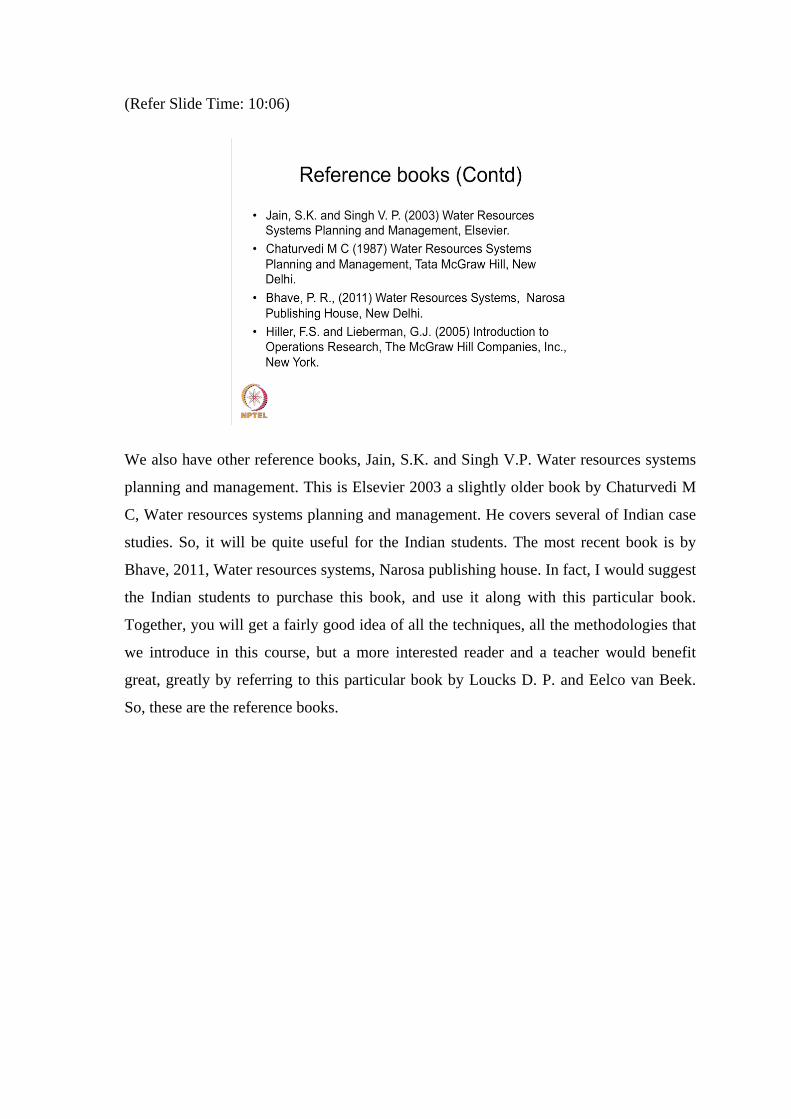
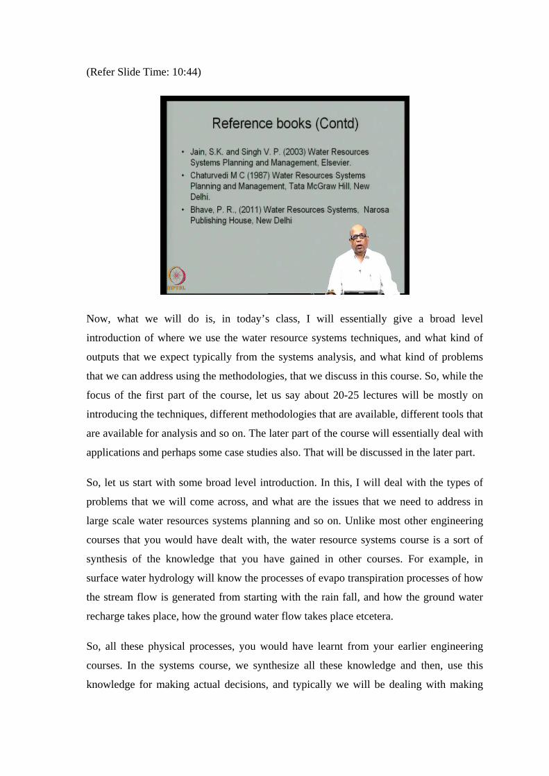
We also have other reference books, Jain, S.K. and Singh V.P. Water resources systems
planning and management. This is Elsevier 2003 a slightly older book by Chaturvedi M
C, Water resources systems planning and management. He covers several of Indian case
studies. So, it will be quite useful for the Indian students. The most recent book is by
Bhave, 2011, Water resources systems, Narosa publishing house. In fact, I would suggest
the Indian students to purchase this book, and use it along with this particular book.
Together, you will get a fairly good idea of all the techniques, all the methodologies that
we introduce in this course, but a more interested reader and a teacher would benefit
great, greatly by referring to this particular book by Loucks D. P. and Eelco van Beek.
So, these are the reference books.
(Refer Slide Time: 10:44)
Now, what we will do is, in today’s class, I will essentially give a broad level
introduction of where we use the water resource systems techniques, and what kind of
outputs that we expect typically from the systems analysis, and what kind of problems
that we can address using the methodologies, that we discuss in this course. So, while the
focus of the first part of the course, let us say about 20-25 lectures will be mostly on
introducing the techniques, different methodologies that are available, different tools that
are available for analysis and so on. The later part of the course will essentially deal with
applications and perhaps some case studies also. That will be discussed in the later part.
So, let us start with some broad level introduction. In this, I will deal with the types of
problems that we will come across, and what are the issues that we need to address in
large scale water resources systems planning and so on. Unlike most other engineering
courses that you would have dealt with, the water resource systems course is a sort of
synthesis of the knowledge that you have gained in other courses. For example, in
surface water hydrology will know the processes of evapo transpiration processes of how
the stream flow is generated from starting with the rain fall, and how the ground water
recharge takes place, how the ground water flow takes place etcetera.
So, all these physical processes, you would have learnt from your earlier engineering
courses. In the systems course, we synthesize all these knowledge and then, use this
knowledge for making actual decisions, and typically we will be dealing with making
optimal decisions. The best decisions, best compromise decisions in the face of conflict,
in the face of randomness, in the face of uncertainty and so on. So, the focus of this
course will be essentially on using all the engineering knowledge to make best decisions.
(Refer Slide Time: 13:45)
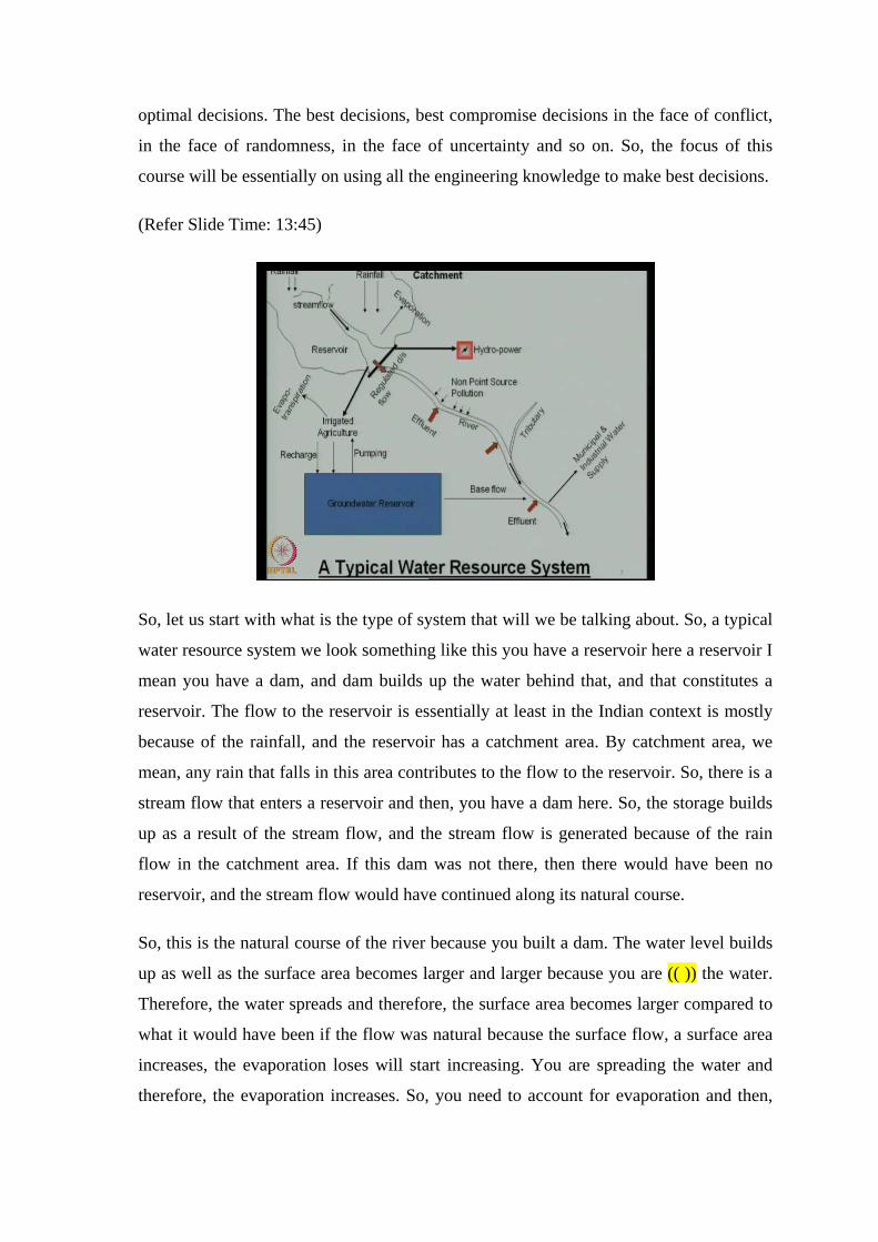
So, let us start with what is the type of system that will we be talking about. So, a typical
water resource system we look something like this you have a reservoir here a reservoir I
mean you have a dam, and dam builds up the water behind that, and that constitutes a
reservoir. The flow to the reservoir is essentially at least in the Indian context is mostly
because of the rainfall, and the reservoir has a catchment area. By catchment area, we
mean, any rain that falls in this area contributes to the flow to the reservoir. So, there is a
stream flow that enters a reservoir and then, you have a dam here. So, the storage builds
up as a result of the stream flow, and the stream flow is generated because of the rain
flow in the catchment area. If this dam was not there, then there would have been no
reservoir, and the stream flow would have continued along its natural course.
So, this is the natural course of the river because you built a dam. The water level builds
up as well as the surface area becomes larger and larger because you are (( )) the water.
Therefore, the water spreads and therefore, the surface area becomes larger compared to
what it would have been if the flow was natural because the surface flow, a surface area
increases, the evaporation loses will start increasing. You are spreading the water and
therefore, the evaporation increases. So, you need to account for evaporation and then,
from the stream flow, you also have infiltration that is taking place (( )) that is taking
place. So, these are the losses from the storage. So, you build a storage reservoir to
essentially store the water for use of different purposes as you created the storage.
There will be losses because of infiltration that goes below the ground, and losses
because of evaporation that water evaporates into the atmosphere. So, we have to
account for these losses. We use these stored water for agricultural use, we use it for
producing hydro power, and we also use it for municipal and industrial demands at the
reservoir as well as from the stream. Therefore, what we generally do is, that from the
reservoir, we take of irrigation canals, we take of (( )) that go through hydro power, and
many times the water that is released into hydropower, subsequently joins the
downstream flow. We also have flows that have directly led into the downstream river.
So, this is the regulated downstream flow from the reservoir by opening the gates or
through the still way it comes and joins the stream flow.
Let us look at what is happening downstream of this. Let us say, you did not have this
dam. Then, the stream flow would have continued, and would have contributed to the
flow downstream of this. As you are going downstream, there is also a natural rainfall
that is contributing to the stream flow here. Now, on the downstream side, there are large
numbers of industries, let us say municipal and industrial effluent.
Effluent is waste discharge that joins the stream. So, there is one effluent here, another
effluent here, another effluent here and so on. Now, these can be industrial and municipal
effluents. These can be treated to certain extent or completely untreated effluents. In
Indian situations, many times we get municipal and industrial treat effluents, which are
not treated to the extent that is desired. Therefore, they (( )) to the pollution of the stream
in addition to these effluents that are shown as point sources. These are called as the
point sources because they join the stream at one location like this.
There is also a non-point source pollutions because of the run off that take place in the
catchment area. As the run off takes place from the rainfall, it may have flown through
agricultural areas, and picked up pesticides fertilizers etcetera. It may also carry sediment
and sediment itself may have been laid with pollutants, and that forms the non-point
source. the essential difference between the point source and the non-point source
pollution is that, this can be controlled. You can have a treatment plant, and control this,

and these can also be estimated fairly accurately, whereas the non-point source pollution
in general cannot be controlled because you do not know exactly from where it is coming
and then, it is hiding all through the length of the stream.
Also many times, it is very difficult to identify the source of the non-point source
pollution itself. It may have horizon because of different sources as I just mentioned.
Then, you may have certain tributaries joining the flow. You may be using the water
from the stream for municipal and industrial supply. You may also lift the water for
irrigation applications and so on. So, apart from usage of the water from the reservoir,
you may also be using the water from downstream flow for various purposes directly
from the stream. You may pump the water and then, use it for irrigation purposes or you
may use it for municipal and industrial water supply and so on.
Then, let us look at the ground water reservoir. So, you have a surface water reservoir
here. You also have a ground water reservoir. From the surface flow, there will be a
recharge that is taking place which can be directly from the rainfall, rainfalls on the
surface soil surface and then, part of it in filtrates and then, part of it may join as
recharge. In addition, whatever water, that apply for agriculture purposes that water part
of it can also go as deeper coalition and then, accounting for the unsaturated zone, you
also may get some recharge from the agriculture water application itself. So, you get
recharge, both from natural rainfall as well as from irrigated agriculture, whatever you
apply for irrigated agriculture. Then, you may be using this ground water for agriculture
purposes or drinking water purposes and so on.
So, there is a pumping that is taking place from the ground water reservoir typically (( )).
So, this balance of the ground water reservoir is also an important component of a water
resource system analysis. So, you may have a flow that is taking place here. There is an
outflow that may eventually join a stream here as base flow. There is a recharge that is
taking place; there is a usage of the ground water taking place and so on. Now, at the
irrigated point itself, irrigation point itself, you may have evapo transpiration taking
place. This is essentially how the crops use the water through evapo transpiration. Now,
the evapo transpiration itself will depend on the soil moisture and therefore, you talk
about another reservoir, soil reservoir.
So, there is a surface water reservoir, there is a ground water reservoir, there is a soil
moisture reservoir. Now, the soil moisture reservoir, again you will do the continuity of
the soil moisture based on how much has been accumulated in the soil moisture, how
much has been taken out by the crops and other vegetation in the form of evapo
transpiration and then, part of it, part of the ground water reservoir also contributes to the
base flow. So, when you are looking at this system as a whole in water resource systems
analysis, it is extremely important for us to look at the system as whole where different
parts, different components are all integrated. So, you touch some components, some
other component will respond. So, that is how you develop an integrated view of the
entire system and then, see how best you can develop, how best you can operate, how
best you can plan for activities. On such a water resource system, often times we may
look at individual components.
For example, in fact, in many situations, we look at individual components. Let say, I
look at only the reservoir operation taking lumping all other systems. So, we may lump
the total demands, we may lump the ground water contribution, or we may ignore the
ground water contribution, we may ignore the water quality (( )) component and so on. I
am simply looking at the reservoir here, look at the total demands; you look at the hydro
power and then, operate the system in an optimal way. On the other hand, you may
ignore this reservoir. Simply look at this downstream, the stream on the downstream and
then, look at the water quality aspects of it how best to maintain the water quality. Yet
another way of doing it is, simply ignore the surface water systems, simply look at the
ground water systems, how much can be a pump to be given, how much is coming as a
recharge, and what kind of fluctuations, ground water level fluctuations that are
happening on this particular (( )) and so on.
So, you can analyze various components separately, or you may have an exercise in
which you would like to have a look at the entire system, and then, optimally operate,
optimally plan for the development of the entire system. So, this is a typical water
resource system. There are many variants of this. For example, you may have several
such reservoirs, you may have ground water reservoir split into 2 or 3 different
reservoirs. You may have agricultural field composing of several different crops partly,
partly you know served by the ground water reservoir, partly served by surface water
reservoir. You may have several different types of effluents, and all the effluents reacting
with each other, not necessarily non-reactive pollutants and so on. So, you may have
different variants of this particular typical water resource system.
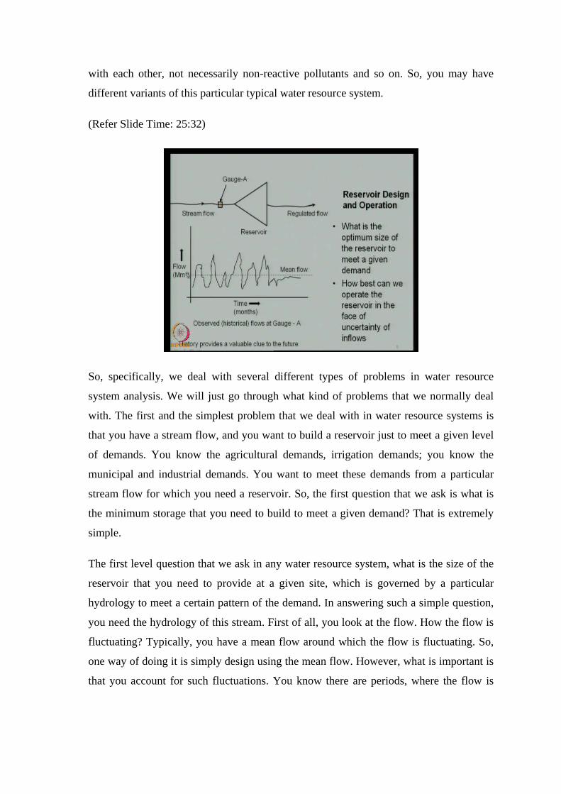
(Refer Slide Time: 25:32)
So, specifically, we deal with several different types of problems in water resource
system analysis. We will just go through what kind of problems that we normally deal
with. The first and the simplest problem that we deal with in water resource systems is
that you have a stream flow, and you want to build a reservoir just to meet a given level
of demands. You know the agricultural demands, irrigation demands; you know the
municipal and industrial demands. You want to meet these demands from a particular
stream flow for which you need a reservoir. So, the first question that we ask is what is
the minimum storage that you need to build to meet a given demand? That is extremely
simple.
The first level question that we ask in any water resource system, what is the size of the
reservoir that you need to provide at a given site, which is governed by a particular
hydrology to meet a certain pattern of the demand. In answering such a simple question,
you need the hydrology of this stream. First of all, you look at the flow. How the flow is
fluctuating? Typically, you have a mean flow around which the flow is fluctuating. So,
one way of doing it is simply design using the mean flow. However, what is important is
that you account for such fluctuations. You know there are periods, where the flow is

very small, and periods where the flow is very large. So, these fluctuations we need to
account for through the reservoir.
Essentially, what does the reservoir do? Reservoir re-distributes the deficits and the
excesses, such that throughout the year, you have a reliable supply of water. That is what
the reservoir does. If let us say, the stream flow is so high compared to the demand, then
there is no need for a reservoir. That means, you can simply (( )) the water directly from
the stream and then, supply to meet the demands. The reservoir becomes necessary; the
storage becomes necessary because the demands are higher than the mean flow. I am
sorry; the demands are higher in terms of the time distribution.
So, when the flow is low, you may require a demand, you may need the water which is
much larger than the flow. Where do you get it from? You derive it from the storage, and
that is why, you build storage. So, storage essentially redistributes the deficits across the
time of a year, such that you will have a reliable amount of water supply. So, we will
study how to get the minimum size of the reservoir.
The second question that we ask is, if you have a reservoir already built and you want to
meet a certain demand pattern, what do I mean by demand pattern, that month to month
the demands are varying, month to month the flows are varying, and you have a given
reservoir already in place. How do we operate this reservoir in the face of uncertainty of
the flows because you need to operate it, not knowing how the future will be? Even
within a year, you do not know exactly how the future will be, and you need to operate
that in the face of uncertainty of inflows. You want to meet the demands, but you do not
know how the flow is like to be in the future, how we operate this.
In all of this, we use the premise that the history provides a valuable clue to the future.
So, we look at the historical data, do all the data analysis that is capable of and then,
derive the knowledge that is inherent in the data, use that knowledge to make these
decisions. This is called as the assumption of stationarity. That is we are saying, that the
way the history has been for this particular stream, the future will be similar to the
history. So, we are saying, history provides a valuable clue to the future. This need not
be always true. In fact, in the context of climate change, the question of stationarity has
been seriously challenged. Therefore, we can no longer assume stationarity. However, I
will come to these topics much later. So, the systems techniques by enlarge assume a
stationarity. So, we rely on making decisions based on the historical data.
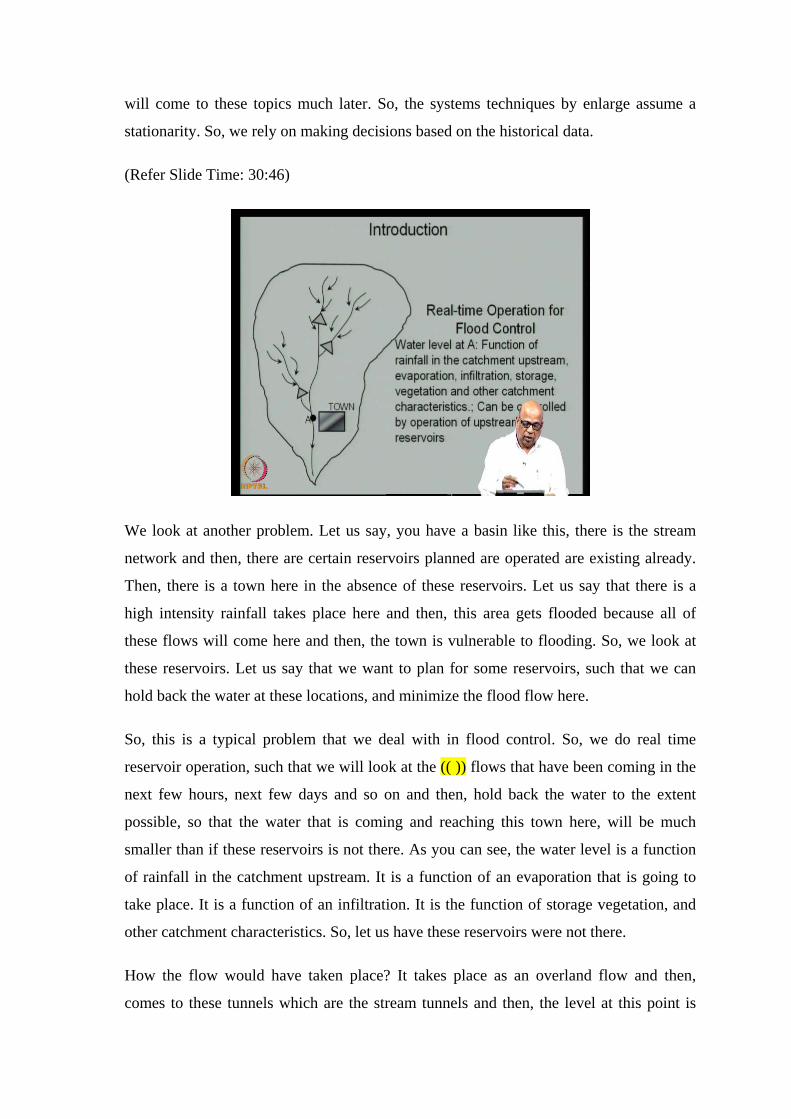
(Refer Slide Time: 30:46)
We look at another problem. Let us say, you have a basin like this, there is the stream
network and then, there are certain reservoirs planned are operated are existing already.
Then, there is a town here in the absence of these reservoirs. Let us say that there is a
high intensity rainfall takes place here and then, this area gets flooded because all of
these flows will come here and then, the town is vulnerable to flooding. So, we look at
these reservoirs. Let us say that we want to plan for some reservoirs, such that we can
hold back the water at these locations, and minimize the flood flow here.
So, this is a typical problem that we deal with in flood control. So, we do real time
reservoir operation, such that we will look at the (( )) flows that have been coming in the
next few hours, next few days and so on and then, hold back the water to the extent
possible, so that the water that is coming and reaching this town here, will be much
smaller than if these reservoirs is not there. As you can see, the water level is a function
of rainfall in the catchment upstream. It is a function of an evaporation that is going to
take place. It is a function of an infiltration. It is the function of storage vegetation, and
other catchment characteristics. So, let us have these reservoirs were not there.
How the flow would have taken place? It takes place as an overland flow and then,
comes to these tunnels which are the stream tunnels and then, the level at this point is
determined by various factors like this, but the water level at this location, or the
discharge at this location can, in fact, the control by properly operating these reservoirs
upstream of this. So, this is what we do in real time operation of reservoirs. So, we look
at all the water levels at various reservoirs and then, make a decision at these locations.
Similarly, we look at the water levels in various reservoirs, as well as what is the current
discharge here, as well as what is the forecasted rain for the next few hours, next few
days and so on and then, make decisions at these locations, such that this town is
protected from floods. This appears to be a simple problem. However, the challenge and
in Indian situation, it is a very true challenge, very realistic challenge is that how much
do we store and how much do we release is the question because the high intensity
rainfalls are in fact bringing large amounts of water. So, an intuition is to store the water,
but as you keep on storing, the storage level builds and there is the question for the
floods is smaller and smaller as the storage level builds.
So, to control, the floods you would like to keep the reservoirs empty. However, you
need the water for the subsequent season. When the floods pass away, you need the
water and therefore, you also want to store the water. So, there is a conflict between the
water usage, and the flood control. So, this conflict we need to address in managing the
water resource systems and this is what we do through systems techniques.
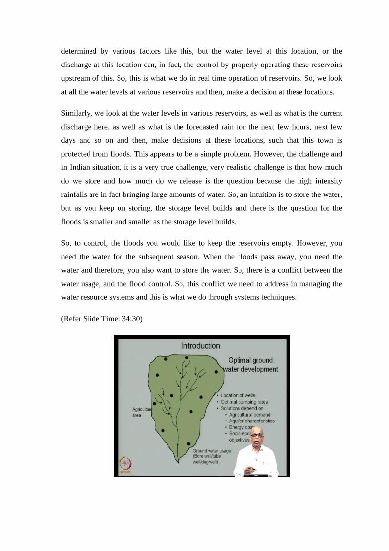
(Refer Slide Time: 34:30)
You look at another typical problem, where you do not have any reservoirs nor do you
plan for any reservoirs. However, there is an adequate ground water available, and you
want to develop the agricultural area. So, you want to supply water for the agricultural
area. So, the question that you would ask is, how do we develop the ground water system
specifically, where all do we use the ground water, that is the location of wells. Now,
these wells can be bore wells, these wells can be tube wells, they can be dug wells,
depending on the type of usage that you have, not only the locations. The locations
themselves will depend on the aquifer characteristics. It depends on the pipe of usage
that you would like to put the ground water too. It depends on the energy cost because
you need to pump the ground water. It also depends on the agricultural demand, what
kind of crops that farmer is growing, what kind of cropping pattern that you would like
to develop, and it also depends on a large number of socio economic objectives.
Now, all of these we should be able to put together and then, make decisions on where
we put this ground water usage points knowing the surface water hydrology, as well as
knowing the aquifer characteristics, knowing the ground water hydrology. How the
ground water levels fluctuate with respect to the usage, as well as with respect to the
rainfall input, as well as with respect to (( )) input and so on. So, we synthesize, we
integrate all of these information and then, arrive at decisions on how much to use on the
ground water, how much to use the surface water.
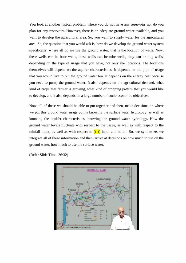
(Refer Slide Time: 36:32)

When there are no storage reservoirs here, we look at some specific large basins, and the
example that I am giving is of the Narmada basin which is the large river basin and it
serves several states, for example Madhya Pradesh, Gujarat, Rajasthan and Maharashtra.
Maharashtra is here, Rajasthan is here, Gujarat and Sardar Sarovar is just in the border
between Madhya Pradesh. As it crosses Madhya Pradesh, you have the Sardar Sarovar
reservoir and this is the large river system. It is a west flowing river system. In such large
river basin systems, you can do very elegant systems analysis to answer several
questions. One is predevelopment questions. What I mean, the predevelopment is that
you have taken up this basin to start using the water at various locations to meet different
demands.
For example, you want to supply water to Rajasthan, which is a desert area which is
water dessert area and you know that you can supply water to Rajasthan through this.
Then, you may want to use the water for irrigation in Gujarat as well as irrigation in
Madhya Pradesh and then, Maharashtra and so on. So, the first question that you will ask
is how much of these demands can be met from the water that is available in this stream
and then, where all you can locate the reservoirs, the storage structures, such that you
will be able to meet the demands. Then, how do we operate these reservoir systems, such
that you will be able to meet the demands to the best extent possible.
However, when we do this large scale river basin systems analysis, we need to keep in
mind that the objectives of development and the objectives of environment protection, as
well as the ecological integrity of the systems, they are often conflicting. So, we need to
look at all these objectives in a holistic manner and then, develop the system, such that
you are able to meet the demands. Yet at the same time, you are able to meet the
integrity, you are able to keep the integrity of the system in time. Both, the environment
ecological integrity as well as the hydraulic integrity and the socio economic system
integrity that you need to keep in mind and then, develop systems for water resource
development.
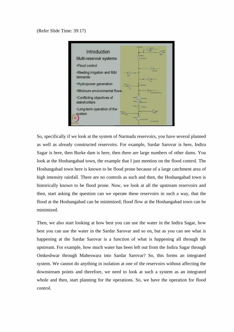
(Refer Slide Time: 39:17)
So, specifically if we look at the system of Narmada reservoirs, you have several planned
as well as already constructed reservoirs. For example, Sardar Sarovar is here, Indira
Sagar is here, then Burke dam is here, then there are large numbers of other dams. You
look at the Hoshangabad town, the example that I just mention on the flood control. The
Hoshangabad town here is known to be flood prone because of a large catchment area of
high intensity rainfall. There are no controls as such and then, the Hoshangabad town is
historically known to be flood prone. Now, we look at all the upstream reservoirs and
then, start asking the question can we operate these reservoirs in such a way, that the
flood at the Hoshangabad can be minimized; flood flow at the Hoshangabad town can be
minimized.
Then, we also start looking at how best you can use the water in the Indira Sagar, how
best you can use the water in the Sardar Sarovar and so on, but as you can see what is
happening at the Sardar Sarovar is a function of what is happening all through the
upstream. For example, how much water has been left out from the Indira Sagar through
Omkeshwar through Maheswara into Sardar Sarovar? So, this forms an integrated
system. We cannot do anything in isolation at one of the reservoirs without affecting the
downstream points and therefore, we need to look at such a system as an integrated
whole and then, start planning for the operations. So, we have the operation for flood
control.

As I said, you may have typical critical locations at various locations; various points in
the system where you would like to have a flood control. You would like to meet the
irrigation, and municipal and industrial demands at various locations, typically at the
reservoirs. You would like to meet the hydro power generation. You want to maximize
the hydro power generation. At various locations, you may have hydro power at Sardar
Sarovar; you may have Indira Sagar and Burke and so on. You would like to maintain
the minimum environmental flows because if you hold up large amount of water, then
the flow downstream of the reservoir that is affected and therefore, you need to maintain
minimum environmental flows. This we will discuss in length, at some length when we
discuss in case studies.
There will be conflicting objective of stake holders. By that I mean, when you construct
a reservoir, the forest may be submerged, the villages may have to be relocated and so
on. Therefore, what is good for irrigation may not necessarily be good from that,
environmental, ecological, socio-economic aspects and so on. So, you have essentially
conflicting objectives of development and therefore, you must have a trade-off and there
are ways of addressing these conflicts and ways of obtaining the best compromise
solutions.
When you have such large number of stake holders, each conflicting with the other, then
you will look at the long term operation of such a system, it is not that just this year
operation, it is not just over the next two years and so on. These systems are supposed to
serve for hundreds of years and therefore, you must be able to arrive at long term
operation of such systems. Now, these can be done elegantly through systems.
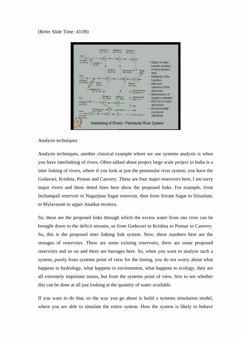
(Refer Slide Time: 43:08)
Analysis techniques
Analysis techniques, another classical example where we use systems analysis is when
you have interlinking of rivers. Often talked about project large scale project in India is a
inter linking of rivers, where if you look at just the peninsular river system, you have the
Godavari, Krishna, Pennar and Cauvery. These are four major reservoirs here, I am sorry
major rivers and these doted lines here show the proposed links. For example, from
Inchampali reservoir to Nagarjuna Sagar reservoir, then from Sriram Sagar to Srisailam,
to Mylavaram to upper Anaikat etcetera.
So, these are the proposed links through which the excess water from one river can be
brought down to the deficit streams, so from Godavari to Krishna to Pennar to Cauvery.
So, this is the proposed inter linking link system. Now, these numbers here are the
storages of reservoirs. There are some existing reservoirs, there are some proposed
reservoirs and so on and there are barrages here. So, when you want to analyze such a
system, purely from systems point of view for the timing, you do not worry about what
happens to hydrology, what happens to environment, what happens to ecology, they are
all extremely important issues, but from the systems point of view, first to see whether
this can be done at all just looking at the quantity of water available.
If you want to do that, so the way you go about is build a systems simulation model,
where you are able to simulate the entire system. How the system is likely to behave

once you put these links with given dimensions, with given gravity flow, pumping flow
combinations of the (( )) and so on. So, when you have the physical system in place, you
reproduce the behavior of the system mathematically on a computer and that is what is
called as a simulation. So, you simply mimick the behavior of the system through
simulation and in doing that, the question that you would be, questions that you would be
interested in answering are the following.
First is extent of water transfer possible in the proposed links. How much water you can
really transfer from this? It is not just physical limitation of the links; it is also the
functional limitation of the various reservoir sectors you have here because the priority
of allocations of water will be first whatever water you have here has to meet its own
requirements. Then, it needs to meet the downstream requirements of the same river and
then, only in excess of that, you will be able to supply to other river systems. So, this
system has to be looked at an integrated whole system and then, you analyze where the
water is flowing from, period to period what level of storage fluctuation are taking place,
what level of demands you are able to meet, what level of hydro power that you are able
to generate and so on.
So, you build a system model and then, answer large number of questions, for example
reliability of the transfers. Let us say, that you in fact build the system. How reliable is
the system, purely even purely based on quantitative aspects. How many times it is able
to meet the demands, then we also look at if we build this interlinking system, what kind
of irrigation potential that you can cater to, how you can maximize the irrigation
potential and so on. Then, we keep in mind the priority of water allocations as I said just
now that you may have priority for water allocation in some of the basin of Godavari,
basin of Krishna, Pennar, Cauvery and so on. So, we may have priorities on usage at
various locations, usage for various purposes, such as agriculture hydro power, flood
control and so on.
So, we look at the entire system and then, arrive at the reliability of the transfers, we
arrive at maximization of irrigation potential keeping in mind the priorities of water
allocation and then finally, we also look at need to look at environmental, ecological
objectives and then, arrive at the intra year operation of the reservoirs to maintain this
kind of transfer for system. So, this is one area, where you can apply your systems
techniques.
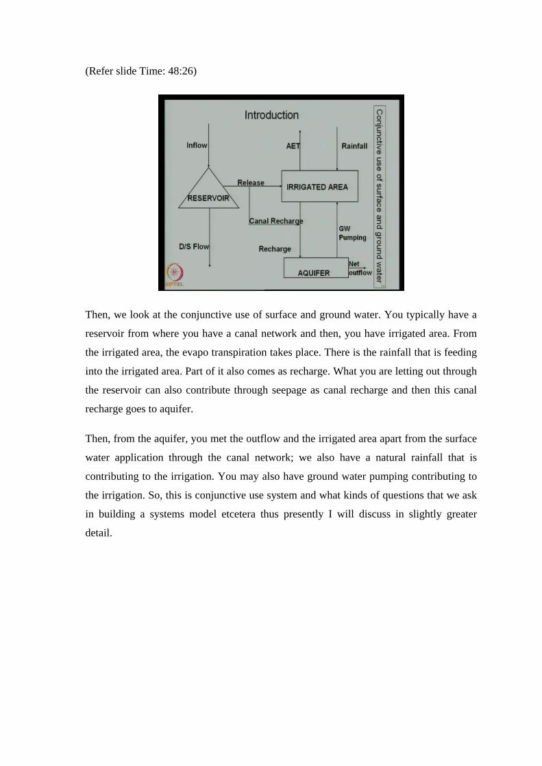
(Refer slide Time: 48:26)
Then, we look at the conjunctive use of surface and ground water. You typically have a
reservoir from where you have a canal network and then, you have irrigated area. From
the irrigated area, the evapo transpiration takes place. There is the rainfall that is feeding
into the irrigated area. Part of it also comes as recharge. What you are letting out through
the reservoir can also contribute through seepage as canal recharge and then this canal
recharge goes to aquifer.
Then, from the aquifer, you met the outflow and the irrigated area apart from the surface
water application through the canal network; we also have a natural rainfall that is
contributing to the irrigation. You may also have ground water pumping contributing to
the irrigation. So, this is conjunctive use system and what kinds of questions that we ask
in building a systems model etcetera thus presently I will discuss in slightly greater
detail.
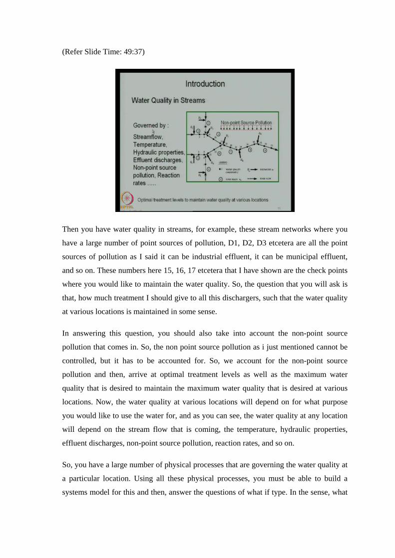
(Refer Slide Time: 49:37)
Then you have water quality in streams, for example, these stream networks where you
have a large number of point sources of pollution, D1, D2, D3 etcetera are all the point
sources of pollution as I said it can be industrial effluent, it can be municipal effluent,
and so on. These numbers here 15, 16, 17 etcetera that I have shown are the check points
where you would like to maintain the water quality. So, the question that you will ask is
that, how much treatment I should give to all this dischargers, such that the water quality
at various locations is maintained in some sense.
In answering this question, you should also take into account the non-point source
pollution that comes in. So, the non point source pollution as i just mentioned cannot be
controlled, but it has to be accounted for. So, we account for the non-point source
pollution and then, arrive at optimal treatment levels as well as the maximum water
quality that is desired to maintain the maximum water quality that is desired at various
locations. Now, the water quality at various locations will depend on for what purpose
you would like to use the water for, and as you can see, the water quality at any location
will depend on the stream flow that is coming, the temperature, hydraulic properties,
effluent discharges, non-point source pollution, reaction rates, and so on.
So, you have a large number of physical processes that are governing the water quality at
a particular location. Using all these physical processes, you must be able to build a
systems model for this and then, answer the questions of what if type. In the sense, what
if I take out this discharger completely, then what happens at the check point here and so
on. So, we must be able to build both systems simulation models as well as systems
optimization models to answer several of these questions.
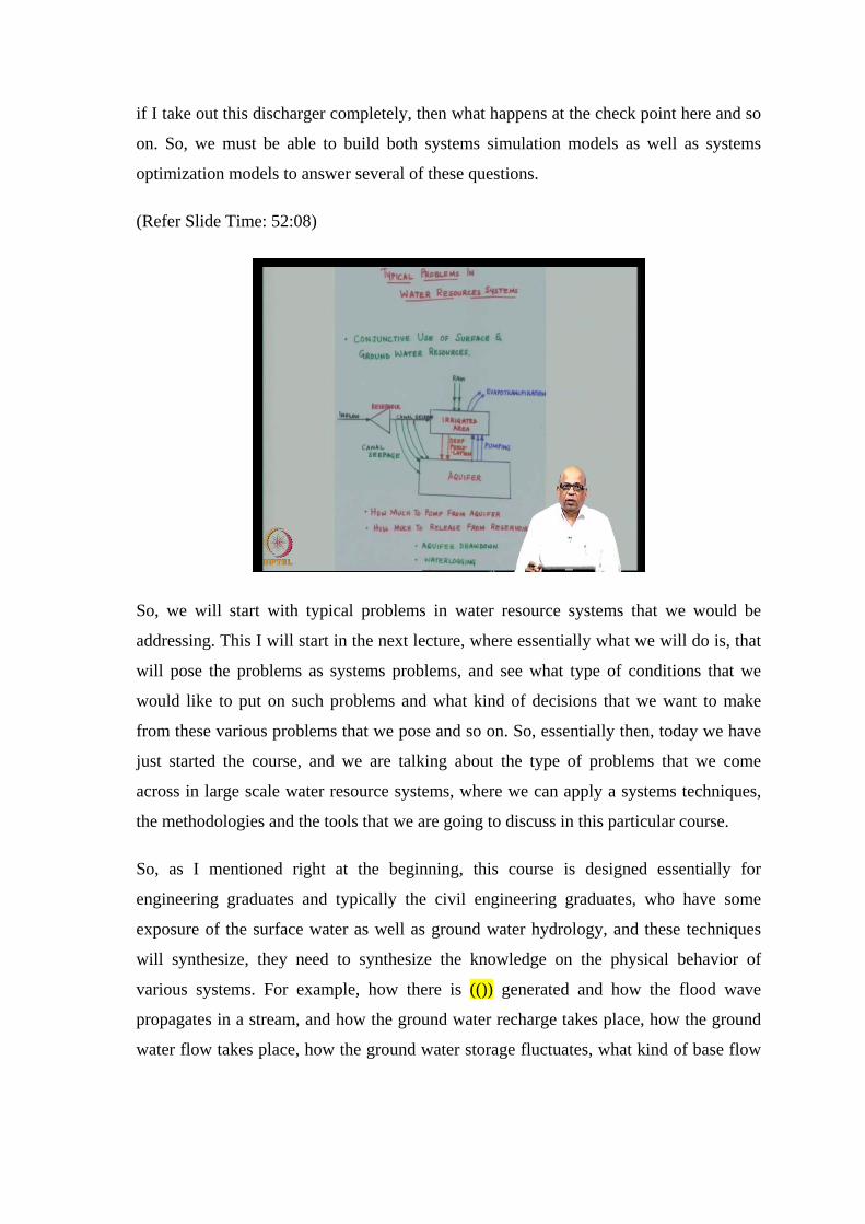
(Refer Slide Time: 52:08)
So, we will start with typical problems in water resource systems that we would be
addressing. This I will start in the next lecture, where essentially what we will do is, that
will pose the problems as systems problems, and see what type of conditions that we
would like to put on such problems and what kind of decisions that we want to make
from these various problems that we pose and so on. So, essentially then, today we have
just started the course, and we are talking about the type of problems that we come
across in large scale water resource systems, where we can apply a systems techniques,
the methodologies and the tools that we are going to discuss in this particular course.
So, as I mentioned right at the beginning, this course is designed essentially for
engineering graduates and typically the civil engineering graduates, who have some
exposure of the surface water as well as ground water hydrology, and these techniques
will synthesize, they need to synthesize the knowledge on the physical behavior of
various systems. For example, how there is (()) generated and how the flood wave
propagates in a stream, and how the ground water recharge takes place, how the ground
water flow takes place, how the ground water storage fluctuates, what kind of base flow

you can expect to the stream etcetera. So, all these which you would have learnt in that
classical hydrology courses will need to be used in the systems analysis.
So, we have gone through the course content, and we have seen some examples of the
systems, water resource systems where such analysis techniques and tools will be useful.
Typically, the large scale water resource systems that I just showed will involve some
surface water reservoirs, and the ground water aquifer. It would be catering to flood
control, it would be catering to hydro power generation, and it will be catering to
irrigation and municipal and industrial demands. At the same time, it has to maintain
downstream water quality.
The downstream water quality itself is governed by how much of stream flow is letting
into from the reservoir, and how much of effluents, industrial effluents that are coming
polluting the river, and where you want to use the water from the downstream river, for
what purpose you would like to use. For example, you would like to use the water again
for irrigation; you may want to use it for municipal water supply and so on. So,
depending on what purpose you want to use, you may want to maintain the water quality
at certain level.
So, this system has to be looked at in an integrated hole and you plan for both, operation
as well a development of the system, such that the integrity of a system is not lost. You
are able to meet all the demands, yet at the same time, you are able to maintain the
system integrity. What I mean by that is, the environment is not badly affected, the
ecology is not badly affected, yet at the same time, you are able to meet the demands.
After all the challenge for the water resource engineers is to make sure that the demands
are met, yet at the same time, you are not affecting the surrounding environment and the
ecology in an adverse manner, in such an adverse manner that it is recoverable.
So, we keep all these in mind and then build systems morals which are essentially
mathematical models, but you take cognisers of various stake holders inputs, from
various stake holders and then, integrate all of them, build systems morals to do what is
best possible for that given water resources system. So, we will continue this discussion
in the next class, where I will again introduce more specifically the type of problems that
will be dealing with. Thank you for your attention. .