Embed Size (px)
Citation preview
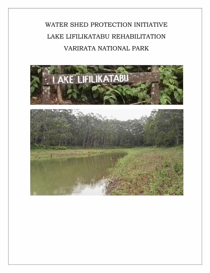
WATER SHED PROTECTION INITIATIVE
LAKE LIFILIKATABU REHABILITATION
VARIRATA NATIONAL PARK
UNDPPARTNERSHIP|WATERSHEDPROTECTIONINITIATIVE,VARIRATANAT.PARK -2-
TableofContents
I LocalityMap 31.0 Introduction 42.0 CurrentSituation 53.0 ProjectIntent 54.0 SiteSpecificData 6-85.0 ExecutionPlan 86.0 Deliverables&ReplenishmentBenefits 9-117.0 StakeholdersandBeneficiaries 118.0 ProjectSustainability 119.0 FinancialProposal 1210.0 ProgramofWorks 1311.0 ProjectManagement&Administration 14Annex–A-Photographs 15–16GeneralData,PrecipitationtoWaterShedProtectionInitiative 17-26
UNDPPARTNERSHIP|WATERSHEDPROTECTIONINITIATIVE,VARIRATANAT.PARK -3-
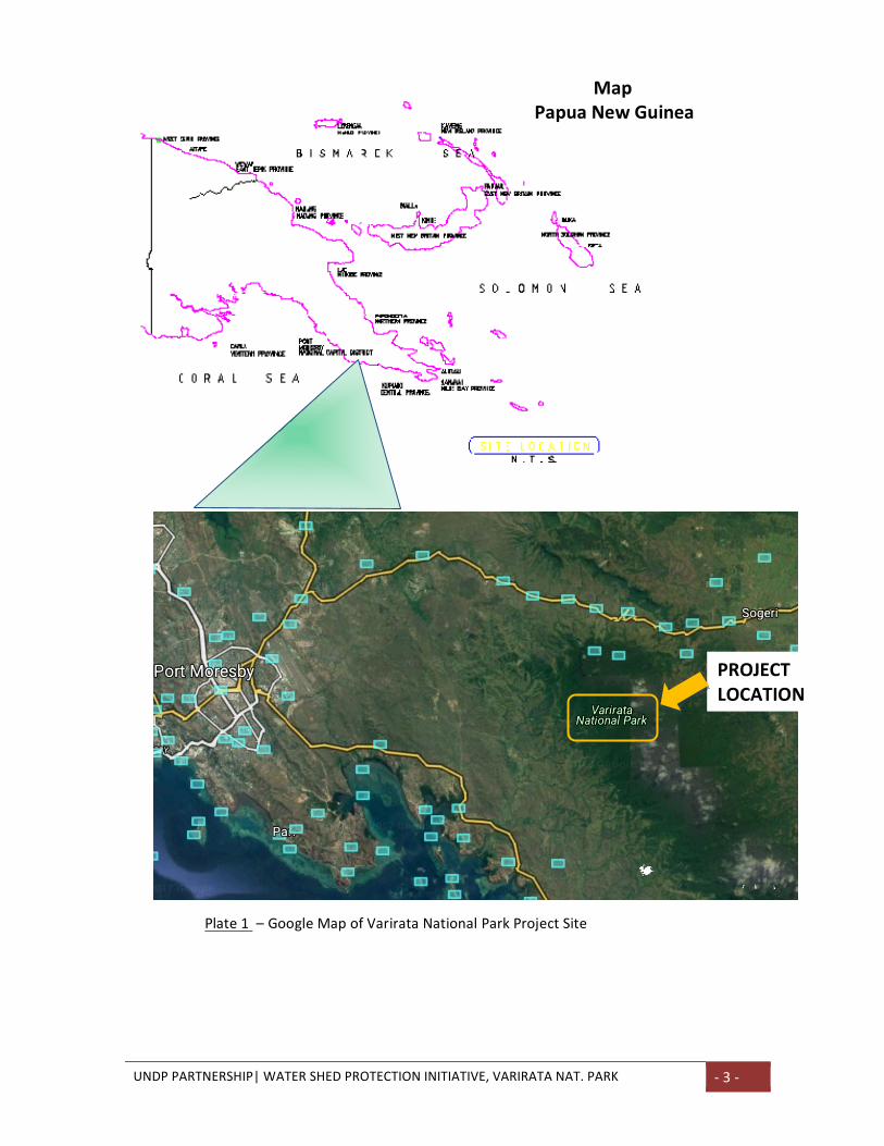
PROJECT
LOCATION
Plate1–GoogleMapofVarirataNationalParkProjectSite
MapPapuaNewGuinea
UNDPPARTNERSHIP|WATERSHEDPROTECTIONINITIATIVE,VARIRATANAT.PARK -4-
1.0INTRODUCTION
WaterShedProtectionProject–AtLakeLifilikatabu,VarirataNationalPark(VNP),SogeriCP
Thedegree,towhichwaterprecipitates,hitstheground,runsoffandinfiltratesintogroundorflows
directlyintowaterwaystoreachtheoceansandthenevaporatesintotheatmospheretorepeatits
cycleisbasicallythedynamicsofnaturalhydrologicalcycle.Inthecontextofthisinitiative,asupply
sideexistswithinthegroundwaterreservoiroftheVNPwhilethedemandsideexistsatthelower
dischargeendofthewatershedarea.Naturallypeoplebuildcommunitiesnearwatersourceswhich
areusuallyatthetransitionalzoneoratthedischargeendsofwatershedareas.
Inthisscenario,thecommunitieslocatedontheTransitionalzoneareRauna1&2,Rauna3&4while
the17Mileto14Mile,9MileandLowerLalokiareasarelocatedontheDischargezoneofthisWater
ShedModel.CommunitieslocatedalongtheTransitionalzonehavelimitedspaceforagricultureor
farmingduetotheruggedandsteepterrainandoccurrencesofmassivebasaltbouldersandhard
rocky surfaces. This condition provides favourable permeability for aquifers and stream flows as
evidentfromroadsidestreamflows.CommunitiesatthelowerDischargezoneenjoysfavourable
expanseofgrazingland,agriculturalfarminglandwheresoilremainsrelativelymoistalmostallyear
roundduetotheircloseproximitytotheLalokiRiverSystem.
TheVNP receives very good rainfall of over 2,000mm/yrwith an average annual temperatureof
24.4°C at the height of 800m ASL. This climatic condition makes it less susceptible for rapid
evaporationfromopenlakesystemandevapotranspirationfromvegetationandexposedsoil.
TheevidenceofnaturalaquiferswithinRecharge,TransitionalZonesandtheeverflowingLalokiRiver
Systemwithin the lowerDischargeSideare clear indicatorsof theexistenceof awater reservoir
located at a higher altitude. More so the evidence of natural stream flows and river systems
originating from the massive belt of basalt rock formation within the VNP further suggest the
abundanceofthisrenewablewatersourcelocateddeepwithintheVNProckformation.
OneofthemostspectacularnaturalformationswithintheVNPisthetwinnaturallakesystemwhich
isseparatedbya15meterwidenaturaldyke;withonelakesystemapproximately500mmabovethe
other.Thisnaturalphenomenonallowstheebbingofhigherlakesystemtorechargeandthelower
lakesystemandwhenthissystemreachesitsoverflowlimit,itspillsoverintothenaturaldrainage
systemanddischargesintothestreamsandriversfurtherbelow.
Byunderstandingthenaturalenvironmentandhabitatof this lakesystemandthefragileaquatic
ecosystemitsupports;atthewater-air interface, lake-floorenvironmentaswellasunderstanding
the geological infiltration potential of the lake’s base stratum, an intervention protocol geared
towardsmaximisingwaterretentioncouldbedeveloped.
Therefore the objective of this Project is to increase the lake retention volume, build hydraulic
pressurewithinthelaketopromotegoodsoilinfiltrationandultimatelyincreasetheunderground
waterstoragecapacityofthegroundwaterreservoir.TheScopeoftheexercisewillbelimitedto
dredgingandde-sludgingthelakefloorfromconsolidatedmud,sandy-siltsludgeandtreebranches
andvegetationdebristhathaveaccumulatedonthelakeflooroveraverylongperiod.
UNDPPARTNERSHIP|WATERSHEDPROTECTIONINITIATIVE,VARIRATANAT.PARK -5-
2.0CURRENTSITUATION–LAKESYSTEM
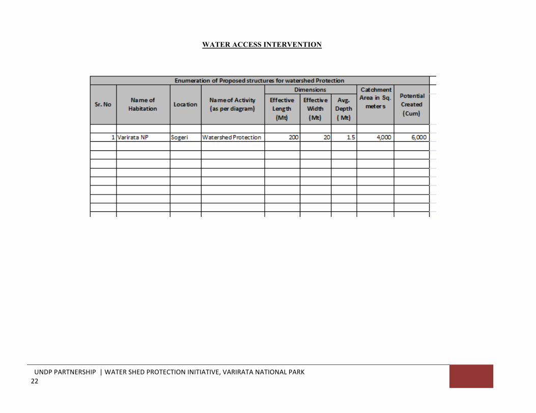
Thecurrentsituationisthattheentiretwinlakesystemshavebuilt-upsludgelevelswithin500mm
belowtheirwater-airinterface.Thesludgedepthextends1.5mbelowthe500mmsludgeleveland
thisequatestototalsludgevolumeofV=1.5mDx200mLx20mW=6,000sq.m,thetotalcombined
lakevolumetobecreatedwithinthisprojectscope.
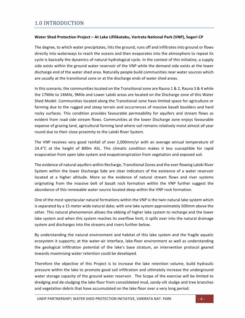
Plate1.PhotoofoneoftheLakeSystem:
3.0PROJECTINTENTTheIntentistoincreasethetotalvolumeofthecombinedlakesystemadequatetoaccommodate
6,000cubicmetersoffreshwaterwhichshouldbeavailableat itsmaximumlevelduringthehigh
precipitationperiodsfromDecembertoApril.
DuringthelowprecipitationperiodfromMaytoNovember,itisexpectedthatthelakevolumewill
decreaseby30–50%ofitstotalholdingload,thusallowingamoderategroundwatermovement.
Thisisnecessarytokeepthesoilporesopenuntilfullcirculationresumeswhenmoreprecipitation
occurs.
Theprojectimplementationstrategywillcompriseofamechanisedoperationmethodologywherea
stringentsiteoperationprotocolwillbeemployedtoensureminimumharmtotheenvironment.
Agencyresponsiblefortheparkshallmonitoralloperationalaspectsduringthecourseoftheproject
implementationperiod.
UNDPPARTNERSHIP|WATERSHEDPROTECTIONINITIATIVE,VARIRATANAT.PARK -6-
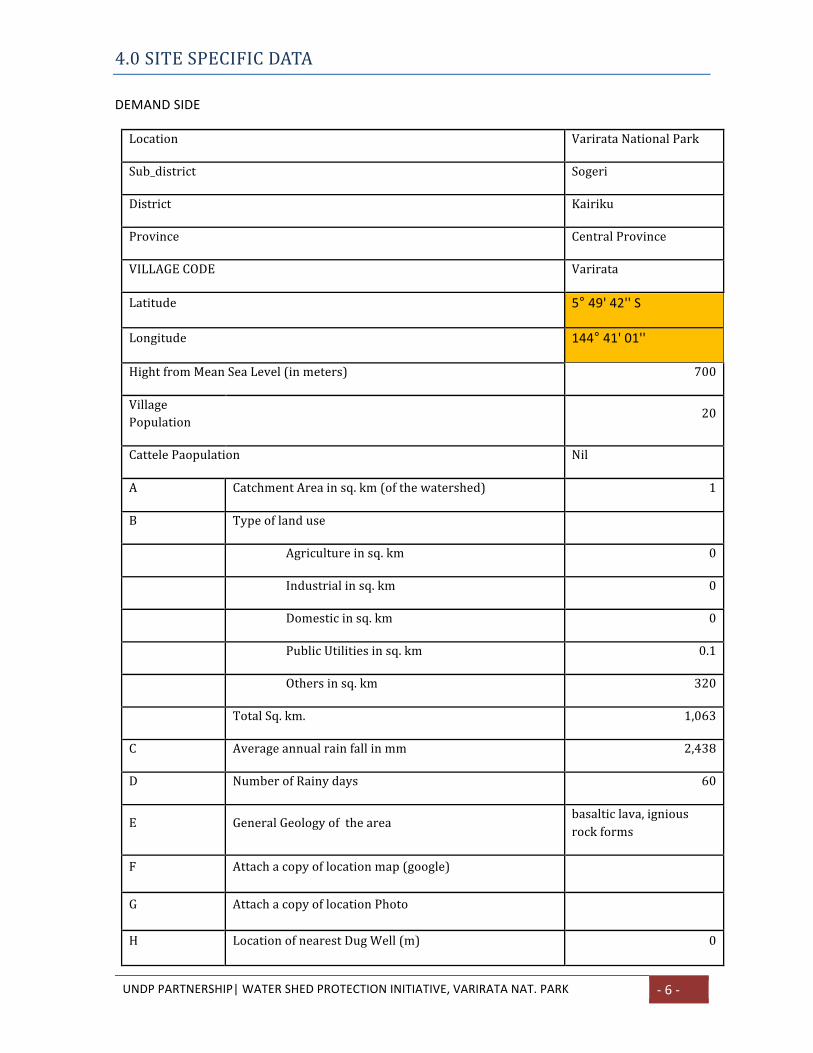
4.0SITESPECIFICDATA
DEMANDSIDE
Location VarirataNationalPark
Sub_district Sogeri
District Kairiku
Province CentralProvince
VILLAGECODE Varirata
Latitude 5°49'42''S
Longitude 144°41'01''
HightfromMeanSeaLevel(inmeters) 700
VillagePopulation 20
CattelePaopulation Nil
A CatchmentAreainsq.km(ofthewatershed) 1
B Typeoflanduse
Agricultureinsq.km 0
Industrialinsq.km 0
Domesticinsq.km 0
PublicUtilitiesinsq.km 0.1
Othersinsq.km 320
TotalSq.km. 1,063
C Averageannualrainfallinmm 2,438
D NumberofRainydays 60
E GeneralGeologyofthearea basalticlava,igniousrockforms
F Attachacopyoflocationmap(google)
G AttachacopyoflocationPhoto
H LocationofnearestDugWell(m) 0
UNDPPARTNERSHIP|WATERSHEDPROTECTIONINITIATIVE,VARIRATANAT.PARK -7-
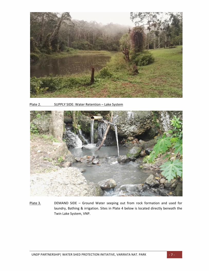
Plate2. SUPPLYSIDE:WaterRetention–LakeSystem
Plate3. DEMAND SIDE – Ground Water seeping out from rock formation and used for
laundry,Bathing&irrigation.SitesinPlate4belowislocateddirectlybeneaththe
TwinLakeSystem,VNP.
UNDPPARTNERSHIP|WATERSHEDPROTECTIONINITIATIVE,VARIRATANAT.PARK -8-
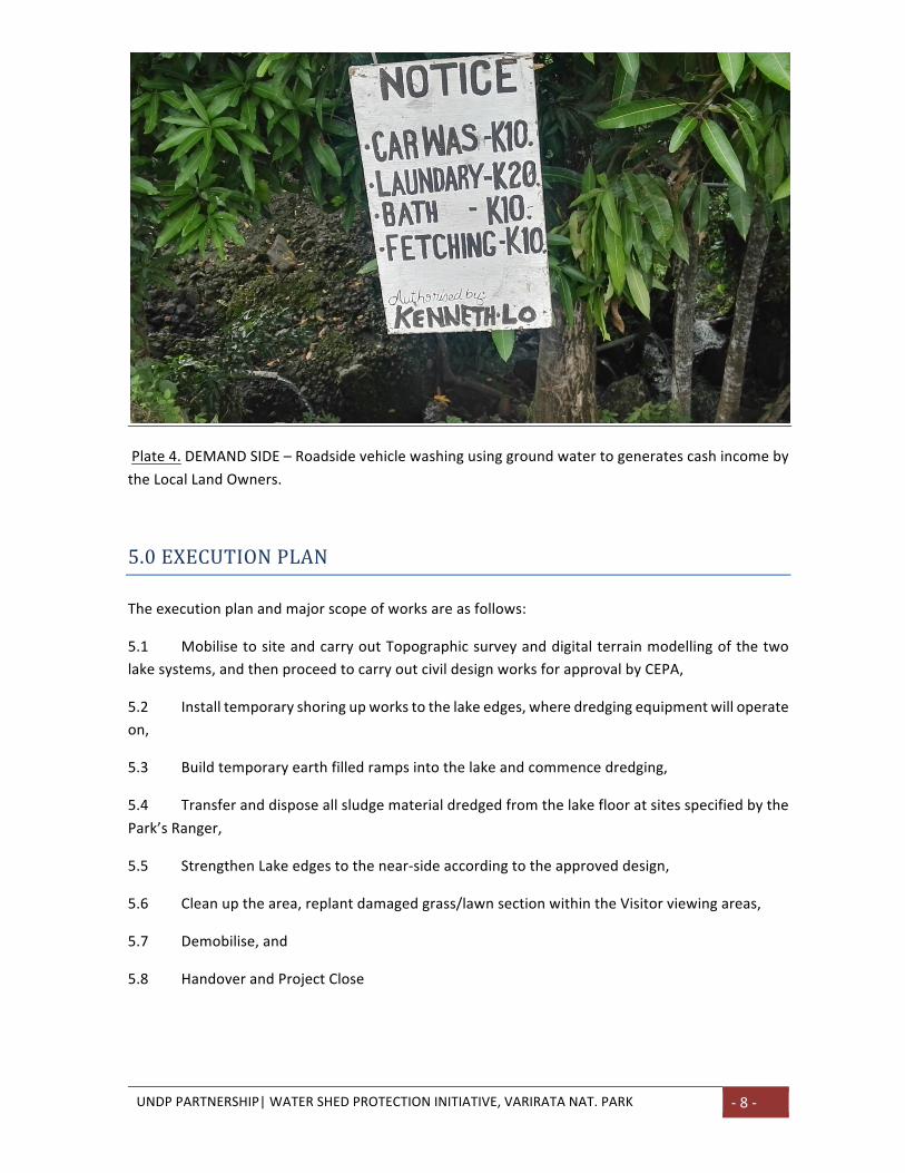
Plate4.DEMANDSIDE–Roadsidevehiclewashingusinggroundwatertogeneratescashincomeby
theLocalLandOwners.
5.0EXECUTIONPLAN
Theexecutionplanandmajorscopeofworksareasfollows:
5.1 MobilisetositeandcarryoutTopographicsurveyanddigitalterrainmodellingofthetwo
lakesystems,andthenproceedtocarryoutcivildesignworksforapprovalbyCEPA,
5.2 Installtemporaryshoringupworkstothelakeedges,wheredredgingequipmentwilloperate
on,
5.3 Buildtemporaryearthfilledrampsintothelakeandcommencedredging,
5.4 Transferanddisposeallsludgematerialdredgedfromthelakeflooratsitesspecifiedbythe
Park’sRanger,
5.5 StrengthenLakeedgestothenear-sideaccordingtotheapproveddesign,
5.6 Cleanupthearea,replantdamagedgrass/lawnsectionwithintheVisitorviewingareas,
5.7 Demobilise,and
5.8 HandoverandProjectClose
UNDPPARTNERSHIP|WATERSHEDPROTECTIONINITIATIVE,VARIRATANAT.PARK -9-
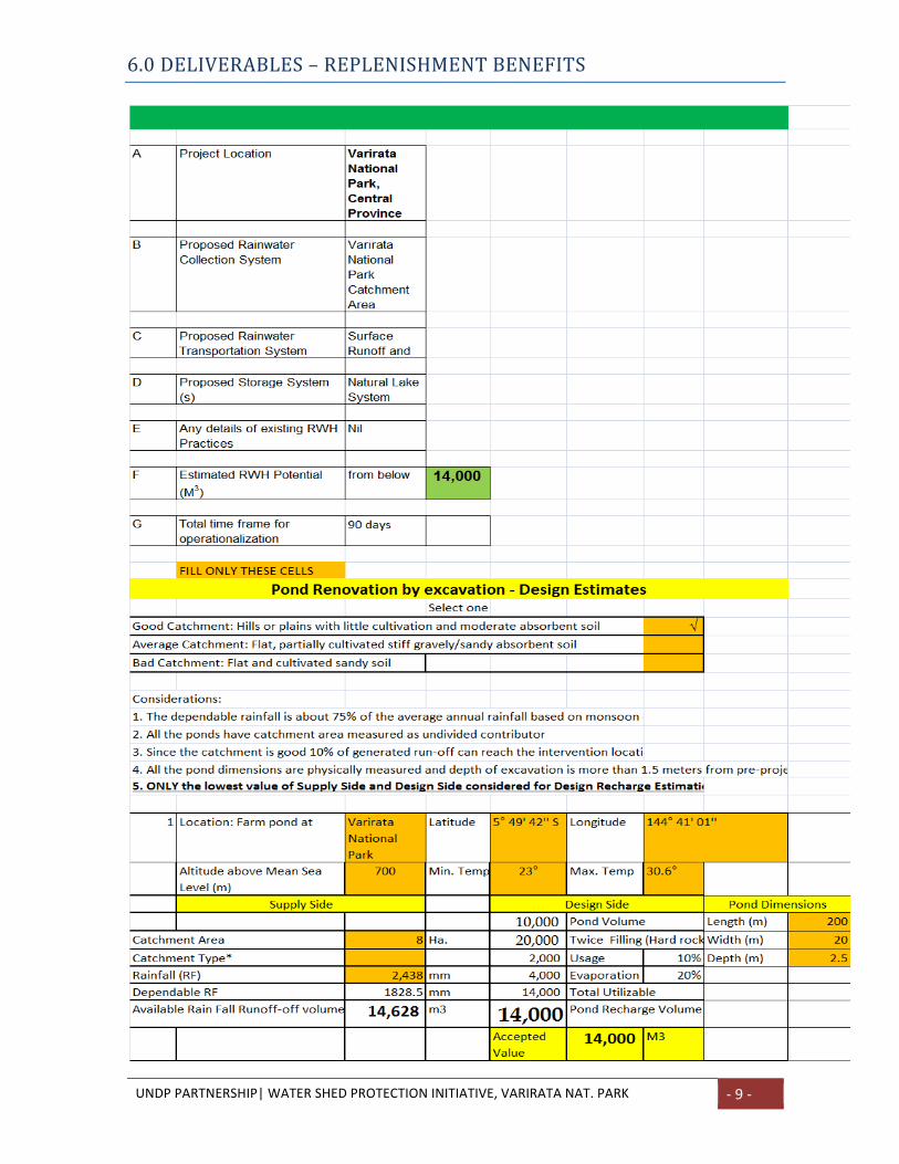
6.0DELIVERABLES–REPLENISHMENTBENEFITS
UNDPPARTNERSHIP|WATERSHEDPROTECTIONINITIATIVE,VARIRATANAT.PARK -10-
ThedeliverablesandtheDemandSideareasfollows:
1. Increasedlakeretentionvolumeby300%fromthecurrentestimatesof2,000cubicmeters
to 6,000 cubicmeters. This will result in increased hydraulic pressure exerted on the lake floor
creatingnewflowlinesinthesoilporesandmoresoopeningupcloggedflowlinesandultimately
rechargingthegroundwaterreservoir.
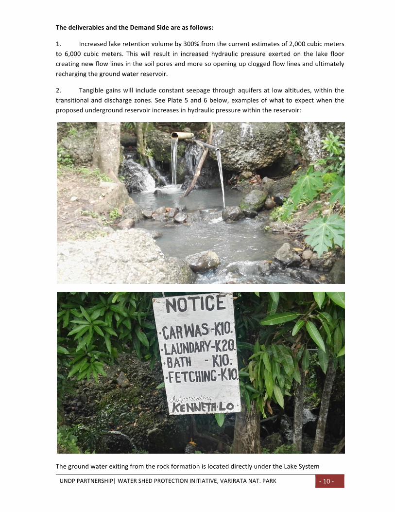
2. Tangiblegainswill includeconstant seepage throughaquifersat lowaltitudes,within the
transitionalanddischargezones.SeePlate5and6below,examplesofwhat toexpectwhenthe
proposedundergroundreservoirincreasesinhydraulicpressurewithinthereservoir:
ThegroundwaterexitingfromtherockformationislocateddirectlyundertheLakeSystem
UNDPPARTNERSHIP|WATERSHEDPROTECTIONINITIATIVE,VARIRATANAT.PARK -11-
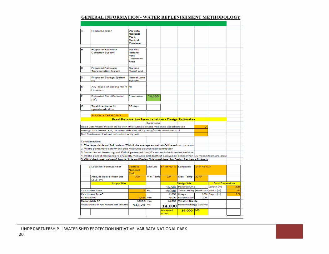
3. The calculatedPotential LakeRetentionVolumeper year is 14,000 cubicmeters of fresh
renewablewater.
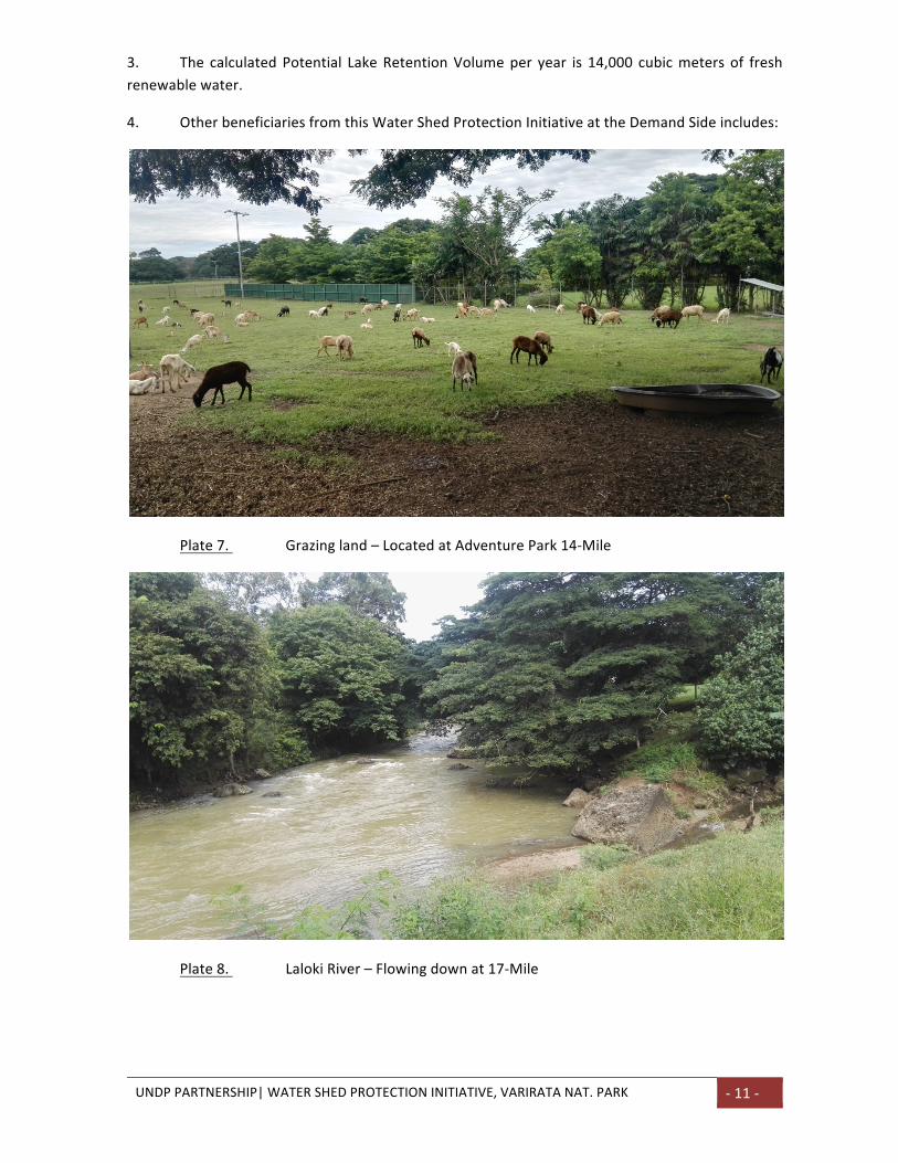
4. OtherbeneficiariesfromthisWaterShedProtectionInitiativeattheDemandSideincludes:
Plate7. Grazingland–LocatedatAdventurePark14-Mile
Plate8. LalokiRiver–Flowingdownat17-Mile
UNDPPARTNERSHIP|WATERSHEDPROTECTIONINITIATIVE,VARIRATANAT.PARK -12-
7.0STAKEHOLDERS&BENEFICIARIES
Stakeholderstothisprojectare:
7.1 ConservationandEnvironmentProtectionAuthority(CEPA),
7.2 LocalandInternationalVisitorstotheVarirataNationalPark,
7.3 Local population of Varirata, Sogeri, and Koiari (The Local Land-Owners) people
withintheTransitionalandDischargeZonesofthisWaterShed,and
7.4 ThePortMoresbyCityResidents.
8.0PROJECTSUSTAINABLITY
Renewable Fresh water retained within the underground reservoir is safe from evaporation,
pollution, contamination from industrial activities and from any uses other than for human and
livestockconsumptionandforsoilmoistureandvegetationgrowth.
As the lake system acts as a natural conduit to transfer surface precipitation into the safe
undergroundstorageforfutureuse,thisconduitmustremainfunctionaltoservethisverypurpose
forthelonghaul.
CEPAwithitsnewmandatewillembracethisinitiativeandmovefurthertofeaturethisnewproduct
locallyandinternationallytoattractmorescenictourism,birdwatchersandotherssothattheybring
inforeignexchangetosustainthecontinuedupkeepofthismagnificentlakesystem.
ThecurrentVNPvisitorfeesare;NationalTouristK2/person,ExpatriateTouristK5/person.Withthe
inclusionofthisnewProduct,‘Therehabilitatedtwinlakesystem’andagoodmarketingstrategyin
place,costrecoveryonthisinvestmentwithintheshorttimeframeispromising.
.
9.0FINANCIALPROPOSAL
FinancialProposal–UsingAnnex2Conlytoprovidequotation.Notenomajorchangeispermitted.
10.0PROGRAMOFWORKS
TheProgramofWorkstobedetailedinMSProjectforclarity.
UNDPPARTNERSHIP|WATERSHEDPROTECTIONINITIATIVE,VARIRATANAT.PARK -13-
Table 2. Program of Works Procurement of Materials 5d Mobilising and Site Establishment 2d Topographic and DTM Survey 3d Implement Shoring Up activities 3d Commence clearing and dredging of lake floor 30d Strengthening lake shore line 5d Replacing & Replacing damaged lawn within lake 3d Clean up and demobilise 1d Hand over and Project Close 0d Totalprojectdurationis35xdays,startingfromthedatewhensiteclearingcommences.
AdditionalactivitieswithregardstoProjectHandoverCeremonywillbeprovidedseparatelyasitis
notpartoftheWorksProgram.
11.0 PROJECTMANAGEMENT&ADMINISTRATION
UNDPwillmanagedtheProjectfrominceptionthroughtocompletionandhandoverwithtechnical
support from the locally engaged Engineer who will oversee the overall technical aspect of the
projectincludingliaisingwithappropriatelocal,privateentitiesandGovernmentAgencies.
12.0REQUIREDQUALIFICATION,SKILLSANDEXPERIENCEOFTHETEAM
The implementation team should include at minimum the following key professionals – TeamLeader/ProjectManager,Hydrologist,Civil/StructuralEngineerandGISSpecialist.Thequalificationslistedforeachspecialistaregivenasanorientationoftheminimumcompetenciesbuttheevaluationteamwillconsider,whenjustifiedaccordingtothemethodologyproposedandothersuggestionsfortheOfferor.
a) RequiredInformationfromPotentialBidders
• ProvideCompanyProfileandprofileofProjectDirector/Owner,• Provideevidenceofpastexperiencesinsimilarprojectscopingundertakenwithinthelast
fiveyears,• ProvidelistingofKeyPersonnelandlistingofmajorpiecesofequipmentincludingage,
ownershipandoperatingweight,and• Methodologyonhowtoimplementtheproject.
b) Demonstratedknowledgeinareasof:
• Siteclearing,dredging,excavation&haulageofsaturatedsludgematerialscomprisingsofttostickysiltymudanddecayingmattersfromnaturallakefloors,
• InstallationofLakeembankmentretainingrock-wallstructure,• Concretefootpathworksandassociatedwalkwayswithinthelakeembankment,• Experienceinbathymetric/hydrographicsurveyingandtopographic/DTMsurveying,
UNDPPARTNERSHIP|WATERSHEDPROTECTIONINITIATIVE,VARIRATANAT.PARK -14-
• Highlevelofcommunicationskills,workprogress/statusreporting,• HighlevelofOccupationalHealthandSafety(OHS)atProjectSite,• AdherencetoCEPAAdviseonminimumdestructiontosoilsurface,floraandfaunawithin
theprotectedNationalParkprojectsite,• Engage/Promotelocalvillageparticipationonlabourintensivetasksandminimiseuseof
heavyequipment,thusminimisingcollateraldamagetoenvironment,• HighlevelofRiskMitigationskillsforworkengagementswithinenvironmentandculturally
sensitiveareas.
c) TeamLeader/ProjectManager
Theteamleader/projectmanagerisexpectedtopossessthefollowing:
• MasterDegreeinSciences,Managementorrelatedfield(PhDisanadvantage);• Atleast10yearsofprojectmanagementexperience;• A good understanding and experience on water issues and construction of water supportsystems including emerging challenges of environment and climate change impacts, andcommunitydevelopment;
• Proven organizational, interpersonal and communication skills needed for effective teammanagementandcoordination;
• Strong record including experiences in selection, mobilisation and monitoring delivery ofconstructiondeadlines;
• Abilitytoworkunderpressureinadifficultmulti-culturalenvironmentonawiderangeoftasksanddeliveryqualityoutputsontime;and
• FluencyinspokenandwrittenEnglishisarequirement.
d) Hydrologist
• BachelorDegreeinhydrologyorrelated(Mastersisanadvantage);• Atleast7yearsofexperienceinhydrologyassessments;• A good understanding of climate change impacts, environmental issues and communitydevelopment;
• Experience in working on development projects that encompasses resource use andmanagementinvolvinggenderconsiderationandlandownermanagement;
• Abilitytoworkunderpressureinadifficultmulti-culturalenvironmentonawiderangeoftasksanddeliveryqualityoutputsontime;
• Goodinterpersonalskillsandabilitytocommunicate;and• FluencyinspokenandwrittenEnglishisarequirement.
e) Civil/StructuralEngineer
• Bachelor Degree in Engineering with at least 7 years of experience in Civil/StructuralEngineering(Mastersisanadvantage);
• A good understanding of climate change impacts, environmental issues and communitydevelopment;
• Experience in working on development projects that encompasses resource use andmanagementinvolvinggenderconsiderationandlandownermanagement;
• Abilitytoworkunderpressureinadifficultmulti-culturalenvironmentonawiderangeoftasksanddeliverqualityoutputsontime;
• Demonstratedknowledge,skillsandexperienceinresearch,conductinganalysisandreportingwriting;
UNDPPARTNERSHIP|WATERSHEDPROTECTIONINITIATIVE,VARIRATANAT.PARK -15-
• Goodinterpersonalskillsandabilitytocommunitytocommunicate;and• FluencyinspokenandwrittenEnglishisarequirement;
f) GISSpecialist
• BachelorDegreeinGeography,Geology,ITorrelatedfields(Mastersisanadvantage);• Atleast7yearsofmapping,GISandRemoteSensingExperience;• A good understanding of climate change impacts, environmental issues and communitydevelopment;
• Experience and knowledge of products and tools of GIS for Landuse Planning andestablishmentofwatersupplysystems;
• Abilitytoworkunderpressureinadifficultmulti-culturalenvironmentonawiderangeoftasksanddeliverqualityoutputsontime;
• Goodinterpersonalskillsandabilitytocommunitytocommunicate;and• FluencyinspokenandwrittenEnglishisarequirement;
Languagerequirements
• FluencyinwrittenandspokenEnglishandTokPisin.
UNDPPARTNERSHIP|WATERSHEDPROTECTIONINITIATIVE,VARIRATANAT.PARK -16-
ANNEX–A-to
ProjectReport1
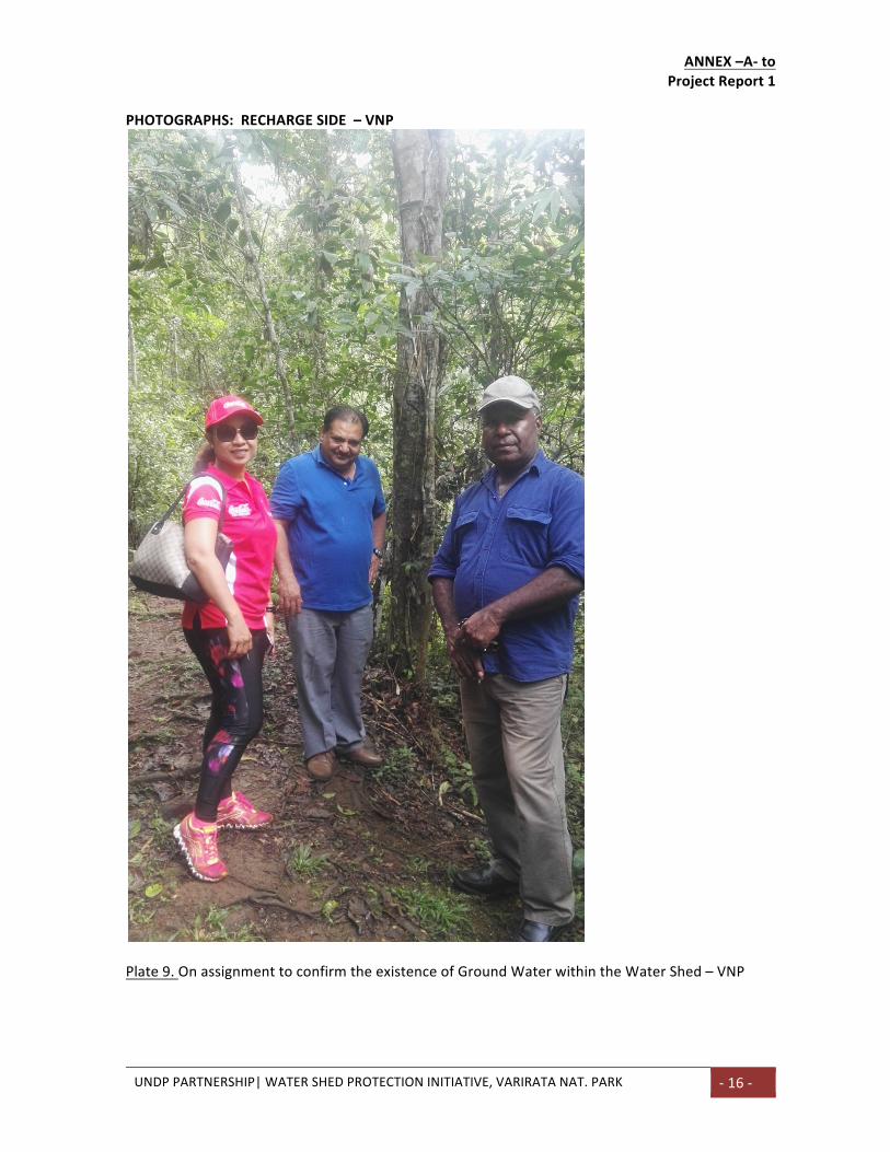
PHOTOGRAPHS:RECHARGESIDE–VNP
Plate9.OnassignmenttoconfirmtheexistenceofGroundWaterwithintheWaterShed–VNP
UNDPPARTNERSHIP|WATERSHEDPROTECTIONINITIATIVE,VARIRATANAT.PARK -17-
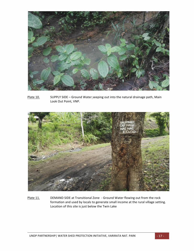
Plate10. SUPPLYSIDE–GroundWaterseepingoutintothenaturaldrainagepath,Main
LookOutPoint,VNP.
Plate11. DEMANDSIDEatTransitionalZone-GroundWaterflowingoutfromtherock
formationandusedbylocalstogeneratesmallincomeattheruralvillagesetting.LocationofthissiteisjustbelowtheTwinLake
UNDPPARTNERSHIP|WATERSHEDPROTECTIONINITIATIVE,VARIRATANATIONALPARK18
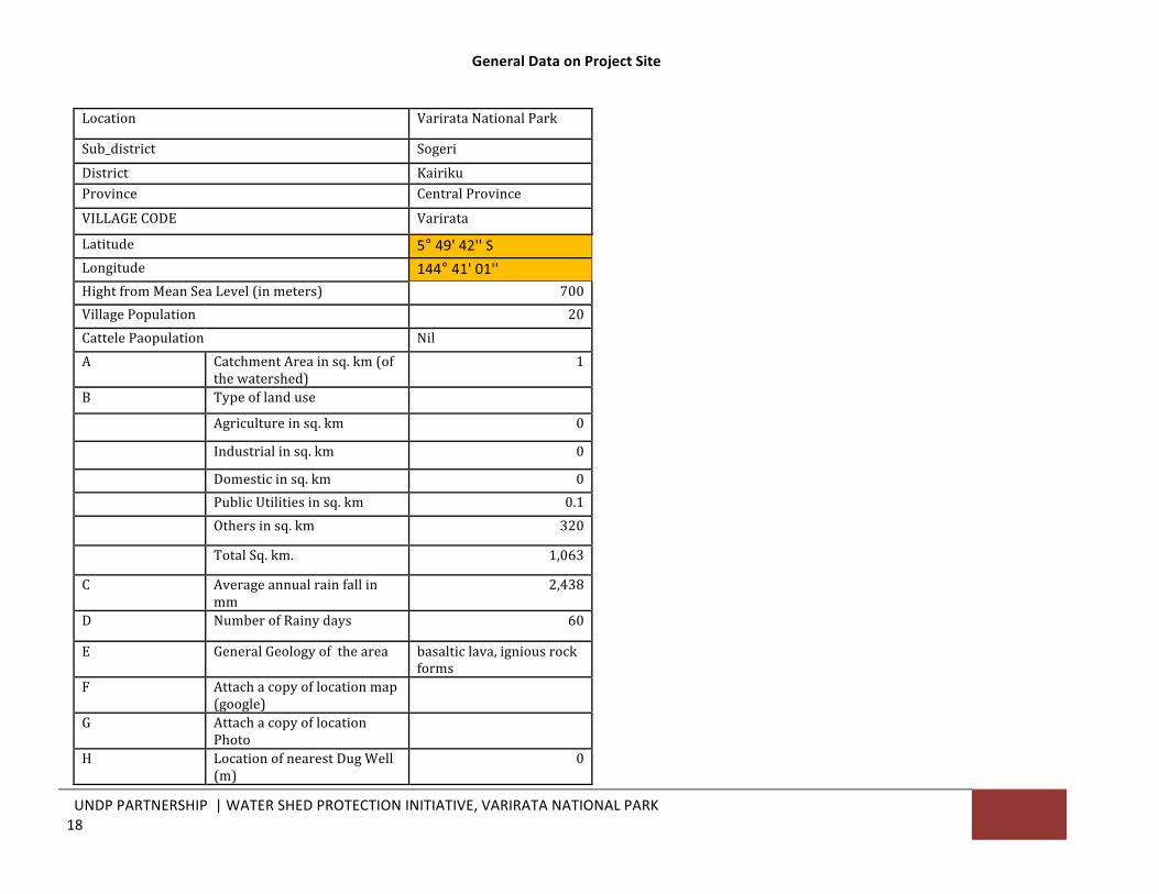
GeneralDataonProjectSite
Location VarirataNationalPark
Sub_district SogeriDistrict KairikuProvince CentralProvince
VILLAGECODE Varirata
Latitude 5°49'42''SLongitude 144°41'01''HightfromMeanSeaLevel(inmeters) 700VillagePopulation 20CattelePaopulation NilA CatchmentAreainsq.km(of
thewatershed)1
B Typeoflanduse
Agricultureinsq.km 0
Industrialinsq.km 0
Domesticinsq.km 0 PublicUtilitiesinsq.km 0.1 Othersinsq.km 320
TotalSq.km. 1,063
C Averageannualrainfallinmm
2,438
D NumberofRainydays 60
E GeneralGeologyofthearea basalticlava,igniousrockforms
F Attachacopyoflocationmap(google)
G AttachacopyoflocationPhoto
H LocationofnearestDugWell(m)
0
UNDPPARTNERSHIP|WATERSHEDPROTECTIONINITIATIVE,VARIRATANATIONALPARK19
UNDPPARTNERSHIP|WATERSHEDPROTECTIONINITIATIVE,VARIRATANATIONALPARK20
GENERAL INFORMATION - WATER REPLENISHMENT METHODOLOGY
UNDPPARTNERSHIP|WATERSHEDPROTECTIONINITIATIVE,VARIRATANATIONALPARK21
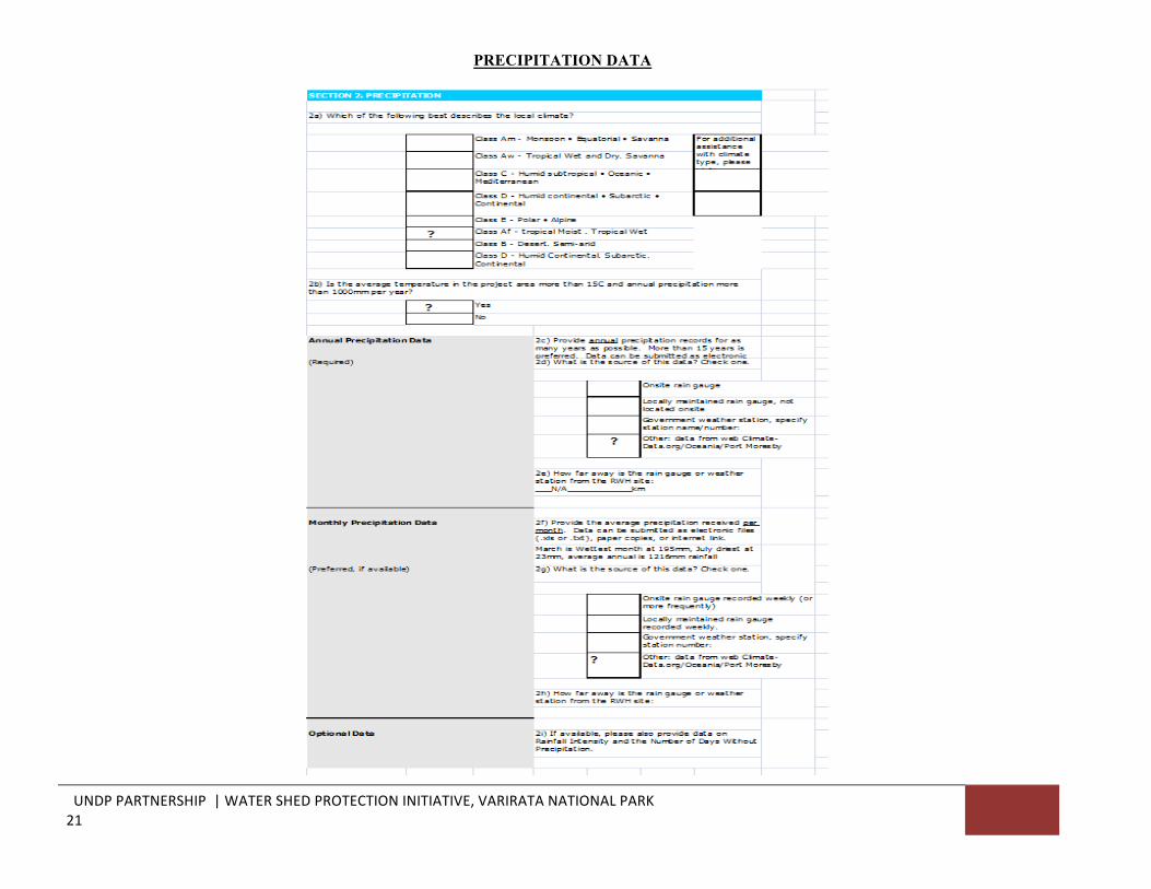
PRECIPITATION DATA
UNDPPARTNERSHIP|WATERSHEDPROTECTIONINITIATIVE,VARIRATANATIONALPARK22
WATER ACCESS INTERVENTION
UNDPPARTNERSHIP|WATERSHEDPROTECTIONINITIATIVE,VARIRATANATIONALPARK23
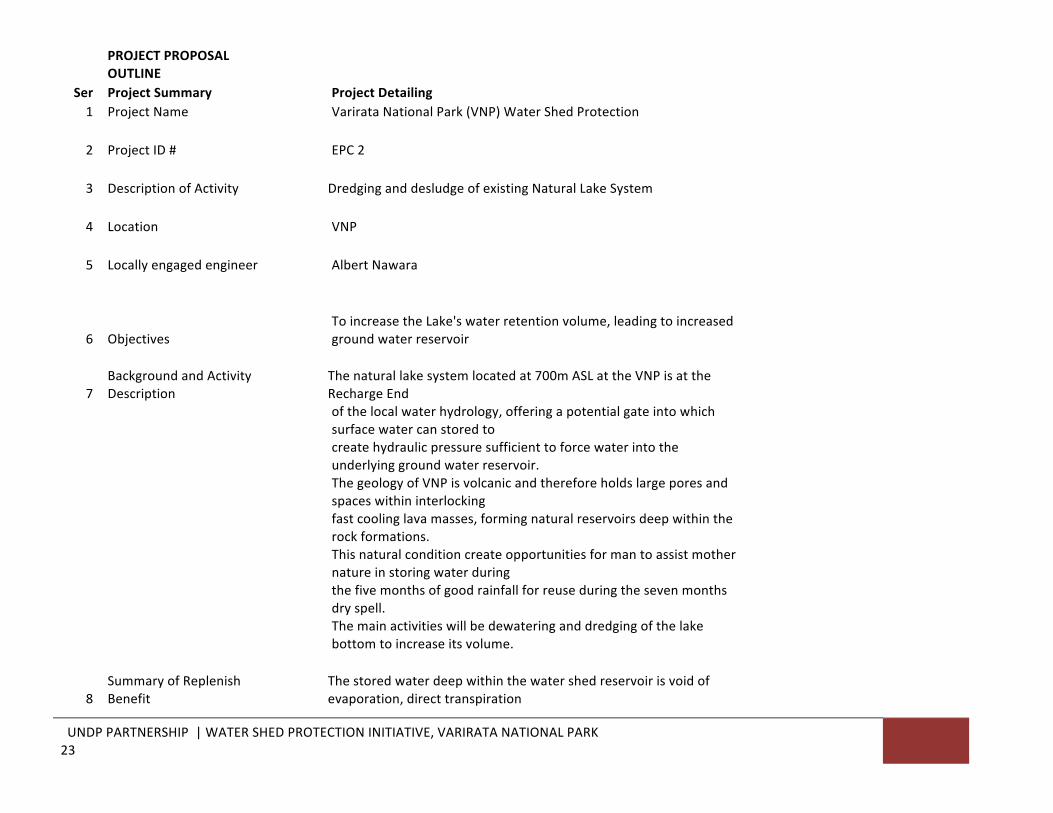
PROJECTPROPOSALOUTLINE
Ser ProjectSummary ProjectDetailing 1 ProjectName VarirataNationalPark(VNP)WaterShedProtection
2 ProjectID# EPC2
3 DescriptionofActivity DredginganddesludgeofexistingNaturalLakeSystem
4 Location VNP
5 Locallyengagedengineer AlbertNawara
6 Objectives ToincreasetheLake'swaterretentionvolume,leadingtoincreasedgroundwaterreservoir
7BackgroundandActivityDescription
Thenaturallakesystemlocatedat700mASLattheVNPisattheRechargeEnd
ofthelocalwaterhydrology,offeringapotentialgateintowhichsurfacewatercanstoredto
createhydraulicpressuresufficienttoforcewaterintotheunderlyinggroundwaterreservoir.
ThegeologyofVNPisvolcanicandthereforeholdslargeporesandspaceswithininterlocking
fastcoolinglavamasses,formingnaturalreservoirsdeepwithintherockformations.
Thisnaturalconditioncreateopportunitiesformantoassistmothernatureinstoringwaterduring
thefivemonthsofgoodrainfallforreuseduringthesevenmonthsdryspell.
Themainactivitieswillbedewateringanddredgingofthelakebottomtoincreaseitsvolume.
8SummaryofReplenishBenefit
Thestoredwaterdeepwithinthewatershedreservoirisvoidofevaporation,directtranspiration
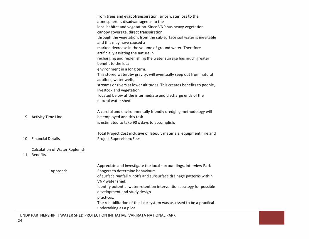
UNDPPARTNERSHIP|WATERSHEDPROTECTIONINITIATIVE,VARIRATANATIONALPARK24
fromtreesandevapotranspiration,sincewaterlosstotheatmosphereisdisadvantageoustothe
localhabitatandvegetation.SinceVNPhasheavyvegetationcanopycoverage,directtranspiration
throughthevegetation,fromthesub-surfacesoilwaterisinevitableandthismayhavecauseda
markeddecreaseinthevolumeofgroundwater.Thereforeartificiallyassistingthenaturein
rechargingandreplenishingthewaterstoragehasmuchgreaterbenefittothelocal
environmentinalongterm.
Thisstoredwater,bygravity,willeventuallyseepoutfromnaturalaquifers,waterwells,
streamsorriversatloweraltitudes.Thiscreatesbenefitstopeople,livestockandvegetation
locatedbelowattheintermediateanddischargeendsofthenaturalwatershed.
9 ActivityTimeLine Acarefulandenvironmentallyfriendlydredgingmethodologywillbeemployedandthistask
isestimatedtotake90xdaystoaccomplish.
10 FinancialDetails TotalProjectCostinclusiveoflabour,materials,equipmenthireandProjectSupervision/Fees
11CalculationofWaterReplenishBenefits
Approach Appreciateandinvestigatethelocalsurroundings,interviewParkRangerstodeterminebehaviours
ofsurfacerainfallrunoffsandsubsurfacedrainagepatternswithinVNPwatershed.
Identifypotentialwaterretentioninterventionstrategyforpossibledevelopmentandstudydesign
practices.
Therehabilitationofthelakesystemwasassessedtobeapracticalundertakingasapilot
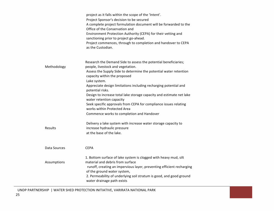
UNDPPARTNERSHIP|WATERSHEDPROTECTIONINITIATIVE,VARIRATANATIONALPARK25
projectasitfallswithinthescopeofthe'Intent'. ProjectSponsor'sdecisiontobesecured
AcompleteprojectformulationdocumentwillbeforwardedtotheOfficeoftheConservationand
EnvironmentProtectionAuthority(CEPA)fortheirvettingandsanctioningpriortoprojectgo-ahead.
Projectcommences,throughtocompletionandhandovertoCEPAastheCustodian.
Methodology ResearchtheDemandSidetoassessthepotentialbeneficiaries;people,livestockandvegetation.
AssesstheSupplySidetodeterminethepotentialwaterretentioncapacitywithintheproposed
Lakesystem.
Appreciatedesignlimitationsincludingrechargingpotentialandpotentialrisks.
Designtoincreasetotallakestoragecapacityandestimatenetlakewaterretentioncapacity
SeekspecificapprovalsfromCEPAforcomplianceissuesrelatingworkswithinProtectedArea
CommenceworkstocompletionandHandover
Results Deliveryalakesystemwithincreasewaterstoragecapacitytoincreasehydraulicpressure
atthebaseofthelake. DataSources CEPA
Assumptions 1.Bottomsurfaceoflakesystemiscloggedwithheavymud,siltmaterialanddebrisfromsurface
runoff,creatinganimperviouslayer,preventingefficientrechargingofthegroundwatersystem,
2.Permeabilityofunderlyingsoilstratumisgood,andgoodgroundwaterdrainagepathexists
UNDPPARTNERSHIP|WATERSHEDPROTECTIONINITIATIVE,VARIRATANATIONALPARK26
beneaththenaturallakesystem,
3.Directlakeevaporationandevapotranspirationwillcontinuenaturallyoccurbefore,during
andafterthelakerehabilitationworks,
12 Non-quantifiedbenefits RehabilitationworkswillincreaseVNPVisitorcounttothelakescenery
13 Referencesifany CEPA