Embed Size (px)
Citation preview

�������� ����� �� ��� �������������� �
����� ����� ��� ���� ����������� � � ��������� �����������
� ���� ����� �� � ������� ��� ����
������� ������ !�"�����✆# $%&����' ��� (� (�)�# $%&����' ��� (� &�*�#++!!!�!�����
��� ���� ���������� ����

WMO-No. 933
WORLD METEOR OLOGICAL
ORGANIZATION
Geneva, Switzerland 2001
Weather, Climate and Food Security

Cover: The Valley of Garm in the Alay mountain range in Tajikistan illustrates the range ofclimates over a short distance and the implications for food production in the valley.(Photo: FAO/A. Proto)
WMO–No. 933© 2001, World Meteorological Organization
ISBN 92-63-10933-8
NOTE
The designations employed and the presentation of material in thispublication do not imply the expression of any opinion whatsoever onthe part of the Secretariat of the World Meteorological Organizationconcerning the legal status of any country, territory, city or area, or ofits authorities, or concerning the delimitation of its frontiers orboundaries.

FOREWORD
It is estimated that by 2020, the world’s popu-lation will reach 7.5 billion and that much ofthis growth will occur in the developing world.To meet the increasing global demand forcereals, for example, the world's farmers willhave to produce 40 per cent more grain in2020. Although the global production ofcereals and global cereal yields rose over the1986–1998 period, the average per capitacereal production for the world remained stag-nant over the period and actually fell in Africaand the Middle East. These disturbing trends insome parts of the world have many negativeimplications for food security and poverty alle-viation, especially when viewed in conjunctionwith the increasing frequency of extremeweather events.
Over the 1996–2000 period, there was analarming increase in the number of countriesaffected by natural disasters, which rose from 28 to 46, mostly in the developing world, wheredisasters have exacerbated the problems of foodsecurity, poverty and land degradation. Forexample, in recent years major storms and floodshave struck Bangladesh, Cambodia, theCaribbean, Central America, China, India,Southern Africa, Venezuela and Viet Nam. Thedirect and indirect costs of the floods inMozambique caused by tropical storms Elyneand Gloria in February and March 2000 are esti-mated at US$ 1 billion, as compared with thecountry's export earnings of US$ 300 million in1999. Severe droughts during 1999–2001affected much of Western Asia, Central Asia andthe Middle East, which resulted in large croplosses.
It has been demonstrated that judiciousapplication of meteorological — including clima-tological and hydrological — knowledge and
information, and seasonal and long-range fore-casts, can considerably assist the agriculturalcommunity in developing and operating sustain-able agricultural systems and increasingproduction in an environmentally sustainablemanner. However, the developing countries aremost vulnerable and least able to adopt improvedtechniques and technologies to counteract theadverse effects of varying environmental condi-tions and climate fluctuations that are among themain factors that prevent the regular supply andavailability of food.
For these reasons, the World MeteorologicalOrganization (WMO) coordinates and providessupport to the National Meteorological andHydrological Services (NMHSs) of its Membercountries in their respective missions ofobserving and understanding weather andclimate, and providing meteorological andrelated services in support of their nationalsocio-economic development plans. TheNMHSs, as part of the global network underthe aegis of WMO, provide scientifically-basedforecasting and warning services that enableall nations to forewarn and protect theirnational communities from the threat of tropi-cal cyclones, severe storms, floods, droughts,forest fires, and other weather-induced naturaldisasters, and that enhance the efficiency andproductivity of the agriculture and forestrysectors.
In the area of food security, the scientificprogrammes and activities of WMO, includingits Agricultural Meteorology Programme,Climate Information and Prediction Services(CLIPS) project and Hydrology and WaterResources Programme, are addressing anumber of important issues related to weather,climate and water in collaboration with other

United Nations organizations, such as the Foodand Agriculture Organization of the UnitedNations (FAO) and the United NationsEducational, Scientific and Cultural Organization(UNESCO), and other relevant regional andinternational organizations. This booklet,which is dedicated to the “World Food Summit— 5 years later”, illustrates WMO’s role incontributing to the achievement of food secu-rity for all nations. We hope that it will also help to provide a better understanding of the
activities and commitment of the meteorologi-cal and hydrological communities to supportthe implementation of the World Food SummitPlan of Action.
4
CLIMATE ISSUES IN THE WORLD FOOD SUMMIT PLAN OF ACTION
The World Food Summit elaborated seven Commitments, of which Commitment 3 — sustainablepolicies and practices essential to adequate and reliable food supplies and to combat pests, droughtand desertification — and Commitment 5 — prevent and prepare for natural disasters and man-madeemergencies and to meet transitory and emergency food requirements — are very relevant for theclimate community from a sustainable development perspective.
Commitment 3 makes repeated reference to climate and climate change (including the United NationsFramework Convention on Climate Change (UNFCCC)) and the related problems of desertification, theloss of biodiversity, the depletion of the ozone layer, which are all related, at least indirectly, to theunsustainable use of climate resources. This Commitment stresses the need to promote the researchneeded to continue international efforts to develop, disseminate and apply climate forecast informationthat will increase sustainable agricultural, fisheries and forestry productivity and be of particularbenefit to developing countries.
Commitment 5 emphasizes the need to maintain, promote and establish the preparedness strategiesand mechanisms, including development and application of climate forecast information forsurveillance and early warning, drought, flood, other natural disasters, pest and disease alertness. Italso underlines the need to support international efforts to develop and apply climate-forecastinformation to improve the effectiveness and efficiency of emergency preparedness and responseactivities, with special efforts to create synergy and avoid duplication.
(G.O.P. Obasi)Secretary-General

Food production in the developing worlddeclined from an average annual growth of 4.2per cent during the period 1991–1995 to 3.5per cent during the period 1996–2000. One ofthe reasons for this decrease was the alarmingincrease in the number of countries affected bynatural disasters, which rose from 28 in 1996to 46 in 2000. In recent years, major stormsand floods have struck Bangladesh,Cambodia, the Caribbean, Central America,China, India, Southern Africa, Venezuela andViet Nam. As of April 2001, some 60 millionpeople in 36 countries were confronting foodshortages of varying degrees.
Climate variability witnessed in recentyears is not new. It has been, and continues tobe, the principal source of fluctuation in globalfood production, particularly in the semi-aridtropical countries of the developing world. Inconjunction with other physical, social andpolitical-economic factors, climate variabilitycontributes to vulnerability to economic loss,hunger, famine and dislocation. In the devel-oping countries, where adoption of improvedtechnologies is too slow to counteract theadverse effects of varying environmentalconditions, climate fluctuations are the mainfactors that prevent the regular supply andavailability of food, the key to food security.Hence it is imperative that weather and climatevariability aspects are well understood so as toformulate more sustainable policies and strate-gies to promote food production and foodsecurity.
From the perspective of world food secu-rity, discussions on climate mostly refer toclimatic hazards and their impacts on worldfood production. However, it is important torecognize that food security involves climate,not only as a natural hazard but also as anatural resource. Climate is a renewableresource, but is variable in time and space. Forproper and efficient use of the other twonatural resources (soil and plant/animalgenetic material) for sustainable agriculture,knowledge of the role of climate is an essentialprecondition. In fact, climate should beregarded as the driving variable for exploita-tion of plant, animal and soil resources. Manyof the ecological implications of agriculturaldevelopment require an improved understand-ing of the interactions between the physical,biological and climatic components.
5
Efficient use of naturalresources is crucial forthe success of rainfed
cropping systems suchas pearl millet/cowpeaintercropping systems
in West Africa(WMO/M.V.K. Sivakumar)
INTRODUCTION

6
Great natural disastersfar exceeding 100 deathsand/or US$ 100 millionin claims, 1950–2000 (Münchener Rück/Munich Re)
Globally, over 70 per cent of natural disastersare related to weather and climate, but in somecountries or regions, these account for thetotality of such disasters. The major naturaldisasters include hurricanes/tropical cyclones/typhoons, floods, droughts, extratropicalstorms, tsunamis and storm surges, tornadoes,sand and dust storms, extreme temperatures,weather-related fires, and pests and diseasesof crops and livestock. The disasters causemany deaths and economic losses amountingto billions of dollars each year. In the past 20years, natural disasters have killed over threemillion people, inflicted injuries, devastatedarable lands, facilitated the spread of diseasesand displaced over one billion people. Annualeconomic costs related to natural disastershave been estimated at about US$ 50–100billion. Indeed, in some years, the globaleconomic losses are much higher, sometimesreaching US$ 440 billion. Furthermore, it isestimated that about 250 000 lives are lostworldwide every year directly or indirectly as aresult of natural disasters.
Climate factors are inexorably linked tobasics of life, including availability of food, safedrinking water and good health. Destruction offood reserves, damage to or loss of watersupplies through drought, or through pollutionof traditional water sources during floods, andincreased incidence of viral and other infec-tious diseases, are some of the impacts thatcan accompany extreme meteorological andhydrological events.
In recent decades, people throughout theworld have become increasingly alarmed bynatural disasters, which are becoming morefrequent and more destructive. Human beings
have not so far been able to control the forcesof nature. They cannot prevent the formationof a tropical cyclone, nor can they preventdroughts, floods, earthquakes or the eruptionof volcanoes. However, they are able tocontain rivers, to stem tides and to build struc-tures that will give considerable, if not total,resistance to the forces of nature. Since naturalphenomena will continue to occur, the prob-lems these present must be faced, giving duepriority to policies for disaster planning,preparedness and prevention.
Tropical cyclones
Tropical cyclones, also known as hurricanes,typhoons or cyclones, afflict most countries inthe tropical and subtropical zones, often withdevastating effect. Indeed, they are among themost devastating of all natural hazards. Their
EXTREME METEOROLOGICAL AND HYDROLOGICAL EVENTS
16
14
12
10
8
6
4
2
01950 1955 1960 1965 1970 1975 1980 1985 1990 1995
Others
Flood
Storm
Earthquake
Num
ber

potential for wrecking havoc caused by theirviolent winds, torrential rainfalls and associ-ated storm surges, high seas in coastal areas,floods, tornadoes and mud slides is aggravatedby their severity, size, frequency of occurrenceand the vulnerability of the extensive areasthey affect.
Tropical cyclones have severe negativeimpacts on agriculture and food security, waterresources, and on other key social andeconomic sectors. For example, it has beenestimated that, globally, tropical cyclonesalone account for an annual average of about20 000 deaths and about US$ 6 million indamages. In 1992, hurricane Andrew, the mostdestructive tropical cyclone, caused losses inthe United States of America estimated at someUS$ 16 billion. Other tropical cyclones, whichwere very intense or which caused orcontributed to major disasters, included the1997 typhoon Winnie in China that affectedover 400 000 hectares (ha) of crop lands,amongst other things, and hurricane Mitch in1998 that devastated Nicaragua, Honduras andGuatemala and displaced about two millionpeople.
El Niño and La Niña
El Niño and La Niña are the most significantexamples of climate variations that haveglobal economic and social implications. ElNiño is a naturally occurring climate phenom-enon, observed every two to seven years andlasting from between three and six seasons,marked by extensive warming of the surfacewaters in the central and eastern tropicalPacific Ocean. The negative or cooling phaseof El Niño that makes the eastern pacificwaters cooler than normal is called La Niña.
El Niño is generally associated with world-wide anomalies in the patterns of precipitationand temperature, as well as with patterns oftropical storms and hurricane activity, thebehaviour of the subtropical jet streams, andmany other general circulation features overvarious parts of the world. It has been foundthat the El Niño events produce consistentclimate patterns. A strong El Niño event islinked to droughts in southeastern Africa,northern Australia, northern Brazil, Indonesiaand the Philippines. Wetter than normal condi-tions tend to occur in tropical east Africa,along the coast of tropical South America andthe subtropical parts of North America (Gulf
7
Far right: HurricaneMitch caused severe
crop lodging atCholuteca, Honduras
(Paul Jeffrey/CCD)
Flooding and soil erosion caused by El
Niño affect sustainableagriculture and food
security in some developing countries
(ISDR)

Coast) and South America (southern Braziland central Argentina).
The 1997/98 El Niño event has beenconsidered as perhaps the strongest of thetwentieth century. This El Niño and the1998/99 La Niña events imposed considerablesocio-economic stress and set back develop-ment in many parts of the globe. The notableglobal impacts included the severe droughtsand forest fires in Indonesia and northeastBrazil, and catastrophic floods in tropical eastAfrica. In Latin America and the Caribbean, tovarious extents, loss of life, destruction ofproperty, damage to food production, foodreserves and transport systems, as well asincreased health risk, were among the manysocio-economic consequences as a result ofHurricane Mitch during the La Niña event. Themajor burden of the natural disasters was inthe developing world. Estimates of globaldamage from the 1997/98 El Niño range fromabout US$ 14 billion from mainly propertydamage to more than US$ 33 billion whenother socio-economic losses are assessed.
Droughts
Drought is a natural hazard originating from adeficiency of precipitation that results in awater shortage for some activities or somegroups. It is the consequence of a reduction inthe amount of precipitation over an extendedperiod of time, usually a season or more inlength, often associated with other climaticfactors — such as high temperatures, highwinds and low relative humidity — that canaggravate the severity of the event. Becausedrought affects so many economic and socialsectors, scores of definitions have been devel-oped by a variety of disciplines; these can begrouped mainly as meteorological, hydrologi-cal, agricultural and socio-economic droughts.
The widespread misery caused by therecurrent droughts in the 1970s and 1980s inthe Sahel and in eastern and southern parts ofAfrica are well known. In 2001, much ofWestern Asia, Central Asia and the Middle Eastsuffered the third year of a continuing droughtthat severely reduced crop yields in manycountries. It was estimated that between June2000 and June 2001, half of Afghanistan’spopulation of about 12 million was affected bydrought, three to four million people severely.The extremely low level of precipitationdestroyed almost all the rain-fed crops anddecimated the livestock. The cereal deficitexceeded 2.3 million tons, more than doublethat of the previous year. In the IslamicRepublic of Iran, a severe drought in 1999 wasfollowed by an extreme drought in 2000 andyet another in 2001. These droughts threat-ened more than 6.4 million acres of irrigatedfarms, 9.88 million acres of rain-fed fields
8
Severe droughts in thefragile ecosystems of thearid and semi-aridregions pose problemsfor vegetation and live-stock management(FAO/R. Faidutti)
and 2.7 million acres of orchards. Agriculturaldamage across the country is estimated atmore than US$ 2.6 billion.
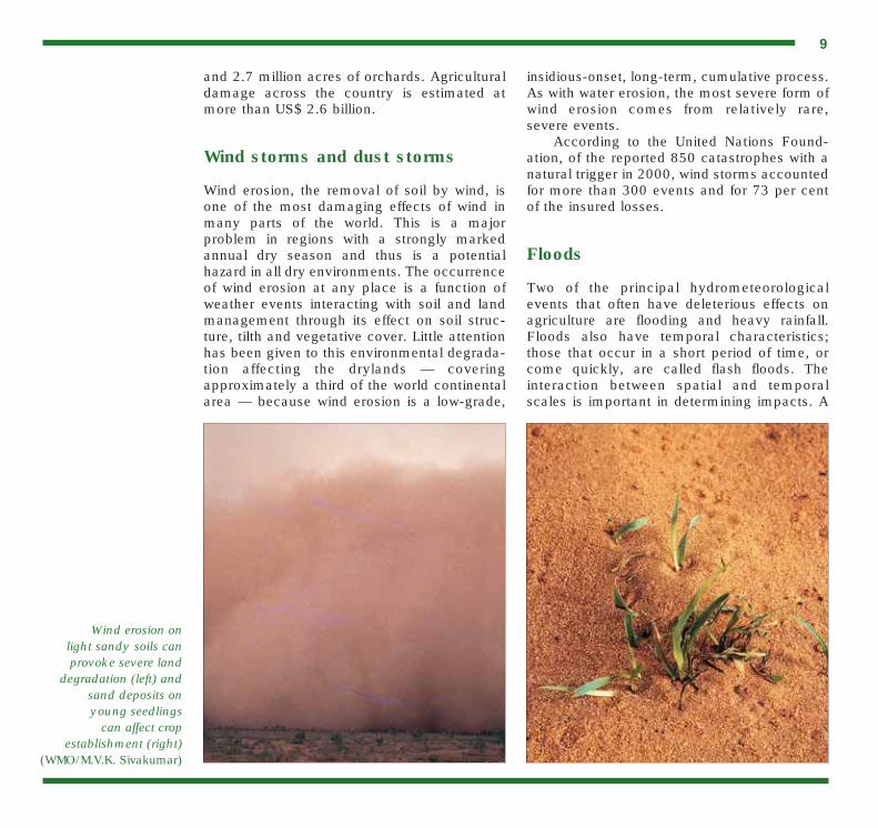
Wind storms and dust storms
Wind erosion, the removal of soil by wind, isone of the most damaging effects of wind inmany parts of the world. This is a majorproblem in regions with a strongly markedannual dry season and thus is a potentialhazard in all dry environments. The occurrenceof wind erosion at any place is a function ofweather events interacting with soil and landmanagement through its effect on soil struc-ture, tilth and vegetative cover. Little attentionhas been given to this environmental degrada-tion affecting the drylands — coveringapproximately a third of the world continentalarea — because wind erosion is a low-grade,
insidious-onset, long-term, cumulative process.As with water erosion, the most severe form ofwind erosion comes from relatively rare,severe events.
According to the United Nations Found-ation, of the reported 850 catastrophes with anatural trigger in 2000, wind storms accountedfor more than 300 events and for 73 per centof the insured losses.
Floods
Two of the principal hydrometeorologicalevents that often have deleterious effects onagriculture are flooding and heavy rainfall.Floods also have temporal characteristics;those that occur in a short period of time, orcome quickly, are called flash floods. Theinteraction between spatial and temporalscales is important in determining impacts. A
9
Wind erosion on light sandy soils canprovoke severe land
degradation (left) and sand deposits on young seedlings
can affect crop establishment (right)
(WMO/M.V.K. Sivakumar)

very intense (extreme) rainfall can result incatastrophic flood damage even though itoccurred for a relatively short period of time,and/or at the proper location, at the propertime of year, etc. Flash floods and landslides in Venezuela in December 1999 caused 30thousand deaths. The direct and indirect costsof the floods in Mozambique caused by tropicalstorms Elyne and Gloria in February andMarch 2000 are estimated at US$ 1 billion, ascompared with the country’s export earningsof US$ 300 million in 1999.
The effects of floods on agriculture can beclassified as direct or indirect. Direct effectsare those that regard the property and incomeof individuals, enterprises and the publicsector. Indirect effects are slower and oftenmore widespread (geographically, economi-cally, etc.) than direct effects, and are theresult of decreased income, environmentaldegradation and other factors. In general,
direct effects are much easier to quantify,while estimates of indirect effects are oftenincomplete due to their complicated impactsthroughout society.
10
In the Sahel, flash floodson sandy soils can causeland degradation andaffect crop productivity(WMO/M.V.K. Sivakumar)
Few countries or communities are immunefrom extreme weather events and climateextremes. Some communities are morevulnerable to particular events and suffer morefrequently than others. Notwithstanding theclimatological risk that is related to geography,the extent to which an extreme meteorologicalevent becomes a natural disaster has much todo with planning, early warning, protectivemeasures taken and the resilience of a
community, including its ability to recoverafter an extreme weather event.
WMO is the United Nations specializedagency responsible for meteorology and oper-ational hydrology. WMO provides support tothe National Meteorological and HydrologicalServices (NMHSs) of its 185 Member Statesand Territories in their respective missions ofobserving and understanding weather andclimate and providing meteorological andrelated services in support of national needs.These needs especially relate to protection oflife and property, safeguarding the environ-ment and contributing to sustainabledevelopment.
The scientific programmes of WMO havebeen vital in expanding knowledge of theclimate system. The systematic observationscarried out using standardized methods haveprovided worldwide data for analysis, researchand modelling of the atmosphere and itschanging patterns of weather systems.Specialized programmes of observations,including those for chemical constituents ofthe atmosphere and characteristics of theoceans and their circulations, have led to abetter understanding of interactions betweenthe domains of the climate system (the atmos-phere, the oceans, the land surface and thecryosphere) and of climate variability andchange.
Early warning systems
The enhanced application of science and tech-nology, including prediction and early warningwith good lead-time about impending weatherand climate hazards, provides the best solution
11
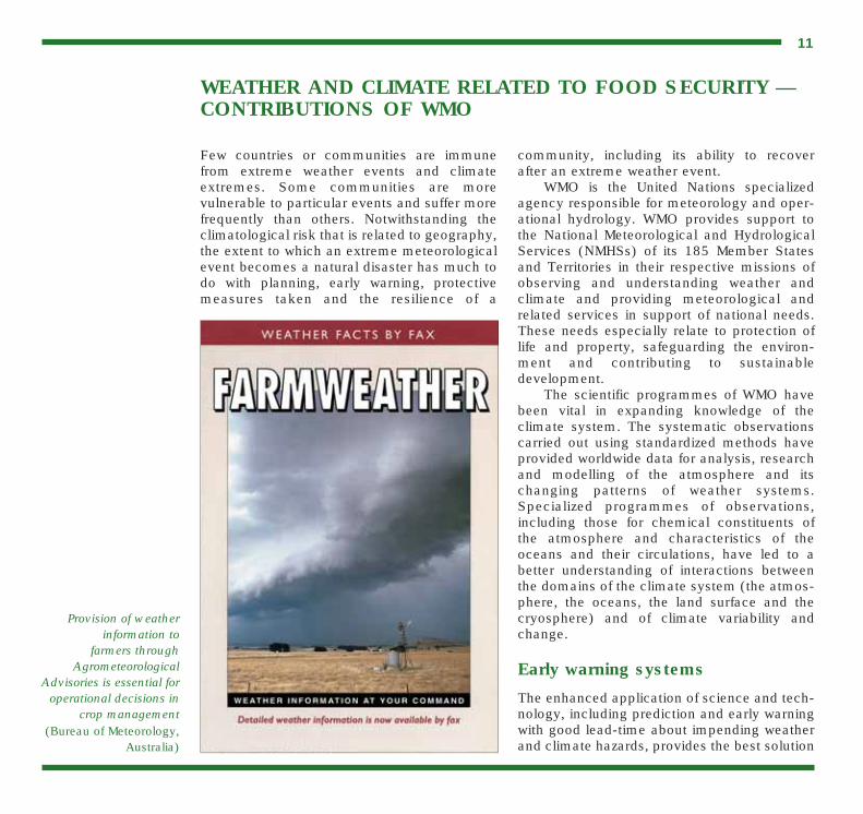
Provision of weatherinformation to
farmers throughAgrometeorological
Advisories is essential foroperational decisions in
crop management(Bureau of Meteorology,
Australia)
WEATHER AND CLIMATE RELATED TO FOOD SECURITY —CONTRIBUTIONS OF WMO

12
Prediction on seasonal and longer time scales, as a basis forwarning, is a developing community service. WMO believesthat the progress being made in climate research, whereappropriate, should be translated into forms that will elevatethe socio-economic well-being of humanity. In 1995, theWMO Twelfth World Meteorological Congress endorsed theClimate Information and Prediction Services (CLIPS) projectto build on research achievements and provide information,including expectations of future conditions, to improveeconomic and social decisions. This has come at a timewhen there is a growing public awareness of possiblehuman-influenced changes in climate, and the impact onsociety of variations in climate, such as those caused by ElNiño. An important feature of CLIPS is analysis of the pastand contemporary climate and integration with near-futureclimate predictions.
One of the immediate tasks of the CLIPS project has beento assist in developing the capability of NMHSs to receiveand utilize the global climate information and predictionproducts which are currently being produced by severalmajor climate centres around the world. Climate informationand prediction services are frequently aimed at alleviating ormitigating negative impacts of extreme climate conditions oranomalies, and also at taking advantage of any positiveimpacts. For a number of years, El Niño predictions havebeen used by several countries to provide early warningsand in disaster preparedness. WMO has been coordinatingthe activities of various interested groups through the co-sponsorship of workshops, seminars and conferences, andthe organization of special training events on El Niño.
In collaboration with partner institutions, WMO has orga-nized several Regional Climate Outlook Fora (RCOF) inmany parts of the world. The fora have enabled researchersfrom various advanced climate prediction centres, regionaloperational climate centres and experts from NMHSs todevelop consensus or consolidated climate outlook guid-ance products, together with guidance on interpretation, fordissemination to users. The RCOF proved to be a very effec-tive capacity-building mechanism for the NMHSs in terms of
the transfer of knowledge of the current state of develop-ment and limitations of seasonal climate prediction science.The fora were therefore used to enhance the regional andclimate outlooks and associated impact projections duringEl Niño events.
Some examples to illustrate the use of El Niño predictionsto provide early warning include:• Peru, where the El Niño information has been used for
sustainable agricultural production through the alterna-tion of crops, for example rice and cotton, during dryyears;
• In Brazil, enhanced agricultural production is reflectedwhen El Niño information was used in making specificagricultural decisions when the El Niño events took placein the last two decades;
• Too much or too little rainfall, which is common in someregions during warm and cold El Niño phases, has beenassociated with various vector-borne and food-relateddiseases. In Colombia, linkages between El Niño andmalaria cases were established.An important component of the CLIPS project is in the
area of training and technology transfer. The objective is to
Climate Prediction Services (CLIPS)
Cost/loss table for an adverse weather event
IS THE EVENT FORECAST?
YES NO
HITFinancial losses occur
but are mitigatedthrough taking
appropriate protective action
FALSE ALARMCosts of protection areborne, but protection is
not required
CORRECT REJECTIONNo losses; no costs;
outcome is that expectedfrom normal activities
without the event
MISSFull losses occur,
as no protective action is takenYES
NO
DID
TH
EEV
ENT
OC
CU
R?
(After Foresight, Department of Trade and Industry, UK)

to minimize loss of life and property damagescaused by natural disasters. Prediction andearly warning information and products arevital in enhancing food and agriculturalproduction as well as in the utilization andmanagement of fresh water, energy and othernatural resources that are sensitive to extremeweather and climate events.
In order to improve on the lead-time ofprediction and early detection of extrememeteorological and hydrological events, and ofclimate variability and change, proper under-standing of the processes that control globalweather and climate systems is required.These processes include weather predictionresearch at all time scales and modellingcapacity, especially the potential to improvethe prediction of climate variability or changeat local or regional levels. WMO provides aninternational framework for collaboration in allmeteorological and hydrological researchareas that are of national, regional and globalinterest.
Over the last several decades, majoradvances have been made in weather fore-casting, that is, up to about a week formid-latitudes, but the understanding of El Niñorepresents the first major breakthrough in theprediction of the longer-term climate. Over thelast decade, a new era has emerged for climateprediction. A new generation of coupledclimate models, which can be nested withhigh-resolution regional models, is now avail-able. Some of these coupled models can nowbe used to provide climate outlooks at multi-seasonal to interannual time scales. Forexample, it is now possible to predict El Niño-related sea-surface temperature anomalies, ina time-span ranging from seasons to over oneyear in advance. Recent researches have alsoshown consistent worldwide anomalies in theoccurrence of floods, hurricanes, severe stormactivities, and many other extreme climate
13
ensure that NMHSs have access to the regionaland global climate monitoring products thatare routinely generated in support of the WorldClimate Programme (WCP) and that the staffof NMHSs have the necessary training toprovide services in support of community deci-sion-making. The CLIPS project is closelylinked to the WMO Agricultural MeteorologyProgramme and the Hydrology and WaterResources Programme to build on existinglinkages with community managers in the landand water resource areas.
The Drought WatchService of the Bureau of
Meteorology ofAustralia providesinformation on theseverity of El Niño
conditions(Bureau of Meteorology,
Australia)
Perth
Adelaide Sydney
Brisbane
Melbourne
Canberra
Hobart
Darwin
SeriousSevereExtreme
14
The purpose of the Agricultural Meteorology Programme ofWMO is to support food and agricultural production andactivities. The main long-term objectives are:• To promote economically viable and high-quality produc-
tion so that it can be sustainable and environment-friendlyby strengthening Members’ indigenous capabilities toprovide relevant meteorological services to agriculturaland other related sectors;
• To foster a better understanding by farmers and otherend-users in the agricultural, forestry and related sectorsof the value and use of meteorological (including climato-logical) information in planning and operational activities.The following projects are being implemented by the
Agricultural Meteorology Programme during the period2000–2003.
Agrometeorological Applications
To promote further development and application of basicknowledge on relationships between meteorological factorsand agricultural production including its quality and protec-tion of the agricultural resource base and the output forsustainable management of farming systems, forestry andlivestock in line with the World Food Summit Plan of Action.
Use of Climate Forecasts in Operational Agriculture
To promote more active use of seasonal to interannualclimate forecasts and current weather advisories in agricul-tural planning and operations in active collaboration with theCLIPS project.
Agrometeorological Data Management
To provide Members with techniques and methods toobserve, register, collect, manage, store and exploit ground-based, radar and remotely-sensed meteorological, climato-logical and agronomic data in the most timely and person-nel-efficient manner.
Communication of Agrometeorological Information
To develop methods, procedures and techniques for thedissemination of agrometeorological information with the fullinvolvement of users.
Agrometeorology for Extreme Events
To focus on studies and applications of agrometeorologicalinformation needed to cope better with droughts and deser-tification, flooding, tropical cyclones, storm surges, locustinvasions, and other spreading and intensifying environmen-tal hazards.
Agrometeorological Adaptation Strategies to Climate Variability and Climate Change
To develop agrometeorological adaptation strategies toclimate variability and climate change especially in thevulnerable regions where food and fibre production is mostsensitive and vulnerable to climatic fluctuations.
Agricultural Meteorology Programme of WMO

anomalies associated with El Niño. Earlywarning of any impending El Niño phenome-non, one or several seasons in advance, is nowbeing used in disaster preparedness in thoseparts of the world where El Niño signals arestrong.
The use of predictions of El Niño a year ormore in advance, such as the early warning ofunusual rainfall and drought patterns, thereforehas significant economic benefits in variousregions. Socio-economic losses cannot beentirely eliminated, but timely and appropriatemitigation measures can certainly reduce theimpacts. In fact, early information on El Niñoepisodes allows for advanced national plan-ning, with considerable advantages in manysectors of the economy such as agriculturalproduction, water resources management andfisheries. In the case of the 1997/98 El Niñoevent, advances in El Niño-related science andin monitoring the sea-surface temperatures in
the Pacific Ocean enabled scientists in theNMHSs to predict its formation longer inadvance than all the previous events. Withrecent developments in communication tech-nology, including the use of Internet,information on El Niño was rapidly and timelydisseminated throughout the world. Thesedevelopments enabled many governments totake appropriate measures, and stimulatedinternational cooperation and integrated effortsto address the associated impacts.
About 80 tropical cyclones form annuallyover tropical oceans. They have a lifetimevarying from days to a week or two, some-times longer. A particular important aspect oftropical cyclones, which is distinct from someof the other natural hazards, is the worldwideavailability of early warning systems as a basisfor preparedness action and, hence, disastermitigation. As a result of international cooper-ation and coordination, and with the aid ofmeteorology and modern technology, such assatellites, weather radars and computers, alltropical cyclones around the globe are nowbeing monitored from their stages of formationthroughout their lifetime by designatedRegional Specialized Meteorological Centres(RSMCs) located in Miami, Nadi (Fiji), NewDelhi, Tokyo and La Réunion, as well as byother centres of NMHSs. These centres provideforecasts on the behaviour of tropicalcyclones, their movement and changes inintensity, and on associated phenomena,mainly storm surges and floods. They issuetimely warnings to all those who are threat-ened. The activities of the centres arecoordinated at the global and regional levelsby WMO through its World Weather Watch(WWW) and Tropical Cyclone Programmes.
A good example of how an appropriatesatellite-based early warning system can helpcountries reduce human and economic lossesis that of Bangladesh. After the killer cyclones
15
Making users aware ofthe value of weather
information promotesimproved applications of
weather and climaticinformation at the
field level(WMO/M.V.K. Sivakumar)
of 1971 (300 000 deaths, 1.3 million home-less) and 1991 (138 000 deaths), the govern-ment put in place an early warning system.When another devastating cyclone of equiva-lent intensity struck in 1994, the ultimateimpact was many times less — 250 deaths,0.5 million homeless — compared to thedisastrous 1971 and 1991 events.
Reducing vulnerability
Due to globalization, population pressures andurbanization, many farmers, particularly indeveloping countries, are being forced out oftheir traditional cropping systems and intoadopting systems and crops expected to bemore productive and more relevant to market-related economies. Also, cropping and herdgrazing have expanded into marginal lands tofurther increase overall output. The economicvulnerability of many traditional and subsis-tence farmers has therefore increasedmarkedly due to the introduction of unfamiliarcrops and farming techniques, their new expo-sure to market forces, the use of marginallyproductive lands and the impacts of global andlocal climate variability.
There have been unintended consequencesto new land-use patterns in some regions that will reduce the long-term sustainability of thesystem. Water logging and increased salinity areproblems associated with both clearing of forestsfor dryland farming and the introduction of irrigated farming. Expansion or intensification of dryland cropping and herd grazing canincrease susceptibility of soils to wind erosion.
A range of agrometeorological services isavailable to assist in evaluation of new crop-ping strategies and the sustainability of newcropping regimes within the context of thelocal climate. WMO, through its AgriculturalMeteorology Programme, works with the Food
and Agriculture Organization of the UnitedNations (FAO) to address regional land-useproblems and in assisting NMHSs in introduc-ing services that support sustainable land-usepractices.
Understanding climatechange and impacts
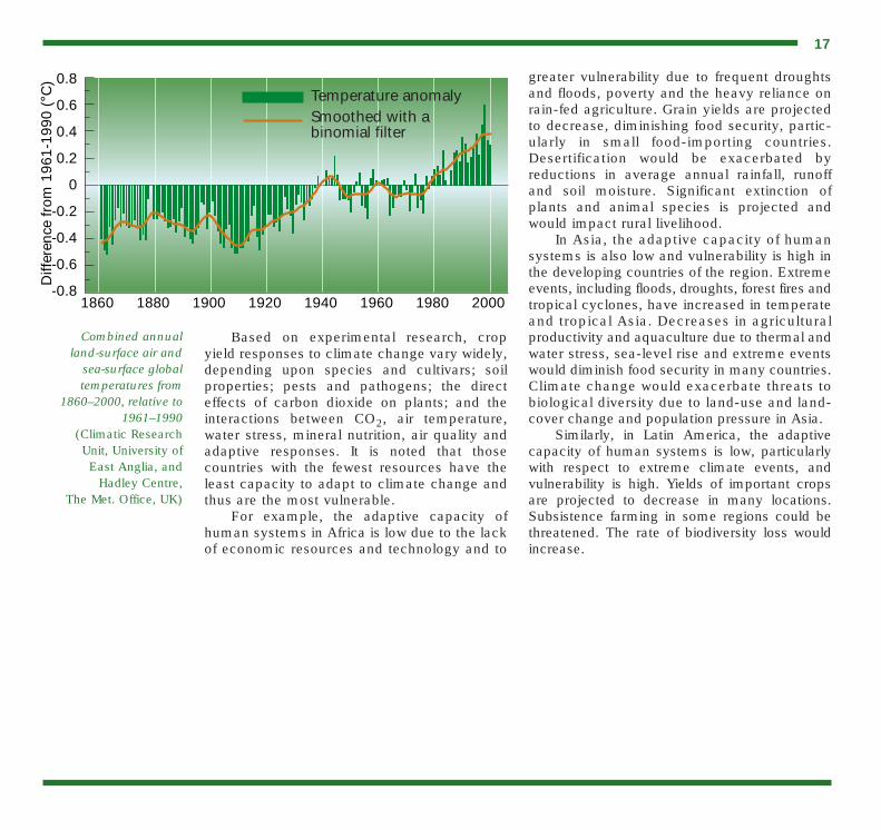
Concern about climate has touched communi-ties in all parts of the globe. As communitieshave adapted to their local climate, they aresensitive to its variations, and many are threat-ened by climate change. The WMO/UnitedNations Environment Programme (UNEP)Intergovernmental Panel on Climate Change(IPCC) assessments have shown that theobserved increases in atmospheric greenhousegases (GHGs) may lead to global warming,sea-level rise and space-time changes in thenormal patterns of hydrometeorological para-meters. Based on evidence from climatemodels together with observations from instru-mental and other available records, the IPCCThird Assessment Report (2001) concludedthat: “There is new and stronger evidence thatmost of the warming observed over the last 50years is attributable to human activities”.Human influences will continue to changeatmospheric composition throughout thetwenty-first century. By 2100, the concentra-tion of CO2 is expected to increase from thepresent figure of 370 ppm to 540–970 ppm.Over the period 1990 to 2100, it is projectedthat the average global air temperature willincrease by 1.4 to 5.8°C and global mean sealevel will rise by somewhere between 9 cm and88 cm. According to that reported in the IPCCassessments, recent regional climate changes,particularly temperature increases, havealready affected many physical and biologicalsystems.
16
Based on experimental research, cropyield responses to climate change vary widely,depending upon species and cultivars; soilproperties; pests and pathogens; the directeffects of carbon dioxide on plants; and theinteractions between CO2, air temperature,water stress, mineral nutrition, air quality andadaptive responses. It is noted that thosecountries with the fewest resources have theleast capacity to adapt to climate change andthus are the most vulnerable.
For example, the adaptive capacity ofhuman systems in Africa is low due to the lackof economic resources and technology and to
greater vulnerability due to frequent droughtsand floods, poverty and the heavy reliance onrain-fed agriculture. Grain yields are projectedto decrease, diminishing food security, partic-ularly in small food-importing countries.Desertification would be exacerbated byreductions in average annual rainfall, runoffand soil moisture. Significant extinction ofplants and animal species is projected andwould impact rural livelihood.
In Asia, the adaptive capacity of humansystems is also low and vulnerability is high inthe developing countries of the region. Extremeevents, including floods, droughts, forest fires andtropical cyclones, have increased in temperateand tropical Asia. Decreases in agriculturalproductivity and aquaculture due to thermal andwater stress, sea-level rise and extreme eventswould diminish food security in many countries.Climate change would exacerbate threats tobiological diversity due to land-use and land-cover change and population pressure in Asia.
Similarly, in Latin America, the adaptivecapacity of human systems is low, particularlywith respect to extreme climate events, andvulnerability is high. Yields of important cropsare projected to decrease in many locations.Subsistence farming in some regions could bethreatened. The rate of biodiversity loss wouldincrease.
17
Combined annual land-surface air and
sea-surface globaltemperatures from
1860–2000, relative to1961–1990
(Climatic Research Unit, University of East Anglia, and
Hadley Centre, The Met. Office, UK)
1860 1880 1900 1920 1940 1960 1980 2000
-0.4
-0.6
-0.8
-0.2
0
0.2
0.4
0.6
0.8
Diff
eren
ce fr
om 1
961-
1990
(°C
)
Temperature anomalySmoothed with abinomial filter

The agricultural community can receive usefulassistance from agrometeorologists in devel-oping strategies to adapt to climate variabilityand climate change, which should be validatedon-farm for improved extension advisories,together with the farmers. The increasedfrequency and magnitude of extreme eventshave been frequently mentioned as potentialcharacteristics of future global climate. Evensmall changes in the frequency of extremeevents have a disproportionate effect. Forinstance, the life cycle of perennial plantschanges drastically if the frequency of extremeevents increases, because seedling establish-ment and the mortality of these plants arehighly sensitive to extremes. Both the stabilityor forage supply and the balance betweentemperature and subtropical species arelargely controlled by the frequency of extremeclimatic events and thus are easily subject tochange in a CO2-warmed climatic changescenario. One important aspect of short-termextreme events is the apparent randomnessand abruptness with which they arrive.
The agricultural sector must react to thedemands of reducing its contributions to poss-ible global warming, which asks for changes inproduction methods, and must be betterprepared to react to the (increasing) variabili-ties and extremes, and prepare scenarios forpossible lasting change. The character of thisneed to adapt is determined initially by wors-ening limiting factors of agricultural productionand the vulnerability of farming systems. Therate of required adaptation to climate variabil-ity and climate change as well as the impacton the disruptions resulting from other socio-economic or environmental changes have to
be taken into account. Easy access to devel-oped and well-tested technology is importantfor many countries, however local innovationsshould not be neglected.
Agroforestry plays an important role as doother afforestation techniques, with an addi-tional role as CO2 sink. There are numerousdrought adaptation measures: these rangefrom time of planting, practising water conser-vation techniques, using crops with veryextensive and deep rooting systems to plantingdrought-resistant varieties. Simple agro-meteorological techniques exist to improvewater use efficiency of crops in drylands, forexample tillage in the fallow period, mulching,soil moisture management with adapted fertil-ization, crop rotation and multiple cropping.
To ensure food security, an effectiveresponse strategy to climate variability andclimate change should pay adequate attentionto the possibilities of linking response optionswith responses to socio-economic transitionphenomena. Some agrometeorological adap-tation strategies include:• Regular weather advisories on farming,
production and cropping systems, inaccordance with the possibilities forchange in the different farming communi-ties. This applies to techniques of usinginputs, soil conditions and planting densi-ties, choices of cropping systems andvarieties, applications of (improved)protection strategies in crop/tree space andapplications of other multiple croppingmicroclimate management and manipula-tion techniques;
• Dissemination of information through on-linecurrent advisories, on time scales and in
18
AGROMETEOROLOGICAL ADAPTATION STRATEGIES TOINCREASING CLIMATE VARIABILITY AND CLIMATE CHANGE
Climate changerefers to astatisticallysignificantvariation in eitherthe mean state ofthe climate or inits variability,persisting for anextended period(typicallydecades orlonger). Climatevariability refersto variations inthe mean stateand otherstatistics (such as standarddeviations, theoccurrence ofextremes, etc.) of the climate onall temporal andspatial scalesbeyond that ofindividualweather events.
(IPCC, 2001)

19
Five-day weather forecast by telefax foragriculture in Switzerland
In 1994, the Swiss Meteorological Institutedeveloped a forecast for a five-day period espe-cially for agricultural establishments, itsupstream and downstream enterprises, as wellas for further outdoor activities. The forecasthas been produced daily since 1 March 1995.Clients can call it in by telefax whenever theywish to do so, against a corresponding charge.The five-day forecast for agriculture contains aforecasting part in the form of a text and‘particularities’, such as recommendations (forexample weather for hay harvest), warnings(for example frost warnings) and climate values(for example information on decades, monthsor seasons). In addition, listed is some agricul-tural work which can be better planned andcarried out because of the forecasts (forexample sowing bed preparation, frost protec-tion measures, irrigation management,optimization of plant protection measures, opti-mization of stock transport facilities, oroptimization of crops (date or period),purchases, sales, quantities and qualities).
Relationship between weather and sheep feeding in China
The efficiency of animal husbandry in the InnerMongolia area of China is very low. The mainproblem is that the winter is so cold that allgrass withers. Animals only grow in the warmerhalf of the year, with their weight decreasing inwinter; some years, weak animals even die inthe spring. Therefore, herders usually makehay in the summer, from 10 July to 20 August,
and feed sheep in winter. But the hay season isalso the rainy season. The weather forecastservice therefore is very important to herders.Agrometeorologists in Inner Mongolia havestudied the relationship between weather andthe hay harvest and have developed an index ofthe best haying time: no rain for more thanthree days, mean daily humidity less than 75per cent, mean air temperature above 20°C andwind velocity above 3 m/s. Under these condi-tions, the water content of hay will decrease tobelow the safe index of 18.5 per cent in two tothree days. Agrometeorologists also deter-mined the quantity of hay (kg) required forsheep feeding according to body weight (kg)and mean daily temperature (°C). This tech-nique has become popular in many counties ofInner Mongolia and herders had an increasedprofit of 14 yuan per sheep.
Examples of Agrometeorological Applications
FAO
/A. O
doul
spatial scales as required. Examples are:weather and climate forecasts; and timelyadvice on farm operations such as sowingdates, weeding, fertilizer application, spray-ing, integrated pest management, harvestingand drying;
• Promoting the more active use of seasonalto interannual climate forecasts and ofcurrent climate bulletins in agriculturalplanning and operations.
Flood management
Flood management is a broad concept thatfocuses on coping with flood hazards throughthe combination of policy, institutional, regula-tory and physical measures such as replantingupstream catchment areas, while recognizingthat floods can never be fully controlled.
WMO’s long-standing activities in theareas of flood risk assessment and flood fore-casting have recently been enhanced by a jointinitiative with the Global Water Partnership,namely the Associated Programme on FloodManagement for which a technical support unitlocated within WMO Headquarters is providingthe global coordination.
The Terrestrial Observation Panel forClimate (TOPC), sponsored by the GlobalClimate Observing System (GCOS) and theGlobal Terrestrial Observing System (GTOS),has recognized the critical need for improvedavailability and access to global hydrological
data, information and products for climate andhydrological research and applications toquantify key environmental change processes,identify significant trends, assess variabilityand develop response strategies.
In a joint effort, WMO and the UnitedNations Educational, Scientific and CulturalOrganization (UNESCO) have restructured the World Climate Programme—Water(WCP–Water) identifying three main areas ofwork, namely: variability and trends in waterresources availability; water climate andhealth; and water, climate and agriculture. Astrong expression of interest is now required byorganizations and agencies to contribute withinthe framework of the Programme.
20
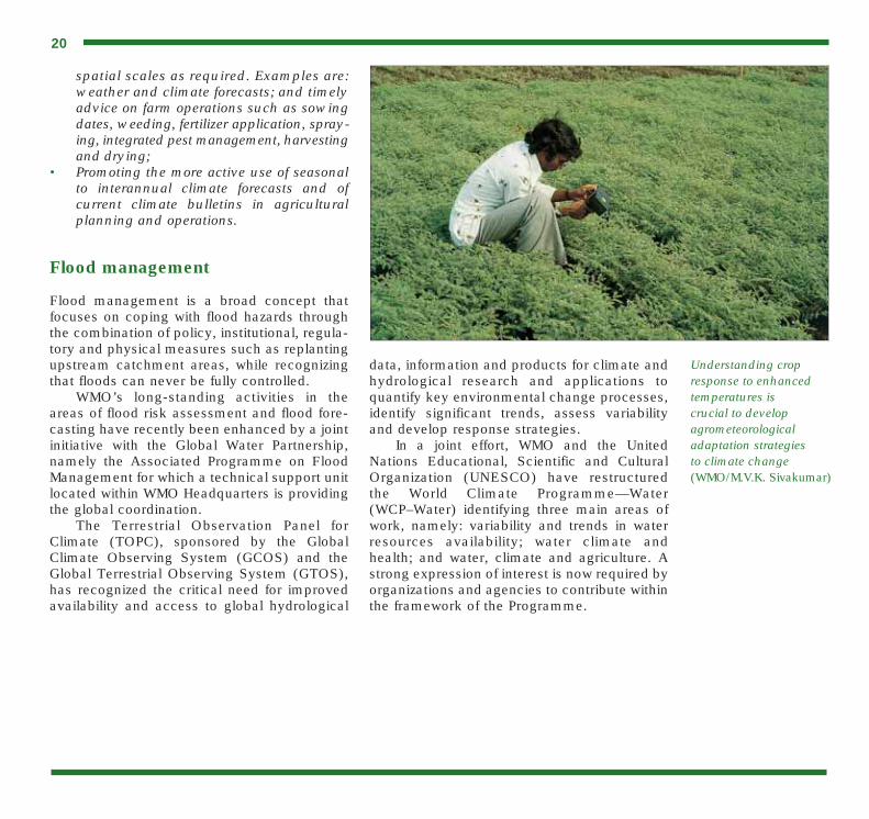
Understanding cropresponse to enhancedtemperatures is crucial to develop agrometeorological adaptation strategies to climate change(WMO/M.V.K. Sivakumar)
21
Everyone agrees that fresh water is a critical resource, butmuch remains to be done to ensure that all the world’s popu-lation has equitable access to sufficient water to meet evenbasic needs. The Comprehensive Assessment of the FreshwaterResources of the World showed that 40 per cent of the world’s population today lives in countries which have medium-to-high water stress, and it is expected that by 2025 two-thirds of the population will do so. Demand for watercan only increase, but growing pollution is likely to reduce the available quantity of suitable water.Irrigated agricultureand hydroelectricpower generationcompete with otheruses for limited waterwithin national bound-aries. At the sametime, maintaining thehealth of aquatic eco-systems is increas-ingly accepted as anessential concern.There are about 300river basins andnumerous aquifers,which are sharedamong two or morenations; competitionfor water among nations could become a potential source ofconflict.
Adequate information is essential for wise managementof water resources. Sadly, at the global scale our ability toprovide information about the status and trend of waterresources is declining. Many developing countries are unableto maintain their systems for acquiring water-related data,
and for disseminating them to decision makers, engineers,resource managers and the public. To counter these trends,an essential goal of WMO is to assist its Members inmaintaining and improving their information systems. TheOrganization uses such means as technology transfer andtraining, collaboration among National Meteorological andHydrological Services, and international exchange of dataand information.
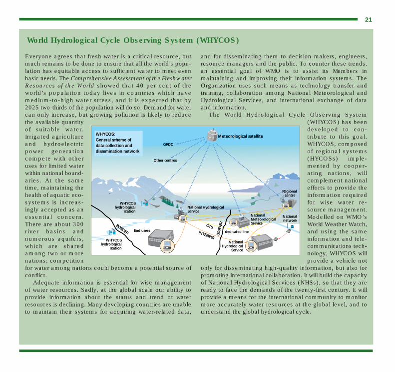
The World Hydrological Cycle Observing System(WHYCOS) has beendeveloped to con-tribute to this goal.WHYCOS, composedof regional systems(HYCOSs) imple-mented by cooper-ating nations, willcomplement nationalefforts to provide theinformation requiredfor wise water re-source management.Modelled on WMO’sWorld Weather Watch,and using the sameinformation and tele-communications tech-nology, WHYCOS willprovide a vehicle not
only for disseminating high-quality information, but also forpromoting international collaboration. It will build the capacityof National Hydrological Services (NHSs), so that they areready to face the demands of the twenty-first century. It willprovide a means for the international community to monitormore accurately water resources at the global level, and tounderstand the global hydrological cycle.
World Hydrological Cycle Observing System (WHYCOS)
Meteorological satellite
Regional centre
NationalMeteorologicalService
dedicated line
National Hydrological Service
End users
WHYCOShydrological
station
WHYCOShydrological
station
Other centres
GRDC
NationalHydrological
Service
Nationalnetwork
GTSINTERNET
BORDER
BORD
ER
WHYCOS: General scheme of data collection and dissemination network

22
As the gains of the green revolution start to plateau, theimpacts of climate-driven interannual variability in cropproduction become significant in the overall economies offarming. The question of interannual variability was investi-gated by the Tropical Ocean and Global Atmosphere(TOGA) programme established 15 years ago by the WorldClimate Research Programme (WCRP) by building on thepartnership between the meteorological and oceanographiccommunities. By any measure, TOGA is one of the mostsuccessful international programmes ever undertaken. Notonly did it greatly enhance the scientific understanding ofinterannual variability, it also established the observingsystem needed to support operational prediction of seasonalvariability. Perhaps the most significant consequence is thatTOGA has led to a change in the way climate is perceivedby society. In most countries, the El Niño or ENSO phenom-enon is recognized as a cause of interannual variability ofclimate. The CLIVAR programme on climate variability andpredictability is the current programme following on fromTOGA.
Major advances in the capability to predict the inter-annual variability of climate, especially in the regionsaffected by the El Niño phenomenon, suggest that it shouldbe possible to enhance crop productivity at the farm level byimproving farm management decisions based on betterknowledge of climate in the seasons ahead. In March 1996,the Joint Scientific Committee for the WCRP initiated aprogramme in cooperation with the InternationalGeosphere–Biosphere Programme (IGBP), the InternationalHuman Dimensions Programme (IHDP) and the GlobalChange System for Analysis Research and Training(START) aimed at applying the potential benefits ofseasonal prediction to agricultural production.
At a joint workshop in Bogor, Indonesia in February1997, the basic goal and direction of a programme on
Climate Prediction and Agriculture (CLIMAG) was formu-lated. A task group set up by START developed a strategicimplementation plan for CLIMAG. As per the recommen-dations of the task group, an International Workshop onCLIMAG was held at WMO in September 1999. The work-shop agreed that end-to-end demonstration projects couldbe developed in Africa, Asia–Pacific and the Americas fromexisting activities. CLIMAG projects are currently beingimplemented in South Asia and West Africa by multidisci-plinary teams (natural and social scientists) bringingtogether expertise in climate, crop and economic modelling,as well as agronomic expertise. CLIMAG projects involve thefollowing activities:• Determining the baseline relationship between climate
variability and crop production in the specified region;• Establishing awareness in the region of the potential for
climate predictions to be used to increase crop yield;• Identifying agricultural practices in the region that must be
modified through knowledge of future climate variations;• Conducting trials with farmers over a number of years
where climate information is used to modify agriculturalpractice;
• Quantifying the impact of the changes in the agriculturalpractice through use of appropriate methodologies;
• Analysis and dissemination of the results of the trial.The CLIMAG Task Force, established to coordinate the
planning and implementation of the demonstration projects,is also ensuring that global research programmes (WCRP,IGBP, IHDP) take up the strategic research challenges posedby CLIMAG. It is recognized that advances in strategicscience need to be made in order for climate predictions tobe used routinely in agriculture decision-making. Theseissues include improvements in both climate and cropmodels, as well as better techniques to link climate and cropmodels.
Climate Prediction and Agriculture (CLIMAG)

The provision of weather, water and climateinformation and services by the NMHSs tomeet national requirements and internationalcommitments has relied and will continue torely on international cooperation. In the twen-tieth century, WMO as well as its predecessor,the International Meteorological Organization(IMO), have promoted and facilitated world-wide cooperation in meteorology, hydrologyand related sciences for the benefit and safetyof humankind.
Under WMO leadership and within theframework of its Programmes, NMHSs haveplayed and will continue to play an increasingrole in serving humanity. The establishment ofNMHSs charged with systematic monitoring ofatmospheric and related environmental
conditions and the provision of scientifically-based forecasting and warning services hasenabled the governments of virtually everynation in the world to forewarn and protect theirnational communities from the threat of tropicalcyclones, floods, droughts, forest fires, severestorms and other weather-induced naturaldisasters; enhance the reliability and productiv-ity of agriculture and the availability of food andfibre; manage their water, energy and otherresources in an efficient manner; underpin thesafety and efficiency of travel by air, land andsea; and anticipate and move to avert or mini-mize the impacts of desertification, ozone layerdepletion, acid rain and climate change andother threats to the global environment.
These and many other benefits whichmodern society derives from meteorological,hydrological and related sciences and serviceshave been made possible through a uniquesystem of international cooperation amongnations which dates back to the nineteenthcentury. At the international level, WMOcollaborates with a number of organizationsand institutions in the areas of climate, foodsecurity, water resources and disaster mitiga-tion. These include, inter alia, FAO, theInternational Council for Science (ICSU),UNEP, the Intergovernmental OceanographicCommission (IOC) of UNESCO, the WorldHealth Organization (WHO), the World Bank,the United Nations Development Programme(UNDP) and the International Strategy forDisaster Reduction (ISDR). Information andscientific advice provided by WMO played avital role during the negotiations and theimplementation of the various conventions andprotocols initiated to protect the environment.These include the United Nations Framework
23
Professor G.O.P. Obasi,Secretary-General of the
World MeteorologicalOrganization (left), and
Professor Peter Tyson,Chairman of the START
Scientific SteeringCommittee, at the
opening of the CLIMAGworkshop in Geneva
COLLABORATION AND PARTNERSHIPS

Convention on Climate Change (UNFCCC),the Convention on Biological Diversity (CBD)and the United Nations Convention to CombatDesertification (UNCCD).
WMO also promotes collaboration at theregional level having established, together withits Member countries, a regional cyclone bodyfor each of the five tropical cyclone oceanbasins of the world, and a number of climate/drought monitoring centres. These include theAfrican Centre of Meteorological Applicationsfor Development (ACMAD); the Association ofSouth-East Asian Nations (ASEAN) RegionalSpecialized Meteorological Centre in Singapore;the European Centre for Medium-range Weather
Forecasts (ECMWF) based in Bracknell,United Kingdom; and the Instituto Nacional dePesquisas Espaciais (INPE) in Brazil.
During the twenty-first century, one of thegreatest challenges for humanity is to protectand sustainably manage the natural resourcebase on which food and fibre productiondepend, while feeding and housing an ever-growing population. The strengthening ofagrometeorological activities will continue tobe required within NMHSs and WMO, in closecollaboration with FAO, the institutes of theConsultative Group on International Agri-cultural Research (CGIAR) and relevantnational and regional institutions.
24

�������� ����� �� ��� �������������� �
����� ����� ��� ���� ����������� � � ��������� �����������
� ���� ����� �� � ������� ��� ����
������� ������ !�"�����✆# $%&����' ��� (� (�)�# $%&����' ��� (� &�*�#++!!!�!�����
��� ���� ���������� ����