Embed Size (px)
Citation preview
Joint Fuel Management Program2018/19 – 2020/2021
Hume RegionIncorporating CFA North East Region

© The State of Victoria Department of Environment, Land, Water and Planning 2018This work is licensed under a Creative Commons Attribution 4.0 International licence. You are free to re-use the work under that licence, on the condition that you credit the State of Victoria as author. The licence does not apply to any images, photographs or branding, including the Victorian Coat of Arms, the Victorian
Government logo and the Department of Environment, Land, Water and Planning (DELWP) logo. To view a copy of this licence, visit http://creativecommons.org/licenses/by/4.0/Printed by
ISBN 978-1-76077-257-4 (pdf/online/MS word)
DisclaimerThis publication may be of assistance to you but the State of Victoria and its employees do not guarantee that the publication is without flaw of any kind or is wholly appropriate for your particular purposes and therefore disclaims all liability for any error, loss or other consequence which may arise from you relying on any information in this publication.
AccessibilityIf you would like to receive this publication in an alternative format, please telephone the DELWP Customer Service Centre on 136186, email [email protected] or via the National Relay Service on 133 677 www.relayservice.com.au. This document is also available on the internet at www.delwp.vic.gov.au.
Foreword............................................................................................................................4
Purpose and objectives of the Hume Region Joint Fuel Management Program..............................................................................................................................5Purpose.......................................................................................................................................................... 5
Objective......................................................................................................................................................... 6Strategic Bushfire Management Planning................................................................................................6Working with Communities......................................................................................................................12Maintaining and Enhancing Ecosystem Resilience...............................................................................12
Endorsement....................................................................................................................17
Viewing the Hume Region Joint Fuel Management Program......................................17
How to become involved in the Joint Fuel Management Program.............................18
Appendix (i): Schedules of Activities............................................................................19DELWP LEAD AGENCY GOULBURN DISTRICT SCHEDULE...................................................................19
DELWP LEAD AGENCY MURRINDINDI DISTRICT SCHEDULE................................................................27
DELWP LEAD AGENCY OVENS DISTRICT SCHEDULE...........................................................................39
DELWP LEAD AGENCY UPPER MURRAY DISTRICT SCHEDULE...........................................................46
CFA LEAD AGENCY 12 DISTRICT SCHEDULE.........................................................................................56
CFA LEAD AGENCY 13 DISTRICT SCHEDULE.........................................................................................58
CFA LEAD AGENCY 22 DISTRICT SCHEDULE.........................................................................................61
CFA LEAD AGENCY 23 DISTRICT SCHEDULE.........................................................................................63
CFA LEAD AGENCY 24 DISTRICT SCHEDULE.........................................................................................70
Glossary...........................................................................................................................85
Page 3
Contents

In 2015, the Victorian Government set out a new approach to reducing the risk of bushfire in Victoria called Safer Together. Safer Together outlines an approach to reducing the risk of bushfires to Victorian communities, which focuses on how effective our actions are in reducing risk. It aims for a more integrated approach across public and private land.
Working together, FFMVic* and the Country Fire Authority (CFA) has developed this first Joint Fuel Management Program (JFMP) which covers the Department of Environment, Land, Water and Planning’s (DELWP) Hume region and the CFA’s North East region. It demonstrates our commitment to working more closely to deliver the best bushfire risk reduction outcomes for Victorians. It recognises that bushfire risk occurs across all land.
The JFMP is compiled to achieve an integrated and risk-focused fuel management program across public and private land. It is designed to implement long-term strategic bushfire management strategies that outline how we will manage the risk of bushfires for the protection of life and property on public and private land, while maintaining and improving natural ecosystems.
Fuel management is recognised as one of the most effective ways to reduce the impacts of bushfires to communities and the environment.
This JFMP has been shaped by a variety of information, such as risk-based planning detailed within our strategic bushfire management plans, specialist input from FFMVic, CFA staff and key industries, as well as knowledge from local communities, including Traditional Owners and key stakeholders.
We have identified planned burns across all land tenures. However, for this first JFMP, only private property burns that are a direct risk reduction benefit, are high profile or where a community need is identified, are included. All other CFA planned burns which are not listed in this document, will be added to the JFMP map over time so the public can see the complete fuel management program from all agencies. In the future, burns will be planned with increasing collaboration, as we continue to work closely together.
All CFA planned burns are documented in Municipal Fire Management Plans held by the relevant local government authority. Some Municipal Fire Management Plans also include strategic fuel breaks, works required for the maintenance of fire access roads and other roadside and railway burns.
The JFMP replaces the DELWP Fire Operation Plan (FOP).
Based on feedback and local knowledge from communities and key stakeholders, we will review and update the JFMP each year. We may make changes to burns or other fuel management activities. Our highest priority however, in carrying out fuel management activities is always the need to reduce the impact of bushfires on life and property.
We would like to acknowledge this as a significant milestone for Safer Together and recognise the work that has been put into developing this first Joint Fuel Management Plan, both by FFMVic staff, CFA and local communities. We encourage your continued input to ensure our plans protect those assets and values which are important to all Victorians.
Jarrod HayseActing Assistant Chief Fire Officer DELWP, Hume Region
Ross Sullivan
Assistant Chief Officer CFA, North East Region
* Forest Fire Management Victoria (FFMVic) – is the organisation that delivers services to achieve DELWP’s legislated responsibilities. It consists of specialist staff from DELWP, Parks Victoria, Melbourne Water and VicForests.
Hume Joint Fuel Management Program 2018/19 – 2020/21 Page 4
Foreword

Purpose and objectives of the Hume Region Joint Fuel Management ProgramPurposeThe maps and schedules contained within this JFMP set out where and when fuel management activities are planned to occur for the period 2018/19 to 2020/21 within the Hume region.
These activities are carried out to reduce bushfire fuels – like leaves, twigs, bark and grass – to make bushfires less intense, minimising the risk to communities and providing safety to fire-fighters while fighting these fires. Activities are also done to maintain the health of ecosystems that rely on fire to regenerate.
It is important to note that the ability to carry out burns is dependent on seasonal and local weather conditions. To allow for this, planned burns from the second and third years of the program may be brought forward to the current year to replace a burn planned for the first year.
Fuel management activities are under taken across the landscape on public and private land. Through the fuel management planning processes the appropriate lead agency for delivery has been determined.
This document consists of lead agency district sub-plans and contains the following schedules:
Schedule 1 – Planned Burns. This schedule lists planned fuel reduction, ecological and other planned burns by indicative year for the three-year period.
Schedule 2 – Non-Burn Fuel Treatments. This schedule summaries the program that uses methods other than burning to achieve the fuel management objectives.
Schedule 3 – Strategic Fuelbreaks. This schedule provides an overview of FFMVic strategic fuelbreaks to be constructed during the three-year period. The locations of strategic fuelbreaks are included for information only. These activities are approved via other DELWP and Parks Victoria processes.
It should be noted that CFA/Municipality led strategic fuel breaks are not included in this regional JFMP. These activities are approved and listed as part of Municipal planning processes.
The following districts are part of DELWPs Hume region and CFAs North East region:
Goulburn District, DELWP District 12, CFA
Murrindindi District, DELWP District 13, CFA
Ovens District, DELWP District 22, CFA
Upper Murray District, DELWP District 23, CFA
District 24, CFA
CFA lead planned burns will continue to be planned and delivered through their respective authorising district, irrespective of which regional JFMP they appear in.
Hume Joint Fuel Management Program 2018/19 – 2020/21 Page 5

Map 1: Hume Region
Burns associated with logging regeneration as well as small heap burns are not included in the JFMP process.
The JFMP is prepared and will be implemented in accordance with the Code of Practice for Bushfire Management on Public Land 2012 (the Code), Safer Together: A new approach to reducing the risk of bushfire in Victoria and relevant CFA and FFMVic Instructions, Manuals and Guidelines.
ObjectiveThe Hume region JFMP has been developed to implement strategies set out in DELWP’s strategic bushfire management plans which address DELWP’s legal obligations, policy commitments and objectives, including:
bushfire risk reduction to protect human life and property, maintaining and enhancing ecosystem resilience, and achieving other desired outcomes as identified by communities.
Strategic Bushfire Management PlanningDELWP in consultation with CFA and communities has developed long-term strategic bushfire management plans to identify where it is best to undertake fire management to achieve the above objectives.
The strategies apply four Fire Management Zones (FMZ) on public land as described in the Code. This zoning establishes the primary objective for fuel management in different areas of the public land landscape and include:
Asset Protection Zone (APZ): where intensive fuel management provides the highest level of localised protection to human life and property;
Bushfire Moderation Zone (BMZ): where there is fuel management to reduce the speed and intensity of bushfires, either close to towns or as they spread through the landscape;
Landscape Management Zone (LMZ): where fuel management is done to reduce fuel hazard, improve ecosystem resilience and manage the land for particular uses (such as forest regeneration and water catchment protection); and
Planned Burning Exclusion Zone (PBEZ): where there is no planned burning, mainly to protect areas that can’t tolerate fire.
The zones and other strategies in strategic bushfire management plans inform the development of the JFMP. They are used to determine where fuel management activities need to be carried out over the next three-year period to meet the longer-term strategy’s objectives, if weather and other conditions permit.
Hume Region Joint Fuel Management Program 2018/19 – 2020/21 Page 6

Burns are planned across all available FMZ (APZ, BMZ and LMZ) for maintaining bushfire risk to desired levels. It is just as important to carry out planned burns in remote areas, as fires can start in these areas and spread to threaten houses and communities.
Implementation of the Strategic Bushfire Management Plan & Fuel Management Strategy
The approved fuel management strategy for Hume region Bushfire Risk Landscapes aim to manage the fuel hazard on public land close to towns to reduce the bushfire intensity and ember density of bushfires. Further from settlements fuel management is undertaken within the likely spread paths and the worst ignition areas for major bushfires.
Communities identified as at the highest risk in the worst bushfire weather are prioritised, but protection via fuel management considers all communities because bushfires can start, spread and potentially impact most areas.
JFMP development has been informed by the compilation and provision of risk and ecological information covering the following issues:
1. Current Ignition and Property Impact risk
2. Relative Risk contribution by Burn Unit on public land
3. Current levels of fuel hazard
4. Fire Size by Burn Unit
5. Treatable area within Burn Units
6. Current vegetation growth stage
7. Current Tolerable Fire Interval status
The current Fire Operations Plan is in line with these aims with burns programmed across four DELWP districts, conferring protection across the settled landscape and in particular to priority townships of Bright, Tolmie, Jamieson, Flowerdale, Marysville, Bright, Yackandandah and Mitta Mitta.
Planned burns aim to reduce fuel hazard for the protection of life and property across large sub-catchments and identified bushfire pathways across the Black Range, Tallarook, Kinglake, Strathbogies, Toombullups, Tolmie/Whitlands, Beechworth, Yackandandah, Tallangatta Valley and Mitta bushfire pathways.
Burns are also programmed to confer protection to major assets identified for the region and Risk Landscape. Programmed burns will reduce risk to HVP pine plantation assets that are a major industry in the region, in the Upper Murray, Ovens and Goulburn districts.
Murrindindi district burns also provide strategic risk reduction for protection of Melbourne's water supply catchments and the protection of the Leadbeater’s Possum habitat near Castella and Glenburn.
The geographic distribution of all planned burn locations within Hume region over the three year planning horizon is displayed in Map 2.
Hume Region Joint Fuel Management Program 2018/19 – 2020/21 Page 7

Map 2 : Planned burn locations within Hume Region Fire Districts 2019-2021
Bushfire risk objectives and Assessment of Residual Risk
Safer Together: A new approach to reducing the risk of bushfire in Victoria sets out the Victorian Government’s commitments to reducing the risk of bushfire in Victoria. It adopts a risk reduction target to guide fuel management, maintaining bushfire risk at or below a residual risk of 70% in the long-term.
Residual risk, is the risk, on average, that bushfires will impact on life and property across the landscape. It is expressed as the percentage of the risk that remains after bushfire history and fuel management (mainly planned burning) activities are considered.
The residual risk objective for the Goulburn, Ovens and Upper Murray districts is to maintain residual risk at or below 60%, and for Murrindindi district at or below 80% to contribute to the overall Statewide residual risk target of 70%.
The current residual bushfire risk in the districts of the Alpine North East Bushfire Risk Landscape has been modelled at 74% for Goulburn, 52% for Ovens and 61% for Upper Murray.
The Murrindindi district which is part of the East Central Bushfire Risk Landscape has a current Risk level modelled at 73%.
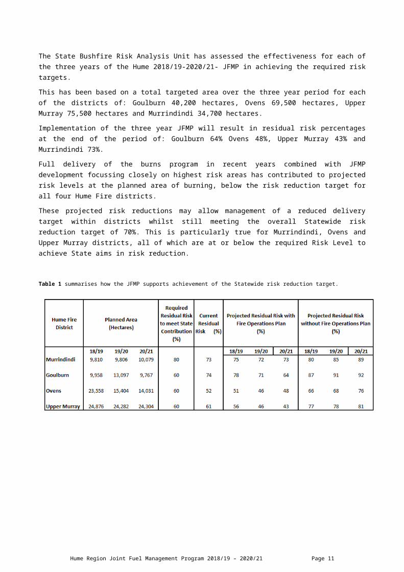
The State Bushfire Risk Analysis Unit has assessed the effectiveness for each of the three years of the Hume 2018/19-2020/21- JFMP in achieving the required risk targets.
This has been based on a total targeted area over the three year period for each of the districts of: Goulburn 40,200 hectares, Ovens 69,500 hectares, Upper Murray 75,500 hectares and Murrindindi 34,700 hectares.
Implementation of the three year JFMP will result in residual risk percentages at the end of the period of: Goulburn 64% Ovens 48%, Upper Murray 43% and Murrindindi 73%.
Hume Region Joint Fuel Management Program 2018/19 – 2020/21 Page 8

Full delivery of the burns program in recent years combined with JFMP development focussing closely on highest risk areas has contributed to projected risk levels at the planned area of burning, below the risk reduction target for all four Hume Fire districts.
These projected risk reductions may allow management of a reduced delivery target within districts whilst still meeting the overall Statewide risk reduction target of 70%. This is particularly true for Murrindindi, Ovens and Upper Murray districts, all of which are at or below the required Risk Level to achieve State aims in risk reduction.
Table 1 summarises how the JFMP supports achievement of the Statewide risk reduction target.
Hume Region Joint Fuel Management Program 2018/19 – 2020/21 Page 9

Modelled residual risk Hume Districts with and without planned burning.
The following graphs summarise how the JFMP supports achievement of the Statewide risk reduction target by fire district
Figure 1 – 4 District Risk Profiles.
Hume Region Joint Fuel Management Program 2018/19 – 2020/21 Page 10
Hume Region Joint Fuel Management Program 2018/19 – 2020/21 Page 11

Working with CommunitiesManaging bushfire risk is an ongoing and shared responsibility in which everyone has a role. To work well with communities to manage bushfire risk, DELWP operates under the principles of the DELWP Community Charter and CFA operates under the CFA Service Delivery Strategy 2015-2020.
In the Hume region, DELWP and CFA form partnerships with each other to work with communities, while each agency also maintains relationships with communities independent of each other. Under Safer Together, partnerships between DELWP, CFA, local government and other agencies will continue to be enhanced so that communities receive the best level of service.
DELWP and CFA undertake ongoing consultation with its communities, stakeholders and partners to develop the JFMP, including traditional owner groups, local government, industry groups such as vignerons, apiarists and tourism, community-based bushfire management groups and individual community members. Consultation helps fire agencies understand what risk means for them, the things people value, and the actions that can be collectively taken to create safer, more resilient communities and ecosystems. Stakeholders provide direct input at regional and district forums, events and meetings which have provided valuable input throughout the year. This local knowledge is incorporated into determining where planned burns take place, how they should be delivered and what values need protection. Where possible, feedback received at the end of the planned burning season is used in a constructive way to improve our planning and delivery functions.
Strategic fire planning conducted with the Hume region also identifies areas of private land and cross-tenure (public/private) bushfire risk areas, which are closely managed by DELWP and other relevant land managers and landholders. Each district in Hume region has at least one cross-tenure planned burn as a focus for community engagement and bushfire risk management. Under the Safer Together approach, fire agencies are involving local communities in decisions about bushfire management all year around to determine local solutions.
At the strategic level, the multi-agency Hume region Safer Together Coordinating Committee is working closely to map the current fire management planning processes for fuel management and community engagement to look for opportunities for improved alignment in its processes across agencies and to develop a shared understanding and utilisation of the tools for risk identification used to support joint bushfire planning in the region.
The delivery of the Hume planned burning program may have adverse impacts on the communities of Bright, Flowerdale, Hazeldene, Jamieson, Marysville, Nariel Valley, Tallangatta Valley and Yackandandah. DELWP and CFA will work closely with these communities and relevant stakeholders to manage potential impacts
Maintaining and Enhancing Ecosystem Resilience DELWP is committed to “maintain or improve the resilience of natural ecosystems and their ability to deliver services such as biodiversity, water, carbon storage and forest products” (the Code). Strategic bushfire management plans include consideration of ecosystem resilience at a strategic level over the long term, particularly how we can measure it. However, DELWP is working towards developing a more detailed understanding of how planned burning might impact flora and fauna, and how we can use fire to maintain and enhance ecosystem resilience into the future.
Ecological objectives and priorities
The regional objective for ecological resilience is to implement a balanced approach to fuel management activities across the landscape to ensure that ecosystem resilience is maintained or improved, and that the activities of fuel management generally does not have negative impacts on fire sensitive species and vegetation communities. The regional ecological objectives are documented in the Monitoring Evaluation and Reporting (MER) Plan 2016. Refer below for MER Metrics, Outcomes for Resilient Ecosystems.
Hume Region Joint Fuel Management Program 2018/19 – 2020/21 Page 12

Ecological priorities were identified that could be supported through planning and implementation of the current JFMP, and relevant spatial information and advice was provided to districts. The ecological priorities are:
To minimise areas scheduled for burning on the JFMP that are below minimum Tolerable Fire Interval. To avoid scheduling areas for burning that contain vegetation in older growth stages (Longest
Undisturbed vegetation). Avoid ignition and planned burning in Leadbeater’s Possum habitat and identify and protect colonies. To plan around other threatened and fire sensitive ecological communities and species, to avoid or
mitigate against potential impacts. To develop a JFMP with the primary focus in BMZ and APZ as the region transitions into a risk based
program.
MER Metrics Outcomes for Resilient Ecosystems
By 2022, Ecosystem resilience is not significantly impacted by fuel management activities by:
1. Maintaining more than 75% of the area of Forby Forest, Grassy|Heathy Dry Forest, Moist Forest and Tall Mist Forest in Landscape Management Zone (LMZ) within or above Tolerable Fire Interval
Table 2 - Percentage of identified Ecological Fire Groups (EFG) in LMZ currently above minimum TFI:
EFG % of EFG zoned LMZ % of EFG zoned LMZ on JFMP
Forby Forest 46 17
Grassy/Heathy Dry Forest 46 16
Moist Forest 25 4
Tall Mist Forest 1 7
2. Burning less than 10% of public land under Tolerable Fire Intervals
Hume region contains 3,854,206 hectares of land, 2,126,385 hectares of public land (PLM) and 1,466,392 of PLM is zoned under a FMZ.
Table 3 - JFMP as a percentage of public land below minimum TFI:
Year PLM FMZ %2018/19 1.70 2.50
2019/20 1.50 2.20
2020/21 1.20 1.70
3. Maintaining a minimum of 15% Longest Undisturbed for identified Ecological Fire Groups on public and private land.
Table 4 - % of EFG classified ‘Longest Undisturbed’ by District
District Forby Forest Grassy Heathy Dry Forest
Moist Forest Tall Mist Forest
Goulburn 23% 41% 61% 46%
Murrindindi 66% 92% 4% 0%
Ovens 7% 18% 0% 0.10%
Upper Murray 9% 15% 2% 0%
Tolerable Fire Interval and ecosystem resilience
Hume Region Joint Fuel Management Program 2018/19 – 2020/21 Page 13

Tolerable Fire Interval (TFI) is the current measure used to assess ecosystem resilience at a landscape level. When vegetation is within TFI, the risk to ecosystem resilience is reduced; the larger the area of our landscape either below minimum TFI or above maximum TFI, the less resilient ecosystems are likely to be. As a result of major bushfires in the last 15 years, there are large areas of vegetation within Hume region that are currently below minimum TFI.
Burning below TFI is justified in APZ and BMZ where risk to life and property is the top priority, but in LMZ the ecological risk of burning below minimum TFI should be given greater consideration. Full implementation of the JFMP in Hume will result in large areas being burnt while under minimum TFI in LMZ, refer to Table 5 for % of JFMP under TFI and Figure 5 for JFMP TFI status. The JFMP comprises of large areas of LMZ refer to Figure 6. These figures may change as the FMZ review is finalised in three of the fire districts.
Table 5 - % of JFMP under TFI and % of JFMP by FMZ.
% of JFMP under TFI by totals and by FMZ % of JFMP by FMZHUME 46LMZ 43 41BMZ 47 54APZ 54 2Goulburn 55LMZ 52 58BMZ 51 39APZ 57 1Murrindindi 77LMZ 59 21BMZ 80 74APZ 100 4Ovens 67LMZ 73 48BMZ 64 48APZ 58 0Upper Murray 16LMZ 9 39BMZ 19 57APZ 28 3
Figure 5 displays the TFI status over the JFMP
Hume Region Joint Fuel Management Program 2018/19 – 2020/21 Page 14

2019 Above Min TFI
Below Min TFI
No Fire
History
2020 Above Min TFI
Below Min TFI
No Fire
History
2021 Above Min TFI
Below Min TFI
No Fire
History
0
10
20
30
40
50
60
35
54
11
38
54
8
44 45
11
JFMP TFI %
Figure 6 displays FMZ status over the JFMP
2019 Other APZ BMZ LMZ 2020 Other APZ BMZ LMZ 2021 Other APZ BMZ LMZ0
10
20
30
40
50
60
51
56
38
2 3
5045
2 2
55
41
JFMP FMZ %
Vegetation Growth Stage Structure
DELWP land management aims to maintain a mix of Growth Stage Structure (GSS) across the landscape. The existing (interim) measure for Ecosystem Resilience is TFI, however Geometric Mean Abundance (GMA) is being developed as a future measure. Indications so far suggest that for this region, GMA is higher, and therefore Ecosystem Resilience is improved as large areas of vegetation continue to mature after the landscape scale bushfires. Vegetation in older growth stages also provides critical habitat for many threatened and fire-sensitive species and takes a long time to replace.
Similar to TFI trends, there are large areas of young vegetation in the Hume region as a result of bushfires in the last 15 years. Because the affected vegetation types take a relatively long time to reach maturity, there will continue to be a large proportion of younger vegetation for some time, increasing the importance of avoiding planned burning in areas of older growth stage vegetation. Areas of older growth stage vegetation were identified during JFMP development and are excluded where possible through operational and tactical planning. Full implementation of the current JFMP in Hume will result in decreasing areas of vegetation in the old growth stage.
Hume Region Joint Fuel Management Program 2018/19 – 2020/21 Page 15

Ecological burns
The total hectares of fuel management that is directed at ecological outcomes is 525 hectares totalling 10 burns. These are primarily for grassland and individual species management.
Threatened species and communities
Potential impacts on species and communities listed under the Commonwealth Environment Protection and Biodiversity Conservation Act 1999 (EPBC Act) or the Victorian Flora and Fauna Guarantee Act 1988 (FFG Act) have been addressed at the operational review of the draft JFMP. Records of listed species from the Victorian Biodiversity Atlas were used to identify potential conflicts with proposed burns and works. Advice has been provided regarding the potential nature of any impacts, along with recommendations to eliminate, mitigate or minimise potential threats to these values during planned burning. DELWP is currently developing a strategic assessment process to identify, assess and mitigate potential impacts of the planned burning program on matters of National Environmental Significance.
Ecological outcomes of the JFMP
The proposed 2019-2021 Hume planned burning program challenges ecological objectives and a reduced delivery target focused in BMZ and APZ would allow better management of ecosystem resilience. While effort has been made to address ecological priorities using the information provided, for example excluding some areas of Oldest Growth Stage vegetation from the JFMP, the transition to a risk-based JFMP, and the current review in Hume of the Fire Management Zoning scheme has still resulted in proposing burns in areas where ecological values will be compromised.
Hume Region Joint Fuel Management Program 2018/19 – 2020/21 Page 16

EndorsementThe 2018/19 – 2020/21 Joint Fuel Management Plan for the Hume region has been endorsed by:
DELWP Chief Fire Officer: Chris Hardman
CFA Chief Officer: Steve Warrington
Acting Assistant Chief Fire Officer, Jarrod Hayse Region: Hume
CFA Assistant Chief Officer, Ross Sullivan Region: North East
Noting for on ground ignition and delivery of cross tenure and private property burns, DELWP and CFA agency responsibilities remain unchanged.
Viewing the Hume Region Joint Fuel Management ProgramThe 2018/19 – 2020/21 Joint Fuel Management Plan for the Hume region can be viewed during normal business hours at the following office locations:
Location Address
Alexandra DELWP Office 5 Binns McCraes Road, Alexandra
Benalla DELWP Office 89 Sydney Road, Benalla
Corryong DELWP Office 6-8 Jardine Street, Corryong
Ovens DELWP Office 5338 Great Alpine Road, Ovens
Mansfield DELWP Office 128 Highett Street, Mansfield
Mitta Valley DELWP Office Omeo Hwy, Eskdale (by Appt)
Nathalia PV Office 71 Blake St, Nathalia (by Appt)
Tallangatta DELWP Office 34 Towong Street, Tallangatta (by Appt)
Wangaratta DELWP Office Cnr Ford & Ovens Streets, Wangaratta
Wodonga DELWP Office 1 McKoy Street, Wodonga
CFA District 12 Headquarters 39 McIntyre Street, Seymour
CFA District 13 Headquarters 18-22 Lakeview Drive, Lilydale
CFA District 22 Headquarters 195-205 Numurkah Road, Shepparton
CFA District 23 Headquarters 1 Ely Street, Wangaratta
CFA District 24 Headquarters 55 Moorefield Park Drive, Wodonga
Viewing the Plan online:You can view the Hume Joint Fuel Management Program online at:
http://www.ffm.vic.gov.au/bushfire-fuel-and-risk-management/fire-operation-plans
Hume Joint Fuel Management Program 2018/19 – 2020/21 Page 17

Upcoming burnsBurns that will be conducted within the next ten days (weather conditions permitting) can be viewed at:
http://www.ffm.vic.gov.au/bushfire-fuel-and-risk-management/planned-burns
You can also sign up to the Planned burning notification system (PBNS) and Vic Emergency App to receive automated SMS and email notifications about planned burns when they are close to being carried out.
How to become involved in the Joint Fuel Management Program DELWP and CFA welcome comment on fire management all year round, on all parts of the planning process – both strategic and operational. Please be aware that due to the planning cycle your comments relating to fire operations may be included in next year’s Joint Fuel Management Plan.
Comments and suggestions about DELWP and CFA fire management planning can be sent to:
DELWP Hume Region: Adam Green, Regional Fuel Management Coordinator, A│89 Sydney Rd Benalla, 3672. E│[email protected]
CFA North East Region, Darren Viney, Manager Community Safety, A│195-205 Numurkah Rd Shepparton 3630
Hume Region Joint Fuel Management Program 2018/19 – 2020/21 Page 18

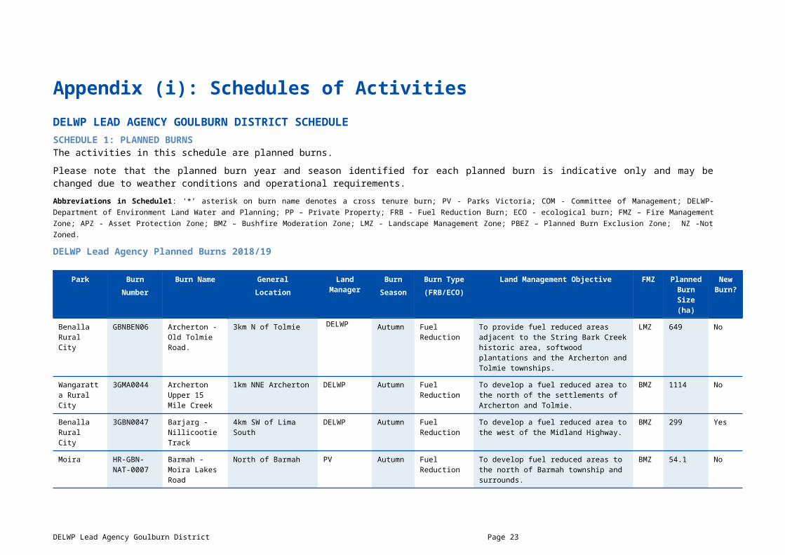
Appendix (i): Schedules of ActivitiesDELWP LEAD AGENCY GOULBURN DISTRICT SCHEDULESCHEDULE 1: PLANNED BURNS The activities in this schedule are planned burns.
Please note that the planned burn year and season identified for each planned burn is indicative only and may be changed due to weather conditions and operational requirements.
Abbreviations in Schedule1: ‘*’ asterisk on burn name denotes a cross tenure burn; PV - Parks Victoria; COM - Committee of Management; DELWP- Department of Environment Land Water and Planning; PP – Private Property; FRB - Fuel Reduction Burn; ECO - ecological burn; FMZ – Fire Management Zone; APZ - Asset Protection Zone; BMZ – Bushfire Moderation Zone; LMZ - Landscape Management Zone; PBEZ – Planned Burn Exclusion Zone; NZ -Not Zoned.
DELWP Lead Agency Planned Burns 2018/19
Park BurnNumber
Burn Name GeneralLocation
Land Manager
BurnSeason
Burn Type(FRB/ECO)
Land Management Objective FMZ Planned Burn
Size (ha)
New Burn?
Benalla Rural City
GBNBEN06 Archerton - Old Tolmie Road.
3km N of Tolmie DELWP Autumn Fuel Reduction
To provide fuel reduced areas adjacent to the String Bark Creek historic area, softwood plantations and the Archerton and Tolmie townships.
LMZ 649 No
Wangaratta Rural City
3GMA0044 Archerton Upper 15 Mile Creek
1km NNE Archerton DELWP Autumn Fuel Reduction
To develop a fuel reduced area to the north of the settlements of Archerton and Tolmie.
BMZ 1114 No
Benalla Rural City
3GBN0047 Barjarg - Nillicootie Track
4km SW of Lima South DELWP Autumn Fuel Reduction
To develop a fuel reduced area to the west of the Midland Highway.
BMZ 299 Yes
Moira HR-GBN-NAT-0007
Barmah - Moira Lakes Road
North of Barmah PV Autumn Fuel Reduction
To develop fuel reduced areas to the north of Barmah township and surrounds.
BMZ 54.1 No
Mansfield 3GMA0024 Barwite - Bakers Creek
5.5km N of Merrijig DELWP Autumn Fuel Reduction
To provide bushfire protection by reducing overall fuel hazard and bushfire hazard in the landscape
LMZ 990 No
Wangaratta Rural City
3GWG0023 Boorhaman - Boorhaman Native
19km N of Wangaratta PV Spring Ecological To modify the vegetation structure over the planned burn area to assist in the promotion
NZ 26.2 No
DELWP Lead Agency Goulburn District Page 19

Grassland of herbs, native grass species and orchids.
Mansfield HR-GBN-MAN-0022
Jamieson - Duncans Road South
1km N of Jamieson DELWP Autumn Fuel Reduction
To provide the highest level of localised protection to human life, property and community assets identified as highly valued including Jamieson township and surrounds.
APZ 59.6 No
Mansfield 3GMA0022 Jamieson West - Mt Terrible Track
1km W of Jamieson DELWP Autumn Fuel Reduction
To develop a fuel reduced corridor to the west of the Jamieson township.
LMZ 2442 No
Mansfield HR-GBN-MAN-0018
Matlock - Walhalla Road
2km SSW of Woods Point
DELWP Autumn Fuel Reduction
To develop fuel reduced areas to the south and east of Woods Point and Matlock and adjacent to the Melbourne Water catchments.
BMZ 724 Yes
Benalla Rural City
3GBN0026 Mt Samaria Butchers Track
14km SE of Swanpool PV Autumn Fuel Reduction
To develop fuel reduced areas of sufficient width and continuity to reduce the speed and intensity of bushfires.
BMZ 330 No
Moira HR-GBN-NAT-0008
Picola North - Gowers Track
8km NNW of Picola PV Autumn Fuel Reduction
To provide bushfire protection by reducing overall fuel hazard and bush fire hazard in the landscape.
NZ 33.2 No
Benalla Rural City
3GBN0020 Reef Hills - Johnson Rd
5km SW of Benalla PV Autumn Fuel Reduction
To provide bushfire protection by reducing overall fuel hazard and bushfire hazard in the landscape.
LMZ 260 No
Mansfield HR-GBN-MAN-0021
Sawmill Settlement - Plain Creek North
4km N of Sawmill Settlement
DELWP Autumn Fuel Reduction
To develop fuel reduced areas of sufficient width and continuity to reduce the speed and intensity of bushfires.
BMZ 352 No
Greater Shepparton City
3GSH0005 Shepparton North - Youngs Firewood Block
1.6km NW of Shepparton
PV Spring Fuel Reduction
To develop a fuel reduced area to the north and west of Shepparton and east of Mooroopna.
BMZ 120 No
Benalla Rural City
3GBN0006 Tatong - Watchbox Creek
8km E of Tatong DELWP Autumn Fuel Reduction
To develop fuel reduced areas of sufficient width and continuity to reduce the speed and intensity of bushfires.
BMZ 1184 No
Mansfield 3GMA0038 Tolmie South - Stockyard Creek
11km NE of Mansfield DELWP Autumn Fuel Reduction
To develop fuel reduced areas of sufficient width and continuity to reduce the speed and intensity of bushfires.
BMZ 1213 No
Wangaratta Rural City
3GWG0018 Wangaratta-Wangaratta
1.7km S of Wangaratta PV Spring Fuel Reduction
To provide bushfire protection outcomes by reducing overall fuel hazard and bushfire
LMZ 74.4 No
Hume Region Joint Fuel Management Program 2018/19 – 2020/21 Page 20

Common hazard in the landscape.
Benalla Rural City
GBNWAN01 Warby Ovens NP Wangandary Rd
4km SE of Boweya PV Autumn Fuel Reduction
To develop fuel reduced areas of sufficient width and continuity to reduce the speed and intensity of bushfires.
BMZ 488 No
Benalla Rural City
3GBN0048 Warrenbayne - Moonee Range West
4km SE of Warrenbayne
DELWP Autumn Fuel Reduction
To develop a fuel reduced area to the west of Lima and north of the Warrenbayne plantation
LMZ 253 Yes
Benalla Rural City
3GBN0037 Winton Wetland - Dam Wall Road
8km NE of Benalla COM Spring Ecological To modify the vegetation composition across the planned area to assist with the promotion and establishment of native species.
LMZ 174 No
Benalla Rural City
3GBN0038 Winton Wetland - Winton North Road Strategic Break
16km NE of Benalla COM Spring Fuel Reduction
To develop fuel reduced areas of sufficient width and continuity to reduce the speed and intensity of bushfires.
LMZ 90.8 No
Mansfield HR-GBR-MAN-0028
Woods Point - Dearlove Creek
2km NW of Woods Point
DELWP Autumn Fuel Reduction
To develop a fuel reduced area to the north west of Woods Point
LMZ 18 Yes
Hume Region Joint Fuel Management Program 2018/19 – 2020/21 Page 21

DELWP Lead Agency Planned Burns 2019/20
Local Governmen
t Area
BurnNumber
Burn Name GeneralLocation
Land Manager
BurnSeason
Burn Type(FRB/ECO)
Land Management Objective FMZ Planned Burn Size
(ha)
New Burn?
Greater Shepparton City
HR-GBN-SHP-0008
Arcadia - River Rd
1km NW of Arcadia PV Autumn Fuel Reduction
To develop a fuel reduced area to the west of Arcadia township
BMZ 8 No
Benalla Rural City
3GBN0009 Barjarg - Sandy Creek
Barjarg DELWP Autumn Fuel Reduction
To develop a fuel reduced area to the west of the Midlands Highway.
LMZ 2029 No
Moira 3GNA0018 Barmah NP- Gulf Tk Strategic
8km N of Picola PV Autumn Fuel Reduction
To develop fuel reduced areas adjacent to Gulf Track.
LMZ 63 No
Mansfield GBNMAN08 Blue Range Creek - Hat Hill North
6km N of Bridge Creek DELWP Autumn Fuel Reduction
To provide bushfire protection outcomes by reducing overall fuel hazard and bushfire hazard in the landscape.
LMZ 296 No
Moira 3GYA0001 Cobram East - Cobrawonga Track
5.7km SE of Cobram East
PV Autumn Fuel Reduction
To provide bushfire protection by reducing the overall fuel hazard and bushfire hazard in the landscape.
LMZ 50.7 No
Greater Shepparton City
3GSH0016 East Murchison Bush Reserve
3km E of Murchison COM Autumn Ecological To modify the vegetation structure across the planned area to assist the promotion of native grassland.
NZ 2 No
Benalla Rural City
HR-GBN-WAN-0016
Goomalibee NCR - Burness Rd
6.5km NW of Benalla PV Autumn Fuel Reduction
To modify the vegetation structure across the planned area to assist the promotion of native species (including orchids) and control of phalaris extent.
LMZ 182 No
Mansfield GBNMAN11 Jamieson North - Stony Creek
2.3km NE of Jamieson DELWP Autumn Fuel Reduction
To develop fuel reduced areas of sufficient width and continuity to reduce the speed and intensity of bushfires.
BMZ 2633 Yes
Mansfield 3GMA0045 Kevington Moonlight Spur
8km S of Jamieson DELWP Autumn Fuel Reduction
To provide bushfire protection outcomes by reducing overall fuel hazard and bushfire hazard in the landscape.
LMZ 6870 No
Wangaratta Rural City
HR-GBN-WAN-0015
Killawarra - Francis Rd
1km E of Killawarrra PV Autumn Fuel Reduction
To develop a fuel reduced corridor East West through the Warby - Ovens National Park
LMZ 29 No
Mansfield 3GBN0050 Mt Strathbogie - 6km W of Barjarg DELWP Autumn Fuel To provide a highest level of localised protection to LMZ 32 Yes
DELWP Lead Agency Goulburn District Page 22
Communication Towers
Reduction community assets identified as highly valued Communications Towers
Mansfield 3GMAN0051 Paps Communication Towers
9km W of Mansfield PV Autumn Fuel Reduction
To provide a highest level of localised protection to community assets identified as highly valued Communications Towers
LMZ 1 No
Wangaratta Rural City
3GWG0002 Peechelba - Peechelba Frosts
20km NW of Wangaratta PV Autumn Fuel Reduction
To develop fuel reduced area to the east of Peechelba.
LMZ 6.5 No
Moira 3GWG0017 Peechelba - Peechelba Road Strategic Break
3km NNE of Peechelba PV Autumn Fuel Reduction
To develop a fuel reduced area to the north of Peechelba and on either side of the Ovens River.
LMZ 16 No
Mansfield HR-GBN-MAN-0020
Sawmill Settlement - Delatite Education Area
2.5km SW of Sawmill Settlement
DELWP Autumn Fuel Reduction
To develop a fuel reduced area to the west of Sawmill Settlement.
BMZ 515 No
Greater Shepparton City
3GSH0012 Shepparton North - Mccrakens Track
10km NW of Shepparton PV Autumn Fuel Reduction
To develop a fuel reduced area to the west of high value infrastructure sites including treatment works.
LMZ 176 No
Benalla Rural City
3GBN0027 Toombullup West - Jones Track
14km SE of Swanpool DELWP Autumn Fuel Reduction
To develop fuel reduced areas of sufficient width and continuity to reduce the speed and intensity of bushfires. Provide some protection to adjacent plantations to the south.
BMZ 157 No
Moira HR-GBN-NAT-0010
Yeilima - Tullah Creek
7km N of Yeilima PV Autumn Fuel Reduction
To provide bushfire protection by reducing overall fuel hazard and bushfire hazard in the landscape.
LMZ 30 No
Hume Region Joint Fuel Management Program 2018/19 – 2020/21 Page 23

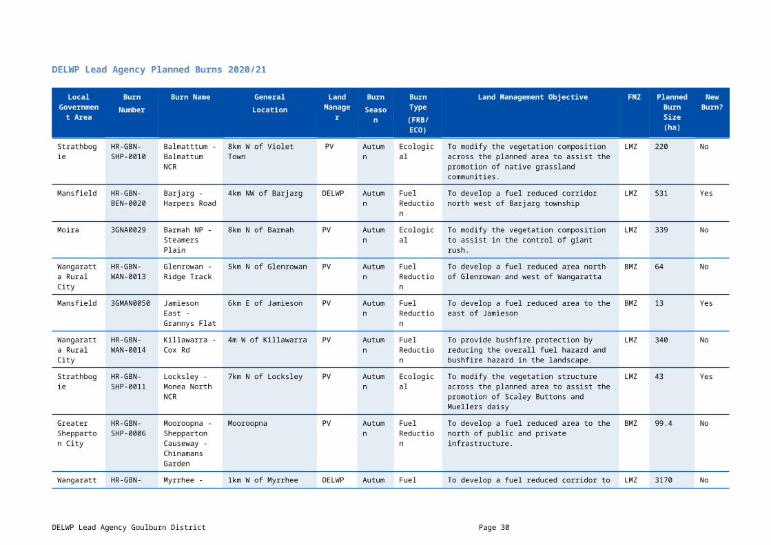
DELWP Lead Agency Planned Burns 2020/21
Local Governmen
t Area
BurnNumber
Burn Name GeneralLocation
Land Manager
BurnSeason
Burn Type(FRB/ECO)
Land Management Objective FMZ Planned Burn Size
(ha)
New Burn?
Strathbogie HR-GBN-SHP-0010
Balmatttum -Balmattum NCR
8km W of Violet Town PV Autumn Ecological To modify the vegetation composition across the planned area to assist the promotion of native grassland communities.
LMZ 220 No
Mansfield HR-GBN-BEN-0020
Barjarg - Harpers Road
4km NW of Barjarg DELWP Autumn Fuel Reduction
To develop a fuel reduced corridor north west of Barjarg township
LMZ 531 Yes
Moira 3GNA0029 Barmah NP - Steamers Plain
8km N of Barmah PV Autumn Ecological To modify the vegetation composition to assist in the control of giant rush.
LMZ 339 No
Wangaratta Rural City
HR-GBN-WAN-0013
Glenrowan - Ridge Track
5km N of Glenrowan PV Autumn Fuel Reduction
To develop a fuel reduced area north of Glenrowan and west of Wangaratta
BMZ 64 No
Mansfield 3GMAN0050 Jamieson East - Grannys Flat
6km E of Jamieson PV Autumn Fuel Reduction
To develop a fuel reduced area to the east of Jamieson
BMZ 13 Yes
Wangaratta Rural City
HR-GBN-WAN-0014
Killawarra - Cox Rd
4m W of Killawarra PV Autumn Fuel Reduction
To provide bushfire protection by reducing the overall fuel hazard and bushfire hazard in the landscape.
LMZ 340 No
Strathbogie HR-GBN-SHP-0011
Locksley - Monea North NCR
7km N of Locksley PV Autumn Ecological To modify the vegetation structure across the planned area to assist the promotion of Scaley Buttons and Muellers daisy
LMZ 43 Yes
Greater Shepparton City
HR-GBN-SHP-0006
Mooroopna - Shepparton Causeway - Chinamans Garden
Mooroopna PV Autumn Fuel Reduction
To develop a fuel reduced area to the north of public and private infrastructure.
BMZ 99.4 No
Wangaratta Rural City
HR-GBN-BEN-0029
Myrrhee - Middle Creek North
1km W of Myrrhee DELWP Autumn Fuel Reduction
To develop a fuel reduced corridor to the west of Myrrhee township.
LMZ 3170 No
Wangaratta Rural City
GBNBEN07 Myrrhee Madhouse Road
7km SW of Myrrhee DELWP Autumn Fuel Reduction
To develop a fuel reduced area to the north of Archerton and to the south of Myrrhee
LMZ 941 No
Moira HR-GBN-NAT-011
Nathalia - Barwo BR
2km N of Nathalia PV Autumn Fuel Reduction
To develop fuel reduced area to the north of Nathalia.
NZ 10.9 No
DELWP Lead Agency Goulburn District Page 24

Moira HR-GBN-SHP-009
Numurkah - Numurkah NCR
1km E of Numurkah PV Autumn Ecological To modify the vegetation composition across the planned area to assist the promotion of native species
NZ 11 No
Benalla Rural City
HR-GBN-MAN-0026
Samaria - Mt Joy
3km E of Samaria DELWP Autumn Fuel Reduction
To provide bushfire protection by reducing overall fuel hazard and bushfire hazard in the landscape.
LMZ 781 No
Benalla Rural City
HR-GBN-MAN-0027
Samaria - Williams Rd
6km SW of Samaria PV Autumn Fuel Reduction
To provide bushfire protection by reducing overall fuel hazard and bushfire hazard in the landscape.
BMZ 341 No
Greater Shepparton City
3GSH0013 Shepparton North - Reedy Swamp 1
5km NW of Shepparton PV Autumn Fuel Reduction
To develop a fuel reduced area north west of the Shepparton township
LMZ 227 No
Strathbogie 3GBN0052 Strathbogie South - Ruoaks Rd
10km SE of Strathbogie DELWP Autumn Fuel Reduction
To develop fuel reduced areas of sufficient width and continuity to reduce the speed and intensity of bushfires.
BMZ 491 Yes
Mansfield 3GBN0051 Strathbogie South - Tallangalook Rd
12km N of Bonnie Doon DELWP Autumn Fuel Reduction
To develop fuel reduced areas of sufficient width and continuity to reduce the speed and intensity of bushfires.
BMZ 253 Yes
Benalla Rural City
3GBN0045 Tatong - Mt Tatong
5km NE of Tatong DELWP Autumn Fuel Reduction
To provide bushfire protection by reducing overall fuel hazard and bushfire hazard in the landscape.
LMZ 287 No
Mansfield 3GBN0028 Toombullup South - Spring Creek Road
2km W of Tolmie DELWP Autumn Fuel Reduction
To provide bushfire protection by reducing overall fuel hazard and bushfire hazard in the landscape.
LMZ 406 No
Benalla Rural City
3GBN0049 Warrenbayne - Jones Hill
5km SE of Warrenbayne DELWP Autumn Fuel Reduction
To develop a fuel reduced area to the west of Lima and north of Warrenbayne plantation.
LMZ 206 Yes
Hume Region Joint Fuel Management Program 2018/19 – 2020/21 Page 25
SCHEDULE 2: NON-BURN FUEL TREATMENTS 2018/19 - DELWP Lead Agency The table below contains a summary of proposed non-burn fuel treatments over the following year. Some of these fuel treatments are annual, with others prioritised based on the seasonal conditions and which planned burns are scheduled. Accompanying maps provide detail on where these fuel treatment activities are located. Note that the maps show approximate areas only and the actual treatment area will be dependent on the condition of the fuels at the time of assessment. Please contact your local DELWP or Parks Victoria office if further detail is required.
Works by Land ManagerParks Victoria (ha)
DELWP(ha)
Other(ha)
Hectares Planned 320 356 57
SCHEDULE 3: NEW STRATEGIC FUELBREAKS 2018/19 - DELWP Lead Agency DELWP and Parks Victoria work together to establish and maintain a network of strategic fuelbreaks to expand the protection of communities, forests and parks from the risk of bushfire. A strategic fuelbreak is a strip of land where vegetation has been modified to reduce the amount of fuel available to burn during a bushfire. Strategic fuelbreaks are an important tool for fire management on public land. They provide a fuel-reduced area from which to conduct back burning ahead of an approaching bushfire or to assist in the implementation of a planned burn.
Machinery is used to clear vegetation generally within a 15-20-metre-wide strip. In some instances, this width could be up to 40m. Existing roads and tracks are considered part of the clearing. Where possible, trees are retained to provide shading and connection between the trees for wildlife and landscape values. The locations of strategic fuelbreaks are included for information only. These activities are approved via other DELWP and Parks Victoria processes. CFA strategic fuel breaks are included in Municipal Fire Management Plans.
Strategic fuel break maintenance is an annual program and included in Schedule 2 above.
There are no strategic fuel breaks scheduled for construction.
DELWP Lead Agency Goulburn District Page 26

DELWP LEAD AGENCY MURRINDINDI DISTRICT SCHEDULESCHEDULE 1: PLANNED BURNS The activities in this schedule are planned burns.
Please note that the planned burn year and season identified for each planned burn is indicative only and may be changed due to weather conditions and operational requirements.
Abbreviations in Schedule1: ‘*’ asterisk on burn name denotes a cross tenure burn; PV - Parks Victoria; COM - Committee of Management; DELWP- Department of Environment Land Water and Planning; PP – Private Property; FRB - Fuel Reduction Burn; ECO - ecological burn; FMZ – Fire Management Zone; APZ - Asset Protection Zone; BMZ – Bushfire Moderation Zone; LMZ - Landscape Management Zone; PBEZ – Planned Burn Exclusion Zone; NZ -Not Zoned.
DELWP Lead Agency Planned Burns 2018/19
Local Governmen
t Area
BurnNumber
Burn Name GeneralLocation
Land Manager
BurnSeason
Burn Type(FRB/ECO)
Land Management Objective FMZ Size (ha) New Burn?
Yarra Ranges
HRMURMVL43 Big River Pages 30km E of Marysville DELWP Autumn Fuel Reduction
To develop fuel reduced areas of sufficient width and continuity to reduce the spread of bushfire
BMZ 1850 Yes
Murrindindi HRMURMVL30 Big River SF - Eildon Warburton Rd
15km SE of Eildon DELWP Autumn Fuel Reduction
To develop fuel reduced areas of sufficient width and continuity to reduce the spread of bushfire
BMZ 162 No
Yarra Ranges
3MMV0008 Big River SF - Morris Rd
21km ESE of Marysville DELWP Autumn Fuel Reduction
To provide an irregular mosaic of areas of fuel reduction. To reduce the spread of Bushfire north of the Upper Yarra and Thomson catchments
BMZ 1212 No
Murrindindi 3MAL0003 Black Range Boundary Rd
5km E of Limestone DELWP Autumn Fuel Reduction
To provide an irregular mosaic of areas of fuel reduction.
BMZ 122 No
Murrindindi 3MAL0005 Black Range Hedger Tk
11km SW of Alexandra DELWP Autumn Fuel Reduction
To provide an irregular mosaic of areas of fuel reduction.
BMZ 1027 No
Murrindindi HRMURALX27 Black Range Mill Creek Rd
6km SW of Taggerty DELWP Autumn Fuel Reduction
To develop fuel reduced areas of sufficient extent and continuity to reduce the spread of bushfire and assist control efforts.
BMZ 125 No
Murrindindi HRMURTLG19 Buxton - Left Track
3km SW of Buxton DELWP Autumn Fuel Reduction
To develop fuel reduced areas of sufficient width and continuity to reduce the spread of bushfire
BMZ 74 No
Murrindindi 3MKL0018 Castella 2.5km W of Castella PV Autumn Fuel To develop fuel reduced areas of sufficient BMZ 272 No
DELWP Lead Agency Murrindindi District Page 27

Healesville Kinglake Rd
Reduction width and continuity to reduce the spread of bushfire
Murrindindi 3MTL0014 Castella Marginal Rd B
4km SE of Glenburn DELWP Autumn Fuel Reduction
To provide an irregular mosaic of areas of fuel reduction.
BMZ 605 No
Mansfield 3MAL0009 Enochs Point Railway Creek
10km SSW of Jamieson & 6km SSW of Kevington
DELWP Autumn Fuel Reduction
To provide an irregular mosaic of areas of fuel reduction.
LMZ 1085 No
Mitchell 3MBD0018 Flowerdale Mullers Creek Rd
Flowerdale DELWP Autumn Fuel Reduction
To develop fuel reduced areas of sufficient width and continuity to reduce the spread of bushfire.
BMZ 486 No
Murrindindi 3MMV0017 Granton Pitt Tk 200m N of Granton 4.5km W of Marysville
DELWP Autumn Fuel Reduction
To provide protection to human life, property and highly valued assets of the Granton and Marysville communities.
LMZ 16.5 No
Murrindindi HRMURTLG22 Hazeldene - Long Gully Rd
2km E of Hazeldene DELWP Autumn Fuel Reduction
To develop fuel reduced areas of sufficient width and continuity to reduce the spread of bushfire.
BMZ 142 No
Mitchell HRMURBRD47 Hazeldene Road 30
2.4km WSW of Hazeldene
PV Autumn Fuel Reduction
To develop fuel reduced areas of sufficient width and continuity to reduce the spread of bushfire and
BMZ 48.2 No
Mitchell HRMURKLN24 Hazeldene Road 36
4km W of Hazeldene PV Autumn Fuel Reduction
To develop fuel reduced areas of sufficient width and continuity to reduce the spread of bushfire.
BMZ 114 No
Murrindindi HRMURMVL33 Marysville - Southern Tk
1km S of Marysville DELWP Autumn Fuel Reduction
To provide a high level of strategic protection to human life, property and highly valued assets in and around the Marysville township.
BMZ 34 No
Murrindindi 3MMV0028 Marysville Nanda Binya
Marysville Township DELWP Autumn Fuel Reduction
To provide a high level of strategic protection to human life, property and highly valued assets
APZ 4 No
Murrindindi HRMURMVL37 Marysville Perrys Tk
5km N of Marysville DELWP Autumn Fuel Reduction
To develop fuel reduced areas of sufficient width and continuity to reduce the spread of bushfire.
BMZ 389 No
Murrindindi 3MMV0018 Marysville Red Hill West
500m NE of Marysville DELWP Autumn Fuel Reduction
To provide protection to human life, property and highly valued assets of Marysville township.
APZ 26 No
Murrindindi 3MTL0006 Mt Robertson 8.5km NW of Glenburn DELWP Autumn Fuel To develop fuel reduced areas of sufficient BMZ 519 No
Hume Region Joint Fuel Management Program 2018/19 – 2020/21 Page 28

Boggy Crk Rd Reduction width and continuity to reduce the spread of bushfire.
Murrindindi 3MTL0007 Murrindindi Horseyard Crk Tk
4.5km SE of Devlins Bridge
DELWP Autumn Fuel Reduction
To develop fuel reduced areas of sufficient width and continuity to reduce the spread of bushfire
BMZ 543 No
Murrindindi 3MMV0014 Narbethong South Dom Dom Rd
Immediately South of Narbethong Township
DELWP Autumn Fuel Reduction
To provide a high level of strategic protection to human life, property and assets of Narbethong.
BMZ 45 No
Murrindindi 3MTL0018 Pheasant Crk Watsons Rd
2.5km N of Pheasant Creek
DELWP Autumn Fuel Reduction
To develop fuel reduced areas of sufficient width and continuity to reduce the spread of bushfire
BMZ 228.5 No
Murrindindi 3MAL0012 Rubicon SF South Cordurory Crk Rd A
10.5km SSE of Snobs Creek
DELWP Autumn Fuel Reduction
To develop fuel reduced areas of sufficient width and continuity to reduce the spread of bushfire.
BMZ 318 No
Mitchell 3MBD0003 Tallarook SF Trawool Reservoir East B
8km E of Tallarook DELWP Autumn Fuel Reduction
To provide an irregular mosaic of areas of fuel reduction which will complement works in adjacent fuel management zones.
LMZ 226 No
Mitchell HRMURBRD38 Tallarooks Freemans Rd
8km SE of Tallarook DELWP Autumn Fuel Reduction
To develop fuel reduced areas of sufficient width and continuity to reduce the spread of bushfire.
BMZ 64 No
Mitchell HRMURBRD48 Tallarooks Gravel Pit
10km SE of Tallarook DELWP Autumn Fuel Reduction
To develop fuel reduced areas of sufficient width and continuity to reduce the spread of bushfire
BMZ 62 Yes
Strathbogie 3MLE0017 Terip Terip Rd Candling
2km W of Gobur PV Winter Fuel Reduction
To reduce the bark hazard, while maintaining ecological processes.
LMZ 10.3 No
DELWP Lead Agency Murrindindi District Page 29
DELWP Lead Agency Planned Burns 2019/20
Local Government
Area
BurnNumber
Burn Name GeneralLocation
Land Manager
BurnSeason
Burn Type(FRB/ECO)
Land Management Objective FMZ Planned Burn Size
(ha)
New Burn?
Murrindindi HRMURMVL44 Big River Vans Rd
20km ENE of Marysville DELWP Autumn Fuel Reduction
To develop fuel reduced areas of sufficient width and continuity to reduce the spread of bushfire
BMZ 399 Yes
Murrindindi HRMURALX34 Black Range - McDonald Break
7km SE of Limestone DELWP Autumn Fuel Reduction
To develop fuel reduced areas of sufficient width and continuity to reduce the spread of bushfire
BMZ 680 No
Murrindindi HRMURALX23 Black Range Barry Road
7km NW of Buxton DELWP Autumn Fuel Reduction
To develop fuel reduced areas of sufficient width and continuity to reduce the spread of uncontrolled bushfire
BMZ 458 No
Murrindindi 3MAL0002 Black Range Ginter Rd
14km S of Molesworth DELWP Autumn Fuel Reduction
To provide an irregular mosaic of areas of fuel reduction.
BMZ 596 No
Murrindindi HRMURALX28 Black Range North Eastern Rd
11km W of Taggerty DELWP Autumn Fuel Reduction
To develop fuel reduced areas of sufficient extent and continuity to reduce the spread of bushfire.
LMZ 837 No
Murrindindi 3MTL0010 Castella Marginal Rd A
4.5km SE of Glenburn DELWP Autumn Fuel Reduction
To provide an irregular mosaic of areas of fuel reduction.
BMZ 553 No
Mitchell HRMURBRD28 Clonbinane - Main Mountain Rd
5km E of Clonbinane DELWP Autumn Fuel Reduction
To develop fuel reduced areas of sufficient width and continuity to reduce the spread of bushfire and augment adjacent fuel management activities.
LMZ 92 No
Mitchell HRMURBRD27 Clonbinane Escreets Rd
6km SE of Clonbinane DELWP Autumn Fuel Reduction
To develop fuel reduced areas of sufficient extent and continuity to reduce the spread of bushfire and augment adjacent burns.
BMZ 408 No
Mitchell HRMURBRD29 Clonbinane Quarry Rd
4km E of Clonbinane DELWP Autumn Fuel Reduction
To develop fuel reduced areas of sufficient width and continuity to reduce the spread of bushfire
LMZ 408 No
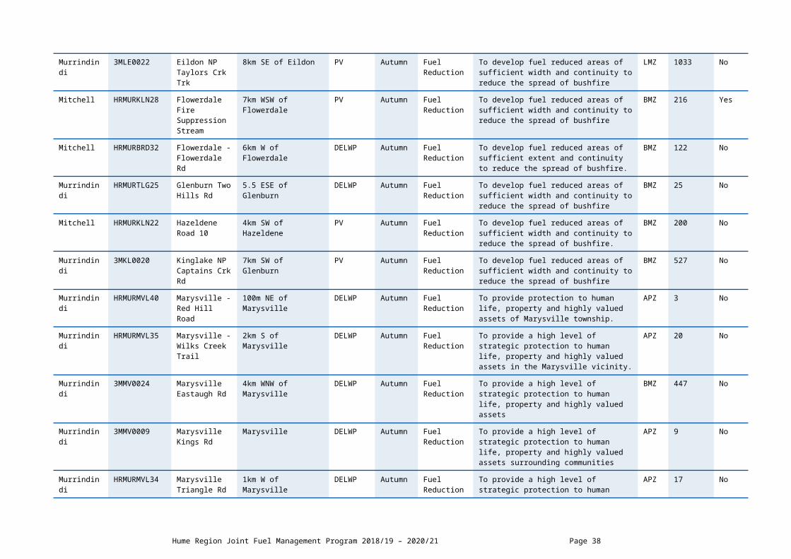
Murrindindi 3MLE0022 Eildon NP Taylors Crk Trk
8km SE of Eildon PV Autumn Fuel Reduction
To develop fuel reduced areas of sufficient width and continuity to reduce the spread of bushfire
LMZ 1033 No
Mitchell HRMURKLN28 Flowerdale Fire Suppression
7km WSW of PV Autumn Fuel To develop fuel reduced areas of sufficient width and continuity to reduce the spread of
BMZ 216 Yes
Hume Region Joint Fuel Management Program 2018/19 – 2020/21 Page 30

Stream Flowerdale Reduction bushfire
Mitchell HRMURBRD32 Flowerdale - Flowerdale Rd
6km W of Flowerdale DELWP Autumn Fuel Reduction
To develop fuel reduced areas of sufficient extent and continuity to reduce the spread of bushfire.
BMZ 122 No
Murrindindi HRMURTLG25 Glenburn Two Hills Rd
5.5 ESE of Glenburn DELWP Autumn Fuel Reduction
To develop fuel reduced areas of sufficient width and continuity to reduce the spread of bushfire
BMZ 25 No
Mitchell HRMURKLN22 Hazeldene Road 10
4km SW of Hazeldene PV Autumn Fuel Reduction
To develop fuel reduced areas of sufficient width and continuity to reduce the spread of bushfire.
BMZ 200 No
Murrindindi 3MKL0020 Kinglake NP Captains Crk Rd
7km SW of Glenburn PV Autumn Fuel Reduction
To develop fuel reduced areas of sufficient width and continuity to reduce the spread of bushfire
BMZ 527 No
Murrindindi HRMURMVL40 Marysville - Red Hill Road
100m NE of Marysville DELWP Autumn Fuel Reduction
To provide protection to human life, property and highly valued assets of Marysville township.
APZ 3 No
Murrindindi HRMURMVL35 Marysville - Wilks Creek Trail
2km S of Marysville DELWP Autumn Fuel Reduction
To provide a high level of strategic protection to human life, property and highly valued assets in the Marysville vicinity.
APZ 20 No
Murrindindi 3MMV0024 Marysville Eastaugh Rd
4km WNW of Marysville DELWP Autumn Fuel Reduction
To provide a high level of strategic protection to human life, property and highly valued assets
BMZ 447 No
Murrindindi 3MMV0009 Marysville Kings Rd
Marysville DELWP Autumn Fuel Reduction
To provide a high level of strategic protection to human life, property and highly valued assets surrounding communities
APZ 9 No
Murrindindi HRMURMVL34 Marysville Triangle Rd
1km W of Marysville DELWP Autumn Fuel Reduction
To provide a high level of strategic protection to human life, property and highly valued assets in the Marysville vicinity.
APZ 17 No
Mitchell HRMURTLG24 Mt Disappointment SF Road 24
8km N of Kinglake West DELWP Autumn Fuel Reduction
To develop fuel reduced areas of sufficient extent and continuity to reduce the spread of bushfire.
BMZ 37 No
Murrindindi HRMURTLG20 Mt Robertson Battery Spur
10km N of Pheasant Creek
DELWP Autumn Fuel Reduction
To develop fuel reduced areas of sufficient width and continuity to reduce the spread of bushfire.
LMZ 98 No
Murrindindi HRMURTLG21 Mt Robertson 8km N of Kinglake West DELWP Autumn Fuel To develop fuel reduced areas of sufficient BMZ 528 No
DELWP Lead Agency Murrindindi District Page 31

Boggy Spur Tk Reduction width and continuity to reduce the spread of bushfire.
Mitchell 3MBD0022 Reedy Creek Leviathan Rd
3km S of Reedy Creek DELWP Autumn Fuel Reduction
To develop fuel reduced areas of sufficient width and continuity to reduce the spread of bushfire
APZ 93 No
Mitchell HRMURBRD34 Reedy Creek Peels Rd
3km S of Reedy Creek DELWP Autumn Fuel Reduction
To develop fuel reduced areas of sufficient extent and continuity to reduce the spread of bushfire.
BMZ 105 No
Murrindindi 3MAL0020 Rubicon SF South Cordurory Crk Rd B
10.5 km SSE of Snobs Creek
DELWP Autumn Fuel Reduction
To develop fuel reduced areas of sufficient width and continuity to reduce the spread of bushfire.
BMZ 226 No
Mitchell 3MBD0011 Tallarook SF Flat Rock Tk
9.5km NNE of Broadford
DELWP Autumn Fuel Reduction
To develop fuel reduced areas of sufficient width and continuity to reduce the spread of bushfire.
BMZ 168 No
Mitchell 3MBD0019 Tallarook SF Flynns Rd B
5km N of Strath Creek DELWP Autumn Fuel Reduction
To develop fuel reduced areas of sufficient width and continuity to reduce the spread of bushfire.
BMZ 83 No
Mitchell 3MBD0012 Tallarook SF Trawool Reservoir West
5km E of Tallarook DELWP Autumn Fuel Reduction
To develop fuel reduced areas of sufficient width and continuity to reduce the spread of bushfire and offer protection to the popular recreation site at Trawool reservoir.
LMZ 269 No
Mitchell HRMURBRD40 Tallarooks - Mountain Tk
10km SE of Tallarook DELWP Autumn Fuel Reduction
To provide a high level of strategic protection to human life, property and highly valued assets.
BMZ 49 No
Mitchell HRMURBRD37 Tallarooks Freemans Link Rd
9km SE of Tallarook DELWP Autumn Fuel Reduction
To develop fuel reduced areas of sufficient width and continuity to reduce the spread of bushfire.
BMZ 111 No
Murrindindi HRMURMVL36 Taponga Rough Hill Rd
28km S of Eildon DELWP Autumn Fuel Reduction
To develop fuel reduced areas of sufficient width and continuity to reduce the spread of bushfire.
BMZ 560 No
Murrindindi 3MTL0009 Toolangi Old Toolangi Rd
Toolangi Township PV Autumn Fuel Reduction
To provide a high level of strategic protection to human life, property and highly valued assets of Toolangi.
LMZ 6.2 No
Mitchell HRMURBRD41 Wandong Dry Creek Rd
3km E of Wandong PV Autumn Fuel Reduction
To provide a high level of strategic protection to human life, property and highly valued assets of Wandong and Heathcote Junction.
APZ 384 No
Hume Region Joint Fuel Management Program 2018/19 – 2020/21 Page 32

Mitchell HRMURBRD42 Wandong South Mountain Rd
4 Km ESE Heathcote Junction
PV Autumn Fuel Reduction
To provide a high level of strategic protection to human life, property and highly valued assets in and around Heathcote Junction and Wandong townships.
APZ 36 No
DELWP Lead Agency Murrindindi District Page 33

DELWP Lead Agency Planned Burns 2020/21
Local Government
Area
BurnNumber
Burn Name GeneralLocation
Land Manager
BurnSeason
Burn Type(FRB/ECO)
Land Management Objective FMZ Planned Burn
Size (ha)
New Burn?
Murrindindi HRMURALX35 Big River SF Sabrina Tk
14km SSW of Jamieson
DELWP Autumn Fuel Reduction
To develop fuel reduced areas of sufficient width and continuity to reduce the spread of bushfire
BMZ 1441 Yes
Murrindindi HRMURALX26 Black Range - Ingrams Rd
11km W of Taggerty DELWP Autumn Fuel Reduction
To develop fuel reduced areas of sufficient extent and continuity to reduce the spread of bushfire.
LMZ 523 No
Murrindindi HRMURALX33 Black Range - Simmond Track
5km SE of Limestone DELWP Autumn Fuel Reduction
To develop fuel reduced areas of sufficient width and continuity to reduce the spread of bushfire
BMZ 199 No
Murrindindi HRMURALX29 Black Range - Whanregararwen
12km SW of Alexandra
DELWP Autumn Fuel Reduction
To provide a high level of protection to life and property in this area, particularly with respect to fire from the SW.
LMZ 139 No
Murrindindi HRMURALX24 Black Range Ginters Break
13km NW of Taggerty DELWP Autumn Fuel Reduction
To develop fuel reduced areas of sufficient dimension and continuity to reduce the spread of bushfire and complement other scheduled burns in the vicinity.
BMZ 496 No
Murrindindi HRMURALX25 Black Range Higginbotham Tk
7km NE of Murrindindi DELWP Autumn Fuel Reduction
To develop fuel reduced areas of sufficient dimension and continuity to reduce the spread of bushfire and complement other scheduled burns in the vicinity.
BMZ 302 No
Murrindindi HRMURALX30 Black Range Whiting Break
8km SW of Taggerty DELWP Autumn Fuel Reduction
To provide a system of burns of sufficient extent and continuity to reduce fire intensity and aid suppression in the Black Range
BMZ 106 No
Mansfield 3MLE0001 Bonniedoon Maintongoon Rd
9.5km NW of Eildon PV Autumn Fuel Reduction
To provide an irregular mosaic of areas of fuel reduction.
LMZ 510 No
Murrindindi 3MAL0022 Buxton Tin Creek Tk
3.5km NW of Buxton VESTED VPC
Autumn Fuel Reduction
To develop fuel reduced areas of sufficient width and continuity to reduce the spread of bushfire
NZ 135 No
Hume Region Joint Fuel Management Program 2018/19 – 2020/21 Page 34

Murrindindi 3MTL0005 Castella Melba Hwy A
5km NW of Toolangi DELWP Autumn Fuel Reduction
To provide a high level of strategic protection to human life, property and highly valued assets in and around Castella and Toolangi.
BMZ 312 No
Murrindindi 3MTL0015 Castella Melba Hwy B
5km NW of Toolangi DELWP Autumn Fuel Reduction
To provide a high level of strategic protection to human life, property and highly valued assets in and around Castella and Toolangi.
BMZ 266 No
Mitchell HRMURBRD43 Clonbinane - Boundary Road
3km SE of Clonbinane DELWP Autumn Fuel Reduction
To establish a fuel reduced area of sufficient extent and continuity to aid in safe bushfire suppression and enhance protection to the nearby community.
BMZ 162 No
Mitchell HRMURBRD26 Clonbinane Drag Hill Rd
4km S of Clonbinane PV Autumn Fuel Reduction
To provide a high level of strategic protection to human life, property and highly valued assets in the Wandong, Heathcote Junction and Clonbinane vicinities
APZ 126 No
Mitchell HRMURBRD30 Clonbinane Two Tees Rd
6.5km E of Clonbinane
DELWP Autumn Fuel Reduction
To develop fuel reduced areas of sufficient width and continuity to reduce the spread of bushfire
BMZ 256 No
Mitchell HRMURBRD31 Flowerdale Digger Gully Rd
7km W of Flowerdale DELWP Autumn Fuel Reduction
To develop fuel reduced areas of sufficient extent and continuity to reduce the spread of bushfire.
BMZ 300 No
Mitchell HRMURBRD49 Flowerdale Firewood No 2 Tk
3.8km NNW of Hazeldene
DELWP Autumn Fuel Reduction
To develop fuel reduced areas of sufficient width and continuity to reduce the spread of bushfire
BMZ 72 Yes
Mitchell HRMURBRD450
Flowerdale Silver Crk North
4.3km NNW of Hazeldene
DELWP Autumn Fuel Reduction
To develop fuel reduced areas of sufficient width and continuity to reduce the spread of bushfire
BMZ 323 Yes
Mitchell HRMURKLN23 Hazeldene Road 34
4km SE of Hazeldene PV Autumn Fuel Reduction
To develop fuel reduced areas of sufficient width and continuity to reduce the spread of bushfire.
BMZ 70 No
DELWP Lead Agency Murrindindi District Page 35

Mitchell 3MKL0021 Hazeldene Road 7
4km SSW of Hazeldene
PV Autumn Fuel Reduction
To develop fuel reduced areas of sufficient width and continuity to reduce the spread of bushfire
BMZ 25 Yes
Mansfield HRMURALX36 Jamieson Lake Tk
8km NNW of Jamieson
PV Autumn Fuel Reduction
To develop fuel reduced areas of sufficient width and continuity to reduce the spread of bushfire
BMZ 1667 Yes
Murrindindi HRMURKLN29 Kinglake Andrews Hill
6km NNE of Kinglake PV Autumn Fuel Reduction
To develop fuel reduced areas of sufficient width and continuity to reduce the spread of bushfire
LMZ 410 Yes
Murrindindi HRMURKLN26 Kinglake NP Candlebark Tk
9km N of Kinglake PV Autumn Fuel Reduction
To develop fuel reduced areas of sufficient width and continuity to reduce the spread of bushfire.
LMZ 223 No
Murrindindi HRMURMVL39 Marysville Church Hill
Northern edge of Marysville township
DELWP Autumn Fuel Reduction
To develop fuel reduced areas of sufficient width and continuity to reduce the spread of bushfire
APZ 18 No
Murrindindi HRMURMVL41 Marysville Gilberts Gully
SW edge of Marysville township
DELWP Autumn Fuel Reduction
To provide a high level of strategic protection to human life, property and highly valued assets of the Marysville township
APZ 17 No
Murrindindi 3MMV0019 Marysville Mt Gordon Tower
4km NW of Marysville DELWP Autumn Fuel Reduction
To provide protection to human life, property and highly valued assets of Marysville township.
APZ 12.6 No
Murrindindi 3MMV0029 Marysville Paradise Plains Rd
Southern end of Marysville township
COM Autumn Fuel Reduction
To provide a high level of strategic protection to human life, property and highly valued assets in the Marysville township
APZ 19 No
Murrindindi 3MMV0020 Marysville Tip Hill South
Marysville township DELWP Autumn Fuel Reduction
To provide protection to human life, property and highly valued assets within Marysville township
APZ 35 No
Murrindindi HRMURTLG23 Murrindindi Mt Despair Rd
11km NE of Glenburn DELWP Autumn Fuel Reduction
To develop fuel reduced areas of sufficient width and continuity to reduce the spread of bushfire.
BMZ 243 No
Nillumbik HRMURKLN25 Pheasant Creek Mt Sugarloaf Rd
5km S of Kinglake West
PV Autumn Fuel Reduction
To develop fuel reduced areas of sufficient width and continuity to reduce the spread of bushfire.
BMZ 349 No
Hume Region Joint Fuel Management Program 2018/19 – 2020/21 Page 36

Mitchell HRMURBRD44 Reedy Creek Doctors Link Tk
4km S of Reedy Creek DELWP Autumn Fuel Reduction
To provide a high level of strategic protection to human life, property and highly valued assets in the Reedy Creek vicinity.
APZ 174 No
Mitchell HRMURBRD33 Reedy Creek Murchison Rd
5km SE of Reedy Creek
DELWP Autumn Fuel Reduction
To develop fuel reduced areas of sufficient width and continuity to reduce the spread of bushfire.
BMZ 165 No
Mitchell HRMURBRD35 Reedy Creek Tonsil Rd
4km SE of Reedy Creek
DELWP Autumn Fuel Reduction
To develop fuel reduced areas of sufficient width and continuity to reduce the spread of bushfire.
BMZ 72 No
Nillumbik 3MKL0004 St Andrews Buttermans Tk
5.5km E of St Andrews
PV Autumn Fuel Reduction
To provide an irregular mosaic of areas of fuel reduction adjacent to the large area of forest to the north affected by the 2009 bushfire.
BMZ 331 Yes
Mitchell 3MBD0024 Tallarook SF Flynns Rd C
5km N of Strath Creek DELWP Autumn Fuel Reduction
To develop fuel reduced areas of sufficient width and continuity to reduce the spread of bushfire.
BMZ 142 No
Mitchell 3MBD0025 Tallarook SF Trawool Reservoir East A
8km E of Tallarook DELWP Autumn Fuel Reduction
To provide an irregular mosaic of areas of fuel reduction which will complement works in adjacent fuel management zones.
LMZ 229 No
Mitchell HRMURBRD36 Tallarooks - Wheelers Tk
8km SE of Tallarook DELWP Autumn Fuel Reduction
To develop fuel reduced areas of sufficient width and continuity to reduce the spread of bushfire.
BMZ 106 No
Mitchell HRMURBRD39 Tallarooks Magazine Tk
10km SE of Tallarook DELWP Autumn Fuel Reduction
To develop fuel reduced areas of sufficient width and continuity to reduce the spread of bushfire.
BMZ 103 Yes
DELWP Lead Agency Murrindindi District Page 37
SCHEDULE 2: NON-BURN FUEL TREATMENTS 2018/19 - DELWP Lead Agency The table below contains a summary of proposed non-burn fuel treatments over the following year. Some of these fuel treatments are annual, with others prioritised based on the seasonal conditions and which planned burns are scheduled. Accompanying maps provide detail on where these fuel treatment activities are located. Note that the maps show approximate areas only and the actual treatment area will be dependent on the condition of the fuels at the time of assessment. Please contact your local DELWP or Parks Victoria office if further detail is required.
Works by Land ManagerParks Victoria (ha)
DELWP(ha)
Other(ha)
Hectares Planned 201 455 183
SCHEDULE 3: NEW STRATEGIC FUELBREAKS 2018/19 - DELWP Lead Agency DELWP and Parks Victoria work together to establish and maintain a network of strategic fuelbreaks to expand the protection of communities, forests and parks from the risk of bushfire. A strategic fuelbreak is a strip of land where vegetation has been modified to reduce the amount of fuel available to burn during a bushfire. Strategic fuelbreaks are an important tool for fire management on public land. They provide a fuel-reduced area from which to conduct back burning ahead of an approaching bushfire or to assist in the implementation of a planned burn.
Machinery is used to clear vegetation generally within a 15-20-metre-wide strip. In some instances, this width could be up to 40m. Existing roads and tracks are considered part of the clearing. Where possible, overstorey trees are retained to provide shading and connection between the trees for wildlife and landscape values. The locations of strategic fuelbreaks are included for information only. These activities are approved via other DELWP and Parks Victoria processes. CFA strategic fuel breaks are included in Municipal Fire Management Plans.
Strategic fuel break maintenance is an annual program and included in Schedule 2 above.
There are no strategic fuel breaks scheduled for construction.

DELWP LEAD AGENCY OVENS DISTRICT SCHEDULESCHEDULE 1: PLANNED BURNS The activities in this schedule are planned burns.
Please note that the planned burn year and season identified for each planned burn is indicative only and may be changed due to weather conditions and operational requirements.
Abbreviations in Schedule1: ‘*’ asterisk on burn name denotes a cross tenure burn; PV - Parks Victoria; COM - Committee of Management; DELWP- Department of Environment Land Water and Planning; PP – Private Property; FRB - Fuel Reduction Burn; ECO - ecological burn; FMZ – Fire Management Zone; APZ - Asset Protection Zone; BMZ – Bushfire Moderation Zone; LMZ - Landscape Management Zone; PBEZ – Planned Burn Exclusion Zone; NZ -Not Zoned.
DELWP Lead Agency Planned Burns 2018/19
Local Governmen
t Area
BurnNumber
Burn Name GeneralLocation
Land Manager
BurnSeason
Burn Type(FRB/ECO)
Land Management Objective FMZ Planned Burn Size
(ha)
New Burn?
Wodonga City
HR-OVE-BEE-0005
Baranduda - Trig Point Track
12km SW of Wodonga PV Autumn Fuel Reduction
To develop fuel reduced areas of sufficient width and continuity to reduce the spread of bushfire.
BMZ 1026 No
Wodonga City
HR-OVE-BEE-0004
Baranduda - Wrens Stringybark Block
10km SE of Wodonga COM Spring Ecological To reduce overall grass biomass: Themeda Triandra within designated burn units and annual grass species.
NZ 9.4 No
Indigo HR-OVE-BEE-0013
Beechworth - Correctional Centre
2km W of Beechworth PV Autumn Fuel Reduction
To provide a high level of strategic protection to human life, property and highly valued assets.
APZ 514.1 No
Indigo HR-OVE-BEE-0008
Beechworth - Magpie No 1
3km NE of Beechworth DELWP Autumn Fuel Reduction
To develop fuel reduced areas of sufficient width and continuity to reduce the spread of bushfire and threat to assets and property
BMZ 166 No
Alpine HR-OVE-BRT-0006
Buckland Valley - Devils Creek
15km SW of Bright DELWP Autumn Fuel Reduction
To provide an irregular mosaic of areas of fuel reduction which will complement works in adjacent fuel management zones
BMZ 8712 No
Wangaratta Rural City
HR-OVE-MYT-0002
Carboor - Carboor Range South
12km NE of Whitfield DELWP Autumn Fuel Reduction
To develop fuel reduced areas of sufficient width and continuity to reduce the spread of bushfire and threat to assets and property
LMZ 403 No
Wangaratta Rural City
HR-OVE-MYT-0013
Carboor East - Emu Quarry Road
20km SW of Myrtleford DELWP Autumn Fuel Reduction
To develop fuel reduced areas of sufficient width and continuity to reduce the spread of bushfire and protection of assets and property.
LMZ 652 No
DELWP Lead Agency Upper Murray District Page 39

Wangaratta Rural City
HR-OVE-WHT-0002
Cheshunt - Black Range
5km E of Whitfield DELWP Autumn Fuel Reduction
To provide an irregular mosaic of areas of fuel reduction which will complement works in adjacent fuel management zones
BMZ 979 No
Alpine HR-OVE-BRT-0011
Germantown - German Creek Tk
4km E of Bright DELWP Autumn Fuel Reduction
To provide bushfire protection outcomes by reducing overall fuel hazard and bushfire hazard in the landscape.
LMZ 2186 No
Wangaratta Rural City
HR-OVE-MYT-0004
Merriang - Chamber Tk
8km W of Myrtleford DELWP Autumn Fuel Reduction
To develop fuel reduced areas of sufficient width and continuity to reduce the spread of bushfire and threat to assets.
BMZ 2005 No
Alpine HR-OVE-MYT-0009
Myrtleford - Rail Trail
7km NW of Myrtleford COM Spring Ecological Reduce seed of invasive species Anthoxanthum odoratum and other introduced spring seeding grasses in favour of native (summer-autumn seeding) grasses. Care needs to be taken to avoid Orchid flowering and seed set.
NZ 16.9 No
Alpine HR-OVE-MYT-0001
Nug Nug - Masterton Hill
11km S of Myrtleford PV Autumn Fuel Reduction
To develop fuel reduced areas of sufficient width and continuity to reduce the spread of bushfire
BMZ 161 No
Wangaratta Rural City
HR-OVE-WHT-0006
Rose River Valley - Eastern Slopes
35km SSW of Myrtleford DELWP Autumn Fuel Reduction
To develop fuel reduced areas of sufficient width and continuity to reduce the spread of bushfire
LMZ 6594 No
Indigo HR-OVE-BEE-0047
Stanley - Craig Road
1.3km SE of Stanley DELWP Autumn Fuel Reduction
To develop a fuel reduced area to the south of Stanley township and to the west of HVP pine plantations.
LMZ 84.5 Yes
Indigo HR-OVE-BEE-0050
Stanley - Higgins Lane
1km E of Stanley DELWP Autumn Fuel Reduction
To provide a high level of strategic protection to human life, property and highly valued assets surrounding the township of Stanley.
LMZ 48.2 Yes
Hume Region Joint Fuel Management Program 2018/19 – 2020/21 Page 40

DELWP Lead Agency Planned Burns 2019/20
Local Governmen
t Area
BurnNumber
Burn Name GeneralLocation
Land Manage
r
BurnSeason
Burn Type(FRB/ECO)
Land Management Objective FMZ Planned Burn Size
(ha)
New Burn
Indigo HR-OVE-BEE-0049
Barambogie - South Triangle Road
7km NE of Eldorade DELWP Autumn Fuel Reduction
To develop fuel reduced areas of sufficient width and continuity to reduce the spread and intensity of bushfires.
LMZ 62.1 No
Wodonga City
HR-OVE-BEE-0048
Baranduda - Range Track
7.5km N of Yackandandah
PV Autumn Fuel Reduction
To develop a fuel reduced area to the north of telecommunication towers.
BMZ 268 Yes
Alpine HR-OVE-MBY-0001
Bogong - Possum Spur Tk
1km E of Bogong Village PV Autumn Fuel Reduction
To develop fuel reduced areas of sufficient width and continuity to reduce the spread of bushfire
LMZ 196 No
Wangaratta Rural City
HR-OVE-WHT-0003
Cheshunt - Paradise Road
10km S of Whitfield PV Autumn Fuel Reduction
To develop fuel reduced areas of sufficient width and continuity to reduce the spread of bushfire
BMZ 528 No
Alpine HR-OVE-BRT-0007
Germantown - Hill Plantation Link Track
5km E of Bright DELWP Autumn Fuel Reduction
To provide bushfire protection by reducing overall fuel hazard and bushfire hazard in the landscape.
LMZ 93.7 No
Alpine HR-OVE-BRT-0008
Germantown - Snowy Creek Road
5km SE of Bright DELWP Autumn Fuel Reduction
To provide bushfire protection by reducing overall fuel hazard and bushfire hazard in the landscape.
LMZ 3706 Yes
Indigo HR-OVE-BEE-0016
Glen Creek - Greys Boundary Track
10km SE of Yackandandah
DELWP Autumn Fuel Reduction
To develop fuel reduced areas of sufficient width and continuity to reduce the spread of bushfire.
BMZ 2375 No
Wangaratta Rural City
HR-OVE-MYT-0005
Moyhu - Edi Range South
12km SE of Moyhu DELWP Autumn Fuel Reduction
To provide an irregular mosaic of areas of fuel reduction which will complement works in adjacent fuel management zones and to create a mosaic burn coverage appropriate to meet requirements of Grassy Dry Forest.
LMZ 927 No
Alpine HR-OVE-MBY-0018
Mt Beauty - Big Hill Road
3.2km SE Of Mount Beauty
DELWP Autumn Fuel Reduction
To provide bushfire protection by reducing the overall fuel hazard and bushfire hazard in the landscape.
LMZ 67.9 No
Alpine HR-OVE-MBY-
Mt Beauty - Roper Spur
2.8km SE of Mount Beauty
PV Autumn Fuel Reduction
To provide bushfire protection by reducing overall fuel hazard and bushfire hazard in the landscape.
LMZ 203 No
DELWP Lead Agency Upper Murray District Page 41
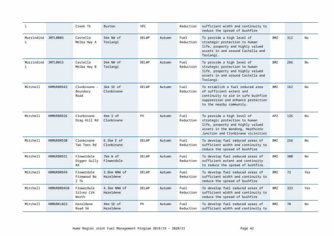
0017
Indigo HR-OVE-BEE-0031
Mt Pilot - Old Coach Road
6km E of Mt Pilot PV Autumn Fuel Reduction
To develop fuel reduced areas of sufficient width and continuity to reduce the spread of bushfire through the National Park. Also providing protection for the Pilot Reference Area.
BMZ 250 No
Alpine HR-OVE-MYT-0006
Myrtleford - 9 Mile Tk
11km SE off Myrtleford PV Autumn Fuel Reduction
To develop fuel reduced areas of sufficient width and continuity to reduce the spread of bushfire and threat to assets and property.
BMZ 978 No
Alpine HR-OVE-MYT-0018
Myrtleford - Back Creek Road
5km S of Myrtleford PV Autumn Fuel Reduction
To develop fuel reduced areas of sufficient width and continuity to reduce the spread and intensity of bushfires.
BMZ 439 Yes
Indigo HR-OVE-BEE-0029
Staghorn Flat - Mt Murramurrangbong Northwest Slopes
20km SSE of Wodonga DELWP Autumn Fuel Reduction
To develop fuel reduced areas of sufficient width and continuity to reduce the spread of bushfire
BMZ 441 No
Indigo HR-OVE-BEE-0056
Stanley - Wombat Track
6km SW of Yackandandah
DELWP Autumn Fuel Reduction
To develop fuel reduced areas of sufficient width and continuity to reduce the spread and intensity of bushfire.
BMZ 61.9 No
Alpine HR-OVE-MBY-0009
Tawonga - German Creek
7km NW of Mount Beauty DELWP Autumn Fuel Reduction
To develop fuel reduced areas of sufficient width and continuity to reduce the spread of bushfire and threat to assets and property
LMZ 818 No
Alpine HR-OVE-BRT-0012
Wandiligong - Morses Creek
1km S of Wandiligong DELWP Autumn Fuel Reduction
To develop fuel reduced areas of sufficient width and continuity to reduce the speed and intensity of bushfires south of Wandiligong township.
BMZ 1815 No
Wangaratta Rural City
HR-OVE-WHT-0011
Whitfield - Whitlands State Forest
5km SW of Whitfield DELWP Autumn Fuel Reduction
To develop fuel reduced areas of sufficient width and continuity to reduce the spread of bushfire
LMZ 1351 No
Indigo HR-OVE-BEE-0039
Yackandandah - Hodgson Lane
5km North of Yackandandah
PV Autumn Fuel Reduction
To develop fuel reduced areas of sufficient width and continuity to reduce the spread of bushfire.
BMZ 659 No
Indigo HR-OVE-BEE-0043
Yackandandah - Marcus Creek
2km N of Yackandandah PV Autumn Fuel Reduction
To provide a highest level of localised protection to human life, property and community assets identified as highly valued including the Yackandandah township
APZ 166 Yes
Hume Region Joint Fuel Management Program 2018/19 – 2020/21 Page 42

DELWP Lead Agency Planned Burns 2020/21
Local Governmen
t Area
BurnNumber
Burn Name GeneralLocation
Land Manager
BurnSeason
Burn Type(FRB/ECO)
Land Management Objective FMZ Planned Burn Size
(ha)
New Burn?
Indigo HR-OVE-BEE-0007
Beechworth - Kerferd Track
4km E of Beechworth PV Autumn Fuel Reduction
To develop fuel reduced areas of sufficient width and continuity to reduce the spread of bushfire
LMZ 54.8 No
Wangaratta Rural City
HR-OVE-BEE-0014
Beechworth - Native Dog Peak
8km NW of Beechworth PV Autumn Fuel Reduction
To provide an irregular mosaic of areas of fuel reduction which will complement works in adjacent fuel management zones and to create a mosaic burn coverage appropriate to meet requirements of Grassy Dry Forest EVC
LMZ 920 No
Alpine HR-OVE-MBY-0014
Bogong - Lake Guy
1km N of Bogong PV Autumn Fuel Reduction
To develop fuel reduced areas of sufficient width and continuity to reduce the size and speed of bushfires.
LMZ 110 No
Indigo HR-OVE-BEE-0046
Bruarong - Bruarong Spur Track
6km E of Stanley DELWP Autumn Fuel Reduction
To provide bushfire protection by reducing overall fuel hazard and bushfire hazard in the landscape.
LMZ 287 No
Wangaratta Rural City
HR-OVE-MYT-0019
Carboor - Carboor Range North
5.5km NW of Carboor DELWP Autumn Fuel Reduction
To provide bushfire protection by reducing overall fuel hazard and bushfire hazard in the landscape.
LMZ 345 No
Wangaratta Rural City
HR-OVE-BEE-0042
Eldorado - Old Coach Road
1km N of Eldorado PV Autumn Fuel Reduction
To provide bushfire protection by reducing overall fuel hazard and bushfire hazard in the landscape.
LMZ 410 No
East Gippsland
HR-OVE-MBY-0003
Glen Valley - Dead Horse Creek
25km NW of Omeo PV Autumn Fuel Reduction
To develop a fuel reduced corridor to the west and north west of Glen Valley
LMZ 3161 No
Alpine HR-OVE-MBY-0010
Mount Beauty - Mount Emu
6.5km NE of Mt Beauty DELWP Autumn Fuel Reduction
To develop fuel reduced areas of sufficient width and continuity to reduce the spread of bushfire.
BMZ 2756 No
Alpine HR-OVE-MBY-0002
Mt Beauty - Woollybutt Spur Track
3km S of Mount Beauty PV Autumn Fuel Reduction
To provide bushfire mitigation for Bogong Village. LMZ 875 No
Indigo HR-OVE-BEE-
Mt Stanley - Granite Creek
5km SE of Stanley PV Autumn Fuel Reduction
To develop a fuel reduced area to the east of Mt Stanley tower and associated infrastructure.
BMZ 362 No
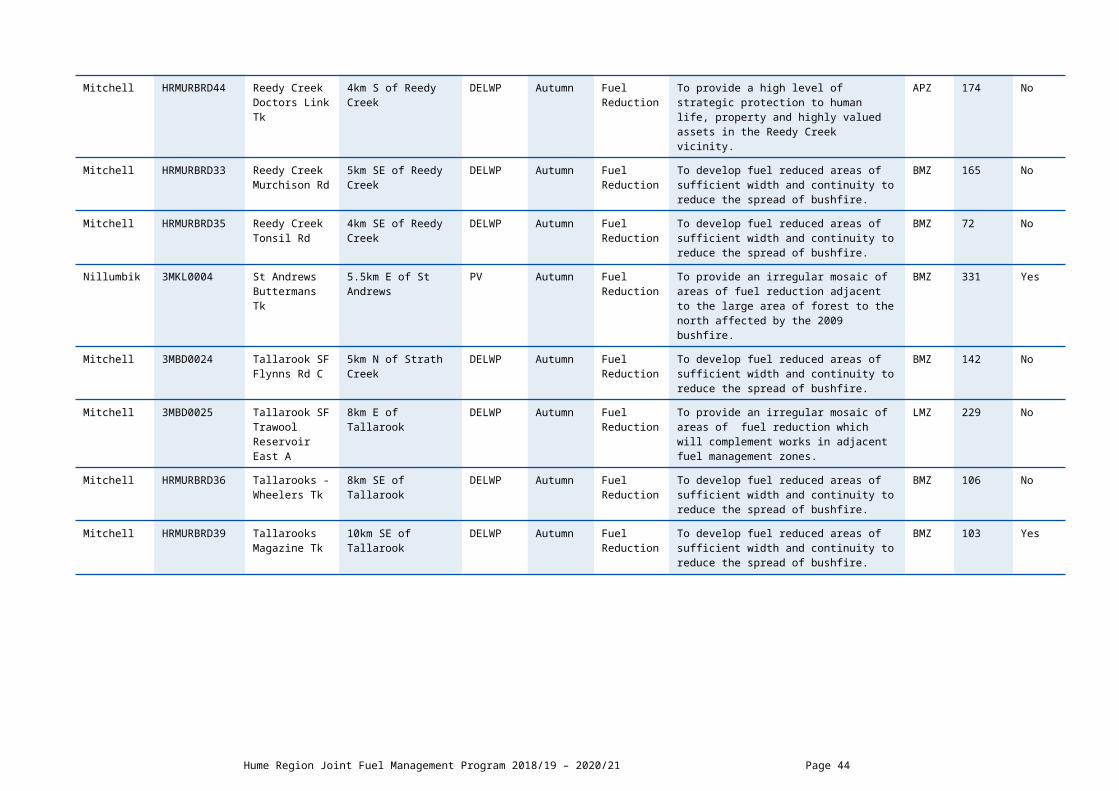
0052 Road
Alpine HR-OVE-MYT-0017
Ovens - McCormack Track
9km SE of Myrtleford DELWP Autumn Fuel Reduction
To develop fuel reduced areas of sufficient width and continuity to reduce the speed and intensity of bushfires.
BMZ 921 Yes
Alpine HR-OVE-BRT-0009
Porepunkah - McConnells Lane
2.5km NE of Porepunkah DELWP Autumn Fuel Reduction
To develop fuel reduced areas of sufficient width and continuity to reduce the spread of bushfire.
BMZ 1541 No
Indigo HR-OVE-MYT-0012
Stanley - Cue Springs Rd
5km S of Stanley DELWP Autumn Fuel Reduction
To develop fuel reduced areas of sufficient width and continuity to reduce the spread of bushfire and asset protection.
LMZ 59.2 No
Wangaratta Rural City
HR-OVE-WHT-0008
Tolmie - Upper 15 Mile Creek Tk
15km SW of Whitfield DELWP Autumn Fuel Reduction
To provide an irregular mosaic of areas of fuel reduction which will complement works in adjacent fuel management zones.
LMZ 986 No
Wangaratta Rural City
HR-OVE-WHT-0013
Whitlands - Burders Lane
11km SW of Whitfield DELWP Autumn Fuel Reduction
To provide an irregular mosaic of areas of fuel reduction which will complement works in adjacent fuel management zones.
LMZ 292 No
Wangaratta Rural City
HR-OVE-WHT-0014
Whitlands - Transmission Line Track
14km SW of Whitfield DELWP Autumn Fuel Reduction
To provide an irregular mosaic of areas of fuel reduction which will complement works in adjacent fuel management zones.
LMZ 624 No
Indigo HR-OVE-BEE-0037
Yackandandah - Rocky Point
8km SW of Yackandandah
PV Autumn Fuel Reduction
To provide an irregular mosaic of areas of fuel reduction which will complement works in adjacent fuel management zones
BMZ 139 No
Indigo HR-OVE-BEE-0055
Yackandandah - Service Basin Road
5km SW of Yackandandah
DELWP Autumn Fuel Reduction
To develop fuel reduced areas of sufficient width and continuity to reduce the spread and intensity of bushfire.
BMZ 188 No
Hume Region Joint Fuel Management Program 2018/19 – 2020/21 Page 44

SCHEDULE 2: NON-BURN FUEL TREATMENTS 2018/19 - DELWP Lead Agency The table below contains a summary of proposed non-burn fuel treatments over the following year. Some of these fuel treatments are annual, with others prioritised based on the seasonal conditions and which planned burns are scheduled. Accompanying maps provide detail on where these fuel treatment activities are located. Note that the maps show approximate areas only and the actual treatment area will be dependent on the condition of the fuels at the time of assessment. Please contact your local DELWP or Parks Victoria office if further detail is required.
Works by Land ManagerParks Victoria (ha)
DELWP(ha)
Other(ha)
Hectares Planned 179 345 22
SCHEDULE 3: NEW STRATEGIC FUELBREAKS 2018/19 - DELWP Lead Agency DELWP and Parks Victoria work together to establish and maintain a network of strategic fuelbreaks to expand the protection of communities, forests and parks from the risk of bushfire. A strategic fuelbreak is a strip of land where vegetation has been modified to reduce the amount of fuel available to burn during a bushfire. Strategic fuelbreaks are an important tool for fire management on public land. They provide a fuel-reduced area from which to conduct back burning ahead of an approaching bushfire or to assist in the implementation of a planned burn.
Machinery is used to clear vegetation generally within a 15-20-metre-wide strip. In some instances, this width could be up to 40m. Existing roads and tracks are considered part of the clearing. Where possible, overstorey trees are retained to provide shading and connection between the trees for wildlife and landscape values. The locations of strategic fuelbreaks are included for information only. These activities are approved via other DELWP and Parks Victoria processes. CFA strategic fuel breaks are included in Municipal Fire Management Plans.
Strategic fuel break maintenance is an annual program and included in Schedule 2 above.
There are no strategic fuel breaks scheduled for construction.

DELWP LEAD AGENCY UPPER MURRAY DISTRICT SCHEDULESCHEDULE 1: PLANNED BURNS The activities in this schedule are planned burns.
Please note that the planned burn year and season identified for each planned burn is indicative only and may be changed due to weather conditions and operational requirements.
Abbreviations in Schedule1: ‘*’ asterisk on burn name denotes a cross tenure burn; PV - Parks Victoria; COM - Committee of Management; DELWP- Department of Environment Land Water and Planning; PP – Private Property; FRB - Fuel Reduction Burn; ECO - ecological burn; FMZ – Fire Management Zone; APZ - Asset Protection Zone; BMZ – Bushfire Moderation Zone; LMZ - Landscape Management Zone; PBEZ – Planned Burn Exclusion Zone; NZ -Not Zoned.
DELWP Lead Agency Planned Burns 2018/19
Local Governmen
t Area
BurnNumber
Burn Name GeneralLocation
Land Manager
BurnSeason
Burn Type(FRB/ECO)
Land Management Objective FMZ Planned Burn Size
(ha)
New Burn?
Towong UPMTAL06 Bethanga - Mitchells Tk
6.5km W of Bethanga PV Autumn Fuel Reduction
To develop fuel reduced areas of sufficient width and continuity to reduce the speed and intensity of bushfires.
BMZ 92 No
Towong 3UCOR028 Biggara - Barlows Break
15km S of Biggara PV Autumn Fuel Reduction
To develop fuel reduced areas of sufficient width and continuity to reduce the speed and intensity of bushfires.
BMZ 2580 No
Wodonga City
3UTAL077 Bonegilla - Bonegilla Grasslands
1km W of Bonegilla PV Winter Ecological To encourage the establishment of native grasses.
LMZ 11 No
Towong 3UCOR043 Bunroy- Mt Unicorn
19km SE of Corryong DELWP Autumn Fuel Reduction
To develop a fuel reduced area to the north of Dart Mining infrastructure.
BMZ 1564 No
Towong 3UCOR045 Burrowa Pine Mtn NP - Lookouts Walking Tk
7km W of Cudgewa North t
PV Autumn Fuel Reduction
To develop fuel reduced areas of sufficient width and continuity to reduce the spread of bushfire.
LMZ 219 No
Towong UPMTAL01 Burrowye - Napoleon Ridge Tk
4.5km SSW of Burrowye
DELWP Autumn Fuel Reduction
To develop a fuel reduced area to the north and west of the pine plantation.
NZ 262 No
Towong 3UTAL084 Burrowye - Versos Fireline
6.5km SW of Burrowye DELWP Autumn Fuel Reduction
To provide the highest level of localised protection to human life, property and
APZ 65 No
Hume Region Joint Fuel Management Program 2018/19 – 2020/21 Page 46
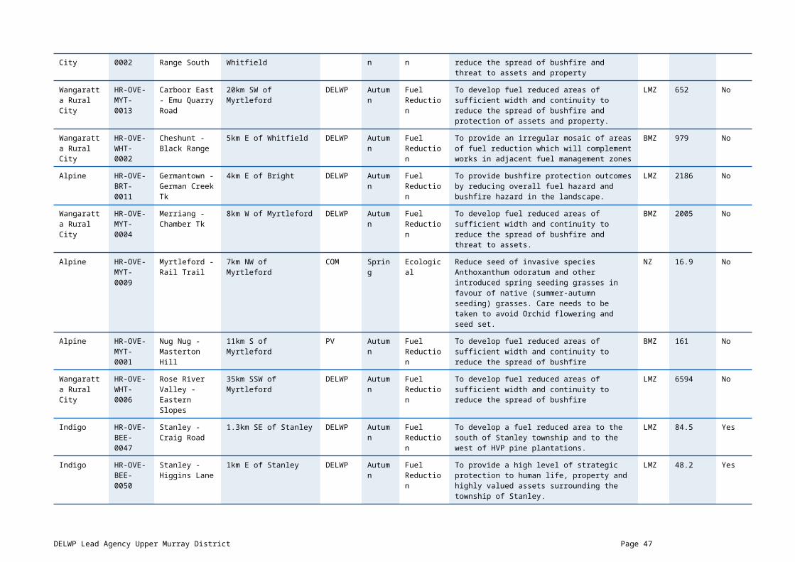
community assets identified as highly valued including pine plantations.
Towong 3UCOR058 Cudgewa - Cudgewa Railway
Within the township of Cudgewa
DELWP Spring Fuel Reduction
To provide the highest level of localised protection to human life, property and community assets identified as highly valued including Cudgewa township.
APZ 4.4 No
Towong 3UCOR034 Cudgewa - Ranch Road
7km NE of Cudgewa PV Autumn Fuel Reduction
To provide bushfire protection outcomes by reducing overall fuel hazard and bushfire hazard in the landscape.
LMZ 211 No
Towong 3UCOR075 Dartmouth - Raymond Crk
15km E of Dartmouth Township
DELWP Autumn Fuel Reduction
To provide bushfire protection outcomes by reducing overall fuel hazard and bushfire hazard in the landscape.
LMZ 977 No
Towong UPMMIT01 Eskdale - Smythes Rd
1km SW of Eskdale DELWP Autumn Fuel Reduction
To provide bushfire protection outcomes by reducing overall fuel hazard and bushfire hazard in the landscape.
LMZ 2780 No
Towong 3UTAL062 Fernvale - Mailmans Gap
7km S of Tallangatta DELWP Autumn Fuel Reduction
To provide bushfire protection outcomes by reducing overall fuel hazard and bushfire hazard in the landscape.
LMZ 716 No
Towong 3UTA015 Georges Creek Hillas Tk
8km NNE of Tallangatta PV Autumn Fuel Reduction
To provide bushfire protection outcomes by reducing overall fuel hazard and bushfire hazard in the landscape.
LMZ 239 No
Towong 3UMIT066 Granite Flat - Holloway Log Dump
8.5km SE of Mitta Mitta DELWP Autumn Fuel Reduction
To burn the planned area during autumn and reduce grass biomass fire hazard.
NZ 2.4 Yes
Towong 3UTAL051 Granya - Firebrace Link Track
2km SE of Granya DELWP Autumn Fuel Reduction
To develop fuel reduced areas of sufficient width and continuity to reduce the speed and intensity of bushfires.
BMZ 361 No
Towong 3UTAL063 Granya - Hanleys 2km W of Granya PV Autumn Fuel Reduction
To develop fuel reduced areas of sufficient width and continuity to reduce the speed and intensity of bushfires.
BMZ 719 No
Towong 3UCOR097 Lucyvale - Beetoomba Spur Tk
5.5km SW of Lucyvale DELWP Autumn Fuel Reduction
To develop a fuel reduced area to the north of the Wabba Wilderness Park.
BMZ 549 No
Towong 3UCOR030 Lucyvale - Gibb Range
9km S of Lucyvale Settlement
DELWP Autumn Fuel Reduction
To develop fuel reduced areas of sufficient width and continuity to reduce the speed and intensity of bushfires.
BMZ 1258 No
DELWP Lead Agency Upper Murray District Page 47

Towong UPMMIT04 Mitta Mitta - Bullhead Gap Rd
3km N of Mitta Mitta DELWP Autumn Fuel Reduction
To develop fuel reduced areas of sufficient width and continuity to reduce the speed and intensity of bushfires.
BMZ 1143 No
Alpine 3UTAL007 Mongans Bridge - Mullagong Bushland Reserve
10km N of Tawonga PV Autumn Fuel Reduction
To provide a high level of strategic protection to human life, property and highly valued assets (Orchard)
LMZ 26 No
Towong UPMCOR03 Nariel Valley - Dart River
6km WSW of Nariel Settlement
DELWP Autumn Fuel Reduction
To develop a fuel reduced area to the south-east of the Wabba Wilderness Park.
BMZ 1041 No
Towong 3UCOR038 Nariel Valley - Rawes Creek
14km N of Nariel Valley Settlement
DELWP Autumn Fuel Reduction
To develop fuel reduced areas of sufficient width and continuity to reduce the speed and intensity of bushfires.
BMZ 1161 No
Towong 3UMM005 Tallandoon Lockharts Gap Rd
4.5km N of Eskdale DELWP Autumn Fuel Reduction
To provide bushfire protection outcomes by reducing overall fuel hazard and bushfire hazard in the landscape.
LMZ 3324 No
Towong 3UTAL057 Tallangatta Valley - Little Bucheen Creek
7km NE of Bucheen Creek
DELWP Autumn Fuel Reduction
To provide bushfire protection outcomes by reducing overall fuel hazard and bushfire hazard in the landscape.
LMZ 3009 No
Towong 3UTAL056 Tallangatta Valley - Mt Cudgewa
9km SE of Tallangatta Valley fire shed
DELWP Autumn Fuel Reduction
To provide bushfire protection outcomes by reducing overall fuel hazard and bushfire hazard in the landscape.
LMZ 1091 No
Towong 3UTAL053 Thologolong - Kurrajong Trk
16km NW of Burrowye within Mt Lawson State Park
PV Spring Fuel Reduction
To develop a fuel reduced corridor north of the Mt Lawson State Park, reduce overall biomass and reduce exotic grass species. (same as BONEGILLA GRASSLAND - target different sections every year)
LMZ 51 No
Towong 3UCOR103 Tom Groggin - Stoney Crk Tk
1km W of Tom Groggin Station
PV Autumn Fuel Reduction
To develop a fuel reduced area to the west of Tom Groggin Station.
APZ 1410 No
Hume Region Joint Fuel Management Program 2018/19 – 2020/21 Page 48

DELWP Lead Agency Planned Burns 2019/20
Local Government
Area
BurnNumber
Burn Name GeneralLocation
Land Manager
BurnSeason
Burn Type(FRB/ECO)
Land Management Objective FMZ Planned Burn Size
(ha)
New Burn?
Towong 3UCOR108 Berringama - Bush Rat Track
5.5km NW of Cudgewa PV Autumn Fuel Reduction
To provide bushfire protection outcomes by reducing overall fuel hazard and bushfire hazard in the landscape.
LMZ 1190 No
Towong 3UCOR074 Biggara - Charlie Crk
10km SE of Corryong DELWP Autumn Fuel Reduction
To provide bushfire protection outcomes by reducing overall fuel hazard and bushfire hazard in the landscape.
LMZ 343 No
Towong 3UTAL087 Bullioh - Tallangatta Creek SSR
12.5km E of Tallangatta PV Autumn Fuel Reduction
To develop fuel reduced areas of sufficient width and continuity to reduce the spread of bushfire.
LMZ 6.8 Yes
Towong 3UTAL038 Burrowye - Chicks Track
4km S of Burrowye DELWP Autumn Fuel Reduction
To develop fuel reduced areas of sufficient width and continuity to reduce the speed and intensity of bushfires.
NZ 161 No
Towong 3UCOR085 Dartmouth - Brown Crk
20km E of Dartmouth Township
PV Autumn Fuel Reduction
To develop fuel reduced areas of sufficient width and continuity to reduce the speed and intensity of bushfires.
BMZ 849 No
East Gippsland
3UMIT052 Dartmouth - JP Gap Tk
20km N of Benambra PV Autumn Fuel Reduction
To develop fuel reduced areas of sufficient width and continuity to reduce the speed and intensity of bushfires.
BMZ 1061 No
Towong UPMCOR06 Dartmouth - Murtaghs Creek East
15km E of Dartmouth township
PV Autumn Fuel Reduction
To provide bushfire protection outcomes by reducing overall fuel hazard and bushfire hazard in the landscape.
LMZ 1842 No
Towong 3UMIT045 Dartmouth - Walshs Road
200m SW of Dartmouth Township
DELWP Autumn Fuel Reduction
To provide the highest level of localised protection to human life, property and community assets identified as highly valued including Dartmouth township.
APZ 324 No
Towong 3UMIT060 Eskdale - Lords Cutting
7.7km E of Eskdale DELWP Autumn Fuel Reduction
To provide the highest level of localised protection to human life, property and community assets identified as highly valued including Mitta Mitta township and pine plantation.
APZ 171 No
Towong UPMTAL04 Georges Creek - 3km N of Georges PV Autumn Fuel To provide bushfire protection outcomes by LMZ 339 No
DELWP Lead Agency Upper Murray District Page 49

Mt Granya Walking Tk
Creek Reduction reducing overall fuel hazard and bushfire hazard in the landscape.
Towong UPMTAL02 Granya - Bolga Fireline
5km ENE of Georges Creek
PV Autumn Fuel Reduction
To provide bushfire protection outcomes by reducing overall fuel hazard and bushfire hazard in the landscape.
LMZ 400 No
Towong 3UTAL061 Jarvis Crk - Plateau Rd
3km NW of Old Tallangatta
PV Autumn Fuel Reduction
To provide bushfire protection outcomes by reducing overall fuel hazard and bushfire hazard in the landscape.
LMZ 92 No
Towong 3UTAL086 Koetong - Grandmothers Track
6km NNW of Koetong DELWP Autumn Fuel Reduction
To develop fuel reduced areas of sufficient width and continuity to reduce the speed and intensity of bushfires.
APZ 217 Yes
Towong 3UTAL064 Koetong - Mt Brutal
5km SW of Koetong DELWP Autumn Fuel Reduction
To develop fuel reduced areas of sufficient width and continuity to reduce the speed and intensity of bushfires.
BMZ 839 No
Towong 3UCOR098 Lucyvale - Lucky Hit Creek
3km W of Lucyvale DELWP Autumn Fuel Reduction
To develop fuel reduced areas of sufficient width and continuity to reduce the speed and intensity of bushfires.
BMZ 2557 No
Towong 3UMIT024 Mitta Mitta - Magorra Range
5km E Mitta Mitta DELWP Autumn Fuel Reduction
To develop a fuel reduced area to the north and west of the Dartmouth township and Granite Flat.
BMZ 2942 No
Towong 3UTAL055 Mt Lawson SP - Mother Duff
11km NE of Granya PV Autumn Fuel Reduction
To develop fuel reduced areas of sufficient width and continuity to reduce the speed and intensity of bushfires.
BMZ 1893 No
Towong 3UCOR064 Nariel Valley - Graptolite Gully
4km W of Nariel Valley Community
PV Autumn Fuel Reduction
To provide bushfire protection outcomes by reducing overall fuel hazard and bushfire hazard in the landscape.
LMZ 3865 No
Towong 3UCOR067 Nariel Valley - Shady Creek
12km SE of Nariel Valley Community
DELWP Autumn Fuel Reduction
To provide an irregular mosaic of areas of fuel reduction which will complement works in adjacent fuel management zones
LMZ 650 No
Towong 3UCOR080 Nariel Valley - Wabba Crk
17km SW of Corryong PV Autumn Fuel Reduction
To provide bushfire protection outcomes by reducing overall fuel hazard and bushfire hazard in the landscape.
LMZ 776 No
Towong 3UTAL030 Tallangatta - Kendells Fireline
6km SSE of Tallangatta DELWP Autumn Fuel Reduction
To provide bushfire protection outcomes by reducing overall fuel hazard and bushfire hazard in the landscape.
LMZ 492 No
Hume Region Joint Fuel Management Program 2018/19 – 2020/21 Page 50
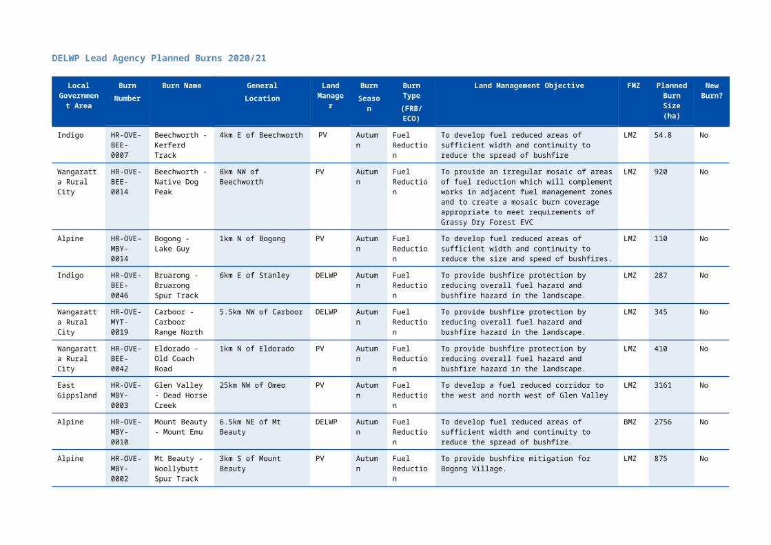
Towong 3UTAL034 Tallangatta Valley - Matthews Creek Tk
7km SE of Tallangatta Valley
DELWP Autumn Fuel Reduction
To develop fuel reduced areas of sufficient width and continuity to reduce the speed and intensity of bushfires.
BMZ 627 No
Towong 3UCOR089 Towong - Kiells Tk 6km N of Corryong PV Autumn Fuel Reduction
To provide bushfire protection outcomes by reducing overall fuel hazard and bushfire hazard in the landscape.
LMZ 711 No
Alpine 3UTAL029 Upper Gundowring - Mullagong Fireline
8km SE of Dederang DELWP Autumn Fuel Reduction
To develop fuel reduced areas of sufficient width and continuity to reduce the speed and intensity of bushfires.
BMZ 1933 No
DELWP Lead Agency Upper Murray District Page 51

DELWP Lead Agency Planned Burns 2020/21
Local Governmen
t Area
BurnNumber
Burn Name GeneralLocation
Land Manager
BurnSeason
Burn Type(FRB/ECO)
Land Management Objective FMZ Planned Burn Size
(ha)
New Burn?
Towong 3UCOR105 Biggara - Mt Morgan
21km S of Corryong DELWP Autumn Fuel Reduction
To develop fuel reduced areas of sufficient width and continuity to reduce the speed and intensity of bushfires.
BMZ 1369 Yes
Towong 3UTAL088 Bucheen Creek - Tallangatta Creek Track
17km NE Of Mitta Mitta Township
DELWP Autumn Fuel Reduction
To develop fuel reduced areas of sufficient width and continuity to reduce the speed and intensity of bushfires.
BMZ 1483 Yes
Towong UPMCOR08 Burrowa Pine Mtn NP - Hinces Creek Walking Tk
9.2km NW of Cudgewa PV Autumn Fuel Reduction
To provide bushfire protection outcomes by reducing overall fuel hazard and bushfire hazard in the landscape.
LMZ 1374 No
Towong 3UTAL076 Burrowye - East West Rd
11km NE of Koetong DELWP Autumn Fuel Reduction
To develop a fuel reduced area to the west of the pine plantation.
BMZ 201 No
Towong 3UMIT069 Dartmouth - Coleman Creek Track
5km NNW Of Dartmouth Township
DELWP Autumn Fuel Reduction
To develop fuel reduced areas of sufficient width and continuity to reduce the speed and intensity of bushfires.
BMZ 932 Yes
Towong 3UCOR086 Dartmouth - Vincent Crk
15km E of Dartmouth Township
PV Autumn Fuel Reduction
To provide bushfire protection outcomes by reducing overall fuel hazard and bushfire hazard in the landscape.
LMZ 860 No
East Gippsland
3UMIT047 Glen Valley - One Mile Spur Tk
16km NW of Benambra PV Autumn Fuel Reduction
To provide bushfire protection outcomes by reducing overall fuel hazard and bushfire hazard in the landscape.
LMZ 1193 No
Towong 3UMIT025 Granite Flat - West Branch
10km S of Mitta Mitta DELWP Autumn Fuel Reduction
To develop a fuel reduced area to the west of the Granite Flat.
BMZ 3211 No
Towong 3UTAL093 Koetong - Edgars & Brophys
6km SSW of Koetong DELWP Autumn Fuel Reduction
To develop fuel reduced areas of sufficient width and continuity to reduce the spread of bushfires.
BMZ 175 Yes
Towong 3UTAL092 Koetong - No Name Track
4.5km NW of Koetong DELWP Autumn Fuel Reduction
To develop fuel reduced areas of sufficient width and continuity to reduce the speed and intensity of bushfires.
APZ 265 Yes
Towong 3UCOR107 Lucyvale - Osbornes Creek
7km SW of Lucyvale DELWP Autumn Fuel Reduction
To develop fuel reduced areas of sufficient width and continuity to reduce the speed and intensity of
BMZ 2100 Yes
Hume Region Joint Fuel Management Program 2018/19 – 2020/21 Page 52

bushfires.
Towong 3UMIT064 Mitta Mitta - Disappointment Tk
2km SE of Mitta Mitta DELWP Autumn Fuel Reduction
To provide the highest level of localised protection to human life, property and community assets identified as highly valued including Mitta Mitta township.
APZ 236 No
Towong 3UMIT070 Mitta Mitta - Mitta Mitta Reference Area
8km N of Mitta Mitta DELWP Autumn Fuel Reduction
To provide bushfire protection outcomes by reducing overall fuel hazard and bushfire hazard in the landscape.
LMZ 1183 No
Towong 3UMIT065 Mitta Mitta - Mt Welcome Hike
1km S of Mitta Mitta DELWP Autumn Fuel Reduction
To provide the highest level of localised protection to human life, property and community assets identified as highly valued including Mitta Mitta township.
APZ 381 No
Towong 3UMIT067 Mitta North - Tallandoon Track
5km NE of Eskdale DELWP Autumn Fuel Reduction
To develop fuel reduced areas of sufficient width and continuity to reduce the speed and intensity of bushfires.
LMZ 889 Yes
Towong 3UTAL095 Shelley - Mountain Creek Education Area
3km NE of Shelley PV Winter Ecological To create a mosaic burn coverage appropriate to meet requirements of native grasses and disadvantage exotics. To modify the vegetation composition across the planned area to assist the promotion of native grasses.
BMZ 12 No
Towong 3UTAL094 Shelley - Red Track West
5.5km N of Shelley DELWP Autumn Fuel Reduction
To develop fuel reduced areas of sufficient width and continuity to reduce the spread of bushfires.
BMZ 154.5 Yes
Towong 3UMIT068 Tallandoon - Yabba Link Track
6km NE of Eskdale DELWP Autumn Fuel Reduction
To develop fuel reduced areas of sufficient width and continuity to reduce the speed and intensity of bushfires.
BMZ 217 Yes
Towong 3UTAL090 Tallangatta Valley - Doghouse Gully
20km ESE of Tallangatta DELWP Autumn Fuel Reduction
To develop fuel reduced areas of sufficient width and continuity to reduce the speed and intensity of bushfires.
BMZ 713 Yes
Towong 3UTAL091 Tallangatta Valley - King Creek
16km SE of Tallangatta Valley Settlement
DELWP Autumn Fuel Reduction
To develop fuel reduced areas of sufficient width and continuity to reduce the speed and intensity of bushfires.
LMZ 2030 Yes
Towong 3UTAL032 Tallangatta Valley - Little Razorback
10km SSE of Tallangatta Valley Township
DELWP Autumn Fuel Reduction
To develop fuel reduced areas of sufficient width and continuity to reduce the speed and intensity of bushfires.
BMZ 2550 No
Towong 3UCOR106 Thowgla Valley - Kangaroo Creek
12km SSE of Corryong DELWP Autumn Fuel Reduction
To develop fuel reduced areas of sufficient width and continuity to reduce the speed and intensity of
BMZ 920 Yes
DELWP Lead Agency Upper Murray District Page 53
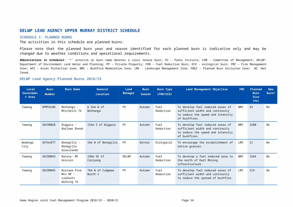
bushfires.
Towong 3UCOR087 Thowgla Valley - Mystery Lane
10km S of Corryong DELWP Autumn Fuel Reduction
To develop fuel reduced areas of sufficient width and continuity to reduce the speed and intensity of bushfires.
BMZ 792 No
Indigo 3UTAL089 Upper Sandy Creek - Williams Track
16km SSE of Tallangatta DELWP Autumn Fuel Reduction
To develop fuel reduced areas of sufficient width and continuity to reduce the speed and intensity of bushfires.
BMZ 826 Yes
Towong 3UCOR104 Walwa - Red Bank Creek
3.5km WNW of Walwa DELWP Autumn Fuel Reduction
To develop fuel reduced areas of sufficient width and continuity to reduce the speed and intensity of bushfires.
LMZ 236 Yes
Hume Region Joint Fuel Management Program 2018/19 – 2020/21 Page 54

SCHEDULE 2: NON-BURN FUEL TREATMENTS 2018/19 - DELWP Lead Agency The table below contains a summary of proposed non-burn fuel treatments over the following year. Some of these fuel treatments are annual, with others prioritised based on the seasonal conditions and which planned burns are scheduled. Accompanying maps provide detail on where these fuel treatment activities are located. Note that the maps show approximate areas only and the actual treatment area will be dependent on the condition of the fuels at the time of assessment. Please contact your local DELWP or Parks Victoria office if further detail is required.
Works by Land ManagerParks Victoria (ha)
DELWP(ha)
Other(ha)
Hectares Planned 97 1122 119
SCHEDULE 3: NEW STRATEGIC FUELBREAKS 2018/19 - DELWP Lead Agency DELWP and Parks Victoria work together to establish and maintain a network of strategic fuelbreaks to expand the protection of communities, forests and parks from the risk of bushfire. A strategic fuelbreak is a strip of land where vegetation has been modified to reduce the amount of fuel available to burn during a bushfire. Strategic fuelbreaks are an important tool for fire management on public land. They provide a fuel-reduced area from which to conduct back burning ahead of an approaching bushfire or to assist in the implementation of a planned burn.
Machinery is used to clear vegetation generally within a 15-20-metre-wide strip. In some instances, this width could be up to 40m. Existing roads and tracks are considered part of the clearing. Where possible, overstorey trees are retained to provide shading and connection between the trees for wildlife and landscape values. The locations of strategic fuelbreaks are included for information only. These activities are approved via other DELWP and Parks Victoria processes. CFA strategic fuel breaks are included in Municipal Fire Management Plans.
Strategic fuel break maintenance is an annual program and included in Schedule 2 above.
There are no strategic fuel breaks scheduled for construction.
DELWP Lead Agency Upper Murray District Page 55
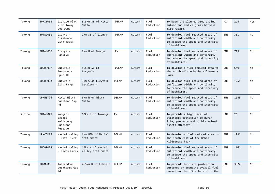
CFA LEAD AGENCY 12 DISTRICT SCHEDULESCHEDULE 1: PLANNED BURNS The activities in this schedule are planned burns.
Please note that the planned burn year and season identified for each planned burn is indicative only and may be changed due to weather conditions and operational requirements.
Abbreviations in Schedule1: ‘*’ asterisk on burn name denotes a cross tenure burn; COM - Committee of Management; PP – Private Property; FRB - Fuel Reduction Burn; ECO - ecological burn;
CFA Lead Agency Planned Burns 2018/19
CFA Lead Agency Planned Burns 2019/20
No planned burns scheduled.
CFA Lead Agency Planned Burns 2020/21
No planned burns scheduled.
Hume Region Joint Fuel Management Program 2018/19 – 2020/21 Page 56
Local Government Area
Burn Number
Burn Name GeneralLocation
Land Owner/Manager
BurnSeason
Burn Type(FRB/ECO)
Land Management Objective Planned Burn Size (ha)
Planned Burn Size (km)
Mitchell D12-18-004
Beveridge Rec. Reserve
Beveridge COM Autumn Fuel Reduction
To reduce overall biomass 0.7
Murrindindi D12-19-005
KIWE-2 Kinglake West
Watsons Rd Kinglake West
Autumn Fuel Reduction
Fuel reduction treatment of elevated, bark, near surface and surface fuels on roadside.
1
Mitchell D12-19-003
TOOB-1 Football Oval and Hall
Tooborac Football Ground Northern HWY Tooborac
Autumn Fuel Reduction
Fuel reduction of grass around football ground and NSP
1
Mitchell D12-18-017
White-1 Wine Shanty Lane
Wine Shanty Lane Whiteheads Creek
Spring Pine Slash To develop a fuel reduced corridor in old pine plantation using forestry Mulcher North of White Heads Creek Township
8

SCHEDULE 2: NON-BURN FUEL TREATMENTS 2018/19 - CFA Lead Agency The table below contains a summary of proposed non-burn fuel treatments over the following year. Some of these fuel treatments are annual, with others prioritised based on the seasonal conditions and which planned burns are scheduled. Accompanying maps provide detail on where these fuel treatment activities are located. Note that the maps show approximate areas only and the actual treatment area will be dependent on the condition of the fuels at the time of assessment. Please contact your local CFA office if further detail is required.
Works by TypeMulching (ha)
Slashing(ha)
Other(ha)
Hectares Planned 3.4 0 0
Hume Region Joint Fuel Management Program 2018/19 – 2020/21 Page 57

CFA LEAD AGENCY 13 DISTRICT SCHEDULESCHEDULE 1: PLANNED BURNS The activities in this schedule are planned burns.
Please note that the planned burn year and season identified for each planned burn is indicative only and may be changed due to weather conditions and operational requirements.
Abbreviations in Schedule1: ‘*’ asterisk on burn name denotes a cross tenure burn; COM - Committee of Management; PP – Private Property; FRB - Fuel Reduction Burn; ECO - ecological burn;
CFA Lead Agency Planned Burns 2018/19
Local Government Area
Burn Number
Burn Name GeneralLocation
Land Owner/Manager
BurnSeason
Burn Type(FRB/ECO)
Land Management Objective Planned Burn Size (ha)
Planned Burn Size (km)
Yarra Ranges
D13-19-001
Belgrave South - Birdsland 1
Birdsland Mount Morton road Belgrave South
Autumn Fuel Reduction
To build on protection works in adjacent asset protection zone and reduce risk to Belgrave South township
6.3
Yarra Ranges
D13-17-015
Kalorama - May Moon Reserve
1190-1196 Mt Dandenong Tourist road Kalorama
Autumn Fuel Reduction
To develop fuel reduced areas of sufficient width and continuity to reduce the spread of bushfire and reduce weeds
0.6
Knox City D13-13-035
Knoxfield Lakewood
LAKEWOOD RESERVE, KNOXFIELD
Autumn Fuel Reduction
To provide a high level of strategic protection to human life, property and highly valued assets particularly the adjacent residential area
0.6
Yarra Ranges
D13-19-003
Launching Place - Bellbird Ave Reserve
2030 Warburton Highway Launching Place
Autumn Fuel Reduction
To provide a high level of strategic protection to human life, property and highly valued assets and reduce fuel along access road
0.4
Yarra Ranges
D13-19-004
Launching Place - Wickhams Reserve
Wickhams Reserve Warburton Highway and Merrigum Lane Launching Place
Autumn Fuel Reduction
To provide a high level of strategic protection to human life, property and highly valued assets and increase biodiversity
0.5
Yarra Ranges
D13-19-009
Monbulk 265 Old Emerald
265 Old Emerald road Monbulk
Autumn Fuel Reduction
To develop fuel reduced areas of sufficient width and continuity to reduce the spread of bushfire and protect adjacent houses
0.5
Yarra Ranges
D13-15-005
Monbulk Mountain District
325 Macclesfield road Monbulk
Spring Fuel Reduction
To develop fuel reduced areas of sufficient width and continuity to reduce the spread of bushfire and provide protection to the school
1.5
Hume Region Joint Fuel Management Program 2018/19 – 2020/21 Page 58
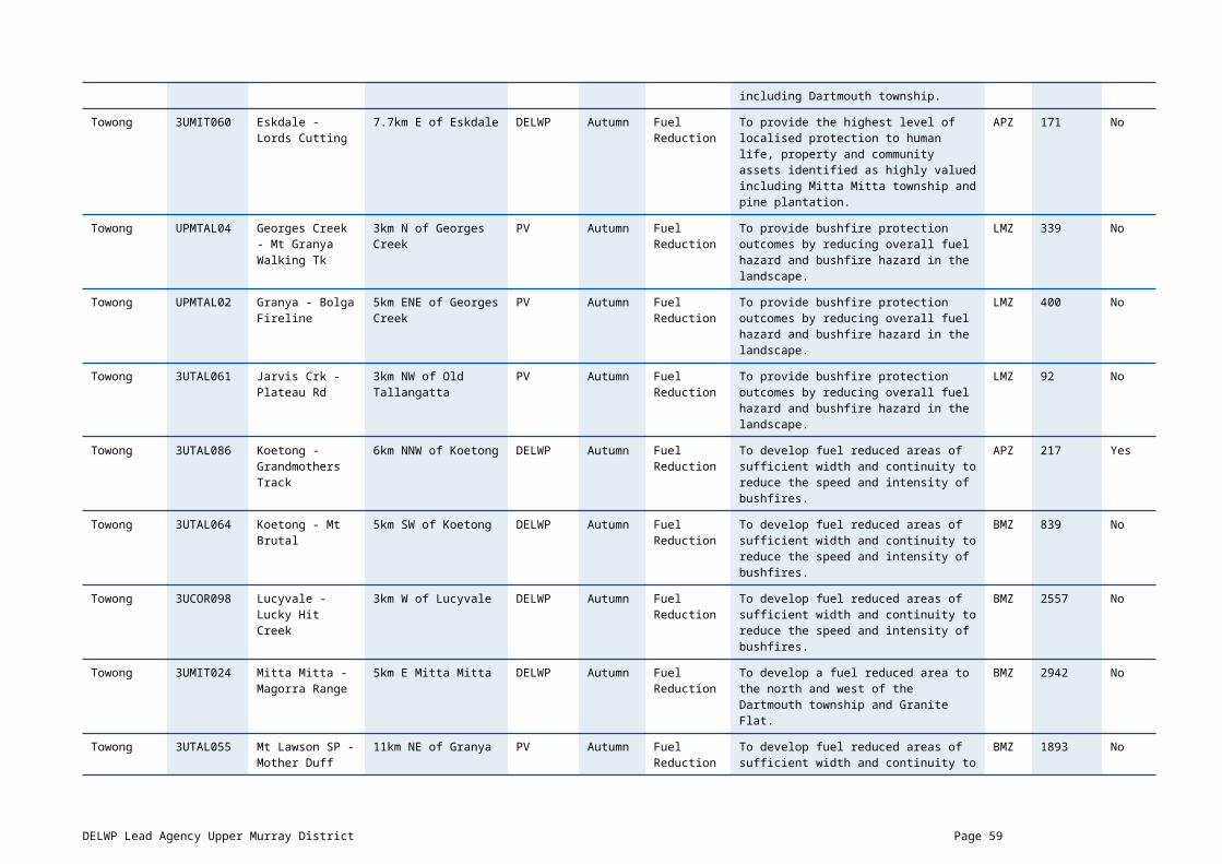
Christian School 5 & 6
Yarra Ranges
D13-15-015
Montrose Mt Evelyn Christian School
135-141 York road Montrose
Autumn Fuel Reduction
To provide a high level of strategic protection to human life, property and highly valued assets in particular the school buildings, staff and students and increase biodiversity
0.2
Knox City D13-10-030
Rowville Starlight
ROWVILLE Autumn Fuel Reduction
To provide a high level of strategic protection to human life, property and highly valued assets in the residential area adjoining the reserve
0.3
Yarra Ranges
D13-17-007
Selby Minak Reserve 1 & 2
Banool road Selby Autumn Fuel Reduction
To provide a high level of strategic protection to human life, property and highly valued assets <specify> and increase growth stage representation
0.4
Maroondah City
D13-18-011
The Basin - Bungalook
Kilsyth Maroondah City council
Autumn Ecological To provide conditions for the establishment of Kilsyth South Spider Orchid in densities at least greater than present
0.9
Knox City D13-13-045
Wantirna - Batemans
WANTIRNA Autumn Fuel Reduction
To provide a high level of strategic protection to human life, property and highly valued assets
1.1
Hume Region Joint Fuel Management Program 2018/19 – 2020/21 Page 59

CFA Lead Agency Planned Burns 2019/20
Local Government Area
Burn Number
Burn Name GeneralLocation
Land Owner/Manager
BurnSeason
Burn Type(FRB/ECO)
Land Management Objective Planned Burn Size (ha)
Planned Burn Size (km)
Yarra Ranges
Kalorama - Childs road
2 Childs road Kalorama Autumn Fuel Reduction
To develop fuel reduced areas of sufficient width and continuity to reduce the spread of bushfire and reduce radiant heat to anyone at the oval
0.5
CFA Lead Agency Planned Burns 2020/21
There are no planned burns scheduled.
SCHEDULE 2: NON-BURN FUEL TREATMENTS 2018/19 - CFA Lead Agency
There are no non-burn fuel treatments scheduled.
Hume Region Joint Fuel Management Program 2018/19 – 2020/21 Page 60
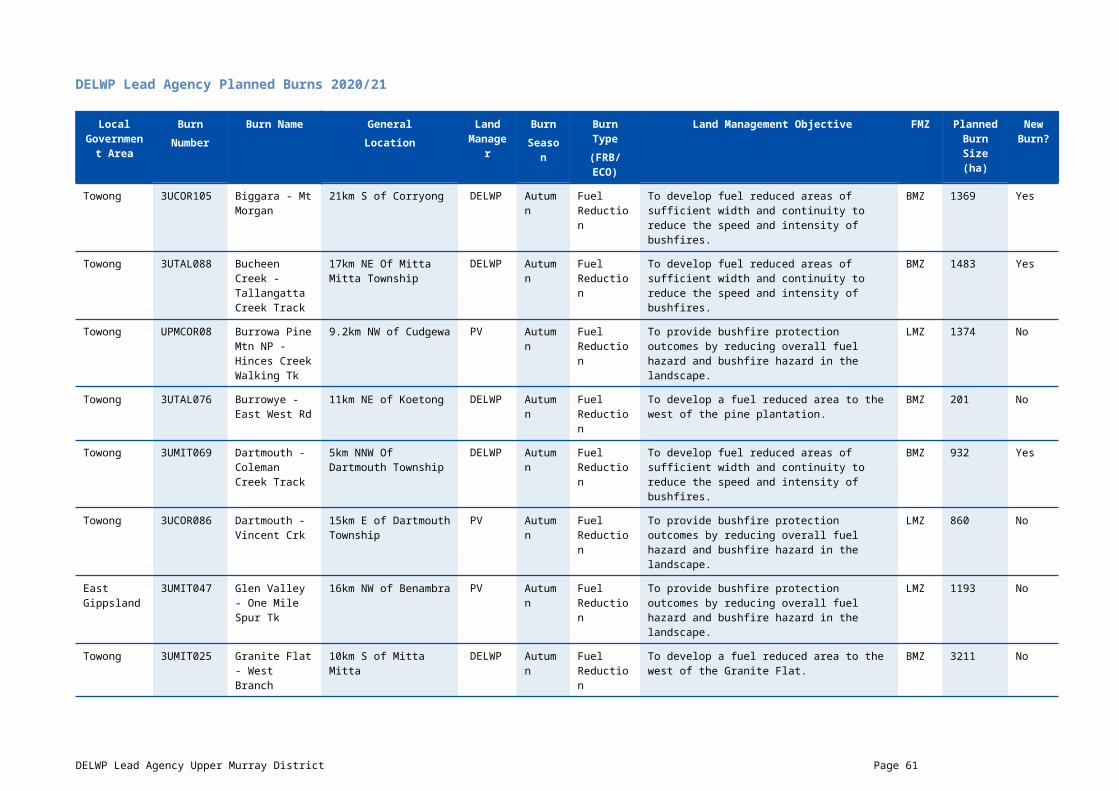
CFA LEAD AGENCY 22 DISTRICT SCHEDULESCHEDULE 1: PLANNED BURNS The activities in this schedule are planned burns.
Please note that the planned burn year and season identified for each planned burn is indicative only and may be changed due to weather conditions and operational requirements.
Abbreviations in Schedule1: ‘*’ asterisk on burn name denotes a cross tenure burn; COM - Committee of Management; PP – Private Property; FRB - Fuel Reduction Burn; ECO - ecological burn;
CFA Lead Agency Planned Burns 2018/19
Local Government Area
Burn Number
Burn Name GeneralLocation
Land Owner/Manager
BurnSeason
Burn Type(FRB/ECO)
Land Management Objective Planned Burn Size (ha)
Planned Burn Size (km)
Strathbogie D22-19-003
Locksley LLEY-1 Alexandersons Rd
Alexandersons Rd Locklsey
Autumn Fuel Reduction
Treatment of Phalaris infestations along sections of Alexandersons Rd.
1
Strathbogie D22-18-005
LOWD-1 Maxfield St West
Maxfield St West Longwood
Spring Fuel Reduction
Low intensity burn to reduce surface fuels. 0.05
Strathbogie D22-18-006
LOWD-3 Withers Street
Withers Street Longwood
Spring Fuel Reduction
Treat Withers Street (Longwood-Pranjip Road) on east side from last house north to township boundary edge of seal to fence. Complement 30 metre wide break inside private property.
1
Strathbogie D22-19-004
LOWD-4 Avenal Longwood Rd
Avenal Rd Longwood Spring Fuel Reduction
To reduce surface and near surface fuels 1
Strathbogie D22-18-004
LOWD-5 Puddy Lane
PUddy Lane Longwood Spring Fuel Reduction
treat Western Side of entire length of Puddy Lane from edge of formation to fence to compliment 30 metre wide brigade burnt break in abutting private property.
1
Strathbogie D22-18-007
LOWD-6-Correll Street
COrrell Street Longwood
Spring Fuel Reduction
Treat east side of Correll Street between Jean Street and Lyddy Street by removing near surface fuel.
1

Strathbogie D22-18-003
LOWD-7 Lyddy St
Lyddy Street Longwood Spring Fuel Reduction
Low intensity Burn to remove surface fuels. 1
Strathbogie D22-19-001
Marraweeny MARR-1 Boundary Hill
Boundary Hill Rd Kithbrook
Autumn Fuel Reduction
Fuel Reduction 1
Strathbogie D22-19-002
Miepoll MIEP-1 Clarkes Rd
Clarkes Rd Miepoll Autumn Fuel Reduction
Reduce overall fuel hazard on roadside. 1
Strathbogie D22-18-08
Viol-1 Murchison Violet Town Rd
Murchison Violet Town Rd Violet Town
Spring Fuel Reduction
Surface and Near Surface fuel reduction. 2
CFA Lead Agency Planned Burns 2019/20
No planned burns scheduled.
CFA Lead Agency Planned Burns 2020/21
There are no planned burns scheduled.
SCHEDULE 2: NON-BURN FUEL TREATMENTS 2018/19 - CFA Lead Agency
There are no non-burn fuel treatments scheduled.
Hume Region Joint Fuel Management Program 2018/19 – 2020/21 Page 62
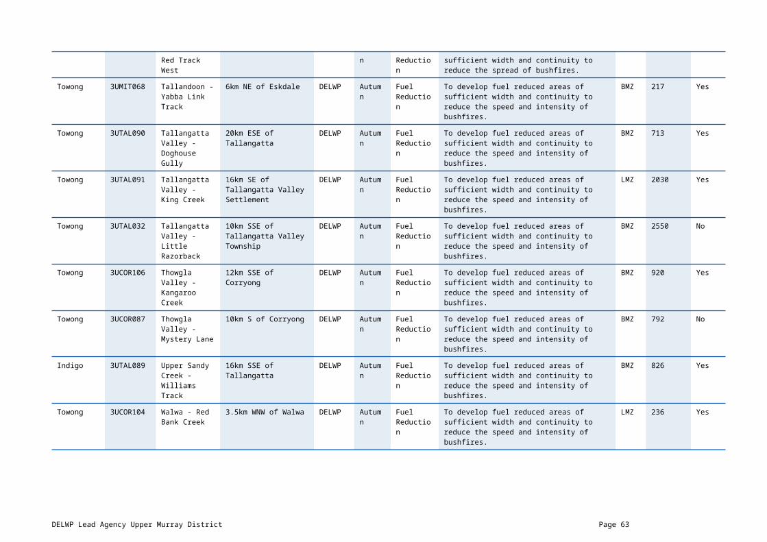
CFA LEAD AGENCY 23 DISTRICT SCHEDULESCHEDULE 1: PLANNED BURNS The activities in this schedule are planned burns.
Please note that the planned burn year and season identified for each planned burn is indicative only and may be changed due to weather conditions and operational requirements.
Abbreviations in Schedule1: ‘*’ asterisk on burn name denotes a cross tenure burn; COM - Committee of Management; PP – Private Property; FRB - Fuel Reduction Burn; ECO - ecological burn;
CFA Lead Agency Planned Burns 2018/19
Local Government Area
Burn Number
Burn Name GeneralLocation
Land Owner/Manager
BurnSeason
Burn Type(FRB/ECO)
Land Management Objective Planned Burn Size (ha)
Planned Burn Size (km)
Benalla Rural City
D23-18-015
Benalla Rail Reserve BENU-1
Benalla Spring Fuel Reduction To provide a high level of strategic protection to human life, property and highly valued assets within the town of Benalla.
32.8
Mansfield D23-18-080
BOON-5 Maroondah HWY
Maroondah HWY from Boonie Doon to Maindample
Autumn Fuel Reduction Selective treatment of Phalaris on roadside
5
Mansfield D23-18-011
MERT-1 Merton Euroa Rd
Merton Euroa Rd Merton
Autumn Fuel Reduction fuel reduction burn of South Side of Merton Euroa rd near NSP.
1
Mansfield D23-18-011
MERT-3 Merton Cemetery
Cemetery Walk & Maroondah HWY Merton
Autumn Fuel Reduction Selective fuel reduction of surface,near surface and elevated fuels along Cemetery walk.
1
Mansfield D23-18-011
MERT-5 Maroondah HWY
Maroondah HWY from Merton to Bonnie Doon
Autumn Fuel Reduction Selective treatment of Phalaris on roadside Maroondah Hwy from Merton to Bonnie Doon.
5
Mansfield D23-18-070
MPLE-10 Maroondah Hwy
Maroondah Hwy from Maindample to Mansfield
Autumn Fuel Reduction Selective treatment of Phalaris in roadside 5
Hume Region Joint Fuel Management Program 2018/19 – 2020/21 Page 63
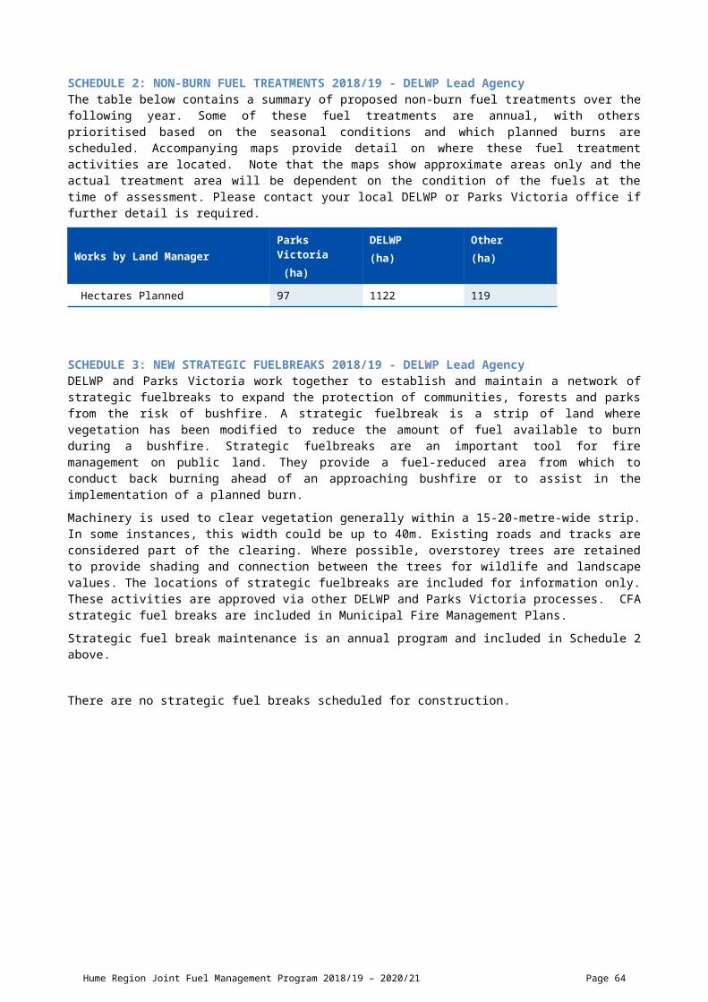
CFA Lead Agency Planned Burns 2019/20
Local Government Area
Burn Number
Burn Name GeneralLocation
Land Owner/Manager
BurnSeason
Burn Type(FRB/ECO)
Land Management Objective Planned Burn Size (ha)
Planned Burn Size (km)
Benalla Rural City
D23-19-015
Aerodrome BENU-2
Benalla Autumn Fuel Reduction To provide a high level of strategic protection to human life, property and highly valued assets.
25.3
Wangaratta Rural City
D23-19-007
Anzac Rd - SHRT-6
Springhurst Autumn Fuel Reduction To develop fuel reduced areas of sufficient width and continuity to reduce the spread of bushfire.
2
Wangaratta Rural City
D23-19-007
Anzac-Allison Roads - SHRT-1
Springhurst Autumn Fuel Reduction To develop fuel reduced areas of sufficient width and continuity to reduce the spread of bushfire.
4.7
Wangaratta Rural City
D23-19-038
Arnott-Yarrawonga Rd - KWRA-1
Killawarra Autumn Fuel Reduction To develop fuel reduced areas of sufficient width and continuity to reduce the spread of bushfire.
2.1
Wangaratta Rural City
D23-19-019
Beechworth-Wangaratta Road - EVER-9
Everton Autumn Fuel Reduction To develop fuel reduced areas of sufficient width and continuity to reduce the spread of bushfire.
24.5
Benalla Rural City
D23-19-012
Benalla Tatong Rd - TATO-1
Tatong Autumn Fuel Reduction To provide a high level of strategic protection to human life, property and highly valued assets.
0.3
Wangaratta Rural City
D23-19-019
Bennetts Lane - EVER-3
Everton Autumn Fuel Reduction To develop fuel reduced areas of sufficient width and continuity to reduce the spread of bushfire.
1.3
Benalla Rural City
D23-19-027
Bostock Road - MOLY-2
Molyullah Autumn Fuel Reduction To develop fuel reduced areas of sufficient width and continuity to reduce the spread of bushfire.
7.3
Wangaratta Rural City
D23-19-049
Bowmans Rd- BOWM-1
Bowmans Autumn Fuel Reduction To develop fuel reduced areas of sufficient width and continuity to reduce the spread of bushfire.
11.6
Hume Region Joint Fuel Management Program 2018/19 – 2020/21 Page 64

Wangaratta Rural City
D23-19-038
Brownings Road - KWRA-9
Killawarra Autumn Fuel Reduction To develop fuel reduced areas of sufficient width and continuity to reduce the spread of bushfire.
0.5
Wangaratta Rural City
D23-19-049
Buckland Gap Rd - BOWM-10
Murmungee Autumn Fuel Reduction To develop fuel reduced areas of sufficient width and continuity to reduce the spread of bushfire.
4.8
Wangaratta Rural City
D23-19-049
Buckland Gap Rd - BOWM-11
Murmungee Autumn Fuel Reduction To develop fuel reduced areas of sufficient width and continuity to reduce the spread of bushfire.
11.9
Wangaratta Rural City
D23-19-026
Carboor Everton Road - MILWA-1
Milawa Autumn Fuel Reduction To develop fuel reduced areas of sufficient width and continuity to reduce the spread of bushfire.
22.1
Wangaratta Rural City
D23-19-038
Chick Road - KWRA-7
Killawarra Autumn Fuel Reduction To develop fuel reduced areas of sufficient width and continuity to reduce the spread of bushfire.
3.2
Wangaratta Rural City
D23-19-007
Church Road - SHRT-9
Springhurst Autumn Fuel Reduction To develop fuel reduced areas of sufficient width and continuity to reduce the spread of bushfire.
2.4
Benalla Rural City
D23-19-018
Devenish - DEVE-1
Devenish Autumn Fuel Reduction To develop fuel reduced areas of sufficient width and continuity to reduce the spread of bushfire.
6.6
Wangaratta Rural City
D23-19-019
Dickens Rd - EVER-1
Everton Autumn Fuel Reduction To develop fuel reduced areas of sufficient width and continuity to reduce the spread of bushfire.
9
Wangaratta Rural City
D23-19-013
Egan Rd - GRWN-15
Glenrowan Autumn Fuel Reduction To develop fuel reduced areas of sufficient width and continuity to reduce the spread of bushfire.
41.5
Wangaratta Rural City
D23-19-013
Egan Rd - GRWN-9
Glenrowan Autumn Fuel Reduction To develop fuel reduced areas of sufficient width and continuity to reduce the spread of bushfire.
1
Wangaratta Rural City
D23-19-016
Federation Way - BOWS-1
Bowser Autumn Fuel Reduction To develop fuel reduced areas of sufficient width and continuity to reduce the spread of bushfire.
49.3
Hume Region Joint Fuel Management Program 2018/19 – 2020/21 Page 65

Wangaratta Rural City
D23-19-049
Ferguson Lane - BOWM-2
Murmungee Autumn Fuel Reduction To develop fuel reduced areas of sufficient width and continuity to reduce the spread of bushfire.
17.4
Wangaratta Rural City
D23-19-014
Finnen Road - BMAN-5
Boorhaman Autumn Fuel Reduction To develop fuel reduced areas of sufficient width and continuity to reduce the spread of bushfire.
17.2
Wangaratta Rural City
D23-19-031
Glenrowan Rd - SRAT-4
South Wangaratta Autumn Fuel Reduction To develop fuel reduced areas of sufficient width and continuity to reduce the spread of bushfire.
39.4
Benalla Rural City
D23-19-027
Hartridge Rd MOLY-7
Molyullah Autumn Fuel Reduction To develop fuel reduced areas of sufficient width and continuity to reduce the spread of bushfire.
1.4
Benalla Rural City
D23-19-027
Hartridge Rd MOLY-8
Molyullah Autumn Fuel Reduction To develop fuel reduced areas of sufficient width and continuity to reduce the spread of bushfire.
0.8
Wangaratta Rural City
D23-19-007
Jenvey Lane - SHRT-10
Springhurst Autumn Fuel Reduction To develop fuel reduced areas of sufficient width and continuity to reduce the spread of bushfire.
1.4
Wangaratta Rural City
D23-19-031
Lindner Rd - SRAT-9
Sou Autumn Fuel Reduction To develop fuel reduced areas of sufficient width and continuity to reduce the spread of bushfire.
12.5
Wangaratta Rural City
D23-19-004
McGregor St - ELDO-15
Eldorado COM Autumn Fuel Reduction To develop fuel reduced areas of sufficient width and continuity to reduce the spread of bushfire.
0.2
Wangaratta Rural City
D23-19-004
McItosh St - ELDO-14
Eldorado Autumn Fuel Reduction To develop fuel reduced areas of sufficient width and continuity to reduce the spread of bushfire.
0.4
Benalla Rural City
D23-19-027
Molyullah Rd - MOLY-3
Molyullah Autumn Fuel Reduction To develop a fuel reduced corridor South East of the Molyullah township.
6.8
Wangaratta Rural City
D23-19-061
Moyhu-Glenrowan Rd - GRET-4
Greta Autumn Fuel Reduction To develop fuel reduced areas of sufficient width and continuity to reduce the spread of bushfire.
11.8
Wangaratta D23-19- Mull Road - Eldorado Autumn Fuel Reduction To develop fuel reduced areas of sufficient 0.2
Hume Region Joint Fuel Management Program 2018/19 – 2020/21 Page 66

Rural City 004 ELDO-5 width and continuity to reduce the spread of bushfire.
Wangaratta Rural City
D23-19-049
Murmungee Road - BOWM-5
Murmungee Autumn Fuel Reduction To develop fuel reduced areas of sufficient width and continuity to reduce the spread of bushfire.
10.8
Benalla Rural City
D23-19-015
Oaklands Line BENU-5
Benalla Autumn Fuel Reduction To develop a fuel reduced corridor north of the Benalla township.
12.4
Benalla Rural City
D23-19-027
ODEA RD - MOLY-4
Molyullah Autumn Fuel Reduction To provide a high level of strategic protection to human life, property and highly valued assets
7.8
Wangaratta Rural City
D23-19-078
Oxley Flats Road OXFT-1
Oxley Flats Autumn Fuel Reduction To develop fuel reduced areas of sufficient width and continuity to reduce the spread of bushfire.
24.6
Benalla Rural City
D23-19-010
Rail Reserve - BADD-1
Baddaginnie DELWP Autumn Fuel Reduction To develop a fuel reduced corridor along the rail reserve
2.8
Wangaratta Rural City
D23-19-013
Rail Reserve - GRWN-16
Glenrowan DELWP Autumn Fuel Reduction To develop fuel reduced areas of sufficient width and continuity to reduce the spread of bushfire.
8
Wangaratta Rural City
D23-19-019
Rail Trail - EVER-7
Everton Autumn Fuel Reduction To develop fuel reduced areas of sufficient width and continuity to reduce the spread of bushfire.
41.7
Wangaratta Rural City
D23-19-019
Rail Trail - EVER-8
Everton COM Autumn Fuel Reduction To develop fuel reduced areas of sufficient width and continuity to reduce the spread of bushfire.
34.7
Wangaratta Rural City
D23-19-038
Sessions Road - KWRA-8
Ki Autumn Fuel Reduction To develop fuel reduced areas of sufficient width and continuity to reduce the spread of bushfire.
5.6
Wangaratta Rural City
D23-19-007
Silo Road -SHRT-2
Springhurst Autumn Fuel Reduction To develop fuel reduced areas of sufficient width and continuity to reduce the spread of bushfire.
0.4
Wangaratta Rural City
D23-19-049
Sinclair Lane - BOWM-9
Murmungee Autumn Fuel Reduction To develop fuel reduced areas of sufficient width and continuity to reduce the spread of bushfire.
7
Hume Region Joint Fuel Management Program 2018/19 – 2020/21 Page 67

Wangaratta Rural City
D23-19-004
Slaughteryard - ELDO-12
Eldorado Autumn Fuel Reduction To develop fuel reduced areas of sufficient width and continuity to reduce the spread of bushfire.
1.3
Benalla Rural City
D23-19-012
Tiger Hill Rd - TATO-2
Tatong Autumn Fuel Reduction To provide a high level of strategic protection to human life, property and highly valued assets
1.8
Wangaratta Rural City
D23-18-045
Wangaratta Galen
Wangaratta Autumn Fuel Reduction To provide a high level of strategic protection to human life, property and highly valued assets including Galen College and reduce weeds.
8.7
Wangaratta Rural City
D23-19-004
Wangaratta-Eldorado Rd - ELDO-2
Eldorado Autumn Fuel Reduction To develop fuel reduced areas of sufficient width and continuity to reduce the spread of bushfire.
0.8
Wangaratta Rural City
D23-18-004
Wangaratta-Eldorado Road - ELDO-1
Eldorado Autumn Fuel Reduction To develop fuel reduced areas of sufficient width and continuity to reduce the spread of bushfire.
2
Wangaratta Rural City
D23-19-038
Wang-Yarra Rd - KWRA-4
Killawarra Autumn Fuel Reduction To develop fuel reduced areas of sufficient width and continuity to reduce the spread of bushfire.
29
Wangaratta Rural City
D23-19-038
WARBY RANGE RD - KWRA-3
Killawarra Autumn Fuel Reduction To develop fuel reduced areas of sufficient width and continuity to reduce the spread of bushfire.
8.7
Wangaratta Rural City
D23-19-031
WARBY RANGE RD - SRAT-1
South Wangaratta Autumn Fuel Reduction To develop fuel reduced areas of sufficient width and continuity to reduce the spread of bushfire.
36.2
Wangaratta Rural City
D23-19-038
Warby Tower Rd - KWRA-6
Killawarra Autumn Fuel Reduction To develop fuel reduced areas of sufficient width and continuity to reduce the spread of bushfire.
4.8
Wangaratta Rural City
D23-19-019
White Post - EVER-2
Everton Autumn Fuel Reduction To develop fuel reduced areas of sufficient width and continuity to reduce fire spread
2.5
Wangaratta Rural City
D23-19-031
Yarrawonga Road - SRAT-5
South Wangaratta Autumn Fuel Reduction To develop fuel reduced areas of sufficient width and continuity to reduce the spread of bushfire.
30
Hume Region Joint Fuel Management Program 2018/19 – 2020/21 Page 68
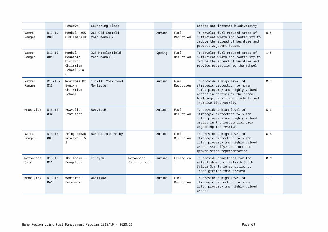
CFA Lead Agency Planned Burns 2020/21
Local Government Area
Burn Number
Burn Name GeneralLocation
Land Owner/Manager
BurnSeason
Burn Type(FRB/ECO)
Land Management Objective Planned Burn Size (ha)
Planned Burn Size (km)
Wangaratta Rural City
D23-20-016
Dockers Plains Dockers Plains Autumn Fuel Reduction To develop fuel reduced areas of sufficient width and continuity to reduce the spread of bushfire and provide buffer zone for the North Wangaratta and Wangaratta district
222.8
SCHEDULE 2: NON-BURN FUEL TREATMENTS 2018/19 - CFA Lead Agency
There are no non-burn fuel treatments scheduled.
Hume Region Joint Fuel Management Program 2018/19 – 2020/21 Page 69

CFA LEAD AGENCY 24 DISTRICT SCHEDULESCHEDULE 1: PLANNED BURNS The activities in this schedule are planned burns.
Please note that the planned burn year and season identified for each planned burn is indicative only and may be changed due to weather conditions and operational requirements.
Abbreviations in Schedule1: ‘*’ asterisk on burn name denotes a cross tenure burn; COM - Committee of Management; PP – Private Property; FRB - Fuel Reduction Burn; ECO - ecological burn;
CFA Lead Agency Planned Burns 2018/19
Local Government Area
Burn Number
Burn Name GeneralLocation
Land Owner/Manager
BurnSeason
Burn Type(FRB/ECO)
Land Management Objective Planned Burn Size (ha)
Planned Burn Size (km)
Alpine D24-18-098
RWHT-1 Carrolls Rd
Rosewhite Spring Fuel Reduction To provide a high level of strategic protection to human life, property and highly valued assets, HVP Pine Plantation.
1.08
Towong D24-18-031
SPRINGDALE RECREATION RESERVE BETH-9 -Sec1
Bethanga COM Spring Fuel Reduction To provide a high level of strategic protection to human life, property and highly valued assets.
2
Hume Region Joint Fuel Management Program 2018/19 – 2020/21 Page 70

CFA Lead Agency Planned Burns 2019/20
Local Government Area
Burn Number
Burn Name GeneralLocation
Land Owner/Manager
BurnSeason
Burn Type(FRB/ECO)
Land Management Objective Planned Burn Size (ha)
Planned Burn Size (km)
Wodonga City
D24-19-020
Avalon Road BDUD-12
Baranduda Autumn Fuel Reduction To provide a high level of strategic protection to human life, property and highly valued assets.
4.8
Indigo D24-19-049
Barkley St - RUTR-1
Rutherglen Autumn Fuel Reduction To develop fuel reduced areas of sufficient width and continuity to reduce the spread of bushfire.
3.3
Wodonga City
D24-19-008
Barnawartha Rail Reserve BAWA-7
Barnawartha Autumn Fuel Reduction To develop a fuel reduced corridor north east of the Barnawartha township.
20.8
Alpine D24-19-036
Barwidgee Creek - MUDG-7
Mudgegonga Autumn Fuel Reduction To develop fuel reduced areas of sufficient width and continuity to reduce the spread of bushfire.
1.2
Alpine D24-19-036
Barwidgee Creek - MUDG-8
Mudgegonga COMl Autumn Fuel Reduction To develop fuel reduced areas of sufficient width and continuity to reduce the spread of bushfire.
6
Indigo D24-19-066
Basin Creek Road - YACR-2
Yackandandah Autumn Fuel Reduction To develop fuel reduced areas of sufficient width and continuity to reduce the spread of bushfire.
4.2
Towong D24-19-055
Benambra Corryong Rd - NARI-2
Nariel Valley Autumn Fuel Reduction To develop fuel reduced areas of sufficient width and continuity to reduce the spread of bushfire.
3.7
Alpine D24-19-036
Black Flats Rd - MUDG-2
Mudgegonga Autumn Fuel Reduction To develop fuel reduced areas of sufficient width and continuity to reduce the spread of bushfire.
14.5
Wodonga City
D24-19-004
Boathaven Road BONA-10
Bonegilla Autumn Ecological To provide a high level of strategic protection to human life, property and highly valued assets and the Caravan Park.
1.3
Hume Region Joint Fuel Management Program 2018/19 – 2020/21 Page 71

Wangaratta Rural City
D23-19-049
Bobby Lane - BOWM-3
Bowmans Forest Autumn Fuel Reduction To develop fuel reduced areas of sufficient width and continuity to reduce the spread of bushfire.
4.9
Wodonga City
D24-18-004
Bonegilla Road - BONA-1
Bonegilla Autumn Fuel Reduction To develop fuel reduced areas of sufficient width and continuity to reduce the spread of bushfire.
4.5
Wodonga City
D24-19-020
Boyes Rd BDUD-13
Baranduda Autumn Fuel Reduction To provide a high level of strategic protection to human life, property and highly valued assets.
6.9
Wodonga City
D24-19-054
BOYES RD LEVA-3
Baranduda Autumn Fuel Reduction To provide an irregular mosaic of areas of fuel reduction which will complement works in adjacent fuel management zones
11.1
Towong D24-19-077
BRIGGS GAP RD - CONU-3
Corryong Autumn Fuel Reduction To develop a fuel reduced corridor along roadside to the township of Corryong.
13.5
Towong D24-19-034
Bryants Gap - TALU-4
Tallangatta Autumn Fuel Reduction To provide a high level of strategic protection to human life, property and highly valued assets.
5.2
Wangaratta Rural City
D23-19-049
BUCKLAND GAP RD - BOWM-12
Murmungee Autumn Fuel Reduction To develop fuel reduced areas of sufficient width and continuity to reduce the spread of bushfire.
5.9
Alpine D24-19-023
Buffalo River Rd - BUFR-2
Buffalo River COM Autumn Fuel Reduction To develop fuel reduced areas of sufficient width and continuity to reduce the spread of bushfire
2
Indigo D24-19-037
Carlyle Rd - CYLE-4
Carlyle Autumn Fuel Reduction To develop fuel reduced areas of sufficient width and continuity to reduce the spread of bushfire.
22.2
Alpine D24-19-036
Carrolls Rd - MUDG-1
Mudgegonga Autumn Fuel Reduction To develop fuel reduced areas of sufficient width and continuity to reduce the spread of bushfire.
15.9
Indigo D24-19-010
CHILTERN RAIL RESERVE CHIU-4
Chiltern Autumn Fuel Reduction To develop a fuel reduced corridor along the rail reserve of the Chiltern township.
53.4
Hume Region Joint Fuel Management Program 2018/19 – 2020/21 Page 72

Indigo D24-19-078
Cookinburra Road - INDI-2
Indigo Valley Autumn Fuel Reduction To develop fuel reduced areas of sufficient width and continuity to reduce the spread of bushfire.
25.1
Indigo D24-19-010
CornishTown Rd - CHIU-15
Chiltern Autumn Fuel Reduction To develop fuel reduced areas of sufficient width and continuity to reduce the spread of bushfire.
7
Indigo D24-19-035
Coulston Rd - KIEW-4
Kiewa Autumn Fuel Reduction To develop fuel reduced areas of sufficient width and continuity to reduce the spread of bushfire.
3.5
Indigo D24-19-012
Craven Lane - AFLT-3
Allans Flat Autumn Fuel Reduction To develop fuel reduced areas of sufficient width and continuity to reduce the spread of bushfire.
4.3
Towong D24-19-029
Cudgewa Valley Road - CUWA-1
Cudgewa Autumn Fuel Reduction To develop fuel reduced areas of sufficient width and continuity to reduce the spread of bushfire.
51.3
Alpine D24-19-036
DePiazzas Lane - MUDG-3
Mudgegonga Autumn Fuel Reduction To develop a fuel reduced corridor for the Mudgegonga township.
3
Wangaratta Rural City
D23-19-049
Dipyard Lane - BOWM-4
Murmungee Autumn Fuel Reduction To develop fuel reduced areas of sufficient width and continuity to reduce the spread of bushfire.
4.7
Alpine D24-19-030
Faheys Lane - DEDE-7
Dederang Autumn Fuel Reduction To develop fuel reduced areas of sufficient width and continuity to reduce the spread of bushfire.
5.3
Towong D24-19-032
Ferry Lane - GRYA-3
Granya Autumn Fuel Reduction To develop fuel reduced areas of sufficient width and continuity to reduce the spread of bushfire.
0.3
Indigo D24-19-015
FireStation - SCRK-2
Sandy Creek Autumn Fuel Reduction To develop fuel reduced areas of sufficient width and continuity to reduce the spread of bushfire.
0.2
Towong D24-19-005
Giltraps Flat - DMTH-7
Dartmouth Autumn Fuel Reduction To develop fuel reduced areas of sufficient width and continuity to reduce the spread of bushfire.
5.7
Alpine D24-19- Goonans Lane - Dederang Autumn Fuel Reduction To develop fuel reduced areas of 1.4
Hume Region Joint Fuel Management Program 2018/19 – 2020/21 Page 73
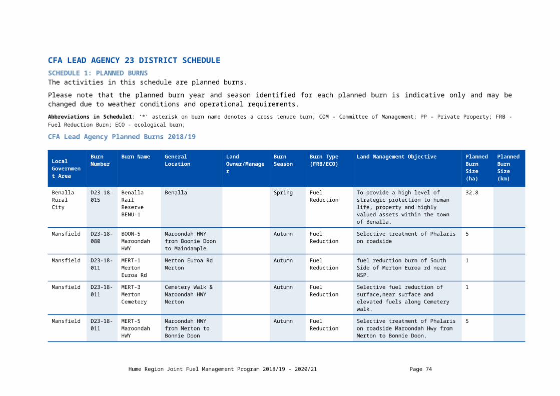
030 DEDE-9 sufficient width and continuity to reduce the spread of bushfire.
Towong D24-19-032
Granya Rd - GRYA-4
Granya Autumn Fuel Reduction To develop fuel reduced areas of sufficient width and continuity to reduce the spread of bushfire.
0.7
Alpine D24-19-030
Greens Lane - DEDE-5
Dederang Autumn Fuel Reduction To develop fuel reduced areas of sufficient width and continuity to reduce the spread of bushfire.
2.1
Indigo D24-19-041
Griffiths Lane - SLEY-9
Stanley Autumn Fuel Reduction To develop fuel reduced areas of sufficient width and continuity to reduce the spread of bushfire.
1.4
Indigo D24-19-033
Gundowring Rd - GUND-2
Gundowring Autumn Fuel Reduction To develop fuel reduced areas of sufficient width and continuity to reduce the spread of bushfire.
6.9
Alpine D24-19-033
Gundowring Rd - GUND-4
Gundowring Autumn Fuel Reduction To develop fuel reduced areas of sufficient width and continuity to reduce the spread of bushfire.
10.2
Indigo D24-19-033
Gundowring Road - GUND-1
Barnawartha Autumn Fuel Reduction To develop fuel reduced areas of sufficient width and continuity to reduce the spread of bushfire.
7.1
Indigo D24-19-049
Hallams Paris Rd - RUTR-8
Rutherglen Autumn Fuel Reduction To develop fuel reduced areas of sufficient width and continuity to reduce the spread of bushfire
36.3
Towong D24-19-034
Hardys Rd - TALU-5
Tallangatta Autumn Fuel Reduction To develop fuel reduced areas of sufficient width and continuity to reduce the spread of bushfire.
17.2
Indigo D24-19-066
Haring Lane - YACR-7
Y Autumn Fuel Reduction To develop fuel reduced areas of sufficient width and continuity to reduce the spread of bushfire.
1.3
Indigo D24-19-049
Herrins Rd - RUTR-2
Rutherglen Autumn Fuel Reduction To develop fuel reduced areas of sufficient width and continuity to reduce the spread of bushfire.
2.5
Towong D24-19- Horsfall Rd - Dartmouth Autumn Fuel Reduction To provide an irregular mosaic of areas of 1.7
Hume Region Joint Fuel Management Program 2018/19 – 2020/21 Page 74
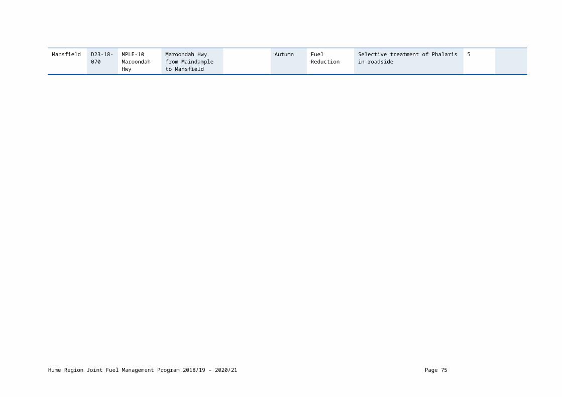
005 DMTH-5 fuel reduction which will complement works in adjacent fuel management zones and
Indigo D24-19-037
Humphreys Road - CYLE-3
Carlyle Autumn Fuel Reduction To develop fuel reduced areas of sufficient width and continuity to reduce the spread of bushfire.
11.8
Indigo D24-19-049
Jack Rd - RUTR-7
Rutherglen Autumn Fuel Reduction To develop fuel reduced areas of sufficient width and continuity to reduce the spread of bushfire.
54.7
Towong D24-19-026
KENNEDYS RESERVE - BWYE-2
Burrowye Autumn Fuel Reduction To develop fuel reduced areas of sufficient width and continuity to reduce the spread of bushfire.
2.5
Indigo D24-19-035
Kiewa East Rd - KIEW-8
Kiewa Autumn Fuel Reduction To develop fuel reduced areas of sufficient width and continuity to reduce the spread of bushfire
9.3
Wodonga City
D24-19-020
Kiewa Valley Highway - BDUD-1
Baranduda Autumn Fuel Reduction To develop fuel reduced areas of sufficient width and continuity to reduce the spread of bushfire.
27.6
Alpine D24-19-030
Kiewa Valley Hwy - DEDE-1
Dedrang Autumn Fuel Reduction To provide a high level of strategic protection to human life, property and highly valued assets
2.2
Alpine D24-19-030
KIEWA VALLEY HWY - DEDE-3
Dederang Autumn Fuel Reduction To develop fuel reduced areas of sufficient width and continuity to reduce the spread of bushfire.
2.3
Alpine D24-19-030
Kiewa Valley Hwy - DEDE-4
Dederang Autumn Fuel Reduction To develop fuel reduced areas of sufficient width and continuity to reduce the spread of bushfire.
11.2
Alpine D24-19-045
Kiewa Valley Hwy - TAWO-7
Tawonga Autumn Fuel Reduction To develop fuel reduced areas of sufficient width and continuity to reduce the spread of bushfire.
3.9
Indigo D24-19-035
Kiewa-Huon Rd - KIEW-1
Kiewa Autumn Fuel Reduction To develop fuel reduced areas of sufficient width and continuity to reduce the spread of bushfire.
11.7
Hume Region Joint Fuel Management Program 2018/19 – 2020/21 Page 75
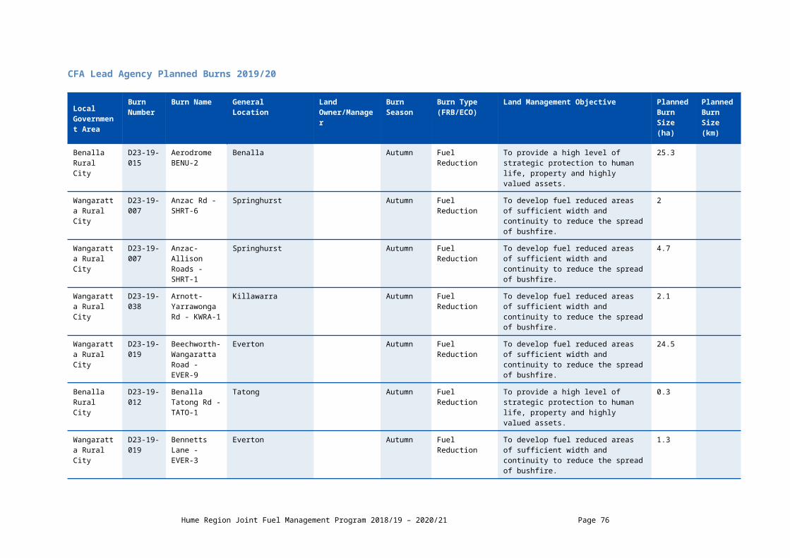
Indigo D24-19-049
Killeems Rd - RUTR-4
Rutherglen Autumn Fuel Reduction To develop fuel reduced areas of sufficient width and continuity to reduce the spread of bushfire.
3.5
Towong D24-19-007
Little Snowy Creek - ESKD-2
Eskdale Autumn Fuel Reduction To provide a high level of strategic protection to human life, property and highly valued assets.
10.9
Indigo D24-19-015
Lockharts Gap Road - SCRK-4
Sandy Creek Autumn Fuel Reduction To develop fuel reduced areas of sufficient width and continuity to reduce the spread of bushfire.
17
Indigo D24-19-015
Lockharts Gap Road - SCRK-5
Sandy Creek Autumn Fuel Reduction To develop fuel reduced areas of sufficient width and continuity to reduce the spread of bushfire.
6.5
Wodonga City
D24-19-004
Mahers Rd BONA-3
Bonegilla Autumn Fuel Reduction To develop a fuel reduced corridor South of the Bonegilla township.
28.6
Indigo D24-19-010
Marengos Road - CHIU-1
Chiltern Autumn Fuel Reduction To develop fuel reduced areas of sufficient width and continuity to reduce the spread of bushfire.
10.1
Indigo D24-19-078
Mares Flat Road - INDI-6
Indigo Valley Autumn Fuel Reduction To develop fuel reduced areas of sufficient width and continuity to reduce the spread of bushfire.
4.5
Alpine D24-19-034
Marrums Lane - MBTY-1
Mt Beauty Autumn Fuel Reduction To develop fuel reduced areas of sufficient width and continuity to reduce the spread of bushfire.
0.9
Indigo D24-19-078
Masons Gap Road - INDI-9
Indigo Valley Autumn Fuel Reduction To develop fuel reduced areas of sufficient width and continuity to reduce the spread of bushfire.
4.8
Towong D24-19-032
McFarlanes Lane - GRYA-2
Dartmouth Autumn Fuel Reduction To develop fuel reduced areas of sufficient width and continuity to reduce the spread of bushfire.
0.2
Indigo D24-19-012
Meehans Lane - AFLT-2
Allans Flat Autumn Fuel Reduction To develop fuel reduced areas of sufficient width and continuity to reduce the spread of bushfire.
1.5
Indigo D24-19- Mongan Lane - Yackandandah Autumn Fuel Reduction To develop fuel reduced areas of 2.1
Hume Region Joint Fuel Management Program 2018/19 – 2020/21 Page 76

066 YACR-8 sufficient width and continuity to reduce the spread of bushfire.
Alpine D24-19-033
Mongans Bridge - GUND-5
Gundowring Autumn Fuel Reduction To provide a high level of strategic protection to human life, property and highly valued assets.
11
Alpine D24-19-045
Mt Creek Road TAWO-2
Tawonga Autumn Fuel Reduction To develop fuel reduced areas of sufficient width and continuity to reduce the spread of bushfire.
7.5
Alpine D24-19-045
Mt Creek Road TAWO-6
Tawonga Autumn Fuel Reduction To develop fuel reduced areas of sufficient width and continuity to reduce the spread of bushfire.
6
Indigo D24-19-041
Mt Stanley Rd - SLEY-5
Stanley Autumn Fuel Reduction To develop fuel reduced areas of sufficient width and continuity to reduce the spread of bushfire.
1.7
Alpine D24-19-033
Mullagong Rd -GUND-3
Gundowring Autumn Fuel Reduction To develop fuel reduced areas of sufficient width and continuity to reduce the spread of bushfire.
10.3
Towong D24-19-011
Murray River Rd - WALW-1
Walwa Autumn Fuel Reduction To develop fuel reduced areas of sufficient width and continuity to reduce the spread of bushfire.
10.2
Towong D24-19-013
MURRAY RIVER ROAD - TALG-2
Talgarno Autumn Fuel Reduction To develop fuel reduced areas of sufficient width and continuity to reduce the spread of bushfire.
21.3
Towong D24-19-013
Murray River Road - TALG-5
Talgarno Autumn Fuel Reduction To develop fuel reduced areas of sufficient width and continuity to reduce the spread of bushfire.
66.4
Towong D24-19-047
Murray River Road - TINT-1
Tintaldra Autumn Fuel Reduction To develop fuel reduced areas of sufficient width and continuity to reduce the spread of bushfire.
37.8
Towong D24-19-047
Murray River Road - TINT-2
Tintaldra Autumn Fuel Reduction To develop fuel reduced areas of sufficient width and continuity to reduce the spread of bushfire.
6.3
Towong D24-19- Murray River Towong Autumn Fuel Reduction To develop fuel reduced areas of 5.3
Hume Region Joint Fuel Management Program 2018/19 – 2020/21 Page 77

047 Road - TINT-5 sufficient width and continuity to reduce the spread of bushfire.
Towong D24-19-055
Murray Valley Highway - NARI-1
Nariel Valley Autumn Fuel Reduction To develop fuel reduced areas of sufficient width and continuity to reduce the spread of bushfire.
10.3
Towong D24-19-034
Murray Valley Highway - TALU-1&2
Tallangatta COM Autumn Fuel Reduction To develop fuel reduced areas of sufficient width and continuity to reduce the spread of bushfire.
35.1
Towong D24-19-034
Murray Valley Highway - TALU-3
Tallangatta COM Autumn Fuel Reduction To develop fuel reduced areas of sufficient width and continuity to reduce the spread of bushfire.
19
Towong D24-19-006
Murray Valley Hwy - BIOH-1
Billioh Autumn Fuel Reduction To develop fuel reduced areas of sufficient width and continuity to reduce the spread of bushfire.
26.2
Towong D24-19-006
Murray Valley Hwy - BIOH-2
Koetong Autumn Fuel Reduction To develop fuel reduced areas of sufficient width and continuity to reduce the spread of bushfire.
21.7
Wodonga City
D24-19-004
Murray Valley Hwy - BONA-7
Bonegilla Autumn Fuel Reduction To reduce overall biomass and to encourage assemblage of native grasses.
27.7
Towong D24-19-077
Murray Valley Hwy - CONU-2
Corryong Autumn Fuel Reduction To develop fuel reduced areas of sufficient width and continuity to reduce the spread of bushfire.
35.8
Towong D24-19-077
Murray Valley Hwy - CONU-4
Corryong Autumn Fuel Reduction To develop fuel reduced areas of sufficient width and continuity to reduce the spread of bushfire.
8.6
Indigo D24-19-035
Murray Valley Hwy - KIEW-6
Huon COM Autumn Fuel Reduction To reduce overall biomass and to encourage assemblage of native grasses.
15.9
Alpine D24-18-036
MYRTLEFORD-YACK RD - MUDG-5
Mudgegonga Autumn Fuel Reduction To develop fuel reduced areas of sufficient width and continuity to reduce the spread of bushfire.
4.9
Indigo D24-19-066
Myrtleford-Yack Rd - YACR-4
Yackandandah Autumn Fuel Reduction To develop fuel reduced areas of sufficient width and continuity to reduce the spread of bushfire.
2.9
Hume Region Joint Fuel Management Program 2018/19 – 2020/21 Page 78

Alpine D24-19-023
Nug Nug Rd -BUFR-1
Buffalo River Autumn Fuel Reduction To develop fuel reduced areas of sufficient width and continuity to reduce the spread of bushfire.
1.9
Alpine D24-19-038
Old Ovens - MYRU-2
Myrtleford Autumn Fuel Reduction To provide an irregular mosaic of areas of fuel reduction which will complement works in adjacent fuel management zones
4.1
Towong D24-19-007
Omeo Highway - ESKD-1
Eskdale Autumn Fuel Reduction To develop fuel reduced areas of sufficient width and continuity to reduce the spread of bushfire.
34.2
Indigo D24-19-012
Osbornes Flat Rd - AFLT-10
Allans Flat Autumn Fuel Reduction To develop fuel reduced areas of sufficient width and continuity to reduce the spread of bushfire.
0.6
Indigo D24-19-066
OSBORNES FLAT RD - YACR-10
Yackandandah Autumn Fuel Reduction To develop fuel reduced areas of sufficient width and continuity to reduce the spread of bushfire.
6.7
Alpine D24-19-036
Pini Lane - MUDG-6
Mudgegonga Autumn Fuel Reduction To develop fuel reduced areas of sufficient width and continuity to reduce the spread of bushfire.
11
Indigo D24-19-041
Pioneer Rd - SLEY-8
Stanley Autumn Fuel Reduction To develop fuel reduced areas of sufficient width and continuity to reduce the spread of bushfire.
1.1
Alpine D24-19-030
Police Lane - DEDE-11
Dederang Autumn Fuel Reduction To develop fuel reduced areas of sufficient width and continuity to reduce the spread of bushfire.
1.4
Indigo D24-19-066
Racecourse Road - YACR-9
Yackandandah Autumn Fuel Reduction To develop fuel reduced areas of sufficient width and continuity to reduce the spread of bushfire.
17.3
Indigo D24-19-049
Rail Trail - RUTR-9
Rutherglen Autumn Fuel Reduction To develop fuel reduced areas of sufficient width and continuity to reduce the spread of bushfire.
3.7
Wangaratta Rural City
D23-19-036
RAIL TRAIL - WNTH-1
Wangaratta North Autumn Fuel Reduction To develop fuel reduced areas of sufficient width and continuity to reduce
15.6
Hume Region Joint Fuel Management Program 2018/19 – 2020/21 Page 79

the spread of bushfire.
Wodonga City
D24-19-004
Rail Trail Ludlow Reserve - BONA-9
Bonegilla COM Autumn Fuel Reduction To develop fuel reduced areas of sufficient width and continuity to reduce the spread of bushfire.
16.8
Indigo D24-19-049
Ready St West - RUTR-3
Rutherglen Autumn Fuel Reduction To develop fuel reduced areas of sufficient width and continuity to reduce the spread of bushfire.
0.8
Indigo D24-19-015
Red Bluff SCRK-1
Sandy Creek Autumn Fuel Reduction To develop fuel reduced areas of sufficient width and continuity to reduce the spread of bushfire.
1
Alpine D24-19-045
Redbank Tk - TAWO-5
Tawonga Autumn Fuel Reduction To develop fuel reduced areas of sufficient width and continuity to reduce the spread of bushfire.
5.6
Indigo D24-19-066
Richardsons Race Rd - YACR-11
Yackandandah Autumn Fuel Reduction To develop fuel reduced areas of sufficient width and continuity to reduce the spread of bushfire.
2
Alpine D24-19-030
Rogers Land - DEDE-13
Dederang Autumn Fuel Reduction To develop fuel reduced areas of sufficient width and continuity to reduce the spread of bushfire.
2
Alpine D24-19-030
Running Creek Road - DEDE-6
Dederang Autumn Fuel Reduction To develop fuel reduced areas of sufficient width and continuity to reduce the spread of bushfire
15.9
Alpine D24-19-030
Running Creek Road - DEDE-8
Dederang Autumn Fuel Reduction To develop fuel reduced areas of sufficient width and continuity to reduce the spread of bushfire.
8.6
Indigo D24-19-012
Scholz Rd - AFLT-4
Allans Flat Autumn Fuel Reduction To develop fuel reduced areas of sufficient width and continuity to reduce the spread of bushfire.
7
Indigo D24-19-037
Shaws Flat Road - CYLE-2
Carlyle Autumn Fuel Reduction To develop fuel reduced areas of sufficient width and continuity to reduce the spread of bushfire.
10.3
Towong D24-19-078
Shelley Walwa Road - SHPL-1
Shelley Autumn Fuel Reduction To develop fuel reduced areas of sufficient width and continuity to reduce
20.5
Hume Region Joint Fuel Management Program 2018/19 – 2020/21 Page 80

the spread of bushfire.
Towong D24-19-031
Springdale Recreation Reserve BETH-9
Bethanga COM Autumn Fuel Reduction To provide a high level of strategic protection to human life, property and highly valued assets.
4.6
Indigo D24-19-041
Stanley Myrtleford Road - SLEY-6
Stanley Autumn Fuel Reduction To develop fuel reduced areas of sufficient width and continuity to reduce the spread of bushfire.
1.7
Indigo D24-19-010
Stormwater Channel - CHIU-16
Chiltern Autumn Fuel Reduction To develop fuel reduced areas of sufficient width and continuity to reduce the spread of bushfire.
1.4
Alpine D24-19-030
Streets Lane - DEDE-12
Dederang COM Autumn Fuel Reduction To develop fuel reduced areas of sufficient width and continuity to reduce the spread of bushfire.
0.9
Towong D24-19-005
Tabor Creek DMTH-3
Dartmouth Autumn Fuel Reduction To develop fuel reduced areas of sufficient width and continuity to reduce the spread of bushfire.
2.2
Towong D24-19-013
Talgarno Gap Road - TALG-6
Talgarno Autumn Fuel Reduction To develop a fuel reduced corridor South of the Talgarno township.
39.6
Towong D24-18-047
TOWONG HILL Towong Hill Autumn Fuel Reduction To provide a high level of strategic protection to human life, property and highly valued assets of Towong.
2.1
Towong D24-19-024
TOWONG HILL RD - BIGG-2
Biggara Autumn Fuel Reduction To provide a high level of strategic protection to human life, property and highly valued assets.
13.4
Alpine D24-19-036
Tunnel Gap - MUDG-10
Mudgegonga Autumn Fuel Reduction To develop fuel reduced areas of sufficient width and continuity to reduce the spread of bushfire.
4.3
Indigo D24-19-037
Upriver Road - CYLE-1
Carlyle Autumn Fuel Reduction To develop fuel reduced areas of sufficient width and continuity to reduce the spread of bushfire.
69.3
Wangaratta Rural City
D23-19-004
Wangaratta-Eldorado Rd -
Eldorado Autumn Fuel Reduction To develop fuel reduced areas of sufficient width and continuity to reduce
0.8
Hume Region Joint Fuel Management Program 2018/19 – 2020/21 Page 81

ELDO-3 the spread of bushfire.
Wangaratta Rural City
D23-19-004
WANGARATTA-ELDORADO RD - ELDO-4
Eldorado Autumn Fuel Reduction To develop fuel reduced areas of sufficient width and continuity to reduce the spread of bushfire.
0.1
Indigo D24-19-078
Watchbox Road - INDI-10
Indigo Valley Autumn Fuel Reduction To develop fuel reduced areas of sufficient width and continuity to reduce the spread of bushfire.
10.1
Towong D24-19-032
WEBBS LANE - GRYA-1
Granya Autumn Fuel Reduction To develop a fuel reduced corridor along roadside of the Granya township.
1.9
Towong D24-18-047
WERMATONG HILL1
Wermatong Hill Autumn Fuel Reduction To develop fuel reduced areas of sufficient width and continuity to reduce the spread of bushfire and to create a strategic buffer zone for Corryong and adjacent district.
42.68
Wodonga City
D24-19-051
Wodonga West RAIL RESERVE WWST-1
Wodonga West Autumn Fuel Reduction To develop a fuel reduced corridor west of the Wodonga West township.
30.2
Wodonga City
D24-19-054
Wodonga-Beechworth Rd - LEVA-2
Leneva Autumn Fuel Reduction To develop fuel reduced areas of sufficient width and continuity to reduce the spread of bushfire
83.6
Alpine D24-19-036
Woodside Lane - MUDG-4
Mudgegonga Autumn Fuel Reduction To develop fuel reduced areas of sufficient width and continuity to reduce the spread of bushfire
3.6
Hume Region Joint Fuel Management Program 2018/19 – 2020/21 Page 82
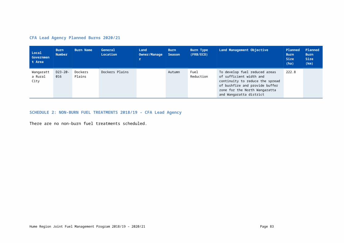
CFA Lead Agency Planned Burns 2020/21
Local Government Area
Burn Number
Burn Name GeneralLocation
Land Owner/Manager
BurnSeason
Burn Type(FRB/ECO)
Land Management Objective Planned Burn Size (ha)
Planned Burn Size (km)
Towong D24-20-099
Klippels Rd Klippels Rd Autumn Fuel Reduction To provide an irregular mosaic of areas of fuel reduction which will complement works in adjacent fuel management zones and asset protection to adjacent forestry assets
122.8
Alpine D24-20-023
Reedy Creek - Bufr-3
Buffalo River Autumn Fuel Reduction To develop fuel reduced areas of sufficient width and continuity to reduce the spread of bushfire.
0.8
Towong D24-20-047
Wermatong Hill3
Wermatong Hill Autumn Fuel Reduction To develop fuel reduced areas of sufficient width and continuity to reduce the spread of bushfire and buffer zone for Corryong and surrounding district.
266
Hume Region Joint Fuel Management Program 2018/19 – 2020/21 Page 83

SCHEDULE 2: NON-BURN FUEL TREATMENTS 2018/19 - CFA Lead Agency The table below contains a summary of proposed non-burn fuel treatments over the following year. Some of these fuel treatments are annual, with others prioritised based on the seasonal conditions and which planned burns are scheduled. Accompanying maps provide detail on where these fuel treatment activities are located. Note that the maps show approximate areas only and the actual treatment area will be dependent on the condition of the fuels at the time of assessment. Please contact your local CFA office if further detail is required.
Works by TypeMulching (ha)
Slashing(ha)
Other(ha)
Hectares Planned 5.5 27.7 153.5
Hume Region Joint Fuel Management Program 2018/19 – 2020/21 Page 84

GlossaryThis glossary provides information on terms contained within the body of this document and the schedules.
Burn Type – indicates the primary purpose of the burn including fuel reduction burn (FRB), ecological burn (ECO).
Burn Number and Name– the unique identifier for each burn or planned fuel management activity.
Cross-tenure burn – burns that cover both public and private land
Fire Management Zone (FMZ) – an area of public land in which fire is managed for specific asset, fuel and ecological objectives. Values included in this column can be APZ - Asset Protection Zone; BMZ – Bushfire Moderation Zone; LMZ - Landscape Management Zone, PBEZ – Planned Burn Exclusion Zone; or, NZ -Not Zoned.
Forest Fire Management Victoria (FFMVic) - is the organisation that delivers services to achieve DELWP’s legislated responsibilities. It consists of specialist staff from DELWP, Parks Victoria, Melbourne Water and VicForests.
Indicative Burn Season – indicates the preferred season in which the burn will be completed. Actual delivery may be any time of the year.
Land Manager – the organisation responsible for day-to-day management of the works site – DELWP (Department of Environment Land Water and Planning); PV (Parks Victoria).
Land Management Objective - identifies the desired land management outcome(s) of the burn.
Local Government Area (LGA) – the municipality in which the majority of the fuel management activity is located.
Location – a direction and distance of the planned burn from the nearest major township/locality.
Planned Burns - Planned burning is one of FFMVic and CFA’s most important fire prevention activities. It involves the controlled application of fire during periods of lower fire risk, to achieve one of three main purposes: fuel reduction, ecological management and forest regeneration.
It is important to understand that planned burning operations, particularly fuel reduction burns, do not stop or eliminate the risk of bushfires. However, Victorian research, and similar information from other parts of Australia and overseas, clearly shows that firefighters have a much better chance of managing bushfires in areas where fuel reduction burns have been carried out.
Approved burns in this year’s Plan will require a range of preparation works to make the planned area ready to ignite when the weather and other conditions are right. Preparation works may include, brushing up or grading of existing boundaries and internal tracks, management of hazardous trees, the construction and preparation of boundary and control lines with machinery and pest plant controls. The preparation works will have on-site inspections which will assess the surrounding assets and planned burn objectives.
Private Property Burn – burn that occurs wholly on private land.
Planned Burn Size – the maximum area of the fuel management activity measured in hectares (ha), including areas specifically excluded from disturbance.
Strategic Fuelbreak: A strategic fuelbreak is a strip of land where vegetation has been modified to reduce the amount of fuel available to burn during a bushfire.
New Burn– ‘NEW’ = New burn did not appear on last year’s FFMVic JFMP. Blank box = Not a new burn. Burn was approved in the previous (2017/18- 2019/20) Fire Operations Plan but has not been carried out, it is included in this JFMP and may be conducted at any time.
Non-Burn Fuel Treatments – Non burn fuel treatments such as the maintenance and construction of fire control lines, fire access tracks, fuel breaks, fire infrastructure and other fuel management activities are required to support the planned burning program. Treatments to achieve these works can include slashing, pruning, chemical application (in alignment with safety standards), grazing or other operations (such as ploughing, mulching or rolling) that may be more appropriate or practical in certain areas. For example, fuel on small areas or blocks located within townships may be treated mechanically, where burning is impractical. These methods may also be more suitable in certain vegetation types.
Hume Region Joint Fuel Management Program 2018/19 – 2020/21 Page 85