Embed Size (px)
Citation preview

Copyright © 2010 Petrosys Pty. Ltd.
pg 3
PETROSYS ASIA EXPANSION
READ ABOUT THE EXCITING CHANGES TAKING PLACE IN OUR KUALA LUMPUR OFFICE, AND CATCH UP ON GENERAL EVENTS IN THE REGION.
EDITION Number 13 Unearth A Masterpiece.
Newsletter of “The Mapping Guru”
pg 2
V16.7sp2 RELEASED
THIS ARTICLE HIGHLIGHTS SOME OF THE KEY FEATURES OF THE RECENTLY RELEASED V16.7SP2.
pg 4
CHECKSHOT NOW IN WDF
WE EXPLAIN WHAT A CHECKSHOT SURVEY IS, HOW TO IMPORT A SURVEY INTO A WDF AND HOW TO USE THE SURVEY DATA IN PETROSYS.
pg 6
PPDM 3.8 CULTURE COMPLIANCY
CLIENTS WITH THE PETROSYS DBMAP SPATIAL OPTION WILL BENEFIT FROM SPATIALISATION OF THE PETROSYS DBMAP CULTURE MODULE. DISCOVER HOW.
pg 8
DEAR STEVE...
CHECK OUT OUR NEW HANDY HINTS AND TIPS COLUMN! IN THIS EDITION STEVE ANSWERS A QUESTION ABOUT EXPORTING TO SHAPE WITHOUT LEAVING THE MAPPING CANVAS.
Petrosys has introduced webinars to the range of events available to new and existing users. The webinars are a free and easy way to get insight, information and demonstrations of Petrosys products and workflows. Learn from Petrosys Mapping Gurus at your desk, listen to software tips and tricks, learn about new features, get started with our products and more. Upcoming webinars are: The Petrosys plug-in for Petrel - Integrated Workflows Presenter: Nathan Balls Date/time: June 28 2010, 3pm (UTC +1) Geoscientists and engineers using Petrel can learn how to present their insight, integrated from several data sources, with the benefits of the Petrosys plug-in. What's New in Petrosys v16.8 Presenter: Andrew Weller Date/time: July 8 2010, 1pm (UTC +8) Discover ways in which the features and enhancements of v16.8 can streamline your workflows. Jump Start to Using Petrosys Presenter: Andrew Weller Date/time: July 22 2010, 10am (UTC -5) A session to quickly get you acquainted with the core workflows and operations of our software. Click here to visit our website and register <
Webinars Launched

Highlights of Petrosys release v16.7sp2
Australasia: +61 8 8227 2799 Americas: 1888 PETROSYS Europe: +44 141 420 6555 Calgary: +1 403 537 5600 2
Six Additional CRS Projections Available Petrosys now supports six new projections, which will be particularly helpful to those creating maps in the higher latitudes or on a global scale. The new projection methods enable dependent pre-defined EPSG CRSs and are available when creating custom CRSs:
• Polar Stereographic (Variant B) • Polar Stereographic (Variant C) • Lambert Azimuthal Equal Area • Equidistant Cylindrical • Equidistant Cylindrical (Spherical) (aka
Plate Carree) • Hammer Hammer and Lambert Azimuthal Equal Area both represent area accurately,
while the additional stereographic projections are useful in polar areas and are required by some national coordinate systems. The simple projection Plate Carree can be appropriate for mapping geographic coordinates where no true projection information is available. Addition of these projection methods enhances Petrosys' mapping capability and improves data compatibility with 3rd party software packages (such as ArcMap, GeoFrame and OpenWorks). Upgraded CRS Database: EPSG v7.4 This release of Petrosys includes an upgrade to the Petrosys CRS database to bring it in line with EPSG version 7.4 (25 Nov 2009), which allows the selection of many new CRSs. The database upgrade will be automatically applied whenever possible during installation to ensure access to the most current data is available. Please refer to installation guide or online
help for more details on the upgrade process. Support for Zone Intervals in WDF Well Data Files now allow users to define zones that are intervals where the top and base depth of the zone are based on one of the following: • Existing zone - pick the top or base
depth of a zone from another class, which does not contain intervals
• Well header depth - choose either the Depth datum or Final TD of the well
• User defined depth (SS) - enter a specific subsea depth value
The most common use is to define an interval between two existing zones. Once you have defined the zone interval, it is available for use with mapping and gridding in exactly the same way as a normal zone. Web Map Service (WMS) Image Display WMS imagery can now be displayed on Petrosys maps using the Display/Picture/Raster option. WMS images are standard raster data formats (such as png and jpeg) that are accessed from a web server instead of being read from a file based source. All kinds of imagery are available from WMS servers, including satellite and aerial photography, with many sources free for use.
Petrosys allows for a pre-configured list of servers to be made available to all users on a project or site basis for easy access and control. Providing images and maps via WMS instead of files can assist greatly with management of digital assets.
Petrosys is supported on a very diverse range of operating systems. Over the past few years our 'platform compatibility' has steadily widened with the introduction of 64-bit variants of Windows and RedHat Linux, as well as with significant changes in the Windows 32-bit environment. Portability brings a range of costs with it, as we have to maintain separate software build, testing and deployment processes for each operating system on which you can run the Petrosys application. To keep this overhead manageable, Petrosys will not be supported under the Solaris operating system starting with Version 17. Petrosys 17 is currently in the early stages of development. An informal survey of Petrosys sites and other applications vendors shows that having to include Solaris support would be an unnecessary constraint on what promises to be one of the most radically
improved versions of our system in the past 10 years. Our continuously improved support for Linux provides an effective and state-of-the-art platform for sites that prefer a Unix-like environment or have a Unix based applications suite. The Petrosys 16 stream will continue to be supported under Solaris. This software will continue to operate in a stable Solaris environment for as long as the hardware will handle it. However, updates to Solaris beyond the end of 2010 may no longer be supported by legacy versions of Petrosys. The operating system in which you chose to host your Oracle databases is not affected by this decision. Databases hosted on Solaris systems will continue to be visible to Petrosys. Please contact Petrosys support if you have any questions or comments on this matter.
Petrosys 17 Phases Out Solaris Support

Petrosys Asia expands
General: [email protected] > Support: [email protected] > Web: www.petrosys.com.au 3
A lot has been happening in the Petrosys SE Asian Regional Office over the past few months, with the hiring of 2 new staff and a change in office location. Petrosys has opened an office in the Menara Maxis Tower, next to KLCC - centrally located to all our clients. Our new address is: Petrosys (SE Asian Office) Level 36, Menara Maxis Kuala Lumpur City Centre Kuala Lumpur 50088 Malaysia Phone: +60 3 2772 7357 Fax: +60 3 2615 0088 Email - support: [email protected] Email - general: [email protected]
The Petrosys Asian office is managed by Michael Brumby, who has been based in Kuala Lumpur for the past 2 years. We recently hired 2 additional staff to assist Mike in supporting and growing Petrosys usage in the Asia and Middle East regions. We would like to take this opportunity to introduce you to Banuprevathy A P Panjateharam (Banu) and Siau Ch'ing Tan (Siau Ch'ing).
Banu and Siau Ch'ing both graduated with honours in Geology at the University of Malaya in August 2009. Banu's final project was a geological and geohazards study of Northern Pulau Pinang, Malaysia. Since graduating, Banu worked as a research assistant at the University and tutoring school students. Siau Ch'ing's final project was a geological study focusing on the oil spill vulnerability of the coastal region of northern Penang. Since graduating, she worked as a research assistant at the University and as a junior geologist in a construction company in Seremban. Banu and Siau Ch’ing have both spent 3 weeks in the Petrosys Australian offices (Perth and Adelaide) meeting the Petrosys staff, learning about the
software and enjoying the Australian summer. Clients in the Middle east / Asian region can now call the Petrosys Kuala Lumpur office directly for support. Banu and Siau Ch’ing will be happy to take your call and to answer all your questions - but please be patient with them as they are still in the process of learning the software. Banu is fluent in English, Bahasa Malaysia, Mandarin and Tamil, whilst Siau Ch’ing speaks English, Bahasa Malaysia and Mandarin.
Other News Hyderabad 2010 Conference Earlier this year Petrosys exhibited at the SPG 2010 Conference in Hyderabad, India. It was a very successful show with one of the highlights, a Dhonni cricket bat and ball which were raffled off, attracting a lot of interest from registrants. The lucky winner of the bat was Mr M.K. Mathur (Chief Manager (Programming)) from ONGC GEOPIC. The bat proved to be a winner in every sense - we later heard that the first time it was used, the batsman scored a century! The winner of the cricket ball was Prem Kumar (Geophysicist) with Cairn India.
Petronas Carigali support As part of Petrosys’ agreement with Petronas Carigali, Banu and Siau Ch’ing will be spending a few days a week onsite providing Petrosys support to the Petronas user base. Their recent first visit saw them assisting with some data
transfer. PGCE 2010 Conference Petrosys also recently exhibited at the PGCE 2010 Conference in Kuala Lumpur, Malaysia. It was a very buoyant event with many guests from Petronas and other Malaysian based companies attending, many of which stopped to visit our booth. Congratulations to the winner of the IPOD raffle prize - Mark Flynn from Carigali-Hess.
Above: Banu (left) and Siau Ch’ing (right) at Cleland Wildlife Park, just outside Adelaide.
Left: Menara Maxis building with the Petronas Twin Towers in the background.
From left: Rakesh Sharmar (Reservoil), Mike Brumby, bat winner Mr M K Mathur (ONGC) and ball winner Prem Kumar (Cairn Energy).
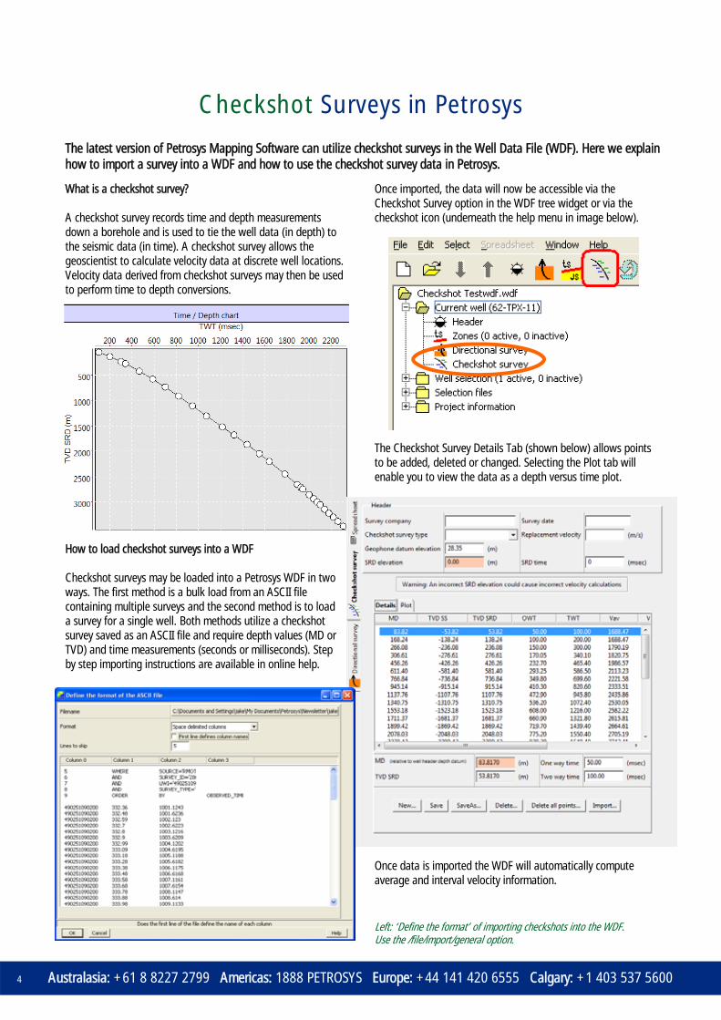
Checkshot Surveys in Petrosys
Australasia: +61 8 8227 2799 Americas: 1888 PETROSYS Europe: +44 141 420 6555 Calgary: +1 403 537 5600 4
What is a checkshot survey? A checkshot survey records time and depth measurements down a borehole and is used to tie the well data (in depth) to the seismic data (in time). A checkshot survey allows the geoscientist to calculate velocity data at discrete well locations. Velocity data derived from checkshot surveys may then be used to perform time to depth conversions.
How to load checkshot surveys into a WDF Checkshot surveys may be loaded into a Petrosys WDF in two ways. The first method is a bulk load from an ASCII file containing multiple surveys and the second method is to load a survey for a single well. Both methods utilize a checkshot survey saved as an ASCII file and require depth values (MD or TVD) and time measurements (seconds or milliseconds). Step by step importing instructions are available in online help.
Once imported, the data will now be accessible via the Checkshot Survey option in the WDF tree widget or via the checkshot icon (underneath the help menu in image below).
The Checkshot Survey Details Tab (shown below) allows points to be added, deleted or changed. Selecting the Plot tab will enable you to view the data as a depth versus time plot.
Once data is imported the WDF will automatically compute average and interval velocity information.
The latest version of Petrosys Mapping Software can utilize checkshot surveys in the Well Data File (WDF). Here we explain how to import a survey into a WDF and how to use the checkshot survey data in Petrosys.
Left: ‘Define the format’ of importing checkshots into the WDF. Use the /file/import/general option.

Checkshot Surveys in Petrosys
General: [email protected] > Support: [email protected] > Web: www.petrosys.com.au 5
What can you do with them in Petrosys? Petrosys has the ability to store a single checkshot survey for each well in the Well Data File (WDF). The data can be loaded, saved, viewed and edited through the Petrosys well editor. Zone velocity values are computed automatically and can be viewed by adding the velocity attributes to a spreadsheet in the well editor. These velocities can also be used in depth conversion or can be displayed on a map.
They can also be displayed as an annotation on the map by modifying the layer displaying the WDF and setting the display parameters under the Zones + Data tab. They may also be used as inputs for gridding operations. Velocity grids can be used in grid arithmetic to perform time to depth conversions. These can be handy if there is a lack of depth data, but a large amount of seismic data over the area of interest. You can also use these velocity attributes to create bubble maps representing zone velocity values at discrete locations. A quick guide to gridding zone velocities. 1. From the main Petrosys menu, open Grid, Contour,
Volumetrics. 2. Select Grid/Create grid. 3. Select Input data and add Wells/WDF as the data type. 4. Select your WDF and set up the panel (right) to grid one
of the zone velocity attributes. 5. Once the input data setup is complete, go back to the
main Petrosys gridding control panel and set the output grid name.
6. Set the options on the other panels as required and run the gridding process.
Below: xxxxxxxxxxxxxxxxxxxxxxxxxxxxxxx
Right: Choose the zone velocity attributes to be used in grid and depth conversion workflows.
Below: Zone velocity spreadsheet, along with direct posting of velocity information at well location or along well path.
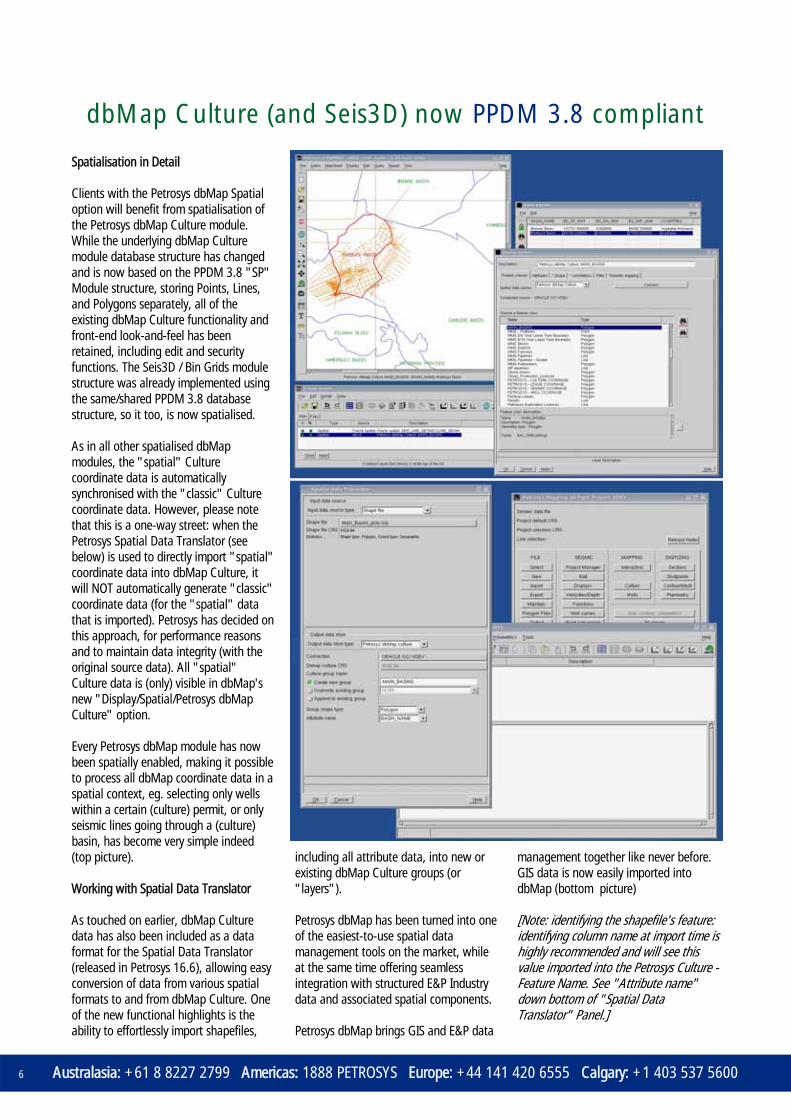
dbMap Culture (and Seis3D) now PPDM 3.8 compliant
Australasia: +61 8 8227 2799 Americas: 1888 PETROSYS Europe: +44 141 420 6555 Calgary: +1 403 537 5600 6
Spatialisation in Detail Clients with the Petrosys dbMap Spatial option will benefit from spatialisation of the Petrosys dbMap Culture module. While the underlying dbMap Culture module database structure has changed and is now based on the PPDM 3.8 "SP" Module structure, storing Points, Lines, and Polygons separately, all of the existing dbMap Culture functionality and front-end look-and-feel has been retained, including edit and security functions. The Seis3D / Bin Grids module structure was already implemented using the same/shared PPDM 3.8 database structure, so it too, is now spatialised. As in all other spatialised dbMap modules, the "spatial" Culture coordinate data is automatically synchronised with the "classic" Culture coordinate data. However, please note that this is a one-way street: when the Petrosys Spatial Data Translator (see below) is used to directly import "spatial" coordinate data into dbMap Culture, it will NOT automatically generate "classic" coordinate data (for the "spatial" data that is imported). Petrosys has decided on this approach, for performance reasons and to maintain data integrity (with the original source data). All "spatial" Culture data is (only) visible in dbMap's new "Display/Spatial/Petrosys dbMap Culture" option. Every Petrosys dbMap module has now been spatially enabled, making it possible to process all dbMap coordinate data in a spatial context, eg. selecting only wells within a certain (culture) permit, or only seismic lines going through a (culture) basin, has become very simple indeed (top picture). Working with Spatial Data Translator As touched on earlier, dbMap Culture data has also been included as a data format for the Spatial Data Translator (released in Petrosys 16.6), allowing easy conversion of data from various spatial formats to and from dbMap Culture. One of the new functional highlights is the ability to effortlessly import shapefiles,
including all attribute data, into new or existing dbMap Culture groups (or "layers"). Petrosys dbMap has been turned into one of the easiest-to-use spatial data management tools on the market, while at the same time offering seamless integration with structured E&P Industry data and associated spatial components. Petrosys dbMap brings GIS and E&P data
management together like never before. GIS data is now easily imported into dbMap (bottom picture) [Note: identifying the shapefile's feature: identifying column name at import time is highly recommended and will see this value imported into the Petrosys Culture - Feature Name. See "Attribute name" down bottom of "Spatial Data Translator" Panel.]

General: [email protected] > Support: [email protected] > Web: www.petrosys.com.au 7
Ever wanted a quick way to find out what files are associated with a well without the need to navigate through endless levels of directories? To produce the Well Report file listing you simply click on a well with the right mouse button, select Run External Script and choose the report you wish to run, such as the example, ‘Find Well Reports’. The script will search through your nominated filing area from the top directory level through all subdirectories for all matches it finds for the well. Simply navigate through the file list and double click a file to view. This feature can be run from any dbMap or third party connection. e.g. SMT, OpenWorks, GeoFrame etc. Contact Petrosys Support if you wish to know more about this feature. This script is Linux and Windows compatible. It can also be run against seismic lines.
Displaying a file listing from the click of a well
New Petrosys trainer
Cathy has been in the Oil and Gas industry for over 15 years after gaining her honours degree in Geophysics at Adelaide University. She
initially worked for Santos, first in the Operations Geophysics department and then as an interpreter in the Moomba Team. It was during this time that she developed a keen interest in Geostatistics. A move overseas saw her working for Rohoel Aufsuchungs (RAG) in Vienna, Austria, which gave her the opportunity to broaden her skill set, both geologically, linguistically and on the slopes! An impending expansion of her family saw a return to Australia where she started working for Petrosys in 2003, initially as a user oriented tester.
Today, Cathy is still involved with testing, as well as writing help documentation. Her role has recently broadened into training after completing the ‘Train the Trainer’ course and becoming an accredited trainer. The program is run by the Australian Institute of Management, and is designed to provide new trainers with the skills and knowledge to plan and present effective and interactive training sessions. Currently Cathy is running the Introduction to Petrosys course to Australian clients, both in a public forum and in-house, but is looking to expand into other areas. She enjoys the travel opportunities that training provides, meeting new people and showing them the vast array of possibilities that Petrosys software offers. She particularly likes working with clients on a one-on-one basis to help them develop their Petrosys workflows.
Public Training Courses
If you want to improve your skills, project or team capabilities, our training programs and resources can help you achieve your goals.
USA - Houston
2 Day Overview Unearthing the Reservoir Limits
Calculating Accountable Volumes
Jun 15-16 Jun 30
Jun 30
Europe - Glasgow
1 Day Overview Sep 15
Australia - various
2 Day Overview - Perth 2 Day Overview - Sydney
Jul 1-2 Aug 19-20
Malaysia - Kuala Lumpur
1 Day Overview Mapping of Geological Well Data
Mapping of Interpreted Seismic Data
Jul 12 Jul 13
Jul 14
Consult the Training page on www.petrosys.com.au for more courses throughout 2010, up to date schedules, prices and booking.

Short Takes...
General: [email protected] > Support: [email protected] > Web: www.petrosys.com.au 8
Andrew's route to Petrosys has been mostly academic. He received a BSc (Hons) in Geology from the University of Southampton (UK), which he followed with a MSc in Computing in Earth Sciences from Keele University (UK). After taking some time out having fun teaching English as a foreign language at a kindergarten in Taiwan, Andrew pursued a PhD in Micropalaeontology, Image Analysis and Pattern Recognition at the University of Glamorgan (UK). After his PhD, Andrew spent time in Switzerland gaining postdoctoral experience at the Swiss Federal Institute of Technology ("ETH"), Zurich. As well as making the most of the Swiss Alps as a backdrop, he had the opportunity to teach a number of MSc courses and supervise PhD students - research that he still attempts to keep abreast of. Prior to Petrosys, Andrew was a Technical Analyst for Geosoft Australia where he was the regional training geoscientist. He was also involved in the delivery of support and software demonstrations. Andrew has a passion for music and in
his spare time plays the drums, jamming regularly with friends. He's an "outdoorsy" person, who enjoys hiking, fishing and diving, when he has the opportunity. Andrew also has an enthusiasm for travel and other cultures, and looks forward to visiting and liaising with clients in different places. As a Support and Training Geoscientist at Petrosys, Andrew will be assisting the Petrosys global support team and providing training services to our client base.
Petrosys welcomes Andrew Weller
On the slopes of the Üetliberg in Switzerland, enjoying the outdoors he so likes.
The Bash: MIB at it again Car 225, piloted by ‘MIB’, EP industry pilots Wence Sulda and Andy McGee (and his son Jem McGee), is hitting the tracks again later this year to raise funds for Variety SA. The Petrosys sponsored 1965 Buick Electra is currently being prepared for the outback drive which this year will see it commencing at Murray Bridge, passing through remote areas of South Australia and interstate, and finishing in Clare. Variety, best known as The Children’s Charity, is an international volunteer based charity devoted to assisting children in need.
Last year’s bash raised over $7.9m nationally, with the SA Bash raising the highest donations of $1.904m.
EAGE - Barcelona ASEG - Sydney
AAPG - Calgary SEG - Denver
Jun 14-17 Aug 22-26
Sep 12-15 Oct 17-20
Tradeshows
Petrosys invites you to visit our booth at upcoming tradeshows and exhibitions, where you can get a hands-on demonstration of “what's new” and how “what's new” can make you even more effective. Upcoming events include:
Visit the Events page on www.petrosys.com.au for a complete list of exhibitions and meetings in 2010.
GEO 2010 Conference Petrosys exhibited at yet another show in recent months - GEO 2010 in Bahrain.
The show saw some 4000 registrants pass through, mainly from the Middle East, Europe and Asia, and gave Petrosys an opportunity to get a first-hand feel of the scope and nature of the Middle East oil industry. If you would like to join us next time we exhibit, please check out our events schedule (right).
Dear Steve... There are probably very few Petrosys users who haven’t at one point or another liaised with Steve about their support queries. Whilst Petrosys is equipped
with a team of highly qualified industry experts providing technical support services across the globe, support questions are still often addressed to “Dear Steve…”. As a result, Steve has come to know many of the commonly asked questions and user concerns. In this column he will share with users some of those little tricks and tips he comes across.
Dear Steve How can I export to shape if I don’t want to leave my Mapping Canvas? We can now export to many formats, including shape, without leaving the canvas. Simply click on the layer you wish to export, Right Mouse Button and select Export Spatial Data.