Embed Size (px)
Citation preview

In Partnership
NORTHEAST RIVER CROSSINGFUNCTIONAL PLANNING STUDY
WELCOME
Northeast River CrossingFunctional Planning Study
Phase 2
Public Meeting 4 to 8 PM
Informal drop-in format and discussion tables

In Partnership
NORTHEAST RIVER CROSSINGFUNCTIONAL PLANNING STUDY
Meeting Purpose
Introduce the Northeast River Crossing Functional Planning Study
Share what we know about the feasible alignment options
Let you know what we heard in Phase 1
Share feasible alignment options
Gather your input on the study area

In Partnership
NORTHEAST RIVER CROSSINGFUNCTIONAL PLANNING STUDY
This functional planning study will identify the:
Future location of a proposed bridge and connecting roads to link Highways 21 and 15
Land requirements for the road corridor (width, length and location)
Land use plan updates required to accommodate the future road
What is a functional planning study?A functional planning study (FPS):
• is one of the first stages in preparing road and bridge plans• determines the:
o locations for the roads and bridge placemento number of lanes and road connections o land needed to build the bridge and roads
Study Purpose

In Partnership
NORTHEAST RIVER CROSSINGFUNCTIONAL PLANNING STUDY
Study Process and Timeline
This functional planning study has three phases. We are approaching the end of Phase 2
This two-year study is expected to be completed by December 2018
When will the bridge and roads be constructed?
The proposed bridge and connecting roads are anticipated to be constructed in 25 to 35 years.

In Partnership
NORTHEAST RIVER CROSSINGFUNCTIONAL PLANNING STUDY
The Study Team The City of Edmonton, the City of Fort Saskatchewan, Strathcona
County, Sturgeon County and Alberta Transportation are project partners and owners of the study
A team of consultants will complete the study under the direction of the five project partners, including:o Engineers
Transportation planning Bridge planning and river flow Stormwater management (drainage) Geotechnical (soils)
o Environmental scientists Biologists (animals, birds and fish) Botanists (plants) Agrologists (soils, agriculture)
o Specialists Indigenous (First Nation and Metis) engagement Public engagement Land use

In Partnership
NORTHEAST RIVER CROSSINGFUNCTIONAL PLANNING STUDY
Edmonton Metropolitan Region Board
Edmonton Metropolitan Region Growth Plan: Re-Imagine. Plan. Build. (2017)Principle 5: Ensure effective regional mobility
Recognizing the link between efficient movement of people and goods and regional prosperity, we will work towards a multi-modal and integrated regional transportation system.
What is the Edmonton Metropolitan Region Board?
The Capital Region Board (CRB) was recently reorganized and named the Edmonton Metropolitan Region Board. It represents 13 municipalities from the Edmonton region and is responsible for the planning and coordination of regional growth. The four municipal project partners are members of the Edmonton Metropolitan Region Board (EMRB).
Integrated Regional Transportation Master Plan (IRTMP-2011). This plan shows the region’s priority growth areas. The NERC study falls within area F and is shown on the map.
Two EMRB studies identified the need for a coordinated transportation approach:
2017

In Partnership
NORTHEAST RIVER CROSSINGFUNCTIONAL PLANNING STUDY
Why is this Bridge Needed? The Edmonton Metropolitan Region will continue to grow in the coming
years with development planned in Sturgeon County, StrathconaCounty, Fort Saskatchewan and Edmonton
It will meet the future transportation needs, both regionally and locally, and will improve access to northern Alberta
There are 14 km between Anthony Henday Drive’s North Saskatchewan River crossing and the Highway 15 crossing in Fort Saskatchewan. The typical distance between bridges along the North Saskatchewan River is about 3 km. The additional crossing will improve connectivity in this future urban region

In Partnership
NORTHEAST RIVER CROSSINGFUNCTIONAL PLANNING STUDY
Major Considerations
This study is looking 25 to 35 years ahead and considers:
Future land uses as shown on current land use plans
Future development based on these land use plans
Future transportation requirements to service the future residents and businesses in this part of the region

In Partnership
NORTHEAST RIVER CROSSINGFUNCTIONAL PLANNING STUDY
What Else will be Considered as Part of this Project?
This study will consider a number of things, including:
History Environment Existing and future land uses Existing drainage patterns Indigenous considerations Public input North Saskatchewan River conditions Existing and future traffic requirements Recreational activities Alternative types of existing and future transportation
o pedestrian, bicycle, transit, cross country skiing Utilities, pipelines and other services Safety Cost Policies Technical design standards

In Partnership
NORTHEAST RIVER CROSSINGFUNCTIONAL PLANNING STUDY
Existing Land Uses and Roads
There are a mix of land uses in the area, such as agricultural, residential, industrial, and institutional
They are connected with an existing road network

In Partnership
NORTHEAST RIVER CROSSINGFUNCTIONAL PLANNING STUDY
Future Land Uses and Roads Land use plans are approved
by municipal councils or by the province, including:o Municipal Development
Planso Area Structure and/or
Concept Plans (ASP/ACP)o Municipal and EMRB
Growth Plans
ASPs/ACPs provide a framework for the subdivision and development of an area of land within a municipality and set the vision for that area. ASPs include:o Land uses such as
residential, industrial, and commercial
o Estimated future population and employment
o General location of roads, trails and public utilities

In Partnership
NORTHEAST RIVER CROSSINGFUNCTIONAL PLANNING STUDY
Environmental and Historic Resources and Trails
Minimizing impacts to the river valley, natural areas, and special sites is an important aspect of this project. We have identified potential areas of importance, such as:
Wildlife
Plants and trees
Wetlands and sensitive areas
Water
Soils
Trails
Some of these areas are shown on this plan.

In Partnership
NORTHEAST RIVER CROSSINGFUNCTIONAL PLANNING STUDY
Topic What We Heard What is HappeningAgriculture • Minimize loss of existing agricultural operations
and agricultural land• Splitting of agricultural land will hurt operations
• Loss and fragmentation of agricultural land, as shown in the current City of Edmonton Area Structure Plans, is being considered. This is consistent with Edmonton’s ‘fresh’ Strategy goals.
• The Strathcona County Agriculture Master Plan and its associated strategies will act to guide the development process within Strathcona County.
Community Impacts • Noise from highways• Separation of the community with a roadway
dividing the land• Equity and making the alignment fair for all
landowners• Minimize length of roadway
• Identifying the roadway alignment now will allow for proper coordination of adjacent land use and roadway requirements as the community is developed over time.
• The proposed future road alignment will be integrated into revised Area Structure Plans with consideration for community development.
• This project is looking 25 to 35 years in the future. The alignment will not satisfy every current land owner but aims to meet the needs of the future.
• The length of the roadway will be considered by the project team.
What We Heard

In Partnership
NORTHEAST RIVER CROSSINGFUNCTIONAL PLANNING STUDY
What We HeardTopic What We Heard What is HappeningEnvironment, HistoricalResources and Indigenous Uses
• Minimize and mitigate impacts to the environment including plants, wildlife and the river valley
• Preservation of traditional uses by Indigenous peoples
• Environmental scientists, historical resource specialists and Indigenous engagement specialists are all part of the team. Their role is to minimize and mitigate anticipated impacts to the environment and Indigenous uses.
Future Plans • Landowners need to know the development plans/timing for the area because the uncertainly is affecting land values and their ability to sell land, making planning for their futures difficult
• Landowners need a land acquisition plan for NERC so that they know when/how their land will be acquired for construction
• Construction is assumed to occur in 25-35 years and is based on the current estimated rate of development. This rate of development may change. Land use plans determine what will be developed.
• Determining the land requirements is the first step in the land acquisition process.
• This project identifies the location and land requirements of the bridge and connecting roads.
• The ownership of the road will be determined after the preferred alignment has been recommended. The land acquisition process will then be developed.

In Partnership
NORTHEAST RIVER CROSSINGFUNCTIONAL PLANNING STUDY
Topic What We Heard What is HappeningPublic Engagement • How much influence the public input will have on
the alignment location• Suggestions of where the alignment should be
and where it should not be.
• Public input will be considered as a part of the evaluation, with all other inputs, including safety, technical requirements, environment and land uses.
Recreation • Impact on parks and trails along the river• Impact on water usage for boating, fishing and
swimming• Impact on existing sports and recreational clubs
and their operations and how long they can remain at their existing location
• Understanding the existing and future recreational activities and how the options may impact them are part of the project. Mitigation, if necessary, will be provided to continue these recreational activities.
• By December 2018, the lands required for the project will be determined. This will allow for proper coordination of adjacent uses as they are implemented over time.
What We Heard

In Partnership
NORTHEAST RIVER CROSSINGFUNCTIONAL PLANNING STUDY
Topic What We Heard What is HappeningDevelopment in the Northeast Metropolitan Area
• Support for development in northeast Edmonton and in Strathcona County near Fort Saskatchewan
• Support against development in northeast Edmonton and in Strathcona County near Fort Saskatchewan
• There are many differing opinions on what should and should not be developed. The Council approved Area Structure Plans outline what will be built. The content of these ASPs is outside of the scope of this study.
Land Values • Even without a proposed NERC alignment the uncertainty of future development plans for the area is affecting land values, the ability to sell land and its impacting future plans of residents
• All development is based on need. The future road and bridge will be triggered by development and it is difficult to predict exactly when this road and bridge will be needed to service the adjacent lands. This project will bring certainty as to the location of the roads and bridge.
Over-Dimensional Routes
• NERC should be designated as an over-dimensional river crossing for oversized vehicle movement (also referred to as a heavy haul or heavy load)
• A separate study is being conducted and will be completed in early 2018. This route may be considered. This is not part of this project scope.
Topics Outside Scope of the Northeast River Crossing Study
What We Heard

In Partnership
NORTHEAST RIVER CROSSINGFUNCTIONAL PLANNING STUDY
Topics Outside Scope of the Northeast River Crossing Study
Topic What We Heard What is HappeningProject Schedule (when the bridge and roadways will be built)
• NERC is needed and should be built sooner than 25 to 35 years
• The actual construction time will be determined by the rate of development in, and adjacent to, the area. It is anticipated to be in 25 to 35 years but may take more or less time.
Suggestions for NERC Alignment
• Suggested alignments outside the project study area
• This is not part of the project scope.
What We Heard

In Partnership
NORTHEAST RIVER CROSSINGFUNCTIONAL PLANNING STUDY
What Are The Feasible Options? All feasible options meet the future needs of the region
These options are a snapshot of where we are in the process and are subject to change. Other options may be developed as the project moves forward
‘Mix and match’ opportunities between the south and north sides of the North Saskatchewan River have been developed
There are two feasible options (S1 and S2) south of the river and three (N1 –N3) north of the river. Two boards with alignments are shown:
S1 with N1 – N3 S2 with N1 – N3
Environmental areas are crossed and can be mitigated to the satisfaction of the regulatory agencies
Agricultural lands are crossed. Some options do not cross any future, retained, agricultural lands, as described in the ASPs
Each feasible option has differing slopes or grades due to their locations and will require different modifications to the existing land to meet technical road requirements and standards

In Partnership
NORTHEAST RIVER CROSSINGFUNCTIONAL PLANNING STUDY
Feasible Options S1 / N1-N3

In Partnership
NORTHEAST RIVER CROSSINGFUNCTIONAL PLANNING STUDY
Feasible Options S2 / N1-N3

In Partnership
NORTHEAST RIVER CROSSINGFUNCTIONAL PLANNING STUDY
1. EnvironmentThe environment category considers the impacts to environmentally sensitive areas including wildlife habitat, river system, natural areas and historic resources, and whether these impacts can be mitigated to meet the requirements of regulatory agencies. • North Saskatchewan River crossing area, including Class ‘A’ fish habitat;• Oxbow areas (old river meanders), including Class ‘A’ fish habitat;• Pointe Aux Pins Creek crossing areas;• Proposed future restoration and river valley park areas• Wildlife, wetlands, flood fringe, ravines and other natural areas; and• Historical resources.
2. CommunityThe community category considers the impacts on approved future land uses, the fragmentation of existing lands and maintaining local access to affected lands.• Impacts on designated long-term agricultural lands;• Extent of land severance, remnant parcels;• Ease of local access to areas along proposed corridor;• Impacts to designated long-term residential land; and • Compatibility with approved municipal plans.
3. Driver ExperienceThe driver experience category considers the ease with which a driver can find his/her way along the alignment, through interchanges/intersections, safely across the river bridge (curves, icing, etc.) and easily find desired destinations.• Ease of driver wayfinding, simplicity of interchanges;• North Saskatchewan River Bridge design;• Connection with regional road network; and• Highway alignment and interchange spacing.
4. FinancialThe financial category considers the costs to construct the project.• Cost for design, construction, impacts to utilities and rail, etc.; and• Delivery – avoidance of institutional lands, e.g. Edmonton Institution, Department of National
Defense.5. Economic
The economic category considers how the options will improve connections to the region and link employment areas with residential areas.
A. Proposed Route Evaluation Criteria

In Partnership
NORTHEAST RIVER CROSSINGFUNCTIONAL PLANNING STUDY
B. Quantitative Observations about Current Route Options
No. AttributePreliminary Route Options
S1-N1 S1-N2 S1-N3 S2-N1 S2-N2 S2-N3
1 Overall Length of Highway (km) 14.4 14.0 14.8 13.2 13.0 13.5
2 Length of New Highway (km) 8.8 9.5 9.0 11.0 12.0 11.4
3 Length of Crossing River Valley (km) 1.9 1.9 1.9 2.7 2.7 2.7
4 Length of Highway Crossing Flood Fringe (km) 1.6 1.6 1.6 0.7 0.7 1.0
5 Approximate No. of Developer-Owned Parcels Impacted 11 9 8 11 9 8
6 Approximate No. of Privately-Owned Parcels Impacted 40-45 25-30 35-40 40-45 25-30 35-40
7 No. of ASP Designated Agriculture Parcels Impacted (Edmonton) 1 2 1 1 2 0
8 No. of Interchanges and Underpasses 5 5

In Partnership
NORTHEAST RIVER CROSSINGFUNCTIONAL PLANNING STUDY
OptionPair
Preliminary Observations
S1
• Good interchange spacing• Good access to Fort Saskatchewan• Network connection with Township Rd 542• Compatible with Strathcona County’s land use
plans.
• Crosses Class ‘A’ fish habitat twice• Impacts oxbow/mining area and proposed future site
reclamation• Splits agricultural operations
N1• Good interchange spacing• Alignment is similar to route proposed in
Edmonton land use plans
• Minimizes impacts to environmentally sensitive areas• Minimizes potential to impact historical resources• Remnant (isolated) land parcels near DND parcel• Impacts future designated country residential
N2
• Alignment with most horizontal curvature• Close interchange spacing near Hwy 28A• Amendments to Horse Hill Area Structure Plan
are required
• More impacts to environmentally sensitive areas than N1or N3
• Marginally greater potential to impact historical resourcesthan N1 or N3
• Remnant (isolated) parcels near CN rail• Impacts the most current owner-operated land and
designated long-term agricultural lands• Minimizes impact to future designated long-term country
residential
N3
• Good interchange spacing• Skewed crossing of CN rail• Amendments to Horse Hill Area Structure Plan
are required• Potential utility crossing challenges
• Minimizes impact to environmentally sensitive areas• Minimizes potential to impact historical resources• Impacts future designated country residential
S2
• Good connection between Hwys 28A & 16.• Close interchange spacing near Highway 21• Network connection with Township Rd 540• Modifies Strathcona’s area concept plan
• Avoids Class ‘A’ fish habitat• Shortest distance through flood prone area• Impacts known historical site• Avoids oxbow area / crown-claimed wetland• Crosses Pointe-aux-Pins Creek three times• Increased footprint in river valley ESA• Impacts proposed restoration area (Ribbon of Green)
N1 • Amendments to Edmonton land use plans arerequired.
• Remnant (isolated) parcels near DND parcel• Minimizes impact to designated long-term agricultural
lands• Minimizes fragmentation of owner-operated fields• Impacts future designated country residential
N2
• Skewed crossing of CN rail• Close interchange spacing near Hwy 28A• Amendments to Edmonton land use plans are
required.
• Crosses unnamed river valley ravine• Remnant (isolated) parcels near CN rail• Impacts substantial number of owner-operated
lands/designated long-term agricultural lands
N3• Skewed river bridge crossing• Amendments to Edmonton land use plans are
required.
• Impacts natural area• Avoids designated long-term agricultural lands• Avoids fragmenting owner-operated fields• Impacts future designated country residential
C. Qualitative Observations about Current Route Options

In Partnership
NORTHEAST RIVER CROSSINGFUNCTIONAL PLANNING STUDY
Feasible Options and Trails, Environmental & Historic Resources

In Partnership
NORTHEAST RIVER CROSSINGFUNCTIONAL PLANNING STUDY
Feasible Options and Contours
In Partnership
NORTHEAST RIVER CROSSINGFUNCTIONAL PLANNING STUDY
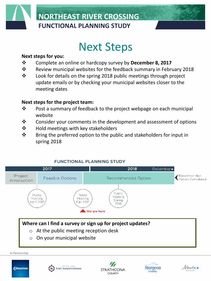
Next Steps
Where can I find a survey or sign up for project updates?o At the public meeting reception desko On your municipal website
Next steps for you: Complete an online or hardcopy survey by December 8, 2017 Review municipal websites for the feedback summary in February 2018 Look for details on the spring 2018 public meetings through project
update emails or by checking your municipal websites closer to the meeting dates
Next steps for the project team: Post a summary of feedback to the project webpage on each municipal
website Consider your comments in the development and assessment of options Hold meetings with key stakeholders Bring the preferred option to the public and stakeholders for input in
spring 2018

In Partnership
NORTHEAST RIVER CROSSINGFUNCTIONAL PLANNING STUDY
Your Comments are Important
Please write your comments on sticky notes and place on the large plans on the tables. Please provide your:
• concerns • ideas
OR
Markup the smaller maps and hand in to the reception desk
OR
Chat with one of our staff
THANK YOU


![[Normandy] Crossing of Elle river](https://img.pdfslide.net/doc/110x75/61688882d394e9041f705065/normandy-crossing-of-elle-river.jpg)

