Embed Size (px)
Citation preview
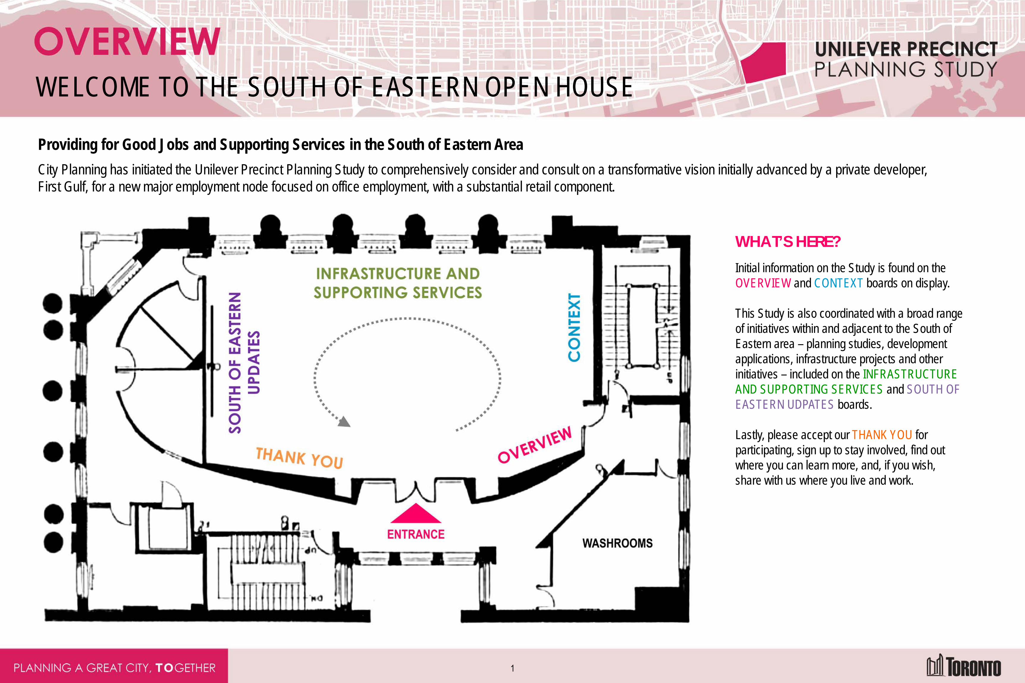
WELCOME TO THE SOUTH OF EASTERN OPEN HOUSE
Providing for Good Jobs and Supporting Services in the South of Eastern Area City Planning has initiated the Unilever Precinct Planning Study to comprehensively consider and consult on a transformative vision initially advanced by a private developer, First Gulf, for a new major employment node focused on office employment, with a substantial retail component.
WHAT’S HERE? Initial information on the Study is found on the OVERVIEW and CONTEXT boards on display. This Study is also coordinated with a broad range of initiatives within and adjacent to the South of Eastern area – planning studies, development applications, infrastructure projects and other initiatives – included on the INFRASTRUCTURE AND SUPPORTING SERVICES and SOUTH OF EASTERN UDPATES boards. Lastly, please accept our THANK YOU for participating, sign up to stay involved, find out where you can learn more, and, if you wish, share with us where you live and work.
1
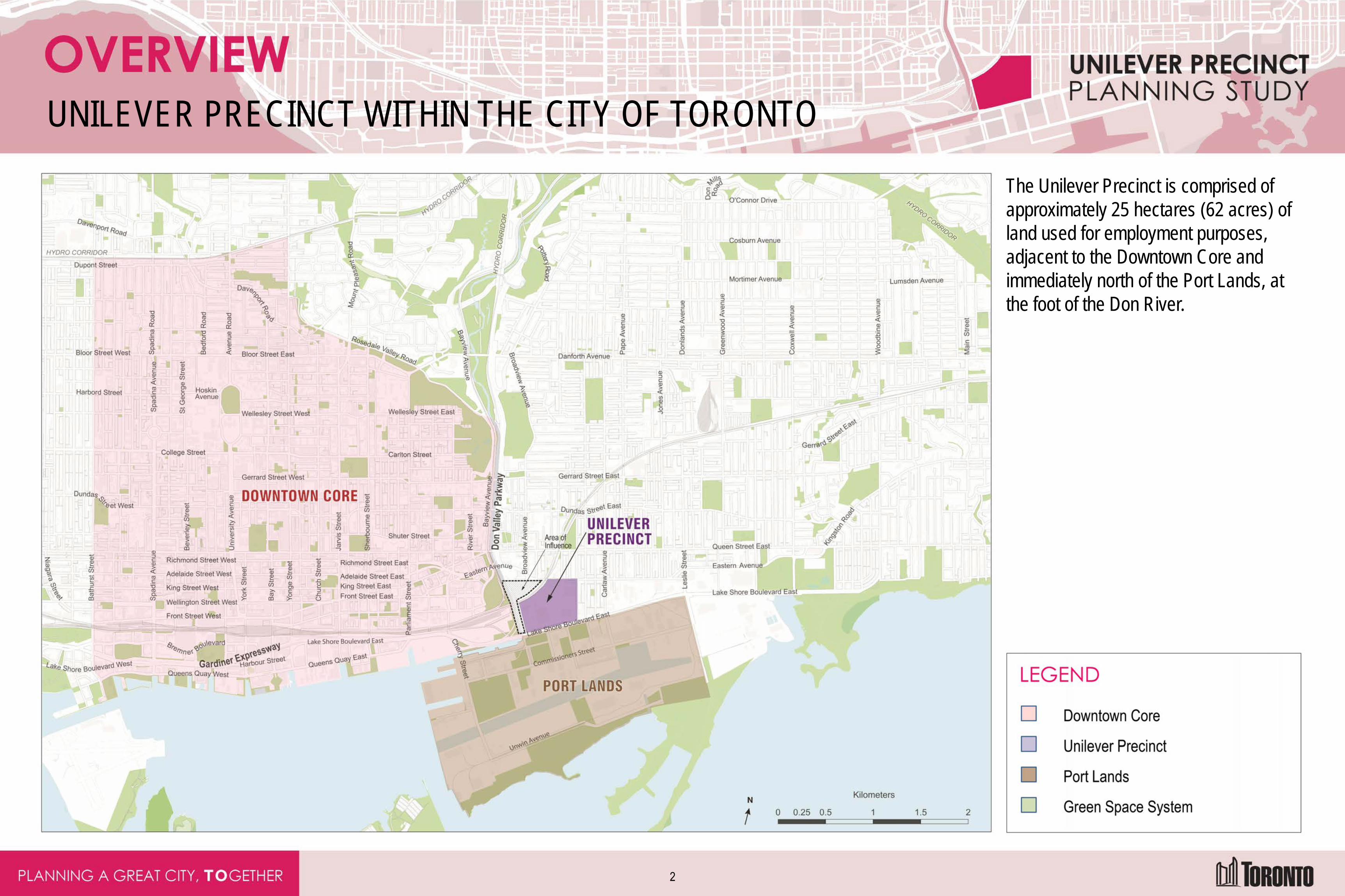
UNILEVER PRECINCT WITHIN THE CITY OF TORONTO
The Unilever Precinct is comprised of approximately 25 hectares (62 acres) of land used for employment purposes, adjacent to the Downtown Core and immediately north of the Port Lands, at the foot of the Don River.
2
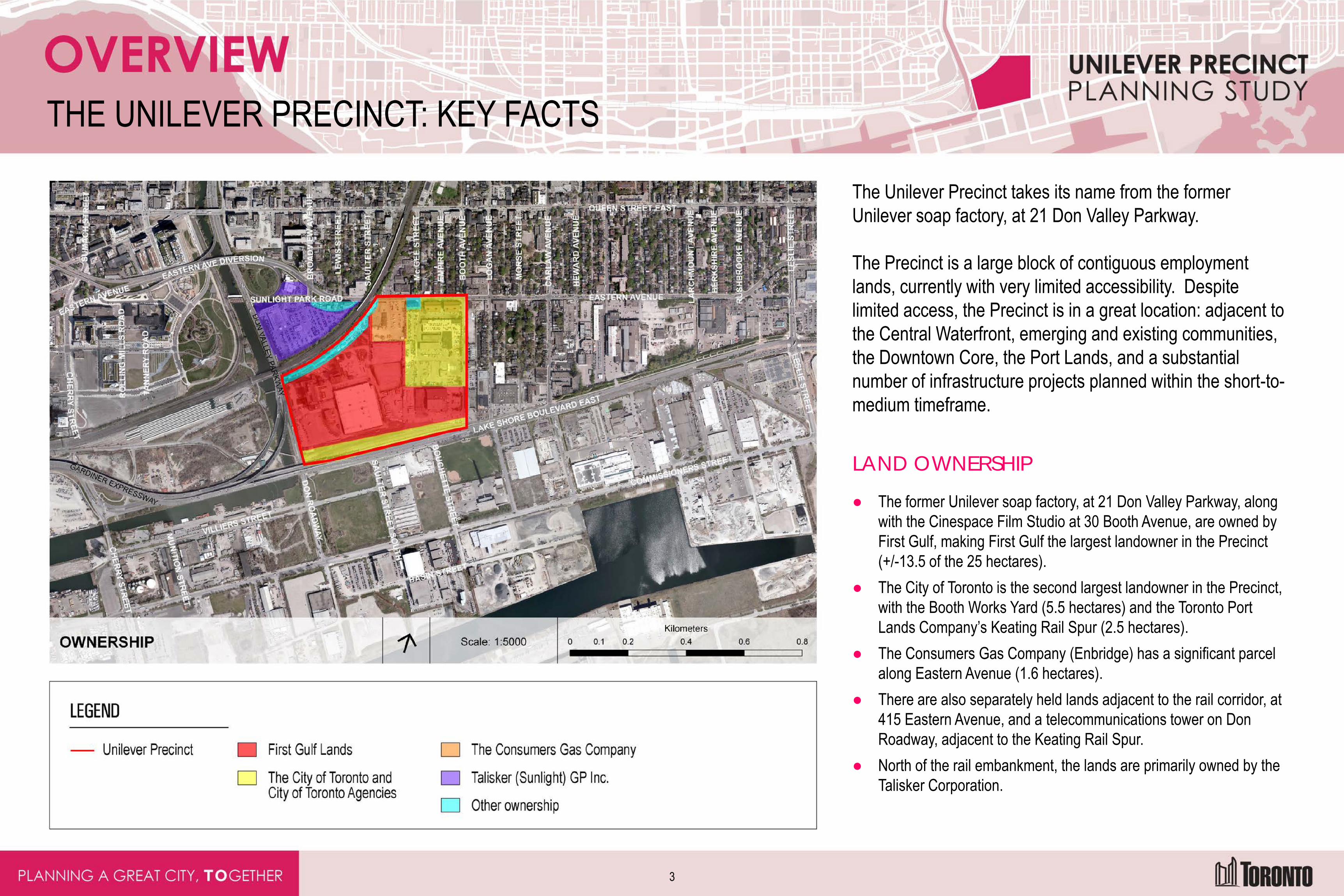
THE UNILEVER PRECINCT: KEY FACTS
The Unilever Precinct takes its name from the former Unilever soap factory, at 21 Don Valley Parkway. The Precinct is a large block of contiguous employment lands, currently with very limited accessibility. Despite limited access, the Precinct is in a great location: adjacent to the Central Waterfront, emerging and existing communities, the Downtown Core, the Port Lands, and a substantial number of infrastructure projects planned within the short-to-medium timeframe.
LAND OWNERSHIP
● The former Unilever soap factory, at 21 Don Valley Parkway, along with the Cinespace Film Studio at 30 Booth Avenue, are owned by First Gulf, making First Gulf the largest landowner in the Precinct (+/-13.5 of the 25 hectares).
● The City of Toronto is the second largest landowner in the Precinct, with the Booth Works Yard (5.5 hectares) and the Toronto Port Lands Company’s Keating Rail Spur (2.5 hectares).
● The Consumers Gas Company (Enbridge) has a significant parcel along Eastern Avenue (1.6 hectares).
● There are also separately held lands adjacent to the rail corridor, at 415 Eastern Avenue, and a telecommunications tower on Don Roadway, adjacent to the Keating Rail Spur.
● North of the rail embankment, the lands are primarily owned by the Talisker Corporation.
3
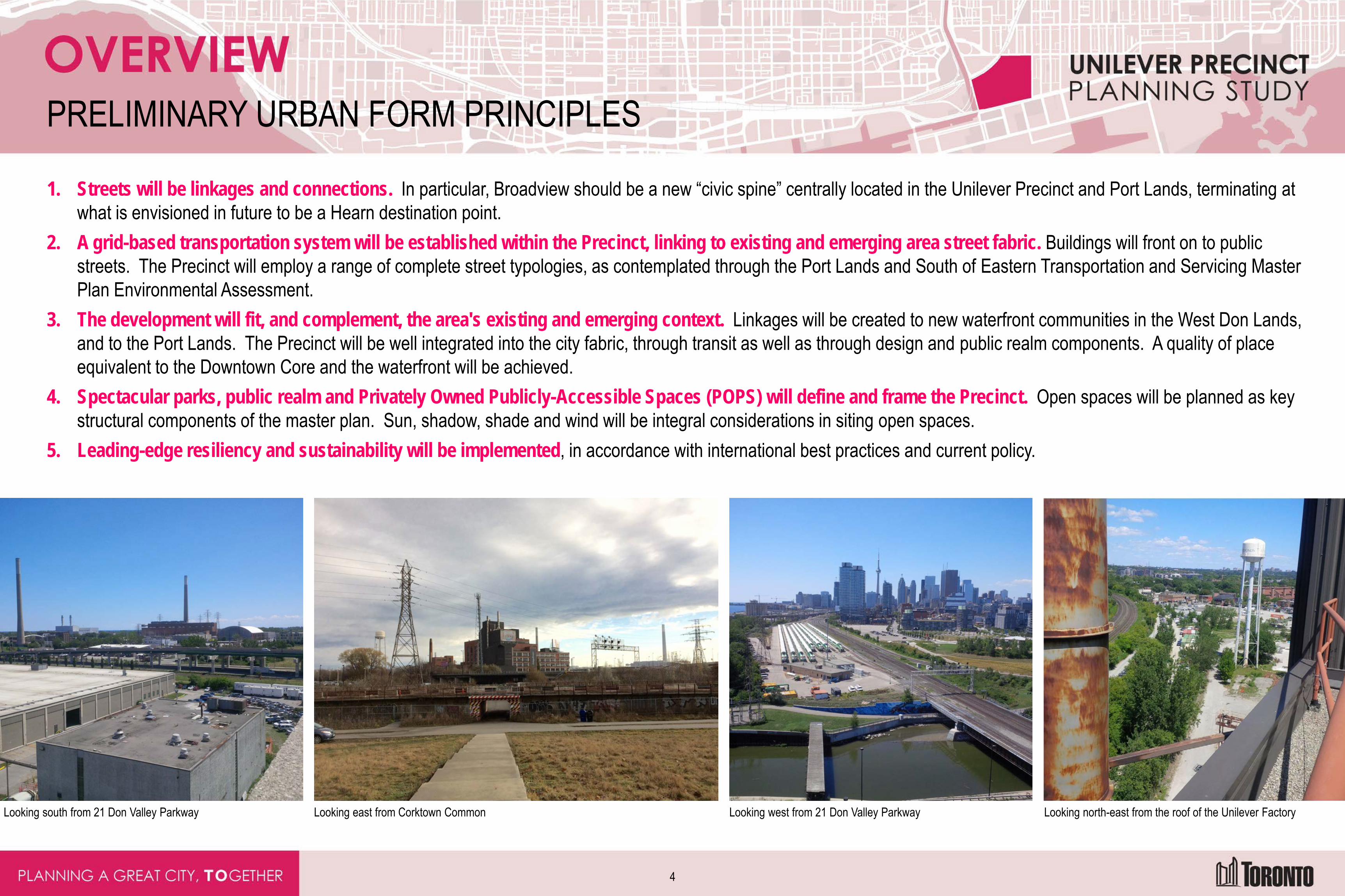
PRELIMINARY URBAN FORM PRINCIPLES
1. Streets will be linkages and connections. In particular, Broadview should be a new “civic spine” centrally located in the Unilever Precinct and Port Lands, terminating at what is envisioned in future to be a Hearn destination point.
2. A grid-based transportation system will be established within the Precinct, linking to existing and emerging area street fabric. Buildings will front on to public streets. The Precinct will employ a range of complete street typologies, as contemplated through the Port Lands and South of Eastern Transportation and Servicing Master Plan Environmental Assessment.
3. The development will fit, and complement, the area's existing and emerging context. Linkages will be created to new waterfront communities in the West Don Lands, and to the Port Lands. The Precinct will be well integrated into the city fabric, through transit as well as through design and public realm components. A quality of place equivalent to the Downtown Core and the waterfront will be achieved.
4. Spectacular parks, public realm and Privately Owned Publicly-Accessible Spaces (POPS) will define and frame the Precinct. Open spaces will be planned as key structural components of the master plan. Sun, shadow, shade and wind will be integral considerations in siting open spaces.
5. Leading-edge resiliency and sustainability will be implemented, in accordance with international best practices and current policy.
Looking south from 21 Don Valley Parkway Looking east from Corktown Common Looking west from 21 Don Valley Parkway Looking north-east from the roof of the Unilever Factory
4
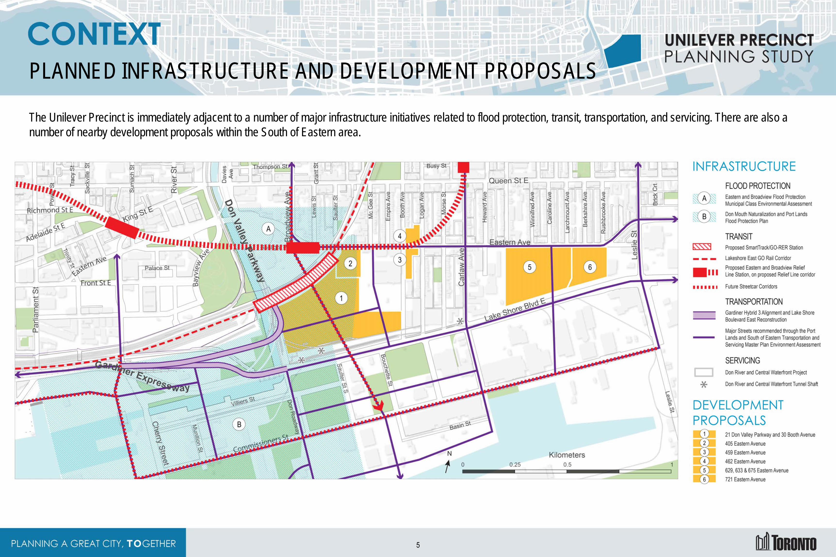
PLANNED INFRASTRUCTURE AND DEVELOPMENT PROPOSALS
The Unilever Precinct is immediately adjacent to a number of major infrastructure initiatives related to flood protection, transit, transportation, and servicing. There are also a number of nearby development proposals within the South of Eastern area.
5
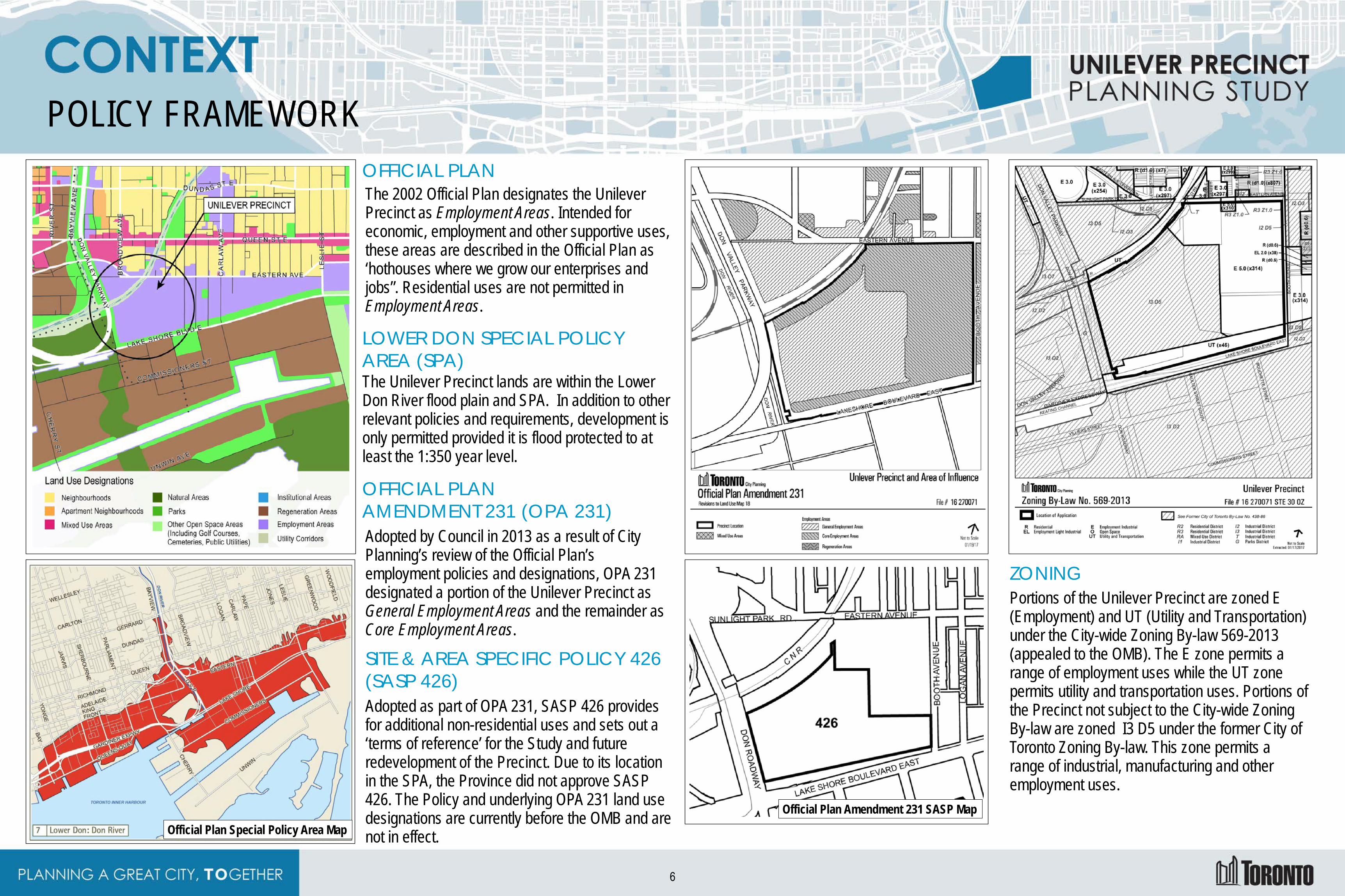
POLICY FRAMEWORK OFFICIAL PLAN The 2002 Official Plan designates the Unilever Precinct as Employment Areas. Intended for economic, employment and other supportive uses, these areas are described in the Official Plan as ‘hothouses where we grow our enterprises and jobs”. Residential uses are not permitted in Employment Areas.
LOWER DON SPECIAL POLICY AREA (SPA) The Unilever Precinct lands are within the Lower Don River flood plain and SPA. In addition to other relevant policies and requirements, development is only permitted provided it is flood protected to at least the 1:350 year level.
OFFICIAL PLAN AMENDMENT 231 (OPA 231) Adopted by Council in 2013 as a result of City Planning’s review of the Official Plan’s employment policies and designations, OPA 231 designated a portion of the Unilever Precinct as General Employment Areas and the remainder as Core Employment Areas.
SITE & AREA SPECIFIC POLICY 426 (SASP 426) Adopted as part of OPA 231, SASP 426 provides for additional non-residential uses and sets out a ‘terms of reference’ for the Study and future redevelopment of the Precinct. Due to its location in the SPA, the Province did not approve SASP 426. The Policy and underlying OPA 231 land use designations are currently before the OMB and are not in effect.
ZONING Portions of the Unilever Precinct are zoned E (Employment) and UT (Utility and Transportation) under the City-wide Zoning By-law 569-2013 (appealed to the OMB). The E zone permits a range of employment uses while the UT zone permits utility and transportation uses. Portions of the Precinct not subject to the City-wide Zoning By-law are zoned I3 D5 under the former City of Toronto Zoning By-law. This zone permits a range of industrial, manufacturing and other employment uses.
Official Plan Special Policy Area Map Official Plan Amendment 231 SASP Map
6
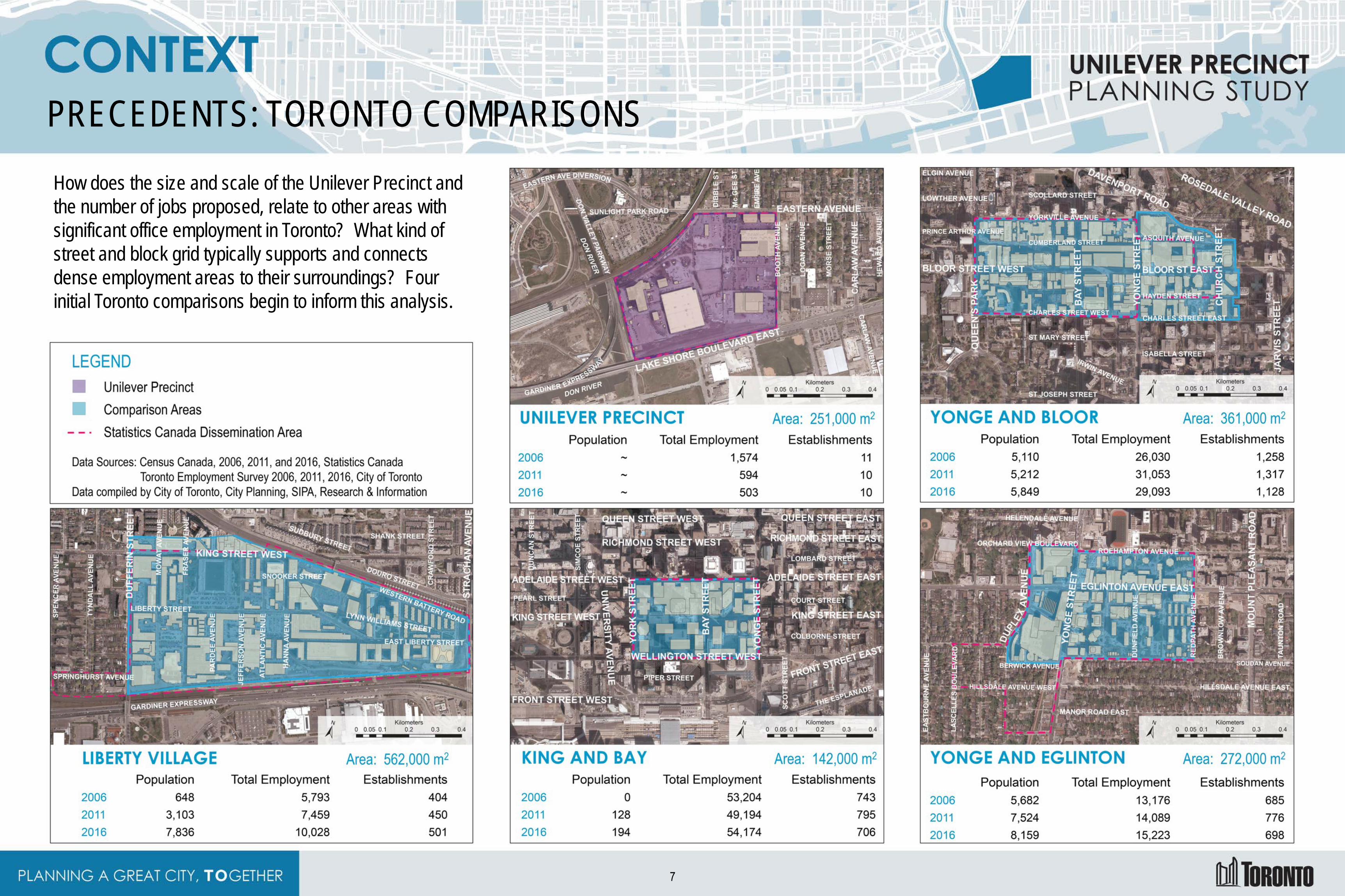
PRECEDENTS: TORONTO COMPARISONS How does the size and scale of the Unilever Precinct and the number of jobs proposed, relate to other areas with significant office employment in Toronto? What kind of street and block grid typically supports and connects dense employment areas to their surroundings? Four initial Toronto comparisons begin to inform this analysis.
7
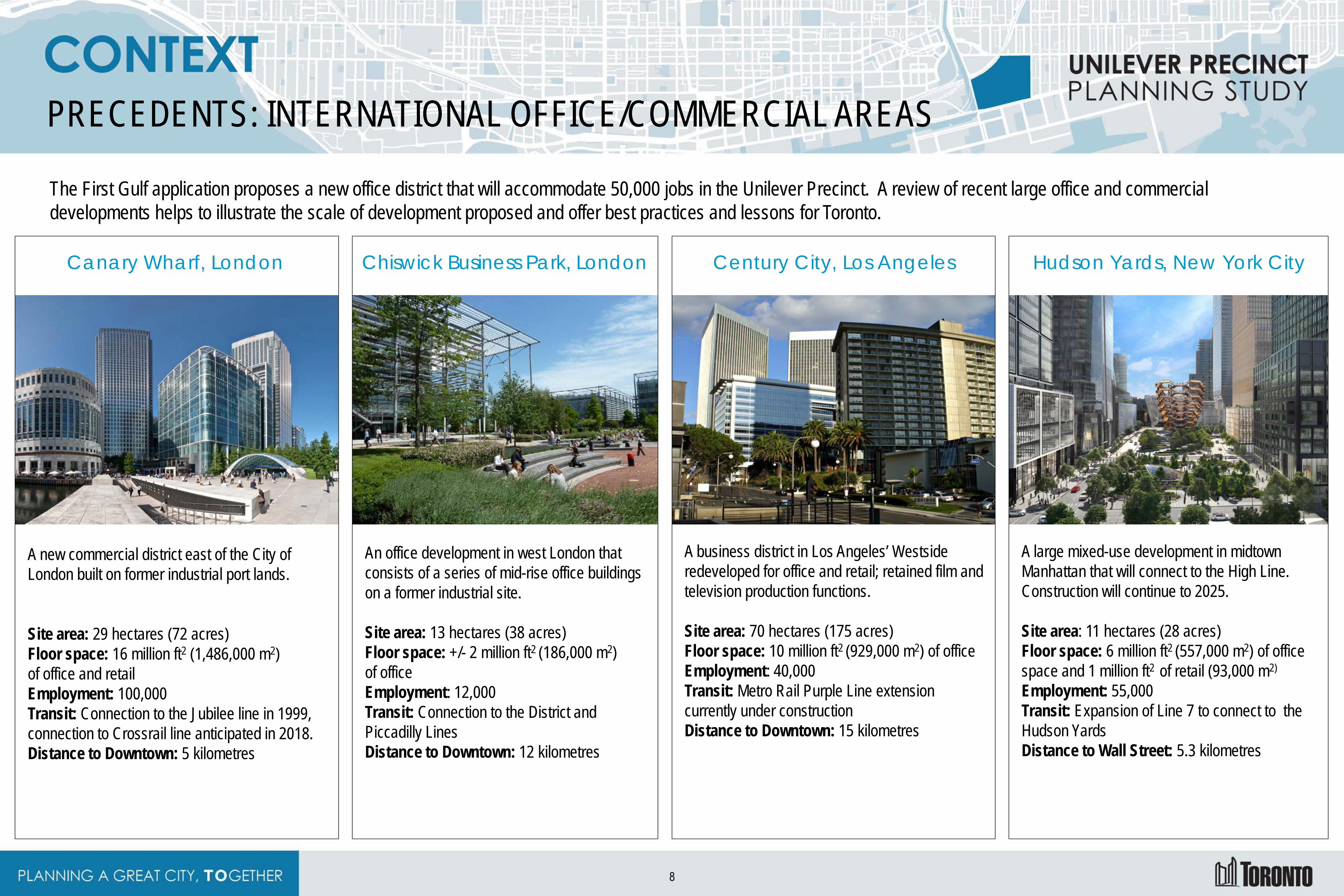
PRECEDENTS: INTERNATIONAL OFFICE/COMMERCIAL AREAS
The First Gulf application proposes a new office district that will accommodate 50,000 jobs in the Unilever Precinct. A review of recent large office and commercial developments helps to illustrate the scale of development proposed and offer best practices and lessons for Toronto.
Canary Wharf, London
A new commercial district east of the City of London built on former industrial port lands. Site area: 29 hectares (72 acres) Floor space: 16 million ft2 (1,486,000 m2) of office and retail Employment: 100,000 Transit: Connection to the Jubilee line in 1999, connection to Crossrail line anticipated in 2018. Distance to Downtown: 5 kilometres
Chiswick Business Park, London
An office development in west London that consists of a series of mid-rise office buildings on a former industrial site. Site area: 13 hectares (38 acres) Floor space: +/- 2 million ft2 (186,000 m2) of office Employment: 12,000 Transit: Connection to the District and Piccadilly Lines Distance to Downtown: 12 kilometres
Century City, Los Angeles
A business district in Los Angeles’ Westside redeveloped for office and retail; retained film and television production functions. Site area: 70 hectares (175 acres) Floor space: 10 million ft2 (929,000 m2) of office Employment: 40,000 Transit: Metro Rail Purple Line extension currently under construction Distance to Downtown: 15 kilometres
Hudson Yards, New York City
A large mixed-use development in midtown Manhattan that will connect to the High Line. Construction will continue to 2025. Site area: 11 hectares (28 acres) Floor space: 6 million ft2 (557,000 m2) of office space and 1 million ft2 of retail (93,000 m2) Employment: 55,000 Transit: Expansion of Line 7 to connect to the Hudson Yards Distance to Wall Street: 5.3 kilometres
8
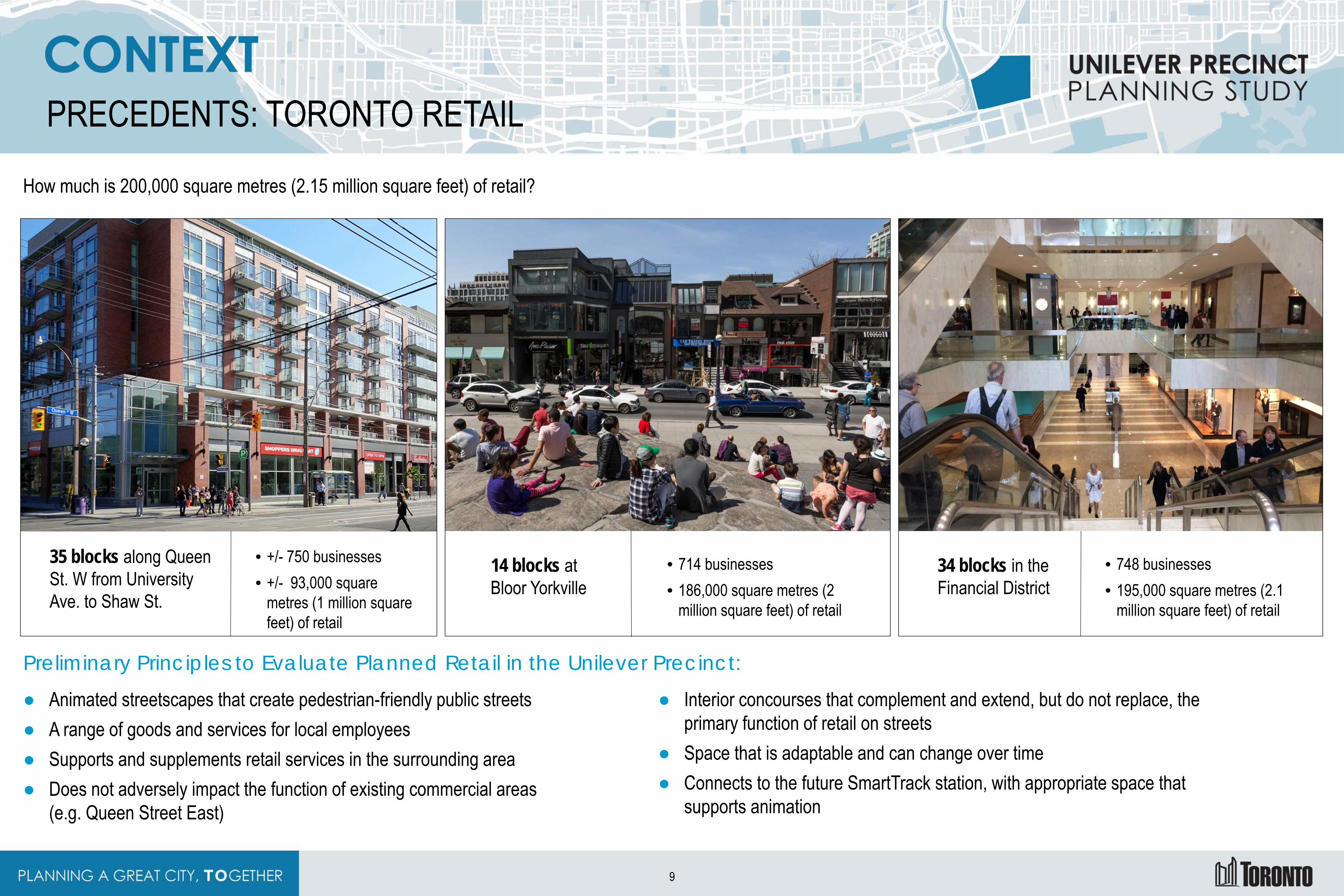
PRECEDENTS: TORONTO RETAIL
How much is 200,000 square metres (2.15 million square feet) of retail?
35 blocks along Queen St. W from University Ave. to Shaw St.
• +/- 750 businesses • +/- 93,000 square
metres (1 million square feet) of retail
14 blocks at Bloor Yorkville
• 714 businesses • 186,000 square metres (2
million square feet) of retail
34 blocks in the Financial District
• 748 businesses • 195,000 square metres (2.1
million square feet) of retail
Preliminary Principles to Evaluate Planned Retail in the Unilever Precinct:
● Animated streetscapes that create pedestrian-friendly public streets ● A range of goods and services for local employees ● Supports and supplements retail services in the surrounding area ● Does not adversely impact the function of existing commercial areas
(e.g. Queen Street East)
● Interior concourses that complement and extend, but do not replace, the primary function of retail on streets
● Space that is adaptable and can change over time ● Connects to the future SmartTrack station, with appropriate space that
supports animation
9
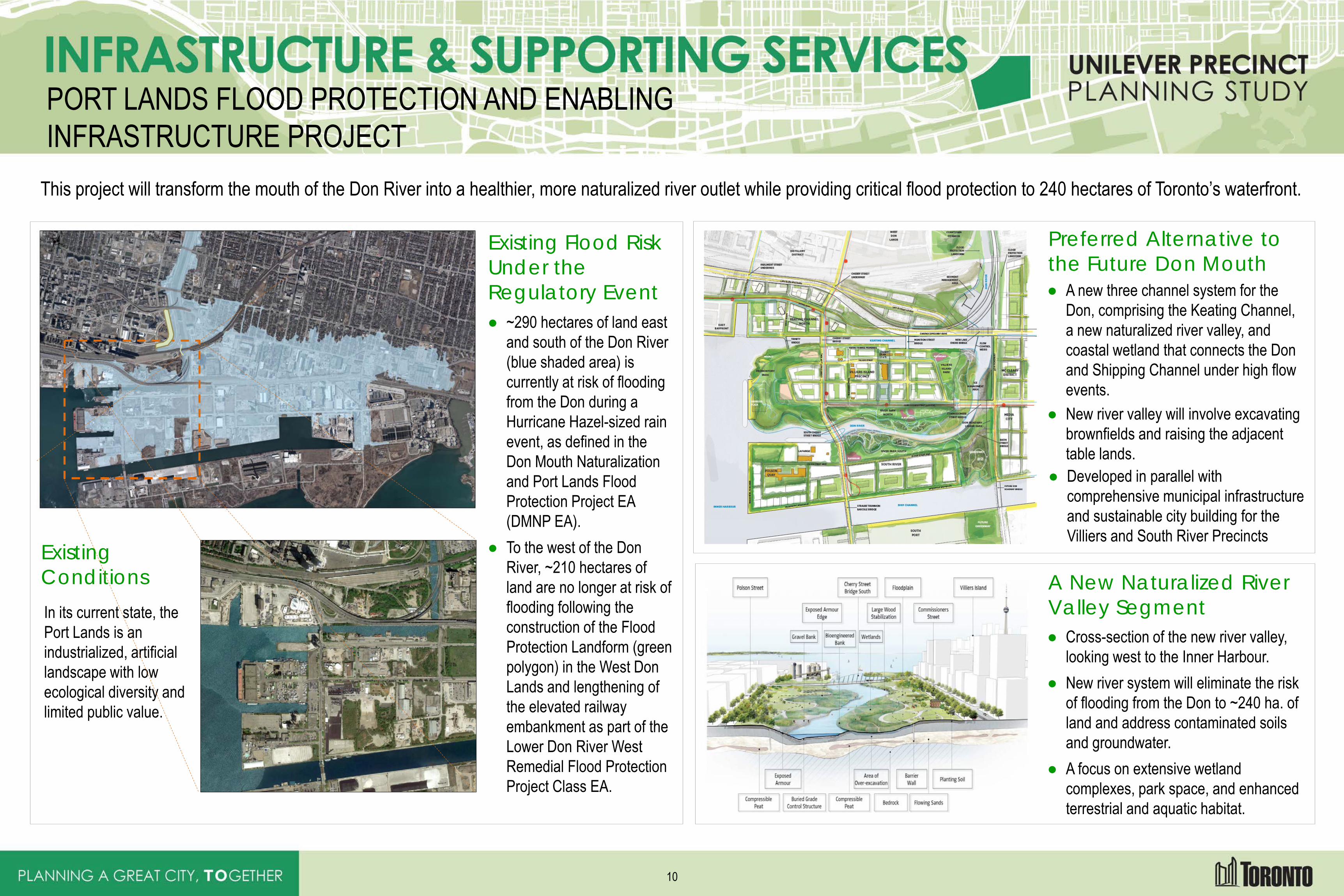
PORT LANDS FLOOD PROTECTION AND ENABLING INFRASTRUCTURE PROJECT
This project will transform the mouth of the Don River into a healthier, more naturalized river outlet while providing critical flood protection to 240 hectares of Toronto’s waterfront.
Existing Conditions In its current state, the Port Lands is an industrialized, artificial landscape with low ecological diversity and limited public value.
Existing Flood Risk Under the Regulatory Event ● ~290 hectares of land east
and south of the Don River (blue shaded area) is currently at risk of flooding from the Don during a Hurricane Hazel-sized rain event, as defined in the Don Mouth Naturalization and Port Lands Flood Protection Project EA (DMNP EA).
● To the west of the Don River, ~210 hectares of land are no longer at risk of flooding following the construction of the Flood Protection Landform (green polygon) in the West Don Lands and lengthening of the elevated railway embankment as part of the Lower Don River West Remedial Flood Protection Project Class EA.
Preferred Alternative to the Future Don Mouth ● A new three channel system for the
Don, comprising the Keating Channel, a new naturalized river valley, and coastal wetland that connects the Don and Shipping Channel under high flow events.
● New river valley will involve excavating brownfields and raising the adjacent table lands.
● Developed in parallel with comprehensive municipal infrastructure and sustainable city building for the Villiers and South River Precincts
A New Naturalized River Valley Segment ● Cross-section of the new river valley,
looking west to the Inner Harbour. ● New river system will eliminate the risk
of flooding from the Don to ~240 ha. of land and address contaminated soils and groundwater.
● A focus on extensive wetland complexes, park space, and enhanced terrestrial and aquatic habitat.
10
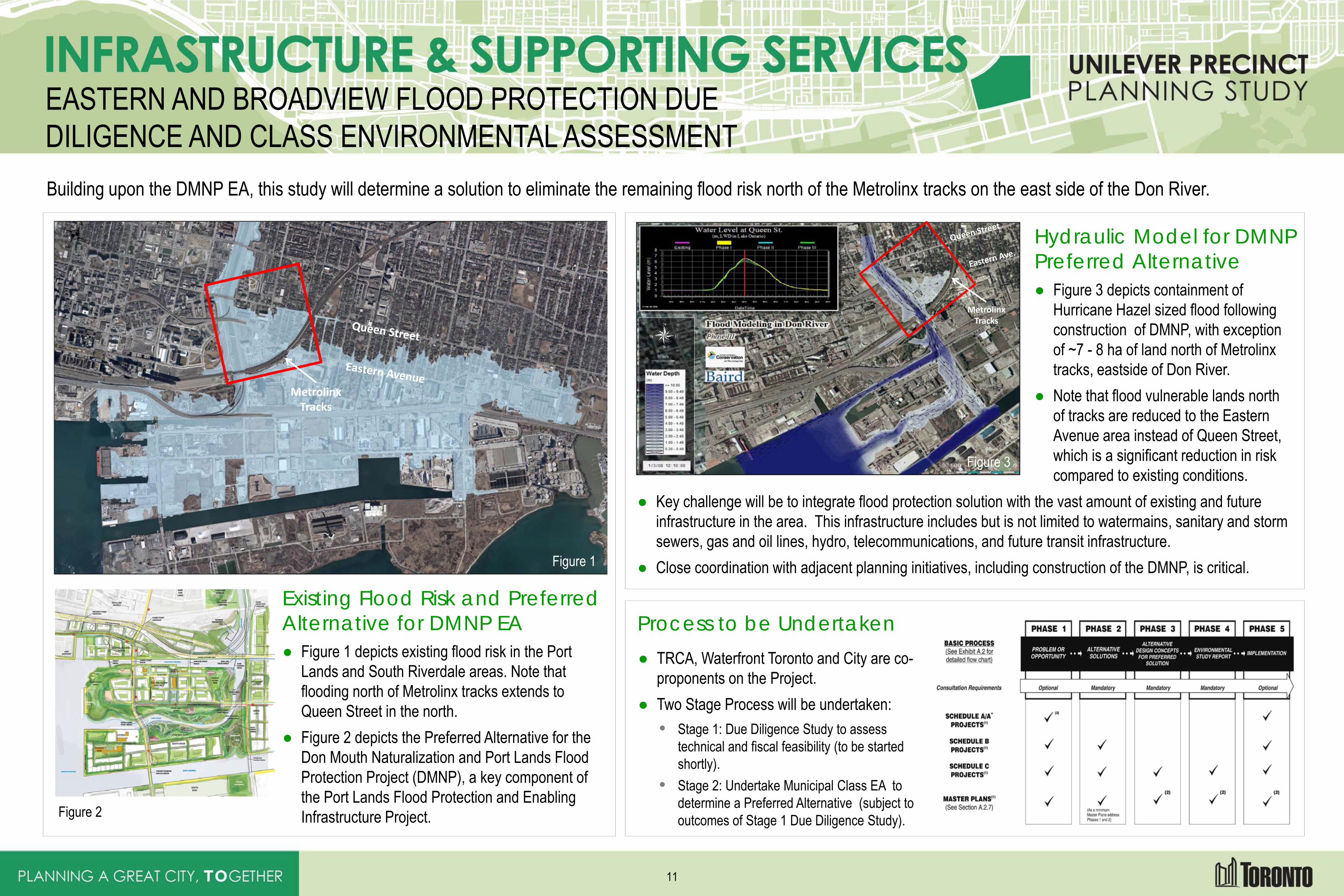
EASTERN AND BROADVIEW FLOOD PROTECTION DUE DILIGENCE AND CLASS ENVIRONMENTAL ASSESSMENT Building upon the DMNP EA, this study will determine a solution to eliminate the remaining flood risk north of the Metrolinx tracks on the east side of the Don River.
Existing Flood Risk and Preferred Alternative for DMNP EA ● Figure 1 depicts existing flood risk in the Port
Lands and South Riverdale areas. Note that flooding north of Metrolinx tracks extends to Queen Street in the north.
● Figure 2 depicts the Preferred Alternative for the Don Mouth Naturalization and Port Lands Flood Protection Project (DMNP), a key component of the Port Lands Flood Protection and Enabling Infrastructure Project.
Hydraulic Model for DMNP Preferred Alternative ● Figure 3 depicts containment of
Hurricane Hazel sized flood following construction of DMNP, with exception of ~7 - 8 ha of land north of Metrolinx tracks, eastside of Don River.
● Note that flood vulnerable lands north of tracks are reduced to the Eastern Avenue area instead of Queen Street, which is a significant reduction in risk compared to existing conditions.
● Key challenge will be to integrate flood protection solution with the vast amount of existing and future infrastructure in the area. This infrastructure includes but is not limited to watermains, sanitary and storm sewers, gas and oil lines, hydro, telecommunications, and future transit infrastructure.
● Close coordination with adjacent planning initiatives, including construction of the DMNP, is critical.
Process to be Undertaken ● TRCA, Waterfront Toronto and City are co-
proponents on the Project. ● Two Stage Process will be undertaken:
• Stage 1: Due Diligence Study to assess technical and fiscal feasibility (to be started shortly).
• Stage 2: Undertake Municipal Class EA to determine a Preferred Alternative (subject to outcomes of Stage 1 Due Diligence Study).
Metrolinx Tracks
Metrolinx Tracks
Figure 2
Figure 1
Figure 3
11
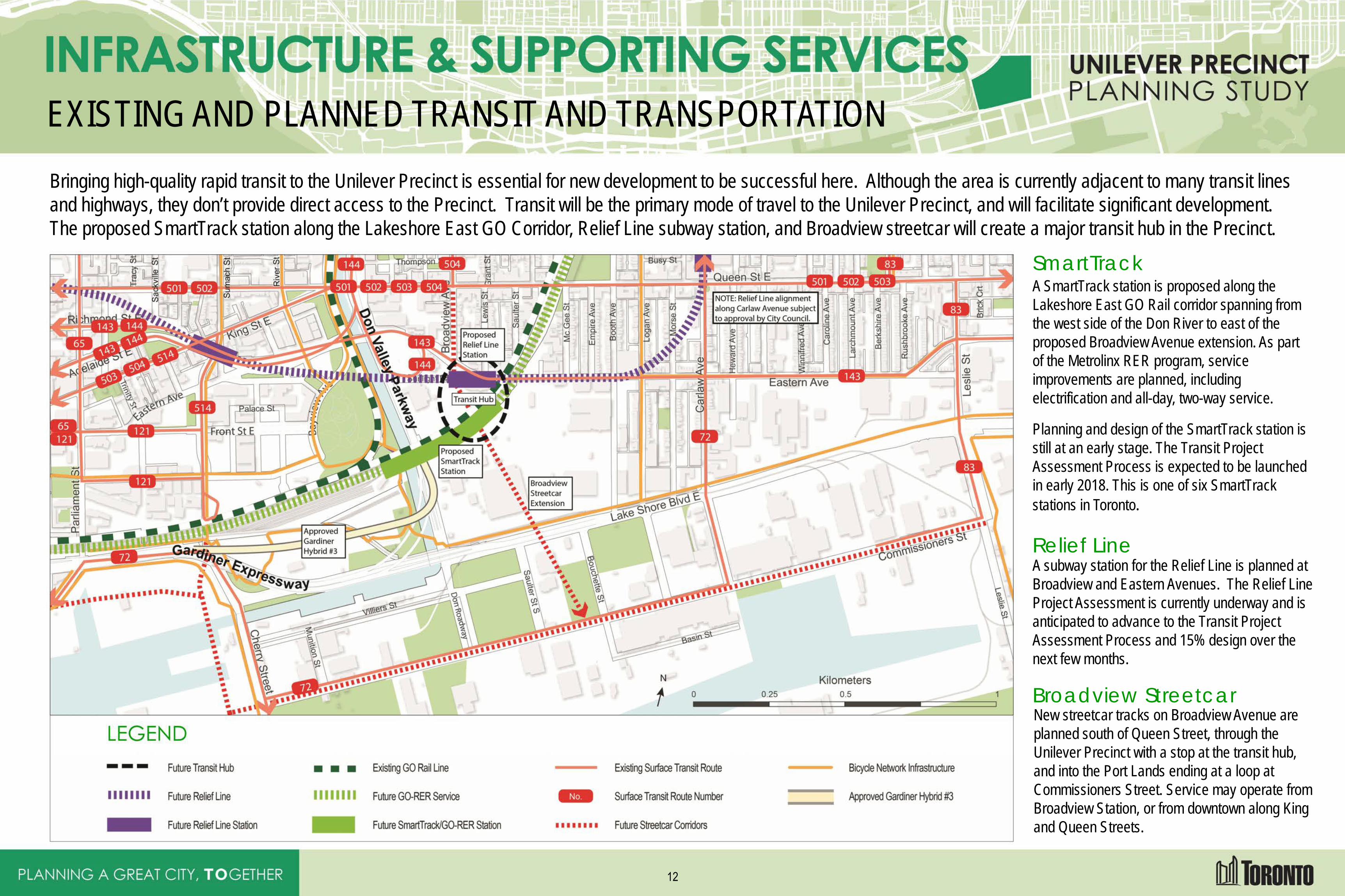
EXISTING AND PLANNED TRANSIT AND TRANSPORTATION Bringing high-quality rapid transit to the Unilever Precinct is essential for new development to be successful here. Although the area is currently adjacent to many transit lines and highways, they don’t provide direct access to the Precinct. Transit will be the primary mode of travel to the Unilever Precinct, and will facilitate significant development. The proposed SmartTrack station along the Lakeshore East GO Corridor, Relief Line subway station, and Broadview streetcar will create a major transit hub in the Precinct.
SmartTrack A SmartTrack station is proposed along the Lakeshore East GO Rail corridor spanning from the west side of the Don River to east of the proposed Broadview Avenue extension. As part of the Metrolinx RER program, service improvements are planned, including electrification and all-day, two-way service.
Planning and design of the SmartTrack station is still at an early stage. The Transit Project Assessment Process is expected to be launched in early 2018. This is one of six SmartTrack stations in Toronto.
Relief Line A subway station for the Relief Line is planned at Broadview and Eastern Avenues. The Relief Line Project Assessment is currently underway and is anticipated to advance to the Transit Project Assessment Process and 15% design over the next few months.
Broadview Streetcar New streetcar tracks on Broadview Avenue are planned south of Queen Street, through the Unilever Precinct with a stop at the transit hub, and into the Port Lands ending at a loop at Commissioners Street. Service may operate from Broadview Station, or from downtown along King and Queen Streets.
12
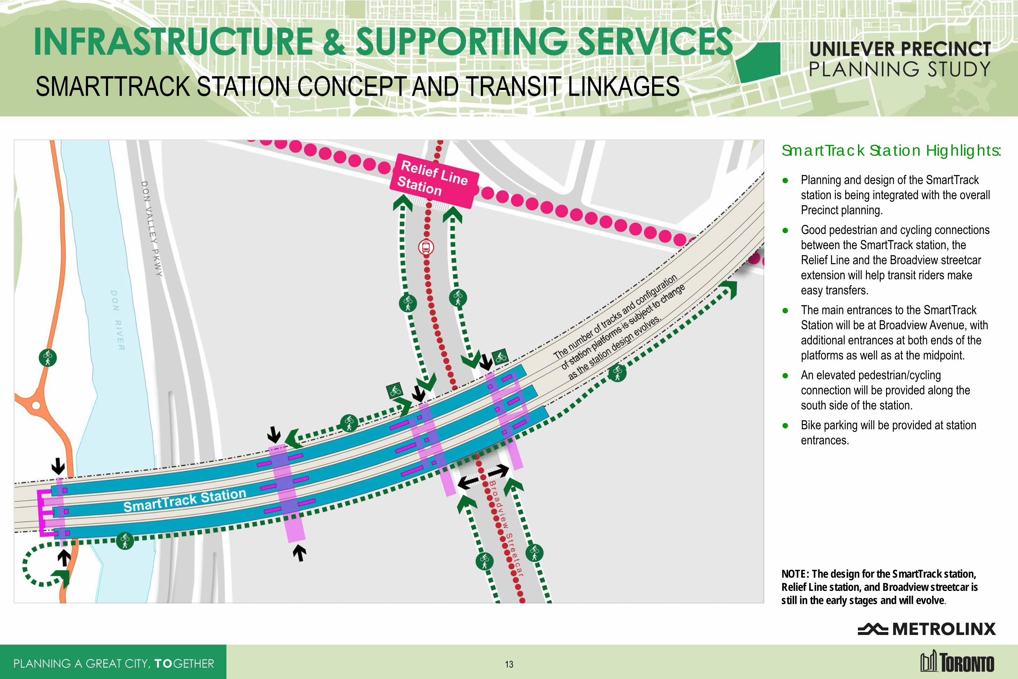
SMARTTRACK STATION CONCEPT AND TRANSIT LINKAGES
SmartTrack Station Highlights:
● Planning and design of the SmartTrack station is being integrated with the overall Precinct planning.
● Good pedestrian and cycling connections between the SmartTrack station, the Relief Line and the Broadview streetcar extension will help transit riders make easy transfers.
● The main entrances to the SmartTrack Station will be at Broadview Avenue, with additional entrances at both ends of the platforms as well as at the midpoint.
● An elevated pedestrian/cycling connection will be provided along the south side of the station.
● Bike parking will be provided at station entrances.
NOTE: The design for the SmartTrack station, Relief Line station, and Broadview streetcar is still in the early stages and will evolve.
13
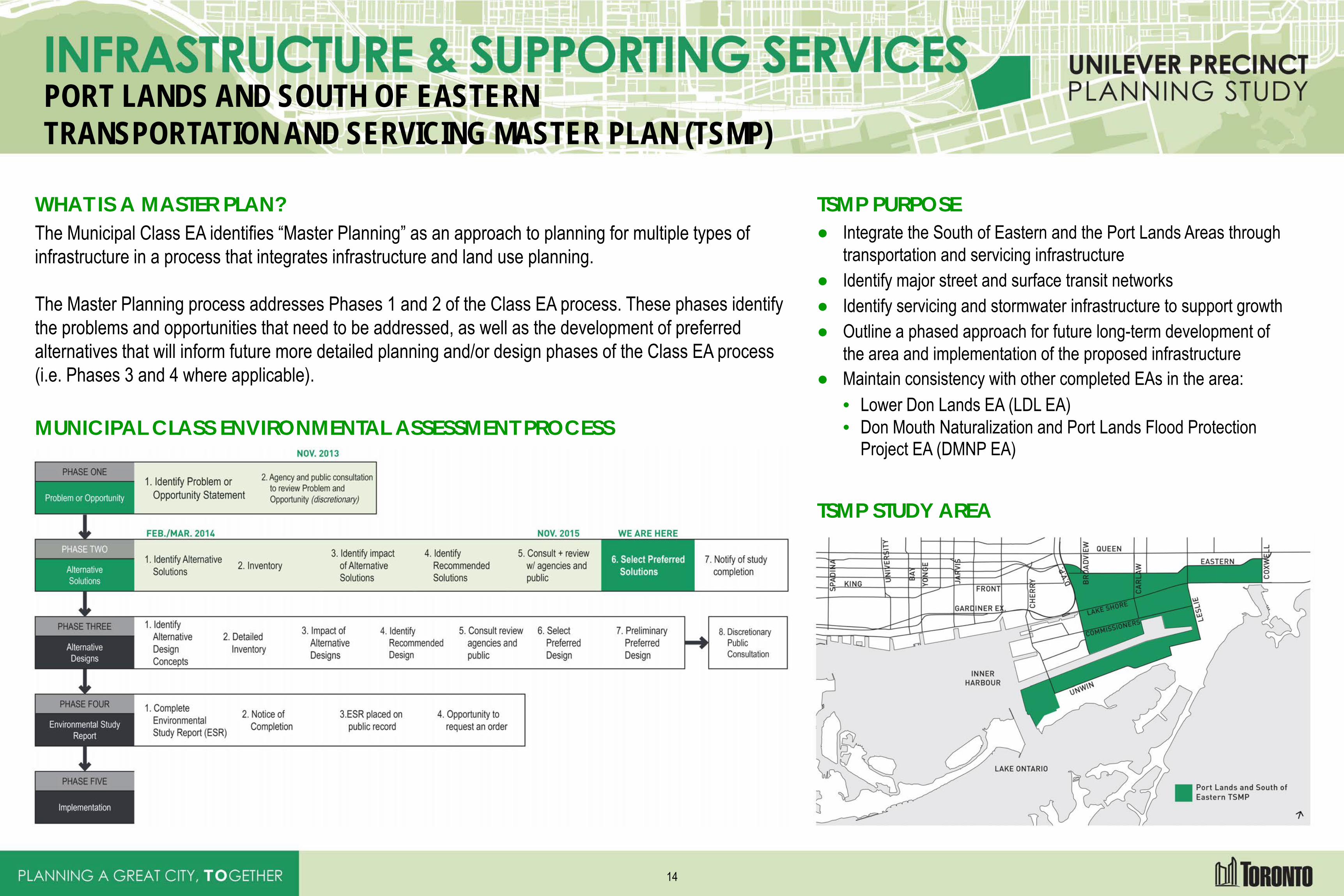
PORT LANDS AND SOUTH OF EASTERN TRANSPORTATION AND SERVICING MASTER PLAN (TSMP)
WHAT IS A MASTER PLAN? The Municipal Class EA identifies “Master Planning” as an approach to planning for multiple types of infrastructure in a process that integrates infrastructure and land use planning. The Master Planning process addresses Phases 1 and 2 of the Class EA process. These phases identify the problems and opportunities that need to be addressed, as well as the development of preferred alternatives that will inform future more detailed planning and/or design phases of the Class EA process (i.e. Phases 3 and 4 where applicable).
MUNICIPAL CLASS ENVIRONMENTAL ASSESSMENT PROCESS
TSMP PURPOSE ● Integrate the South of Eastern and the Port Lands Areas through
transportation and servicing infrastructure ● Identify major street and surface transit networks ● Identify servicing and stormwater infrastructure to support growth ● Outline a phased approach for future long-term development of
the area and implementation of the proposed infrastructure ● Maintain consistency with other completed EAs in the area:
• Lower Don Lands EA (LDL EA) • Don Mouth Naturalization and Port Lands Flood Protection
Project EA (DMNP EA)
TSMP STUDY AREA
14
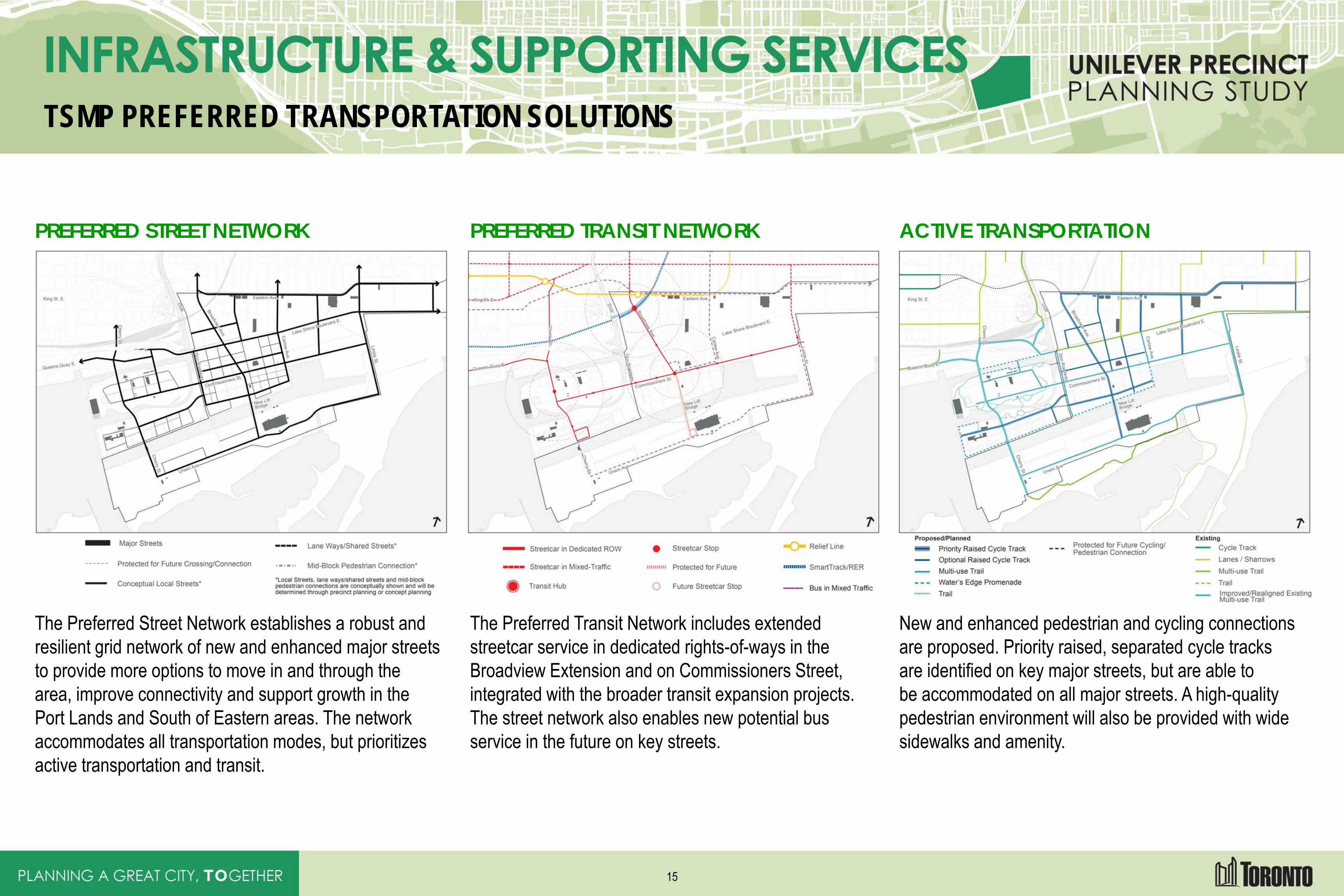
TSMP PREFERRED TRANSPORTATION SOLUTIONS
PREFERRED STREET NETWORK
The Preferred Street Network establishes a robust and resilient grid network of new and enhanced major streets to provide more options to move in and through the area, improve connectivity and support growth in the Port Lands and South of Eastern areas. The network accommodates all transportation modes, but prioritizes active transportation and transit.
PREFERRED TRANSIT NETWORK
The Preferred Transit Network includes extended streetcar service in dedicated rights-of-ways in the Broadview Extension and on Commissioners Street, integrated with the broader transit expansion projects. The street network also enables new potential bus service in the future on key streets.
ACTIVE TRANSPORTATION
New and enhanced pedestrian and cycling connections are proposed. Priority raised, separated cycle tracks are identified on key major streets, but are able to be accommodated on all major streets. A high-quality pedestrian environment will also be provided with wide sidewalks and amenity.
15
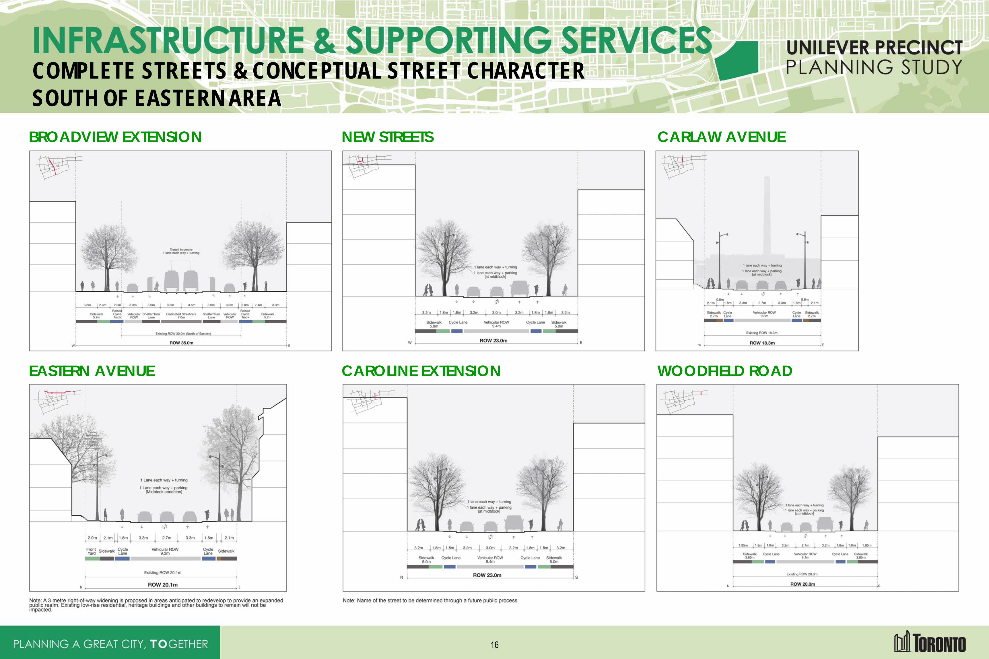
COMPLETE STREETS & CONCEPTUAL STREET CHARACTER SOUTH OF EASTERN AREA BROADVIEW EXTENSION NEW STREETS CARLAW AVENUE
EASTERN AVENUE CAROLINE EXTENSION WOODFIELD ROAD
16
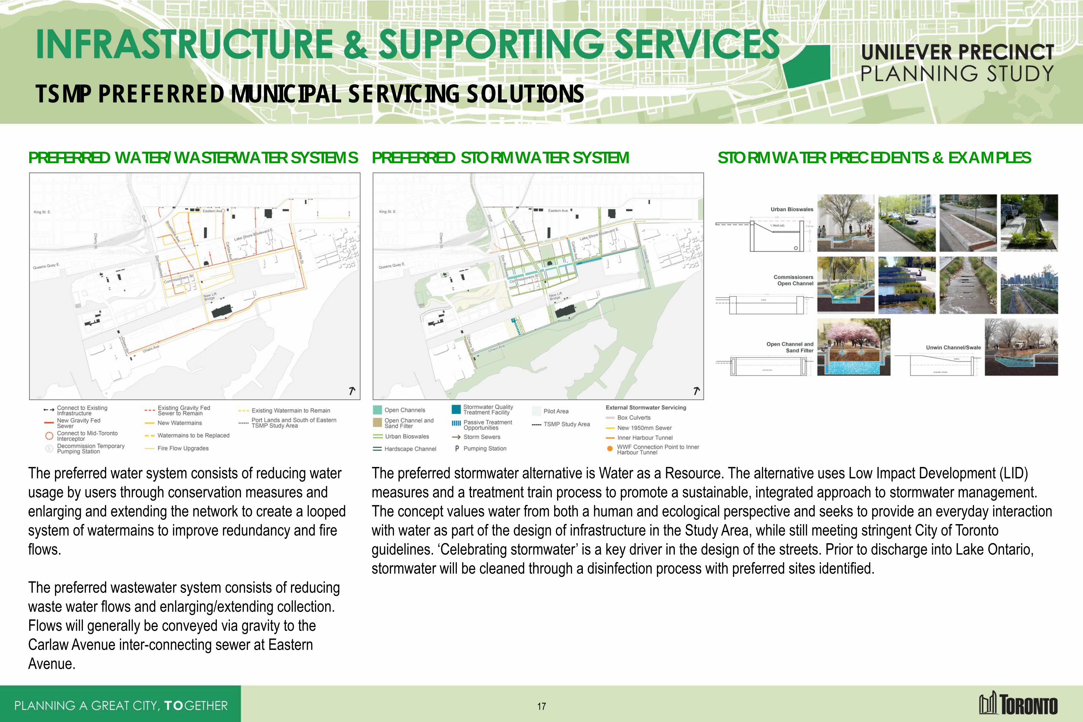
TSMP PREFERRED MUNICIPAL SERVICING SOLUTIONS
PREFERRED WATER/WASTERWATER SYSTEMS
The preferred water system consists of reducing water usage by users through conservation measures and enlarging and extending the network to create a looped system of watermains to improve redundancy and fire flows. The preferred wastewater system consists of reducing waste water flows and enlarging/extending collection. Flows will generally be conveyed via gravity to the Carlaw Avenue inter-connecting sewer at Eastern Avenue.
PREFERRED STORMWATER SYSTEM STORMWATER PRECEDENTS & EXAMPLES
The preferred stormwater alternative is Water as a Resource. The alternative uses Low Impact Development (LID) measures and a treatment train process to promote a sustainable, integrated approach to stormwater management. The concept values water from both a human and ecological perspective and seeks to provide an everyday interaction with water as part of the design of infrastructure in the Study Area, while still meeting stringent City of Toronto guidelines. ‘Celebrating stormwater’ is a key driver in the design of the streets. Prior to discharge into Lake Ontario, stormwater will be cleaned through a disinfection process with preferred sites identified.
17
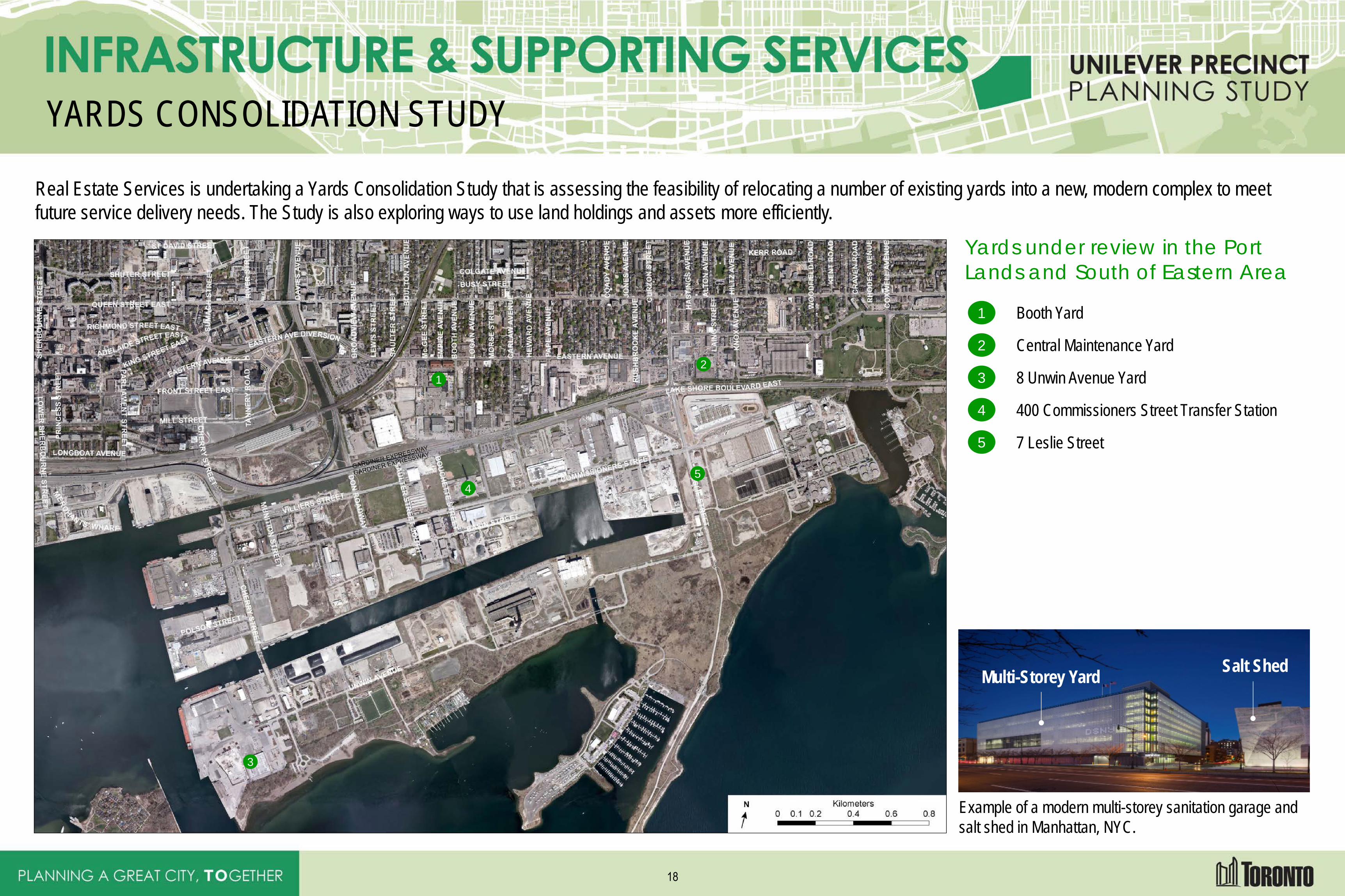
YARDS CONSOLIDATION STUDY
Real Estate Services is undertaking a Yards Consolidation Study that is assessing the feasibility of relocating a number of existing yards into a new, modern complex to meet future service delivery needs. The Study is also exploring ways to use land holdings and assets more efficiently.
Yards under review in the Port Lands and South of Eastern Area
1
Booth Yard
2
Central Maintenance Yard
3
8 Unwin Avenue Yard
4 5
400 Commissioners Street Transfer Station
5 5
7 Leslie Street
Example of a modern multi-storey sanitation garage and salt shed in Manhattan, NYC.
Multi-Storey Yard Salt Shed
1
2
3
4 5
18
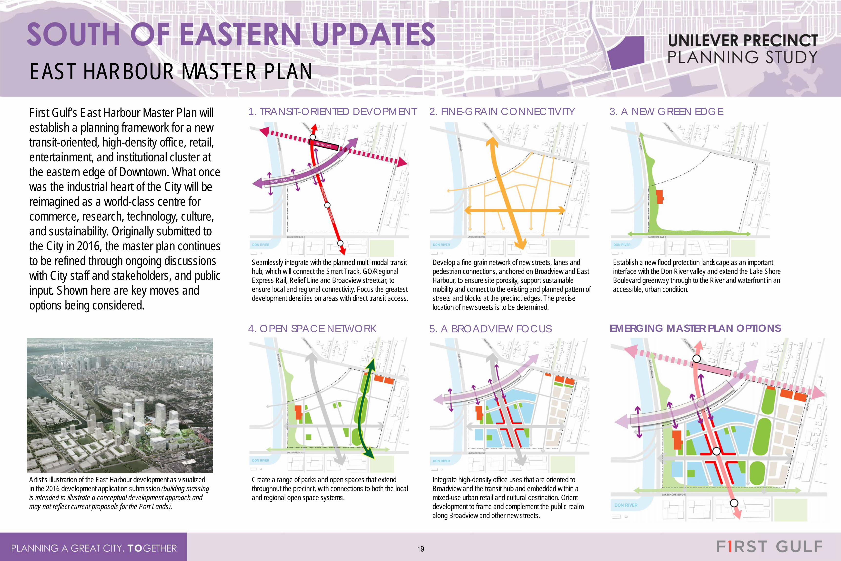
EAST HARBOUR MASTER PLAN First Gulf’s East Harbour Master Plan will establish a planning framework for a new transit-oriented, high-density office, retail, entertainment, and institutional cluster at the eastern edge of Downtown. What once was the industrial heart of the City will be reimagined as a world-class centre for commerce, research, technology, culture, and sustainability. Originally submitted to the City in 2016, the master plan continues to be refined through ongoing discussions with City staff and stakeholders, and public input. Shown here are key moves and options being considered.
Artist’s illustration of the East Harbour development as visualized in the 2016 development application submission (building massing is intended to illustrate a conceptual development approach and may not reflect current proposals for the Port Lands).
1. TRANSIT-ORIENTED DEVOPMENT
Seamlessly integrate with the planned multi-modal transit hub, which will connect the Smart Track, GO/Regional Express Rail, Relief Line and Broadview streetcar, to ensure local and regional connectivity. Focus the greatest development densities on areas with direct transit access.
2. FINE-GRAIN CONNECTIVITY
Develop a fine-grain network of new streets, lanes and pedestrian connections, anchored on Broadview and East Harbour, to ensure site porosity, support sustainable mobility and connect to the existing and planned pattern of streets and blocks at the precinct edges. The precise location of new streets is to be determined.
3. A NEW GREEN EDGE
Establish a new flood protection landscape as an important interface with the Don River valley and extend the Lake Shore Boulevard greenway through to the River and waterfront in an accessible, urban condition.
4. OPEN SPACE NETWORK
Create a range of parks and open spaces that extend throughout the precinct, with connections to both the local and regional open space systems.
5. A BROADVIEW FOCUS
Integrate high-density office uses that are oriented to Broadview and the transit hub and embedded within a mixed-use urban retail and cultural destination. Orient development to frame and complement the public realm along Broadview and other new streets.
EMERGING MASTER PLAN OPTIONS
19
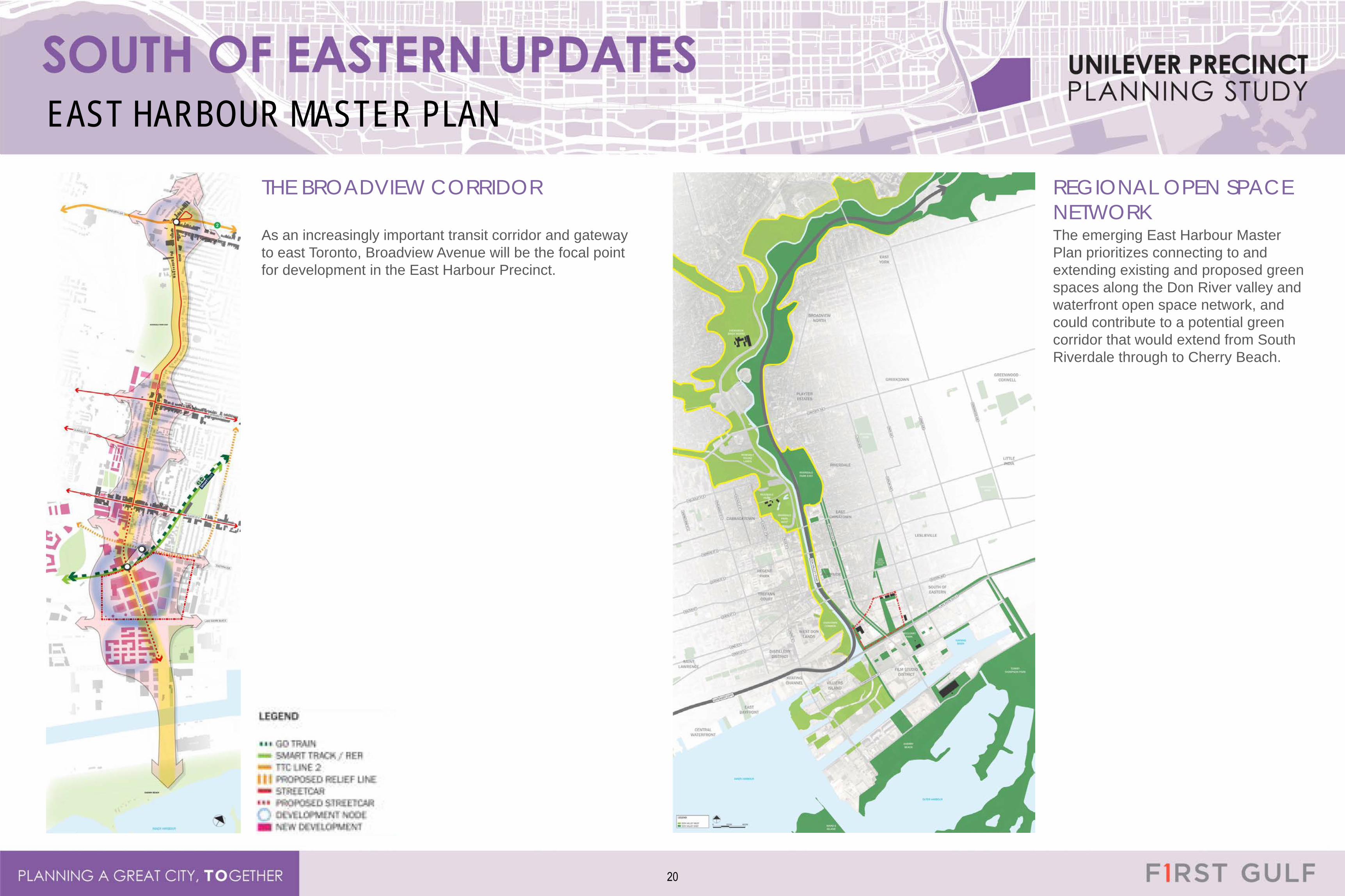
EAST HARBOUR MASTER PLAN
THE BROADVIEW CORRIDOR
As an increasingly important transit corridor and gateway to east Toronto, Broadview Avenue will be the focal point for development in the East Harbour Precinct.
REGIONAL OPEN SPACE NETWORK The emerging East Harbour Master Plan prioritizes connecting to and extending existing and proposed green spaces along the Don River valley and waterfront open space network, and could contribute to a potential green corridor that would extend from South Riverdale through to Cherry Beach.
20
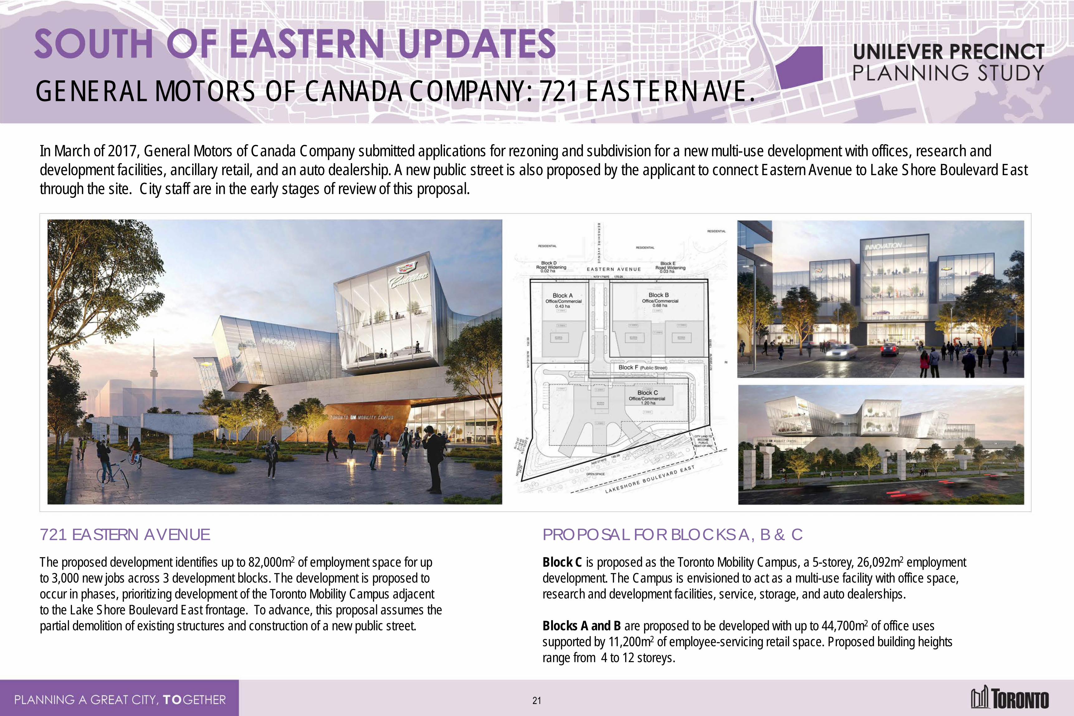
GENERAL MOTORS OF CANADA COMPANY: 721 EASTERN AVE.
In March of 2017, General Motors of Canada Company submitted applications for rezoning and subdivision for a new multi-use development with offices, research and development facilities, ancillary retail, and an auto dealership. A new public street is also proposed by the applicant to connect Eastern Avenue to Lake Shore Boulevard East through the site. City staff are in the early stages of review of this proposal.
721 EASTERN AVENUE The proposed development identifies up to 82,000m2 of employment space for up to 3,000 new jobs across 3 development blocks. The development is proposed to occur in phases, prioritizing development of the Toronto Mobility Campus adjacent to the Lake Shore Boulevard East frontage. To advance, this proposal assumes the partial demolition of existing structures and construction of a new public street.
PROPOSAL FOR BLOCKS A, B & C Block C is proposed as the Toronto Mobility Campus, a 5-storey, 26,092m2 employment development. The Campus is envisioned to act as a multi-use facility with office space, research and development facilities, service, storage, and auto dealerships. Blocks A and B are proposed to be developed with up to 44,700m2 of office uses supported by 11,200m2 of employee-servicing retail space. Proposed building heights range from 4 to 12 storeys.
21
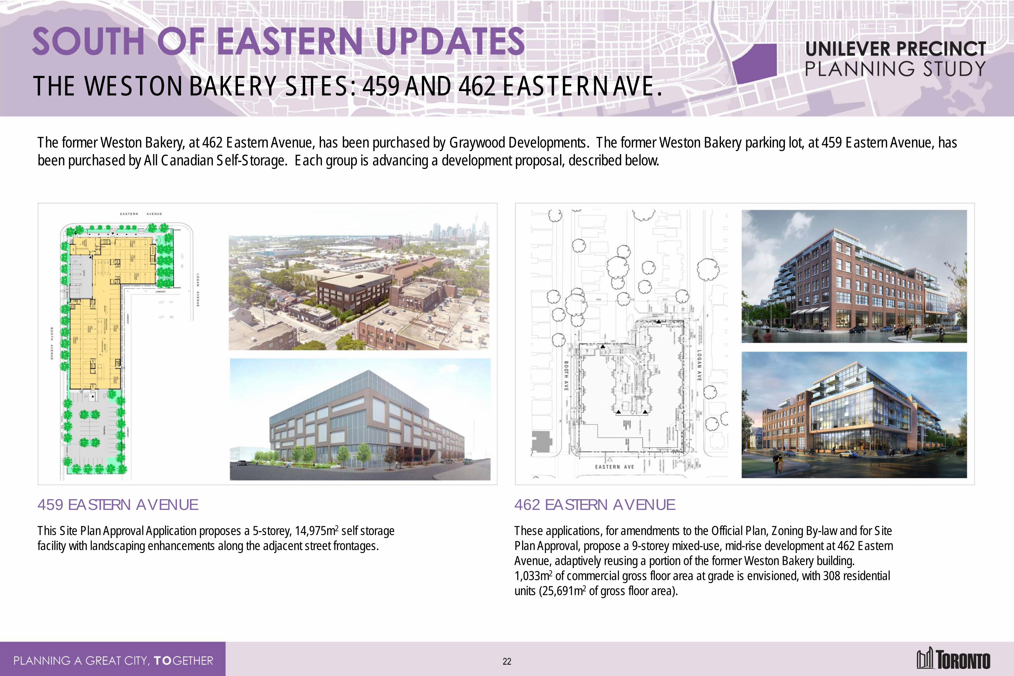
THE WESTON BAKERY SITES: 459 AND 462 EASTERN AVE.
The former Weston Bakery, at 462 Eastern Avenue, has been purchased by Graywood Developments. The former Weston Bakery parking lot, at 459 Eastern Avenue, has been purchased by All Canadian Self-Storage. Each group is advancing a development proposal, described below.
459 EASTERN AVENUE This Site Plan Approval Application proposes a 5-storey, 14,975m2 self storage facility with landscaping enhancements along the adjacent street frontages.
462 EASTERN AVENUE These applications, for amendments to the Official Plan, Zoning By-law and for Site Plan Approval, propose a 9-storey mixed-use, mid-rise development at 462 Eastern Avenue, adaptively reusing a portion of the former Weston Bakery building. 1,033m2 of commercial gross floor area at grade is envisioned, with 308 residential units (25,691m2 of gross floor area).
22
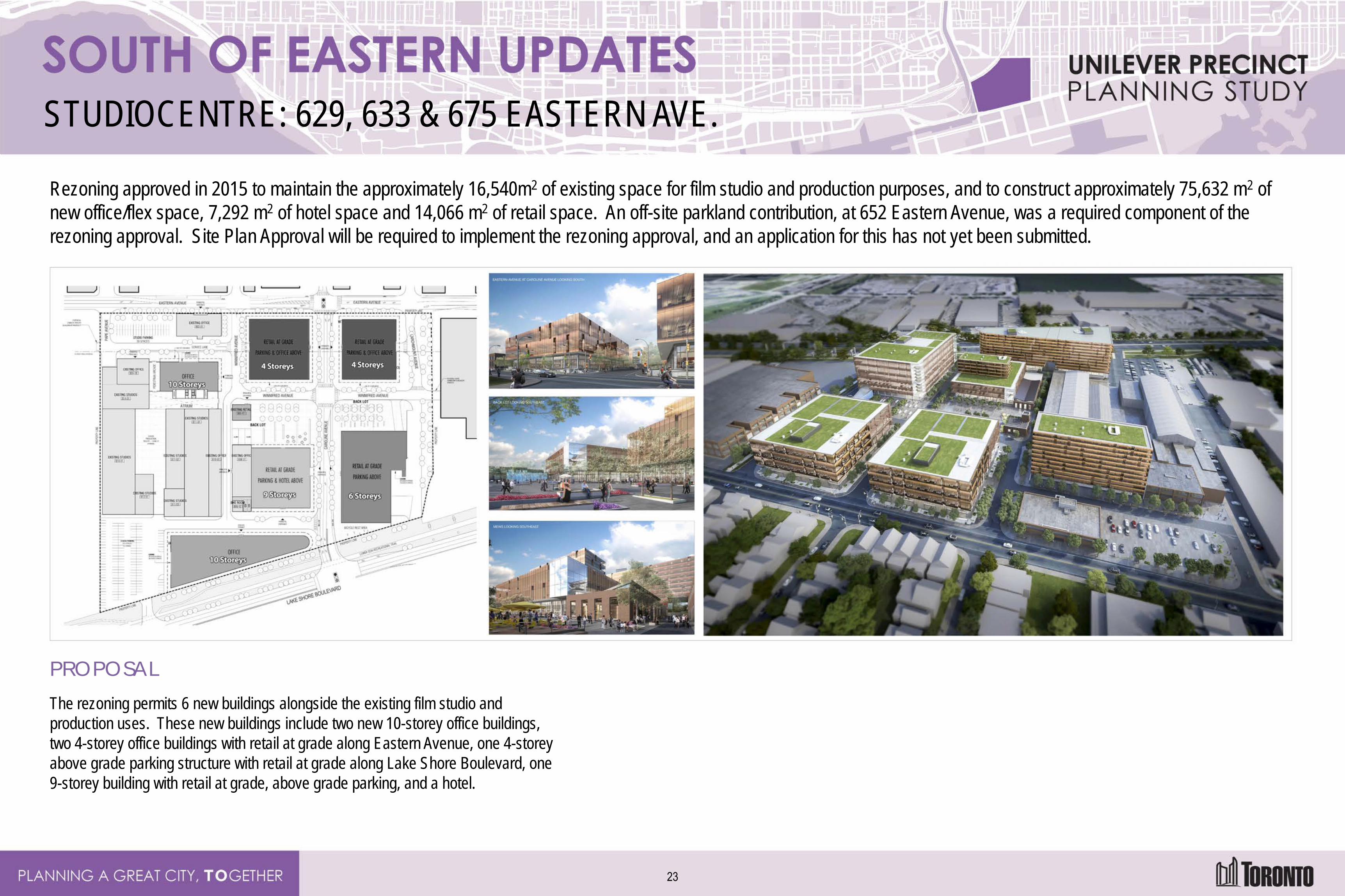
STUDIOCENTRE: 629, 633 & 675 EASTERN AVE.
Rezoning approved in 2015 to maintain the approximately 16,540m2 of existing space for film studio and production purposes, and to construct approximately 75,632 m2 of new office/flex space, 7,292 m2 of hotel space and 14,066 m2 of retail space. An off-site parkland contribution, at 652 Eastern Avenue, was a required component of the rezoning approval. Site Plan Approval will be required to implement the rezoning approval, and an application for this has not yet been submitted.
PROPOSAL The rezoning permits 6 new buildings alongside the existing film studio and production uses. These new buildings include two new 10-storey office buildings, two 4-storey office buildings with retail at grade along Eastern Avenue, one 4-storey above grade parking structure with retail at grade along Lake Shore Boulevard, one 9-storey building with retail at grade, above grade parking, and a hotel.
23
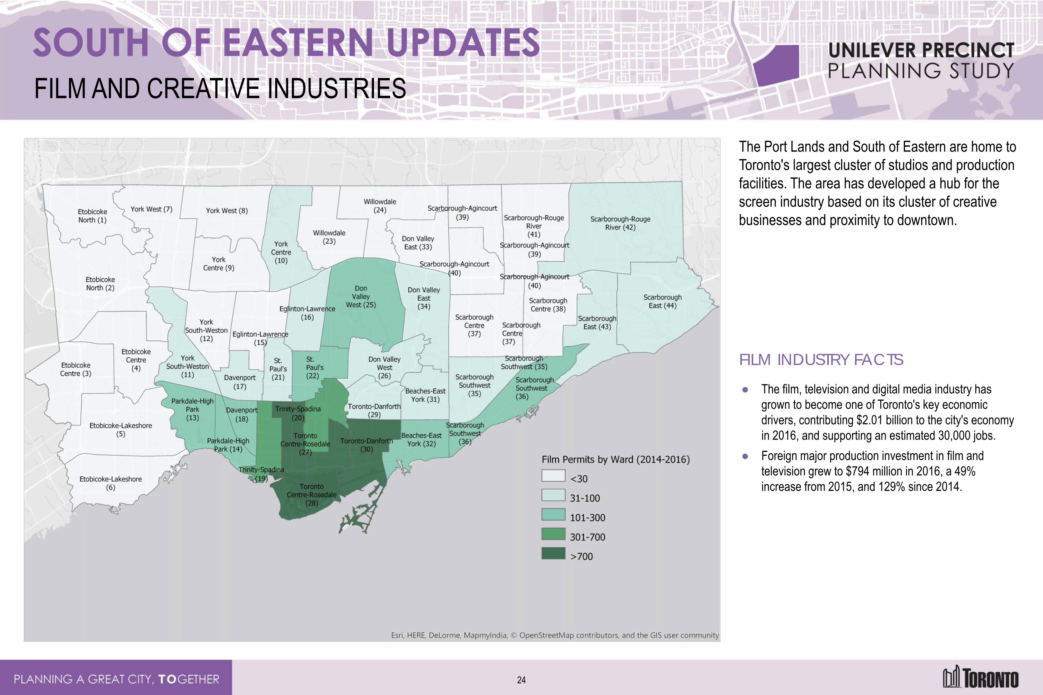
FILM AND CREATIVE INDUSTRIES
The Port Lands and South of Eastern are home to Toronto's largest cluster of studios and production facilities. The area has developed a hub for the screen industry based on its cluster of creative businesses and proximity to downtown.
FILM INDUSTRY FACTS
● The film, television and digital media industry has grown to become one of Toronto's key economic drivers, contributing $2.01 billion to the city's economy in 2016, and supporting an estimated 30,000 jobs.
● Foreign major production investment in film and television grew to $794 million in 2016, a 49% increase from 2015, and 129% since 2014.
24
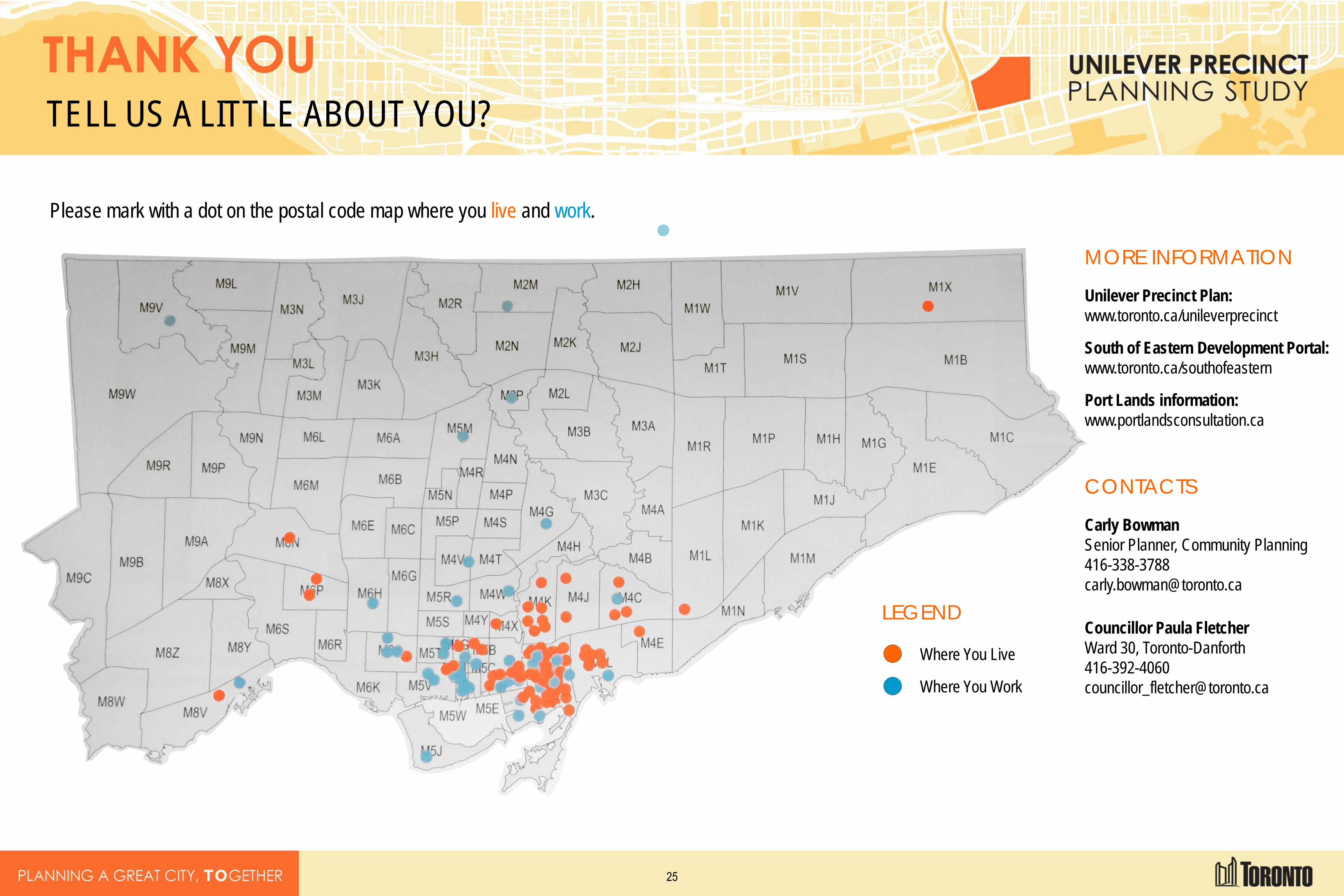
TELL US A LITTLE ABOUT YOU?
Please mark with a dot on the postal code map where you live and work.
LEGEND
Where You Live
Where You Work
MORE INFORMATION
Unilever Precinct Plan: www.toronto.ca/unileverprecinct
South of Eastern Development Portal: www.toronto.ca/southofeastern
Port Lands information: www.portlandsconsultation.ca
CONTACTS
Carly Bowman Senior Planner, Community Planning 416-338-3788 [email protected]
Councillor Paula Fletcher Ward 30, Toronto-Danforth 416-392-4060 [email protected]
25