Embed Size (px)
Citation preview

WFD Reporting Guidance 2022 FINAL Draft V5.21 25-0801-10-2021
1
Status box
Title: WFD Reporting Guidance 2022
Version no.: FINAL Draft V5.2
Date: 26 April 1 October 2021
The WFD reporting guidance for the 3rd River Basin Management Plans was endorsed by the EU Water Directors in their meeting in Helsinki on 26-27 November 2019. The version of this document which was available for endorsement by Water Directors (Draft V3) still contained a number of comments referring to small updates that would be needed for the final version.
The current final draft addresses all those issues. It also addresses one technical issue related to the implementation of the reporting schemas, which arose only after the Water Directors meeting. The modifications introduced to the monitoring schema do not change the information that will need to be reported, but change slightly the way in which the reporting will be organised, in order to simplify the reporting schema by eliminating the need for two separate tables.
In addition to this previously unplanned modification, the other changes introduced in this version are the ones foreseen in the document endorsed by Water Directors, namely:
- A table identifying the changes since the 2016 reporting guidance was added - The reporting of metadata was updated, in line with what was already used for the
2018 reporting on Programmes of Measures and new substances under the EQS Directive
- Figure 3 was updated to reflect the text of the guidance - The links to data on protected areas available in the Eionet vocabularies were
added - The Inventory of Emissions was further streamlined, presented and agreed with
the WG DIS at the meeting in October 2020 - The lists of Priority Substances and River Basin Specific Pollutants in Annexes 8d
and 8b respectively have been updated to take account of the new Priority Substances introduced by Directive 2013/39/EU
As discussed in the WG DIS, SCG and Water Directors meetings, Member States were asked to inform the Commission about elements that they will not be able to report in the form required in this guidance. The deadline for this is the end of 2020.
In early 2021, this guidance was finalised by including options for not reporting wherever needed This way, the final reporting guidance will be completely in line with the tools that will be available for reporting. No other changes are expected to be introduced in this guidance at that stage.
Contacts:
Rolf-Jan Hoeve [[email protected]]
Daniela Buzica [[email protected]]

WFD Reporting Guidance 2022 FINAL Draft V5.21 25-0801-10-2021
2
WFD Reporting Guidance 2022
FINALDRAFT V5 26-04-2021
TABLE OF CONTENTS
1. INTRODUCTION ........................................................................................................... 8
1.1. Purpose of this document ................................................................................. 8
1.2. Structure of the document .............................................................................. 11
1.3. How the European Commission and EEA will use the information provided .. 12
1.4. Components of reporting ............................................................................ 1413
1.5. Reporting of background documents .............................................................. 14
1.6. Mandatory vs voluntary reporting ............................................................... 1514
1.7. Complementarity with other reporting streams ............................................. 15
1.8. Summary of the main changes introduced since reporting of the 2nd RBMPs1817
1.9. Overview of the reporting schemas ................................................................. 21
1.10. Data which Member States may be unable to report ................................. 2423
2. REPORTING AT SURFACE WATER BODY LEVEL (SCHEMA SWB) ................................. 25
2.1. Overview of the reporting contents ................................................................ 25
2.2. Characterisation of surface waters .................................................................. 25
2.3. Pressures and impacts on surface waters ....................................................... 34
2.4. Ecological status and exemptions .................................................................... 40
2.5. Chemical status of surface waters, exemptions and Mixing Zones ................. 51
3. REPORTING AT GROUNDWATER BODY LEVEL (SCHEMA GWB) ................................. 61
3.1. Overview of the structure of the reporting contents ...................................... 61
3.2. Characterisation of groundwater .................................................................... 61
3.3. Pressures and impacts on groundwater .......................................................... 64
3.4. Quantitative status of groundwater and exemptions ...................................... 68
3.5. Chemical status of groundwater and exemptions ....................................... 7574
4. MONITORING (SCHEMA MONITORING) ................................................................ 8584
4.1. Introduction ................................................................................................. 8584
4.2. Contents of the reporting ................................................................................ 91
5. PROTECTED AREAS (SCHEMAS SWB AND GWB) ................................................ 102101
5.1. Introduction ............................................................................................. 102101
5.2. Products from reporting ................................................................................ 104
5.3. Contents of the reporting ........................................................................ 105104

WFD Reporting Guidance 2022 FINAL Draft V5.21 25-0801-10-2021
3
6. REPORTING AT MS LEVEL: COMPETENT AUTHORITIES, RBDS AND SUB-UNITS (SCHEMA RBDSUCA) .......................................................................................................... 112111
6.1. Introduction ............................................................................................. 112111
6.2. Contents of the reporting ........................................................................ 113112
7. REPORTING AT RBD LEVEL FOR SURFACE WATER (SCHEMA SWMET) .............. 118117
7.1. Overview of reporting of methodologies for surface water bodies ........ 118117
7.2. Methodologies for characterisation ........................................................ 119117
7.3. Methodologies for classification of ecological status and potential ........ 125124
7.4. Methodologies for classification of chemical status ................................ 140139
7.5. Overall management objectives (nutrients, river continuity) .................. 149148
7.6. Definition of significant pressures and impacts ....................................... 151150
7.7. Methodologies for exemptions ............................................................... 155153
8. REPORTING AT RBD LEVEL FOR GROUNDWATER (SCHEMA GWMET) .............. 162161
8.1. Overview of reporting of methodologies for groundwater bodies .......... 162161
8.2. Methodologies for characterisation ........................................................ 163161
8.3. Methodologies for classification of chemical status, upward trend assessment, trend reversal, classification of quantitative status, and transboundary co-ordination ................................................................................................ 165164
8.4. Definition of significant pressures and impacts ....................................... 178176
8.5. Methodologies for exemptions ............................................................... 181179
9. REPORTING AT RBD/SUB-UNIT LEVEL FOR RBMP (SCHEMA RBMPPOM) .......... 189187
9.1. Overview of reporting of information on the RBMP ................................ 189187
9.2. RBMP dates, table of contents, more detailed programmes, justifications, public participation ............................................................................................ 189188
9.3. Inputs of pollutants to surface waters and groundwater, including inventories of emissions, discharges and losses of substances listed in Annex I of Directive 2008/108/EC as amended by Annex II of Directive 2013/39/EU ............. 199197
9.4. Water abstractions and exploitation of water resources ........................ 213210
10. REPORTING AT RBD/SUB-UNIT LEVEL FOR PROGRAMME OF MEASURES (SCHEMA RBMPPOM) ........................................................................................................ 221218
10.1. Key Types of Measures (KTM) to tackle significant pressures ................. 221218
10.2. Targeted questions on basic measures and other aspects ...................... 241239
10.3. Estimates of cost of measures ................................................................. 253251
10.4. Co-ordination of measures in international RBDs ................................... 257255
10.5. Progress in the implementation of the programme of measures of the previous planning cycle .......................................................................................... 262260
11. REPORTING AT RBD/SUB-UNIT LEVEL FOR ECONOMIC ANALYSIS AND COST RECOVERY (SCHEMA RBMPPOM) ........................................................................................ 270267
11.1. Introduction ............................................................................................. 270267

WFD Reporting Guidance 2022 FINAL Draft V5.21 25-0801-10-2021
4
11.2. Contents of the reporting ........................................................................ 271268
ANNEXES .................................................................................................................... 281278
ANNEX 1: LISTS OF PRESSURE TYPES, IMPACT TYPES AND DRIVERS ........... 282279
ANNEX 1A: LIST OF PRESSURE TYPES (SIGNIFICANTPRESSURETYPE_ENUM) . 282279
ANNEX 1B: LIST OF IMPACT TYPES (SIGNIFICANTIMPACTTYPE_ENUM) ........ 285282
ANNEX 1C: LIST OF DRIVERS (DRIVER_ENUM) .............................................. 286283
ANNEX 2: TABLE OF ABSTRACTION PRESSURES IN THE CONTEXT OF WATER AVAILABILITY287284
ANNEX 3: SIGNIFICANT PRESSURES MAPPED TO INDICATORS, KTMS AND KTM INDICATORS 288285
ANNEX 4: GROUNDWATER BODIES AND HORIZON ASSIGNMENT .............. 320317
1. GROUNDWATER BODIES AND HORIZON ASSIGNMENT..................................... 320317
1.1. Horizon assignment - Purpose of horizons .............................................. 320317
2. RECOMMENDATIONS FOR HORIZON ASSIGNMENT – TO ENABLE HOMOGENEOUS MAPPING AT A PAN-EUROPEAN SCALE ............................................................. 320317
2.1. Proposal for horizon assignment ............................................................. 320317
2.2. Reporting of GIS information to WISE ..................................................... 321318
2.3. Example – Groundwater bodies .............................................................. 321318
2.4. Sources of information ............................................................................ 325322
ANNEX 5: GUIDANCE FOR REPORTING SPATIAL DATA ................................................ 326323
ANNEX 6: REPORTING ON THE RIVER BASIN MANAGEMENT PLANS – A USER MANUAL327324
ANNEX 7: REPORTING GUIDANCE ON INVENTORIES .................................................. 328325
ANNEX 8: ENUMERATION LISTS .................................................................................. 332329
ANNEX 8A: LIST OF COMMON INTERCALIBRATION TYPES (SWINTERCALIBRATIONTYPE_ENUM) ........................................................................................................................... 332329
ANNEX 8B: LIST OF RIVER BASIN SPECIFIC POLLUTANTS (RBSP_ENUM) ..................... 335332
ANNEX 8C: LIST OF ADDITIONAL POLLUTANTS AND INDICATORS OF POLLUTION (ADDITIONALPOLLUTANT_ENUM) ...................................................................... 370350
ANNEX 8D: LIST OF PRIORITY SUBSTANCES (PS_ENUM) ............................................. 371351
ANNEX 8E: LIST OF CHEMICAL SUBSTANCES (CHEMICALSUBSTANCES_UNION_ENUM)372352
ANNEX 8F: LIST OF UNITS OF MEASUREMENT (UNITOFMEASURE_ENUM) ................ 373353
ANNEX 8G: LIST OF EXEMPTION TYPES FOR SURFACE WATER, GROUNDWATER QUANTITATIVE STATUS AND PROTECTED AREAS (EXEMPTIONTYPE_ENUM) .............................. 374354
ANNEX 8H: QUALITY ELEMENTS ................................................................................. 375355
ANNEX 8I: LIST OF MONITORING PURPOSES (MONITORINGPURPOSE_ENUM) .......... 379357
ANNEX 8J: LIST OF LANGUAGE CODES (LANGUAGECODE_ENUM) ............................. 380358
ANNEX 8K: LIST OF ROLES (ROLES_ENUM) ................................................................. 381359

WFD Reporting Guidance 2022 FINAL Draft V5.21 25-0801-10-2021
5
ANNEX 8L: LIST OF GEOGRAPHICAL SCALES (GEOGRAPHICALSCALE_ENUM) ............. 381359
ANNEX 8M: LIST OF MITIGATION MEASURES (MITIGATIONMEASURE_ENUM) .......... 382360
ANNEX 8N: LIST OF INPUT POLLUTANT CATEGORIES (INPUTCATEGORY_UNION_ENUM)383361
ANNEX 8O: LIST OF CALCULATION METHODS FOR WATER QUANTITY (WQCALCULATIONMETHOD_ENUM) ................................................................. 385364
ANNEX 8P: LIST OF INDICATORS FOR PRESSURE (INDICATORPRESSURE_ENUM) ....... 385364
ANNEX 8Q: LIST OF RELEVANT KTM (KTM_ENUM) ..................................................... 387366
ANNEX 8R: LIST OF INDICATORS FOR KEY TYPES OF MEASURES (INDICATORKTM_ENUM)388367
ANNEX 9: REFERENCE STRUCTURE ............................................................................. 390369
ANNEX 10: UML DIAGRAMS ....................................................................................... 392371

WFD Reporting Guidance 2022 FINAL Draft V5.21 25-0801-10-2021
6
LIST OF ACRONYMS
AWB Artificial Water Body
BQE Biological Quality Element
CIS Common Implementation Strategy
CRS Coordinate Reference Systems
CW Coastal Water (in relation to a water body)
DPSIR Drivers-Pressures-State-Impacts-Responses
EEA European Environment Agency
EIONET European Environment Information and Obervation Network
E-PRTR European Pollutant Release and Transfer Register
EQS Environmental Quality Standard
EQSD EQS Directive
FAQ Frequently Asked Questions
GCS Good Chemical Status
GEP Good Ecological Potential
GIS Geographical Information System
GML Geography Markup Language
GWB Groundwater Body
GWD Groundwater Directive
GWMET Groundwater Methodolgies (title of a schema)
HMWB Heavily Modified Water Body
IED Industrial Emissions Directive
INSPIRE Infrastructure for Spatial Information in the European Community (Directive 2007/2/EC)
IPPC Integrated Pollution Prevention and Control (Directive)
IR Implementing Rules
ISO International Organization for Standardization
KTM Key Type of Measure
LW Lake (in relation to a water body)
maxOccurs Indicates the maximum number of times an item can occur in the current context of a document. If MaxOccurs returns 0, the schema item should not appear. If maxOccurs returns UNBOUNDED(-1), the number of appearances of the schema item is unlimited.
MEP Maximum Ecological Potential
minOccurs Represents the minimum number of times that an item can occur in a document. A value of zero indicates that the item is optional.
MS Member State
MSFD Marine Strategy Framework Directive
NBL Natural Background Levels
NiD Nitrates Directive
NWRM Natural Water Retention Measures
PoM Programme of Measures
QE Quality Element
RBD River Basin District
RBDSUCA River Basin District Sub Unit Competent Authority (title of a schema)

WFD Reporting Guidance 2022 FINAL Draft V5.21 25-0801-10-2021
7
RBMP River Basin Management Plan
RBMPPoM Riber Basin Management Plan Programme of Measures (title of a schema)
RBSP River Basin Specific Pollutant
ROD Reporting Obligations Database
RPA Pathway Oriented Approach
RW River (in relation to a water body)
SCG Strategic Co-ordination Group
SEIS Shared Environmental Information Systems
SFA Substance Flow Analysis
SIIF Structured Implementation and Information Framework
SoE State of the Environment
SOER State of the Environment Report
SU Sub Unit
SWB Surface Water Body
SWD Staff Working Document
SWMET Surface Water Methodologies (title of a schema)
TeW Territorial Water (in relation to a water body)
TG Technical Guideline
TW Transitional Water (in relation to a water body)
UML Unified Modeling Language
URIs Uniform Resource Identifiers
URL Uniform Resource Locator
UWWT Urban Waste Water Treatment Directive
WB Water Body
WEI+ Water Exploitation Index
WFD Water Framework Directive
WG DIS CIS Working Group on Data and Information Sharing
WISE Water Information System for Europe
WISE-SoE The State of the Environment data flow to the Water Information System for Europe
WP Work Programme
XML Extensible Markup Language
XSD XML Schema DefinitionGCS

WFD Reporting Guidance 2022 FINAL Draft V5.21 25-0801-10-2021
8
1. INTRODUCTION
1.1. Purpose of this document
The purpose of this document is to provide Member States with guidance on how the various aspects of implementation of the Water Framework Directive (WFD) should be reported to the European Commission. This WFD Reporting Guidance is largely based on the Reporting Guidance for the 2nd River Basin Management Plans.
In 2000, building on the achievements of existing EU water legislation, the Water Framework Directive (WFD) introduced new and ambitious objectives to protect aquatic ecosystems in a more holistic way, while considering the use of water for life and human development. The WFD incorporated into a legally binding instrument the key principles of integrated river basin management:
The participatory approach in planning and management at river basin scale.
The consideration of the whole hydrological cycle and all pressures and impacts affecting it.
The integration of economic and ecological perspectives into water management.
It provided a framework to balance high levels of environmental protection with sustainable economic development.
The WFD foresaw a long implementation process leading to the adoption of the first River Basin Management Plans (RBMPs) in 2009, which described the actions envisaged to implement the Directive. The plans were expected to deliver the objectives of the WFD, including the non-deterioration of water status and the achievement of good status, by 2015.
The WFD introduced a number of key principles into the management and protection of aquatic resources:
1. The integrated planning process at the scale of river basins, from characterisation to the definition of measures to reach Environmental Objectives.
2. A comprehensive assessment of pressures and impacts on, and the status of, the aquatic environment, including from the ecological perspective.
3. The economic analysis of the measures proposed or taken, and the use of economic instruments.
4. The integrated water resources management principle that encompassed targeting Environmental Objectives with the objectives of water management and related policies.
5. Public participation and active involvement in water management.
The key objectives of the WFD are:
No deterioration of status for surface and groundwater bodies, and protection, enhancement and restoration of all water bodies.
WFD Reporting Guidance 2022 FINAL Draft V5.21 25-0801-10-2021
9
Achievement of good status for all water bodies by 2015. This comprises the objectives of good ecological status and good chemical status for all natural surface water bodies; good ecological potential and good chemical status for all heavily modified or artificial water bodies; and good quantitative status and good chemical status for all groundwater bodies.
Progressive reduction of pollution of priority substances and phase-out of priority hazardous substances in surface water bodies, and prevention and limitation of the input of pollutants in groundwater bodies.
Reversal of any significant, upward trend of pollutants in groundwater bodies.
Achievement of standards and objectives set for protected areas in Community legislation.
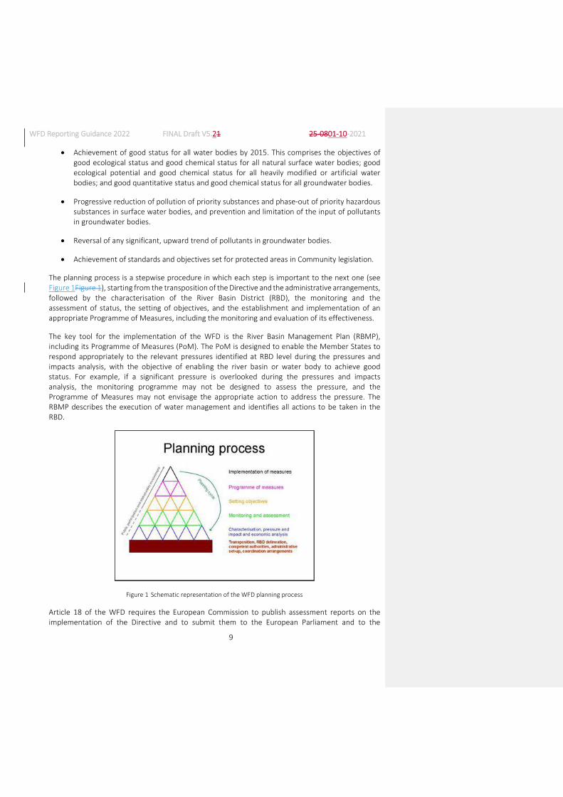
The planning process is a stepwise procedure in which each step is important to the next one (see Figure 1Figure 1), starting from the transposition of the Directive and the administrative arrangements, followed by the characterisation of the River Basin District (RBD), the monitoring and the assessment of status, the setting of objectives, and the establishment and implementation of an appropriate Programme of Measures, including the monitoring and evaluation of its effectiveness.
The key tool for the implementation of the WFD is the River Basin Management Plan (RBMP), including its Programme of Measures (PoM). The PoM is designed to enable the Member States to respond appropriately to the relevant pressures identified at RBD level during the pressures and impacts analysis, with the objective of enabling the river basin or water body to achieve good status. For example, if a significant pressure is overlooked during the pressures and impacts analysis, the monitoring programme may not be designed to assess the pressure, and the Programme of Measures may not envisage the appropriate action to address the pressure. The RBMP describes the execution of water management and identifies all actions to be taken in the RBD.
Figure 1 Schematic representation of the WFD planning process
Article 18 of the WFD requires the European Commission to publish assessment reports on the implementation of the Directive and to submit them to the European Parliament and to the

WFD Reporting Guidance 2022 FINAL Draft V5.21 25-0801-10-2021
10
Council. The assessment is based on information reported by Member States, comprising the published RBMPs and accompanying documentation required according to Article 15, the electronic reporting through the Water Information System for Europe (WISE) in predefined formats agreed by the Water Directors, and any additional, supporting background documents that the Member States consider relevant.
The RBMPs are comprehensive documents that cover many aspects of water management, consisting of hundreds to thousands of pages of information, published in national languages. The assessment of the RBMPs is a very challenging and complex task and involves dealing with extensive information in more than 20 languages. The quality of the European Commission’s assessments relies on the quality of the Member States' reports. Bad or incomplete reporting can lead to wrong and/or incomplete assessments. It is recognised that reporting requires a significant commitment in terms of time and resources from the Member States, in particular the electronic reporting to WISE.
After the reporting of the first RBMPs, a thorough review of the reporting requirements for the second RBMPs has been carried out and, as a result, the Common Implementation Strategy (CIS) ‘Guidance Document No. 21: Guidance for reporting under the Water Framework Directive’ which facilitated the reporting of RBMPs in 2010 has been substantially revised. The more structured way in which the electronic reporting was organised, with much less reliance on text summaries of information, allowed the Commission and the EEA to develop visualisation tools for much of the reported data, allowing for a much more readily usable presentation of the data.
The automatic quality checks that were introduced also avoided many mistakes in the reporting and the need for the Commission to go back to Member States, sometimes long after the reporting had been done, to ask for corrections. Due to the complexity of the reporting, however, gaps in quality checks were identified and, where possible, corrected even during the reporting period.
The current document is largely based on the Reporting Guidance that was produced for the second RBMPs, as requested by the WG DIS and confirmed by the SCG and Water Directors. It takes into account all the developments in quality assurance since the previous Guidance was finalised, hopefully presenting a stable environment for reporting and guaranteeing that thedata reported by Member States is as error-free as possible.
The WFD Reporting Guidance, as with any other CIS Guidance, is the outcome of an informal, collaborative process between the European Commission, Member States, and other stakeholders, including other EU institutions. As such, it does not alter the requirements of the WFD or the Member States’ obligations therein.
It is important to recall that reporting should be based on the obligations in the WFD. The reporting requirements presented in this WFD Reporting Guidance have been agreed through the CIS process and Member States have a commitment to report the electronic data and information requested to WISE. The reporting of data and information in accordance with this WFD Reporting Guidance should ensure completeness and comparability in both the reporting and assessment of the Member States’ implementation of the WFD.
It is recognised, however, that it may be difficult for some Member States to provide all the data and information in the format and structure requested by this Guidance. The reasons for non-

WFD Reporting Guidance 2022 FINAL Draft V5.21 25-0801-10-2021
11
reporting or incomplete reporting of specific data and information may be varied and may not necessarily be due to gaps in implementation.
The possibility of incomplete reporting by some Member States was addressed, for the second RBMPs only, with the inclusion of an Annex 0 to reporting, through which Member States detailed what they were not able to report and why that was the case. This process, which needed the introduction of a manual component in an otherwise automatic procedure, created, among others, very significant problems with the implementation of the automatic quality checks. This situation is therefore being addressed differently for the third RBMPs, by allowing for an option of “no data available” or similar for the schema elements which some Member States are unable to report.
The fact that some Member States may not be able to report certain data and information is not a reason to exclude these requirements from this Guidance. A lowest common denominator approach should be avoided.
Finally, this guidance reflects that status quo of reporting prior to the publication of the Water Fitness Check. The Water Fitness Check concluded that the existing regulatory framework is broadly fit for purpose, but with scope for improvement in relation to ‘enhancing administrative simplification and digitalisation’. Also, the EU Green Deal1 , the draft Zero Pollution Action Plan2 and the 2020 Council conclusions on ‘Digitalisation for the benefit of the environment’3 include elements related to digitalisation and streamlining of both monitoring and reporting requirements. The present guidance is unaffected by this, but work to follow-up on these particular issues will start soon after the 2022 reporting.
1.2. Structure of the document
This WFD Reporting Guidance is largely structured on the basis of the schemas used for reporting the second RBMPs. Chapters are structured on the basis of the level of reporting, i.e. surface water body, groundwater body, RBD or Member State. This means that information on certain issues may be distributed through more than one chapter. For example, data on status and pressures at water body level can be found in Chapter 2 for surface water bodies and Chapter 3 for groundwater
1 European Commission Communication – The European Grean Deal: https://eur-
lex.europa.eu/resource.html?uri=cellar:b828d165-1c22-11ea-8c1f-01aa75ed71a1.0002.02/DOC_1&format=PDF. Quotes: (page 4) “The EU should also promote and invest in the necessary digital transformation and tools as these are essential enablers of the changes”; and (page 9) “Digital technologies are a critical enabler for attaining the sustainability goals of the Green deal in many different sectors…..” and “Digitalisation also presents new opportunities for distance monitoring of air and water pollution, or for monitoring and optimising how energy and natural resources are used.”.
2 4. Administrative simplification and digitalization: there are possibilities for reducing the administrative burden, streamlining both monitoring and reporting requirements (also between the WFD and the Marine Strategy Framework Directive - MSFD) and better tapping into digital technologies to secure a faster, more accurate and better visualized outcome of the data on the actual status of freshwaters
3 https://data.consilium.europa.eu/doc/document/ST-13957-2020-INIT/en/pdf. Quote (page 8): “… Emhasises the importance of strengthening the European Environment Agency as one of the key providers of timely, targeted, relevant, reliable and comparable environmental information, using inter alia the data made available by the Member States in the context of INSPIRE, to policymakers and the public while taking into account data consistency and synergies with information provided by the European Statistical System and other competent authorities as far as possible”.

WFD Reporting Guidance 2022 FINAL Draft V5.21 25-0801-10-2021
12
bodies, whereas information on the methodologies on pressures and status can be found in Chapters 7 and 8, respectively.
Each chapter and sub-chapter includes the following sections:
Introduction
This section summarises the WFD obligations for the relevant topic and their role in the planning process.
How the European Commission and the EEA will use the information?
According to Article 18.2.b of the WFD, the European Commission must include a review of the status of surface water and groundwater in their reports on the implementation of the WFD, in co-ordination with the EEA. Both the European Commission and the EEA will therefore use the data and information reported by Member States. This section identifies how the European Commission and the EEA will use the data and information reported, including the compliance checking and analysis that will be carried out and the products that will be developed from the data and information, such as tables, graphs, charts and maps. The list of products in the WFD Reporting Guidance is not exhaustive, i.e. the European Commission and the EEA may develop additional products later on in close consultation with Member States within the CIS process.
Contents of the reporting
o A sketch of the reporting schemas in XSD format is available online in the WFD reporting resources page in Eionet.
o A technical description of the data to be reported. This includes the respective schema element name; the field type or facet of the element (e.g. string, enumeration list, etc); some guidance regarding the schema element (e.g. whether it is required, conditional or optional – see section 1.6 below, its multiplicity, any related or supporting information that should also be reported, the content of enumeration lists, etc); and a brief description of the associated automatic quality checks.
o Guidance on the expected content of the RBMPs or background documents. This is not intended to be exhaustive in terms of what the Member States have to include in their RBMPs or background documents, but to provide certain concrete elements of information that should be reported.
o Glossary providing clarification of terms and reporting requirements (where it is considered necessary).
1.3. How the European Commission and EEA will use the information provided
The information provided by the Member States will be used by the European Commission for the following purposes:

WFD Reporting Guidance 2022 FINAL Draft V5.21 25-0801-10-2021
13
Assessment of whether the implementation of the requirements of the WFD and its Daughter Directives (Groundwater Directive (2006/118/EC4); Directive on Environmental Quality Standards (2013/39/EU5)) is sufficient in each Member State (i.e. compliance assessment) and to assess what can be improved in the future.
Evaluation of the WFD and its Daughter Directives to identify whether the set objectives of the Directives have been achieved and to assess what can be improved in the future.
Preparation of reports for the European Parliament, Council of Ministers and the general public on the implementation of the WFD and its Daughter Directives and the improvements in the state of the water environment that have been achieved as a result.
Determination of the appropriate level of EU funding to support the implementation of policies (e.g. through structural, cohesion, rural development and other funding).
In addition, the EEA will use the information provided to supplement the data collected through its own reporting streams when producing European, pan-European and regional integrated environmental data and indicator sets, assessments and thematic analyses.
As with the reporting of the previous RBMPs, reporting is made at different levels:
Water body level
The water body is the assessment level of the WFD. It is the basic physical unit of the Directive to which characterisation, pressures, impacts, objectives, monitoring and assessments are attached. It is, therefore, the main reporting unit for these components of WFD implementation. Information at water body level will be presented in WISE, and aggregation at RBD, national and EU levels will be made possible by this reporting. The European Commission will not be able to properly assess implementation without information reported at water body level.
River Basin District or Sub-unit level
Methodologies and approaches are usually developed at (the national part of) RBD or national level, hence this is the appropriate level for reporting. In addition, measures are reported at (the national part of) RBD or Sub-unit level6, in accordance with the WFD’s requirements to include a summary of the Programme of Measures in the RBMPs. Reporting of measures at water body level would be disproportionate and not useful at EU level.
4 Directive 2006/118/EC of the European Parliament and of the Council of 12 December 2006 on the protection of
groundwater against pollution and deterioration: http://eur-lex.europa.eu/legal-content/EN/TXT/?qid=1410784650720&uri=CELEX:32006L0118
5 Directive 2013/39/EU of the European Parliament and of the Council of 12 August 2013 amending Directives 2000/60/EC and 2008/105/EC as regards priority substances in the field of water policy: http://eur-lex.europa.eu/legal-content/EN/TXT/?qid=1410784774193&uri=CELEX:32013L0039
6 Sub-units were developed by the CIS Working Group Reporting in 2008 as an intermediate reporting scale between water bodies and RBDs for cases where RBDs are very large. The purpose of sub-units is to present aggregated information at an EU level in a meaningful way. The use of Sub-units is completely voluntary, and they can be based either on hydrological boundaries or on administrative boundaries.

WFD Reporting Guidance 2022 FINAL Draft V5.21 25-0801-10-2021
14
As national reporting systems evolve in line with the INSPIRE requirements, physical reporting to the EU level may become less necessary. However, these developments will be supported by linking WISE to the national systems. In the meantime, the European Commission and the Member States will continue working on the basis of the available tools.
The European Commission and the EEA continue to have a need to carry out the in-depth assessment of new and emerging issues in the field of ‘water’, and to identify how these are affecting the water environment and are being addressed by Member States’ policies. The European Commission also faces frequent and time-consuming requests for information from the European Parliament and citizens. Detailed and complete WFD reporting should provide a valuable source of information to support these assessments and requests.
1.4. Components of reporting
The reporting of the third RBMPs will be very similar to the one that was done for the second RBMPs, keeping the same reporting schemas and the same general structure for the electronic reporting and including references to the RBMPs, PoMs and background documents where relevant.
As was already the case for the second RBMPs, some guidance is provided in this document about specific issues which, due to their character, cannot be reported in an electronic way and should therefore be covered by the RBMPs, PoMs or background documents. This guidance is not exhaustive on the contents of those documents, which need to contain all the information required by the WFD, the Groundwater Directive and the EQS Directive.
As was already recognised in the Reporting Guidance for the second RBMPs, it may be difficult for some Member States to provide all data and information requested, due to gaps in implementation or other reasons. At that time, this issue was addressed through a “short explanatory note” using the template provided in Annex 0. Experience with the reporting of the second RBMPs showed that, while this Annex 0 allowed indeed Member States to report even in cases in which they did not have some of the required information, or at least not in the formatand level of aggregation required, it also gave origin to a large number of problems. First of all, it required human intervention in a process that was essentially an automatic one, leading to delays and possibility of mistakes. Secondly, as the human intervention effectively bypassed some of the tests done by the automatic QA/QC procedures, some reporting errors were not detected automatically.
As the structure of reporting for the third RBMPs is very similar to the one used for the second RBMPs, it is expected that there will now be less cases in which Member States will not be able to report the information required. Even so, some cases will remain and therefore a different solution, without using an “Annex 0”, will be used, by allowing an option of “no data available” or similar where necessary. This option is integrated in the automatic QA checks and will therefore not require manual intervention nor bypassing the Q/QC procedures.
1.5. Reporting of background documents
Similarly to what was done for the second RBMPs, Member States have two options for the provision of background documents:

WFD Reporting Guidance 2022 FINAL Draft V5.21 25-0801-10-2021
15
1. Upload a copy of the documents to WISE, including a clear reference (document and section) where required in the electronic data (guidance on the naming of files is included in the user manual for reporting to WISE, see Annex 6).
2. Include a clear reference (document and section) and a URL to the document stored in the Member State. Where this option is selected, the Member State must guarantee that the hyperlink will remain active for a period of at least 6 years after reporting and that the document referred to will not be revised or updated during that period.
1.6. Mandatory vs voluntary reporting
According to the Article 15 of the WFD, Member States are required to submit copies of their RBMPs to the European Commission. Article 20 provides the European Commission with the possibility to develop technical formats for the purposes of reporting through the comitology procedure. This procedure has never been used and instead an agreement was reached in 2003 with Water Directors to develop WISE through the informal CIS process. The latest result of this process is this WFD Reporting Guidance document.
The basis for the electronic reporting of data is therefore informal and not legally binding. However, it is clear that without the electronic reporting of data the European Commission would have difficulties in performing its tasks of compliance checking and reporting to the Council and the European Parliament on the implementation of the WFD.
Against this background, the WFD Reporting Guidance classifies the data elements of the electronic reporting in three categories:
Required: reporting is expected.
Conditional: depending on the contents or the replies to some reporting elements, conditional elements may be required or not necessary.
Optional: these are elements which provide further information if considered appropriate by the Member States, or the information qualified as ‘if possible’ or ‘if available’ in this WFD Reporting Guidance.
The validation rules applied to the reported data, in order to ensure quality assurance, have been developed on this basis. As was already the case for the reporting of the second RBMPs, optional elements have been kept to a minimum as the focus of the reporting exercise is on data and information required for clear and specific purposes.
1.7. Complementarity with other reporting streams
Reporting under the WFD needs to be made in co-ordination with other reporting obligations under other Directives such as the Urban Waste Water Treatment Directive7, Nitrates Directive8, Drinking
7 Council Directive 91/271/EEC of 21 May 1991 concerning urban waste-water treatment http://eur-
lex.europa.eu/legal-content/EN/TXT/PDF/?uri=CELEX:31991L0271&qid=1439549071803&from=EN

WFD Reporting Guidance 2022 FINAL Draft V5.21 25-0801-10-2021
16
Water Directive9, Bathing Water Directive10, and Marine Strategy Framework Directive11, etc, and also with the EEA’s State of the Environment (SoE) data flows. Complementarity of these data flows needs to be ensured, avoiding duplications and reusing as much data and information as possible for different purposes.
1.7.1. EEA's State of the Environment (SoE) reporting
In the mid 1990s the EEA established reporting of water data under its Regulation12, with data on water quality from a range of monitoring stations in its member countries, as part of the EEA-EIONET. In Chapter 4, on monitoring, the importance of having the WFD monitoring network co-ordinated with the stations reported to EEA SoE is described. The observation results (e.g. water quality concentrations, ecological quality ratios (EQRs) for biological quality elements) from stations in the WFD monitoring networks should as far as possible be reported to EEA Waterbases. These data will be used by the EEA in producing trend assessments and overviews of the status of, and pressures affecting, Europe’s surface waters and groundwater.
Since 2008, this EIONET reporting contains also data on emissions to water and water quantity. The information on emissions and water quantity plays an important role as pressure information in EEA’s State of Environment reporting, as it allows for complementing assessments in the DPSIR framework. The SoE information is, in most cases, more detailed than the information in WFD reporting, as it is reported for the purpose of the environmental assessments and trend analysis that are included in the SoE reports that EEA compiles every 5 years with its member countries.
The details about how the data flows on SoE emissions and on SoE water quantity are structured are agreed with the Member Countries of EEA (EU Member States plus Norway, Iceland, Liechtenstein, Switzerland and Turkey) in the context of the EIONET and described in the SoE-reporting guidance. The reporting is set as an annual reporting exercise at the level of RBD (or national portion of RBD) or Sub-unit.
The current structure of the data sets reported under SoE emissions and water quantity is, in its data model, very close to what is required under the WFD for the pressure information on emissions to water and water quantity (water abstraction and use).
8 Council Directive 91/676/EEC of 12 December 1991 concerning the protection of waters against pollution caused
by nitrates from agricultural sources http://eur-lex.europa.eu/legal-content/EN/TXT/PDF/?uri=CELEX:31991L0676&from=EN
9 Council Directive 98/83/EC of 3 November 1998 on the quality of water intended for human consumption http://eur-lex.europa.eu/legal-content/EN/TXT/PDF/?uri=CELEX:31998L0083&from=en
10 Directive 2006/7/EC of the European Parliament and of the Council of 15 February 2006 concerning the management of bathing water quality and repealing Directive 76/160/EEC http://eur-lex.europa.eu/legal-content/EN/TXT/PDF/?uri=CELEX:32006L0007&qid=1439550272397&from=EN
11 Directive 2008/56/EC of the European Parliament and of the Council of 17 June 2008 establishing a framework for community action in the field of marine environmental policy (Marine Strategy Framework Directive) http://eur-lex.europa.eu/legal-content/EN/TXT/PDF/?uri=CELEX:32008L0056&qid=1439550339839&from=EN
12 Regulation (EC) No 401/2009 of the European Parliament and of the Council of 23 April 2009 on the European Environment Agency and the European Environment Information and Observation Network (Codified version) http://eur-lex.europa.eu/legal-content/EN/TXT/PDF/?uri=CELEX:32009R0401&qid=1439550465427&from=EN

WFD Reporting Guidance 2022 FINAL Draft V5.21 25-0801-10-2021
17
To facilitate the WFD reporting and to avoid double reporting, most of the information required in chapters 9.29.3 and 0 of this document could be obtained directly or derived from the information reported to EEA under the SoE reporting stream, provided that MS participate in the SoE reporting.
The practical process of using already reported SoE information in the context of the WFD could be described as follows:
Figure 2 Synergies between WFD and SoE reporting
It will be up to each Member State, if they participated in the EEA SoE reporting, to decide whether path A or path B will be followed for each parameter. The SoE information will be used only if the Member State does not chose to provide new information specifically for the purpose of the WFD.
SoE reporting happens on an annual basis (once a year also for parameters with a higher resolution e.g. monthly or seasonal data for water use). As the WFD requires information only every 6 years, agreements need to be made on aggregation and use in the WFD context.
The information about which member States are participating in the SoE reporting and with which parameters can be seen in the annual priority data overview published by the EEA.
In terms of technical implementation, both information flows are held at EEA in a common data space (grey area in the graph above). Therefore, when path B will be followed the SoE information can easily be made available in the WFD parts of the data space.
The details on how path B would function in terms of conditionalities in schema elements and mapping of data structure is further described in section 9.2 and section 9.3 of this document.
1.7.2. Reporting under other water and marine directives
The development of WISE over the past few years has made significant progress in streamlining the reporting requirements under the various water directives, avoiding double reporting and promoting the principle ‘report once, use many’. The various water directives, such as Urban Waste
WFD Reporting Guidance 2022 FINAL Draft V5.21 25-0801-10-2021
18
Water Treatment, Nitrates, Drinking Water and Bathing Water Directives, include specific requirements that need to be reported within a particular timetable under the respective reporting streams. However, streamlining with the WFD means that there is no need to report the same information several times (e.g. Sensitive Areas, Nitrate Vulnerable Zones) and appropriate links have been established, mainly through the use of the water body code. Building on this WFD Reporting Guidance and the processes to review the reporting requirements under other water-related directives, the objective is to continue improving this alignment to reduce the reporting burden on Member States and enable a more useful and efficient use of the available information.
It was observed in the reporting of the second RBMPs that the concept of avoiding double reporting led to some misunderstandings. In fact, concerning protected areas, the information which has already been reported under other legal instruments (e.g. the spatial description of the areas) does not have to be reported under the WFD. However, information concerning those protected areas which has not been reported elsewhere (e.g. whether specific objectives have been set under the WFD for the areas and whether those objectives have been met) still needs to be reported under the WFD.
1.8. Summary of the main changes introduced since reporting of the 2nd RBMPs
The following table summarises the main changes in the reporting requirements from the second to the third RBMPs. For information that is more detailed see the relevant noted Sections.
Main changes Where
a) Schema elements deleted
Names of spatial features (RBDs, water bodies, monitoring sites) were removed from the XML schemas, as they are already reported in spatial data. The possibility to report names of features in national language was already available for spatial data.
General
Information previously provided in different schemas (e.g. links between protected areas and water bodies, links between monitoring sites and water bodies, etc) will now be asked only once and the necessary quality checks will be run across schemas. This allows eliminating double reporting, and better automatic quality checking.
General
Reporting on when good status or potential is expected to be reached was simplified, eliminating one schema element each time.
Sections 2 and 3
Several schema elements which related to the application of two Directives on chemical status (2008 and 2013) were deleted as they are no more relevant.
Sections 2 and 7

WFD Reporting Guidance 2022 FINAL Draft V5.21 25-0801-10-2021
19
The Monitoring schema was simplified by grouping elements with similar types of information.
Section 4
Information on the water categories covered by monitoring programmes was deleted, as the information can be generated from the data available for monitoring sites at water body level.
Section 4
Information on monitoring purpose is asked only concerning investigative, operational and surveillance monitoring. All the other previously listed purposes are already reported in spatial data (the class MonitoringPurpose was deleted, as the two elements it contained were moved to another class).
Section 4
Information on additional objectives for protected areas was reorganised in a smaller number of schema elements.
Section 5
Information on areas of RBDs and Sub-units is not requested, as these can be calculated from spatial data (this and the removal of the request for names allowed for the deletion of the whole class SubUnit, with only one schema element being moved elsewhere).
Section 6
Some of the information in the Methodologies schema about applicability to different water categories, about water bodies in which chemical status is not monitored and about mixing zone designation was deleted, as the information can be generated from the reporting on status assessment at water body level.
Section 7
Reporting on trend reversal for groundwater pollutants was simplified, eliminating cases of double reporting.
Section 8
Reporting on whether an RBD is international was deleted in the class Coord, as the information is already available elsewhere.
Section 9
b) Schema elements added
The reporting on threshold values was modified as discussed in WG Groundwater. The model proposed, which has a few new elements on the use of criteria values for different uses, was tested by WG Groundwater for a number of Member States, in order to assess the feasibility of providing the information requested. These “pilot” Member States did not have problems with the additional reporting requested, the
Sections 3 and 8

WFD Reporting Guidance 2022 FINAL Draft V5.21 25-0801-10-2021
20
reasoning for which is explained in the guidance. In addition, at the request of the Member States, a new element on whether a process is in place that will lead to trend reversal was added.
The information provided before on application of Article 9(4) to different water uses created some confusion. It was therefore replaced with a question on whether or not cost recovery is applied. One generic question on whether Article 9(4) was used at all was added, but details should only be provided in the RBMP or background documents.
Section 10
c) Clarifications on the information requested
The guidance now includes all quality checks which were developed when necessary during the previous reporting. In general, reverse checking was added where necessary (“report if and only if…”). Additional checks were added where serious problems with inconsistent data were found in the previous reporting.
General
The need to use “other” options in enumeration lists only when the options available do not cover what needs to be reported was stressed over the whole guidance.
General
The guidance was modified so that reservoirs should be classified as lake water bodies. The Working Group found that the previous recommendation in the guidance, to report dammed rivers as heavily modified rivers, but use lake typology for classification of status was confusing. The information on the water category before damming is still part of the reporting, so no information is lost.
Section 2
An explanation was added about the applicability of Directives 2008/105/EC and 2013/39/EU with respect to the list of substances to be considered and the EQSs to be used for classification of chemical status.
Section 2
Reporting of transboundary water bodies was clarified, to include all courses of water which are transboundary, independently of how the delineation of individual water bodies was done.
Sections 2 and 3
Clarifications were added on the need to report monitoring of RBSPs as chemical monitoring, even if
Section 4

WFD Reporting Guidance 2022 FINAL Draft V5.21 25-0801-10-2021
21
they are part of ecological status
It was clarified that the table linking exemptions to impacts and drivers is not required and should be done only if data is available or can be obtained with reasonable effort. This was already the case, but the text in the guidance was not sufficiently clear.
Section 7
Priority substances added in the 2013 amendment of the EQS Directive were moved from the enumeration list for River Basin Specific Pollutants to the one for Priority Substances, grouping them when the Standards apply to the whole group and not to individual substances. The individual substances of these groups however remained in the enumeration list for River Basin Specific Pollutants.
Annex 8
Some options were added to a few enumeration lists as requested by several Member States.
Annex 8
d) Annex 0 was deleted
Options will be provided for Member States who, for various reasons, cannot report some of the required information. This was already done for the information concerning indicators of gap to good status and of Key Types of Measures, to illustrate the way in which it will be done elsewhere. By the end of 2020, Member States need to inform the Commission about the information they will not be able to report for the 3rd RBMPs, so that the necessary options can be added.
General
1.9. Overview of the reporting schemas
One very significant simplification concerning the reporting of the third RBMPs in comparison with the previous reporting is that Member States do not need to report again spatial information, unless there were changes since the 2nd RBMPs (e.g. re-delineation of water bodies, setting up of new monitoring stations, etc). In these cases, Member States will be able to download a copy of their previous spatial data, make the necessary modifications and upload again the completespatial files, following the spatial data reporting guidance available separately (also mentioned as Annex 5 of this Reporting Guidance).
For the non-spatial data, seven reporting schemas are used for the third RBMPs, the same as for the second RBMPs. They are described in some detail in the following chapters of the guidance:
Schema name Type Reporting scale Contents Chapter
RBDSUCA XML National (1 file River Basin Districts, Sub- 6

WFD Reporting Guidance 2022 FINAL Draft V5.21 25-0801-10-2021
22
Schema name Type Reporting scale Contents Chapter
per MS) units and Competent Authorities
SWB XML RBD (1 file per RBD)
Surface water bodies (information at water body level)
2 and 5
GWB XML RBD (1 file per RBD)
Groundwater bodies (information at water body level)
3 and 5
Monitoring XML RBD (1 file per RBD)
Monitoring programmes and monitoring sites for surface and groundwater bodies
4 and 5
SWMET XML RBD (1 file per RBD)
Information on methodologies linked to surface water
7
GWMET XML RBD (1 file per RBD)
Information on methodologies linked to groundwater
8
RBMPPoM XML RBD (1 file per RBD)
Information on the River Basin Management Plans, Programme of Measures and Economic Analysis
9, 10 and 11
All XML schemas include a header with the following information (with the exception of the element euRBDCode, which is not included in the RBDSUCA file as there is only 1 file per Member State):
Schema element: countryCode
Field type / facets: CountryCode_Enum
Properties: maxOccurs =1 minOccurs = 1
Guidance on completion of schema element: Required. Two-letter ISO country code13.
Schema element: euRBDCode
Field type / facets: FeatureUniqueEUCodeType
Properties: maxOccurs =1 minOccurs = 1
Guidance on completion of schema element: Required (except in the RBDSUCA file). Unique EU code of the River Basin District. Prefix the RBD’s national, unique code with the Member State’s two-letter ISO country code.
Quality checks: Element check: First 2 characters must be the Member State’s two-letter ISO country code.
13 Member State’s 2-alpha character ISO country code: http://publications.europa.eu/code/en/en-370100.htm (Note:
for Greece use ‘EL’)

WFD Reporting Guidance 2022 FINAL Draft V5.21 25-0801-10-2021
23
Cross-schema check: The reported euRBDCode must be consistent with the codes reported in RBDSUCA/RBD/euRBDCode.
Schema element: created
Field type / facets: WiseDateTime
Properties: maxOccurs =1 minOccurs = 0
Guidance on completion of schema element: Optional. Date of creation of the dataset.
Schema element: creatorElectronicMailAddress
Field type / facets: string
Properties: maxOccurs =1 minOccurs = 1
Guidance on completion of schema element: Required. E-mail address of the point of contact in the organisation responsible for the dataset.
Schema element: creatorOrganisationName
Field type / facets: string
Properties: maxOccurs =1 minOccurs = 1
Guidance on completion of schema element: Required. Name of the organisation doing the reporting.
Schema element: description
Field type / facets: string
Properties: maxOccurs =0 minOccurs = 1
Guidance on completion of schema element: Optional. Description of the dataset.
Schema element: language
Field type / facets: LanguageCode_Enum
Properties: maxOccurs =1 minOccurs = 1
Guidance on completion of schema element: Required. Code of the language of the dataset.
Schema element: license
Field type / facets: URLType
Properties: maxOccurs =1 minOccurs = 1
Guidance on completion of schema element: Required. A legal document giving official permission to do something with the resource. Provide the URL to the licence text of a CC BY compatible licence. Use a persistent identifier to an English or multilingual version of the licence agreement.
Schema element: title
Field type / facets: string
Properties: maxOccurs =1 minOccurs = 0
Guidance on completion of schema element: Optional. Name given to the dataset.
Schema element: rights

WFD Reporting Guidance 2022 FINAL Draft V5.21 25-0801-10-2021
24
Field type / facets: string
Properties: maxOccurs =1 minOccurs = 0
Guidance on completion of schema element: Optional. Information about rights held in and over the resource. If necessary, provide the attribution text required by the licence, or other relevant information.
Schema element: rightsHolder
Field type / facets: string
Properties: maxOccurs =1 minOccurs = 0
Guidance on completion of schema element: Optional. A person or organization owning or managing rights over the resource. This element can be provided if the rights holder reserved rights (e.g. should be contacted for specific uses), or if the rights holder is not the organisation responsible for the dataset.
1.10. Data which Member States may be unable to report
This reporting guidance reflects the agreement reached at Water Directors’ level concerning the contents of the electronic reporting on the 3rd River Basin Management Plans. Several Member States have signalled, however, that some of the data that is required will not be available, at least in the way specified in this guidance.
The ‘Annex 0’ documents that were used in the reporting of the 2nd RBMPs to circumvent this problem introduced a manual intervention in the automatic quality checking, which created serious difficulties. It was therefore agreed that there will not be an ‘Annex 0’ in the reporting of the 3rd RBMPs, replacing it with the possibility to report ‘data not available’ where necessary.
While the choice that is added to some enumeration lists is ‘data not available’ in order to make the text short, it should be clear that this does not mean that no data at all is available on a specific subject, but may also mean that data is available but not in a way that would allow reporting as requiring under the agreed reporting schemas. In these cases, the available data should be included in the River Basin Management Plans or background documents.
When the impossibility of reporting refers to numerical values, Member States should report ‘-9999’, as it is not possible to include and explicit mention such as ‘data not available’. Please make sure that these cases are not reported as ‘0’, which would lead to incorrect interpretation of the data reported.

WFD Reporting Guidance 2022 FINAL Draft V5.21 25-0801-10-2021
25
2. REPORTING AT SURFACE WATER BODY LEVEL (SCHEMA SWB)
2.1. Overview of the reporting contents
Reporting at surface water body level is done for each RBD. For the purpose of presentation in this guidance, the contents of reporting are structured according to the following sub-chapters:
Surface water body characterisation
Pressures and impacts on surface water bodies
Ecological status and exemptions
Chemical status of surface waters, exemptions and mixing zones
The following sections describe the contents of reporting. Links to the UML diagrams of schemas are found in Annex 10.
2.2. Characterisation of surface waters
2.2.1. Introduction
Article 5 of the WFD requires Member States to identify surface water bodies that will be used for assessing progress with, and achievement of, the WFD’s Environmental Objectives. In addition, under certain conditions, Article 4(3) of the WFD allows Member States to identify and designate artificial water bodies (AWBs) and heavily modified water bodies (HMWBs). AWBs and HMWBs are required to achieve Good Ecological Potential (GEP) by 2015. Article 5 of the WFD also requires Member States to analyse the characteristics of surface water bodies (SWBs) and provide a summary report on surface water characterisation including general information on typology of water bodies.
Characterisation is a key step in the implementation of the WFD and it needs to be undertaken thoroughly and correctly in order to enable the objectives of the Directive to be efficiently and correctly achieved. Characterisation should identify all relevant categories and types of water bodies within the RBD for which specific typologies and reference conditions have to be established. This step is crucial in obtaining robust ecological status assessment and classification systems and, in particular, correctly identifying water bodies at risk of failing objectives which will subsequently become the focus for the implementation of necessary measures for the achievement of objectives.
Water bodies should be delineated at a size that allows the identification and quantification of significant pressures and the classification of status (detailed guidance is provided in CIS Guidance Document No. 2: Identification of Water Bodies14). If water bodies are identified that do not permit an accurate description of the status of the aquatic ecosystems, the impacts of pressures may be masked and not detected. If water bodies are too small, there may be too many water bodies for a Member State to deal with in a cost-effective way. The optimum size of a water body is the size that allows the objectives of the Directive to be most efficiently achieved.
14 CIS Guidance Document No. 2: Identification of Water Bodies: https://circabc.europa.eu/sd/a/655e3e31-3b5d-
4053-be19-15bd22b15ba9/Guidance%20No%202%20-%20Identification%20of%20water%20bodies.pdf

WFD Reporting Guidance 2022 FINAL Draft V5.21 25-0801-10-2021
26
Characterisation also requires the assessment of the risk that a water body may fail the objectives of the Directive unless appropriate measures are taken. The results of the risk assessment inform the monitoring of water bodies and the subsequent classification of status. It is crucial that methodologies used in risk assessment are fit for purpose, in the sense of being able to identify and quantify all pressures within the RBD and their potential impact on the status of water bodies (detailed guidance is provided in CIS Guidance Document No. 3: Analysis of Pressures and Impacts15)16. If not, potentially expensive measures may be incorrectly targeted and objectives may not be met.
As part of the characterisation, Member States have defined surface water body types (typology) for each surface water category (i.e. rivers, lakes, transitional waters or coastal waters) in each RBD, and have delineated surface water bodies in accordance with the methodology specified in Annex II of the WFD. This also includes the identification of HMWBs and AWBs. For each surface water body type, type-specific reference conditions have been established representing the values for that surface water body type at high ecological status.
In the previous reporting exercises, it was recommended that HMWBs created by damming rivers were reported as river water bodies, contrary to those created by damming a pre-existing lake, which should be reported as lake water bodies. At the same time, it was stated in the reporting guidance that reservoirs made by damming rivers might be categorised as heavily modified rivers but should be typified and assessed using the elements and tools for lakes, as that is the natural surface water category which reservoirs most closely resemble.
This recommendation was not followed systematically in the reporting and seems to have created some confusion among data providers. It was therefore agreed to modify the way in which reservoirs are reported. Reservoirs should be reported as lake water bodies, so that the way in which they are reported in the delineation of water bodies is consistent with the way in which they are reported concerning water types and assessment of status.
The information on the water body category as it was before the modification took place will still be available through the schema element reservoir.
Territorial waters are not a water body category under WFD. However, Article 2.1 of the WFD indicates that chemical status applies to territorial waters as well. For reporting purposes, in order to establish a link between the chemical status of territorial waters and the location of those waters, Member States are asked to identify pseudo surface water bodies. These serve no other purpose apart from this link with the geographic location of the territorial waters (e.g. to be able to represent them on a map).
Each water category has to be divided into types based on abiotic descriptors such as altitude, geology, size, etc., using system A or system B as described in Annex II of the WFD. The ecological relevance of the different theoretical types has to be demonstrated by cross-checking them against biological data such as macroinvertebrate groups and/or species composition. This is essential to
15 CIS Guidance Document No 3: Analysis of Pressures and Impacts: https://circabc.europa.eu/sd/a/7e01a7e0-9ccb-
4f3d-8cec-aeef1335c2f7/Guidance%20No%203%20-%20pressures%20and%20impacts%20-%20IMPRESS%20(WG%202.1).pdf
16 It is recognised that detailed quantification of pressures is a challenging task in some cases and might not always be possible.

WFD Reporting Guidance 2022 FINAL Draft V5.21 25-0801-10-2021
27
ensure that the types are relevant and fit for the purpose of allowing the robust classification of ecological status of water bodies. Not all water categories occur in every RBD and/or Sub-unit.
Member States are required to identify the ecological status of water bodies by comparing current status with near natural or reference conditions. Reference conditions have to be established for each of the surface water types. They represent the values corresponding to high ecological status for each surface water body type.
According to Annex II of the WFD, reference conditions can be established using different methods (with no particular ranking):
Spatially-based reference conditions using data from monitoring sites, if sufficient undisturbed or minimally disturbed sites are available.
When adequate numbers of representative reference sites are not available in a region/type, predictive modelling, using the data available within a region/type or borrowing data from other similar regions/types for model construction and calibration.
A combination of the above approaches.
Where it is not possible to use these methods, reference conditions can be established using expert judgement.
Establishing reference conditions for many quality elements may involve using more than one of the methods described above.
The WFD protects waters independently of size, but for operational purposes it defines a water body as a ‘discrete and significant’ element of water. The water body is the scale at which status is assessed. The thresholds given in Annex II for system A typology have been used as a possibility for differentiating water bodies, but this approach should not exclude smaller water bodies from the protection of the Directive. Member States have flexibility to decide not to designate very small water bodies where, due to the large number of water bodies in a RBD, this would result in a high administrative burden. Instead, Member States can aggregate these small water bodies into groups or include them as part of a larger contiguous water body of the same surface water category and of the same type.
2.2.2. How will the European Commission and the EEA use the information reported?
The European Commission will use this information to assess whether and how Member States have implemented the key obligations of the WFD.
With regard to the typology of surface water bodies, the key issues in assessing compliance with the Directive will be identifying whether typology is meaningful for the purpose of establishing a classification system for ecological status, whether the level of typology is comparable (in particular in international RBDs) and whether type-specific reference conditions have been adequately defined.
Statistics and information will be provided to the European Parliament at EU level. Information will be provided to the public through WISE.

WFD Reporting Guidance 2022 FINAL Draft V5.21 25-0801-10-2021
28
For information relating to the typology of surface waters in accordance with the WFD, more detailed guidance and information is provided in the CIS Guidance Documents No. 10: River and Lakes - Typology, Reference Conditions and Classification Systems17, No. 5: Transitional and Coastal Waters - Typology, Reference Conditions and Classification Systems18 and No. 2: Identification of Water Bodies19.
2.2.2.1. Products from reporting
The following list identifies some of the products which will be produced by the European Commission or the EEA from the data and information reported by Member States.
Nb Name of product Type of product
Scale of information*
Detailed information displayed
Source of detailed information and aggregation rule
1 Number and average size of surface water bodies
Table EU/MS/ RBD/ SU
Number and size (length/area) of surface water bodies by Category.
Total length or total area of surface water bodies by Category.
Average size of surface water bodies by Category.
Average: sum of length (rivers) or area (rest) of all surface water bodies divided by the number of surface water bodies. Aggregation on the basis of the information reported at water body level.
2 Spatial reference layer of surface water bodies
Spatial dataset
WB Mapping of all surface water bodies.
Spatial dataset including all surface water bodies.
3 Number of types of surface water bodies
Table MS Number of types of surface water bodies reported by Category.
Count of different types on the basis of the information provided at surface water body level.
4 Percentage of HMWBs and AWBs
Map RBD/SU Percentage of HMWBs and AWBs by Category.
Aggregation on the basis of the information reported at water body level.
5 Percentage of natural, HMWBs and AWBs
Chart MS Percentage of HMWBs and AWBs by Category.
Aggregation on the basis of the information reported at water body level.
6 Natural, heavily modified and artificial water bodies
Table MS/ RBD/ SU
Number and size (length/area) of natural water bodies, AWBs and HMWBs by Category.
Aggregation on the basis of the information reported at water body level.
Notes: * Scale of information: EU = European; MS = National, Member State; RBD = River Basin District; SU = Sub-unit; WB = water body
17 CIS Guidance Document No. 10: River and lakes - Typology, reference conditions and classification systems:
https://circabc.europa.eu/sd/a/dce34c8d-6e3d-469a-a6f3-b733b829b691/Guidance%20No%2010%20-%20references%20conditions%20inland%20waters%20-%20REFCOND%20(WG%202.3).pdf
18 CIS Guidance Document No. 5: Transitional and Coastal Waters - Typology, Reference Conditions and Classification Systems: https://circabc.europa.eu/sd/a/85912f96-4dca-432e-84d6-a4dded785da5/Guidance%20No%205%20-%20characterisation%20of%20coastal%20waters%20-%20COAST%20(WG%202.4).pdf
19 CIS Guidance Document No. 2: Identification of Water Bodies: https://circabc.europa.eu/sd/a/655e3e31-3b5d-4053-be19-15bd22b15ba9/Guidance%20No%202%20-%20Identification%20of%20water%20bodies.pdf

WFD Reporting Guidance 2022 FINAL Draft V5.21 25-0801-10-2021
29
2.2.3. Contents of the reporting
2.2.3.1. Information and data to be reported using the schemas
Information regarding the delineation and characterisation of surface water bodies should be reported at surface water body level using the schema SWB.
Schema: SWB
Class: SurfaceWaterBody
Properties: maxOccur: unbounded minOccur: 1
Schema element: euSurfaceWaterBodyCode
Field type / facets: FeatureUniqueEUCodeType
Properties: maxOccurs = 1 minOccurs = 1
Guidance on completion of schema element: Required. Unique EU code of the surface water body. Prefix the surface water body’s national, unique code with the Member State’s 2-letter ISO country code20.
Quality checks: Element check: String length must be within the range of 3 to 42 characters. First 2 characters must be the Member State’s 2-letter ISO country code.
Within-schema check: euSurfaceWaterBodyCode must be unique.
Cross-schema check: euSurfaceWaterBodyCode must be identical to a thematicIdIdentifier reported for surface water bodies in spatial data.
Schema element: euSubUnitCode
Field type / facets: FeatureUniqueEUCodeType
Properties: maxOccurs = 1 minOccurs = 0
Guidance on completion of schema element: Conditional. If the RBD has been divided into Sub-units, report the unique EU code of the Sub-unit where the water body is located. Prefix the Sub-unit’s national, unique code with the Member State’s 2-letter ISO country code.
Quality checks: Conditional check: report if and only if RBDSUCA/RBD/subUnitsDefined is ‘Yes’.
Cross-schema check: The reported euSubUnitCode must be consistent with the codes reported in RBDSUCA/RBD/SubUnit/euSubUnitCode.
Schema element: surfaceWaterBodyCategory
Field type / facets: SWCategoryCode_Enum: RW, LW, TW, CW, TeW
Properties: maxOccurs = 1 minOccurs = 1
Guidance on completion of schema element: Required. Category of surface water body must be reported.
‘RW’ = River water body.
20 Member State’s 2-letter ISO country code: http://publications.europa.eu/code/en/en-370100.htm (Note: for
Greece use ‘EL’)
WFD Reporting Guidance 2022 FINAL Draft V5.21 25-0801-10-2021
30
‘LW’ = Lake water body.
‘TW’ = Transitional water body.
‘CW’ = Coastal water body.
‘TeW’ = Territorial water body.
Territorial waters are not a water body category under the WFD. However, Article 2.1 of the WFD indicates that chemical status applies also to territorial waters. Member States are therefore asked to report the relevant information for the part of territorial waters which extend beyond coastal waters. Non-relevant information, such as water body type or ecological status, should not be reported for territorial waters (see the guidance provided for these schema elements).
Reservoirs should be reported as lake water bodies (‘LW’) even when they were formed by damming rivers. The schema element reservoir allows for distinguishing heavily modified lake water bodies which were originally rivers from those which were already lakes before being modified.
Schema element: naturalAWBHMWB
Field type / facets: NaturalCode_Enum:
Natural
Artificial
Heavily Modified
Properties: maxOccur: 1 minOccur: 1
Guidance on completion of schema element: Required. Indicate whether the surface water body is natural, artificial, or heavily modified.
Note: a water body cannot be both artificial and heavily modified.
A reservoir may be artificial (e.g. constructed for bankside storage) or heavily modified (e.g. a dammed or impounded river).
A canal may be artificial (e.g. specifically constructed for navigation where there was no surface water body before) or heavily modified (e.g. a river that has been deepened or widened or otherwise engineered for navigation).
The identification of the category for heavily modified water bodies (HMWBs), as described in the element surfaceWaterBodyCategory, does not preclude any decision regarding the factors to use in deriving typology and the quality elements to use in the assessment of the HMWBs. According to the WFD Annex II, 1.1.v, the typology differentiation should be undertaken in accordance with the descriptors for whichever natural surface water category most closely resembles the HMWB concerned. Similarly, the quality elements should be those applicable to whichever natural surface water category most closely resembles the HMWB (WFD Annex V, 1.1.5).
The option "Natural" should be chosen for territorial waters.
Quality checks: The option 'Natural' must be chosen if surfaceWaterBodyCategory is 'TeW'.
Schema element: hmwbWaterUse
Field type / facets: HMWBWaterUse_Enum:
Agriculture - land drainage,

WFD Reporting Guidance 2022 FINAL Draft V5.21 25-0801-10-2021
31
Agriculture - irrigation,
Energy - hydropower,
Energy - non-hydropower,
Storage for fisheries/aquaculture/fish farms,
Flood protection,
Industry supply,
Tourism and recreation,
Transport - navigation / ports,
Urban development - drinking water supply,
Urban development - other use,
Wider environment - nature protection and other ecological uses,
Other,
Unknown
Properties: maxOccurs = unbounded minOccurs = 0
Guidance on completion of schema element: Conditional. For HMWBs only, report the water use for which it has been designated. According to Art. 4(3) of the WFD, the water use for which a HMWB was designated is the water use that would be affected significantly by the changes that would be necessary to achieve good ecological status.
‘Wider environment’ can refer to designation in order to maintain nature protected areas and also archaeological sites and patrimony (see CIS Guidance Document No. 4 – Identification and Designation of Heavily Modified and Artificial Water Bodies21).
Quality checks: Conditional check: Report if and only if naturalAWBHMWB is ‘Heavily Modified’.
Schema element: hmwbPhysicalAlteration
Field type / facets: HMWBPhysicalAlteration_Enum:
Locks
Weirs / dam / reservoir
Channelisation / straightening / bed stabilisation / bank reinforcement
Dredging / channel maintenance
Land reclamation / coastal modifications / ports
Land drainage
Other
Properties: maxOccurs = unbounded mixOccurs: 0
21 CIS Guidance Document No. 4 – Identification and Designation of Heavily Modified and Artificial Water Bodies:
https://circabc.europa.eu/sd/a/f9b057f4-4a91-46a3-b69a-e23b4cada8ef/Guidance%20No%204%20-%20heavily%20modified%20water%20bodies%20-%20HMWB%20(WG%202.2).pdf

WFD Reporting Guidance 2022 FINAL Draft V5.21 25-0801-10-2021
32
Guidance on completion of schema element: Conditional. For HMWBs only, report the physical alteration that has resulted in the designation of the surface water body as a HMWB. In the context of designation, physical alterations mean any significant alterations that have resulted in substantial changes to the hydromorphology of a surface water body such that the surface water body is substantially changed in character. In general, these hydromorphological characteristics are long-term and alter both the morphological and hydrological characteristics. Further guidance on the terms is found in the Glossary section below.
Quality checks: Conditional check: Report if and only if naturalAWBHMWB is ‘Heavily Modified’.
Schema element: reservoir
Field type / facets: YesNoUnclearReservoir_Enum:
Reservoir in a water body that was originally a river / rivers
Reservoir in a water body that was originally a lake / lakes
Reservoir in what were originally chained rivers and lakes
Reservoir in what was originally not a water body (artificial reservoir)
Not a reservoir
Properties: maxOccurs = 1 mixOccurs: 0
Guidance on completion of schema element: Conditional. For heavily modified and artificial lake water bodies, indicate whether the water body is a reservoir that has been created by damming a river or a pre-existing lake or artificially fed by water in a location where no water body existed before.
All reservoirs should be reported as heavily modified or artificial lake water bodies. The ‘reservoir’ schema element must be reported so that Member States can clarify whether the water bodies were created by damming rivers or pre-existing lakes or in a location where no water body existed before.
Select ‘Reservoir in a water body that was originally a river / rivers’ only if the whole surface water body represents a reservoir (or part of a reservoir) created by damming a river.
Select ‘Reservoir in a water body that was originally a lake / lakes’ if the whole surface water body represents a reservoir (or part of a reservoir) created by modifying a pre-existing lake, or if the surface water body includes some small reservoirs which are not significant enough to be identified as separate surface water bodies.
Select ‘Reservoir in what were originally chained rivers and lakes’ in cases where the reservoir has been created by damming a water body which contained chained rivers and lakes.
Select ‘Reservoir in what was originally not a water body (artificial reservoir)’ in cases where the reservoir has been created by human activity in a location where no water body existed before, and which has not been created by the direct physical alteration, movement or realignment of an existing water body.
Select ‘Not a reservoir’ if the lake water body is not a reservoir.
Quality checks: Conditional check: Report if and only if surfaceWaterBodyCategory is ‘LW’ AND naturalAWBHMWB is ‘Heavily Modified’ or ‘Artificial’.
Schema element: surfaceWaterBodyTypeCode
WFD Reporting Guidance 2022 FINAL Draft V5.21 25-0801-10-2021
33
Field type / facets: String100Type
Properties: maxOccurs = 1 minOccurs = 1
Guidance on completion of schema element: Required. Member State code for the characterisation type of the surface water body, as reported in the surface water methodology schema (SWMET), and in the RBMP and background documents.
Report 'Not applicable' for territorial waters.
Quality checks:
Within-schema check: 'Not applicable' should be reported if and only if surfaceWaterBodyCategory is 'TeW'.
Cross-schema check: The reported surfaceWaterBodyTypeCode must be consistent with the codes reported in SWMET/SWType/swTypeCode.
Schema element: surfaceWaterBodyIntercalibrationType
Field type / facets: SWIntercalibrationType_Enum (see Annex 8a)
Properties: maxOccurs = unbounded minOccurs = 1
Guidance on completion of schema element: Required. If the surface water body type corresponds with an intercalibration type, report the intercalibration type code (not name).
The intercalibration type reported in this element must be appropriate to the surface water body’s Category.
If there is no corresponding intercalibration type, select ‘Not applicable’.
Report 'Not applicable' for territorial waters.
Quality checks: Within-schema check: 'Not applicable' should be reported if SurfaceWaterBodyCategory is 'TeW'.
Cross-schema check: SurfaceWaterBodyIntercalibrationType must be consistent with the codes reported in SWMET/SWType/swIntercalibrationType, in particular with the codes reported for the same national type, surfaceWaterBodyTypeCode.
Schema element: surfaceWaterBodyTransboundary
Field type / facets: YesNoNotApplicable_Union_Enum: Yes, No, Not applicable
Properties: maxOccurs = 1 minOccurs = 1
Guidance on completion of schema element: Required.
The Directive requires co-ordination among Member States for the management of transboundary waters. Transboundary water bodies are those crossing the border between countries or constituting part of the border between two countries for a certain length. A water body that is entirely within one Member State but is contiguous with a water body in another country is, for the purposes of this reporting, also considered as a transboundary water body.
For the sake of clarity, each Member State should report on its own part of these water bodies. In the case of water bodies shared by more than one country (as opposed to contiguous water bodies), geographic information should therefore be provided for the part of the water body within the reporting Member State and for all elements which have a clear geographical reference (e.g. size, monitoring stations). Each Member State should also report on all elements that apply to the
WFD Reporting Guidance 2022 FINAL Draft V5.21 25-0801-10-2021
34
whole water body (status, pressures, etc), even in the cases in which these are identical in each of the Member States concerned as a result of the co-ordinated management required by the Directive.
Similarly, for water bodies which constitute part of the border between two countries the same principles apply. In the case of rivers represented as lines, the same line will have to be reported by both Member States concerned, instead of reporting different but adjacent areas, as is the case, for example, for a lake that extends across the border.
Not applicable for territorial waters.
Quality checks: Within-schema check: 'Not applicable' should be reported if and only if SurfaceWaterBodyCategory is 'TeW'.
2.2.3.2. Guidance on contents of RBMPs/background documents
See SWMET schema for information requested on methodologies for characterisation.
2.2.3.3. Glossary: clarification of terms and reporting requirements
Some Member States which have a large number of surface water bodies with low pressures may group surface water bodies for the assessment of pressures and status. The information reported for the surface water bodies belonging to a group will therefore be identical.
Further clarification as regards the terms used in relation to physical alterations for HMWB (element hmwbPhysicalAlteration above):
Locks: devices for raising and lowering boats between stretches of water of different levels on river and canal waterways.
Weirs / dam / reservoir: transversal barriers constructed across a river or a lake discharge for the purpose of creating a water impoundment.
Channelisation / straightening / bed stabilisation: any permanent modification which longitudinally affects river banks and/or river bed, including changing direction, reducing meandering, stabilisation of river banks, etc.
Dredging / channel maintenance: modifications due to regular maintenance of rivers through dredging for any given purpose, usually navigation or flood protection.
Land reclamation / coastal modifications / ports: modifications of a water body as a result of the creation of new land from ocean, riverbeds, or lakes (e.g. for the purpose of expanding or creating a port).
Land drainage: modification of a water body as a result of an artificial change to the water level intended to make available existing land for a particular purpose (often for agricultural production or for urbanisation).
2.3. Pressures and impacts on surface waters
2.3.1. Introduction
In the case of surface waters, the WFD requires the identification of significant pressures from point sources of pollution, diffuse sources of pollution, modifications of flow regimes through

WFD Reporting Guidance 2022 FINAL Draft V5.21 25-0801-10-2021
35
abstractions or regulation and morphological alterations, as well as any other pressures. ‘Significant’ is interpreted as meaning that the pressure contributes to an impact that may result in the failing of Article 4(1) Environmental Objectives (see ’glossary’ below for further explanations).
The identification of significant pressures and their resulting impacts (which in turn lead to a reduced status) can involve different approaches: field surveys, inventories, numerical tools (e.g. modelling), expert judgement or a combination of approaches. The magnitude of the pressure is usually compared with a threshold or criteria, relevant to the water body category and type, to assess its significance.
Reporting of pressures has to be seen in the context of the WFD planning process. The purpose of the Article 5 pressures and impacts analysis is to identify the water bodies which are at risk of failing to meet the Environmental Objectives of the WFD, either because they will not achieve good status or because their status is at risk of deterioration. Member States may have very comprehensive pressure inventories, but the purpose of reporting is focused on the ‘significance’ in relation to the WFD Environmental Objectives. Therefore, a pressure or impact should only be reported if it is significant, alone or in combination with others, because it puts the Environmental Objectives at risk. For example, the mere existence of point sources of pollution in a water body is not a reason to report point sources as a significant pressure. It should only be reported if these point sources put the achievement of the Environmental Objectives in the water body at risk. Significant pressures should only be reported for those water bodies which have been identified as being at risk.
The Article 5 pressures and impacts analysis is a crucial initial step in the planning process. The resulting risk assessment should then be used to design the monitoring programmes. One of the purposes of the monitoring programmes is to validate the risk assessment (see WFD Annex V section 1.3.1). This validation is then expected to feed into the risk assessment of the next planning cycle to refine the definition of ‘significance’ and improve the results.
This does not mean that the information on pressures and status at water body level should match one to one in all cases. It is expected that some water bodies may have been identified as being ‘at risk’ but their status is ’good’ because the risk identified is a risk of deterioration. The opposite case (less than good status with no significant pressureNo significant pressures) is not expected to happen, as the pressure analysis should be driven by a precautionary approach and be thorough enough to capture all potential pressures causing risk.
2.3.2. How will the European Commission and the EEA use the information reported?
The purpose of the collection of the information is to identify the main pressures within the RBD. The summary information will be used to compile maps at a European level of relevant pressures and to ensure that relevant pressures have been identified at RBD level. Statistics and information will be provided to the European Parliament at EU level. Information will be provided to the public through WISE.
2.3.2.1. Products from reporting
The following list identifies some of the products which will be produced by the European Commission or the EEA from the data and information reported by Member States. For all relevant

WFD Reporting Guidance 2022 FINAL Draft V5.21 25-0801-10-2021
36
products, information on surface water bodies will be presented by number of surface water bodies and by size (length or area) as well as percentage.
Nb Name of product Type of product
Scale of information*
Detailed information displayed
Source of detailed information and aggregation rule
1 Percentage of surface water bodies of each Category affected by significant pressures of each type
Map RBD/SU Percentage of surface water bodies by Category subject to significant pressures of each type (point, diffuse, hydromorphological, etc).
Aggregation on the basis of the information on pressures provided at water body level
2 Aggregation tables: Significant pressures affecting surface water bodies by number, size and category
Table MS/ RBD/ SU
Number and size (length/area) of surface water bodies affected by significant pressures, by Category.
Aggregation on the basis of the information reported at water body level
3 Aggregation tables: Significant pressures affecting surface water bodies by number and percentage
Table MS/ RBD/ SU
Number and percentage of surface water bodies affected by significant pressures.
Aggregation on the basis of the information reported at water body level
4 Proportion of total number of classified surface water bodies with identified significant pressures, by Category
Chart EU Percentage of classified surface water bodies affected by significant pressures, by Category.
Aggregation on the basis of the information reported at water body level – water bodies with unknown status not included.
5 Proportion of river water bodies affected by diffuse and hydromorphological pressures in different Member States
Chart MS Proportion of river water bodies affected by diffuse and hydromorphological pressures.
Aggregation on the basis of the information reported at water body level – water bodies with unknown status not included.
6 Proportion of lake water bodies affected by diffuse and hydromorphological pressures in different Member States
Chart MS Proportion of lake water bodies affected by diffuse and hydromorphological pressures.
Aggregation on the basis of the information reported at water body level – water bodies with unknown status not included.
7 Proportion of transitional, coastal and territorial water bodies affected by diffuse and hydromorphological pressures in different Member States
Chart MS Proportion of transitional, coastal and territorial water bodies affected by diffuse and hydromorphological pressures.
Aggregation on the basis of the information reported at water body level – water bodies with unknown status not included.
8 Pollution / hydromorphological pressures of classified river water bodies, according to population density and percentage of arable land in the river basin
Chart EU River basins grouped according to population density and percentage of arable land (five groups each). Pollution and hydromorphological pressures of all river water bodies in the groups aggregated. Proportion of river water bodies affected by the two pressures are presented.
Aggregation on the basis of the information reported at water body level supplemented with information on population and land use in the RBDs – water bodies with unknown status not included.

WFD Reporting Guidance 2022 FINAL Draft V5.21 25-0801-10-2021
37
Nb Name of product Type of product
Scale of information*
Detailed information displayed
Source of detailed information and aggregation rule
9 Pollution / hydromorphological pressures of classified river water bodies, according to population density and percentage of arable land
Chart EU Water bodies have been grouped according to population density and percentage of arable land (five groups each). Pollution and hydromorphological pressures of all river water bodies in the groups aggregated. Proportion of river water bodies affected by the two pressures are presented.
Aggregation on the basis of the information reported at water body level supplemented with information on population and land use per water body.
10 Aggregation tables: Impacts affecting surface water bodies
Table MS/ RBD/ SU
Number and size (length/area) of surface water bodies affected by impacts, by Category.
Aggregation on the basis of the information reported at water body level.
11 Proportion of total number of classified surface water bodies with identified impacts, for (a) rivers, (b) lakes, (c) coastal waters, (d) transitional waters, and (e) territorial waters
Chart EU Percentage of surface water bodies affected by significant impacts, by Category.
Aggregation on the basis of the information reported at water body level – water bodies with unknown status not included.
12 Drivers responsible for failure of good status
Table RBD/SU Number of water bodies failing good status due to each driver.
Percentage of water bodies failing good status due to each driver in relation to total number of water bodies failing good status (total and by Category).
Aggregation on the basis of the information on pressures provided at water body level.
Notes: * Scale of information: EU = European; MS = National, Member State; RBD = River Basin District; SU = Sub-unit; WB = water body
2.3.3. Contents of the reporting
2.3.3.1. Information and data to be reported using the schemas
Information regarding the pressures and impacts on surface water bodies should be reported at surface water body level using the schema SWB.
Schema: SWB (continued)
Class: SurfaceWaterBody (continued)
Properties: maxOccur: unbounded minOccur: 1
Schema element: swSignificantPressureType
Field type / facets: SignificantPressureType_Enum (see Annex 1a)

WFD Reporting Guidance 2022 FINAL Draft V5.21 25-0801-10-2021
38
Properties: maxOccurs =unbounded minOccurs = 1
Guidance on completion of schema element: Required. Indicate the significant pressure type(s) from the enumeration list.
If a combination of pressure-driver is not significant on its own but it is significant in combination with others, select all the relevant pressures of that type that are present which make the overall pressure significant (e.g. if abstraction from industry or agriculture is not relevant on its own but they are relevant in combination, select both).
If the ecological status or potential of the surface water body is not expected to be good in 2021, at least one significant pressure type must be reported. The option ‘No significant pressureNo significant pressures’ is not valid in this case.
If the chemical status of the surface water body is not expected to be good in 2021, at least one significant pressure type must be reported. The option ‘No significant pressureNo significant pressures’ is not valid in this case.
The option ’7 – Anthropogenic pressure – Other’ should be selected only in those cases where the relevant pressure identified does not correspond to any of the pressure types listed in the enumeration list SignificantPressureType_Enum.
Quality checks: Within-schema check: The option ‘No significant pressureNo significant pressures’ is not compatible with any other.
Within-schema check: The option 'Not applicable' is not compatible with any other option and must be selected if and only if surfaceWaterBodyCategory is 'TeW'.
Within-schema check: If SWB/SurfaceWaterBody/swEcologicalStatusOrPotentialExpectedAchievementDate is not ‘2021 or earlier’, at least one significant pressure type must be selected from the enumeration list (can include option ‘8 Unknown pressures’). The option ‘No significant pressureNo significant pressures’ is not a valid selection in this case.
Within-schema check: If SWB/SurfaceWaterBody/ swChemicalStatusExpectedAchievementDate is not ‘2021 or earlier’, at least one significant pressure type must be selected from the enumeration list (can include option ‘8 Unknown pressures’). The option ‘No significant pressureNo significant pressures’ is not a valid selection in this case.
Schema element: swSignificantPressureOther
Field type / facets: String1000Type
Properties: maxOccurs =1 minOccurs = 0
Guidance on completion of schema element: Conditional. If ’7 – Anthropogenic pressure – Other’ is reported under swSignificantPressureType, provide details of any other anthropogenic pressure types which are relevant in this element.
Quality checks: Conditional check: Report if and only if ‘7 – Anthropogenic pressure – Other’ is reported under swSignificantPressureType.
Schema element: swSignificantImpactType
Field type / facets: SignificantImpactType_Enum (see Annex 1b)
Properties: maxOccurs =unbounded minOccurs = 1

WFD Reporting Guidance 2022 FINAL Draft V5.21 25-0801-10-2021
39
Guidance on completion of schema element: Required. Indicate the impact type(s) from the enumeration list.
If the ecological status or potential of the surface water body is not expected to be good in 2021, at least one significant impact type or the option ‘UNKN - Unknown impact type’ must be reported. The option ‘NOSI - No significant impact’ is not valid in this case.
If the chemical status of the surface water body is not expected to be good in 2021, at least one significant impact type or the option ‘UNKN - Unknown impact type’ must be reported. The option ‘NOSI - No significant impact’ is not valid in this case.
The option ‘OTHE – Other significant impact type’ should be selected only in those cases where the significant impact identified does not correspond to any of the impact types listed in the enumeration list SignificantImpactType_Enum.
Quality checks: Within-schema check: the option ‘NOSI - No significant impact’ is not compatible with any other.
Within-schema check: the option ’ NOTA - Not applicable’ is not compatible with any other option and must be selected if and only if surfaceWaterBodyCategory is 'TeW'.
Within-schema check: If SWB/SurfaceWaterBody/swEcologicalStatusOrPotentialExpectedAchievementDate is not ‘2021 or earlier’, at least one significant impact type must be selected from the enumeration list (can include option ‘UNKN - Unknown impact type’). The option ‘NOSI - No significant impact’ is not a valid selection in this case.
Within-schema check: If SWB/SurfaceWaterBody/swChemicalStatusExpectedAchievementDate is not ‘2021 or earlier’, at least one significant impact type must be selected from the enumeration list (can include option ‘UNKN - Unknown impact type’). The option ‘NOSI - No significant impact’ is not a valid selection in this case.
Schema element: swSignificantImpactOther
Field type / facets: String1000Type
Properties: maxOccurs =1 minOccurs = 0
Guidance on completion of schema element: Conditional. If ’OTHE - Other significant impact type’ is reported under swSignificantImpactType, provide details of any other impact types which are relevant in this element.
Quality checks: Conditional check: Report if and only if ’OTHE - Other significant impact type’ is reported under swSignificantImpactType.
2.3.3.2. Guidance on contents of RBMPs/background documents
See SWMET schema for information requested on methodologies for pressure and impact analysis.
2.3.3.3. Glossary: clarification of terms and reporting requirements
Some Member States which have a large number of surface water bodies with low pressures may group surface water bodies for the assessment of pressures and status. The information reported for the surface water bodies belonging to a group will therefore be identical.

WFD Reporting Guidance 2022 FINAL Draft V5.21 25-0801-10-2021
40
’Significant Pressures’ are those pressures which, either alone, or in combination with others prevent or put at risk the achievement of the Environmental Objectives in Article 4(1) of the WFD, including the achievement of good status, the non-deterioration of status, the avoidance of a significant and sustained upward trend in pollution of groundwater, and the achievement of objectives in WFD protected areas. This means that for the third RBMPs, all water bodies which are below good status and are not expected to achieve good status in 2021 are at risk and Member States are expected to identify significant pressures for them.
Pressures may combine to cause water bodies to be failing, or to be at risk of failing, WFD Environmental Objectives. For example, a point source discharge may not present a risk on its own, but may do so when combined with a reduction in flow. In that case, both pressures (point source and abstraction) should be identified as significant. The same happens when there are different pressures of the same type but caused by different drivers. For example abstraction for drinking water supply and for industry in a particular water body may not be significant on their own, but if they are significant when combined, they should both be identified as significant.
2.4. Ecological status and exemptions
2.4.1. Introduction
The WFD defines its Environmental Objectives in Article 4 and sets the aim for long term sustainable water management. Article 4(1) defines the WFD’s general objective to be achieved in all surface and groundwater bodies, i.e. good status (for natural water bodies) or potential (for Artificial or Heavily Modified Water Bodies) by 2015, and introduces the principle of preventing any further deterioration of status. A number of exemptions to the general objectives are possible under certain conditions.
Article 4(4) allows for an extension of the deadline beyond 2015.
Article 4(5) allows for the achievement of less stringent objectives.
Article 4(6) allows a temporary deterioration in the status of water bodies.
Article 4(7) sets out conditions in which deterioration of status or failure to achieve certain of the WFD Environmental Objectives may be permitted for new modifications to the physical characteristics of surface water bodies, and deterioration from high to good status may be possible as a result of new sustainable human development activities.
The WFD provides the general framework on exemptions but there is scope for differences in understanding and implementation. From the outset of implementation, it was clear that the use of exemptions needed to be explained further and the rules for application had to be made clearer. These clarifications can be found in the CIS Guidance Document No. 20: Exemptions to the Environmental Objectives22 published in 2009.
22 CIS Guidance Document No. 20: Exemptions to the Environmental Objectives:
https://circabc.europa.eu/sd/a/2a3ec00a-d0e6-405f-bf66-60e212555db1/Guidance_documentN%C2%B020_Mars09.pdf

WFD Reporting Guidance 2022 FINAL Draft V5.21 25-0801-10-2021
41
Annex V of the WFD specifies how Member States are to monitor and present overall ‘status’ classification for each of their water bodies in all water categories, as well as the status for each of the Biological Quality Elements (BQEs) / Quality Elements (QEs) used.
2.4.2. How will the European Commission and the EEA use the information reported?
Information on the status of water bodies is the basic indicator for whether the implementation of the WFD is successful. The majority of the data and information reported by Member States will be used for visualisation in maps, graphs and charts and for providing information to the public through WISE. Furthermore, the data and maps will provide a comparison of current status with what was reported in the previous RBMPs (e.g. showing whether the ecological status improved with the implementation of the Programmes of Measures). This means that the requested data and maps will be essential for trend analyses, for policy development and for the assessment of policy effectiveness.
Statistics and information will be provided to the European Parliament at EU level. Information will be provided to the public through WISE.
2.4.2.1. Products from reporting
The following list identifies some of the products which will be produced by the European Commission or the EEA from the data and information reported by Member States. For all relevant products, information on surface water bodies will be presented by number of surface water bodies and by size (length or area) as well as percentage.
Nb Name of product Type of product
Scale of information*
Detailed information displayed
Source of detailed information and aggregation rule
1 Number and percentage of surface water bodies of high or good status and expected improvement
Table WB Number and percentage of surface water bodies of high or good ecological status or potential and expected improvement.
Number and percentage of surface water bodies of good chemical status and expected improvement.
Aggregation on the basis of the information provided at water body level,
2 Surface water bodies of good ecological status and use of exemptions
Chart MS Percentage of surface water bodies currently of good or better ecological status or potential.
Percentage of surface water bodies of unknown status.
Percentage of surface water bodies in which exemptions are applied.
Aggregation on the basis of the information reported at water body level.
3 Percentage of surface water bodies of less than good ecological status
Map RBD Proportion of classified surface water bodies of less than good ecological status or potential, by Category.
Aggregation on the basis of the information reported at water body level.
4 Percentage of surface water bodies of unknown status
Table MS/RBD Proportion of classified surface water bodies of unknown status.
Aggregation of information reported at water body level.

WFD Reporting Guidance 2022 FINAL Draft V5.21 25-0801-10-2021
42
Nb Name of product Type of product
Scale of information*
Detailed information displayed
Source of detailed information and aggregation rule
5 River Basin Specific Pollutants (RBSPs) monitored and RBSPs causing failure of good ecological status, with EQS
Table MS RBSPs monitored and RBSPs causing failure of good ecological status, with EQS.
Aggregation of information reported at RBD level.
6 Percentage of failure of good ecological status attributable to RBSPs
Chart MS Percentage of failure of good ecological status attributable to RBSPs.
Aggregation of information reported at water body level.
7 Aggregation tables: Ecological status of surface water bodies
Table MS/ RBD/SU Number and size (length/area) of surface water bodies by ecological status or potential class, by Category.
Aggregation on the basis of the information reported at water body level.
8 Distribution of ecological status or potential of classified rivers, lakes, transitional and coastal
Chart EU Percentage of surface water bodies by ecological status or potential class, by Category.
Aggregation on the basis of the information reported at water body level – water bodies with unknown status not included.
9 Ecological status or potential of classified river water bodies
Chart MS Percentage of river water bodies by ecological status or potential class.
Aggregation on the basis of the information reported at water body level – water bodies with unknown status not included.
10 Ecological status or potential of classified lake water bodies
Chart MS Percentage of lake water bodies by ecological status or potential class.
Aggregation on the basis of the information reported at water body level – water bodies with unknown status not included.
11 Ecological status or potential of classified transitional and coastal water bodies
Chart MS Percentage of transitional and coastal water bodies by ecological status or potential class.
Aggregation on the basis of the information reported at water body level – water bodies with unknown status not included.
12 Ecological status/potential of classified river water bodies, according to population density and percentage of arable land in the river basin
Chart EU River basins grouped according to population density and percentage of arable land (five groups each). Ecological status or potential of all river water bodies in the groups aggregated. Proportion presented by class.
Aggregation on the basis of the information reported at water body level supplemented with information on population and land use in the RBDs – water bodies with unknown status not included.
13 Ecological status/potential of classified river water bodies, according to population density and percentage of arable land
Chart EU Water bodies grouped according to population density and percentage of arable land (five groups each). Ecological status or potential of all river water bodies in the groups aggregated. Proportion presented by class
Aggregation on the basis of the information reported at water body level supplemented with information on population and land use per water body.

WFD Reporting Guidance 2022 FINAL Draft V5.21 25-0801-10-2021
43
Nb Name of product Type of product
Scale of information*
Detailed information displayed
Source of detailed information and aggregation rule
14 Aggregation tables: Ecological and chemical status of surface water bodies
Table MS/ RBD/ SU
Number and size (length/area) of chemical status of surface water bodies, by Category.
Aggregation on the basis of the information reported at water body level.
15 Ecological status/potential of classified surface water bodies, according to broad water types
Chart EU/MS/RBD Surface water bodies grouped according to broad water types. Ecological status or potential of all river water bodies in the groups aggregated. Proportion presented by class.
Aggregation on the basis of the information reported at water body level supplemented with information on population and land use per water body.
16 Trend in median (a) total ammonium, (b) total phosphorus and (c) nitrate concentrations of river water bodies, grouped by ecological status/potential class
Chart EU WFD water body data linked with WISE-SoE long time series data on water quality in rivers ((a) total ammonium, (b) total phosphorus and (c) nitrate concentrations). Trend in water quality presented for each class extrapolated to 2027 to illustrate whether water bodies in moderate to poor ecological status or potential are approaching high to good ecological status or potential.
Aggregation on the basis of the information reported at water body level combined with information on river water quality from the WISE-SoE database.
17 Progress in achieving good status since the first RBMP
Map/ Chart
MS/ RBD/SU Percentage of water bodies which have achieved good ecological status or potential since the first RBMP.
Aggregation on the basis of the information reported at water body level.
18 Progress towards achievement of good status since the first RBMP by quality element
Map/ Chart
MS/ RBD/ SU
Percentage of surface water bodies which have improved ecological status or potential since the first RBMP by quality element.
Aggregation on the basis of the information reported at water body level.
19 Reasons behind WFD Article 4(4) exemptions
Chart MS Exemptions reported by Member States to extend the deadline of the achievement of good status beyond 2015 and reasons given (natural condition, technical feasibility, disproportionate costs or combinations).
Aggregation on the basis of the information reported at water body level.
20 Percentage of surface water bodies of good ecological status in 2015
Map/ Chart/ Table
EU/MS/RBD/SU
Percentage of surface water bodies of good ecological status or potential in 2015, aggregated for all surface waters, by Category.
Aggregation on the basis of the information reported at water body level.
Notes: * Scale of information: EU = European; MS = National, Member State; RBD = River Basin District; SU = Sub-unit; WB = water body

WFD Reporting Guidance 2022 FINAL Draft V5.21 25-0801-10-2021
44
2.4.3. Contents of the reporting
2.4.3.1. Information and data to be reported using the schemas
General guidance for QEs:
Reporting on the status assessment of Quality Elements (QEs) is expected not only where monitoring results are available for specific water bodies but also for all water bodies for which this information is available (e.g. through grouping). A status value should, therefore, be given for each of the relevant QEs that have been assessed for the water body and subsequently used to classify the ecological status or potential of the water body.
If the status of a QE is not reported, it is assumed that that QE is not used in the classification of the ecological status of the water body.
Information regarding the ecological status of surface water bodies should be reported at surface water body level using the schema SWB.
Schema: SWB (continued)
Class: SurfaceWaterBody (continued)
Properties: maxOccur: unbounded minOccur: 1
Schema element: swEcologicalStatusOrPotentialValue
Field type / facets: EcologicalStatusCode_Enum: 1, 2, 3, 4, 5, Unknown, Not applicable
Properties: maxOccurs =1 minOccurs = 1
Guidance on completion of schema element: Required. Indicate the ecological status or potential of the surface water body, based on the most recent assessment.
‘1’ = High status.
‘2’ = Good status or good or better potential.
‘3’ = Moderate status or potential.
‘4’ = Poor status or potential.
‘5’ = Bad status or potential.
‘Unknown’ = Unknown status or potential.
‘Not applicable’ = Not applicable (for territorial waters only).
Quality checks: Within-schema check: 'Not applicable' must be selected if and only if surfaceWaterBodyCategory is 'TeW'.
Within-schema check: If SWB/SurfaceWaterBody/naturalAWBHMWB is not ‘natural’, option ‘1’ is not valid.
Within-schema check: If a value is reported, it cannot be lower than the highest of the values reported under SWB/QualityElement/qeStatusOrPotentialValue.
Within-schema check: If all the values reported under SWB/QualityElement/qeStatusOrPotentialValue
are 'Unknown', the reported value cannot be lower than ‘4’ = Poor status or potential

WFD Reporting Guidance 2022 FINAL Draft V5.21 25-0801-10-2021
45
Schema element: swEcologicalAssessmentYear
Field type / facets: YearRangeType
Properties: maxOccurs =1 minOccurs = 1
Guidance on completion of schema element: Required. Provide the year on which the assessment of status or potential is based. This may be the year when the surface water body was monitored, or, in case of grouping, the year in which monitoring took place in the surface water bodies within the group that are used to extrapolate results to non-monitored surface water bodies. It is possible to report a single year or a period (e.g. 2018--2020).
Report ‘0000’ for territorial waters.
Quality checks: Within-schema check: ‘0000’ must be reported if and only if surfaceWaterBodyCategory is 'TeW'.
Schema element: swEcologicalAssessmentConfidence
Field type / facets: Confidence_Enum: 0, 1, 2, 3
Properties: maxOccurs =1 minOccurs = 1
Guidance on completion of schema element: Required. Indicate the confidence on the ecological status or potential assigned.
‘0’ = No information.
‘1’ = Low confidence.
‘2’ = Medium confidence.
‘3’ = High confidence.
The criteria used by Member States to assess confidence vary considerably, but general guidance may be: Low = no monitoring data; Medium = data for supporting QE and/or limited data for one BQE; High = good data for at least one BQE and the most relevant supporting QE.
In case surfaceWaterBodyCategory is 'TeW', '0' should be selected and interpreted as 'Not applicable'.
Quality checks: Within-schema check: ‘0’ must be reported if surfaceWaterBodyCategory is 'TeW'.
and If swEcologicalStatusOrPotentialValue is ‘U’ (Unknown) then
swEcologicalAssessmentConfidencemust be ‘0’
Schema element: swEcologicalStatusOrPotentialExpectedAchievementDate
Field type / facets: GoodStatus_Enum:
2021 or earlier
2022--2027
Beyond 2027
Unknown
Less stringent objectives already achieved
Properties: maxOccurs =1 minOccurs = 1
Guidance on completion of schema element: Required. Report the period in which good ecological

WFD Reporting Guidance 2022 FINAL Draft V5.21 25-0801-10-2021
46
status or potential is expected to be achieved. Select the option ‘2021 or ealier’ if good ecological status or potential has already been reached or is expected to be reached by 2021.
The methodology of this assessment should be clearly explained in the RBMP or background documents (reference reported under classification methodologies, see section 7.3).
If good ecological status or potential will not be achieved by 2021, exemptions have to be reported. Please report the period in which it is expected that good ecological status or potential will be achieved in full, not the date relating to individual exemptions. However, please note the following:
Article 4(4) exemptions relate to the extension of deadlines. According to Article 4(4)(c) of the WFD, postponing the achievement of objectives beyond 2027 is only possible due to natural conditions.
If Article 4(5) exemptions apply, report the period in which the less stringent objective is expected to be achieved. If the less stringent objective has already been achieved then select 'Less stringent objectives already achieved'.
If less stringent objectives have been set under Art. 4(5) for some quality elements and a time extension was applied under Art. 4(4) for other quality elements, please report the period in which both conditions are expected to be achieved: good status or potential for the quality elements under an Art. 4(4) exemption and less stringent objectives reached for the quality elements under an Art. 4(5) exemption.
This element should not be reported for territorial waters.
Quality checks: Within-schema check: 'Less stringent objectives already achieved' is only a valid entry if 'Article 4(5)…' is reported under swEcologicalExemptionType.
The following class (child of SurfaceWaterBody) is used to report River Basin Specific Pollutants (RBSPs) for which the status or potential is less than good. The full class has to be reported once for each failing RBSP.
If one or more of the failing RBSPs are not included in the enumeration list RBSP_Enum, the option ‘EEA_00-00-0 – Other chemical parameter’ should be reported once for each of the substances which are not listed. Particular attention should be paid to ensure that substances which are included in the list are not reported as “other” but are instead correctly selected from the enumeration list.
Schema: SWB (continued)
Class: FailingRBSP
Properties: maxOccur: unbounded minOccur: 0
Quality checks: Conditional check: Report at least one RBSP if and only if, when SWB/QualityElement/qeCode is 'QE3-3 - River Basin Specific Pollutants', SWB/QualityElement/qeStatusOrPotentialValue is equal to '3'.
If QualityElement/qeStatusOrPotentialValue is 3 and qeCode is 'QE3-3 - River Basin Specific Pollutants'
then the RBSPs must be reported in the FailingRBSP table
Schema element: swFailingRBSP
Field type / facets: RBSP_Enum (see Annex 8b)

WFD Reporting Guidance 2022 FINAL Draft V5.21 25-0801-10-2021
47
Properties: maxOccurs =1 minOccurs = 1
Guidance on completion of schema element: Required23. If the status or potential of QE 3-3 River Basin Specific Pollutants is less than good (as reported in class QualityElement, see below), select the code and name of the failing RBSP.
The RBSPs reported in this element are those that are failing their associated good-moderate EQS in this surface water body, as reported in the methodology schema, in the class SWMET/SWRBSP. Therefore, the RBSPs reported here must be reported also in SWMET/SWRBSP/rbspCode.
‘EEA_00-00-0 – Other chemical parameter’ must be reported only when the failing RBSP is not included in the enumeration list RBSP_Enum.
Quality checks: Cross-schema check: The selected RBSPs must be consistent with the values reported in SWMET/SWRBSP/rbspCode.
Schema element: swFailingRBSPOther
Field type / facets: String250Type
Properties: maxOccurs = 1 minOccurs = 0
Guidance on completion of schema element: Conditional. Report CAS number and name of the RBSP failing if it is not included in the enumeration list RBSP_Enum. CAS numbers may be found or checked in the following websites:
ECHA, https://echa.europa.eu/information-on-chemicals/ec-inventory; NIST Chemistry WebBook, https://webbook.nist.gov/chemistry/cas-ser/.
Quality checks: Conditional check: report if and only if swFailingRBSP is ‘EEA_00-00-0 - Other chemical parameter'.
The following class (child of SurfaceWaterBody) is used to report exemptions at water body level and global ecological status level. Please note that this class has to be reported even if no exemptions are applied to the surface water body in question, as an option ‘No exemption’ is available in the enumeration list.
More than one exemption may apply to a surface water body. The full class has to be reported once for each exemption applied.
Schema: SWB (continued)
Class: SWEcologicalExemptionType
Properties: max Occur: unbounded minOccur: 1
Schema element: swEcologicalExemptionType
Field type / facets: ExemptionType_Enum (see Annex 8g)
Properties: maxOccurs =1 minOccurs = 1
Guidance on completion of schema element: Required. Report which type(s) of exemption apply if good ecological status or potential is not expected to be achieved by 2021.
23 Please note that the multiplicity of the Class FailingRBSP is 0 to many. Therefore, if there are no RBSPs failing , this
whole class does not need to be reported.
Código de campo cambiado

WFD Reporting Guidance 2022 FINAL Draft V5.21 25-0801-10-2021
48
In case surfaceWaterBodyCategory is 'TeW', 'No exemption' should be reported and interpreted as 'Not applicable'.
Quality checks: Within-schema check: 'No exemption' is not compatible with any other option.
Within-schema check: If swEcologicalStatusOrPotentialExpectedAchievementDate is not '2021 or earlier' then the option 'No exemption' is not possible. One or more of the other options must be selected.
Within-schema check: if surfaceWaterBodyCategory is 'TeW' then 'No exemption' must be selected.
Schema element: swEcologicalExemptionPressure
Field type / facets: SignificantPressureType_Enum (see Annex 1a)
Properties: maxOccurs =1 minOccurs = 1
Guidance on completion of schema element: Conditional. If any Article 4(4), Article 4(5) and/or Article 4(7) exemptions apply to this surface water body for ecological status, report the significant pressure(s) that are causing failure in order to justify the exemption.
Quality checks: Conditional check: If swEcologicalExemptionType is 'Article 4(4)…' or ‘Article 4(5)…’ or ‘Article 4(7)…’, at least one significant pressure type must be selected from the enumeration list.
Element check: The options ‘No significant pressureNo significant pressures’ and ‘Not applicable’ are not valid.
Reporting of information for each Quality Element
The following class (child of SurfaceWaterBody) is used to report status and exemptions for each of the 19 individual quality elements specified in the WFD. The information should be reported for all surface water categories (rivers, lakes, transitional and coastal waters) but not for territorial waters.
The full class has to be reported once for each quality element.
Schema: SWB (continued)
Class: QualityElement
Properties: maxOccurs = 19 minOccurs = 19
Schema element: qeCode
Field type / facets: StatusQE_Enum (see Annex 8h)
Properties: maxOccurs = 1 minOccurs = 1
Guidance on completion of schema element: Required. Select in turn each of the quality elements once and provide the associated information.
Quality checks: Information for all quality elements should be provided. Each quality element should be chosen only once.
Schema element: qeStatusOrPotentialValue
Field type / facets: QEStatusCode_Enum: 1, 2, 3, 4, 5, MonitoredButNotUsed, Unknown, Not applicable

WFD Reporting Guidance 2022 FINAL Draft V5.21 25-0801-10-2021
49
Properties: maxOccurs = 1 minOccurs = 1
Guidance on completion of schema element: Required. Indicate the results of the assessment of this QE for all relevant surface water categories.
‘1’ = High status or maximum potential.
‘2’ = Good status or potential.
‘3’ = Moderate status or potential (for QE1) or less than good status or potential (for QE2 and QE3).
‘4’ = Poor status or potential (this option is only valid for quality elements starting with QE1).
‘5’ = Bad status or potential (this option is only valid for quality elements starting with QE1).
‘MonitoredButNotUsed’ = The QE was monitored but no standard has been developed and/or the QE is not used for status assessment (this option is only valid for quality elements starting with QE2 or QE3).
‘Unknown’ = Unknown status or potential.
‘Not applicable’ = Not applicable
If there is no monitoring information for a QE and/or status is unknown then select ‘Unknown’ from the enumeration list. If the QE is not applicable in the surface water category or type to which the water body in question belongs, then select ‘Not applicable’ from the enumeration list.
Quality checks:
Within-schema check: If surfaceWaterBodyCategory is 'TeW' then 'Not applicable' must be selected.
Within-schema check: If qeCode starts with QE1, the option ‘MonitoredButNotUsed’ is not valid.
Within-schema check: If qeCode starts with QE2 or QE3, the options ‘4’ and ‘5’ are not valid.
Schema element: qeMonitoringResults
Field type / facets: MonitoringResults_Enum: Monitoring, Grouping, Modelling, Expert judgement
Properties: maxOccurs = 1 minOccurs = 0
Guidance on completion of schema element: Conditional. If the status is reported, indicate on what basis the status classification was derived:
'Monitoring': means the QE was monitored in this surface water body and the results was used as a basis for classification.
‘Grouping’: the QE was not monitored in this surface water body. Monitoring from other similar water bodies was used as a basis for classification, as described in the methodology for classification.
'Modelling': means the QE status reported was based on modelling and/or statistical analysis.
'Expert judgement': the QE was not monitored in this surface water body. Results from other similar water bodies were also not used. The QE status reported is mainly based on expert judgement.
Quality checks: Conditional check: Report if and only if element qeStatusOrPotentialValue is ‘1’, ‘2’, ‘3’, ‘4’ or ‘5’.
Schema element: qeMonitoringPeriod
Field type / facets: YearRangeType

WFD Reporting Guidance 2022 FINAL Draft V5.21 25-0801-10-2021
50
Properties: maxOccurs = 1 minOccurs = 0
Guidance on completion of schema element: Conditional. If the QE was monitored and the classification was derived from the monitoring data available, indicate the year/period of the monitoring data which was used in the classification.
Quality checks: Conditional check: Report if qeMonitoringResults is ‘Monitoring’.
Schema element: qeGrouping
Field type / facets: FeatureUniqueEUCodeType
Properties: maxOccurs = unbounded minOccurs = 0
Guidance on completion of schema element: Conditional. If no monitoring data is available for this quality element in this surface water body and status has been derived through grouping by extrapolating monitoring data from other surface water bodies, indicate the codes of the surface water bodies which have been monitored and used for the classification of this water body.
For example, if the status of surface water body A has been determined by extrapolating monitoring data from surface water bodies B and C, then the euSurfaceWaterBodyCode for surface water bodies B and C should be reported in this element.
Quality checks: Conditional check: Report if and only if qeMonitoringResults is ‘Grouping’.
Within-schema check: Each water body code reported must be identical to a thematicIdIdentifier reported for surface water bodies in spatial data.
Schema element: qeStatusOrPotentialChange
Field type / facets: ValueQEX_StatusOrPotentialChange_Enum: +2, +1, 0, -1, -2, Unknown2016, No information
Properties: maxOccurs = 1 minOccurs = 1
Guidance on completion of schema element: Required. If information is available and there has been a change in classification since the second RBMP, report that change. If the status was reported as ‘Unknown’ in the second RBMP, report ‘Unknown2016’. Otherwise, report ‘No_information’. This covers all cases in which it is not possible to identify a change between the second and third RBMPs, for example for new water bodies.
’+2’ = Improvement by 2 or more classes.
’+1’ = Improvement by 1 class.
’0’ = No change of classification.
‘-1’ = Deterioration by 1 class.
‘-2’ = Deterioration by 2 or more classes.
’Unknown2016’ = Status or potential was reported as ‘Unknown’ in the second RBMP.
‘No information’ = No information available and/or impossible to compare current status or potential with status or potential in the second RBMP.
Schema element: qeStatusOrPotentialComparability
Field type / facets: SoPComparability_Enum:
Consistent change

WFD Reporting Guidance 2022 FINAL Draft V5.21 25-0801-10-2021
51
Inconsistent change due to re-delineation of water bodies
Inconsistent due to changes to monitoring
Inconsistent due to changes to assessment methods
Inconsistent due to changes to monitoring and assessment methods
No information or unknown
Properties: maxOccurs = 1 minOccurs = 0
Guidance on completion of schema element: Conditional. If there has been a change in classification since the second RBMP, indicate whether the reported change in status or potential is considered as being due to:
‘Consistent change’ = A real change of status due to implementation of measures or to increased/decreased pressures.
‘Inconsistent due to changes to monitoring’ = The reported change is due to a significant change in monitoring (site, methodology) since the second RBMP.
‘Inconsistent due to changes to assessment methods’ = The reported change is due to a significant change in the assessment methods since the second RBMPs.
‘Inconsistent due to changes to monitoring and assessment methods’ = The reported change is due to a significant change in monitoring (site, methodology) and the assessment methods since the second RBMPs.
Quality checks
Conditional check: Report if and only if qeStatusOrPotentialChange is ’+2’, ‘+1’, ‘-1’ or ‘-2’.
Schema element: qeEcologicalExemptionType
Field type / facets: ExemptionType_Enum (see Annex 8g)
Properties: maxOccurs = unbounded minOccurs = 1
Guidance on completion of schema element: Required. Report which type(s) of exemption apply to this surface water body and QE. More than one exemption may apply.
If surfaceWaterCategory is 'TeW' then 'No exemption' must be selected, which should be interpreted as 'Not applicable'.
Quality check:
Within-schema check: the option 'No exemption' is not compatible with any other.
If surfaceWaterCategory is 'TeW' then 'No exemption' must be selected.
2.5. Chemical status of surface waters, exemptions and Mixing Zones
2.5.1. Introduction
Please note that in this guidance the term ‘Priority Substances’ is used to include not only Priority Substances but also the “certain other pollutants” included in Annex I of Directive 2008/105/EC as amended by Annex II of Directive 2013/39/EU.

WFD Reporting Guidance 2022 FINAL Draft V5.21 25-0801-10-2021
52
According to the WFD, as surface water body is in good chemical status if the concentrations of pollutants do not exceed the environmental quality standards (EQS) established in Annex IX and under Article 16(7), and under other relevant Community legislation setting EQS at Community level. It should be noted that under Article 2(1) of the WFD, territorial waters are included for the assessment and reporting of chemical status.
Decision 2455/2001/EC24 of the European Parliament and of the Council of 20 November 2001 established a list of Priority Substances in the field of water policy. The Decision identified the substances for which EQS were to be set at Community level. The setting of EQS was done by means of Directive 2008/105/EC (EQSD)25. Eight other pollutants that were regulated by Directive 76/464/EEC26 were also incorporated into the assessment of chemical status.
The EQSD includes a number of other obligations relating to Priority Substances, in particular the trend monitoring of certain Priority Substances in sediment or biota (Article 3(3)) and the establishment of an inventory of emissions, discharges and losses (Article 5, see also Section 9.2 of this guidance).
Directive 2009/90/EC27 (the QA/QC Directive) on the quality and comparability of chemical monitoring specifies minimum performance criteria to ensure the quality of the analytical results. The deadline for transposition of the QA/QC Directive into national legislation was 21 August 2009, just before the adoption of the first RBMPs.
Directive 2013/39/EU28, amending the WFD and EQSD as regards Priority Substances, was adopted on 12 August 2013. This Directive added 12 substances or groups of substances to the previous list and modified some of the existing EQSs. The table below illustrates the different situations and the EQSs that had/have to be taken into account when determining chemical status in 2015 and 2021, without prejudice of the provisions in Artcile 4 of the WFD that allow for an extension of the deadlines or the setting of lower Environmental Objectives in certain conditions, provided that no further deterioration occurs in the status of the affected bodies of water.
2015 2021
Substances listed in Directive 2008/105/EC
EQSs not changed by Directive 2013/39/EU
EQSs set in Directive 2008/105/EC
EQSs set in Directive 2013/39/EU
EQSs made less stringent EQSs set in Directive EQSs set in Directive
24 Decision No 2455/2001/EC of the European Parliament and of the Council of 20 November 2001 establishing the
list of priority substances in the field of water policy and amending Directive 2000/60/EC 25 Directive 2008/105/EC of the European Parliament and of the Council of 16 December 2008 on environmental
quality standards in the field of water policy, amending and subsequently repealing Council Directives 82/176/EEC, 83/513/EEC, 84/156/EEC, 84/491/EEC, 86/280/EEC and amending Directive 2000/60/EC of the European Parliament and of the Council
26 Council Directive of 4 May 1976 on pollution caused by certain dangerous substances discharged into the aquatic environment of the Community (76/464/EEC)
27 Commission Directive 2009/90/EC of 31 July 2009 laying down, pursuant to Directive 2000/60/EC of the European Parliament and of the Council, technical specifications for chemical analysis and monitoring of water status
28 Directive 2013/39/EU of the European Parliament and of the Council of 12 August 2013 amending Directives 2000/60/EC and 2008/105/EC as regards priority substances in the field of water policy
WFD Reporting Guidance 2022 FINAL Draft V5.21 25-0801-10-2021
53
by Directive 2013/39/EU 2013/39/EU 2013/39/EU
EQSs made more stringent by Directive 2013/39/EU
EQSs set in Directive 2008/105/EC
EQSs set in Directive 2013/39/EU
New substances added by Directive 2013/39/EU
Only taken into account for good chemical status in 2027
For the newly identified Priority Substances, supplementary monitoring programmes and preliminary Programmes of Measures had to be reported in 2018, and final Programmes of Measures have to be established by December 2021, as part of the general Programmes of Measures included in the third RBMPs.
Directive 2013/39/EU allows that, with regard to the presentation of chemical status for the purposes of the update of the Programmes of Measures and the RBMPs to be carried out in accordance with Article 11(8) and Article 13(7) of the WFD, respectively, Member States should be allowed to present separately the impact on chemical status of newly identified Priority Substances and of existing Priority Substances with revised EQSs. This is so that the introduction of new requirements is not mistakenly perceived as an indication that the chemical status of surface waters has deteriorated. In addition to the obligatory map covering all substances, additional maps could be separately provided covering newly identified substances, existing substances with revised EQSs, substances behaving like ubiquitous PBTs, and all other substances.
Directive 2008/105/EC, as amended by Directive 2013/39/EU, also contains a provision regarding the possibility of designating Mixing Zones (Article 4). This is linked with the so-called ‘combined approach’ (Article 10). Effluent discharge control regimes are normally designed to ensure that concentrations of Priority Substances or other pollutants in the receiving water do not exceed the EQSs. However, if their concentration in the effluent is greater than the EQS at the point of discharge there will be a zone of EQS exceedance in the vicinity of the point of discharge. Member States may allow such zones of exceedance in water bodies when the following criteria are met:
Mixing Zones may be designated adjacent to points of discharge within which concentrations of one or more substances listed in Part A of Annex 1 may exceed the relevant EQSs, provided that they do not affect the compliance of the rest of the surface water body with those EQSs.
The Mixing Zones have to be restricted to the proximity of the discharge and be proportionate.
Certain information (such as on the approaches and methodologies applied to define such Mixing Zones and on the measures taken with a view to reducing the extent of the Mixing Zones in the future) have to be provided in the RBMPs (see also Section 7.4 of this guidance).

WFD Reporting Guidance 2022 FINAL Draft V5.21 25-0801-10-2021
54
2.5.2. How will the European Commission and the EEA use the information reported?
The information reported by Member States will be used to establish the key indicator on the percentage of water bodies in good chemical status. The majority of the reported information will be used for visualisation in maps, graphs and charts and for providing information to the public through WISE. Furthermore, the data and maps will provide a comparison of current status with what was reported in the previous RBMPs (e.g. showing whether the chemical status improved with the implementation of the Programmes of Measures). This means that the requested data and maps will be essential for trend analyses, for policy development and for the assessment of policy effectiveness.
Different visualisation tools will be used to show the global status for all substances listed in Directive 2008/105/EC as amended by Directive 2013/39/EU and for new substances added by Directive 2013/39/EU (which will be taken into account in the assessment of chemical status only in 2027). Different tools will also be used to show the information concerning all substances and separately for UPBTs and non-UPBTs.
The European Commission will also used the information reported to identify whether Mixing Zones have been designated in a Member State and the approaches used (see Section 7.4 of this guidance).
Statistics and information will be provided to the European Parliament at EU level. Information will be provided to the public through WISE.
2.5.2.1. Products from reporting
The following list identifies some of the products which will be produced by the European Commission or the EEA from the data and information reported by Member States. For all relevant products, information on surface water bodies will be presented by number of surface water bodies and by size (length or area) as well as percentage.
Nb Name of product Type of product
Scale of information*
Detailed information displayed
Source of detailed information and aggregation rule
1 Priority Substances causing failure of good chemical status in surface water bodies
Table MS Number of surface water bodies in which each Priority Substance causes failure of good chemical status.
Aggregation of information reported at water body level.
2 Percentage of surface water bodies failing good chemical status
Map/ Chart
MS Percentage of surface water bodies failing good chemical status by Category.
Aggregation of information reported at water body level
3 Percentage of rivers, lakes, groundwater, transitional and coastal waters of good, poor and unknown chemical status
Chart EU Percentage of surface water bodies by chemical status class, by Category.
Aggregation on the basis of the information reported at water body level.
4 Chemical status of rivers and lakes
Chart MS Percentage of river and lake water bodies of poor and good chemical status.
Aggregation on the basis of the information reported at water body level – water bodies with unknown status not included.

WFD Reporting Guidance 2022 FINAL Draft V5.21 25-0801-10-2021
55
Nb Name of product Type of product
Scale of information*
Detailed information displayed
Source of detailed information and aggregation rule
5 Chemical status of rivers and lakes
Map RBD Percentage of river and lake water bodies failing to achieve good chemical status.
Aggregation on the basis of the information reported at water body level – water bodies with unknown status not included.
6 Chemical status of transitional and coastal water bodies
Chart MS Percentage of transitional and coastal water bodies in poor and good chemical status.
Aggregation on the basis of the information reported at water body level – water bodies with unknown status not included.
7 Chemical status of transitional, coastal and territorial water bodies
Map RBD Percentage of transitional, coastal and territorial water bodies failing to achieve good chemical status.
Aggregation on the basis of the information reported at water body level – water bodies with unknown status not included.
8 Aggregation tables: Ecological and chemical status of surface water bodies
Table MS/ RBD/SU Number and size (length/area) of chemical status of surface water bodies by Category.
Aggregation on the basis of the information reported at water body level.
9 Progress in achieving good status since the first RBMPs.
Map/ Chart/ Table
MS/ RBD/SU Percentage of surface water bodies which have achieved good chemical status since the first RBMPs.
Aggregation on the basis of the information reported at water body level.
10 Progress towards achievement of good status since the first RBMPs by quality element
Map/ Chart/ Table
MS/ RBD/SU Percentage of surface water bodies which have improved chemical status since the first RBMPs by quality element.
Aggregation on the basis of the information reported at water body level.
11 Reasons behind Article 4(4) exemptions
Chart/ Table
MS Exemptions reported by Member States to extend the deadline of the achievement of good status beyond 2015 and reasons given (natural condition, technical feasibility, disproportionate costs or combinations).
Aggregation on the basis of the information reported at water body level.
12 Designation of mixing zones and exceedances
Chart/ Table
EU/MS/RBD/ SU
Number of Mixing Zones designated.
Percentage of Mixing Zones in relation to the whole length/area of surface water bodies (where information available).
Substances showing or predicted to show exceedances in the Mixing Zones.
Aggregation of information reported at water body level.
Notes: * Scale of information: EU = European; MS = National, Member State; RBD = River Basin District; SU = Sub-unit; WB = water body

WFD Reporting Guidance 2022 FINAL Draft V5.21 25-0801-10-2021
56
2.5.3. Contents of the reporting
2.5.3.1. Information and data to be reported using the schemas
Information regarding the chemical status of surface water bodies should be reported at surface water body level using the schema SWB.
Schema: SWB (continued)
Class: SurfaceWaterBody (continued)
Properties: maxOccur: unbounded minOccur: 1
Schema element: swChemicalStatusValue
Field type / facets: StatusCode_Enum: 2, 3, U
Properties: maxOccurs =1 minOccurs = 1
Guidance on completion of schema element: Required. Indicate the chemical status of the water body.
‘2’ = Good status.
‘3’ = Failing to achieve good status.
‘U’ = Unknown status.
This should be based on the standards laid down in Directive 2013/39/EU, for all the substances listed in Directive 2008/105/EC.
Schema element: swChemicalAssessmentYear
Field type / facets: YearRangeType
Properties: maxOccurs =1 minOccurs = 1
Guidance on completion of schema element: Required. Provide the year on which the assessment of status is based. This may be the year that the surface water body was monitored or, in case of grouping, the year in which monitoring took place in the surface water bodies within the group that are used to extrapolate results to non-monitored surface water bodies. It is possible to report a single year or a period (e.g. 2018--2020).
Schema element: swChemicalAssessmentConfidence
Field type / facets: Confidence_Enum: 0, 1, 2, 3
Properties: maxOccurs =1 minOccurs = 1
Guidance on completion of schema element: Required. Indicate the confidence on the chemical status assigned.
‘0’ = No information.
‘1’ = Low confidence.
‘2’ = Medium confidence.
‘3’ = High confidence.
The criteria used by Member States to assess confidence vary considerably, but general guidance may be: Low = no monitoring data; Medium = limited or insufficiently robust monitoring data for

WFD Reporting Guidance 2022 FINAL Draft V5.21 25-0801-10-2021
57
some or all Priority Substances that are discharged in the RBD; High = good data for all Priority Substances that are discharged in the RBD.
Quality checks: Within-schema check: If swChemicalStatusValue is ‘U’ (Unknown) then
swChemicalAssessmentConfidence must be ‘0’
Schema element: swChemicalMonitoringResults
Field type / facets: ChemicalMonitoringResults_Enum: Monitoring, Grouping, Combination monitoring/grouping, Modelling, Expert judgement
Properties: maxOccurs =1 minOccurs = 0
Guidance on completion of schema element: Conditional. Indicate on what basis the status classification was derived:
'Monitoring': there is monitoring data available from this water body and this was used for classfication.
‘Grouping’: there is no monitoring data available from this water body. Monitoring from other similar water bodies was used as a basis for classification, as described in the methodology for classification.
‘Combination monitoring/grouping’: limited monitoring data available from this water body was used for classification in combination with grouping.
'Modelling': means the QE status reported was based on modelling and/or statistical analysis.
'Expert judgement': there is no monitoring data available in this surface water body. Results from other similar water bodies were not used. The status is mainly based on expert judgement.
Quality checks: Quality checks: Conditional check: Report if and only if element swChemicalStatusValue is ‘2’ or ‘3’ (i.e. not 'U').
Schema element: swChemicalStatusGrouping
Field type / facets: FeatureUniqueEUCodeType
Properties: maxOccurs =unbounded minOccurs = 0
Guidance on completion of schema element: Conditional. If no monitoring data is available for this surface water body and status has been derived through grouping by extrapolating monitoring data from other surface water bodies, indicate the codes of the surface water bodies which have been monitored and used for the classification of this water body.
For example if the status of surface water body A has been determined by extrapolating monitoring data from surface water bodies B and C, then the euSurfaceWaterBodyCode for surface water bodies B and C should be reported in this element.
Quality checks: Conditional check: Report if and only if swChemicalMonitoringResults is ‘Grouping’.
Within-schema check: Each water body code reported must be identical to a thematicIdIdentifier reported for surface water bodies in spatial data.
Schema element: swChemicalStatusExpectedAchievementDate
Field type / facets: GoodStatus_Enum:
2021 or earlier

WFD Reporting Guidance 2022 FINAL Draft V5.21 25-0801-10-2021
58
2022--2027
Beyond 2027
Unknown
Less stringent objectives already achieved
Properties: maxOccurs =1 minOccurs = 1
Guidance on completion of schema element: Required. Report the period in which good chemical status is expected to be achieved. Select the option ‘2021 or ealier’ if good chemical status has already been reached or is expected to be reached by 2021.
The methodology of this assessment should be clearly explained in the RBMP or background documents (reference reported under classification methodologies, see section 7.3).
If good chemical status will not be achieved by 2021, exemptions have to be reported. Please report the period in which it is expected that good chemical status will be achieved in full, not the date relating to individual exemptions. However, please note the following:
Article 4(4) exemptions relate to the extension of deadlines. According to Article 4(4)(c) of the WFD, postponing the achievement of objectives beyond two further updates of the river basin management plan is only possible due to natural conditions.
If Article 4(5) exemptions apply, report the period in which the less stringent objective is expected to be achieved. If the less stringent objective has already been achieved then select 'Less stringent objectives already achieved'.
If less stringent objectives have been set under Art. 4(5) for some substances and a time extension was applied under Art. 4(4) for other substances, please report the period in which both conditions are expected to be achieved: good status for the substances under an Art. 4(4) exemption and less stringent objectives reached for the substances under an Art. 4(5) exemption.
Quality checks: Within-schema check: 'Less stringent objectives already achieved' is only a valid entry if 'Article 4(5)…' is reported under swChemicalExemptionType.
Schema element: swMixingZones
Field type / facets: YesNoNoInformationCode_Enum: Yes, No, No Information
Properties: maxOccurs =1 minOccurs = 1
Guidance on completion of schema element: Required. Report whether Mixing Zones have been designated in this surface water body.
Schema element: swMixingZonesProportion
Field type / facets: NumberPercentageType
Properties: maxOccurs =1 minOccurs = 0
Guidance on completion of schema element: Conditional. If mixing zones were designated in this surface water body, report the percentage of length or area of the surface water body that has been designated as a Mixing Zone.
Quality checks: Conditional check: Report if and only if swMixingZones is ‘Yes’.

WFD Reporting Guidance 2022 FINAL Draft V5.21 25-0801-10-2021
59
The following class (child of SurfaceWaterBody) is used to report information about priority substances at water body level. Report all priority substances for which one or more of the following circumstances occur in the relevant water body:
The substance is causing failure of chemical status due to exceedance of the relevant EQS (element swPrioritySubstanceCausingFailure and swPrioritySubstanceExceedanceType)
The substance is one of the new substances added by Directive 2013/39/EU and is therefore not taken into account in the assessment of chemical status, but exceeds the relevant EQS (element swPrioritySubstanceCausingFailure and swPrioritySubstanceExceedanceType)
The priority substance exceeds or is expected to exceed the EQS within a mixing zone (element swPrioritySubstanceExceedanceInMixingZone)
Schema: SWB (continued)
Class: SWPrioritySubstance
Properties; max Occur: unbounded minOccur: 0
Schema element: swPrioritySubstanceCode
Field type / facets: PS_Enum (see Annex 8d)
Properties: maxOccurs =1 minOccurs = 1
Guidance on completion of schema element: Required29. Select from the enumeration list each priority substance for which one or more of the following circumstances occur in the relevant water body:
- The substance is causing failure of chemical status due to exceedance of the relevant EQS
- The substance is one of the new substances added by Directive 2013/39/EU and is therefore not taken into account in the assessment of chemical status, but exceeds the relevant EQS
- The priority substance exceeds or is expected to exceed the EQS within a mixing zone
Schema element: swPrioritySubstanceCausingFailure
Field type / facets: YesNoUnknownCode_Enum: Yes, No , Unknown
Properties: maxOccurs =1 minOccurs = 1
Guidance on completion of schema element: Required. Indicate if the priority substance is causing failure to achieve good chemical status. If the substance is one of the new substances added by Directive 2013/39/EU and is therefore not taken into account in the assessment of chemical status, but exceeds the relevant EQS, Member States should also report ‘Yes’.
Information on exceedances from ubiquitous substances should be reported.
Quality checks: Within-schema check: If swChemicalStatusValue is ‘3’, at least 1 substance should be reported as ‘Yes’.
29 Please note that the multiplicity of the Class SWPrioritySubstance is 0 to many. Therefore, if there are no priority
substances to report for the relevant water body, this whole class does not need to be reported.

WFD Reporting Guidance 2022 FINAL Draft V5.21 25-0801-10-2021
60
Schema element: swPrioritySubstanceExceedanceType
Field type / facets: EQStandardType_Enum:
AA EQS
MAC EQS
Biota EQS
Properties: maxOccurs =3 minOccurs = 0
Guidance on completion of schema element: Conditional. If the Priority Substance exceeds the EQS, indicate which EQS is/are exceeded. More than one option can be selected.
‘AA EQS’ = Annual Average Concentration.
‘MAC EQS’ = Maximum Allowable Concentration.
‘Biota EQS’ = Concentration in biota.
Quality checks: Conditional check: report if and only if ‘swPrioritySubstanceCausingFailure’ is ‘Yes’
Schema element: swPrioritySubstanceExceedanceInMixingZone
Field type / facets: YesNoCode_Enum: Yes, No
Properties: maxOccurs = 1 minOccurs = 0
Guidance on completion of schema element: Conditional. Report whether the Priority Substance exceeds or is expected to exceed the EQS within a Mixing Zone in the surface water body.
Quality checks: Conditional check: Report if and only if ‘swMixingZones’ is ‘Yes’.
The following class (child of SWPrioritySubstance) is used to report exemptions at priority substance level. This class has to be reported for all substances listed in Directive 2008/105/EC and causing failure to reach good chemical status.
More than one exemption may apply to a priority substance and surface water body. The full class has to be reported once for each exemption applied.
Schema: SWB (continued)
Class: SWChemicalExemptionType
Properties; max Occur: unbounded minOccur: 0
Conditional check: report if swPrioritySubstanceCode corresponds to one of the substances listed in Directive 2008/105/EC and ‘swPrioritySubstanceCausingFailure’ is ‘Yes’.
Schema element: swChemicalExemptionType
Field type / facets: ExemptionType_Enum (see Annex 8g)
Properties: maxOccurs = 1 minOccurs = 1
Guidance on completion of schema element: Required. Report which type(s) of exemption apply if good chemical status is not expected to be achieved by 2021 for the priority substance being reported. Exemptions do not need to be applied for the new substances added by Directive 2013/39/EU, which should not be taken into account in assessing chemical status.

WFD Reporting Guidance 2022 FINAL Draft V5.21 25-0801-10-2021
61
Article 4(6) exemptions can be reported if relevant for chemical status (e.g. accidents).
Article 4(7) exemptions are not relevant for good chemical status and therefore cannot be reported.
Quality checks: Within-schema check: The option 'No exemption' is not compatible with any other option.
The options ‘Article4(7) - New modification’ and ‘Article4(7) - Sustainable human development’ are not valid options.
Schema element: swChemicalExemptionPressure
Field type / facets: SignificantPressureType_Enum (see Annex 1a)
Properties: maxOccurs = 1minOccurs = 1
Guidance on completion of schema element: Conditional. If any Article 4(4) or Article 4(5) exemptions apply to this surface water body for chemical status, report the significant pressure(s) that are causing failure in order to justify the exemption.
Quality checks: Conditional check: If swChemicalExemptionType is 'Article 4(4)…' or ‘Article 4(5)…’, at least one significant pressure type must be selected from the enumeration list.
Element check: The options ‘No significant pressureNo significant pressures’ and ‘Not applicable’ are not valid.
3. REPORTING AT GROUNDWATER BODY LEVEL (SCHEMA GWB)
3.1. Overview of the structure of the reporting contents
Reporting at groundwater body level is done for each RBD. For the purpose of presentation in this guidance, the contents of reporting are structured according to the following sub-chapters:
Groundwater body characterisation
Pressures and impacts on groundwater bodies
Quantitative status of groundwater bodies
Chemical status of groundwater bodies
The following sections describe the contents of reporting. Links to the UML diagrams of schemas are found in Annex 10.
3.2. Characterisation of groundwater
3.2.1. Introduction
Article 5 and Annex II of the WFD requires Member States to identify the location and boundaries of groundwater bodies.
3.2.2. How will the European Commission and the EEA use the information reported?
The European Commission will use the information provided on the level of subdivision of groundwater to ensure that this is adequate to describe the status of groundwater bodies. The

WFD Reporting Guidance 2022 FINAL Draft V5.21 25-0801-10-2021
62
information will also be used to assess whether and how Member States have implemented the key obligations of the WFD.
Statistics and information will be provided to the European Parliament at EU level. Information will be provided to the public through WISE.
3.2.2.1. Products from reporting
The following list identifies some of the products which will be produced by the European Commission or the EEA from the data and information reported by Member States.
Nb Name of product Type of product
Scale of information*
Detailed information displayed
Source of detailed information and aggregation rule
1 Number and average size of groundwater bodies
Table EU/MS/ RBD/ SU
Number and size (area) of groundwater bodies.
Total area of groundwater bodies.
Average size of groundwater bodies.
Average: sum of area of all groundwater bodies divided by the number of groundwater bodies. Aggregation on the basis of the information reported at water body level.
2 Spatial reference layer of groundwater bodies
Spatial dataset
WB Mapping of all groundwater bodies.
Spatial dataset including all groundwater bodies.
Notes: * Scale of information: EU = European; MS = National, Member State; RBD = River Basin District; SU = Sub-unit; WB = water body
3.2.3. Contents of the reporting
3.2.3.1. Information and data to be reported using the schemas
Information regarding the delineation and characterisation of groundwater bodies should be reported at groundwater body level using the schema GWB.
Schema: GWB
Class: GroundWaterBody
Properties: maxOccur: unbounded minOccur: 1
Schema element: euGroundWaterBodyCode
Field type / facets: FeatureUniqueEUCodeType

WFD Reporting Guidance 2022 FINAL Draft V5.21 25-0801-10-2021
63
Properties: maxOccurs =1 minOccurs = 1
Guidance on completion of schema element: Required. Unique EU code of the groundwater body. Prefix the groundwater body’s national, unique code with the Member State’s 2-letter ISO country code30.
Quality checks: Element check: String length must be within the range of 3 to 42 characters. First 2 characters must be the Member State’s 2-letter ISO country code.
Within-schema check: euGroundWaterBodyCode must be unique.
Cross-schema check: euGroundWaterBodyCode must be identical to a thematicIdIdentifier reported for groundwater bodies in spatial data.
Schema element: linkSurfaceWaterBody
Field type / facets: YesNoCode_Enum: Yes, No
Properties: maxOccurs =1 minOccurs = 1
Guidance on completion of schema element: Required. Indicate whether the groundwater body is associated with one or more surface water bodies.
Schema element: linkSurfaceWaterBodyCode
Field type / facets: FeatureUniqueEUCodeType
Properties: maxOccurs =unbounded minOccurs = 0
Guidance on completion of schema element: Conditional. If the groundwater body is associated with one or more surface water bodies, report the surface water body codes of the associated surface water bodies.
Quality checks: Conditional check: Report if and only if linkSurfaceWaterBody is ‘Yes’.
Within-schema check: Each reported linkSurfaceWaterBodiesCodes must be consistent with codes reported in SWB/SurfaceWaterBody/euSurfaceWaterBodyCode.
Schema element: linkTerrestrialEcosystem
Field type / facets: YesNoUnknownCode_Enum: Yes, No, Unknown
Properties: maxOccurs =1 minOccurs = 1
Guidance on completion of schema element: Required. Indicate whether a terrestrial ecosystem is directly dependent on the groundwater body.
In order for terrestrial ecosystems to be considered as part of the classification for groundwater bodies, they need to be ‘directly dependent’ on the groundwater body. This means that the groundwater body should provide quantity (flow, level) or quality of water needed to sustain the significance of the groundwater-dependent terrestrial ecosystem. This critical dependence upon a groundwater body is most likely to occur where groundwater supplies the terrestrial ecosystem for a significant part of the year or a significant time period during the year. For more information see Technical Report No. 6 Technical Report on Groundwater-Dependent Terrestrial Ecosystems31.
30 Member State’s 2-letter ISO country code: http://publications.europa.eu/code/en/en-370100.htm (Note: for
Greece use ‘EL’) 31 http://bookshop.europa.eu/en/technical-report-on-groundwater-dependent-terrestrial-ecosystems-pbKHAV12006/

WFD Reporting Guidance 2022 FINAL Draft V5.21 25-0801-10-2021
64
Schema element: geologicalFormation
Field type / facets: GeologicalFormation_Enum:
Porous - highly productive
Porous - moderately productive
Fissured aquifers including karst - highly productive
Fissured aquifers including karst - moderately productive
Fractured aquifers - highly productive
Fractured aquifers - moderately productive
Insignificant aquifers - local and limited groundwater
Not available
Unknown
Properties: maxOccurs =1 minOccurs = 1
Guidance on completion of schema element: Required. Describe the main geological formation of the aquifer type.
Schema element: groundwaterBodyTransboundary
Field type / facets: YesNoCode_Enum: Yes, No
Properties: maxOccurs =1 minOccurs = 1
Guidance on completion of schema element: Required.
The Directive requires co-ordination among Member States for the management of transboundary waters. Transboundary water bodies are those crossing the border between countries or constituting part of the border between two countries for a certain length. A water body that is entirely within one Member State but is contiguous with a water body in another country is, for the purposes of this reporting, also considered as a transboundary water body.
For the sake of clarity, each Member State should report on its own part of these water bodies. In the case of water bodies shared by more than one country (as opposed to contiguous water bodies), geographic information should therefore be provided for the part of the water body within the reporting Member State and for all elements which have a clear geographical reference (e.g. size, monitoring stations). Each Member State should also report on all elements that apply to the whole water body (status, pressures, etc), even in the cases in which these are identical in each of the Member States concerned as a result of the co-ordinated management required by the Directive.
3.3. Pressures and impacts on groundwater
3.3.1. Introduction
Article 5 of the WFD requires Member States to identify the significant pressures present in the RBD likely to cause groundwater bodies to be in less than good status. It also requires Member States to assess the impacts on groundwater bodies to support the determination of status.

WFD Reporting Guidance 2022 FINAL Draft V5.21 25-0801-10-2021
65
The identification of significant pressures and their resulting impacts (which in turn lead to a reduced status) can involve different approaches: field surveys, inventories, numerical tools (e.g. modelling), expert judgement or a combination of approaches. The magnitude of the pressure is usually compared with a threshold or criteria to assess its significance.
Reporting of pressures has to be seen in the context of the WFD planning process. The purpose of the Article 5 pressures and impacts analysis is to identify the water bodies which are at risk of failing to meet the Environmental Objectives of the WFD, either because they will not achieve good status or because their status is at risk of deterioration. Member States may have very comprehensive pressure inventories, but the purpose of reporting is focused on the ‘significance’ in relation to the WFD Environmental Objectives. Therefore, a pressure or impact should only be reported if it is significant, alone or in combination with others, because it puts the Environmental Objectives at risk. For example, the mere existence of point sources of pollution in a water body is not a reason to report point sources as a significant pressure. It should only be reported if these point sources put the achievement of the Environmental Objectives in the water body at risk. Significant pressures should only be reported for those water bodies which have been identified as being at risk.
The Article 5 pressures and impacts analysis is a crucial initial step in the planning process. The resulting risk assessment should then be used to design the monitoring programmes. One of the purposes of the monitoring programmes is to validate the risk assessment (see WFD Annex V section 1.3.1). This validation is then expected to feed into the risk assessment of the next planning cycle to refine the definition of ‘significance’ and improve the results.
This does not mean that the information on pressures and status at water body level should match one to one in all cases. It is expected that some water bodies may have been identified as being ‘at risk’ but their status is ’good’ because the risk identified is a risk of deterioration. The opposite case (less than good status with no significant pressureNo significant pressures) is not expected to happen, as the pressure analysis should be driven by a precautionary approach and be thorough enough to capture all potential pressures causing risk.
3.3.2. How will the European Commission and the EEA use the information reported?
The purpose of the collection of the information is to identify the main pressures within the RBD. The summary information will be used to compile maps at a European level of relevant pressures and to ensure that relevant pressures have been identified at RBD level. Statistics and information will be provided to the European Parliament at EU level. Information will be provided to the public through WISE.
3.3.2.1. Products from reporting
The following list identifies some of the products which will be produced by the European Commission or the EEA from the data and information reported by Member States. For all relevant products, information on groundwater bodies will be presented by number and by size (area) as well as percentage.
Nb Name of product Type of product
Scale of information*
Detailed information displayed
Source of detailed information and aggregation rule
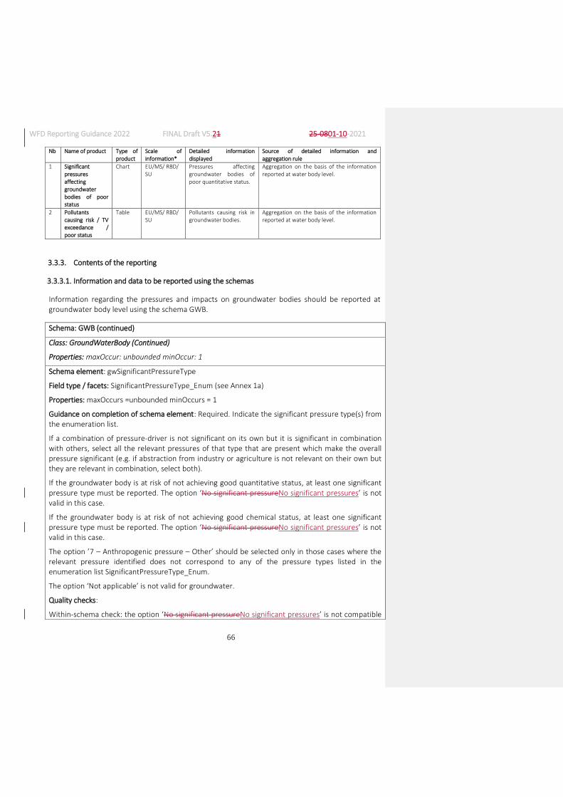
WFD Reporting Guidance 2022 FINAL Draft V5.21 25-0801-10-2021
66
Nb Name of product Type of product
Scale of information*
Detailed information displayed
Source of detailed information and aggregation rule
1 Significant pressures affecting groundwater bodies of poor status
Chart EU/MS/ RBD/ SU
Pressures affecting groundwater bodies of poor quantitative status.
Aggregation on the basis of the information reported at water body level.
2 Pollutants causing risk / TV exceedance / poor status
Table EU/MS/ RBD/ SU
Pollutants causing risk in groundwater bodies.
Aggregation on the basis of the information reported at water body level.
3.3.3. Contents of the reporting
3.3.3.1. Information and data to be reported using the schemas
Information regarding the pressures and impacts on groundwater bodies should be reported at groundwater body level using the schema GWB.
Schema: GWB (continued)
Class: GroundWaterBody (Continued)
Properties: maxOccur: unbounded minOccur: 1
Schema element: gwSignificantPressureType
Field type / facets: SignificantPressureType_Enum (see Annex 1a)
Properties: maxOccurs =unbounded minOccurs = 1
Guidance on completion of schema element: Required. Indicate the significant pressure type(s) from the enumeration list.
If a combination of pressure-driver is not significant on its own but it is significant in combination with others, select all the relevant pressures of that type that are present which make the overall pressure significant (e.g. if abstraction from industry or agriculture is not relevant on their own but they are relevant in combination, select both).
If the groundwater body is at risk of not achieving good quantitative status, at least one significant pressure type must be reported. The option ‘No significant pressureNo significant pressures’ is not valid in this case.
If the groundwater body is at risk of not achieving good chemical status, at least one significant pressure type must be reported. The option ‘No significant pressureNo significant pressures’ is not valid in this case.
The option ’7 – Anthropogenic pressure – Other’ should be selected only in those cases where the relevant pressure identified does not correspond to any of the pressure types listed in the enumeration list SignificantPressureType_Enum.
The option ‘Not applicable’ is not valid for groundwater.
Quality checks:
Within-schema check: the option ‘No significant pressureNo significant pressures’ is not compatible

WFD Reporting Guidance 2022 FINAL Draft V5.21 25-0801-10-2021
67
with any other.
Within-schema check: If GWB/GroundWaterBody/gwAtRiskQuantitative is ‘Yes’, at least one significant pressure type must be selected from the enumeration list (can include ‘8 Unknown pressures’). The option ‘No significant pressureNo significant pressures’ is not a valid selection in this case.
Within-schema check: If GWB/GroundWaterBody/gwAtRiskChemical is ‘Yes’, at least one significant pressure type must be selected from the enumeration list (can include ‘8 Unknown pressures’). The option ‘No significant pressureNo significant pressures’ is not a valid selection in this case.
The option ‘Not applicable’ is not valid.
Schema element: gwSignificantPressureOther
Field type / facets: String1000Type
Properties: maxOccurs =1 minOccurs = 0
Guidance on completion of schema element: Conditional. If ‘7 – Anthropogenic pressure – Other’ is reported under gwSignificantPressureType, provide details of any other anthropogenic pressure typess which are relevant in this element.
Quality checks: Conditional check: Report if and only if ‘7 – Anthropogenic pressure – Other’ is reported under gwSignificantPressureType.
Schema element: gwSignificantImpactType
Field type / facets: SignificantImpactType_Enum (see Annex 1b)
Properties: maxOccurs =unbounded minOccurs = 1
Guidance on completion of schema element: Required. Indicate the impact type(s) from the enumeration list.
If the groundwater body is at risk of not achieving good quantitative status, at least one significant impact type or the option ‘UNKN - Unknown impact type’ must be reported. The option ‘NOSI - No
significant impact’ is not valid in this case.
If the groundwater body is at risk of not achieving good chemical status, at least one significant impact type or the option ‘UNKN - Unknown impact type’ must be reported. The option ‘NOSI - No
significant impact’ is not valid in this case.
The option ‘OTHE – Other significant impact type’ should be selected only in those cases where the significant impact identified does not correspond to any of the impact types listed in the enumeration list SignificantImpactType_Enum.
The option ‘NOTA - Not applicable’ is not valid for groundwater.
Quality checks: Within-schema check: the option ‘NOSI - No significant impact’ is not compatible with any other.
Within-schema check: If GWB/GroundWaterBody/gwAtRiskQuantitative is ‘Yes’, at least one significant impact type must be selected from the enumeration list (can include option ‘UNKN -
Unknown impact type’). The option ‘NOSI - No significant impact’ is not a valid selection in this case.
Within-schema check: If GWB/GroundWaterBody/gwAtRiskChemical is ‘Yes’, at least one significant impact type must be selected from the enumeration list (can include option ‘UNKN - Unknown impact

WFD Reporting Guidance 2022 FINAL Draft V5.21 25-0801-10-2021
68
type’). The option ‘NOSI - No significant impact’ is not a valid selection.
The option ’NOTA - Not applicable’ is not valid.
Schema element: gwSignificantImpactOther
Field type / facets: String1000Type
Properties: maxOccurs =1 minOccurs = 0
Guidance on completion of schema element: Conditional. If ’OTHE - Other significant impact type’ is reported under gwSignificantImpactType, provide details of any other impact types which are relevant in this element.
Quality checks: Conditional check: Report if and only if ’OTHE - Other significant impact type’ is reported under gwSignificantImpactType.
3.3.3.2. Glossary: clarification of terms and reporting requirements
Some Member States which have a large number of groundwater bodies with low pressures may group groundwater bodies for the assessment of pressures and status. The information reported for the groundwater bodies belonging to a group will therefore be identical.
’Significant Pressures’ are those pressures which, either alone, or in combination with others prevent or put at risk the achievement of the Environmental Objectives in Article 4(1) of the WFD, including the achievement of good status, the non-deterioration of status, the avoidance of a significant and sustained upward trend in pollution of groundwater, and the achievement of objectives in WFD protected areas. This means that for the third RBMPs, all water bodies which are below good status and are not expected to achieve good status in 2021 are at risk and Member States are expected to identify significant pressures for them.
Pressures may combine to cause water bodies to be failing, or to be at risk of failing, WFD Environmental Objectives. The same happens when there are different pressures of the same type but caused by different drivers. For example abstraction for drinking water supply and for industry in a particular water body may not be significant on their own, but if they are significant when combined, they should both be identified as significant.
3.4. Quantitative status of groundwater and exemptions
3.4.1. Introduction
The WFD defines its Environmental Objectives in Article 4 and sets the aim for long term sustainable water management. Article 4(1) defines the WFD’s general objective to be achieved in all surface and groundwater bodies, i.e. good status (for natural water bodies) or potential (for Artificial or Heavily Modified Water Bodies) by 2015, and introduces the principle of preventing any further deterioration of status. A number of exemptions to the general objectives are possible under certain conditions.
Article 4(4) allows for an extension of the deadline beyond 2015.
Article 4(5) allows for the achievement of less stringent objectives.

WFD Reporting Guidance 2022 FINAL Draft V5.21 25-0801-10-2021
69
Article 4(6) allows a temporary deterioration in the status of water bodies.
Article 4(7) sets out conditions in which deterioration of status or failure to achieve certain of the WFD Environmental Objectives may be permitted for new modifications to the physical characteristics of surface water bodies, and deterioration from high to good status may be possible as a result of new sustainable human development activities.
Member States have to provide information in the RBMPs regarding these exemptions and their justification.
The WFD provides the general framework on exemptions but there is scope for differences in understanding and implementation. From the outset of implementation, it was clear that the use of exemptions needed to be explained further and the rules for application had to be made clearer. These clarifications can be found in the CIS Guidance Document No. 20: Exemptions to the Environmental Objectives32 published in 2009.
Annex V of the WFD specifies how Member States are to monitor groundwater, and present and report the results of the quantitative status assessment and the methodology used to classify groundwater bodies.
3.4.2. How will the European Commission and the EEA use the information reported?
Key indicators of the level of compliance with the WFD will be the proportion of groundwater bodies in good quantitative status in each RBD or Sub-unit, together with the number of groundwater bodies at risk of failing good quantitative status.
The majority of the data and information reported by Member States will be used for visualisation in maps, graphs and charts and for providing information to the public through WISE. Furthermore, the data and maps will provide a comparison of current status with what was reported in the previous RBMPs (e.g. showing whether the quantitative status improved with the implementation of the Programme of Measures). This means that the requested data and maps will be essential for trend analyses, for policy development and for the assessment of policy effectiveness.
Statistics and information will be provided to the European Parliament at EU level. Information will be provided to the public through WISE.
3.4.2.1. Products from reporting
The following list identifies some of the products which will be produced by the European Commission or the EEA from the data and information reported by Member States. For all relevant products, information on groundwater bodies will be presented by number and by size (area) as well as percentage.
32 CIS Guidance Document No. 20: Exemptions to the Environmental Objectives:
https://circabc.europa.eu/sd/a/2a3ec00a-d0e6-405f-bf66-60e212555db1/Guidance_documentN%C2%B020_Mars09.pdf
Nb Name of product Type of product
Scale of information*
Detailed information displayed
Source of detailed information and aggregation rule

WFD Reporting Guidance 2022 FINAL Draft V5.21 25-0801-10-2021
70
1 Number, area and percentage of groundwater bodies of good quantitative status and expected improvement
Table WB Number, area and percentage of groundwater bodies of good quantitative status and expected improvement since the first RBMPs.
Aggregation on the basis of the information provided at water body level.
2 Drivers responsible for failure of good quantitative status
Table RBD Number and area of groundwater bodies failing good quantitative status due to each driver.
Percentage of groundwater bodies failing good status due to each driver in relation to total number of groundwater bodies failing good status.
Aggregation on the basis of the information on pressures provided at water body level
3 Quantitative status of groundwater bodies
Chart National Percentage of groundwater bodies of poor and good quantitative status by area.
Aggregation on the basis of the information reported at water body level.
4 Quantitative status of groundwater bodies
Map RBD Percentage of groundwater bodies not achieving good quantitative status by area.
Aggregation on the basis of the information reported at water body level – water bodies with unknown status not included.
5 Aggregation tables: Quantitative and chemical status of groundwater bodies
Table MS/RBD Number and size (area) of groundwater bodies by quantitative status class.
Aggregation on the basis of the information reported at water body level.
6 Progress in achieving good quantitative status since the first RBMP
Map/ Chart
MS/RBD Number, area and percentage of groundwater bodies which have achieved good quantitative status since the first RBMPs.
Aggregation on the basis of the information reported at groundwater body level.
7 Improvement in quantitative status since the first RBMP
Map/ Chart
National/ RBD Percentage of water bodies which have improved quantitative status since the first RBMP
Aggregation on the basis of the information reported at water body level.
8 Reasons behind Article 4(4) exemptions
Chart MS Exemptions reported by Member States to extend the deadline of the achievement of good quantitative status beyond 2015 and reasons given (natural condition, technical feasibility, disproportionate costs or combinations).
Aggregation on the basis of the information reported at water body level.
9 Percentage of groundwater bodies expected to be of good quantitative status in 2015
Map/ Chart/ Table
EU/MS/ RBD Number, area and percentage of groundwater bodies expected to be of good quantitative status in 2015.
Aggregation on the basis of the information reported at water body level.

WFD Reporting Guidance 2022 FINAL Draft V5.21 25-0801-10-2021
71
Notes: * Scale of information: EU = European; MS = National, Member State; RBD = River Basin District; SU = Sub-unit; WB = water body
3.4.3. Contents of the reporting
3.4.3.1. Information and data to be reported using the schemas
Information regarding the quantitative status of groundwater bodies should be reported at groundwater body level using the schema GWB.
Schema: GWB (continued)
Class: GroundWaterBody (continued)
Properties: maxOccurs = unbounded minOccurs = 1
Schema element: gwAtRiskQuantitative
Field type / facets: YesNoCode_Enum: Yes, No
Properties: maxOccurs =1 minOccurs = 1
Guidance on completion of schema element: Required. Report whether the groundwater body is at risk of failing to be in good quantitative status.
Please follow the approach given in the ‘CIS Guidance Document No. 26: Risk assessment and the use of conceptual models’33.
Schema element: gwReasonsForRiskQuantitative
Field type / facets: QuantitativeFailure_Enum:
Water balance
Surface water
Groundwater-dependent terrestrial ecosystems
Saline or other intrusion
Properties: maxOccurs =unbounded minOccurs = 0
Guidance on completion of schema element: Conditional. If the groundwater body is at risk of failing to be in good quantitative status, select the reasons from the enumeration list.
‘Water balance’ = Exceedance of available groundwater resource by long-term annual average rate of abstraction, which may result in a decrease of groundwater level.
‘Surface water’ = Failure to achieve Environmental Objectives (Article 4 WFD) for associated surface water bodies, resulting from anthropogenic water level alteration or change in flow conditions; significant diminution of the status of surface waters resulting from anthropogenic water level alteration or change in flow conditions.
‘Groundwater-dependent terrestrial ecosystems’ = Significant damage to groundwater-dependent
33 CIS Guidance Document No. 26: Risk assessment and the use of conceptual models:
https://circabc.europa.eu/sd/a/8564a357-0e17-4619-bd76-a54a23fa7885/Guidance%20No%2026%20-%20GW%20risk%20assessment%20and%20conceptual%20models.pdf

WFD Reporting Guidance 2022 FINAL Draft V5.21 25-0801-10-2021
72
terrestrial ecosystems resulting from an anthropogenic water level alteration.
‘Saline or other intrusion’ = Regional saline or other intrusions resulting from anthropogenically induced sustained changes in flow direction.
Further guidance can be found in CIS Guidance Document 18: Groundwater Status and Trends Assessment34.
Quality checks: Conditional check: Report if and only if gwAtRiskQuantitative is ‘Yes’.
Schema element: gwEORiskQuantitative
Field type / facets: GWEORiskQuantitative_Enum:
Uses ofr functions
Surface waters / terrestrial ecosystems
Both
Properties: maxOccurs =1 minOccurs = 0
Guidance on completion of schema element: Conditional. If the groundwater body is at risk of failing to be in good quantitative status, select the Environmental Objective related to the risk from the enumeration list.
‘Uses or functions’ = The actual or potential legitimate uses or functions of the groundwater body.
‘Surface waters / terrestrial ecosystems’ = The relationship between groundwater bodies and the associated surface waters and directly dependent terrestrial ecosystems.
Quality checks: Conditional check: Report if and only if gwAtRiskQuantitative is ‘Yes’.
Schema element: gwQuantitativeStatusValue
Field type / facets: StatusCode_Enum: 2, 3, U
Properties: maxOccurs =1 minOccurs = 1
Guidance on completion of schema element: Required. Indicate the quantitative status of the groundwater body, based on the most recent assessment.
‘2’ = Good status.
‘3’ = Poor status.
‘U’ = Unknown status.
Schema element: gwQuantitativeReasonsForFailure
Field type / facets: QuantitativeFailure_Enum:
Water balance
Surface water
Groundwater-dependent terrestrial ecosystems
Saline or other intrusion
34 https://circabc.europa.eu/sd/a/8564a357-0e17-4619-bd76-a54a23fa7885/Guidance%20No%2026%20-
%20GW%20risk%20assessment%20and%20conceptual%20models.pdf

WFD Reporting Guidance 2022 FINAL Draft V5.21 25-0801-10-2021
73
Properties: maxOccurs =unbounded minOccurs = 0
Guidance on completion of schema element: Conditional. If the groundwater body is in poor quantitative status, select the reasons from the enumeration list:
‘Water balance’ = Exceedance of available groundwater resource by long-term annual average rate of abstraction, which may result in a decrease of groundwater levels.
‘Surface water’ = Failure to achieve Environmental Objectives (Article 4 WFD) for associated surface water bodies, resulting from anthropogenic water level alteration or change in flow conditions; significant diminution of the status of surface waters resulting from anthropogenic water level alteration or change in flow conditions.
‘Groundwater-dependent terrestrial ecosystems’ = Significant damage to groundwater-dependent terrestrial ecosystems resulting from an anthropogenic water level alteration.
‘Saline or other intrusion’ = Regional saline or other intrusions resulting from anthropogenically induced sustained changes in flow direction.
Further guidance can be found in CIS Guidance Document 18, ‘Groundwater Status and Trends Assessment’35.
Quality checks: Conditional check: Report if and only if gwQuantitativeStatusValue is ‘3’.
Schema element: gwQuantitativeAssessmentYear
Field type / facets: YearRangeType
Properties: maxOccurs =1 minOccurs = 1
Guidance on completion of schema element: Required. Provide the year on which the assessment of status is based. This may be the year when the groundwater body was monitored or, in case of grouping, the year in which monitoring took place in the groundwater bodies within the group that are used to extrapolate results to non-monitored groundwater bodies. It is possible to report a single year or a period (e.g. 2018--2020).
Schema element: gwQuantitativeAssessmentConfidence
Field type / facets: Confidence_Enum: 0, 1, 2, 3
Properties: maxOccurs =1 minOccurs = 1
Guidance on completion of schema element: Required. Indicate the confidence on the quantitative status assigned.
‘0’ = No information.
‘1’ = Low confidence (e.g. no monitoring data, or no conceptual model or understanding of the system).
‘2’ = Medium confidence (e.g. limited or insufficiently robust monitoring data and expert judgment plays a significant role in assessment of status).
‘3’ = High confidence (e.g. good monitoring data and a good conceptual model or understanding of the system based on information on its natural characteristics and its pressures).
35 https://circabc.europa.eu/sd/a/8564a357-0e17-4619-bd76-a54a23fa7885/Guidance%20No%2026%20-
%20GW%20risk%20assessment%20and%20conceptual%20models.pdf

WFD Reporting Guidance 2022 FINAL Draft V5.21 25-0801-10-2021
74
The criteria used by Member States to assess confidence vary considerably, but the above examples provide some general guidance.
For further information, please see CIS Guidance Document No. 7, ‘Monitoring under the Water Framework Directive’36 and CIS Guidance Document No. 15, ‘Groundwater monitoring’37.
Quality checks: Within-schema check: If gwQuantitativeStatusValue is ‘U’ (Unknown) then
gwQuantitativeAssessmentConfidence must be ‘0’
Schema element: gwQuantitativeStatusExpectedAchievementDate
Field type / facets: GoodStatus_Enum:
2021 or earlier
2022--2027
Beyond 2027
Unknown
Less stringent objectives already achieved
Properties: maxOccurs =1 minOccurs = 1
Guidance on completion of schema element: Required. Report the period in which good quantitative status is expected to be achieved. Select the option ‘2021 or ealier’ if good quantitative status has already been reached or is expected to be reached by 2021.
The methodology of this assessment should be clearly explained in the RBMP or background documents (reference reported under classification methodologies, see section 8.3).
If good quantitative status will not be achieved by 2021, exemptions have to be reported. Please report the period in which it is expected that good quantitative status will be achieved in full, not the date relating to individual exemptions. However, please note the following:
Article 4(4) exemptions relate to the extension of deadlines. According to Article 4(4)(c) of the WFD, postponing the achievement of objectives beyond 2027 is only possible due to natural conditions.
If Article 4(5) exemptions apply, report the period in which the less stringent objective is expected to be achieved. If the less stringent objective has already been achieved then select 'Less stringent objectives already achieved'.
Quality checks: Within-schema check: 'Less stringent objectives already achieved' is only a valid option if 'Article 4(5)…' is reported under gwQuantitativeExemptionType.
Schema element: gwQuantitativeExemptionType
Field type / facets: ExemptionType_Enum (see Annex 8g)
Properties: maxOccurs =unbounded minOccurs = 1
Guidance on completion of schema element: Required. Report which type(s) of exemption apply if
36 https://circabc.europa.eu/sd/a/63f7715f-0f45-4955-b7cb-58ca305e42a8/Guidance%20No%207%20-
%20Monitoring%20(WG%202.7).pdf 37 https://circabc.europa.eu/sd/a/e409710d-f1c1-4672-9480-
e2b9e93f30ad/Groundwater%20Monitoring%20Guidance%20Nov-2006_FINAL-2.pdf
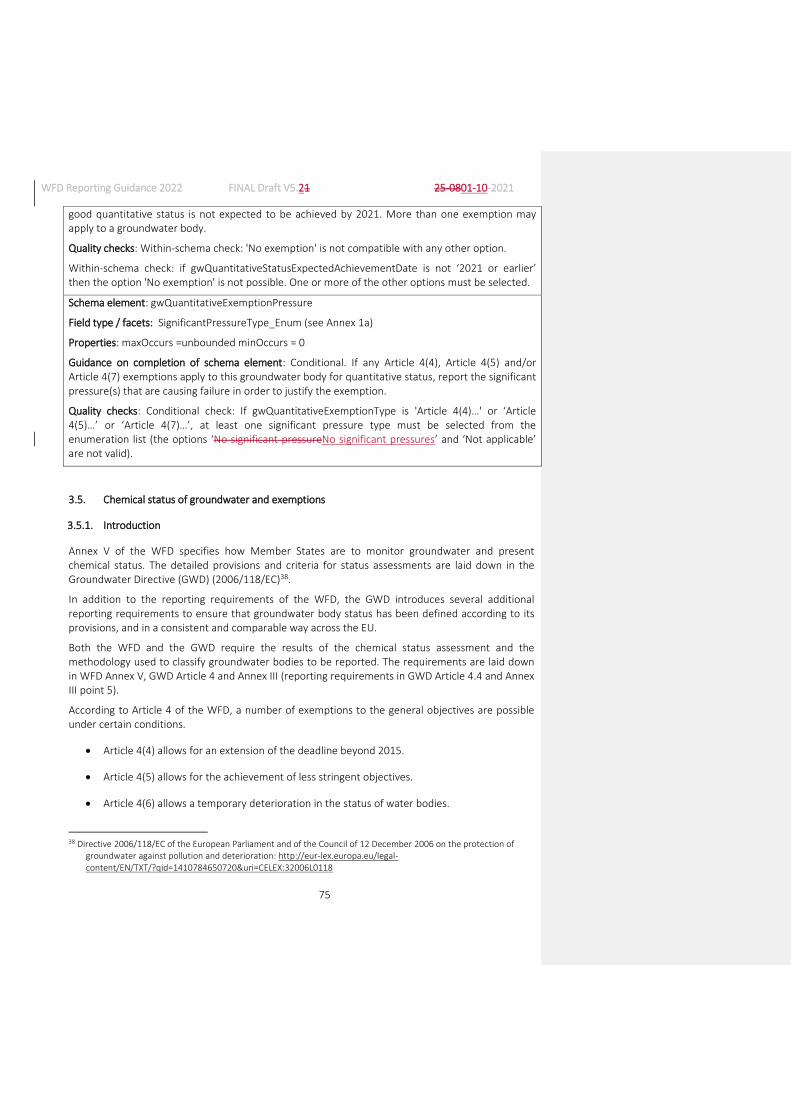
WFD Reporting Guidance 2022 FINAL Draft V5.21 25-0801-10-2021
75
good quantitative status is not expected to be achieved by 2021. More than one exemption may apply to a groundwater body.
Quality checks: Within-schema check: 'No exemption' is not compatible with any other option.
Within-schema check: if gwQuantitativeStatusExpectedAchievementDate is not ‘2021 or earlier’ then the option 'No exemption' is not possible. One or more of the other options must be selected.
Schema element: gwQuantitativeExemptionPressure
Field type / facets: SignificantPressureType_Enum (see Annex 1a)
Properties: maxOccurs =unbounded minOccurs = 0
Guidance on completion of schema element: Conditional. If any Article 4(4), Article 4(5) and/or Article 4(7) exemptions apply to this groundwater body for quantitative status, report the significant pressure(s) that are causing failure in order to justify the exemption.
Quality checks: Conditional check: If gwQuantitativeExemptionType is 'Article 4(4)…' or ‘Article 4(5)…’ or ‘Article 4(7)…’, at least one significant pressure type must be selected from the enumeration list (the options ‘No significant pressureNo significant pressures’ and ‘Not applicable’ are not valid).
3.5. Chemical status of groundwater and exemptions
3.5.1. Introduction
Annex V of the WFD specifies how Member States are to monitor groundwater and present chemical status. The detailed provisions and criteria for status assessments are laid down in the Groundwater Directive (GWD) (2006/118/EC)38.
In addition to the reporting requirements of the WFD, the GWD introduces several additional reporting requirements to ensure that groundwater body status has been defined according to its provisions, and in a consistent and comparable way across the EU.
Both the WFD and the GWD require the results of the chemical status assessment and the methodology used to classify groundwater bodies to be reported. The requirements are laid down in WFD Annex V, GWD Article 4 and Annex III (reporting requirements in GWD Article 4.4 and Annex III point 5).
According to Article 4 of the WFD, a number of exemptions to the general objectives are possible under certain conditions.
Article 4(4) allows for an extension of the deadline beyond 2015.
Article 4(5) allows for the achievement of less stringent objectives.
Article 4(6) allows a temporary deterioration in the status of water bodies.
38 Directive 2006/118/EC of the European Parliament and of the Council of 12 December 2006 on the protection of
groundwater against pollution and deterioration: http://eur-lex.europa.eu/legal-content/EN/TXT/?qid=1410784650720&uri=CELEX:32006L0118

WFD Reporting Guidance 2022 FINAL Draft V5.21 25-0801-10-2021
76
Article 4(7) sets out conditions in which deterioration of status or failure to achieve certain of the WFD Environmental Objectives may be permitted for new modifications to the physical characteristics of surface water bodies, and deterioration from high to good status may be possible as a result of new sustainable human development activities.
Member States have to provide information in the RBMPs regarding these exemptions and their justification.
The WFD provides the general framework on exemptions but there is scope for differences in understanding and implementation. From the outset of implementation, it was clear that the use of exemptions needed to be explained further and the rules for application had to be made clearer. These clarifications can be found in the CIS Guidance Document No. 20: Exemptions to the Environmental Objectives39 published in 2009.
Articles 4(4) to 4(7) of the WFD allow Member States to extend the deadlines for the achievement of good status or to set other objectives under certain specified circumstances. Additional information can be found in the CIS Guidance Document No. 20: Exemptions to the Environmental Objectives40 agreed in 2005.
3.5.2. How will the European Commission and the EEA use the information reported?
The information reported by Member States will be used to establish the key indicator on the percentage of groundwater bodies in good chemical status, together with the number of groundwater bodies at risk of not achieving good chemical status. The majority of the reported information will be used for visualisation in maps, graphs and charts and for providing information to the public through WISE. Furthermore, the data and maps will provide a comparison of current status with what was reported in the previous RBMPs (e.g. showing whether the chemical status improved with the implementation of the Programmes of Measures). This means that the requested data and maps will be essential for trend analyses, for policy development and for the assessment of policy effectiveness.
Statistics and information will be provided to the European Parliament at EU level. Information will be provided to the public through WISE.
3.5.2.1. Products from reporting
The following list identifies some of the products which will be produced by the European Commission or the EEA from the data and information reported by Member States. For all relevant products, information on groundwater bodies will be presented by number of groundwater bodies and by size (area) as well as percentage.
Nb Name of product Type of product
Scale of information*
Detailed information displayed
Source of detailed information and aggregation rule
39 CIS Guidance Document No. 20: Exemptions to the Environmental Objectives:
https://circabc.europa.eu/sd/a/2a3ec00a-d0e6-405f-bf66-60e212555db1/Guidance_documentN%C2%B020_Mars09.pdf
40 CIS Guidance Document No. 20: Exemptions to the Environmental Objectives: https://circabc.europa.eu/sd/a/2a3ec00a-d0e6-405f-bf66-60e212555db1/Guidance_documentN%C2%B020_Mars09.pdf

WFD Reporting Guidance 2022 FINAL Draft V5.21 25-0801-10-2021
77
1 Number, area and percentage of groundwater bodies of good chemical status and expected improvement
Table WB Number, area and percentage of groundwater bodies of good chemical status and expected improvement since the first RBMPs.
Aggregation on the basis of the information provided at water body level.
2 Drivers responsible for failure of good chemical status
Table RBD/SU Number and area of groundwater bodies failing good chemical status due to each driver.
Percentage of groundwater bodies failing good chemical status due to each driver in relation to total number of groundwater bodies failing good status.
Aggregation on the basis of the information on pressures provided at water body level.
3 Chemical status of groundwater bodies
Chart MS Percentage of groundwater bodies of poor and good chemical status by area.
Aggregation on the basis of the information reported at water body level – water bodies with unknown status not included
4 Chemical status of groundwater bodies
Map RBD Percentage of groundwater area not achieving good chemical status.
Aggregation on the basis of the information reported at water body level – water bodies with unknown status not included.
5 Percentage of groundwater bodies not achieving good chemical status due to nitrate
Map RBD Percentage of groundwater body area not achieving good chemical status due to nitrate
Aggregation on the basis of the information reported at water body level – water bodies with unknown status not included.
6 Aggregation tables: Quantitative and chemical status of groundwater bodies
Table MS/ RBD/SU Number and size (area) of groundwater bodies by chemical status class.
Aggregation on the basis of the information reported at water body level.
7 Progress in achieving good chemical status since the first RBMP
Map/ Chart
MS/ RBD/SU Number, area and percentage of water bodies which have achieved good chemical status since the first RBMPs.
Aggregation on the basis of the information reported at water body level.
8 Improvement in chemical status since the first RBMP
Map/ Chart
MS/ RBD/SU Percentage of water bodies which have improved status since the first RBMP
Aggregation on the basis of the information reported at water body level.
9 Reasons behind Article 4(4) exemptions
Chart MS Exemptions reported by Member States to extend the deadline of the achievement of good status beyond 2015 and reasons given (natural condition, technical feasibility, disproportionate costs or combinations).
Aggregation on the basis of the information reported at water body level.
10 Instances where Article 4(2)c of the Groundwater Directive has been applied
Chart MS/ RBD/SU Number of groundwater bodies in which exceedances of quality standards and/or threshold values do not result in a failure of good chemical status
Aggregation on the basis of the information reported at water body level.

WFD Reporting Guidance 2022 FINAL Draft V5.21 25-0801-10-2021
78
11 Percentage of groundwater bodies expected to be of good chemical status in 2015
Map/ Chart/ Table
EU/MS/RBD/ SU
Number, area and percentage of groundwater bodies expected to be of good chemical status in 2015.
Aggregation on the basis of the information reported at water body level.
12 Percentage of groundwater bodies at risk
Map/ Chart/ Table
EU/MS/RBD/ SU
Percentage of groundwater bodies at risk.
Aggregation on the basis of the information reported at water body level.
13 Percentage of groundwater bodies subject to an environmentally significant and sustained anthropogenically induced upward trend
Map/ Chart/ Table
EU/MS/RBD/ SU
Percentage of groundwater bodies showing a significant and sustained anthropogenically induced upward trend
Aggregation on the basis of the information reported at water body level.
Notes: * Scale of information: EU = European; MS = National, Member State; RBD = River Basin District; SU = Sub-unit; WB = water body; Site = monitoring site
3.5.3. Contents of the reporting
3.5.3.1. Information and data to be reported using the schemas
Information regarding the chemical status of groundwater bodies should be reported at groundwater body level using the schema GWB.
Schema: GWB (continued)
Class: GroundWaterBody (continued)
Properties: maxOccurs = unbounded minOccurs = 1
Schema element: gwAtRiskChemical
Field type / facets: YesNoCode_Enum: Yes, No
Properties: maxOccurs =1 minOccurs = 1
Guidance on completion of schema element: Required. Report whether the groundwater body is at risk of failing to be in good chemical status.
The identification of groundwater bodies at risk should follow the approach given in the CIS Guidance Document No. 26, ‘Risk assessment and the use of conceptual models’41.
Quality checks: Within-schema check: ‘Yes’ has to be selected if GWPollutant/gwPollutantCausingRisk is ‘Yes’ for at least one pollutant or indicator of pollution.
Schema element: gwEORiskChemical
Field type / facets: EORiskChemical_Enum:
Uses ofr functions
Surface waters / terrestrial ecosystems
41 CIS Guidance Document No. 26: Risk assessment and the use of conceptual models:
https://circabc.europa.eu/sd/a/8564a357-0e17-4619-bd76-a54a23fa7885/Guidance%20No%2026%20-%20GW%20risk%20assessment%20and%20conceptual%20models.pdf

WFD Reporting Guidance 2022 FINAL Draft V5.21 25-0801-10-2021
79
Both
Properties: maxOccurs =1 minOccurs = 0
Guidance on completion of schema element: Conditional. If the groundwater body is at risk of failing to be in good chemical status, select from the enumeration list the Environmental Objective to which the risk is related:
‘Uses or functions’ = The risk is related to the actual or potential legitimate uses or functions of the groundwater body.
‘Surface waters / terrestrial ecosystems’ = The risk is related to the relationship between groundwater bodies and the associated surface waters and directly dependent terrestrial ecosystems.
‘Both’ = The risk is related to both objectives above.
Further guidance can be found in CIS Guidance Document no. 18, ‘Groundwater Status and Trends Assessment’42.
Quality checks: Conditional check: Report if and only if gwAtRiskChemical is ‘Yes’.
Schema element: gwChemicalStatusValue
Field type / facets: StatusCode_Enum: 2, 3, U
Properties: maxOccurs =1 minOccurs = 1
Guidance on completion of schema element: Required. Indicate the chemical status of the groundwater body.
‘2’ = Good status.
‘3’ = Poor status.
‘U’ = Unknown status.
Quality checks: Within-schema check: ‘3’ has to be selected if GWPollutant/gwPollutantCausingFailure is ‘Yes’ for at least one pollutant or indicator of pollution.
Schema element: gwChemicalReasonsForFailure
Field type / facets: ReasonsForFailure_Enum:
Surface water
Groundwater-dependent terrestrial ecosystems
Saline or other intrusion
Drinking Water Protected Area
General water quality assessment
Properties: maxOccurs =unbounded minOccurs = 0
Guidance on completion of schema element: Conditional. If the groundwater body is in poor chemical status, select the reasons from the enumeration list:
42 https://circabc.europa.eu/sd/a/8564a357-0e17-4619-bd76-a54a23fa7885/Guidance%20No%2026%20-
%20GW%20risk%20assessment%20and%20conceptual%20models.pdf
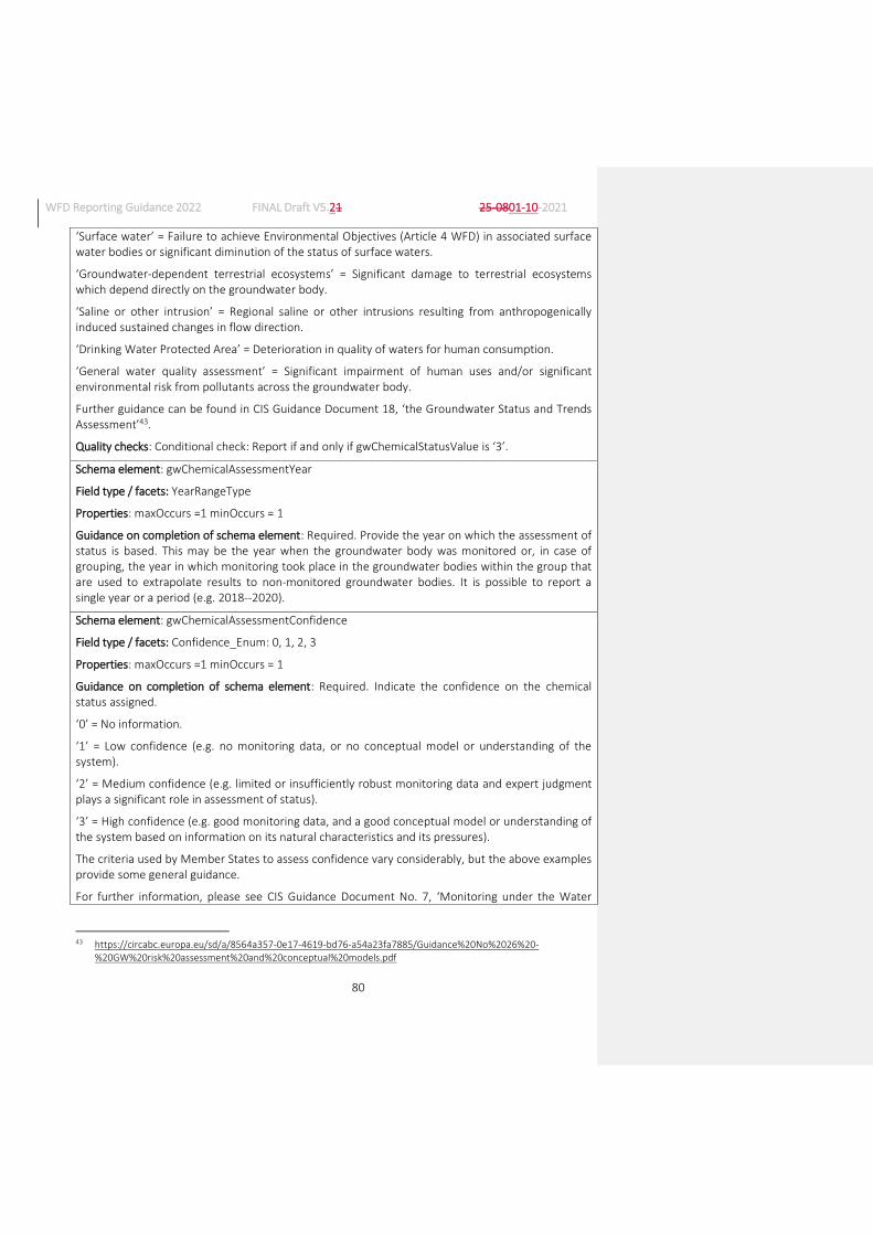
WFD Reporting Guidance 2022 FINAL Draft V5.21 25-0801-10-2021
80
‘Surface water’ = Failure to achieve Environmental Objectives (Article 4 WFD) in associated surface water bodies or significant diminution of the status of surface waters.
‘Groundwater-dependent terrestrial ecosystems’ = Significant damage to terrestrial ecosystems which depend directly on the groundwater body.
‘Saline or other intrusion’ = Regional saline or other intrusions resulting from anthropogenically induced sustained changes in flow direction.
‘Drinking Water Protected Area’ = Deterioration in quality of waters for human consumption.
‘General water quality assessment’ = Significant impairment of human uses and/or significant environmental risk from pollutants across the groundwater body.
Further guidance can be found in CIS Guidance Document 18, ‘the Groundwater Status and Trends Assessment’43.
Quality checks: Conditional check: Report if and only if gwChemicalStatusValue is ‘3’.
Schema element: gwChemicalAssessmentYear
Field type / facets: YearRangeType
Properties: maxOccurs =1 minOccurs = 1
Guidance on completion of schema element: Required. Provide the year on which the assessment of status is based. This may be the year when the groundwater body was monitored or, in case of grouping, the year in which monitoring took place in the groundwater bodies within the group that are used to extrapolate results to non-monitored groundwater bodies. It is possible to report a single year or a period (e.g. 2018--2020).
Schema element: gwChemicalAssessmentConfidence
Field type / facets: Confidence_Enum: 0, 1, 2, 3
Properties: maxOccurs =1 minOccurs = 1
Guidance on completion of schema element: Required. Indicate the confidence on the chemical status assigned.
‘0’ = No information.
‘1’ = Low confidence (e.g. no monitoring data, or no conceptual model or understanding of the system).
‘2’ = Medium confidence (e.g. limited or insufficiently robust monitoring data and expert judgment plays a significant role in assessment of status).
‘3’ = High confidence (e.g. good monitoring data, and a good conceptual model or understanding of the system based on information on its natural characteristics and its pressures).
The criteria used by Member States to assess confidence vary considerably, but the above examples provide some general guidance.
For further information, please see CIS Guidance Document No. 7, ‘Monitoring under the Water
43 https://circabc.europa.eu/sd/a/8564a357-0e17-4619-bd76-a54a23fa7885/Guidance%20No%2026%20-
%20GW%20risk%20assessment%20and%20conceptual%20models.pdf
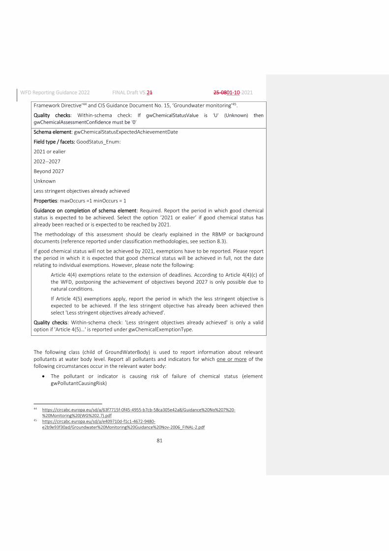
WFD Reporting Guidance 2022 FINAL Draft V5.21 25-0801-10-2021
81
Framework Directive’44 and CIS Guidance Document No. 15, ‘Groundwater monitoring’45.
Quality checks: Within-schema check: If gwChemicalStatusValue is ‘U’ (Unknown) then
gwChemicalAssessmentConfidence must be ‘0’
Schema element: gwChemicalStatusExpectedAchievementDate
Field type / facets: GoodStatus_Enum:
2021 or ealier
2022--2027
Beyond 2027
Unknown
Less stringent objectives already achieved
Properties: maxOccurs =1 minOccurs = 1
Guidance on completion of schema element: Required. Report the period in which good chemical status is expected to be achieved. Select the option ‘2021 or ealier’ if good chemical status has already been reached or is expected to be reached by 2021.
The methodology of this assessment should be clearly explained in the RBMP or background documents (reference reported under classification methodologies, see section 8.3).
If good chemical status will not be achieved by 2021, exemptions have to be reported. Please report the period in which it is expected that good chemical status will be achieved in full, not the date relating to individual exemptions. However, please note the following:
Article 4(4) exemptions relate to the extension of deadlines. According to Article 4(4)(c) of the WFD, postponing the achievement of objectives beyond 2027 is only possible due to natural conditions.
If Article 4(5) exemptions apply, report the period in which the less stringent objective is expected to be achieved. If the less stringent objective has already been achieved then select 'Less stringent objectives already achieved'.
Quality checks: Within-schema check: 'Less stringent objectives already achieved' is only a valid option if 'Article 4(5)…' is reported under gwChemicalExemptionType.
The following class (child of GroundWaterBody) is used to report information about relevant pollutants at water body level. Report all pollutants and indicators for which one or more of the following circumstances occur in the relevant water body:
The pollutant or indicator is causing risk of failure of chemical status (element gwPollutantCausingRisk)
44 https://circabc.europa.eu/sd/a/63f7715f-0f45-4955-b7cb-58ca305e42a8/Guidance%20No%207%20-
%20Monitoring%20(WG%202.7).pdf 45 https://circabc.europa.eu/sd/a/e409710d-f1c1-4672-9480-
e2b9e93f30ad/Groundwater%20Monitoring%20Guidance%20Nov-2006_FINAL-2.pdf

WFD Reporting Guidance 2022 FINAL Draft V5.21 25-0801-10-2021
82
The pollutant or indicator is causing failure of chemical status due to exceedance of the relevant EQS or threshold value (element gwPollutantCausingFailure)
The pollutant or indicator is showing an upward trend (element gwPollutantUpwardTrend )
The pollutant or indicator is showing a trend reversal (element gwPollutantTrendReversal )
The pollutant or indicator is showing exceedance(s) of the EQS or threshold value but, after an appropriate investigation according to Article 4(2)(c) and Annex III of the Groundwater Directive, the Member State considers that this does not result in a failure of chemical status (element gwPollutantExcedancesNotCounted)
Background levels have been set for the pollutant or indicator (elements gwPollutantBackgroundLevelSet, gwPollutantBackgroundLevelValue and gwPollutantBackgroundLevelUnit)
Schema: GWB (continued)
Class: GWPollutant
Properties: maxOccurs =unbounded minOccurs = 0
Schema element: gwPollutantCode
Field type / facets: ChemicalSubstances_Union_Enum (see Annex 8e)
Properties: maxOccurs = 1 minOccurs = 1
Guidance on completion of schema element: Required46. Select from the enumeration list each pollutant or indicator for which one or more of the following circumstances occur in the relevant water body:
- The pollutant or indicator is causing risk of failure of chemical status
- The pollutant or indicator is causing failure of chemical status due to exceedance of the relevant EQS or threshold value
- The pollutant or indicator is showing an upward trend
- The pollutant or indicator is showing a trend reversal
- The pollutant or indicator is showing exceedance(s) of the EQS or threshold value but, after an appropriate investigation according to Article 4(2)(c) and Annex III of the Groundwater Directive, the Member State considers that this does not result in a failure of chemical status
- Background levels have been set for the pollutant or indicator
‘EEA_00-00-0 – Other chemical parameter’ must be reported only when the failing RBSP is not included in the enumeration list RBSP_Enum.
Schema element: gwPollutantOther
Field type / facets: string250Type
Properties: maxOccurs = 1 minOccurs = 0
46 Please note that the multiplicity of the Class GWPollutant is 0 to many. Therefore, if there are no pollutants or
indicators to report for the relevant water body, this whole class does not need to be reported.

WFD Reporting Guidance 2022 FINAL Draft V5.21 25-0801-10-2021
83
Guidance on completion of schema element: Conditional. If gwPollutantCode is ‘EEA_00-00-0 Other chemical parameter’ please indicate in this field the CAS number (if relevant) and the name of the pollutant or indicator.
Quality check: Conditional check: report if and only if gwPollutantCode is ‘EEA_00-00-0 Other chemical parameter’.
Schema element: gwPollutantCausingRisk
Field type / facets: YesNoUnknownUnclear_Union_Enum: Yes, No, Unknown, Unclear
Properties: maxOccurs =1 minOccurs = 1
Guidance on completion of schema element: Required. Indicate whether the pollutant or indicator of pollution is causing risk of the groundwater body failing to be in good chemical status.
Quality checks: Within-schema check: If GroundWaterBody/gwAtRiskChemical is ‘Yes’ then at least one pollutant or indicator of pollution should be reported as ‘Yes’.
Schema element: gwPollutantCausingFailure
Field type / facets: YesNoCode_Enum: Yes, No
Properties: maxOccurs =1 minOccurs = 1
Guidance on completion of schema element: Required. Indicate whether the pollutant or indicator of pollution is causing failure to achieve good chemical status.
Quality checks: Within-schema check: If GroundWaterBody/gwChemicalStatusValue is ‘3’ then at least one pollutant or indicator of pollution should be reported as ‘Yes’.
Schema element: gwPollutantUpwardTrend
Field type / facets: YesNoUnknownUnclear_Union_Enum: Yes, No, Unknown/unclear
Properties: maxOccurs =1 minOccurs = 1
Guidance on completion of schema element: Required. Indicate whether there is a significant and sustained upward trend in the concentration of the pollutant or indicator of pollution.
Schema element: gwPollutantTrendReversal
Field type / facets: YesNoUnknownNotApplicableCode_Enum: Yes, No, Unknown, Not applicable
Properties: maxOccurs =1 minOccurs = 1
Guidance on completion of schema element: Required. Indicate whether there is a trend reversal in the concentration of the pollutant or indicator of pollution. Report ‘Not applicable’ if there is no significant and sustained upward trend in the concentration of the pollutant or indicator of pollution.
Quality checks: Within-schema check: the option 'Not applicable' is only valid if gwPollutantUpwardTrend is 'No'.
Schema element: gwPollutantTrendReversalProcess
Field type / facets: YesNoNotApplicable_Union_Enum: Yes, No, Not applicable
Properties: maxOccurs =1 minOccurs = 1
Guidance on completion of schema element: Required. If there is a significant and sustained upward trend in the concentration of the pollutant or indicator of pollution, indicate whether there is a
WFD Reporting Guidance 2022 FINAL Draft V5.21 25-0801-10-2021
84
process in place that will lead to a trend reversal. Report ‘Not applicable’ if there is no significant and sustained upward trend in the concentration of the pollutant or indicator of pollution.
Quality checks: Within-schema check: the option 'Not applicable' is only valid if gwPollutantUpwardTrend is 'No'.
Schema element: gwPollutantsExceedancesNotCounted
Field type / facets: YesNoUnknownCode_Enum: Yes, No Unknown
Properties: maxOccurs =1 minOccurs = 1
Guidance on completion of schema element: Required. Indicate whether there are exceedances of the pollutant or indicator of pollution which are not considered as failures to achieve good chemical status (according to Article 4(2)(c) of the GWD).
Schema element: gwPollutantBackgroundLevelSet
Field type / facets: YesNoCode_Enum: Yes, No
Properties: maxOccurs =1 minOccurs = 1
Guidance on completion of schema element: Required. Indicate whether a background level of natural substances has been set.
Schema element: gwPollutantBackgroundLevelValue
Field type / facets: String100Type
Properties: maxOccurs =1 minOccurs = 0
Guidance on completion of schema element: Conditional. If a background level is set, report the numeric value or range of the natural background level.
Quality checks: Conditional check: report if and only if ‘gwPollutantBackgroundLevelSet’ is ‘Yes’.
Schema element: gwPollutantBackgroundLevelUnit
Field type / facets: UnitOfMeasure_Enum (see Annex 8f)
Properties: maxOccurs =1 minOccurs = 0
Guidance on completion of schema element: Conditional. If a background level is set, select the relevant units for the natural background concentrations or levels.
Quality checks: Conditional check: report if and only if ‘gwPollutantBackgroundLevelSet’ is ‘Yes’.
The following class (child of GWPollutant) is used to report exemptions at pollutant or indicator of pollution level. This class has to be reported for all pollutants or indicators of pollution causing failure to reach good chemical status.
More than one exemption may apply to a pollutant and a groundwater body. The full class has to be reported once for each exemption applied.
Schema: GWB (continued)
Class: GWChemicalExemptionType

WFD Reporting Guidance 2022 FINAL Draft V5.21 25-0801-10-2021
85
Properties; max Occur: unbounded minOccur: 0
Conditional: report if ‘gwPollutantCausingFailure’ is ‘Yes’.
Schema element: gwChemicalExemptionType
Field type / facets: GWChemicalExemptionType_Union_Enum (see Annex 8g)
Properties: maxOccurs = 1 minOccurs = 1
Guidance on completion of schema element: Required. Report which type(s) of exemption apply if good chemical status is not expected to be achieved by 2021 for the pollutant or indicator of pollution being reported.
Article 4(7) exemptions are not relevant for good chemical status and therefore cannot be reported.
Quality checks: Within-schema check: The option 'No exemption' is not compatible with any other.
The options ‘Article4(7) - New modification’ and ‘Article4(7) - Sustainable human development’ are not valid options.
Schema element: gwChemicalExemptionPressure
Field type / facets: SignificantPressureType_Enum (see Annex 1a)
Properties: maxOccurs = 1 minOccurs = 1
Guidance on completion of schema element: Conditional. If any GWD Article 6(3) or WFD Article 4(4) or 4(5) exemptions apply to this groundwater body for chemical status, report the significant pressure(s) that are causing failure in order to justify the exemption.
Quality checks: Conditional check: If gwChemicalExemptionType is ‘GWD Article 6(3)…’, 'Article 4(4)…' or ‘Article 4(5)…’,, at least one significant pressure type must be selected from the enumeration list.
The options ‘No significant pressureNo significant pressures’ and ‘Not applicable’ are not valid.
4. MONITORING (SCHEMA MONITORING)
4.1. Introduction
Article 8.1 of the WFD requires Member States to establish monitoring programmes for the assessment of the status of surface water and of groundwater in order to provide a coherent and comprehensive overview of water status within each RBD. These requirements include monitoring of Protected Areas as far as the status of surface water and groundwater is concerned. The results of monitoring play a key role in determining whether water bodies are of good status and what measures need to be included in the RBMPs in order to reach good status. Precise and reliable monitoring results are therefore a prerequisite for sound planning of investments in the Programmes of Measures (PoMs).
The WFD implementation reports required by Article 18 of the WFD should include, among other aspects, ‘a review of the status of surface water and groundwater in the Community undertaken in co-ordination with the European Environment Agency’. In the first implementation report, this review was based on both the State of the Environment (SoE) information provided by EEA Member Countries through the EIONET reporting process, and the status and pressure results reported at

WFD Reporting Guidance 2022 FINAL Draft V5.21 25-0801-10-2021
86
water body level by Member States under the WFD. Streamlining between WFD and SoE reporting is improving, to ensure the most beneficial outcome of this two-level approach.
Reporting should reflect the monitoring that was carried out and informed the third RBMPs. It is not intended to include information regarding future monitoring programmes. It can include planned changes when sufficient information is already available on the QEs, substances or parameters that will be monitored and at which frequency. In these cases, the date of the last monitoring should be reported as ‘9999’, as mentioned in the specific guidance below.
The selection of the quality elements (QEs) and parameters to be monitored should enable the detection of all significant pressures on water bodies. This is particularly important where the pressures and impacts assessments may not have been sufficient to identify all potential pressures and impacts in the RBD, because of the lack of information or methods, or because of unexpected, anthropogenic activities within the RBD.
The results of surveillance monitoring should ensure that the potential impacts of all pressures on water bodies in the RBDs are detected. Incomplete coverage of QEs and water bodies in surveillance monitoring could lead to the non-detection of significant pressures, the incorrect classification of water status and inappropriate targeting of measures. Surveillance monitoring must also be able to detect long-term natural changes and changes arising from anthropogenic pressures.
The selection of biological quality elements (BQEs) for operational monitoring should focus on those most sensitive to the identified pressures and impacts on water bodies. The results of operational monitoring are used (together with the results of surveillance monitoring) in the classification of water bodies and to monitor progress of implemented measures in achieving the objectives of the Directive.
The results of monitoring are used in the assessment and classification of the status of water bodies (ecological and chemical for surface waters, chemical and quantitative for groundwater). The amount of monitoring undertaken in terms of QEs, parameters, frequency and numbers of monitoring sites should be sufficient to obtain a reliable and robust assessment of the status of all water bodies in the RBDs. Insufficient monitoring leads to a low confidence in the classification of water bodies and, as a result, the (expensive) measures required to achieve objectives may be incorrectly targeted, and/or objectives such as the restoration of water bodies to good status may not be achieved.
Directive 2009/90/EC47 lays down technical specifications for the chemical analysis and monitoring of water status with the aim of improving the quality and comparability of monitoring results by establishing minimum performance criteria for methods of analysis to be applied by Member States when monitoring water status, sediment and biota, as well as rules for demonstrating the quality of analytical results.
47 http://eur-lex.europa.eu/legal-content/EN/TXT/?qid=1411979700659&uri=CELEX:32009L0090

WFD Reporting Guidance 2022 FINAL Draft V5.21 25-0801-10-2021
87
4.2. How will the European Commission and the EEA use the information reported?
The European Commission will check comparability of the monitoring programmes between Member States and consistency with the requirements of Annex V of the WFD and the outcome of the Article 5 analysis. Moreover, the European Commission will use this information to inform the European Parliament and the public about progress in the Member States in the implementation of the WFD. Finally, some of the base data are necessary to update a reference dataset with which monitoring results can be related and exchanged between the Member States and the European institutions more easily at a later stage.
Data on water quality, including from monitoring BQEs and Priority Substances, will be used by the EEA in producing trend assessments and overviews of the status of, and pressures affecting, Europe’s surface waters and groundwater. The assessment of information reported in the third RBMPs will focus on illustrating improvement in status and progress made in reducing pressures.
The wealth of information already reported by EEA Member Countries (including EU Member States) on water quality and BQEs via the EIONET water priority data flows (WISE-SoE) can be most effectively interpreted when streamlined with the WFD reporting. In the context of the implementation of the SEIS principles48, monitoring results from the EIONET water monitoring sites which are also, in the main, WFD surveillance monitoring sites, can be used in the mutual exchange of information between the SoE and WFD assessments and provide a common basis for the assessment of status and pressures. The SoE assessments can be further enhanced with monitoring results from WFD operational monitoring sites.
Statistics and information will be provided to the European Parliament at EU level. Information will be provided to the public through WISE.
4.2.1. Products from reporting
The following list identifies some of the products which will be produced by the European Commission or the EEA from the data and information reported by Member States.
Nb Name of product
Type of pro-duct
Scale of infor-ma-tion*
Detailed information displayed
Source of detailed information and aggregation rule
1 Surface water monitoring sites
Map Site Map of surface water monitoring sites by Category.
Geographical location of monitoring sites as reported.
2 Number of surveillance, operational and total monitoring sites by water category
Table MS Number of surveillance, operational and total monitoring sites per surface water Category. Number of surveillance, operational and quantitative monitoring sites for groundwater.
Aggregation on the basis of the information reported at monitoring site level.
48 SEIS – shared environmental information systems – collect once use multiple times

WFD Reporting Guidance 2022 FINAL Draft V5.21 25-0801-10-2021
88
3 Number of surveillance and operational monitoring sites per 1000 km2
Chart MS Number of surveillance and operational monitoring sites per 1000 km2
Aggregation on the basis of the information reported at monitoring site level and total surface area of the RBD.
4 Number of monitoring sites in surface waters used for monitoring the different types of quality elements
Table MS Number of monitoring sites in surface waters used for monitoring the different types of quality elements (biological; hydromorphological; physico-chemical including non-priority specific pollutants; Priority Substances).
Aggregation on the basis of the information reported at monitoring site level.
5 Percentage of surface water bodies included in surveillance monitoring compared to total number of surface water bodies
Chart MS Percentage of surface water bodies included in surveillance monitoring compared to total number of surface water bodies.
Aggregation on the basis of the water body information reported at monitoring site level.
6 Number of river water bodies included in surveillance monitoring
Chart MS Number of river water bodies included in surveillance monitoring, benchmarked to criteria in WFD Annex V Section 1.3.1.
Aggregation on the basis of the water body information reported at monitoring site level. Benchmark is MS land area divided by 2500 km2.
7 Percentage of surface water bodies in surveillance monitoring in which all relevant biological quality elements are monitored
Chart MS Percentage of surface water bodies in surveillance monitoring in which all relevant biological quality elements are monitored.
Aggregation on the basis of the water body information reported at monitoring site level.
8 Percentage of surface water bodies included in operational monitoring compared to surface water bodies with significant pressures
Chart MS Percentage of surface water bodies included in operational monitoring and compared to surface water bodies with significant pressures.
Aggregation on the basis of the water body information reported at monitoring site level.

WFD Reporting Guidance 2022 FINAL Draft V5.21 25-0801-10-2021
89
9 Percentage of surface water bodies included in operational monitoring compared to total failing good ecological status
Chart MS Percentage of surface water bodies included in operational monitoring compared to total number of surface water bodies failing to achieve good ecological status.
Aggregation on the basis of the water body information reported at monitoring site and at water body level.
10 Number of operational sites in relation to the population density of the Member State
Chart MS Number of operational sites in relation to the population density of the Member State; population density is used as an indicator of the amount of potential pressure from human activity.
Aggregation on the basis of the water body information reported at monitoring site level.
11 Percentage of surface water bodies included in operational monitoring in which each biological quality element is measured
Chart MS Percentage of surface water bodies included in operational monitoring in which phytoplankton, other aquatic flora, macroinvertebrates and fish are monitored.
Aggregation on the basis of the water body information reported at monitoring site level.
12 Percentage of surface water bodies monitored and classified (on the basis of monitoring or extrapolation) for chemical status
Chart MS Percentage of surface water bodies classified for chemical status compared to the percentage of water bodies monitored for Priority Substances.
Aggregation on the basis of information reported at water body and monitoring site levels.
13 Percentage of surface water bodies in which each Priority Substance is monitored
Chart MS Percentage of surface water bodies in which each Priority Substance is monitored.
Aggregation on the basis of information reported at water body and monitoring site levels.
14 Number of surface water monitoring sites per Priority Substance
Chart or table
EU/MS/ RBD/SU
Number of monitoring sites per Priority Substance differentiating matrix and purpose (status and trend).
Aggregation on the basis of the water body information reported at monitoring site level.
15 Number of Priority Substances reliably monitored in surveillance and/or operational monitoring
Chart MS Number of Priority Substances monitored in accordance with QA/QC Directive performance requirements in surveillance and/or operational monitoring.
Aggregation of information reported at RBD level.

WFD Reporting Guidance 2022 FINAL Draft V5.21 25-0801-10-2021
90
16 Priority Substances subjected to trend monitoring in sediment
Table MS Priority substances subjected to trend monitoring in sediment.
Aggregation of information reported at water body level.
17 Priority Substances subjected to trend monitoring in biota
Table MS Priority Substances subjected to trend monitoring in biota (by MS)
Aggregation of information reported at water body level.
18 Priority Substances showing upward trend in biota or sediment
Table MS Priority Substances showing upward trend in biota or sediment, with matrix
Aggregation of information reported at water body level.
19 Groundwater monitoring sites
Map Site Map of groundwater monitoring sites for quantitative and chemical monitoring.
Geographical location of monitoring sites as reported.
20 Number of monitoring sites for quantitative and chemical groundwater monitoring
Chart MS Number of monitoring sites for quantitative and chemical groundwater monitoring.
Aggregation on the basis of the water body information reported at monitoring site level.
21 Density of groundwater monitoring sites for quantitative and chemical monitoring
Chart MS Number of groundwater monitoring sites per 1000km2 of groundwater area for quantitative and chemical monitoring.
Aggregation on the basis of the information reported at monitoring site level and total surface area of the RBD.
22 Percentage of groundwater bodies in quantitative monitoring
Chart MS Percentage of groundwater bodies included in quantitative monitoring.
Aggregation on the basis of the water body information reported at monitoring site level.
23 Number of monitoring sites per groundwater body for quantitative monitoring
Chart EU Number of groundwater bodies with 0, 1, 2-5, 6-10, and 11 and more monitoring sites for quantitative monitoring.
Aggregation on the basis of the water body information reported at monitoring site level.
24 Percentage of groundwater bodies in chemical surveillance monitoring
Chart MS Percentage of groundwater bodies in chemical surveillance monitoring.
Aggregation on the basis of the water body information reported at monitoring site level.

WFD Reporting Guidance 2022 FINAL Draft V5.21 25-0801-10-2021
91
25 Groundwater bodies included in chemical surveillance monitoring where all core parameters are monitored
Chart MS Percentage of groundwater bodies included in chemical surveillance monitoring where all core parameters are monitored.
Aggregation on the basis of the information reported at monitoring site level.
26 Percentage of groundwater bodies in chemical operational monitoring
Chart MS Percentage of groundwater bodies in chemical operational monitoring.
Aggregation on the basis of the water body information reported at monitoring site level.
27 Relative number of groundwater bodies included in operational monitoring and those with significant pressures
Chart MS Relative number of groundwater bodies included in operational monitoring and those with significant pressures.
Aggregation on the basis of the water body information reported at monitoring site level.
28 Number of monitoring sites per groundwater body for chemical monitoring
Chart EU Number of groundwater bodies with 0, 1, 2-5, 6-10, and 11 and more monitoring sites for chemical monitoring.
Aggregation on the basis of the water body information reported at monitoring site level.
29 Trend in median (a) total ammonium, (b) total phosphorus and (c) nitrate concentration of river water bodies, grouped by ecological status/poten-tial class
Chart EU WFD water body information linked with WISE-SoE long time series data on water quality in rivers for (a) total ammonium, (b) total phosphorus and (c) nitrate concentration. The trend in water quality is presented for each ecological class and extrapolated to 2027 to illustrate if water bodies of moderate to poor ecological status will approach high or good ecological status.
Aggregation on the basis of the information reported at water body level combined with information on river water quality from the WISE-SoE database.
Notes: * Scale of information: EU = European; MS = National, Member State; RBD = River Basin District; SU = Sub-unit; WB = water body; Site = monitoring site
4.3. Contents of the reporting
The data and information on monitoring to be reported under Article 8 of the WFD include a description of the monitoring sites, a specification of the different QEs and chemical substances monitored at each site, and information relating to the associated monitoring programmes.

WFD Reporting Guidance 2022 FINAL Draft V5.21 25-0801-10-2021
92
Figure 3 presents a conceptual overview of the monitoring data reported under the WFD and the monitoring results reported to the EEA (WISE-SoE). In both reporting streams, the monitoring sites have a unique site code, which allows the information to be joined with the spatial data and additional information reported in the common WISE Spatial Data reporting flow.
Figure 3: Conceptual overview of reporting of WFD monitoring metadata (Article 8) and reporting monitoring results to EEA WISE SoE
Member States are expected to report to EEA WISE SoE:
Water quality results, including Priority Substances and River Basin Specific Pollutants, to Waterbases on groundwater, rivers, lakes, transitional waters and coastal waters
Results from monitoring Biological Quality Elements to Waterbases on rivers, lakes, transitional waters and coastal waters
The reporting requirements are further described in the Reporting Obligations Database (ROD)49
The information reported under the WISE Spatial Data flow provides the common reference spatial data sets for monitoring sites and water bodies. This information is shared across thematic data to ensure consistency between the different water related Directives and WISE-SoE.
Information and data to be reported using the schemas
Information regarding monitoring programmes should be reported at RBD level using the schema Monitoring.
49 http://rod.eionet.europa.eu/.
WFD Reporting Guidance 2022 FINAL Draft V5.21 25-0801-10-2021
93
Schema: Monitoring
Class: Programme
Properties: maxOccurs = unbounded minOccurs = 1
Schema element: euProgrammeCode
Field type / facets: FeatureUniqueEUCodeType
Properties: maxOccurs = 1 minOccurs = 1
Guidance on completion of schema element: Required. Unique EU code of the monitoring programme. Prefix the monitoring programme’s national, unique code with the Member State’s 2-letter ISO country code. The same code reported previously should be used for monitoring programmes still in existence.
Quality checks: Element check: First 2 characters must be the Member State’s 2-letter ISO country code.
Within-schema check: euProgrammeCode must be unique.
Schema element: programmeName
Field type / facets: String250Type
Properties: maxOccurs =1 minOccurs = 1
Guidance on completion of schema element: Required. Readily understandable name of the monitoring programme in English that is meaningful outside of the RBD or Member State. It should reflect its purpose, such as surveillance, operational, investigative or drinking water monitoring programme, and the water categories in which it is undertaken.
Schema element: programmeReference
Field type / facets: ReferenceType (see Annex 9)
Properties: maxOccurs = unbounded minOccurs = 1
Guidance on completion of schema element: Required. Provide references or hyperlinks to the documents and sections where relevant information relating to the monitoring programmes can be found. Guidance on what should be included in this document is provided in Section 4.3.2.
The following class is used to provide information on the surface and groundwater monitoring sites.
Schema: Monitoring (continued)
Class: MonitoringSite
Properties: maxOccurs = unbounded minOccurs = 1
Schema element: euMonitoringSiteCode
Field type / facets: FeatureUniqueEUCodeType
Properties: maxOccurs =1 minOccurs = 1
Guidance on completion of schema element: Required. Unique EU code of the monitoring site. Prefix the surface water monitoring site’s national, unique code with the Member State’s 2-letter
WFD Reporting Guidance 2022 FINAL Draft V5.21 25-0801-10-2021
94
ISO country code50.
Quality checks:
Element check: String length must be within the range of 3 to 42 characters. First 2 characters must be the Member State’s 2-letter ISO country code.
Within-schema check: euMonitoringSiteCode must be unique.
Cross-schema check: euMonitoringSiteCode must be identical to a thematicIdIdentifier reported for monitoring sites in spatial data.
Schema element: euProgrammeCode
Field type / facets: FeatureUniqueEUCodeType
Properties: maxOccurs = unbounded minOccurs = 1
Guidance on completion of schema element: Required. Report the EU monitoring programme code(s) to which this monitoring site belongs.
Quality check: Element check: First 2 characters must be the Member State’s 2-alpha character ISO country code.
Within-schema check: the code must be included in Monitoring/Programme/euProgrammeCode
Schema element: ecologicalMonitoring
Field type / facets: YesNoNotApplicable_Union_Enum: Yes, No, Not applicable
Properties: maxOccurs = 1 minOccurs = 1
Guidance on completion of schema element: Required. Indicate whether the monitoring site is used for ecological monitoring. For groundwater monitoring sites report ‘Not applicable’.
Please note that, for the purpose of reporting, monitoring of RBSPs should be reported as part of chemical monitoring (if a site is used for monitoring RBSPs only or RBSPs and Priority Substances, you should report ‘Yes’ only in chemicalMonitoring, if it is used to monitor RBSPs and other QEs, you should report both ‘Yes’ in both ecologicalMonitoring and chemicalMonitoring).
Quality check: Cross-schema check: ‘Not applicable’ must be selected if and only if the monitoring site is located in a groundwater body.
Schema element: chemicalMonitoring
Field type / facets: YesNoCode_Enum: Yes, No
Properties: maxOccurs = 1 minOccurs = 1
Guidance on completion of schema element: Required. Indicate whether the monitoring site is used for chemical monitoring.
Please note that, for the purpose of reporting, monitoring of RBSPs should be reported as part of chemical monitoring (if a site is used for monitoring RBSPs only or RBSPs and Priority Substances, you should report ‘Yes’ only in chemicalMonitoring, if it is used to monitor RBSPs and other QEs, you should report both ‘Yes’ in both ecologicalMonitoring and chemicalMonitoring).
50 Member State’s 2-letter ISO country code: http://publications.europa.eu/code/en/en-370100.htm (Note: for
Greece use ‘EL’)

WFD Reporting Guidance 2022 FINAL Draft V5.21 25-0801-10-2021
95
Schema element: quantitativeMonitoring
Field type / facets: YesNoNotApplicable_Union_Enum: Yes, No, Not applicable
Properties: maxOccurs = 1 minOccurs = 1
Guidance on completion of schema element: Required. Indicate whether the monitoring site is used for quantitative monitoring. For surface water monitoring sites report ‘Not applicable’.
Quality check: Cross-schema check: ‘Not applicable’ must be selected if and only if the monitoring site is located in a surface water body.
Schema element: investigativeMonitoring
Field type / facets: YesNoCode_Enum
Properties: maxOccurs =1 minOccurs = 0
Guidance on completion of schema element: Conditional. For each monitoring site, and if monitoringType is ‘EcologicalMonitoring’ or ‘ChemicalMonitoring’ is yes, report whether the site is used for investigative monitoring.
Quality checks: Conditional check: Report if and only if monitoringType is ‘EcologicalMonitoring’ or ‘ChemicalMonitoring’ is yes.
Schema element: operationalMonitoring
Field type / facets: YesNoCode_Enum
Properties: maxOccurs =1 minOccurs = 0
Guidance on completion of schema element: Conditional. For each monitoring site, and if monitoringType is ‘EcologicalMonitoring’ or ‘ChemicalMonitoring’ is yes, report whether the site is used for operational monitoring.
Quality checks: Conditional check: Report if and only if monitoringType is ‘EcologicalMonitoring’ or ‘ChemicalMonitoring’ is yes.
Schema element: surveillanceMonitoring
Field type / facets: YesNoCode_Enum
Properties: maxOccurs =1 minOccurs = 0
Guidance on completion of schema element: Conditional. For each monitoring site, and if monitoringType is ‘EcologicalMonitoring’ or ‘ChemicalMonitoring’ is yes, report whether the site is used for surveillance monitoring.
Quality checks: Conditional check: Report if and only if monitoringType is ‘EcologicalMonitoring’ or ‘ChemicalMonitoring’ is yes.
Schema element: wellSpring
Field type / facets: WellSpring_Enum:Well, Spring, Other
Properties: maxOccurs =1 minOccurs = 0
Guidance on completion of schema element: Conditional. For groundwater sites, indicate whether the groundwater monitoring site is a well, a spring or other.
Quality checks: Cross-check: Report if and only if the monitoring site is located in a groundwater

WFD Reporting Guidance 2022 FINAL Draft V5.21 25-0801-10-2021
96
body.
Schema element: depth
Field type / facets: MonitoringDepth_Enum:Upper, Medium, Lower, Mixed, Unknown
Properties: maxOccurs =1 minOccurs = 0
Guidance on completion of schema element: Conditional. For groundwater monitoring sites, indicate the groundwater layer within the groundwater body in which sampling occurs. Please see visualization of multi-layered GWBs in sections 1.3 and 2.3 of Annex 4.
Quality checks: Cross check: Report if and only if the monitoring site is located in a groundwater body.
The following class (child of MonitoringSite) is used to report each QE, chemical substance or parameter monitored at a surface water or groundwater monitoring site. Report the whole class once for each quality element, chemical substance or parameter that is monitored in the monitoring site. If a chemical substance is monitored in more than one matrix, report each matrix separately.
Schema: Monitoring (continued)
Class ChemicalEcologicalQuantitativeMonitoring
Properties: maxOccurs = unbounded minOccurs = 1
Schema element: parameterCode
Field type / facets: MonitoringParameter_Union_Enum (merger of QualityElement_Enum (Annex 8h), AdditionalPollutant_Enum (Annex 8c), PS_Enum (Annex 8d), RBSP_Enum (Annex 8b) and ‘quantitative’)
Properties: maxOccurs =1 minOccurs = 1
Guidance on completion of schema element: Required. Select from the enumeration list each one the quality elements (QEs), chemical substances or parameters monitored at this monitoring site.
Please note that the following pollutants and parameters are only valid for groundwater (for surface waters most of them are included in ecological status or, in the case of pesticides, can be reported individually): Hardness, Water temperature, Dissolved oxygen, CODMn, Total organic carbon (TOC), Chloride, Sulphate, Electrical conductivity, pH, Hydrogen carbonate (bicarbonate) HCO3, Acid capacity to pH 4.5, Nitrate, Total phosphorus, Pesticides (active substances in pesticides, including their relevant metabolites, degradation and reaction products) – Total.
‘EEA_00-00-0 – Other chemical parameter’ must be reported only when the substance or parameter is not included in the enumeration list QE_ChemicalSubstances_Union_Enum.
Schema element: parameterOther
Field type / facets: String100Type
Properties: maxOccurs =1 minOccurs = 0
Guidance on completion of schema element: Conditional. If ‘QE1-2 – Other aquatic flora’, ‘QE1-5 - Other species’, ‘QE3-1-1-2 – Other determinand for transparency’, ‘QE3-1-2-2 – Other determinand
WFD Reporting Guidance 2022 FINAL Draft V5.21 25-0801-10-2021
97
for thermal conditions’, ‘QE3-1-3-3 – Other determinand for oxygenation conditions’, ‘QE3-1-4-2 – Other determinand for salinity’, ‘QE3-1-5-3 – Other determinand for acidification status’, ‘QE3-1-6-4 – Other determinand for nutrient conditions’, or ‘EEA_00-00-0 – Other chemical parameter’ has been reported under parameterCode, specify the name of the other determinand or the CAS number (if relevant) and the name of the chemical substance or parameter being monitored at this monitoring site.
Quality checks: Conditional check: Report if and only if ‘QE1-2 – Other aquatic flora’, ‘QE1-5 - Other species’, ‘QE3-1-1-2 – Other determinand for transparency’, ‘QE3-1-2-2 – Other determinand for thermal conditions’, ‘QE3-1-3-3 – Other determinand for oxygenation conditions’, ‘QE3-1-4-2 – Other determinand for salinity’, ‘QE3-1-5-3 – Other determinand for acidification status’, ‘QE3-1-6-4 – Other determinand for nutrient conditions’ or ‘EEA_00-00-0 – Other chemical parameter’ has been reported under parameterCode.
Schema element: chemicalMatrix
Field type / facets: Matrix_Enum:
Water
Biota
Biota - fish
Biota – other than fish
Sediment
Sediment - suspended sediment
Sediment - settled sediment
Properties: maxOccurs = 1 minOccurs = 0
Guidance on completion of schema element: Conditional. If monitoringType is ‘ChemicalMonitoring’ is yes, report the matrix in which the chemical substance is monitored. For groundwater monitoring sites report ‘Water’.
Quality checks: Conditional check: Must be reported if and only if monitoringType is ‘CchemicalMonitoring’ is yes.
Schema element: chemicalPurpose
Field type / facets: ChemicalPurpose_Enum: Status, Trend, Both
Properties: maxOccurs = 1 minOccurs = 0
Guidance on completion of schema element: Conditional. If monitoringType is ‘cChemicalMonitoring’ is yes, report if the monitoring is used for status assessment, trend assessment or both.
Schema element: frequency
Field type / facets: NumberDecimalType Properties: maxOccurs =1 minOccurs = 1
Guidance on completion of schema element: Required. Report the frequency at which the parameter is monitored at this monitoring site.
Guidance on how frequency should be reported is provided in the glossary in section 4.3.3.

WFD Reporting Guidance 2022 FINAL Draft V5.21 25-0801-10-2021
98
Schema element: cycle
Field type / facets: CycleType
Properties: maxOccurs =1 minOccurs = 1
Guidance on completion of schema element: Required. Report the monitoring cycle for this parameter at this monitoring site. Allowed values are: 0, 1,2,3,4,5,6 and -9999
Guidance on how cycle should be reported is provided in the glossary in section 4.3.3.
Schema element: lastMonitored
Field type / facets: WiseYear
Properties: maxOccurs =1 minOccurs = 1
Guidance on completion of schema element: Required. Report the most recent year when this parameter was monitored at this monitoring site, in the format YYYY. Enter 9999 if the parameter has yet to be measured.
The following class (child of MonitoringSite) is used to report each chemical substance (and other parameters included in chemical status of groundwater bodies) monitored at the surface or groundwater monitoring site. Report the whole class once for each substance or parameter that is monitored in the monitoring site.
Guidance on contents of RBMPs and background documents
The following provides guidance on aspects that the European Commission expects to find in the relevant chapters on monitoring in the RBMPs or in background documents. This guidance is not intended to be exhaustive in terms of what the Member States have to include in their RBMPs or background documents, but rather to provide certain concrete elements of information that the European Commission expects to find.
The RBMPs or background documents should include:
Summaries of the significant changes in the monitoring programmes undertaken since the first reporting of monitoring programmes, the first and second RBMPs, the ones used to inform the third RBMPs, and those planned to be undertaken up to 2027.
Detailed information on the design of each type of monitoring programme, including the objectives of monitoring, QEs selected, the rationale for the number and location of monitoring sites chosen, the level of confidence and precision, etc.
A summary of how the requirements associated with surface water and groundwater Drinking Water Protected Areas have been incorporated into the monitoring programmes for the WFD.
A summary of transboundary monitoring networks for surface water and groundwater bodies, including transboundary countries that are not part of the EU.

WFD Reporting Guidance 2022 FINAL Draft V5.21 25-0801-10-2021
99
Surface Waters
Which of the requirements and objectives laid down in Annex V 1.3.1 of the WFD are incorporated into the design of the surveillance monitoring programme for surface waters? To provide information for:
- supplementing and validating the impact assessment procedure detailed in Annex II,
- the efficient and effective design of future monitoring programmes,
- the assessment of long-term changes in natural conditions,
- the assessment of long-term changes resulting from widespread anthropogenic activity,
- an assessment of the overall surface water status within each catchment or sub-catchments within the RBD.
Surveillance monitoring requires that parameters indicative of all BQEs, all hydromorphological QEs, all general physicochemical QEs, and (conditionally) priority substances which are discharged into the river basin or sub-basin, and (conditionally) other pollutants discharged in significant quantities in the river basin or sub-basin, are monitored. How have water bodies and QEs been selected for surveillance monitoring (e.g. in relation to all potential pressures, or on the basis of emissions inventories)?
The reasons for the exclusion of any QEs that are not monitored in water bodies included in surveillance monitoring (e.g. lack of suitable method, practical considerations, scientific justification).
The operational monitoring programme should respond to the significant pressures identified in the pressures and impacts analysis required under Article 5 of the WFD. Which BQEs are selected in the operational monitoring programme to respond to different pressures and impacts? Please present a table similar to the following:
Biological Quality Elements used in operational monitoring (indicate in each cell the relevant BQEs from the enumeration list in Annex 8h):
Impact Rivers Lakes Transitional waters
Coastal waters
Nutrient pollution
Organic pollution
Chemical contamination of water
Chemical contamination of sediment
Saline pollution
Acidification
Elevated temperatures
Altered habitats as a result of hydrological and morphololgical alterations
WFD Reporting Guidance 2022 FINAL Draft V5.21 25-0801-10-2021
100
Other impacts
How are Priority Substances monitored in sediments and/or biota to assess long-term trends? Article 3.6 of Directive 2008/105/EC51 as amended by Directive 2013/39/EU52 states that ‘Member States shall determine the frequency of monitoring in sediment and/or biota so as to provide sufficient data for a reliable long-term trend analysis. As a guideline, monitoring should take place every three years, unless technical knowledge and expert judgment justify another interval.’ Indicate the Priority Substances for which the monitoring of long-term trends is undertaken and in how many stations, with the matrices used and frequencies applied.
The WFD allows the grouping of water bodies for monitoring and assessment. Only similar water bodies can be grouped, for example, where the ecological conditions are similar, or almost similar, and the magnitude and type of pressure or combination of pressures on the water bodies are also similar. In all cases, grouping must be technically or scientifically justifiable. Also, the monitoring of sufficient indicative or representative water bodies in the sub-groups of surface water or groundwater bodies has to provide for an acceptable level of confidence and precision in the results of monitoring, and in particular the classification of water body status. Explain and justify the basis for grouping, the categories of water bodies to which grouping has been applied and the extent of the application. Explain any differences in methodology between water categories.
Groundwater
For surveillance monitoring, Annex V of the WFD requires Member States to monitor a set of core parameters in all groundwater bodies and parameters indicative of pressures in groundwater bodies identified as being at risk. In the case of operational monitoring, Member States should monitor only those parameters which are indicative of the pressures to which the body is subject. How have the parameters in groundwater monitoring programmes been selected to respond to different pressures and impacts?
How are groundwater chemical status monitoring programmes designed in order to detect significant and sustained upward trends in pollutants? Indicate which of the following aspects were incorporated into the monitoring programmes, and how:
o Trend assessment only carried out in groundwater bodies at risk of not meeting WFD Environmental Objectives,
o Trend assessment on groundwater bodies not currently at risk in order to distinguish long-term trends which result from changes in natural conditions and from anthropogenic activity.
51 Directive 2008/105/EC of the European Parliament and of the Council of 16 December 2008 on environmental
quality standards in the field of water policy, amending and subsequently repealing Council Directives 82/176/EEC, 83/513/EEC, 84/156/EEC, 84/491/EEC, 86/280/EEC and amending Directive 2000/60/EC of the European Parliament and of the Council
52 Directive 2013/39/EU of the European Parliament and of the Council of 12 August 2013 amending Directives 2000/60/EC and 2008/105/EC as regards priority substances in the field of water policy

WFD Reporting Guidance 2022 FINAL Draft V5.21 25-0801-10-2021
101
o Trend assessment based on surveillance and operational monitoring data from individual monitoring sites.
o Statistical method for assessing trends at each monitoring site (statistical method adapted to initial conditions such as regression analysis for normal distributions and non-parametric tests for non-normal distributed time series).
o Individual parameter concentrations (or values) below the Limit of Quantification (LOQ) replaced by half of the value of the highest LOQ occurring in the time series being analysed.
o How were upward trends identified in sufficient time to allow measures to be implemented?
o Length of time series considered to be appropriate to detect significant trends.
o How were baseline levels for substances which occur both naturally and from anthropogenic sources considered?
o How was it ensured that upward trends can be distinguished from natural variation with an adequate level of confidence and precision?
o What was considered to be an acceptable level of confidence in the trend assessment?
Glossary: clarification of terms and reporting requirements
The Frequency and Cycle elements are used together to describe the frequency at which the QEs or chemical substances at surface water monitoring sites, or chemical parameters at groundwater monitoring sites, are monitored. Frequency is the number of determination or sampling events made in a year when monitoring is undertaken. For example, ‘12’ equates to approximately 12 monthly determinations, ‘4’ equates to determinations approximately every 3 months, ‘2’ equates to determinations approximately every 6 months or twice a year, and ‘1’ equates to 1 determination in the year. Cycle is the period (years) between the years when monitoring is undertaken within the 6 year planning cycle. For example, ‘1’ indicates that the element will be monitored every year in the 6 year cycle, ’2’ is once every 2 years (i.e. 3 times in the cycle), and ’3’ is once every 3 years (i.e. twice in the cycle). ’0’ should be used to indicate that the monitoring programme will be implemented once per cycle and, depending on the results, future monitoring will be decided. Some QEs (e.g. river flow) or parameters (e.g. groundwater level) are measured continuously. In these cases, enter ‘365’ in the Frequency element and ‘1’ in the Cycle element.
Some examples are given below.
Frequency Cycle Description

WFD Reporting Guidance 2022 FINAL Draft V5.21 25-0801-10-2021
102
12 1 The element is determined monthly every year
1 2 The element is determined once every two years
12 0 The element is determined monthly for one year only (i.e. the cycle is not repeated)
365 1 The element is determined daily every year or continuously (e.g. water table level or river flow)
5. PROTECTED AREAS (SCHEMAS SWB AND GWB)
5.1. Introduction
According to Article 6 and Annex IV of the WFD, Member States shall ensure the establishment of a register or registers of all areas lying within each RBD which have been designated as requiring special protection under specific Community legislation for the protection of their surface water and groundwater, or for the conservation of habitats and species directly depending on water, including the protection of Natura 2000 sites and economically significant aquatic species (e.g. shellfish).
A summary of the register of Protected Areas should be part of the RBMPs, including maps indicating the location of each Protected Area and a description of the EU, national or local legislation under which the Protected Areas have been designated. It is expected that all Protected Areas will be reported under the surface water body (SWB) and groundwater body (GWB) schemas, through their links to the surface and groundwater bodies.
Annex VII (7)(1) of the WFD requires that the RBMPs contain ‘a summary of the measures required implementing Community legislation for the protection of water’. The additional measures for Protected Areas should be an integral part of the RBMPs in order to ensure that the requirements of those Protected Areas are included in the overall management of the RBDs and to ensure the coherence of the entire water planning with the objectives already established by other Community and national legislation.
The additional measures can be of the same nature as those for the WFD (e.g. measures to reduce nitrogen loss from agriculture, or measures to improve the hydromorphological status in a river) but may need to reach a higher level of improvement of status. Alternatively, they may need to address different aspects of pollution that are not included in the WFD definition of good status (e.g. microbiological standards for the protection of shellfish and bathing waters). There can also be different kinds of measures targeted towards the specific objectives for the protection of the area.
The reporting on protected areas under the WFD concerns the possible need to identify specific objectives concerning water management in order to achieve the level of protection required under the relevant legislation (e.g. specific objectives for water management, going beyond the requirement for good status of a water body, may be needed in order to ensure good conservation

WFD Reporting Guidance 2022 FINAL Draft V5.21 25-0801-10-2021
103
status for protected species under the Birds or Habitats Directives). This reporting therefore does not duplicate information already reported under the relevant Directives.53
The relevant EU legislation for the protection of water with more stringent objectives includes the following directives:
Drinking Water Directive (80/778/EEC, as amended by Directive 98/83/EC).
Shellfish Directive (2006/113/EC)54.
Freshwater Fish Directive (2006/44/EC)55.
Bathing Water Directive (2006/7/EC)107.
Nitrates Directive (91/676/EEC)85.
Urban Wastewater Treatment Directive (91/271/EEC)74.
Birds Directive (2009/147/EC)56.
Habitats Directive (92/43/EEC)57.
The Freshwater Fish Directive and the Shellfish Directive were repealed on 22 December 2013. According to the WFD, the level of protection should be maintained through the inclusion of the designated areas as Protected Areas under WFD. The necessary additional objectives and measures should be included in the RBMPs and PoMs.
Article 4(1)(c) of the WFD states that ‘Member States shall achieve compliance with any standards and objectives at the latest 15 years after the date of entry into force of this Directive, unless otherwise specified in the Community legislation under which the individual Protected Areas have been established’. Therefore, water bodies in the Protected Areas must be in good status by 2015 at the latest, and earlier if required by another piece of Community legislation. If a water body is not in good status, then it would be expected that an exemption under Article 4(4) of the WFD has been applied.
As with any other WFD Environmental Objective, exemptions may apply provided the conditions in the relevant Articles are fulfilled. In the case of Protected Areas, it needs to be ensured that the
53 Although this Guidance does not cover reporting on spatial data, it is important to note that the spatial information
on protected areas needs to be reported for the WFD only when it is not reported under the relevant legislation. 54 Directive 2006/113/EC of the European Parliament and of the Council of 12 December 2006 on the quality required
of shellfish waters http://eur-lex.europa.eu/legal-content/EN/TXT/PDF/?uri=CELEX:32006L0113&from=EN 55 Directive 2006/44/EC of the European Parliament and of the Council of 6 September 2006 on the quality of fresh
waters needing protection or improvement in order to support fish life http://eur-lex.europa.eu/legal-content/EN/TXT/PDF/?uri=CELEX:32006L0044&qid=1439559844301&from=EN
56 Directive 2009/147/EC of the European Parliament and of the Council of 30 November 2009 on the conservation of wild birds http://eur-lex.europa.eu/legal-content/EN/TXT/PDF/?uri=CELEX:32009L0147&qid=1439559916722&from=EN
57 Council Directive 92/43/EEC of 21 May 1992 on the conservation of natural habitats and of wild fauna and flora http://eur-lex.europa.eu/legal-content/EN/TXT/PDF/?uri=CELEX:31992L0043&qid=1439559990883&from=EN

WFD Reporting Guidance 2022 FINAL Draft V5.21 25-0801-10-2021
104
WFD exemptions are compatible with the relevant legislation. Reporting of exemptions linked to Protected Areas refers only to the additional objectives set (e.g. based on Article 4(1)(c)). Exemptions from the WFD Environmental Objectives in Articles 4(1)(a) and 4(1)b are reported in the context of the reporting of the relevant status of surface or groundwater (see relevant parts of sections 2 and 3).
The protected areas which have been reported under WFD can be found in the Eionet vocabulary:
Eionet Vocabulary Protected Areas WFD: http://dd.eionet.europa.eu/vocabulary/wise/WFDProtectedArea/
This vocabulary uses the ‘WFDProtectedArea’ identifier. Individual entries in this vocabulary use the identifier: ‘euProtectedAreaCode’ from the wise/IdentifierScheme.
The combined ‘Special protection areas (SPA)’ under the Birds Directive and the ‘Sites of Community Importance (SCI)’ or ‘Special Areas of Conservation (SAC)’ under the Habitats Directive can be found in the Eionet vocabulary:
Eionet Vocabulary Biodiversity/ Natura 2000 sites: http://dd.eionet.europa.eu/vocabulary/biodiversity/n2000sites/
This vocabulary uses the identifier: ‘n2000sites’. Individual entries in this vocabulary ‘List of nature 2000 site codes’ show if they have a broader match with the ‘biodiversity/n2000sitetypes’ as follows:
A. Type A: a SPA under the Birds Directive; B. Type B: a SCI or SAC under the Habitats Directive; C. Type C: both of the above.
5.2. How will the European Commission and the EEA use the information reported?
The European Commission will use the information reported by Member States on Protected Areas to ensure that a register of Protected Areas has been established in the RBD, as required by the WFD, and that the appropriate levels of protection are in place. Statistics and information will be provided to the European Parliament at EU level. Information will be provided to the public through WISE.
Products from reporting
The following list identifies some of the products which will be produced by the European Commission or the EEA from the data and information reported by Member States.
Nb Name of product Type of product
Scale of information*
Detailed information displayed
Source of detailed information and aggregation rule
1 Number of Protected Areas of each type
Table MS Number of Protected Areas of each type reported.
Aggregation on the basis of the reported register of Protected Areas.
2 Number of Protected Areas
Chart MS Number of Protected Areas of each type.
Aggregation on the basis of the information reported at Protected Area level.

WFD Reporting Guidance 2022 FINAL Draft V5.21 25-0801-10-2021
105
Nb Name of product Type of product
Scale of information*
Detailed information displayed
Source of detailed information and aggregation rule
3 Status of Protected Areas
Table MS Number of protected areas (by type) achieving objectives
Aggregation on the basis of the information reported at Protected Area level.
Notes: * Scale of information: EU = European; MS = National, Member State; RBD = River Basin District; SU = Sub-unit; WB = water body; Site = monitoring site
5.3. Contents of the reporting
Information and data to be reported using the schemas
Information regarding Protected Areas associated with surface water bodies should be reported at surface water body level using the schema SWB (see Introduction and section 5.3.3 for further explanation). Report the whole class once for each protected area associated with the surface water body.
Schema: SWB (continued)
Class SWAssociatedProtectedArea
Properties: maxOccurs = unbounded minOccurs = 0
Schema element: euProtectedAreaCode
Field type / facets: FeatureUniqueEUCodeType
Properties: maxOccurs =1 minOccurs = 1
Guidance on completion of schema element: Required58. Unique EU code of each (water-dependent) Protected Area associated with the surface water body. If applicable, report the code of the Protected Area as previously reported under the relevant Directive. If it has not been reported under other Directives, report the code that was reported under the GML schema ProtectedAreas
58 Please note that the multiplicity of the class SWAssociatedProtectedArea is 0 to many. Therefore, if there are no
associated protected areas to report for the relevant water body, this whole class does not need to be reported.

WFD Reporting Guidance 2022 FINAL Draft V5.21 25-0801-10-2021
106
(see GIS guidance).
If not already included in the first two characters of the code when reported under other Directives, prefix the unique code with the Member State’s 2-letter ISO country code.
Quality checks: Element check: String length must be within the range of 3 to 42 characters. First 2 characters must be the Member State’s 2-letter ISO country code.
Cross-schema check: euProtectedAreaCode must be identical to: - a thematicIdIdentifier reported for protected areas in spatial data, if and only if
protectedAreaType is “Article 7 Abstraction for Drinking Water”, “Fish” or “Shellfish” - a valid identifier in the WFDProtectedArea vocabulary
(https://dd.eionet.europa.eu/vocabulary/wise/WFDProtectedArea), if and only if protectedAreaType is “Bathing” or “Urban Waste Water Treatment Directive Sensitive Area”
- a valid identifier in the Natura2000 vocabulary (https://dd.eionet.europa.eu/vocabulary/biodiversity/n2000sites), if and only if protectedAreaType is “Birds / Habitats”
- a valid identifier in the CDDA vocabulary (https://dd.eionet.europa.eu/vocabulary/cdda/cddasites), if and only if protectedAreaType is “Nationally-designated Area (CDDA)”.
- A conventional identifier should be used for Nitrate Vulnerable Zones as an identifier does not currently exist. ‘First 2 characters must be the Member State’s 2-letter ISO country codeNVZ’
Schema element: protectedAreaType
Field type / facets: ProtectedAreaType_Enum:
Article 7 Abstraction for Drinking Water
Bathing
Birds / Habitats
Fish
Nitrates
Shellfish
Urban Waste Water Treatment Directive Sensitive Area
Nationally-designated Area (CDDA)
Properties: maxOccurs =1 minOccurs = 1
Guidance on completion of schema element: Required. Report the type for each Protected Area related to the surface water body.
Schema element: protectedAreaObjectivesSet
Field type / facets: ProtectedAreaObjective_Enum:
Yes
Yes, but work is ongoing to determine additional needs
Yes, microbiological standards identical to those in the repealed Shellfish Directive 2006/113/EC
WFD Reporting Guidance 2022 FINAL Draft V5.21 25-0801-10-2021
107
Yes, microbiological standards different from those in the repealed Shellfish Directive 2006/113/EC
No
No, because additional needs are not known
No, because WFD good status is sufficient
Properties: maxOccurs =1 minOccurs = 0
Guidance on completion of schema element: Conditional. If protectedAreaType is ‘Article 7 Abstraction for Drinking Water’, ‘Birds / Habitats’ or ‘Shellfish’, indicate whether specific water objectives or additional standards have been set with the aim of complying with the relevant legislation for the protected area concerned.
Please note that the valid options from the enumeration list depend on the type of protected area:
protectedAreaType Valid options
‘Article 7 Abstraction for Drinking Water’ ‘Yes’
‘Article 7 Abstraction for Drinking Water’ ‘No’
‘Birds / Habitats’ ‘Yes’
‘Birds / Habitats’ ‘Yes, but work is ongoing to determine additional needs’
‘Birds / Habitats’ ‘No, because additional needs are not known’
‘Birds / Habitats’ ‘No, because WFD good status is sufficient’
‘Shellfish’ ‘Yes, microbiological standards identical to those in the repealed Shellfish Directive 2006/113/EC’
‘Shellfish’ ‘Yes, microbiological standards different from those in the repealed Shellfish Directive 2006/113/EC’
‘Shellfish’ ‘No’
Quality checks: Conditional check: Report if and only if protectedAreaType is ‘Article 7 Abstraction for Drinking Water’, ‘Birds / Habitats’ or ‘Shellfish’.
Element check: The valid options for each value of protectedAreaType are the ones shown in the table above.
Schema element: protectedAreaObjectivesMet
Field type / facets: : YesNoNoInformation_Union_Enum: Yes, No, No information
Properties: maxOccurs =1 minOccurs = 0
Guidance on completion of schema element: Conditional. If specific water objectives or additional standards have been set for this protected area, indicate whether they have been met.
Quality checks: Conditional check: Report if and only if protectedAreaObjectivesSet is ‘Yes…’.

WFD Reporting Guidance 2022 FINAL Draft V5.21 25-0801-10-2021
108
Schema element: protectedAreaComment
Field type / facets: String1000Type
Properties: maxOccurs =1 minOccurs = 0
Guidance on completion of schema element: Optional. If objectives have not been set or standards have not been met for the Protected Area, provide further explanation (which objectives have not been set, which standards have not been met, reasons, etc).
Schema element: protectedAreaExemption
Field type / facets: ExemptionType_Enum (see Annex 8g)
Properties: maxOccurs =unbounded minOccurs = 1
Guidance on completion of schema element: Required. Report which type(s) of exemption(s) from the relevant Protected Area objectives or standards apply at surface water body level, or 'No exemption'. More than one exemption may apply. Provide further details in the RBMP and/or background documents. For more information see Section 5.3.3 below.
Quality checks: Within-schema check: the option 'No exemption' is not compatible with any other.
Information regarding Protected Areas associated with groundwater bodies should be reported at groundwater body level using the schema GWB (see section 5.3.3 for further explanation). Report the whole class once for each protected area associated with the groundwater body.
Schema: GWB (continued)
Class GWAssociatedProtectedArea
Properties: maxOccurs = unbounded minOccurs = 0
Conditional check: report at least 1 if ‘gwAssociatedProtectedArea’ is ‘Yes’
Schema element: euProtectedAreaCode
Field type / facets: FeatureUniqueEUCodeType
Properties: maxOccurs =1 minOccurs = 1
Guidance on completion of schema element: Required59. Unique EU code of each (water-dependent) Protected Area associated with the groundwater body. If applicable, report the code of the Protected Area as previously reported under the relevant Directive. If it has not been reported under other Directives, report the code that was reported under the GML schema ProtectedAreas (see GIS guidance).
If not already included in the first two characters of the code when reported under other Directives, prefix the unique code with the Member State’s 2-letter ISO country code.
Quality checks: Element check: String length must be within the range of 3 to 42 characters. First 2 characters must be the Member State’s 2-letter ISO country code.
59 Please note that the multiplicity of the Class GWAssociatedProtectedArea is 0 to many. Therefore, if there are no
associated protected areas to report for the relevant water body, this whole class does not need to be reported.

WFD Reporting Guidance 2022 FINAL Draft V5.21 25-0801-10-2021
109
Cross-schema check: euProtectedAreaCode must be identical to: - a thematicIdIdentifier reported for protected areas in spatial data, if and only if
protectedAreaType is “Article 7 Abstraction for Drinking Water” - (https://dd.eionet.europa.eu/vocabulary/biodiversity/n2000sites), if and only if
protectedAreaType is “Birds / Habitats” - a valid identifier in the CDDA vocabulary
(https://dd.eionet.europa.eu/vocabulary/cdda/cddasites), if and only if protectedAreaType is “Nationally-designated Area (CDDA)”.
- A conventional identifier should be used for Nitrate Vulnerable Zones as an identifier does not currently exist. ‘First 2 characters must be the Member State’s 2-letter ISO country codeNVZ’
Schema element: protectedAreaType
Field type / facets: ProtectedGWAreaType_Enum:
Article 7 Abstraction for Drinking Water
Birds / Habitats
Nitrates
Nationally-designated Area (CDDA)
Properties: maxOccurs =1 minOccurs = 1
Guidance on completion of schema element: Required. Report the type for each Protected Area related to the groundwater body.
Please note that fewer types of Protected Areas are relevant to groundwater bodies than for surface water bodies. ‘Birds / Habitats’ is relevant if protected habitats and species rely on groundwater-dependent surface waters or terrestrial ecosystems.
Schema element: protectedAreaObjectivesSet
Field type / facets: ProtectedAreaObjective_Enum:
Yes
Yes, but work is ongoing to determine additional needs
Yes, microbiological standards identical to those in the repealed Shellfish Directive 2006/113/EC
Yes, microbiological standards different from those in the repealed Shellfish Directive 2006/113/EC
No
No, because additional needs are not known
No, because WFD good status is sufficient
Properties: maxOccurs =1 minOccurs = 0
Guidance on completion of schema element: Conditional. If protectedAreaType is ‘Article 7 Abstraction for Drinking Water’ or ‘Birds / Habitats’, indicate whether specific water objectives or additional standards have been set with the aim of complying with the relevant legislation for the protected area concerned.
Please note that the valid options from the enumeration list depend on the type of protected area:

WFD Reporting Guidance 2022 FINAL Draft V5.21 25-0801-10-2021
110
protectedAreaType Valid options
‘Article 7 Abstraction for Drinking Water’ ‘Yes’
‘Article 7 Abstraction for Drinking Water’ ‘No’
‘Birds / Habitats’ ‘Yes’
‘Birds / Habitats’ ‘Yes, but work is ongoing to determine additional needs’
‘Birds / Habitats’ ‘No, because additional needs are not known’
‘Birds / Habitats’ ‘No, because WFD good status is sufficient’
Quality checks: Conditional check: Report if and only if protectedAreaType is ‘Article 7 Abstraction for Drinking Water’ or ‘Birds / Habitats’.
Element check: The valid options for each value of protectedAreaType are the ones shown in the table above. The options ‘Yes, microbiological standards identical to those in the repealed Shellfish Directive 2006/113/EC’ and ‘Yes, microbiological standards different from those in the repealed Shellfish Directive 2006/113/EC’ are not valid.
Schema element: protectedAreaObjectivesMet
Field type / facets: YesNoNoInformation_Union_Enum: Yes, No, No information
Properties: maxOccurs =1 minOccurs = 0
Guidance on completion of schema element: Conditional. If specific water objectives or additional standards have been set for this protected area, indicate whether they have been met.
Quality checks: Conditional check: Report if and only if protectedAreaObjectivesSet is ‘Yes…’.
Schema element: protectedAreaComment
Field type / facets: String1000Type
Properties: maxOccurs =1 minOccurs = 0
Guidance on completion of schema element: Optional. If objectives have not been set or standards have not been met for the Protected Area, provide further explanation (which objectives have not been set, which standards have not been met, reasons, etc).
Schema element: protectedAreaExemption
Field type / facets: ExemptionType_Enum (see Annex 8g)
Properties: maxOccurs =unbounded minOccurs = 1
Guidance on completion of schema element: Required. Report which type(s) of exemption(s) from the relevant Protected Area objectives or standards apply at groundwater body level, or ‘No exemption’. More than one exemption may apply. Provide further details in the RBMP and/or background documents. For more information see Section 5.3.3 below.
Quality checks: Within-schema check: the option 'No exemption' is not compatible with any other.

WFD Reporting Guidance 2022 FINAL Draft V5.21 25-0801-10-2021
111
GIS Information
GIS information in GML file format should be reported for Protected Areas according to the specifications of the spatial data reporting guidance. If the spatial data for the Protected Areas has already been reported under the relevant Directives (e.g. Natura 2000 Protected Areas under the Habitats / Birds Directives, bathing waters under the Bathing Water Directive, sensitive areas under UWWTD or vulnerable zones60 under the Nitrates Directive) their spatial data does not need to be reported again under the WFD. In these cases, the codes used to identify the Protected Areas in the reporting under other Directives should be used when reporting the WFD-specific information required under the WFD (see a more detailed explanation of how to do this in the guidance on completion of the schema elements euProtectedAreaCode, above).
Glossary: clarification of terms and reporting requirements
Article 7 Drinking Water Protected Areas:
According to Article 7.2 of the WFD, Member States shall ensure that, under the water treatment regime applied, the resulting water will meet the requirements of the Drinking Water Directive. For this purpose, Member States are expected to set additional standards in the water bodies used for the abstraction of drinking water. Reporting requests information on whether this is the case and whether these standards are met.
Bathing Water Directive:
In general, Member States would not be expected to provide information on the status of bathing waters under the WFD as there is an annual reporting exercise that provides this information and this has been successfully integrated into WISE.
Birds and Habitats Directives:
‘Favourable conservation status’ of protected habitats and species is not assessed at site level but at national level per biogeographic region, taking into account the overall situation. Water dependent habitats and species may require more stringent protection than that afforded by the WFD objective of good status, i.e. more stringent standards for some physico-chemical parameters, high status for specific hydromorphological parameters or specific quantities of water. In the context of the WFD reporting, therefore, Member States are expected to report whether the specific and additional needs of water dependent habitats and species have been evaluated and set as objectives under the WFD Article 4(1)c and whether those objectives have been met.
Note that there may be cases where the WFD relevant objectives are met but still the habitats and species are not in favourable conservation status, due to other, non-water dependent, requirements. In addition, the schema element protectedAreaComment may be used to provide
60 Currently, there is no guidance nor an obligation under the Nitrate Directive to create unique, INSPIRE compliant
identifiers for Nitrate Vulnerable Zones. Consequently, they cannot yet be linked to the spatial data under the WFD. As an intermediate solution MS are asked to just include a general country-code plus and extension like NLNitrateVZ (for NL) or ITNitrateVZ (for IT) to the relevant reporting if applicable. Alternatively, the area could be designated as a general ‘protected area’

WFD Reporting Guidance 2022 FINAL Draft V5.21 25-0801-10-2021
112
additional information about the habitats or species that are relevant in the Protected Areas associated with each particular water body.
Fish Directive:
It is considered that the WFD objective of good ecological status integrates fully the objectives of the Fish Directive, so no further information is requested as regards specific objectives and status for this type of Protected Area.
Nitrates Directive:
It is considered that the WFD objective of good ecological status integrates fully the objectives of the Nitrates Directive of protecting waters from eutrophication, so no further information is requested as regards specific objectives for this type of Protected Area. In addition, there is a regular reporting exercise under the Nitrates Directive.
Shellfish Directive:
Microbiological standards are essential for the quality of shellfish water. It is requested to report if these standards have been set (or maintained from the Shellfish Waters Directive) and if they are met.
When identifying protected areas for shellfish, Member States should take into account, as adequate, the production areas identified according to the Regulation (EC) No 854/2004 of the European Parliament and of the Council of 29 April 2004 laying down specific rules for the organisation of official controls on products of animal origin intended for human consumption.
Urban Waste Water Treatment Directive:
Eutrophication status is captured by WFD ecological status, so no further information is requested as regards specific objectives for this type of Protected Area. In addition, there is a regular reporting exercise under the Urban Waste Water Treatment Directive.
6. REPORTING AT MS LEVEL: COMPETENT AUTHORITIES, RBDS AND SUB-UNITS (SCHEMA RBDSUCA)
6.1. Introduction
The WFD defines the River Basin District (RBD) as ‘the area of land and sea, made up of one or more neighbouring river basins together with their associated groundwaters and coastal waters’. ‘A ‘river basin’ means the area of land from which all surface run-off flows through a sequence of streams, rivers and, possibly, lakes into the sea at a single river mouth, estuary or delta.’ One river basin, including all its tributaries, must not be divided between different RBDs. One RBD may, however, include several (sometimes smaller) river basins, and shall also include associated coastal waters and groundwaters (e.g. Bothnian Bay (SE) or Adour-Garonne (FR)).
The RBD is the main unit for management of river basins as specified in Article 3(1), for which Competent Authorities (in both national and international RBDs) need to be identified that will manage the administrative arrangements and apply the rules of the Directive (Article 3(2) and
WFD Reporting Guidance 2022 FINAL Draft V5.21 25-0801-10-2021
113
Article 3(3)) within the RBD. Through Article 3(4) and Article 3(5) there is a requirement to co-ordinate the actions (nationally and internationally) to achieve the Environmental Objectives established by the Directive (Article 4) through the planned PoMs.
This designation of RBDs is, therefore, one of the core aspects of the integrated river basin management approach setting out the geographical extent for the co-ordination of water resources. The principle of holistic water management at the catchment level, from source to sea and based on surface waters and associated groundwaters, rather than on administrative boundaries, is reflected in the requirement for RBD designation.
The WFD requires the designation of Competent Authorities (Article 3, Annex I) within each RBD, including for the portion of any international RBD lying within their territory. Member States notified the European Commission of their Competent Authorities in 2004. In addition to name and geographical coverage, information was also provided on the legal and administrative responsibilities of each Competent Authority and of its role within each RBD. Where the Competent Authority acts as a co-ordinating body for other Competent Authorities, a list is required of these bodies together with a summary of the institutional relationships established to ensure co-ordination. The RBMPs should also include a list of Competent Authorities in accordance with Annex I (Annex VII.A.10).
6.2. How will the European Commission and the EEA use the information reported?
The European Commission will use the information reported by Member States to ensure that appropriate governance arrangements are in place to enable the proper implementation of the WFD. The information will also be used to identify the relevant Competent Authorities involved in the implementation of the WFD, should further information be required. Statistics and information will be provided to the European Parliament at EU level. Information will be provided to the public through WISE.
Products from reporting
The following list identifies one product which will be produced by the European Commission or the EEA from the data and information reported by Member States.
Nb Name of product Type of product
Scale of information*
Detailed information displayed
Source of detailed information and aggregation rule
1 Basic information on RBDs and Sub-units
Table EU/MS/RBD/SU
Number and size (area) of national and international RBDs and Sub-units.
Aggregated information on the basis of information provided at RBD/Sub-unit level.
6.3. Contents of the reporting
Information and data to be reported using the schemas
Information regarding the Competent Authorities and RBDs within a Member State should be reported at Member State level. Report the whole CompetentAuthority class once for each Competent Authority in the Member State.
Schema: RBDSUCA
WFD Reporting Guidance 2022 FINAL Draft V5.21 25-0801-10-2021
114
Class CompetentAuthority
Properties: maxOccurs = unbounded minOccurs = 1
Schema element: euCACode
Field type / facets: FeatureUniqueEUCodeType
Properties: maxOccurs =1 minOccurs = 1
Guidance on completion of schema element: Required. Unique EU code of each Competent Authority. Prefix the Competent Authority’s national, unique code with the Member State’s 2-letter ISO country code.
Where a number of small Competent Authorities (e.g. municipalities) have a key involvement in the water management, they can be reported as a single generic group, rather than each Competent Authority being reported as a separate entity.
Quality checks: Element check: String length must be within the range of 3 to 42 characters. First 2 characters must be the Member State’s 2-letter ISO country code.61
Within-schema check: euCACode must be unique.
Schema element: competentAuthorityName
Field type / facets: String250Type
Properties: maxOccurs =1 minOccurs = 1
Guidance on completion of schema element: Required. Official name of the Competent Authority in English.
Where a number of small Competent Authorities (e.g. municipalities) have a key involvement in the water management, they can be reported as a single generic group, rather than each Competent Authority being reported as a separate entity. In that case, please indicate in the name the number of individual authorities represented by the generic entry, e.g. ‘Municipalities in the RBD – 365 authorities’.
Schema element: competentAuthorityNameNL
Field type / facets: String250Type
Properties: maxOccurs =1 minOccurs = 1
Guidance on completion of schema element: Required. Official name of the Competent Authority in a national language.
Where a number of small Competent Authorities (e.g. municipalities) have a key involvement in the water management, they can be reported as a single generic group, rather than each Competent Authority being reported as a separate entity.
Schema element: competentAuthorityNameNLLanguage
Field type / facets: LanguageCode_Enum (see Annex 8j)
Properties: maxOccurs =1 minOccurs = 1
61 Member State’s 2-letter ISO country code: http://publications.europa.eu/code/en/en-370100.htm (Note: for
Greece use ‘EL’)

WFD Reporting Guidance 2022 FINAL Draft V5.21 25-0801-10-2021
115
Guidance on completion of schema element: Required. Language used for reporting the name of the Competent Authority in a national language.
Schema element: linkToCompetentAuthority
Field type / facets: String1000Type
Properties: maxOccurs =1 minOccurs = 1
Guidance on completion of schema element: Required. Website address of the Competent Authority.
If a generic group of Competent Authorities is reported (see guidance under competentAuthorityName and competentAuthorityNameNL), report the prime Competent Authority’s website address, if any. If not, report ‘Not available’.
Schema element: acronym
Field type / facets: String100Type
Properties: maxOccurs =1 minOccurs = 0
Guidance on completion of schema element: Optional. Acronym of the Competent Authority (if applicable).
Schema element: street
Field type / facets: String100Type
Properties: maxOccurs =1 minOccurs = 0
Guidance on completion of schema element: Optional. Street address of the Competent Authority.
Schema element: city
Field type / facets: String100Type
Properties: maxOccurs =1 minOccurs = 0
Guidance on completion of schema element: Optional. City address of the Competent Authority in English.
Schema element: cityNL
Field type / facets: String100Type
Properties: maxOccurs =1 minOccurs = 0
Guidance on completion of schema element: Optional. City address of the Competent Authority in a national language.
Schema element: country
Field type / facets: String100Type
Properties: maxOccurs =1 minOccurs = 0
Guidance on completion of schema element: Optional. Country address of the Competent Authority in English.
Schema element: postcode
Field type / facets: String100Type
WFD Reporting Guidance 2022 FINAL Draft V5.21 25-0801-10-2021
116
Properties: maxOccurs =1 minOccurs = 0
Guidance on completion of schema element: Optional. Postcode address of the Competent Authority.
Schema element: mainRole
Field type / facets: Roles_Enum: List of roles (see Annex 8k)
Properties: maxOccurs =unbounded minOccurs = 1
Guidance on completion of schema element: Required. Identify the Competent Authority’s main role(s) in the implementation of the WFD in the RBD. More than one role can be selected from the enumeration list.
All of the main roles included in the enumeration list must be covered by at least one Competent Authority within the Member State. A single Competent Authority may or may not be responsible for all of the main roles.
Quality checks: Within-schema check: Each main role must be covered by at least one Competent Authority within the Member State.
Schema element: otherRole
Field type / facets: Roles_Enum:List of roles (see Annex 8k)
Properties: maxOccurs =unbounded minOccurs = 0
Guidance on completion of schema element: Optional. If relevant, identify the role(s) where the Competent Authority contributes or supports another Competent Authority in a particular role.
Report the whole RBD class once for each RBD in the Member State.
Schema: RBDSUCA (continued)
Class RBD
Properties: maxOccurs = unbounded minOccurs = 1
Schema element: euRBDCode
Field type / facets: FeatureUniqueEUCodeType
Properties: maxOccurs =1 minOccurs = 1
Guidance on completion of schema element: Required. Unique EU code of each River Basin District. Prefix the RBD’s national, unique code with the Member State’s 2-letter ISO country code.
Quality checks: Element check: String length must be within the range of 3 to 42 characters. First 2 characters must be the Member State’s 2-letter ISO country code. 62
Within-schema check: euRBDCode must be unique.
Cross-schema check: euRBDCode must be identical to a thematicIdIdentifier reported for River
62 Member State’s 2-alpha character ISO country code: http://publications.europa.eu/code/en/en-370100.htm (Note:
for Greece use ‘EL’)

WFD Reporting Guidance 2022 FINAL Draft V5.21 25-0801-10-2021
117
Basin Districts in spatial data.
Schema element: internationalRBD
Field type / facets: YesNoCode_Enum: Yes, No
Properties: maxOccurs =1 minOccurs = 1
Guidance on completion of schema element: Required. Indicate whether the RBD is part of an international RBD.
Schema element: internationalRBDName
Field type / facets: String250Type
Properties: maxOccurs =1 minOccurs = 0
Guidance on completion of schema element: Conditional. Report the name in English of the international RBD of which this RBD is a part.
Quality checks: Conditional check: Report if and only if internationalRBD is ‘Yes’.
Schema element: primeCompetentAuthority
Field type / facets: FeatureUniqueEUCodeType
Properties: maxOccurs =unbounded minOccurs = 1
Guidance on completion of schema element: Required. Report the euCACode of the RBD’s Prime Competent Authority.
An RBD will usually have only one Prime Competent Authority. Please report more than one Prime Competent Authority only in those cases in which there is more than one Competent Authority with an equivalent level of competences (e.g. over different geographical areas within the RBD) with no established hierarchy and/or where none has a defined role as co-ordinator.
Quality checks: Within-schema check: The reported euCACode(s) must be consistent with the codes reported in RBDSUCA/CompetentAuthority/euCACode.
Schema element: otherCompetentAuthority
Field type / facets: FeatureUniqueEUCodeType
Properties: maxOccurs =unbounded minOccurs = 0
Guidance on completion of schema element: Conditional. If relevant, report the euCACode(s) of other Competent Authority(ies) in the RBD.
Quality checks: Within-schema check: The reported euCACode(s) must be consistent with the codes reported in RBDSUCA/CompetentAuthority/euCACode.
Schema element: subUnitsDefined
Field type / facets: YesNoCode_Enum: Yes, No
Properties: maxOccurs =1 minOccurs = 1
Guidance on completion of schema element: Required. Indicate whether the RBD has been divided into Sub-units.
Schema element: euSubUnitCode

WFD Reporting Guidance 2022 FINAL Draft V5.21 25-0801-10-2021
118
Field type / facets: FeatureUniqueEUCodeType
Properties: maxOccurs =unbounded minOccurs = 0
Guidance on completion of schema element: Conditional. If the RBD has been divided into Sub-units, report the unique EU code of each Sub-unit.
Quality checks: Within-schema check: euSubUnitCode must be unique.
Cross-schema check: euSubUnitCode must be identical to a thematicIdIdentifier reported for Sub-units in spatial data.
Guidance on the contents of the RBMPs/background documents
The following provides guidance on aspects that the European Commission expects to find in the relevant chapters on Competent Authorities, RBDs and Sub-units in the RBMPs or in background documents. This guidance is not intended to be exhaustive in terms of what the Member States have to include in their RBMPs or background documents, but rather to provide certain concrete elements of information that the European Commission expects to find.
Change in Competent Authorities
An explanation should be provided if the Competent Authorities, or their roles, have changed since the publication of the second RBMPs. This should include information on the reasons for the changes and on how the changes will support the improved implementation of the WFD.
Co-ordination
A detailed summary of how co-ordination is achieved among Competent Authorities within the same RBD and Member State should be provided. This should include:
How co-ordination is achieved among Competent Authorities with different roles.
How co-ordination is achieved amomng Competent Authorities who share a role (e.g. for issuing permits, enforcement etc).
7. REPORTING AT RBD LEVEL FOR SURFACE WATER (SCHEMA SWMET)
7.1. Overview of reporting of methodologies for surface water bodies
Reporting of methodologies for surface water bodies is done for each RBD. For the purpose of presentation in this guidance, the contents of reporting are structured according to the following sub-chapters:
Methodologies for characterisation
Methodologies for classification of ecological status
Methodologies for classification of chemical status
Overall management objectives (nutrients, river continuity)
Definition of significant pressures and impacts
Methodologies for exemptions

WFD Reporting Guidance 2022 FINAL Draft V5.21 25-0801-10-2021
119
The following sections describe the contents of reporting.
7.2. Methodologies for characterisation
Introduction
Article 5 of the WFD requires Member States to identify surface water bodies that will be used for assessing progress with, and achievement of, the WFD’s Environmental Objectives. In addition, under certain conditions, Article 4(3) of the WFD permits Member States to identify and designate artificial water bodies (AWB) and heavily modified water bodies (HMWB).
Identifying the size of surface water bodies was an important parameter that had implications on the design of the monitoring programmes and on the development of appropriate programmes of measures. A stepwise process for the identification of AWB and HMWB resulted in a provisional identification by 2004. Full identification should have been completed by 2010 for publication in the first RBMPs. The characterisation of surface water body types, including the identification of AWB and HMWB, may have been reviewed and revised as part of the review and update (if necessary) of the Article 5 analysis.
Article 5 also requires Member States to analyse the characteristics of surface water bodies and Annex VII requires Member States to provide in the RBMPs a summary report on surface water characterisation, including general information on their typology.
How will the European Commission and the EEA use the information reported?
The European Commission will use the information provided to check that small water bodies received sufficient consideration when not delineated as such, and to check compliance in the designation of AWB and HMWB. Statistics and information will be provided to the European Parliament at EU level. Information will be provided to the public through WISE.
7.2.2.1. Products from Reporting
The European Commission will produce tables showing, among others:
an overview of how small water bodies have been covered by the different Member States and water categories
Contents of the reporting
7.2.3.1. Information and data to be reported using the schemas
The information listed below should be reported for each type of surface water body. For the sake of clarity, Member States should report only the characterisation types that were used for one or more surface water bodies.
If typology for HMWBs and/or AWBs has been derived and used it should be reported here. This will allow reporting of e.g. physico-chemical standards linked to these types.
Details on the typologies are no longer requested in the electronic reporting, but a brief description of the type and reference to where further details can be found in the RBMP and/or background documents are required in swTypeDescription.
Schema: SWMET
WFD Reporting Guidance 2022 FINAL Draft V5.21 25-0801-10-2021
120
Class SWType
Properties: maxOccurs = unbounded minOccurs = 1
Schema element: swTypeCode
Field type / facets: String100Type
Properties: maxOccurs =1 minOccurs = 1
Guidance on completion of schema element: Required. Member State code for each characterisation type of surface water bodies. If typology for HMWBs and/or AWBs has been derived and used it should be reported here.
For the sake of clarity, please report only the characterisation types that were used for one or more surface water bodies.
Quality assurance checks: Cross-schema check: The reported swTypeCode must be consistent with the codes reported in SWB/SurfaceWaterBody/surfaceWaterBodyTypeCode.
Schema element: swTypeDescription
Field type / facets: String1000Type
Properties: maxOccurs =1 minOccurs = 1
Guidance on completion of schema element: Required. Briefly describe the type (e.g. ‘small, lowland, siliceous rivers’). Provide a reference to where further details can be found in the RBMP and/or background documents.
Schema element: swIntercalibrationType
Field type / facets: SWIntercalibrationType_Enum (see Annex 8a)
Properties: maxOccurs =unbounded minOccurs = 1
Guidance on completion of schema element: Required. If the surface water body type corresponds with an intercalibration type, report the intercalibration type code (not name).
The intercalibration type reported in this element must be appropriate to the surface water body’s Category.
If there is no corresponding intercalibration type, select ‘Not applicable’.
Quality checks: Cross-schema check: swIntercalibrationType must be consistent with the codes reported in SWB/SurfaceWaterBody/surfaceWaterBodyIntercalibrationType. The intercalibration types reported here for a certain national characterisation type have to include all the intercalibration types reported in SWB/SurfaceWaterBody for different water bodies of the type in question.63
63 A national type may correspond to a certain number of intercalibration types. In some cases, for individual water
bodies the number of corresponding intercalibration types may be smaller Example: a national type may be defined by a depth of more than 9 meters and correspond to two inter-calibration
types, one (type A) with a depth of 6 to 15 meters and the other (type B) with depth of more than 15 meters. For a specific water body, which has an average depth of 10 meters, only the first inter-calibration type is relevant. In this case, only type A should be reported in SWB/SurfaceWaterBody/surfaceWaterBodyIntercalibrationType and both types, A and B, should be reported in SWMET/SWType/swIntercalibrationType.

WFD Reporting Guidance 2022 FINAL Draft V5.21 25-0801-10-2021
121
Schema element: swTypeCategory
Field type / facets: SWCategory_Enum: RW, LW, TW, CW
Properties: maxOccurs =1 minOccurs = 1
Guidance on completion of schema element: Required. Report the category of surface water bodies to which this type refers.
‘RW’ = River water bodies.
‘LW’ = Lake water bodies.
‘TW’ = Transitional water bodies.
‘CW’ = Coastal water bodies.
Schema element: swTypeSpecificReferenceConditionsForBQEs
Field type / facets: AllSomeNone_Enum: All, Some, None
Properties: maxOccurs =1 minOccurs = 1
Guidance on completion of schema element: Required. Indicate whether type-specific reference conditions have been established for this surface water type for all relevant BQEs:
‘All’: Reference conditions have been set for this type for all relevant BQEs
‘Some’: Reference conditions have been set for this type for some BQEs
‘None’: Reference conditions have not been set for this type for any BQEs
Schema element: swTypeSpecificHyMoConditions
Field type / facets: AllSomeNone_Enum: All, Some, None
Properties: maxOccurs =1 minOccurs = 1
Guidance on completion of schema element: Required. Indicate whether type-specific hydromorphological conditions have been established for this surface water type for all relevant hydromorphological QEs.
‘All’: Hydromorphological conditions have been set for this type for all relevant hydromorphological QEs
‘Some’: Hydromorphological conditions have been set for this type for some hydromorphological QEs
‘None’: Hydromorphological conditions have not been set for this type for any hydromorphological QEs
Schema element: swTypeSpecificPhysChemConditions
Field type / facets: AllSomeNone_Enum: All, Some, None
Properties: maxOccurs =1 minOccurs = 1
Guidance on completion of schema element: Required. Indicate whether type-specific reference conditions have been established for this surface water type for all relevant physico-chemical QEs:
‘All’: Physicochemical conditions have been set for this type for all relevant physico-chemical QEs
‘Some’: Physicochemical conditions have been set for this type for some physico-chemical QEs

WFD Reporting Guidance 2022 FINAL Draft V5.21 25-0801-10-2021
122
‘None’: Physicochemical conditions have not been set for this type for any physico-chemical QEs
The following class is used to report information on methodologies:
Schema: SWMET (continued)
Class SWMethodologies
Properties: maxOccurs = 1 minOccurs = 1
Schema element: typologyMethodologyReference
Field type / facets: ReferenceType (see Annex 9)
Properties: maxOccurs =unbounded minOccurs = 1
Guidance on completion of schema element: Required. Provide references or hyperlinks to the documents and sections where relevant information relating to the typology methodology can be found. Guidance on what should be included in those documents is provided in Section 7.2.3.27.2.3.2.
Schema element: smallWBsMethodologyReference
Field type / facets: ReferenceType (see Annex 9)
Properties: maxOccurs =unbounded minOccurs = 1
Guidance on completion of schema element: Required. Provide references or hyperlinks to the documents and sections where relevant information relating to the methodology for small water bodies can be found. Guidance on what should be included in those documents is provided in Section 7.2.3.27.2.3.2.
Schema element: minimumCatchmentAreaRivers
Field type / facets: NumberDecimalType
Properties: maxOccurs =1 minOccurs = 1
Guidance on completion of schema element: Required. If defined, state the minimum catchment area, in km², for a river to be delineated as a water body in the RBMP. If not defined, report -8888.
Schema element: minimumSurfaceAreaLakes
Field type / facets: NumberDecimalType
Properties: maxOccurs =1 minOccurs = 1
Guidance on completion of schema element: Required. If defined, state the minimum surface area, in km², for a lake to be delineated as a water body in the RBMP. If not defined, report -8888.
Schema element: otherMinimumCriteria
Field type / facets: String1000Type
Properties: maxOccurs =1 minOccurs = 0
Guidance on completion of schema element: Optional. If the minimum criteria used for the delineation of river water bodies is not based (or not only based) on catchment area, or for lake water bodies is not based (or not only based) on surface area, briefly describe the criteria used.

WFD Reporting Guidance 2022 FINAL Draft V5.21 25-0801-10-2021
123
Schema element: iRBDTypologyCoOrdinationReference
Field type / facets: ReferenceType (see Annex 9)
Properties: maxOccurs =unbounded minOccurs = 0
Guidance on completion of schema element: Conditional. Provide references or hyperlinks to the documents and sections where relevant information relating to the co-ordination of typology methodology in international RBDs can be found. Guidance on what should be included in those documents is provided in Section 7.2.3.27.2.3.2.
Quality checks: Cross-schema check: Report if and only if RBDSUCA/RBD/internationalRBD is ‘Yes’.
Schema element: hmwbMethodologyReference
Field type / facets: ReferenceType (see Annex 9)
Properties: maxOccurs =unbounded minOccurs = 1
Guidance on completion of schema element: Required. Provide references or hyperlinks to the documents and sections where any relevant information relating to the methodology for the designation of AWB and HMWB can be found. Guidance on what should be included in those documents is provided in Section 7.2.3.27.2.3.2.
7.2.3.2. Guidance on contents of RBMPs/background Documents
The following provides guidance on aspects that the European Commission expects to find in the relevant chapters on methodologies in the RBMPs or in background documents. This guidance is not intended to be exhaustive in terms of what the Member States have to include in their RBMPs or background documents, but rather to provide certain concrete elements of information that the European Commission expects to find.
Typology
The background documents accompanying the RBMPs should include a detailed description of the typology methodology, with information on whether system A or B of Annex II of the WFD has been used, typology factors (descriptors) and related ranges, methods for testing typology versus biological data and for setting the type-specific reference conditions.
Member States with a coastline where no transitional waters have been delineated should include a clear justification for this in these documents.
Small water bodies
Describe the approach that has been taken to deal with small water bodies, including information on the size threshold used for the delineation of water bodies for rivers, lakes and transitional waters.
Typology of international RBDs
For international RBDs, it should be indicated whether typology was co-ordinated with the Member States and third countries sharing the international RBD and, if so, how this co-

WFD Reporting Guidance 2022 FINAL Draft V5.21 25-0801-10-2021
124
ordination was achieved and its results. If the typology was not co-ordinated, provide reasons why, steps that have been taken to address this shortcoming and by when co-ordination will be achieved.
Designation of HMWBs
Describe in detail the methodology for the designation of HMWBs, including:
o Criteria used for the identification of substantial change in character. Thresholds should be included if they have been used (such as percentage, length or area of the water body affected by modification, the size of dams or impoundment).
o Type of physical alterations considered for the designation of HMWB.
o Criteria used for the assessment of significant adverse effect on the use. Indicate if thresholds have been used for the different water uses to define significant adverse effect (such as percentage of losses in energy production, agricultural production, and increase in risk of flooding).
o List the water uses behind the designated HMWB and the number or percentage of water bodies for each use.
o Explain how WFD Article 4(3)b has been applied (better environmental option). Which ‘other means’ have been considered for each water use. Describe all cases in which this assessment has concluded that there is a need to restore a water body and achieve the beneficial objectives through other means which are significantly better environmental options.
Reference conditions
Describe the reference conditions for all types and quality elements (biological, physico-chemical and hydromorphological). If there are gaps, identify them explicitly. Identify any quality elements which are not considered reliable for some types (under WFD Annex II section 1.3.vi) and explain the basis of information.
For further information, refer to the following CIS Guidance Documents:
CIS Guidance Document No. 2: Identification of Water Bodies64
CIS Guidance Document No. 4: Identification and Designation of Heavily Modified and Artificial Water Bodies65
CIS Guidance Document No. 5: Transitional and Coastal Waters – Typology, Reference Conditions and Classification Systems66
64 https://circabc.europa.eu/sd/a/655e3e31-3b5d-4053-be19-15bd22b15ba9/Guidance%20No%202%20-
%20Identification%20of%20water%20bodies.pdf 65 https://circabc.europa.eu/sd/a/f9b057f4-4a91-46a3-b69a-e23b4cada8ef/Guidance%20No%204%20-
%20heavily%20modified%20water%20bodies%20-%20HMWB%20(WG%202.2).pdf
WFD Reporting Guidance 2022 FINAL Draft V5.21 25-0801-10-2021
125
CIS Guidance Document No. 10: Rivers and Lakes - Typology, Reference Conditions and Classification Systems67.
In addition, refer to the Intercalibration Official Decision68 and Technical Reports69.
7.2.3.3. Glossary: clarification of terms and reporting requirements
Wider environment: WFD Article 4(3)(a)(i) refers to the ‘wider environment’. ‘Consequently, a restricted definition of environment would not be appropriate and the environment is considered to include the natural environment and the human environment including archaeology, heritage, landscape and geomorphology’70.
7.3. Methodologies for classification of ecological status and potential
Introduction
Annex V of the WFD specifies how Member States are to monitor and present status classification. The European Commission needs to ensure that ‘good status/potential’ has been defined according to the provisions of the Directive, and in a consistent and comparable way throughout the EU. The status requirements refer to all QEs in the Directive, chemical and biological. The normative provisions of Annex V provide a starting point. However, interpretation and application of these provisions may differ, which may lead to a wide range of variation among Member States. It is, therefore, important to be able to compare the criteria and thresholds that Member States have applied. Whilst the intercalibration exercise has set out to ensure that the definitions of high and good ecological status are consistent, the intercalibration exercise does not provide information on whether Member States have followed the results of intercalibration, nor whether class boundaries have been established for all required water body types and quality elements. The intercalibration exercise provided a useful template for the collection of such information, which has been used in the development of this WFD Reporting Guidance.
How will the European Commission and the EEA use the information reported?
The European Commission will use the information provided to check whether Member States have established a status classification scheme in accordance with the WFD, and to determine whether status classes are comprehensive, and comparable among Member States and RBDs. The comparison of assessment criteria and thresholds will make the level and ambition of environmental protection more transparent and will allow the identification of differences in assessment methods.
66 https://circabc.europa.eu/sd/a/85912f96-4dca-432e-84d6-a4dded785da5/Guidance%20No%205%20-
%20characterisation%20of%20coastal%20waters%20-%20COAST%20(WG%202.4).pdf 67 https://circabc.europa.eu/sd/a/dce34c8d-6e3d-469a-a6f3-b733b829b691/Guidance%20No%2010%20-
%20references%20conditions%20inland%20waters%20-%20REFCOND%20(WG%202.3).pdf 68 https://eur-lex.europa.eu/legal-content/EN/TXT/?uri=CELEX%3A32018D0229 69 https://circabc.europa.eu/ui/group/9ab5926d-bed4-4322-9aa7-9964bbe8312d/library/a4c946c8-4c34-4ab0-ae76-
8e0f274e7da9?p=1&n=10&sort=modified_DESC 70 CIS Guidance Document No. 4: Identification and Designation of Heavily Modified and Artificial Water Bodies
https://circabc.europa.eu/sd/a/f9b057f4-4a91-46a3-b69a-e23b4cada8ef/Guidance%20No%204%20-%20heavily%20modified%20water%20bodies%20-%20HMWB%20(WG%202.2).pdf

WFD Reporting Guidance 2022 FINAL Draft V5.21 25-0801-10-2021
126
Statistics and information will be provided to the European Parliament at EU level. Information will be provided to the public through WISE.
7.3.2.1. Products from reporting
At least the following will be produced:
Table of assessment methods status – are methods available for each water category and type and for each BQE?
Table of pressures to which methods are sensitive.
Table of nutrient standards – are standards available for each water category and type and for each nutrient (level 3 + parameter name, e.g. Total Phosphorus)?
Statistics may also be derived of the main methodological approaches used by Member States.
Contents of the reporting
7.3.3.1. Information and data to be reported using the schemas
The following class is used to report information on assessment methods for BQEs. Report the whole class once for each assessment method.
Schema: SWMET (continued)
Class BQEMethod
Properties: maxOccurs = unbounded minOccurs = 1
Schema element: bqeMethodName
Field type / facets: String250Type
Properties: maxOccurs =1 minOccurs = 1
Guidance on completion of schema element: Required. Provide the name of the assessment method. The name must be the same that is used in the RBMPs and background documents.
Schema element: bqeCode
Field type / facets: BQE_Enum (see Annex 8h)
Properties: maxOccurs =1 minOccurs = 1
Guidance on completion of schema element: Required. Select the BQE for which the assessment method applies.
Schema element: bqeCategoryRW
Field type / facets: YesNoCode_Enum: Yes, No
Properties: maxOccurs = 1 minOccurs = 1
Guidance on completion of schema element: Required. Does the assessment method apply to rivers?
Schema element: bqeCategoryLW
Field type / facets: YesNoCode_Enum: Yes, No

WFD Reporting Guidance 2022 FINAL Draft V5.21 25-0801-10-2021
127
Properties: maxOccurs = 1 minOccurs = 1
Guidance on completion of schema element: Required. Does the assessment method apply to lakes?
Schema element: bqeCategoryTW
Field type / facets: YesNoCode_Enum: Yes, No
Properties: maxOccurs = 1 minOccurs = 1
Guidance on completion of schema element: Required. Does the assessment method apply to transitional waters?
Schema element: bqeCategoryCW
Field type / facets: YesNoCode_Enum: Yes, No
Properties: maxOccurs = 1 minOccurs = 1
Guidance on completion of schema element: Required. Does the assessment method apply to coastal waters?
Schema element: bqePercentageOfTypes
Field type / facets: Number Percentage Type
Properties: maxOccurs =1 minOccurs = 1
Guidance on completion of schema element: Required. Report the percentage of types for this BQE and category for which an assessment method is fully developed.
Schema element: bqeSensitivityImpactNutrients
Field type / facets: YesNoCode_Enum: Yes, No
Properties: maxOccurs = 1 minOccurs = 1
Guidance on completion of schema element: Required. Is the assessment method mainly sensitive to nutrient pollution?
Schema element: bqeSensitivityImpactOrganic
Field type / facets: YesNoCode_Enum: Yes, No
Properties: maxOccurs = 1 minOccurs = 1
Guidance on completion of schema element: Required. Is the assessment method mainly sensitive to organic pollution?
Schema element: bqeSensitivityImpactChemical
Field type / facets: YesNoCode_Enum: Yes, No
Properties: maxOccurs = 1 minOccurs = 1
Guidance on completion of schema element: Required. Is the assessment method mainly sensitive to chemical pollution?
Schema element: bqeSensitivityImpactSaline
Field type / facets: YesNoCode_Enum: Yes, No
Properties: maxOccurs = 1 minOccurs = 1

WFD Reporting Guidance 2022 FINAL Draft V5.21 25-0801-10-2021
128
Guidance on completion of schema element: Required. Is the assessment method mainly sensitive to saline pollution?
Schema element: bqeSensitivityImpactAcidification
Field type / facets: YesNoCode_Enum: Yes, No
Properties: maxOccurs = 1 minOccurs = 1
Guidance on completion of schema element: Required. Is the assessment method mainly sensitive to acidification?
Schema element: bqeSensitivityImpactTemperature
Field type / facets: YesNoCode_Enum: Yes, No
Properties: maxOccurs = 1 minOccurs = 1
Guidance on completion of schema element: Required. Is the assessment method mainly sensitive to elevated temperatures?
Schema element: bqeSensitivityImpactHydrological
Field type / facets: YesNoCode_Enum: Yes, No
Properties: maxOccurs = 1 minOccurs = 1
Guidance on completion of schema element: Required. Is the assessment method mainly sensitive to altered habitats due to hydrological changes?
Schema element: bqeSensitivityImpactMorphological
Field type / facets: YesNoCode_Enum: Yes, No
Properties: maxOccurs = 1 minOccurs = 1
Guidance on completion of schema element: Required. Is the assessment method mainly sensitive to altered habitats due to morphological changes?
Schema element: bqeSensitivityImpactOther
Field type / facets: String100Type
Properties: maxOccurs = unbounded minOccurs = 0
Guidance on completion of schema element: Optional. If relevant, report any other impact to which the assessment method is mainly sensitive that is not covered in the previous questions.
The following class is used to report information on assessment methods for supporting QEs. Report the whole class once for each supporting QE that has been assessed.
Schema: SWMET (continued)
Class SWSupportingQE
Properties: maxOccurs = 9 minOccurs = 1
Schema element: supportingQECode
Field type / facets: SupportingQE_Enum (see Annex 8h):

WFD Reporting Guidance 2022 FINAL Draft V5.21 25-0801-10-2021
129
Properties: maxOccurs =1 minOccurs = 1
Guidance on completion of schema element: Required. Select each supporting hydromorphological and physico-chemical QE in turn from the enumeration list. Report only the supporting QEs that have been assessed.
Quality checks: Each supporting QE should be chosen only once.
Schema element: supportingQESensitivityBQE
Field type / facets: SensitivityYesNo_Enum:
Yes, in all cases
Yes, in some cases
No
Properties: maxOccurs =1 minOccurs = 1
Guidance on completion of schema element: Required. Indicate whether the classification boundaries for this supporting QE are related to the class boundaries for the sensitive BQEs. There may be cases in which the link between classification boundaries for the supporting QE and the class boundaries for the sensitive BQEs exists for natural water bodies but not for AWB or HMWB or the contrary, orit exists for some water categories but not for others. In those cases, you should report ‘Yes, in some cases’.
The following class is used to report information on standards for general physico-chemical QEs, including nutrients. Report the whole class once for each standard that has been used. If one or more of the QEs for which there is a standard are not included in the enumeration list PhysChemParam_Enum, you should use the ‘Other determinand…’ options in the enumeration list and report the whole class also once for each of the corresponding standards.
Schema: SWMET (continued)
Class SWPhysicoChemicalQE
Properties: maxOccurs = unbounded minOccurs = 1
Schema element: physChemParameter
Field type / facets: PhysChemParam_Enum (see Annex 8h):
Properties: maxOccurs =1 minOccurs = 1
Guidance on completion of schema element: Required. Select from the enumeration list the physico-chemical QE, at the level 4 of aggregation, for which the standard being reported has been used. If the QE for which the standard was used is not included the enumeration list, please select the most relevant ‘Other determinand…’ QE and describe in more detail in physChemParamOther. Please select one of the ‘Other determinand…’ options only if the QE in question is not included in the enumeration list.
Schema element: physChemParameterOther
Field type / facets: OtherType
Properties: maxOccurs = 1 minOccurs = 0
WFD Reporting Guidance 2022 FINAL Draft V5.21 25-0801-10-2021
130
Guidance on completion of schema element: Conditional. Report details of the physico-chemical QE for which this standard was used, if it is not included in the enumeration list physChemParam_Enum.
Quality chekcs: Conditional check: Report if and only if physChemQECode is ‘EEA_00-00-0 – Other chemical parameter Report if and only if physChemParameter is ‘EEA_00-00-0 – Other
parameter
Schema element: physChemCategoryRW
Field type / facets: YesNoCode_Enum: Yes, No
Properties: maxOccurs = 1 minOccurs = 1
Guidance on completion of schema element: Required. Does this physico-chemical standard apply to rivers?
Schema element: physChemCategoryLW
Field type / facets: YesNoCode_Enum: Yes, No
Properties: maxOccurs = 1 minOccurs = 1
Guidance on completion of schema element: Required. Does this physico-chemical standard apply to lakes?
Schema element: physChemCategoryTW
Field type / facets: YesNoCode_Enum: Yes, No
Properties: maxOccurs = 1 minOccurs = 1
Guidance on completion of schema element: Required. Does this physico-chemical standard apply to transitional waters?
Schema element: physChemCategoryCW
Field type / facets: YesNoCode_Enum: Yes, No
Properties: maxOccurs = 1 minOccurs = 1
Guidance on completion of schema element: Required. Does this physico-chemical standard apply to coastal waters?
Schema element: physChemTypeCode
Field type / facets: String100Type
Properties: maxOccurs = unbounded minOccurs = 1
Guidance on completion of schema element: Required. Report the Member State code for the characterisation type of surface water bodies, as reported in SWMET/SWType/swTypeCode.
More than one type can be reported for the same standard. If the standard applies to all national types, please enter ‘All’ (in English).
If the types used in the derivation of physico-chemical standards are different from those used in the assessment of BQEs, please make sure that you report here the specific national physico-chemical types. If so, please ensure that the specific methodology document relating to the derivation of standards (and in particular how it is ensured that all biological types are covered by

WFD Reporting Guidance 2022 FINAL Draft V5.21 25-0801-10-2021
131
the standards) is uploaded to WISE or made available on a national website.
Quality checks: Within-schema check: The reported physChemTypeCode must be consistent with the codes reported in SWMET/SWType/swTypeCode, or the entry ‘All’.
Schema element: physChemValue
Field type / facets: String20Type
Properties: maxOccurs =1 minOccurs = 1
Guidance on completion of schema element: Required. Report the value or range of the physico-chemical standard representing the good-moderate boundary only.
Quality checks: Element check: Reporting must be either one single value or a range, written as ‘xxx – yyy’.
Schema element: physChemUnit
Field type / facets: UnitOfMeasure_Enum (see Annex 8f)
Properties: maxOccurs =1 minOccurs = 1
Guidance on completion of schema element: Required. Report the unit in which the physico-chemical standard is expressed. Please report ‘{other}’ only if the unit used is not included in the enumeration list.
Schema element: physChemUnitOther
Field type / facets: String10Type
Properties: maxOccurs =1 minOccurs = 0
Guidance on completion of schema element: Conditional. Report if the unit in which the physico-chemical standard is expressed is reported as ‘{other}’ in physChemUnit.
Quality checks: Conditional check: Report if and only if physChemUnit is ‘{other}’.
Schema element: physChemStandardType
Field type / facets: : PhysChemStandardType_Enum: AA-EQS, MAC-EQS, 5Percentile, 10Percentile, 50Percentile, 90Percentile,95 Percentile,98Percentile, 99Percentile, mean, minimum, maximum, Other
Properties: maxOccurs =1 minOccurs = 1
Guidance on completion of schema element: Required. Select the type of physico-chemical standard applied.
‘AA-EQS’ = Annual Average EQS
‘MAC-EQS’ = Maximum Allowable Concentration EQS
‘5thPercentile’ = 5th percentile
‘10thPercentile’ = 10th Percentile
’50th Percentile’ = 50th Percentile
’90th Percentile = 90th Percentile
’95th percentile’ = 95th percentile

WFD Reporting Guidance 2022 FINAL Draft V5.21 25-0801-10-2021
132
‘mean’ = mean value
‘minimum’= minimum value
‘maximum’ = maximum value‘Other’ = Other
Schema element: physChemGMBoundary
Field type / facets: YesNoCode_Enum: Yes, No
Properties: maxOccurs =1 minOccurs = 1
Guidance on completion of schema element: Required. Indicate whether the physico-chemical standard is consistent with the good-moderate status boundary of the relevant sensitive BQEs.
The following class is used to report each good-moderate EQS for each River Basin Specific Pollutant. Report the whole class once for each combination of RBSP, matrix, standard and category. EQSs should be reported here only for the substances reported in the Monitoring schema (class ChemicalMonitoring). If standards were developed for substances which are not monitored, information about those should be included in the RBMP or background documents (see section 7.3.3.2).
Schema: SWMET (continued)
Class SWRBSP
Properties: maxOccurs = unbounded minOccurs = 1
Schema element: rbspCode
Field type / facets: RBSP_Enum (see Annex 8b)
Properties: maxOccurs =1 minOccurs = 1
Guidance on completion of schema element: Required. Select each River Basin Specific Pollutant (RBSP) with a good-moderate EQS from the enumeration list. If there is more than one standard per substance (e.g. because there are different standards for different categories or matrices), the same RBSP can be reported more than once.
Please make sure that the option ‘EEA_00-00-0 - Other chemical parameter’ is selected only if the pollutant in question is not included in the enumeration list.
Quality check: Cross-schema check: the RBSP codes reported here have to be consistent with those reported under Monitoring/ChemicalEcologicalQuantitativeMonitoring/parameterCode.
Schema element: rbspOther
Field type / facets: string250Type
Properties: maxOccurs =1 minOccurs = 0
Guidance on completion of schema element: Conditional. If ‘rbspCode’ is ‘EEA_00-00-0 - Other chemical parameter’ please indicate in this field the CAS number (if relevant) and the name of the RBSP. CAS numbers may be found or checked in the following websites:

WFD Reporting Guidance 2022 FINAL Draft V5.21 25-0801-10-2021
133
ECHA, https://echa.europa.eu/information-on-chemicals/ec-inventory; NIST Chemistry WebBook, https://webbook.nist.gov/chemistry/cas-ser/.
Quality check: Conditional check: report if and only if ‘rbspCode’ is ‘EEA_00-00-0 - Other chemical parameter’. Please indicate the CAS code followed by the name of the RBSP and an .URL. Cross-schema check: the RBSP codes reported here have to be consistent with those reported under Monitoring/ChemicalEcologicalQuantitativeMonitoring/parameterOther.
Schema element: rbspMatrix
Field type / facets: Matrix_Enum:
Water
Biota
Biota - fish
Biota - other than fish
Sediment
Sediment - settled sediment
Sediment - suspended sediment
Properties: maxOccurs = 1 minOccurs = 1
Guidance on completion of schema element: Required. Select from the enumeration list the matrix in which the standard for the RBSP is applied for the purpose of assessment of ecological status. If the matrix is biota, you can report generically as ‘biota’ or more specifically fish or other biota. Similarly, if the matrix is sediment, you can report generically or specifically for settled or suspended sediment.
Schema element: rbspCategoryRW
Field type / facets: YesNoCode_Enum: Yes, No
Properties: maxOccurs = 1 minOccurs = 1
Guidance on completion of schema element: Required. Does this standard apply to rivers?
Schema element: rbspCategoryLW
Field type / facets: YesNoCode_Enum: Yes, No
Properties: maxOccurs = 1 minOccurs = 1
Guidance on completion of schema element: Required. Does this standard apply to lakes?
Schema element: rbspCategoryTW
Field type / facets: YesNoCode_Enum: Yes, No
Properties: maxOccurs = 1 minOccurs = 1
Guidance on completion of schema element: Required. Does this standard apply to transitional waters?
Schema element: rbspCategoryCW
Field type / facets: YesNoCode_Enum: Yes, No
Código de campo cambiado

WFD Reporting Guidance 2022 FINAL Draft V5.21 25-0801-10-2021
134
Properties: maxOccurs = 1 minOccurs = 1
Guidance on completion of schema element: Required. Does this standard apply to coastal waters?
Schema element: rbspStandardType
Field type / facets: EQStandardType_Enum:
AA EQS
MAC EQS
Biota EQS
Properties: maxOccurs =1 minOccurs = 1
Guidance on completion of schema element: Required. Select the type of standard applied.
‘AA EQS’ = Annual Average Concentration.
‘MAC EQS’ = Maximum Allowable Concentration.
‘Biota EQS’ = Concentration in biota.
Quality check: Within-schema check: ‘Biota EQS’ has to be reported if and only if rbspMatrix is ‘Biota’, ‘Biota –fish’ or ‘Biota – other than fish’.
Schema element: rbspValue
Field type / facets: String100Type
Properties: maxOccurs =1 minOccurs = 1
Guidance on completion of schema element: Required. Report the value or range of the RBSP standard representing the good-moderate boundary only.
Quality checks: Element check: Reporting must be either one single value or a range, written as ‘xxx – yyy’.
Schema element: rbspUnit
Field type / facets: UnitOfMeasure_Enum (see Annex 8f)
Properties: maxOccurs =1 minOccurs = 1
Guidance on completion of schema element: Required. Report the unit in which the RBSP standard is expressed. Please report ‘{other}’ only if the unit used is not included in the enumeration list.
Schema element: rbspScale
Field type / facets: GeographicalScale_Enum (see Annex 8l)
Properties: maxOccurs =1 minOccurs = 1
Guidance on completion of schema element: Required. Report the geographical scale at which the RBSP standard is applied.
Schema element: rbspTechGuidance
Field type / facets: YesNoCode_Enum: Yes, No
Properties: maxOccurs =1 minOccurs = 1
Guidance on completion of schema element: Required. Indicate whether the RBSP standard has

WFD Reporting Guidance 2022 FINAL Draft V5.21 25-0801-10-2021
135
been derived in accordance with the 2011 Technical Guidance Document No 2771.
Schema element: rbspAnalyticalMethod
Field type / facets: YesNoCode_Enum: Yes, No
Properties: maxOccurs =1 minOccurs = 1
Guidance on completion of schema element: Required. Indicate whether the analytical method used meets the minimum performance criteria laid down in Article 4.1 of the QA/QC Directive (2009/90/EC)72 for the strictest standard applied.
Schema element: rbspAnalyticalMethodBAT
Field type / facets: YesNoCode_Enum: Yes, No
Properties: maxOccurs =1 minOccurs = 0
Guidance on completion of schema element: Conditional. If the analytical method does not meet the minimum performance criteria laid down in Article 4(1) of the QA/QC Directive, indicate whether the analytical method complies with the requirements laid down in Article 4(2) of the QA/QC Directive (2009/90/EC) for the strictest standard applied.
Quality checks: Conditional check: Report if and only if rbspAnalyticalMethod is ‘No’.
The following class is used to report targeted questions on the classification of ecological status and the definition of good ecological potential (GEP).
Schema: SWMET (continued)
Class SWTargetedQ
Properties: maxOccurs = 1 minOccurs = 1
Schema element: oneOutAllOut
Field type / facets: YesNoCode_Enum: Yes, No
Properties: maxOccurs =1 minOccurs = 1
Guidance on completion of schema element: Required. Indicate whether the ‘one-out, all-out’ principle has been applied in deriving the overall classification of the ecological status of water bodies.
Schema element: groupingExtrapolation
Field type / facets: YesNoCode_Enum: Yes, No
Properties: maxOccurs =1 minOccurs = 1
Guidance on completion of schema element: Required. Indicate whether grouping of water bodies has been used in extrapolating the assessment and classification of ecological status from monitored water bodies to water bodies with no monitoring sites.
71 https://circabc.europa.eu/sd/a/0cc3581b-5f65-4b6f-91c6-433a1e947838/TGD-EQS%20CIS-
WFD%2027%20EC%202011.pdf 72 http://eur-lex.europa.eu/LexUriServ/LexUriServ.do?uri=OJ:L:2009:201:0036:0038:EN:PDF

WFD Reporting Guidance 2022 FINAL Draft V5.21 25-0801-10-2021
136
Schema element: gepDefined
Field type / facets: YesNoCode_Enum: Yes, No
Properties: maxOccurs =1 minOccurs = 1
Guidance on completion of schema element: Required. Indicate whether good ecological potential (GEP) has been defined.
Schema element: gepLevel
Field type / facets: GEPLevel_Enum:
At water body level
For groups of HMWBs/AWBs of the same use/physical modification
Other approach
Properties: maxOccurs =1 minOccurs = 0
Guidance on completion of schema element: Conditional. If GEP has been defined, indicate at what level GEP has been defined.
Quality checks: Conditional check: Report if and only if gepDefined is ‘Yes’.
Schema element: gepApproach
Field type / facets: GEPApproach_Enum:
CIS Guidance Approach
Mitigation Measures (Prague) Approach
Hybrid CIS/Prague Approach.
Properties: maxOccurs =1 minOccurs = 0
Guidance on completion of schema element: Conditional. If GEP has been defined, report the approach that has been adopted for defining GEP.
Quality checks: Conditional check: Report if and only if gepDefined is ‘Yes’.
Schema element: gepBiology
Field type / facets: YesNoCode_Enum: Yes, No
Properties: maxOccurs =1 minOccurs = 0
Guidance on completion of schema element: Conditional. If GEP has been defined, indicate whether GEP has been defined in terms of biology (BQEs).
Quality checks: Conditional check: Report if and only if gepDefined is ‘Yes’.
Schema element: mitigationMeasures
Field type / facets: MitigationMeasure_Enum (see Annex 8m)
Properties: maxOccurs = unbounded minOccurs = 0
Guidance on completion of schema element: Conditional. If GEP has been defined, select from the enumeration list the mitigation measures without significant adverse effects on the use or the wider environment that have been identified to define GEP. More than one mitigation measure may be selected.

WFD Reporting Guidance 2022 FINAL Draft V5.21 25-0801-10-2021
137
Quality checks: Conditional check: Report if and only if gepDefined is ‘Yes’.
Schema element: bqeForMEPGEP
Field type / facets: BQE_Enum (see Annex 8h):
Properties: maxOccurs = unbounded minOccurs = 0
Guidance on completion of schema element: Conditional. If GEP has been defined, select from the enumeration list the BQEs for which biological values were derived to define maximum ecological potential (MEP) and GEP. More than one BQE may be selected.
Quality checks: Conditional check: Report if and only if gepDefined is ‘Yes’.
Schema element: gesGepComparison
Field type / facets: YesNoCode_Enum: Yes, No
Properties: maxOccurs =1 minOccurs = 0
Guidance on completion of schema element: Conditional. If GEP has been defined, indicate whether good ecological status (GES) and GEP have been compared, e.g. measured on a common scale73.
If ‘Yes’, provide a document describing the comparison that has been carried out.
If ‘No’, provide a document explaining why a comparison has not been carried out.
The documents in question should be reported using the schema element gepMethodReference.
Quality checks: Conditional check: Report if and only if gepDefined is ‘Yes’.
Schema element: ecologicalStatusMethodReference
Field type / facets: ReferenceType (see Annex 9)
Properties: maxOccurs =unbounded minOccurs = 1
Guidance on completion of schema element: Required. Provide references or hyperlinks to technical documents describing the methodologies used for the assessment of ecological status. Guidance on what should be included in these documents is provided in Section 7.3.3.27.3.3.2.
Schema element: gepMethodReference
Field type / facets: ReferenceType (see Annex 9)
Properties: maxOccurs =unbounded minOccurs = 0
Guidance on completion of schema element: Conditional. If GEP has been defined, provide references or hyperlinks to technical documents describing the methodologies used for the assessment of ecological potential. Guidance on what should be included in these documents is provided in Section 7.3.3.27.3.3.2.
Quality checks: Conditional check: Report if and only if gepDefined is ‘Yes’.
Schema element: driversFailureEcologicalStatusPotentialReference
Field type / facets: ReferenceType (see Annex 9)
73 On comparability between GEP and GES, see conclusions of the 2010 CIS HMWB workshop, paragraph 60A: https://circabc.europa.eu/sd/a/cd419883-ff4d-4d43-a82b-aef3d33e04ed/Conclusions%20HMWB%20workshop%20Brussels%20March%202009.pdf

WFD Reporting Guidance 2022 FINAL Draft V5.21 25-0801-10-2021
138
Properties: maxOccurs =unbounded minOccurs = 1
Guidance on completion of schema element: Required. Provide references or hyperlinks to technical documents describing the drivers and impacts behind the failures of good ecological status and potential. Guidance on what should be included in these documents is provided in Section 7.3.3.27.3.3.2.
7.3.3.2. Guidance on contents of RBMPs/background documents
The following provides guidance on aspects that the European Commission expects to find in the relevant chapters on methodologies in the RBMPs or in background documents. This guidance is not intended to be exhaustive in terms of what the Member States have to include in their RBMPs or background documents, but rather to provide certain concrete elements of information that the European Commission expects to find.
Development of ecological status methods
Methodology for the aggregation of monitoring data from different monitoring sites within a surface water body to derive an overall assessment of status.
Methodology to deal with the non-deterioration objective when classifying surface water bodies, in particular for water bodies close to the high/good or good/moderate boundaries and considering the development of pressures on the water bodies.
Development of fully WFD-compliant assessment methods for the biological, hydromorphological and physico-chemical QEs.
Description of remaining gaps and inconsistencies in assessment methods, and plans for their resolution.
Major changes between the second and third RBMPs in the methodology for the assessment of ecological status.
Methodology used for translating the results from intercalibrated types to non-intercalibrated national types.
Description of the application of the ‘one-out, all-out’ principle. If this has not been applied, a detailed justification and description of the alternative procedure that has been used must be provided.
Metholodology for grouping surface water bodies and deriving status of non-monitored water bodies.
Methodology for assessing the confidence and precision of the different parts of the classification system; confidence and precision achieved; and plans in place to improve the level of confidence and precision, if any.
Methodology for the selection of River Basin Specific Pollutants (RBSP).
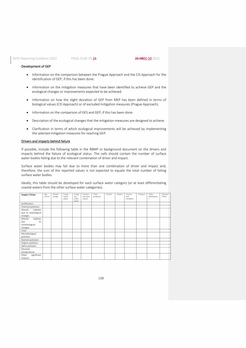
WFD Reporting Guidance 2022 FINAL Draft V5.21 25-0801-10-2021
139
Development of GEP
Information on the comparison between the Prague Approach and the CIS Approach for the identification of GEP, if this has been done.
Information on the mitigation measures that have been identified to achieve GEP and the ecological changes or improvements expected to be achieved.
Information on how the slight deviation of GEP from MEP has been defined in terms of biological values (CIS Approach) or of excluded mitigation measures (Prague Approach).
Information on the comparison of GES and GEP, if this has been done.
Description of the ecological changes that the mitigation measures are designed to achieve.
Clarification in terms of which ecological improvements will be achieved by implementing the selected mitigation measures for reaching GEP.
Drivers and impacts behind failure
If possible, include the following table in the RBMP or background document on the drivers and impacts behind the failure of ecological status. The cells should contain the number of surface water bodies failing due to the relevant combination of driver and impact.
Surface water bodies may fail due to more than one combination of driver and impact and, therefore, the sum of the reported values is not expected to equate the total number of failing surface water bodies.
Ideally, this table should be developed for each surface water category (or at least differentiating coastal waters from the other surface water categories).
Impact / Driver Agri-culture
Climate change
Energy hydro-power
Energy non-hydro-power
Fisheries and aqua-culture
Flood protection
Forestry Industry Tourism and recreation
Transport Urban development
Unknown/ Other
Acidification
Chemical pollution
Altered habitats due to hydrological changes
Altered habitats due to morphological changes
Litter
Microbiological pollution
Nutrient pollution
Organic pollution
Saline pollution
Elevated temperatures
Other significant impacts
WFD Reporting Guidance 2022 FINAL Draft V5.21 25-0801-10-2021
140
There will be cases in which information available is not sufficient to produce this kind of table. This may particularly be the case for certain pressures which are more difficult to quantify, and/or in complex RBDs subject to many pressures, where it is difficult to disaggregate the pressure-failure relationships.
It is expected that Member States report this information to the best extent possible where it is available or can be derived with a reasonable effort. Lack of reporting of this information does not necessarily imply a failure to comply with the WFD obligations.
References:
For further information, refer to the following CIS Guidance Documents:
CIS Guidance Document No. 2: Identification of Water Bodies74
CIS Guidance Document No. 4: Identification and Designation of Heavily Modified and Artificial Water Bodies75
CIS Guidance Document No. 5: Transitional and Coastal Waters – Typology, Reference Conditions and Classification Systems76
CIS Guidance Document No. 10: Rivers and Lakes - Typology, Reference Conditions and Classification Systems.77
CIS Guidance Document No. 13: Overall Approach to the Classification of Ecological Status and Ecological Potential78
EQS for River Basin Specific Pollutants
If EQSs were established for substances which are not monitored, an explanation should be included in the RBMP or background documents, including the same information required in the class SWRBSP above.
7.4. Methodologies for classification of chemical status
Introduction
The legislation covering the assessment of chemical status is presented in detail in the introduction to Section 2.5.
Please note that in this guidance the term ‘Priority Substances’ is used to include not only Priority Substances but also the “certain other pollutants” included in Annex I of Directive 2008/105/EC as amended by Annex II of Directive 2013/39/EU.
74 https://circabc.europa.eu/sd/a/655e3e31-3b5d-4053-be19-15bd22b15ba9/Guidance%20No%202%20-
%20Identification%20of%20water%20bodies.pdf 75 https://circabc.europa.eu/sd/a/f9b057f4-4a91-46a3-b69a-e23b4cada8ef/Guidance%20No%204%20-
%20heavily%20modified%20water%20bodies%20-%20HMWB%20(WG%202.2).pdf 76 https://circabc.europa.eu/sd/a/85912f96-4dca-432e-84d6-a4dded785da5/Guidance%20No%205%20-
%20characterisation%20of%20coastal%20waters%20-%20COAST%20(WG%202.4).pdf 77 https://circabc.europa.eu/sd/a/dce34c8d-6e3d-469a-a6f3-b733b829b691/Guidance%20No%2010%20-
%20references%20conditions%20inland%20waters%20-%20REFCOND%20(WG%202.3).pdf 78 https://circabc.europa.eu/sd/a/06480e87-27a6-41e6-b165-0581c2b046ad/Guidance%20No%2013%20-
%20Classification%20of%20Ecological%20Status%20(WG%20A).pdf
WFD Reporting Guidance 2022 FINAL Draft V5.21 25-0801-10-2021
141
Annex V of the WFD specifies how Member States are to monitor and present status classification. The European Commission needs to ensure that good chemical status has been defined according to the provisions of the Directive, and in a consistent and comparable way throughout the EU. The normative provisions of Annex V provide a starting point. However, interpretation and application of these provisions may differ, which may lead to a wide range of variation among Member States. It is, therefore, important to be able to compare the criteria and thresholds that Member States have applied.
The RBMPs should include information at RBD level on trend monitoring, according to Article 3(3) of Directive 2008/105/EC79 as amended by Directive 2013/39/EU80, and on the designation of mixing zones, according to Article 4. Where a Member State has designated mixing zones, the RBMPs must include a description of:
The approaches and methodologies applied to define such zones.
The measures taken with a view to reducing the extent of the mixing zones in the future.
How will the European Commission and the EEA use the information reported?
Information reported by Member States will be used by the European Commission to establish whether Member States have properly implemented the requirements of the WFD and EQSD in relation to the application of EQSs for Priority Substances, trend monitoring and mixing zones. Statistical tables of the main methodological methods used will be produced.
Statistics and information will be provided to the European Parliament at EU level. Information will be provided to the public through WISE.
Contents of the reporting
7.4.3.1. Information and data to be reported using the schemas
The following class is used to provide information on the standards used for the assessment of chemical status for all substances. This part of the schema will make reference to the values in Directive 2013/39/EU. Report the whole class once for each combination of RBSP, matrix, standard and category.
Schema: SWMET (continued)
Class SWPrioritySubstance
Properties: maxOccurs = unbounded minOccurs = 1
Schema element: psCode
Field type / facets: PS_Enum (see Annex 8d)
Properties: maxOccurs =1 minOccurs = 1
Guidance on completion of schema element: Required. Select a Priority Substance from the
79 http://eur-lex.europa.eu/LexUriServ/LexUriServ.do?uri=OJ:L:2008:348:0084:0097:en:PDF 80 https://eur-lex.europa.eu/LexUriServ/LexUriServ.do?uri=OJ:L:2013:226:0001:0017:EN:PDF

WFD Reporting Guidance 2022 FINAL Draft V5.21 25-0801-10-2021
142
enumeration list. If there is more than one standard per substance (e.g. because there are different standards for different categories or matrices), the same substance can be reported more than once. Each Priority Substance should be reported at least once. Please note, however, that you should report here ‘Total Aldrin + dieldrin + endrin + isodrin’ and not the individual substances separately, as this is the way in which the EQSs are defined in Directive 2013/39/EU. For the same reason, for PAHs, you should report the individual substances and not ‘Total PAHs…’.
Quality checks: Within-schema check: There has to be at least 1 entry per substance in PS_Enum, except for aldrin, dieldrin, endrin, isodrin and Total PAHs, which should not be reported here, since the reporting should be done for Total aldrin+dieldrin+endrin+isodrin and for individual PAHs.
Schema element: psStatusAssessment
Field type / facets: YesNoCode_Enum: Yes, No
Properties: maxOccurs =1 minOccurs = 1
Guidance on completion of schema element: Required. Indicate whether this Priority Substance has been used in the assessment of chemical status.
Schema element: psMatrix
Field type / facets: Matrix_Enum:
Water
Biota
Biota - fish
Biota – other than fish
Sediment
Sediment - settled sediment
Sediment - suspended sediment
Properties: maxOccurs =1 minOccurs = 0
Guidance on completion of schema element: Required. Select from the enumeration list the matrix in which the standard for this Priority Substance is applied for the purpose of assessment of chemical status. If the matrix is biota, you can report generically as ‘biota’ or more specifically fish or other biota. Similarly, if the matrix is sediment, you can report generically or specifically for settled or suspended sediment.
Quality checks: Conditional check: It must be reported if and only if psStatusAssessment = ‘Yes’
Schema element: psStandardsUsed
Field type / facets: YesNoNotApplicable_Union_Enum: Yes, No, Not applicable
Properties: maxOccurs =1 minOccurs = 1
Guidance on completion of schema element: Required. For the combination of Priority Substance and matrix being reported, indicate whether the only standards used are all the relevant ones from Directive 2013/39/EU.
Report ‘Yes’ if all standards in Directive 2013/39/EU were used, and only those.
Report ‘No’ if alternative or additional standards (e.g. for particular water categories) were used
WFD Reporting Guidance 2022 FINAL Draft V5.21 25-0801-10-2021
143
for that substance and matrix.
Report ‘Not applicable’ only if the priority substance has not been used in the assessment of chemical status.
If alternative and/or additional standards are used, report all the standards used for this Priority Substance using the schema elements below, repeating this whole class for each standard.
Quality checks: Within-schema check: ‘Not applicable’ is a valid option only if psStatusAssessment is ‘No’.
Schema element: psCategoryRW
Field type / facets: YesNoCode_Enum: Yes, No
Properties: maxOccurs =1 minOccurs = 0
Guidance on completion of schema element: Conditional. If an alternative and/or additional standard is used, is the standard being reported used for the assessment of chemical status in rivers?
Quality checks: Conditional check: report if and only if psStandardsUsed is 'No'.
Schema element: psCategoryLW
Field type / facets: YesNoCode_Enum: Yes, No
Properties: maxOccurs =1 minOccurs = 0
Guidance on completion of schema element: Conditional. If an alternative and/or additional standard is used, is the standard being reported used for the assessment of chemical status in lakes?
Quality checks: Conditional check: report if and only if psStandardsUsed is 'No'.
Schema element: psCategoryTW
Field type / facets: YesNoCode_Enum: Yes, No
Properties: maxOccurs =1 minOccurs = 0
Guidance on completion of schema element: Conditional. If an alternative and/or additional standard is used, is the standard being reported used for the assessment of chemical status in transitional waters?
Quality checks: Conditional check: report if and only if psStandardsUsed is 'No'.
Schema element: psCategoryCW
Field type / facets: YesNoCode_Enum: Yes, No
Properties: maxOccurs =1 minOccurs = 0
Guidance on completion of schema element: Conditional. If an alternative and/or additional standard is used, is the standard being reported used for the assessment of chemical status in coastal waters?
Quality checks: Conditional check: report if and only if psStandardsUsed is 'No'.
Schema element: psCategoryTeW
Field type / facets: YesNoCode_Enum: Yes, No

WFD Reporting Guidance 2022 FINAL Draft V5.21 25-0801-10-2021
144
Properties: maxOccurs =1 minOccurs = 0
Guidance on completion of schema element: Conditional. If an alternative and/or additional standard is used, is the standard being reported used for the assessment of chemical status in territorial waters?
Quality checks: Conditional check: report if and only if psStandardsUsed is 'No'.
Schema element: psStandardType
Field type / facets: EQStandardType_Enum:
AA EQS
MAC EQS
Biota EQS
Properties: maxOccurs =1 minOccurs = 0
Guidance on completion of schema element: Conditional. If an alternative and/or additional standard is used, select the type of standard being reported.
‘AA EQS’ = Annual Average Concentration.
‘MAC EQS’ = Maximum Allowable Concentration.
‘Biota EQS’ = Concentration in biota.
Quality check: Conditional check: report if and only if psStandardsUsed is 'No'.
Within-schema check: ‘Biota EQS’ has to be reported if and only if psMatrix is ‘Biota’, ‘Biota –fish’ or ‘Biota – other than fish’.
Schema element: psValue
Field type / facets: String100Type
Properties: maxOccurs =1 minOccurs = 0
Guidance on completion of schema element: Conditional. If an alternative and/or additional standard is used, report the value or range of the standard applied.
Quality checks: Conditional check: report if and only if psStandardsUsed is 'No'.
Element check: Reporting must be either one single value or a range, written as ‘xxx – yyy’.
Schema element: psUnit
Field type / facets: UnitOfMeasure_Enum (see Annex 8f)
Properties: maxOccurs =1 minOccurs = 0
Guidance on completion of schema element: Conditional. If an alternative and/or additional standard is used, report the unit in which the Priority Substance standard is expressed. Please report ‘{other}’ only if the unit used is not included in the enumeration list.
Quality checks: Conditional check: report if and only if psStandardsUsed is 'No'.
Schema element: psScale
Field type / facets: GeographicalScale_Enum (see Annex 8l)
Properties: maxOccurs =1 minOccurs = 0

WFD Reporting Guidance 2022 FINAL Draft V5.21 25-0801-10-2021
145
Guidance on completion of schema element: Conditional. If an alternative and/or additional standard is used, report the geographical scale at which the standard is applied.
Quality checks: Conditional check: report if and only if psStandardsUsed is 'No'.
Schema element: psAnalyticalMethod
Field type / facets: YesNoCode_Enum: Yes, No
Properties: maxOccurs =1 minOccurs = 1
Guidance on completion of schema element: Required. Indicate whether the analytical method used meets the minimum performance criteria laid down in Article 4.1 of the QA/QC Directive (2009/90/EC)81 for the strictest standard applied.
Schema element: psAnalyticalMethodBAT
Field type / facets: YesNoCode_Enum: Yes, No
Properties: maxOccurs =1 minOccurs = 0
Guidance on completion of schema element: Conditional. If the analytical method does not meet the minimum performance criteria laid down in Article 4(1) of the QA/QC Directive, indicate whether the analytical method complies with the requirements laid down in Article 4(2) of the QA/QC Directive (2009/90/EC) for the strictest standard applied.
Quality checks: Conditional check: Report if and only if psAnalyticalMethod is ‘No’.
The following class is used to report information on the methodology for the classification of chemical status at the level of the RBD.
Schema: SWMET (continued)
Class SWChemicalStatusClassificationRBD
Properties: maxOccurs = 1 minOccurs = 1
Schema element: approachSWBNotMonitoredChemicalReference
Field type / facets: ReferenceType (see Annex 9)
Properties: maxOccurs =unbounded minOccurs = 0
Guidance on completion of schema element: Conditional. If the assessment of chemical status of surface water bodies which have not been monitored is derived or extrapolated from monitoring in other comparable surface water bodies, provide references or hyperlinks to technical documents describing how the assessment of chemical status was carried out. Guidance on what should be included in this document is provided in Section 7.4.3.27.4.3.2.
Quality checks: Conditional check: Report if and only if SWB/SurfaceWaterBody/swChemicalMonitoringResults is ‘Grouping’ or ‘Combination monitoring/grouping’ for at least one surface water body in this RBD.
Schema element: limitOfQuantification
81 http://eur-lex.europa.eu/LexUriServ/LexUriServ.do?uri=OJ:L:2009:201:0036:0038:EN:PDF
WFD Reporting Guidance 2022 FINAL Draft V5.21 25-0801-10-2021
146
Field type / facets: YesNoCode_Enum: Yes, No
Properties: maxOccurs =1 minOccurs = 1
Guidance on completion of schema element: Required. Indicate whether the method used for dealing with measurements lower than the limit of quantification is as specified in Article 5 of the QA/QC Directive (2009/90/EC).
Schema element: backgroundConcentrations
Field type / facets: YesNoCode_Enum: Yes, No
Properties: maxOccurs =1 minOccurs = 1
Guidance on completion of schema element: Required. Indicate whether natural background concentrations for metals and their compounds are taken into consideration where such concentrations prevent compliance with the relevant EQS.
Schema element: backgroundConcentrationsReference
Field type / facets: ReferenceType (see Annex 9)
Properties: maxOccurs =unbounded minOccurs = 0
Guidance on completion of schema element: Conditional. If natural background concentrations for metals and their compounds are taken into consideration where such concentrations prevent compliance with the relevant EQS, provide references or hyperlinks to technical documents where further specific information can be found, particularly the list of metals concerned. Guidance on what should be included in this document is provided in Section 7.4.3.27.4.3.2.
Quality checks: Conditional check: Report if and only if backgroundConcentrations is ‘Yes’.
Schema element: bioavailability
Field type / facets: YesNoCode_Enum: Yes, No
Properties: maxOccurs =1 minOccurs = 1
Guidance on completion of schema element: Required. Indicate whether hardness, pH, dissolved organic carbon or other water quality parameters that affect the bioavailability of metals are taken into consideration when assessing monitoring results against relevant EQSs.
Schema element: bioavailabilityReference
Field type / facets: ReferenceType (see Annex 9)
Properties: maxOccurs =unbounded minOccurs = 0
Guidance on completion of schema element: Conditional. If water quality parameters affecting the bioavailability of metals are taken into consideration when assessing monitoring results against relevant EQSs, provide references or hyperlinks to technical documents where further specific information can be found, particularly the list of metals concerned. Guidance on what should be included in this document is provided in Section 7.4.3.27.4.3.2.
Quality checks: Conditional check: Report if and only if bioavailability is ‘Yes’.
Schema element: longTermTrendAnalysis
Field type / facets: YesNoCode_Enum: Yes, No
Properties: maxOccurs =1 minOccurs = 1

WFD Reporting Guidance 2022 FINAL Draft V5.21 25-0801-10-2021
147
Guidance on completion of schema element: Required. Indicate whether arrangements are in place for the long-term trend analysis of concentrations of those Priority Substances listed in Part A of Annex I of Directive 2008/105/EC82 that tend to accumulate in sediment and/or biota (Article 3(3) EQSD).
Schema element: longTermTrendAnalysisReference
Field type / facets: ReferenceType (see Annex 9)
Properties: maxOccurs =unbounded minOccurs = 0
Guidance on completion of schema element: Conditional. If arrangements are in place for the long-term trend analysis of concentrations of those Priority Substances listed in Part A of Annex I of Directive 2008/105/EC that tend to accumulate in sediment and/or biota, provide references or hyperlinks to technical documents where further specific information can be found, particularly the list of Priority Substances concerned. Guidance on what should be included in this document is provided in Section 7.4.3.27.4.3.2.
Quality checks: Conditional check: Report if and only if longTermTrendAnalysis is ‘Yes’.
Schema element: mixingZoneMethodology
Field type / facets: YesNoCode_Enum: Yes, No
Properties: maxOccurs =1 minOccurs = 0
Guidance on completion of schema element: Conditional. If mixing zones were designated in this RBD, indicate whether the methodology for their designation follows the tiered approach as laid down in the ’Technical Background Document on Identification of Mixing Zones’83.
Quality checks: Conditional check: Report if and only if SWB/SurfaceWaterBody/swMixingZones is ‘Yes’ for at least one surface water body in this RBD.
Schema element: alternativeMixingZoneMethodologyReference
Field type / facets: ReferenceType (see Annex 9)
Properties: maxOccurs =unbounded minOccurs = 0
Guidance on completion of schema element: Conditional. If the methodology for the designation of Mixing Zones in this RBD does not follow the tiered approach as laid down in the ’Technical Background Document on Identification of Mixing Zones’, provide references or hyperlinks to technical documents describing the alternative methodology applied. Guidance on what should be included in this document is provided in Section 7.4.3.27.4.3.2.
Quality checks: Conditional check: Report if and only if mixingZoneMethodology is ‘No’.
Schema element: mixingZoneMeasures
Field type / facets: MixingZoneMeasures_Enum:
Measures according to Article 11(3)(k) of the WFD
82 http://eur-lex.europa.eu/LexUriServ/LexUriServ.do?uri=OJ:L:2008:348:0084:0097:en:PDF 83 https://circabc.europa.eu/sd/d/78ce94bb-6f1c-4379-87ac-
88a18967c4c3/Technical%20Background%20Document%20on%20the%20Identification%20of%20Mixing%20Zones.doc

WFD Reporting Guidance 2022 FINAL Draft V5.21 25-0801-10-2021
148
Review of permits referred to in the IPPC Directive84
Prior regulations referred to in Article 11(3)(g) of the WFD
Other
Properties: maxOccurs =1 minOccurs = 0
Guidance on completion of schema element: Conditional. If mixing zones were designated in this RBD, indicate the measures taken with a view to reducing the extent of Mixing Zones in the future.
Quality checks: Conditional check: Report if and only if SWB/SurfaceWaterBody/swMixingZones is ‘Yes’ for at least one surface water body in this RBD.
Schema element: mixingZoneMeasuresReductionReference
Field type / facets: ReferenceType (see Annex 9)
Properties: maxOccurs =unbounded minOccurs = 0
Guidance on completion of schema element: Conditional. If mixing zones were designated in this RBD, provide references or hyperlinks to documents describing the measures taken with a view to reducing the extent of Mixing Zones in the future. Guidance on what should be included in this document is provided in Section 7.4.3.27.4.3.2.
Quality checks: Conditional check: Report if and only if SWB/SurfaceWaterBody/swMixingZones is ‘Yes’ for at least one surface water body in this RBD.
Schema element: chemicalStatusReference
Field type / facets: ReferenceType (see Annex 9)
Properties: axOccurs =unbounded minOccurs = 1
Guidance on completion of schema element: Required. Provide references or hyperlinks to documents describing the methodology for the assessment of chemical status. Guidance on what should be included in this document is provided in Section 7.4.3.27.4.3.2.
7.4.3.2. Guidance on contents of RBMPs/Background Documents
The following provides guidance on aspects that the European Commission expects to find in the relevant chapters on methodologies in the RBMPs or in background documents. This guidance is not intended to be exhaustive in terms of what the Member States have to include in their RBMPs or background documents, but rather to provide certain concrete elements of information that the European Commission expects to find.
Information on the significant changes that have taken placesince the previous RBMP, if any, on the methodology or the basis of information used for the assessment of chemical status.
84 Directive 2008/1/EC of the European Parliament and of the Council of 15 January 2008 concerning integrated
pollution prevention and control, OJ L 24, 29.1.2008

WFD Reporting Guidance 2022 FINAL Draft V5.21 25-0801-10-2021
149
Information on the approach taken in the assessment of chemical status in surface water bodies for which there is no monitoring. If status has been derived or extrapolated from monitoring data in comparable surface water bodies, explain how this has been done and in how many instances.
Detailed information on how measurements lower than the limit of quantification are dealt with, if different from the method specified in Article 5 of the QA/QC Directive (2009/90/EC).
Detailed information on the methodology used for dealing with natural background concentrations.
Detailed information on the methodology used for dealing with pH, Dissolvable Organic Carbon or other water quality parameters that affect the bioavailability of metals. If the existing draft CIS Guidance on metal EQSs is endorsed by Water Directors in time to be used for the 3rd RBMPs, or if that guidance was used even if still in draft form, please provide information on how it was used.
Detailed information on the methodology used for long term trend analysis of Priority Substances.
Detailed methodology for the designation of Mixing Zones.
Detailed information on the measures taken with a view to reducing the extent of Mixing Zones.
7.5. Overall management objectives (nutrients, river continuity)
Introduction
Some Member States have established management objectives to address a specific issue. Reporting on these objectives can provide useful quantitative information about objectives at RBD level.
Contents of the reporting
7.5.2.1. Information and data to be reported using the schemas
Schema: SWMET (continued)
Class SWManagementObjectives
Properties: maxOccurs = 1 minOccurs = 1
Schema element: managementObjectivesNutrients
Field type / facets: YesNoCode_Enum: Yes, No
Properties: maxOccurs =1 minOccurs = 1
Guidance on completion of schema element: Required. Indicate whether overall management objectives have been set for nutrient pollution.

WFD Reporting Guidance 2022 FINAL Draft V5.21 25-0801-10-2021
150
Schema element: managementObjectivesNutrientsQuantitativeN
Field type / facets: YesNoCode_Enum: Yes, No
Properties: maxOccurs =1 minOccurs = 0
Guidance on completion of schema element: Conditional. Indicate whether quantitative objectives have been set in terms of nitrogen load reduction.
Quality checks: Conditional check: Report if and only if managementObjectivesNutrients is ‘Yes’.
Schema element: managementObjectivesNutrientsQuantitativeP
Field type / facets: YesNoCode_Enum: Yes, No
Properties: maxOccurs =1 minOccurs = 0
Guidance on completion of schema element: Conditional. Indicate whether quantitative objectives have been set in terms of phosphorus load reduction.
Quality checks: Conditional check: Report if and only if managementObjectivesNutrients is ‘Yes’.
Schema element: managementObjectivesContinuity
Field type / facets: YesNoCode_Enum: Yes, No
Properties: maxOccurs =1 minOccurs = 1
Guidance on completion of schema element: Required. Indicate whether overall management objectives have been set for river continuity.
Schema element: managementObjectivesContinuityQuantitative
Field type / facets: YesNoCode_Enum: Yes, No
Properties: maxOccurs =1 minOccurs = 0
Guidance on completion of schema element: Conditional. Indicate whether quantitative objectives have been set in terms of river continuity (e.g. km of rivers connected, number of obstacles to be made passable, etc).
Quality checks: Conditional check: Report if and only if managementObjectivesContinuity is ‘Yes’.
Schema element: managementObjectivesReference
Field type / facets: ReferenceType (see Annex 9)
Properties: maxOccurs =unbounded minOccurs = 0
Guidance on completion of schema element: Conditional. Provide references to the documents and sections where further information on the management objectives can be found. Guidance on what should be included in this document is provided in Section 7.5.2.27.5.2.2.
Quality checks: Conditional check: Report if and only if managementObjectivesNutrients is ‘Yes’ or managementObjectivesContinuity is ‘Yes’ or both are ‘Yes’.
Schema element: waterResourcePlans
Field type / facets: YesNoRBMPCode_Union_Enum: Yes, No, RBMP
Properties: maxOccurs =1 minOccurs = 1
Guidance on completion of schema element: Required. Indicate whether separate Water Resource

WFD Reporting Guidance 2022 FINAL Draft V5.21 25-0801-10-2021
151
Plans have been developed in relation to abstractions and e-flows or whether this topic is included in the RBMP.
Schema element: waterResourcePlansReference
Field type / facets: ReferenceType (see Annex 9)
Properties: maxOccurs =unbounded minOccurs = 0
Guidance on completion of schema element: Conditional. If there are Water Resource Plans, please upload or provide the hyperlinks to the relevant documents.
Quality checks: Conditional check: Report if and only if waterResourcePlans is ‘Yes’.
7.5.2.2. Guidance on contents of RBMPs/background Documents
The following provides guidance on aspects that the European Commission expects to find in the relevant chapters in the RBMPs or in background documents if management objectives have been set. This guidance is not intended to be exhaustive in terms of what the Member States have to include in their RBMPs or background documents, but rather to provide certain concrete elements of information that the European Commission expects to find.
For nutrient load, the current nutrient load, the target nutrient load for each RBD/Sub-unit and the load reduction required for the impacted groups of surface water bodies.
For continuity, the current status of continuity for each Sub-unit (yes, no, partial). This information should be provided for 2015, 2021, 2027 and the target date by when the Sub-unit will be connected to the river network.
Member States may also include in the documents information on other management objectives that have been set for other parameters.
7.6. Definition of significant pressures and impacts
Introduction
A key part of the characterisation of surface water bodies is the assessment of the risk that a surface water body may fail the objectives of the WFD unless appropriate measures are taken. The results of the risk assessment inform the monitoring of surface water bodies and the subsequent classification of status. It is crucial that methodologies used in risk assessment are fit for purpose in the sense of being able to identify and quantify all significant pressures within the RBD and their potential impact on status of surface water bodies (CIS Guidance Document No. 385). If not, (expensive) measures may be incorrectly targeted and objectives may (unexpectedly) not be met.
85 https://circabc.europa.eu/sd/a/7e01a7e0-9ccb-4f3d-8cec-aeef1335c2f7/Guidance%20No%203%20-
%20pressures%20and%20impacts%20-%20IMPRESS%20(WG%202.1).pdf

WFD Reporting Guidance 2022 FINAL Draft V5.21 25-0801-10-2021
152
How will the European Commission and the EEA use the information reported?
The information will be used by the European Commission to ensure that the analysis of pressures and measures has been carried out in accordance with the provisions of the WFD, and in a consistent and comparable way throughout the EU.
In addition to the compliance assessment, a series of outputs will be produced identifying the most common tools used for the assessment of pressures and impacts, in order to promote best practice.
Statistics and information will be provided to the European Parliament at EU level. Information will be provided to the public through WISE.
Contents of the reporting
7.6.3.1. Information and data to be reported using the schemas
Schema: SWMET (continued)
Class SWPressures
Properties: maxOccurs = 1 minOccurs = 1
Schema element: swPressuresNotAssessed
Field type / facets: SignificantPressureType_Enum (see Annex 1a)
Properties: maxOccurs =unbounded minOccurs = 1
Guidance on completion of schema element: Required. Select from the enumeration list the pressure types that have not been assessed (i.e. pressure types that have not been considered because they are not relevant for surface waters, they were not deemed to be important in the RBD, no information was available, or any other reason). If all pressures have been assessed report ‘Not applicable’. The option ‘No significant pressureNo significant pressuresNo significant pressuress’ is not valid.
Quality checks: Element check: the option ‘No significant pressureNo significant pressures’ is not valid.
Schema element: swSignificantPressurePointSourceTools
Field type / facets: SignificantPressureTools_Enum:
Numerical tools
Expert judgment
Combination of both
Not assessed
Properties: maxOccurs =1 minOccurs = 1
Guidance on completion of schema element: Required. Report the tools that have been used to define significant pressures from point sources. ‘Numerical tools’ includes modelling.
Schema element: swSignificantPressureDiffuseSourceTools
Field type / facets: SignificantPressureTools_Enum:

WFD Reporting Guidance 2022 FINAL Draft V5.21 25-0801-10-2021
153
Numerical tools
Expert judgment
Combination of both
Not assessed
Properties: maxOccurs =1 minOccurs = 1
Guidance on completion of schema element: Required. Report the tools that have been used to define significant pressures from diffuse sources. ‘Numerical tools’ includes modelling.
Schema element: swSignificantPressureWaterAbstractionTools
Field type / facets: SignificantPressureTools_Enum:
Numerical tools
Expert judgment
Combination of both
Not assessed
Properties: maxOccurs =1 minOccurs = 1
Guidance on completion of schema element: Required. Report the tools that have been used to define significant pressures from water abstractions. ‘Numerical tools’ includes modelling.
Schema element: swSignificantPressureWaterFlowTools
Field type / facets: SignificantPressureTools_Enum:
Numerical tools
Expert judgment
Combination of both
Not assessed
Properties: maxOccurs =1 minOccurs = 1
Guidance on completion of schema element: Required. Report the tools that have been used to define significant pressures from water flow regulation and morphological alterations. ‘Numerical tools’ includes modelling.
Schema element: swSignificantPressureOtherSourceTools
Field type / facets: SignificantPressureTools_Enum:
Numerical tools
Expert judgment
Combination of both
Not assessed
Properties: maxOccurs =1 minOccurs = 1
Guidance on completion of schema element: Required. Report the tools that have been used to define significant pressures from other sources. ‘Numerical tools’ includes modelling.

WFD Reporting Guidance 2022 FINAL Draft V5.21 25-0801-10-2021
154
Schema element: swSignificanceDefinition
Field type / facets: YesNoCode_Enum: Yes, No
Properties: maxOccurs =1 minOccurs = 1
Guidance on completion of schema element: Required. Indicate whether significance has been defined in terms of thresholds.
Schema element: swSignificanceLinkFailure
Field type / facets: YesNoCode_Enum: Yes, No
Properties: maxOccurs =1 minOccurs = 1
Guidance on completion of schema element: Required. Indicate whether the definition of significance is linked to the potential failure of objectives.
Schema element: swPressuresReference
Field type / facets: ReferenceType (see Annex 9)
Properties: maxOccurs =unbounded minOccurs = 1
Guidance on completion of schema element: Required. Provide references or hyperlinks to the relevant document and sections where other information relating to pressure types can be found. Guidance on what should be included in this document is provided in Section 7.6.3.27.6.3.2.
7.6.3.2. Guidance on contents of RBMPs/background documents
The following provides guidance on aspects that the European Commission expects to find in the relevant chapters on pressures and impacts in the RBMPs or in background documents. This guidance is not intended to be exhaustive in terms of what the Member States have to include in their RBMPs or background documents, but rather to provide certain concrete elements of information that the European Commission expects to find.
Include an explanation of any major change in the criteria for the identification of pressures since the second RBMP, such as adding new pressures (e.g. invasive alien species) or not reporting pressures (e.g. diffuse pollution by mercury). Also report an explanation of the changes in the methodology or the criteria (e.g. thresholds) used for the assessment of significance as regards pressures and impacts.
Provide details on the approach to the definition of ‘significant pressure’ in particular its relationship with thresholds which may have been set, the relationship with the risk assessment (i.e. the presence of any significant pressures meaning that the surface water body is at risk), and with status (i.e. significant pressures are compatible with good status).
Provide information on the tools used to define significant pressures from:
o Point sources.
o Diffuse sources.
o Abstractions.

WFD Reporting Guidance 2022 FINAL Draft V5.21 25-0801-10-2021
155
o Water flow regulation and morphological alterations.
o Other sources.
Provide the reasons why certain pressures have been excluded from the pressures and impacts analysis (if this was the case).
Provide details on the thresholds used for the determination of significance.
If thresholds have not been used, how has significance been defined?
7.7. Methodologies for exemptions
Introduction
The WFD defines its Environmental Objectives in Article 4 and sets the aim for long-term sustainable water management. Article 4(1) defines the general objective of good status (or potential for AWBs and HMWBs) to be achieved in all surface water bodies by 2015, and introduces the principle of preventing any further deterioration of status.
A number of exemptions to the general objective are possible under certain conditions. Article 4(4) allows for an extension of the deadline beyond 2015, Article 4(5) allows for the achievement of less stringent objectives, Article 4(6) allows a temporary deterioration in the status of water bodies and Article 4(7) sets out conditions in which deterioration of status or failure to achieve certain of the WFD Environmental Objectives may be permitted for new modifications to the physical characteristics of surface water bodies, and deterioration from high to good status may be possible as a result of new sustainable human development activities.
The WFD provides the general framework on exemptions but there are differences in understanding and implementation. From the outset of implementation, it was clear that the use of exemptions needed to be explained further and the rules for application had to be made clearer. These clarifications can be found in the CIS Guidance Document No. 20 on exemptions.86
How will the European Commission and the EEA use the information reported?
The European Commission will use the information provided to determine whether the methodology used to justify exemptions is robust and complies with the requirements of the WFD.
In addition to the compliance assessment, a series of outputs will be produced identifying the most common tools used for the justification of exemptions, in order to promote best practice.
Statistics and information will be provided to the European Parliament at EU level. Information will be provided to the public through WISE.
86 https://circabc.europa.eu/sd/a/2a3ec00a-d0e6-405f-bf66-
60e212555db1/Guidance_documentN%C2%B020_Mars09.pdf

WFD Reporting Guidance 2022 FINAL Draft V5.21 25-0801-10-2021
156
Contents of the reporting
7.7.3.1. Information and data to be reported using the schemas
Schema: SWMET (continued)
Class SWExemptions
Properties: maxOccurs = 1 minOccurs = 1
Schema element: swExemption44Impact
Field type / facets: SignificantImpactType_Enum (see Annex 1b)
Properties: maxOccurs =unbounded minOccurs = 1
Guidance on completion of schema element: Required. Select from the enumeration list the impacts that are causing the application of exemptions under Article 4(4). More than one impact may be selected. If Article 4(4) exemptions have not been applied report ‘NOTA - Not applicable’.
The option ‘NOSI - No significant impact’ is not valid.
Quality checks: Element check: The option ‘NOSI - No significant impact’ is not valid.
Cross-schema check: The option ‘NOTA – Not applicable’ should be reported if and only if ‘Article 4(4)…’ has not been reported for:
- any surface water body under SWB/SWEcologicalExemptionType/swEcologicalExemptionType, SWB/QualityElement/qeEcologicalExemptionType or SWB/SWChemicalExemptionType/swChemicalExemptionType; and
- any protected area under SWB/SWAssociatedProtectedArea/protectedAreaExemption
Schema element: swExemption44Driver
Field type / facets: Driver_Enum (see Annex 1c) or ‘Exemption not applied’
Properties: maxOccurs =unbounded minOccurs = 1
Guidance on completion of schema element: Required. Select from the enumeration list the drivers that are causing the application of exemptions under Article 4(4). More than one driver may be selected. If Article 4(4) exemptions have not been applied report ‘Exemption not applied’.
Quality checks: Within-schema check: ‘Exemption not applied’ should be reported if and only if swExemption44Impact is ‘NOTA – Not applicable’.
Schema element: swExemption45Impact
Field type / facets: SignificantImpactType_Enum (see Annex 1b)
Properties: maxOccurs =unbounded minOccurs = 1
Guidance on completion of schema element: Required. Select from the enumeration list the impacts that are causing the application of exemptions under Article 4(5). More than one impact may be selected. If Article 4(5) exemptions have not been applied report ‘NOTA - Not applicable’.
The option ‘NOSI - No significant impact’ is not valid.
Quality checks: Element check: The option ‘NOSI - No significant impact’ is not valid.
Cross-schema check: The option ‘NOTA – Not applicable’ should be reported if and only if ‘Article

WFD Reporting Guidance 2022 FINAL Draft V5.21 25-0801-10-2021
157
4(5)…’ has not been reported for:
- any surface water body under SWB/SWEcologicalExemptionType/swEcologicalExemptionType, SWB/QualityElement/qeEcologicalExemptionType or SWB/SWChemicalExemptionType/swChemicalExemptionType; and
- any protected area under SWB/SWAssociatedProtectedArea/protectedAreaExemption
Schema element: swExemption45Driver
Field type / facets: Driver_Enum (see Annex 1c) or ‘Exemption not applied’
Properties: maxOccurs =unbounded minOccurs = 1
Guidance on completion of schema element: Required. Select from the enumeration list the drivers that are causing the application of exemptions under Article 4(5). More than one driver may be selected. If Article 4(5) exemptions have not been applied report ‘Exemption not applied’.
Quality checks: Within-schema check: ‘Exemption not applied’ should be reported if and only if swExemption45Impact is ‘NOTA – Not applicable’.
Schema element: swDisproportionateCost
Field type / facets: YesNoCode_Enum: Yes, No
Properties: maxOccurs =1 minOccurs = 1
Guidance on completion of schema element: Required. Indicate if disproportionate costs have been reported as a reason for applying exemptions under Article 4(4) or 4(5) for surface water bodies.
Schema element: swDisproportionateCostScale
Field type / facets: GeographicalScale_Enum (see Annex 8l)
Properties: maxOccurs =unbounded minOccurs = 0
Guidance on completion of schema element: Conditional. Select from the enumeration list the scale(s) at which the calculation of costs was carried out in order to assess disproportionality.
Quality checks: Conditional check: report if and only if swDisproportionateCost is ‘Yes’.
Schema element: swDisproportionateCostAnalysis
Field type / facets: DisproportionateCostAnalysis_Enum:
Cost-benefit analysis
Benefits assessment
Assessment of the consequences of non-action
Distribution of costs
Social and sectoral impacts
Affordability
Cost-effectiveness analysis
Other
Properties: maxOccurs =unbounded minOccurs = 0
Guidance on completion of schema element: Conditional. Select from the enumeration list the

WFD Reporting Guidance 2022 FINAL Draft V5.21 25-0801-10-2021
158
analysis tools that were used in assessing disproportionate costs. More than one analysis tool may be selected.
Quality checks: Conditional check: report if and only if swDisproportionateCost is ‘Yes’
Schema element: swDisproportionateCostAlternativeFinancing
Field type / facets: DisproportionateCostAlternativeFinancing_Enum:
Distribution of costs among polluters and users
Use of public budget (national level)
Use of public budget (regional level)
Use of public budget (local level)
Private investment
EU funds
International funds
Other
Properties: maxOccurs =unbounded minOccurs = 0
Guidance on completion of schema element: Conditional. Select from the enumeration list the alternative financing options that have been considered to overcome the costs being disproportionate. More than one financing option may be selected.
Quality checks: Conditional check: report if and only if swDisproportionateCost is ‘Yes’.
Schema element: swDisproportionateCostOtherEULegislation
Field type / facets: YesNoCode_Enum: Yes, No
Properties: maxOccurs =1 minOccurs = 0
Guidance on completion of schema element: Conditional. Indicate whether the costs of basic measures listed in Article 11(3)(a) of the WFD have been explicitly excluded from the assessment of disproportionate costs.
Quality checks: Conditional check: report if and only if swDisproportionateCost is ‘Yes’
Schema element: swTechnicalInfeasibility
Field type / facets: TechnicalInfeasibility_Enum:
No technical solution is available
It takes longer to fix the problem than there is time available
There is no information on the cause of the problem so a solution cannot be identified
Other
Technical infeasibility has not been used as a reason for exemption
Properties: maxOccurs =unbounded minOccurs = 1
Guidance on completion of schema element: Required. Report how ‘technical infeasibility’ has been interpreted in the context of application of exemptions for surface water bodies. More than one option may be selected.

WFD Reporting Guidance 2022 FINAL Draft V5.21 25-0801-10-2021
159
Quality checks: Within-schema check: the option ‘Technical infeasibility has not been used as a reason for exemption’ is not compatible with any other.
Schema element: swNaturalConditions
Field type / facets: SWNaturalConditions_Enum:
Re-establishment of flora and fauna
Natural hydrogeological conditions
Other
Natural condition has not been used as a reason for exemption for surface water bodies
Properties: maxOccurs =unbounded minOccurs = 1
Guidance on completion of schema element: Required. Select from the enumeration list the elements considered when determining that natural conditions require an exemption under Article 4(4).
Quality checks: Within-schema check: the option ‘Natural condition has not been used as a reason for exemption for surface water bodies’ is not compatible with any other.
Schema element: swExemption46
Field type / facets: Exemption46_Enum:
Accidents
Extreme floods
Prolonged droughts
Article 4(6) has not been applied
Properties: maxOccurs =unbounded minOccurs = 1
Guidance on completion of schema element: Required. Select from the enumeration list the reasons that have led to the application of exemptions under Article 4(6). More than one reason may be selected.
Quality checks: Within-schema check: the option ‘Article 4(6) has not been applied’ is not compatible with any other.
Cross-schema check: The option ‘Article 4(6) has not been applied’ should be reported if and only if ‘Article 4(6)…’ has not been reported for:
- any surface water body under SWB/SWEcologicalExemptionType/swEcologicalExemptionType, SWB/QualityElement/qeEcologicalExemptionType or SWB/SWChemicalExemptionType/swChemicalExemptionType; and
- any protected area under SWB/SWAssociatedProtectedArea/protectedAreaExemption
Schema element: swExemption47
Field type / facets: Exemption47_Enum:
Hydropower plants
Flood protection schemes
Navigation projects

WFD Reporting Guidance 2022 FINAL Draft V5.21 25-0801-10-2021
160
Impoundment for drinking water supply
Mining project
Other
Article 4(7) has not been applied
Properties: maxOccurs =unbounded minOccurs = 1
Guidance on completion of schema element: Required. Select from the enumeration list the modifications that have led to the application of exemptions under Article 4(7). More than one modification may be selected.
Quality checks: Within-schema check: the option ‘Article 4(7) has not been applied’ is not compatible with any other.
Cross-schema check: The option ‘Article 4(7) has not been applied’ should be reported if and only if ‘Article 4(7)…’ has not been reported for:
- any surface water body under SWB/SWEcologicalExemptionType/swEcologicalExemptionType, SWB/QualityElement/qeEcologicalExemptionType or SWB/SWChemicalExemptionType/swChemicalExemptionType; and
- any protected area under SWB/SWAssociatedProtectedArea/protectedAreaExemption
Schema element: swExemptionsTransboundary
Field type / facets: YesNoNotApplicable_Union_Enum: Yes, No, Not applicable
Properties: maxOccurs =1 minOccurs = 1
Guidance on completion of schema element: Required. Indicate whether the application of exemptions for surface waters has been co-ordinated in a transboundary context. Report ‘Not applicable’ if the RBD is not international.
Quality checks: Cross-schema check: Report ‘Not applicable’ if and only if RBDSUCA/RBD/internationalRBD is ‘No’.
Schema element: swExemptionsReference
Field type / facets: ReferenceType (see Annex 9)
Properties: maxOccurs =unbounded minOccurs = 1
Guidance on completion of schema element: Required. Provide references or hyperlinks to the relevant documents and sections where specific information on the application of exemptions for surface water bodies can be found. Guidance on what should be included in this document is provided in Section 7.7.3.27.7.3.2.
Schema element: driversSWExemptionsReference
Field type / facets: ReferenceType (see Annex 9)
Properties: maxOccurs =unbounded minOccurs = 1
Guidance on completion of schema element: Required. Provide references or hyperlinks to the relevant documents and sections where information on the drivers behind exemptions for surface water bodies can be found. Guidance on what should be included in this document is provided in Section 7.7.3.27.7.3.2.

WFD Reporting Guidance 2022 FINAL Draft V5.21 25-0801-10-2021
161
7.7.3.2. Guidance on contents of RBMPs/background documents
The following provides guidance on aspects that the European Commission expects to find in the relevant chapters on exemptions in the RBMPs or in background documents. This guidance is not intended to be exhaustive in terms of what the Member States have to include in their RBMPs or background documents, but rather to provide certain concrete elements of information that the European Commission expects to find.
Description of the analysis tools that were used in assessing disproportionate costs.
Description of the alternative financing options considered to overcome disproportionate costs and reasons for any options not being taken further.
Information on whether the costs of basic measures have been excluded from the assessment of disproportionate costs.
Definition of technical infeasibility.
Description of the elements considered when determining that natural conditions require an exemption under Article 4(4).
If Article 4(6) is applied:
o Description of the instances in which Article 4(6) has been applied, the reasons, the levels of the indicators which make the circumstances exceptional, the surface water bodies affected and the extent of the impacts, the measures taken to restore surface water bodies affected and the effects of such measures.
For each application of Article 4(7), justification and explanation of the reasons for the project and the fulfilment of the conditions under Article 4(7), including:
o Details on how the project has been assessed for deterioration of status or failure to achieve WFD environmental objectives, based on a QE level.
o Explanation on how the assessment of cumulative effects has been considered in the application of Article 4(7).
o Details of the mitigation measures that are in place in relation to the application of Article 4(7).
o Description of the methodology for assessing over-riding public interest in the application of Article 4(7).
o Description of the methodology for assessing the benefits in the application of Article 4(7).
o Details of the better environmental options that have been considered in the application of Article 4(7).
WFD Reporting Guidance 2022 FINAL Draft V5.21 25-0801-10-2021
162
Details of transboundary co-ordination that has taken place in the application of exemptions.
Drivers and impacts behind exemptions
If possible, include the following table in the RBMP or background document on the drivers and impacts behind exemptions from good status. The cells should contain the number of surface water bodies in which an exemption of any kind is applied relevant to each driver and impact.
Surface water bodies may have exemptions due to more than one combination of drivers and impacts and, therefore, the sum of the reported values is not expected to equate the total number of surface water bodies with exemptions.
Ideally, this table should be developed for each surface water category (or at least differentiating coastal waters from the other surface water categories).
Impact / Driver Agri-culture
Climate change
Energy hydro-power
Energy non-hydro-power
Fisheries and aqua-culture
Flood protection
Forestry Industry Tourism and recreation
Transport Urban development
Unknown/ Other
Acidification
Chemical pollution
Altered habitats due to hydrological changes
Altered habitats due to morphological changes
Litter
Microbiological pollution
Nutrient pollution
Organic pollution
Saline pollution
Elevated temperatures
Other significant impacts
There will be cases in which information available is not sufficient to produce this kind of table. This may particularly be the case for certain pressures which are more difficult to quantify, and/or in complex RBDs subject to many pressures, where it is difficult to disaggregate the pressure-exemption relationships.
It is expected that Member States report this information to the best extent possible where it is available or can be derived with a reasonable effort. Lack of reporting of this information does not necessarily imply a failure to comply with the WFD obligations.
8. REPORTING AT RBD LEVEL FOR GROUNDWATER (SCHEMA GWMET)
8.1. Overview of reporting of methodologies for groundwater bodies
Reporting of methodologies for groundwater bodies is done for each RBD. For the purpose of presentation in this guidance, the contents of reporting are structured according to the following sub-chapters:

WFD Reporting Guidance 2022 FINAL Draft V5.21 25-0801-10-2021
163
Methodologies for characterisation
Methodologies for classification of chemical status, for upward trend assessment, for trend reversal, for classification of quantitative status and for transboundary co-ordination
Definition of significant pressures and impacts
Methodologies for exemptions
The following sections describe the contents of reporting.
8.2. Methodologies for characterisation
Introduction
Article 5 of the WFD requires Member States to identify the location and boundaries of groundwater bodies that will be used for assessing progress with, and achievement of, the WFDs Environmental Objectives.
Identifying the size of groundwater bodies was an important parameter that had implications on the design of the monitoring programmes and on the development of appropriate programmes of measures. For groundwater bodies, the WFD requires Member States to further characterise groundwater bodies at risk taking account of the relevant information listed in Annex II 2(2). Full identification should have been completed by 2010 for publication in the first RBMPs and was, in some cases, revised as a result of the review and update (if necessary) of the Article 5 analysis.
Article 5 and Annex VII of the WFD also require Member States to analyse the characteristics of groundwater bodies and to provide a summary report on groundwater body characterisation in the RBMPs.
How will the European Commission and the EEA use the information reported?
The European Commission will use the information provided to check that Member States have established and applied methodologies in accordance with the WFD and GWD, and whether the methodologies are comparable among Member States and RBDs. Statistics and information will be provided to the European Parliament at EU level. Information will be provided to the public through WISE.
Contents of the reporting
8.2.3.1. Information and data to be reported using the schemas
Schema: GWMET
Class GWMethodologies
Properties: maxOccurs = 1 minOccurs = 1
Schema element: gwCharacterisationReference
Field type / facets: ReferenceType (see Annex 9)
Properties: maxOccurs = unbounded minOccurs = 1
Guidance on completion of schema element: Required. There are no standard methodologies for the delineation and characterisation of groundwater bodies, therefore no targeted questions have
WFD Reporting Guidance 2022 FINAL Draft V5.21 25-0801-10-2021
164
been developed. Member States should, however, provide information relating to the initial characterisation and further characterisation of groundwater bodies. See Section 8.2.3.2 for the detailed information that is required.
Provide references or hyperlinks to the relevant documents where specific information can be found.
8.2.3.2. Guidance on contents of RBMPs/background documents
The following provides guidance on aspects that the European Commission expects to find in the relevant chapters on characterisation in the RBMPs or in background documents. This guidance is not intended to be exhaustive in terms of what the Member States have to include in their RBMPs or background documents, but rather to provide certain concrete elements of information that the European Commission expects to find.
In relation to the initial characterisation of groundwater bodies (WFD Annex II(2)(1)) the information provided in the RBMPs and background documents should include:
How the uses of groundwater bodies and the degree to which they are at risk were assessed.
The methodology for grouping groundwater bodies (if applicable).
How significant flow has been identified in order to identify aquifers.
How significant abstractions have been identified in order to identify aquifers.
The specific criteria used for the delineation of groundwater bodies. The criteria may cover the following aspects:
o Significant water flow.
o Flow characteristics of geological strata.
o Flow between strata within an aquifer.
o Geological boundaries.
o Other hydraulic boundaries.
o Differences in status.
o Connection to directly dependent surface water or terrestrial ecosystems.
o Other.
How the methodology for the initial characterisation of groundwater bodies has been refined until the third RBMPs.

WFD Reporting Guidance 2022 FINAL Draft V5.21 25-0801-10-2021
165
In relation to the further characterisation of groundwater bodies at risk (WFD Annex II(2)(2)), information on how the following items have been addressed should be included in the RBMPs and/or background documents:
Geological characteristics of the groundwater bodies including the extent and type of geological units.
Hydrogeological characteristics of the groundwater bodies including hydraulic conductivity, porosity and confinement.
Characteristics of the superficial deposits and soils in the catchment from which the groundwater bodies receive their recharge, including the thickness, porosity, hydraulic conductivity, and absorptive properties of the deposits and soils.
Stratification characteristics of the groundwater within the groundwater bodies.
Associated surface systems, including terrestrial ecosystems and bodies of surface water, with which the groundwater bodies are dynamically linked, including the direction and rates of exchange of water.
The calculation of the long term annual average rate of overall recharge.
The chemical composition of the groundwater.
Any typologies for groundwater characterisation that have been developed.
8.3. Methodologies for classification of chemical status, upward trend assessment, trend reversal, classification of quantitative status, and transboundary co-ordination
Introduction
Annex V of the WFD specifies how Member States are to monitor groundwater, present chemical and quantitative status classification results and identify groundwater bodies with significant and sustained upward trends87 in pollutant concentrations. The detailed provisions and criteria for chemical status and trend assessments are laid down in the GWD88.
In addition to the reporting requirements of the WFD, the GWD introduces several additional reporting requirements to ensure that status and trends relating to groundwater bodies have been defined according to the provisions of the GWD and in a consistent and comparable way across the EU.
The reporting requirements include threshold values, which are groundwater quality standards set by Member States. These have to be reported along with a summary of the methodology used for
87 In this guidance the term 'significant and sustained upward trends' refers to the definition in Article 2(3) of the
GWD. 88 http://eur-lex.europa.eu/legal-content/EN/TXT/PDF/?uri=CELEX:32006L0118&from=EN

WFD Reporting Guidance 2022 FINAL Draft V5.21 25-0801-10-2021
166
identifying the pollutants (or indicators of pollution) and deriving threshold value(s). The criteria for establishing threshold values are included in Article 3 and Annexes I and II of the GWD (reporting obligations are specified in GWD Article 3(5) and Annex II - Part C). This establishment of threshold values is linked to the pressures and impacts analysis required by Article 5 of the WFD, and to the strategies to prevent and control pollution of groundwater in Article 17 of the WFD.
According to Article 3(1)(b) of the GWD, threshold values have to be established for pollutants, groups of pollutants and indicators of pollution – the relevant parameters – which have been identified as contributing to the characterisation of groundwater bodies as being at risk of not meeting the WFD Article 4 objectives, taking into account at least the list of the pollutants in GWD Annex II - Part B.
The GWD requires Member States to report the methodology used to classify chemical status of groundwater bodies. The requirements are laid down in WFD Annex V, and in GWD Article 4 and Annex III (reporting requirements in GWD Article 4(4) and Annex III - point 5).
Furthermore, the GWD requires Member States to report the method used for trend assessment, including the way in which results from monitoring at individual monitoring sites have been used. The starting point for trend reversal and the reasons for selecting it must also be reported. Requirements for the identification of upward trends and the definition of starting points for trend reversal are laid down in GWD Article 5 and Annex IV (reporting requirements in GWD Articles 5(4) and 5(5) and in Annex IV - Part A - point 3).
How will the European Commission and the EEA use the information reported?
Information provided by Member States will be used to ascertain whether they have established and applied methodologies in accordance with the WFD and GWD for: deriving threshold values; assessing status (chemical and quantitative); and identifying environmentally significant pollutant trends (and starting points for trend reversal).
The European Commission will check that the methods applied are comparable among Member States and RBDs. The comparison of assessment criteria and thresholds will make the results of the status assessment more transparent and will allow any differences to be identified. Information on threshold values and the substances for which such values have been established will be summarised and analysed.
Statistics and information will be provided to the European Parliament at EU level. Information will be provided to the public through WISE.
Contents of the reporting
8.3.3.1. Information and data to be reported using the schemas
Schema: GWMET (continued)
Class GWMethodologies (continued)
Properties: maxOccurs = 1 minOccurs = 1
Schema element: diminutionDamage
WFD Reporting Guidance 2022 FINAL Draft V5.21 25-0801-10-2021
167
Field type / facets: YesNoNotApplicable_Union_Enum: Yes, No, Not applicable
Properties: maxOccurs =1 minOccurs = 1
Guidance on completion of schema element: Required. Indicate whether diminution of surface water chemical and ecological quality and damage to groundwater dependent terrestrial ecosystems due to transfer of pollutants from the groundwater body have been considered in the assessment of chemical status.
Report ‘Not applicable’ if there are no groundwater dependent surface water or terrestrial ecosystems.
Quality checks: Cross-schema check: ‘Not applicable’ is a valid choice only if GWB/GroundWaterBody/linkSurfaceWaterBody is ‘No’ for all groundwater bodies and GWB/GroundWaterBody/linkTerrestrialEcosystem is also ‘No’ for all groundwater bodies.
Schema element: methodCriterionExtentExceedance
Field type / facets: MethodCriteriumExtentExeedence_Enum: Method 1, Method 2, Method 3, Other, None, Not relevant
Properties: maxOccurs =1 minOccurs = 1
Guidance on completion of schema element: Required. Report which method or criterion has been applied to estimate the extent of the groundwater body that exceeds groundwater quality standards or threshold values, and what extent of the groundwater body exceeding groundwater quality standard or threshold value is considered acceptable for a groundwater body to be considered in good chemical status:
- Method 1: Proportion (%) of the number of monitoring sites exceeding a groundwater quality standard or threshold value compared to the total number of monitoring sites in the whole groundwater body
- Method 2: Proportion (%) of the total area of the groundwater body represented by monitoring sites exceeding a groundwater quality standard or threshold value compared to the total area of the groundwater body.
- Method 3: Proportion (%) of the total volume of the groundwater body represented by monitoring sites exceeding a groundwater quality standard or threshold value compared to the total volume of the groundwater body.
- Other - None - Not relevant, as no monitoring site exceeds any groundwater quality standard or threshold
value for any pollutant
Schema element: proportionExceedanceAllowed
Field type / facets: NumberDecimal0100Type
Properties: maxOccurs =1 minOccurs = 0
Guidance on completion of schema element: Conditional. If Method 1, Method 2 or Method 3 has been used to estimate the extent of the groundwater body that exceeds groundwater quality standards or threshold values, state the proportion (%) of monitoring sites, area or volume (as appropriate) where exceedance is considered acceptable for a groundwater body to be considered in good chemical status.
Quality checks: Conditional check: Report if and only if methodCriterionExtentExceedance is

WFD Reporting Guidance 2022 FINAL Draft V5.21 25-0801-10-2021
168
‘Method 1’, ‘Method 2’ or ‘Method 3’.
Schema element: impactsGWAbstractionBalance
Field type / facets: YesNoCode_Enum: Yes, No
Properties: maxOccurs = 1 minOccurs = 1
Guidance on completion of schema element: Required. Has whether the available groundwater resource is not exceeded by the long term annual average rate of abstraction been considered when assessing groundwater quantitative status?
For further information regarding abstraction, refer to CIS Guidance Document No. 18 on groundwater status and trend assessment.89
Schema element: impactsGWAbstractionSWObjective
Field type / facets: YesNoCode_Enum: Yes, No
Properties: maxOccurs = 1 minOccurs = 1
Guidance on completion of schema element: Required. Has failure to achieve the WFD Environmental Objectives for associated surface water bodies resulting from anthropogenic water level alteration or change in flow conditions been considered when assessing groundwater quantitative status?
For further informationregarding abstraction, refer to CIS Guidance Document No. 18 on groundwater status and trend assessment.8985
Schema element: impactsGWAbstractionSWDiminutionStatus
Field type / facets: YesNoCode_Enum: Yes, No
Properties: maxOccurs = 1 minOccurs = 1
Guidance on completion of schema element: Required. Has significant diminution in the status of surface waters resulting from anthropogenic water level alteration or change in flow conditions been considered when assessing groundwater quantitative status?
For further information regarding abstraction, refer to CIS Guidance Document No. 18 on groundwater status and trend assessment.8985
Schema element: impactsGWAbstractionDamageGWDE
Field type / facets: YesNoCode_Enum: Yes, No
Properties: maxOccurs = 1 minOccurs = 1
Guidance on completion of schema element: Required. Has significant damage to groundwater-dependent terrestrial ecosystems resulting from an anthropogenic water level alteration been considered when assessing groundwater quantitative status?
For further information regarding abstraction, refer to CIS Guidance Document No. 18 on groundwater status and trend assessment.8985
Schema element: impactsGWAbstractionSalineIntrusion
89 https://circabc.europa.eu/sd/a/ff303ad4-8783-43d3-989a-55b65ca03afc/Guidance_document_N%C2%B018.pdf

WFD Reporting Guidance 2022 FINAL Draft V5.21 25-0801-10-2021
169
Field type / facets: YesNoCode_Enum: Yes, No
Properties: maxOccurs = 1 minOccurs = 1
Guidance on completion of schema element: Required. Have regional saline or other intrusions resulting from anthropogenically induced sustained changes in flow direction been considered when assessing groundwater quantitative status?
For further information regarding abstraction, refer to CIS Guidance Document No. 18 on groundwater status and trend assessment.8985
Schema element: availableGroundwaterResource
Field type / facets: YesNoPartially_Union_Enum: Yes, No, Partially
Properties: maxOccurs =1 minOccurs = 1
Guidance on completion of schema element: Required. Indicate whether the criterion of ‘available groundwater resource’ has been applied in accordance with WFD Article 2(27), which defines ‘available groundwater resource’ as the long-term annual average rate of overall recharge of the body of groundwater less the long-term annual rate of flow required to achieve the ecological quality objectives for associated surface waters, to avoid any significant diminution in the ecological status of such waters and to avoid any significant damage to associated terrestrial ecosystems.
Schema element: needsTerrestrialEcosystems
Field type / facets:YesNoNotApplicable_Union_Enum: Yes, No, Not applicable
Properties: maxOccurs =1 minOccurs = 1
Guidance on completion of schema element: Required. Indicate whether the needs of the terrestrial ecosystems associated to groundwater bodies have been assessed. Report ‘Not applicable’ if there are no terrestrial ecosystems associated to groundwater bodies.
Quality checks: Cross-schema check: ‘Not applicable’ is a valid choice if and only if GWB/GroundWaterBody/linkTerrestrialEcosystem is ‘No’ for all groundwater bodies.
Schema element: balanceRechargeAbstraction
Field type / facets: BalanceRechargeAbstraction_Enum: Method 1, Method 2, Method 3, Not considered
Properties: maxOccurs =1 minOccurs = 1
Guidance on completion of schema element: Required. Report the approach used to assess the balance between recharge and abstraction of groundwater.
- Method 1: A comparison of annual average groundwater abstraction against ‘available groundwater resource’ was done for every groundwater body
- Method 2: A comparison of annual average groundwater abstraction against ‘available groundwater resource’ was done for a subset of all groundwater bodies
- Method 3: Where reliable data on groundwater levels across the groundwater body is available, it can be used to identify the presence of a sustained long-term decline in water levels caused by groundwater abstraction. Where such a decline is present it indicates that the conditions for good status are not being met and the groundwater body is considered in poor status.
- Not considered

WFD Reporting Guidance 2022 FINAL Draft V5.21 25-0801-10-2021
170
For further information regarding abstraction, refer to CIS Guidance Document No. 18 on groundwater status and trend assessment.8985
Schema element: trendAssessmentPerformed
Field type / facets: YesNoCode_Enum: Yes, No
Properties: maxOccurs =1 minOccurs = 1
Guidance on completion of schema element: Required. Indicate whether trend assessment in groundwater pollutants was performed.
Schema element: trendAssessmentMethodology
Field type / facets: YesNoCode_Enum: Yes, No
Properties: maxOccurs =1 minOccurs = 0
Guidance on completion of schema element: Conditional. If trend assessment in groundwater pollutants was performed, indicate whether a methodology for identifying significant and upward trends in any pollutant’s concentration has been applied.
Quality checks: Conditional check: Report if and only if trendAssessmentPerformed is ‘Yes’.
Schema element: timeSeries
Field type / facets: YearRangeType
Properties: maxOccurs =1 minOccurs = 0
Guidance on completion of schema element: Conditional. If trend assessment in groundwater pollutants was performed, report the starting and finishing year for that assessment, in the format YYYY--YYYY.
Quality checks: Conditional check: Report if and only if trendAssessmentPerformed is ‘Yes’.
Schema element: statisticalElements
Field type / facets: StatisticalElements_Enum:
Statistical significance
Confidence intervals
None
Properties: maxOccurs =1 minOccurs = 0
Guidance on completion of schema element: Conditional. If trend assessment in groundwater pollutants was performed, select from the enumeration list which statistical element was used.
Quality checks: Conditional check: Report if and only if trendAssessmentPerformed is ‘Yes’.
Schema element: additionalTrendAssessment
Field type / facets: YesNoCode_Enum: Yes, No
Properties: maxOccurs =1 minOccurs = 1
Guidance on completion of schema element: Required. Indicate whether additional trend assessments were applied in order to assess the impacts of existing plumes of pollution (according to Article 5(5) of the GWD).

WFD Reporting Guidance 2022 FINAL Draft V5.21 25-0801-10-2021
171
Schema element: trendReversalMethodology
Field type / facets: YesNoCode_Enum: Yes, No
Properties: maxOccurs =1 minOccurs = 1
Guidance on completion of schema element: Required. Indicate whether a methodology for assessing trend reversal has been established.
Schema element: thresholdValueElementProtectionEcosystem
Field type / facets: YesNoCode_Enum: Yes, No
Properties: maxOccurs = 1 minOccurs = 1
Guidance on completion of schema element: Required. Has the protection of aquatic ecosystems (surface waters) been considered during the establishment of the groundwater threshold values?
Schema element: thresholdValueElementProtectionGWDE
Field type / facets: YesNoCode_Enum: Yes, No
Properties: maxOccurs = 1 minOccurs = 1
Guidance on completion of schema element: Required. Has the protection of groundwater dependent terrestrial ecosystems (e.g. wetlands) been considered during the establishment of the groundwater threshold values?
Schema element: thresholdValueElementProtectionUses
Field type / facets: YesNoCode_Enum: Yes, No
Properties: maxOccurs = 1 minOccurs = 1
Guidance on completion of schema element: Required. Have the actual and potential legitimate uses and functions of groundwater (e.g. drinking water, irrigation, industrial use) been considered during the establishment of the groundwater threshold values?
Schema element: thresholdValueElementSalineIntrusion
Field type / facets: YesNoCode_Enum: Yes, No
Properties: maxOccurs = 1 minOccurs = 1
Guidance on completion of schema element: Required. Have saline or other intrusions been considered during the establishment of the groundwater threshold values?
Schema element: thresholdValuesBackgroundLevels
Field type / facets: ThresholdValuesBackgroundLevels_Enum:
Background levels have been considered in the establishment of threshold values
Background levels have been considered in the status assessment but not in the establishment of threshold values
Background levels are considered in a different way
Background levels have not been considered
Properties: maxOccurs =1 minOccurs = 1
Guidance on completion of schema element: Required. Report whether background levels of

WFD Reporting Guidance 2022 FINAL Draft V5.21 25-0801-10-2021
172
naturally occurring substances have been considered during the establishment of threshold values.
Schema element: transboundaryGWBPresent
Field type / facets: YesNoCode_Enum: Yes, No
Properties: maxOccurs =1 minOccurs = 1
Guidance on completion of schema element: Required. Indicate whether there are any transboundary groundwater bodies in the RBD.
Quality checks: Cross-schema check: ‘No’ should be reported if and only if GWB/GroundWaterBody/groundwaterBodyTransboundary is ‘No’ for all groundwater bodies.
Schema element: transboundaryThresholdValues
Field type / facets: YesNoCode_Enum: Yes, No
Properties: maxOccurs =1 minOccurs = 0
Guidance on completion of schema element: Conditional. If there are transboundary groundwater bodies, indicate whether the establishment of threshold values has been co-ordinated with the neighbouring countries concerned.
Quality checks: Conditional check: Report if and only if transboundaryGWBPresent is ‘Yes’.
Schema element: gwMethodologiesChemicalClassificationReference
Field type / facets: ReferenceType (see Annex 9)
Properties: maxOccurs =unbounded minOccurs = 1
Guidance on completion of schema element: Required. Provide references or hyperlinks to the documents and sections where relevant information relating to methodologies for the classification of chemical status of groundwater, for upward trend assessment and for trend reversal can be found. Guidance on what should be included in this document is provided in Section 8.3.3.28.3.3.2.
Schema element: gwMethodologiesQuantitativeClassificationReference
Field type / facets: ReferenceType (see Annex 9)
Properties: maxOccurs =unbounded minOccurs = 1
Guidance on completion of schema element: Required. Provide references or hyperlinks to the documents and sections where relevant information relating to methodologies for the classification of quantitative status of groundwater can be found. Guidance on what should be included in this document is provided in Section 8.3.3.28.3.3.2.
Schema element: gwMethodologiesTransboundaryReference
Field type / facets: ReferenceType (see Annex 9)
Properties: maxOccurs =unbounded minOccurs = 0
Guidance on completion of schema element: Conditional. If there are transboundary groundwater bodies, provide references or hyperlinks to the documents and sections where relevant information relating to transboundary co-ordination of threshold value setting can be found. Guidance on what should be included in this document is provided in Section 8.3.3.28.3.3.2.
Quality checks: Conditional check: Report if and only if transboundaryGWBPresent is 'Yes'.

WFD Reporting Guidance 2022 FINAL Draft V5.21 25-0801-10-2021
173
The following class is used to report the pollutants or indicators of pollution for which threshold values have been established.
There are large differences in the ranges of threshold values set by Member States for pollutants posing risk to groundwater bodies. Within the CIS Working Group on groundwater, there are on-going efforts to improve comparability of threshold values, and these efforts have focused on the general quality assessment test for groundwater (which considers risk from pollutants and human uses)90. Some changes in the reporting schemas are therefore being introduced, with respect to the reporting for the 2nd RBMPs, with the aim of collecting more precise information on how threshold values are set, whether criteria values are considered in their establishment and which legitimate uses of groundwater are considered. This information is expected to help in improving threshold value comparability across Member States and responds to specific requirements set in Annex II (part C) of the Groundwater Directive (amendments introduced by Directive 2014/80/EU91).
Report the whole class once for each threshold value that has been established. In particular, if threshold values were based on criteria values for uses other than drinking water, irrigation and industry, report this class for each of the other uses considered. You should report this class at least once for each pollutant or indicator of pollution reported as causing risk in one or more groundwater bodies in the RBD, except for nitrate and pesticides if the values used for them are the quality standards identified in GWD Annex I.
If one or more of the pollutants or indicators of pollution for which threshold values have been established are not included in the enumeration list ChemicalSubstances_Union_Enum, the option ‘EEA_00-00-0 – Other chemical parameter’ should be reported once for each of the pollutants or indicators which are not listed. Particular attention should be paid to ensure that substances which are included in the list are not reported as “other” but are instead correctly selected from the enumeration list.
Schema: GWMET (continued)
Class ThresholdValue
Properties; maxOccurs = unbounded minOccurs = 1
Schema element: pollutantIndicatorCode
Field type / facets: ChemicalSubstances_Union_Enum (see Annex 8e)
Properties: maxOccurs =1 minOccurs = 1
Guidance on completion of schema element: Required. Select from the enumeration list each pollutant or indicator of pollution in turn for which threshold values have been established.
‘EEA_00-00-0 – Other chemical parameter’ must be reported only when the pollutant or indicator of pollution for which a threshold value has been established is not included in the enumeration list ChemicalSubstances_Union_Enum.
Quality checks: Cross-schema check: at least one entry in pollutantIndicatorCode must be reported
90 For more detail, see the technical document on threshold values, https://circabc.europa.eu/ui/group/9ab5926d-
bed4-4322-9aa7-9964bbe8312d/library/eb87e8fb-89e7-4ea0-92e7-6e2ceb6d934a/details 91 Commission Directive 2014/80/EU of 20 June 2014, amending Annex II to Directive 2006/118/EC of the European
Parliament and of the Council on the protection of groundwater against pollution and deterioration, OJ L 182, 21.6.2014

WFD Reporting Guidance 2022 FINAL Draft V5.21 25-0801-10-2021
174
for each pollutant or indicator reported as 'Yes' in one or more instances of GWB/GWPollutant/gwPollutantCausingRisk, except for ‘CAS_14797-55-8 – Nitrate’ and ‘EEA_34-01-5 – Pesticides (active substances in pesticides, including their relevant metabolites, degradation and reaction products) – Total’.
Schema element: pollutantIndicatorCodeOther
Field type / facets: string250Type
Properties: maxOccurs = 1 minOccurs = 0
Guidance on completion of schema element: Conditional. If pollutantIndicatorCode is ‘EEA_00-00-0 Other chemical parameter’ please indicate in this field the CAS number (if relevant) and the name of the pollutant or indicator.
Quality check: Conditional check: report if and only if pollutantIndicatorCode is ‘EEA_00-00-0 Other chemical parameter’.
Schema element: thresholdValueRange
Field type / facets: String25Type
Properties: maxOccurs =1 minOccurs = 1
Guidance on completion of schema element: Required. Report the threshold value or range of threshold values established for the selected pollutant or indicator of pollution.
The threshold values established for nitrates and pesticides need only be reported if they are more stringent than the groundwater quality standards identified in GWD Annex I.
Schema element: thresholdValueUnit
Field type / facets: UnitOfMeasure_Enum (see Annex 8f)
Properties: maxOccurs =1 minOccurs = 1
Guidance on completion of schema element: Required. Report the unit of measurement of the threshold value or range of threshold values.
Schema element: thresholdDerivedFromCV
Field type / facets: YesNoCode_Enum: Yes, No
Properties: maxOccurs =1 minOccurs = 1
Guidance on completion of schema element: Required. Indicate whether the threshold values were derived from criteria values.
Quality checks: Within-schema check: If thresholdDerivedFromCV is ‘Yes’, at least one of the elements cvDrinkingWaterValueRange, cvIrrigationValueRange, cvIndustryValueRange or cvOtherDescription needs to be reported. If thresholdDerivedFromCV is ‘No’, none of the elements cvDrinkingWaterValueRange, cvIrrigationValueRange, cvIndustryValueRange or cvOtherDescription should be reported.
Schema element: cvDrinkingWaterValueRange
Field type / facets: String25Type
Properties: maxOccurs =1 minOccurs = 0
Guidance on completion of schema element: Optional. Report the criteria value or range of criteria

WFD Reporting Guidance 2022 FINAL Draft V5.21 25-0801-10-2021
175
values established for the selected pollutant or indicator of pollution for drinking water.
If your report that the threshold values were derived from criteria values (thresholdDerivedFromCV is ‘Yes’) at least one of the elements cvDrinkingWaterValueRange, cvIrrigationValueRange, cvIndustry or cvOtherDescription needs to be reported, together with cvOtherValueRange and the corresponding element on units of measurement.
Schema element: cvDrinkingWaterValueUnit
Field type / facets: UnitOfMeasure_Enum (see Annex 8f)
Properties: maxOccurs =1 minOccurs = 0
Guidance on completion of schema element: Conditional. If cvDrinkingWaterValueRange is reported, report the unit of measurement of the criteria value or range of criteria values.
Quality checks: Conditional check: Report if and only if cvDrinkingWaterValueRange is reported.
Schema element: cvIrrigationValueRange
Field type / facets: String25Type
Properties: maxOccurs =1 minOccurs = 0
Guidance on completion of schema element: Optional. Report the criteria value or range of criteria values established for the selected pollutant or indicator of pollution for irrigation.
If your report that the threshold values were derived from criteria values (thresholdDerivedFromCV is ‘Yes’) at least one of the elements cvDrinkingWaterValueRange, cvIrrigationValueRange, cvIndustry or cvOtherDescription needs to be reported, together with cvOtherValueRange and the corresponding element on units of measurement.
Schema element: cvIrrigationValueUnit
Field type / facets: UnitOfMeasure_Enum (see Annex 8f)
Properties: maxOccurs =1 minOccurs = 0
Guidance on completion of schema element: Conditional. If cvIrrigationValueRange is reported, report the unit of measurement of the criteria value or range of criteria values.
Quality checks: Conditional check: Report if and only if cvIrrigationValueRange is reported.
Schema element: cvIndustryValueRange
Field type / facets: String25Type
Properties: maxOccurs =1 minOccurs = 0
Guidance on completion of schema element: Optional. Report the criteria value or range of criteria values established for the selected pollutant or indicator of pollution for industry.
If your report that the threshold values were derived from criteria values (thresholdDerivedFromCV is ‘Yes’) at least one of the elements cvDrinkingWaterValueRange, cvIrrigationValueRange, cvIndustry or cvOtherDescription needs to be reported, together with cvOtherValueRange and the corresponding element on units of measurement.
Schema element: cvIndustryValueUnit
Field type / facets: UnitOfMeasure_Enum (see Annex 8f)

WFD Reporting Guidance 2022 FINAL Draft V5.21 25-0801-10-2021
176
Properties: maxOccurs =1 minOccurs = 0
Guidance on completion of schema element: Conditional. If cvIndustryValueRange is reported, report the unit of measurement of the criteria value or range of criteria values.
Quality checks: Conditional check: Report if and only if cvIndustryValueRange is reported.
Schema element: cvOtherDescription
Field type / facets: string100Type
Properties: maxOccurs = 1 minOccurs = 0
Guidance on completion of schema element: Optional. If threshold values were based on criteria values for uses other than drinking water, irrigation and industry, describe shortly the use being reported.
If your report that the threshold values were derived from criteria values (thresholdDerivedFromCV is ‘Yes’) at least one of the elements cvDrinkingWaterValueRange, cvIrrigationValueRange, cvIndustry or cvOtherDescription needs to be reported, together with cvOtherValueRange and the corresponding element on units of measurement.
Schema element: cvOtherValueRange
Field type / facets: String25Type
Properties: maxOccurs =1 minOccurs = 0
Guidance on completion of schema element: Conditional. If cvOtherDescription is reported, report the criteria value or range of criteria values established for the selected pollutant or indicator of pollution for the use concerned.
Quality checks: Conditional check: Report if and only if cvOtherDescription is reported.
Schema element: cvOtherValueUnit
Field type / facets: UnitOfMeasure_Enum (see Annex 8f)
Properties: maxOccurs =1 minOccurs = 0
Guidance on completion of schema element: Conditional. If cvOtherValueRange is reported, report the unit of measurement of the criteria value or range of criteria values.
Quality checks: Conditional check: Report if and only if cvOtherValueRange is reported.
Schema element: thresholdValueScale
Field type / facets: GeographicalScale_Enum (see Annex 8l)
Properties: maxOccurs =1 minOccurs = 1
Guidance on completion of schema element: Required. Report the level at which the threshold value is established.
Schema element: startingPointTrendReversal
Field type / facets: ThresholdType NumberPercentageBaseType
Properties: maxOccurs =1 minOccurs = 1
Guidance on completion of schema element: Required. Report the percentage starting point for trend reversal.
WFD Reporting Guidance 2022 FINAL Draft V5.21 25-0801-10-2021
177
The default value is ‘75’, i.e. 75 % of the threshold value.
If different starting points for trend reversal are applied for the same pollutant or indicator at groundwater body level within the RBD, indicate the value of the starting points applied.
If different starting points for trend reversal are applied for the same pollutant or indicator at
groundwater body level within the RBD, report the range of starting points applied using the format
minimumPercentageValue--maximumPercentageValue (e.g. 70--75).
8.3.3.2. Guidance on contents of RBMPs/background documents
The following provides guidance on aspects that the European Commission expects to find in the relevant chapters on trend reversal and establishment of threshold values in the RBMPs or in background documents. This guidance is not intended to be exhaustive in terms of what the Member States have to include in their RBMPs or background documents, but rather to provide certain concrete elements of information that the European Commission expects to find.
Details on whether diminution of surface water chemical and ecological quality and damage to groundwater-dependent terrestrial ecosystems due to transfer of pollutants from the groundwater body has been considered in the assessment of the chemical status.
The method or criterion applied to estimate the extent of the groundwater body that exceeds groundwater quality standards or threshold values.
The conditions or impacts of groundwater abstractions which have been considered when assessing groundwater quantitative status.
How the criterion of ‘available groundwater resource’ has been applied in accordance with WFD Article 2(27).
How the needs of the terrestrial ecosystems associated to groundwater bodies have been assessed.
The approach used to assess the balance between recharge and abstraction of groundwater.
Details on the time series of the trend assessment in groundwater pollutants.
Details on the statistical element of the trend assessment in groundwater pollutants.
Details on whether additional trend assessments were applied in order to assess the impacts of existing plumes of pollution (according to GWD Article 5(5)).
Starting points for trend reversal which are different from 75 % of the groundwater quality standards or threshold values.
The methodology used in the RBD for assessing trend reversal.
WFD Reporting Guidance 2022 FINAL Draft V5.21 25-0801-10-2021
178
Elements and Environmental Quality Objectives considered in the establishment of groundwater threshold values.
Consideration of background levels in the establishment of threshold values.
Co-ordination of establishment of threshold values for transboundary groundwater bodies.
8.4. Definition of significant pressures and impacts
Introduction
A key part of the characterisation of groundwater bodies is the assessment of the risk that a groundwater body may fail the objectives of the WFD unless appropriate measures are taken. The results of the risk assessment inform the monitoring of groundwater bodies and the subsequent classification of status. It is crucial that methodologies used in risk assessment are fit for purpose in the sense of being able to identify and quantify all significant pressures within the RBD and their potential impact on status of groundwater bodies (CIS Guidance Document 392). If not, (expensive) measures may be incorrectly targeted and objectives may (unexpectedly) not be met.
How will the European Commission and the EEA use the information reported?
The information will be used by the European Commission to ensure that the analysis of pressures and measures has been carried out in accordance with the provisions of the WFD, and in a consistent and comparable way throughout the EU.
In addition to the compliance assessment, a series of outputs will be produced identifying the most common tools used for the assessment of pressures and impacts, in order to promote best practice.
Statistics and information will be provided to the European Parliament at EU level. Information will be provided to the public through WISE.
Contents of the reporting
8.4.3.1. Information and data to be reported using the schemas
Schema: GWMET (continued)
Class GWPressures
Properties: maxOccurs = 1 minOccurs = 1
Schema element: gwPressuresNotAssessed
Field type / facets: SignificantPressureType_Enum (see Annex 1a)
92 https://circabc.europa.eu/sd/a/7e01a7e0-9ccb-4f3d-8cec-aeef1335c2f7/Guidance%20No%203%20-
%20pressures%20and%20impacts%20-%20IMPRESS%20(WG%202.1).pdf
WFD Reporting Guidance 2022 FINAL Draft V5.21 25-0801-10-2021
179
Properties: maxOccurs =unbounded minOccurs = 1
Guidance on completion of schema element: Required. Select from the enumeration list the pressure types that have not been assessed (i.e. pressure types that have not been considered because they are not relevant for groundwater, they were not deemed to be important in the RBD, no information was available, or any other reason). If all pressures have been assessed report ‘Not applicable’. The option ‘No significant pressureNo significant pressures’ is not valid.
Quality checks: Element check: the option ‘No significant pressureNo significant pressures’ is not valid.
Schema element: gwSignificantPressurePointSourceTools
Field type / facets: SignificantPressureTools_Enum:
Numerical tools
Expert judgment
Combination of both
Not assessed
Properties: maxOccurs =1 minOccurs = 1
Guidance on completion of schema element: Required. Report the tools that have been used to define significant pressures from point sources. ‘Numerical tools’ includes modelling.
Schema element: gwSignificantPressureDiffuseSourceTools
Field type / facets: SignificantPressureTools_Enum:
Numerical tools
Expert judgment
Combination of both
Not assessed
Properties: maxOccurs =1 minOccurs = 1
Guidance on completion of schema element: Required. Report the tools that have been used to define significant pressures from diffuse sources. ‘Numerical tools’ includes modelling.
Schema element: gwSignificantPressureWaterAbstractionTools
Field type / facets: SignificantPressureTools_Enum:
Numerical tools
Expert judgment
Combination of both
Not assessed
Properties: maxOccurs =1 minOccurs = 1
Guidance on completion of schema element: Required. Report the tools that have been used to define significant pressures from water abstractions. ‘Numerical tools’ includes modelling.
Schema element: gwSignificantPressureArtificialRecharge

WFD Reporting Guidance 2022 FINAL Draft V5.21 25-0801-10-2021
180
Field type / facets: SignificantPressureTools_Enum:
Numerical tools
Expert judgment
Combination of both
Not assessed
Properties: maxOccurs =1 minOccurs = 1
Guidance on completion of schema element: Required. Report the tools that have been used to define significant pressures from artificial recharge. ‘Numerical tools’ includes modelling.
Schema element: gwSignificantPressureOtherSourceTools
Field type / facets: SignificantPressureTools_Enum
Numerical tools
Expert judgment
Combination of both
Not assessed
Properties: maxOccurs =1 minOccurs = 1
Guidance on completion of schema element: Required. Report the tools that have been used to define significant pressures from other sources. ‘Numerical tools’ includes modelling.
Schema element: gwSignificanceDefinition
Field type / facets: YesNoCode_Enum: Yes, No
Properties: maxOccurs =1 minOccurs = 1
Guidance on completion of schema element: Required. Indicate whether significance has been defined in terms of thresholds (see CIS Guidance no. 18).
Schema element: gwSignificanceLinkFailure
Field type / facets: YesNoCode_Enum: Yes, No
Properties: maxOccurs =1 minOccurs = 1
Guidance on completion of schema element: Required. Indicate whether the definition of significance is linked to the potential failure of good status.
Schema element: gwPressuresReference
Field type / facets: ReferenceType (see Annex 9)
Properties: maxOccurs =unbounded minOccurs = 1
Guidance on completion of schema element: Required. Provide references or hyperlinks to the documents and sections where other information relating to pressure types can be found. Guidance on what should be included in this document is provided in Section 8.4.3.28.4.3.2.

WFD Reporting Guidance 2022 FINAL Draft V5.21 25-0801-10-2021
181
8.4.3.2. Guidance on contents of RBMPs/background documents
The following provides guidance on aspects that the European Commission expects to find in the relevant chapters on pressures and impacts in the RBMPs or in background documents. This guidance is not intended to be exhaustive in terms of what the Member States have to include in their RBMPs or background documents, but rather to provide certain concrete elements of information that the European Commission expects to find.
Describe the tools used to define significant pressures from all sources including an assessment of their accuracy and reliability.
Provide the reasons why certain pressures have been excluded from the pressures and impacts analysis (if this was the case).
Provide details on the definition of significance in terms of thresholds.
Provide details on how significance is linked to the failure of good status.
8.5. Methodologies for exemptions
Introduction
The WFD defines its Environmental Objectives in Article 4 and sets the aim for long-term sustainable water management. Article 4(1) defines the general objective of good status to be achieved in all groundwater bodies by 2015, and introduces the principle of preventing any further deterioration of status.
A number of exemptions to the general objective are possible under certain conditions. Article 4(4) allows for an extension of the deadline beyond 2015, Article 4(5) allows for the achievement of less stringent objectives, Article 4(6) allows a temporary deterioration in the status of water bodies and Article 4(7) sets out conditions in which deterioration of status or failure to achieve certain of the WFD Environmental Objectives may be permitted for new modifications to the physical characteristics of surface water bodies, and deterioration from high to good status may be possible as a result of new sustainable human development activities.
The WFD provides the general framework on exemptions but there are differences in understanding and implementation. From the outset of implementation, it was clear that the use of exemptions needed to be explained further and the rules for application had to be made clearer. These clarifications can be found in the CIS Guidance Document No. 20 on exemptions93.
In addition, Article 6(3) of Directive 2006/118/EC94 on the protection of groundwater against pollution and deterioration allows Member States to exempt inputs of pollutants to groundwaters from the programme of measures under certain specified circumstances.
93 https://circabc.europa.eu/sd/a/2a3ec00a-d0e6-405f-bf66-
60e212555db1/Guidance_documentN%C2%B020_Mars09.pdf 94 http://eur-lex.europa.eu/legal-content/EN/TXT/PDF/?uri=CELEX:32006L0118&from=EN

WFD Reporting Guidance 2022 FINAL Draft V5.21 25-0801-10-2021
182
How will the European Commission and the EEA use the information reported?
The European Commission will use the information provided to determine whether the methodology used to justify exemptions is robust and complies with the requirements of the WFD.
In addition to the compliance assessment, a series of outputs will be produced identifying the most common tools used for the justification of exemptions, in order to promote best practice.
Statistics and information will be provided to the European Parliament at EU level. Information will be provided to the public through WISE.
Contents of the reporting
8.5.3.1. Information and data to be reported using the schemas
Schema: GWMET (continued)
Class GWExemptions
Properties: maxOccurs = 1 minOccurs = 1
Schema element: gwExemption44Impact
Field type / facets: SignificantImpactType_Enum (see Annex 1b)
Properties: maxOccurs =unbounded minOccurs = 1
Guidance on completion of schema element: Required. Select from the enumeration list the impacts that are causing the application of exemptions under Article 4(4). More than one impact may be selected. If Article 4(4) exemptions have not been applied report ‘NOTA - Not applicable.
The option 'NOSI - No significant impact' is not valid.
Cross-schema check: The option ‘NOTA – Not applicable’ should be reported if and only if ‘Article 4(4)…’ has not been reported for:
- any groundwater body under GWB/GroundWaterBody/gwQuantitativeExemptionType or GWB/ChemicalExemptionType/gwChemicalExemptionType; and
- any protected area under GWB/GWAssociatedProtectedArea/protectedAreaExemption
Quality checks: Element check: The option 'NOSI - No significant impact' is not valid.
Schema element: gwExemption44Driver
Field type / facets: Driver_Enum (see Annex 1c) or ‘Exemption not applied’
Properties: maxOccurs =unbounded minOccurs = 1
Guidance on completion of schema element: Required. Select from the enumeration list the drivers that are causing the application of exemptions under Article 4(4). More than one driver may be selected. If Article 4(4) exemption has not been applied report ‘Exemption not applied’.
Quality checks: Within-schema check: ‘Exemption not applied’ should be reported if and only if gwExemption44Impact is ‘NOTA – Not applicable’.
Schema element: gwExemption45Impact
Field type / facets: SignificantImpactType_Enum (see Annex 1b)

WFD Reporting Guidance 2022 FINAL Draft V5.21 25-0801-10-2021
183
Properties: maxOccurs =unbounded minOccurs = 1
Guidance on completion of schema element: Required. Select from the enumeration list the impacts that are causing the application of exemptions under Article 4(5). More than one impact may be selected. If Article 4(5) exemptions have not been applied report ‘NOTA - Not applicable’.
The option 'NOSI - No significant impact' is not valid.
Quality checks: Element check: The option ‘NOSI - No significant impact’ is not valid.
Cross-schema check: The option ‘NOTA – Not applicable’ should be reported if and only if ‘Article 4(5)…’ has not been reported for:
- any groundwater body under GWB/GroundWaterBody/gwQuantitativeExemptionType or GWB/ChemicalExemptionType/gwChemicalExemptionType; and
- any protected area under GWB/GWAssociatedProtectedArea/protectedAreaExemption
Schema element: gwExemption45Driver
Field type / facets: Driver_Enum (see Annex 1c) or ‘Exemption not applied’
Properties: maxOccurs =unbounded minOccurs = 1
Guidance on completion of schema element: Required. Select the drivers from the enumeration list that are causing the application of exemptions under Article 4(5). More than one driver may be selected. If Article 4(5) exemptions have not been applied report ‘Exemption not applied’.
Quality checks: Within-schema check: ‘Exemption not applied’ should be reported if and only if gwExemption45Impact is ‘NOTA – Not applicable’.
Schema element: gwDisproportionateCost
Field type / facets: YesNoCode_Enum: Yes, No
Properties: maxOccurs =1 minOccurs = 1
Guidance on completion of schema element: Required. Indicate if disproportionate costs have been reported as a reason for applying exemptions under Article 4(4) or 4(5) for groundwater bodies.
Schema element: gwDisproportionateCostScale
Field type / facets: GeographicalScale_Enum (see Annex 8l)
Properties: maxOccurs =unbounded minOccurs = 0
Guidance on completion of schema element: Conditional. Select from the enumeration list the scale(s) at which the calculation of costs was carried out in order to assess disproportionality.
Quality checks: Conditional check: report if and only if gwDisproportionateCost is ‘Yes’.
Schema element: gwDisproportionateCostAnalysis
Field type / facets: DisproportionateCostAnalysis_Enum:
Cost-benefit analysis
Benefits assessment
Assessment of the consequences of non-action
Distribution of costs

WFD Reporting Guidance 2022 FINAL Draft V5.21 25-0801-10-2021
184
Social and sectoral impacts
Affordability
Cost-effectiveness analysis
Other
Properties: maxOccurs =unbounded minOccurs = 0
Guidance on completion of schema element: Conditional. Select from the enumeration list the analysis tools that were used in assessing disproportionate costs. More than one analysis tool may be selected.
Quality checks: Conditional check: report if and only if gwDisproportionateCost is ‘Yes’
Schema element: gwDisproportionateCostAlternativeFinancing
Field type / facets: DisproportionateCostAlternativeFinancing_Enum:
Distribution of costs among polluters and users
Use of public budget (national level)
Use of public budget (regional level)
Use of public budget (local level)
Private investment
EU funds
International funds
Other
Properties: maxOccurs =unbounded minOccurs = 0
Guidance on completion of schema element: Conditional. Select from the enumeration list the alternative financing options that have been considered to overcome the costs being disproportionate. More than one financing option may be selected.
Quality checks: Conditional check: report if and only if gwDisproportionateCost is ‘Yes’.
Schema element: gwDisproportionateCostOtherEULegislation
Field type / facets: YesNoCode_Enum: Yes, No
Properties: maxOccurs =1 minOccurs = 0
Guidance on completion of schema element: Conditional. Indicate whether the costs of basic measures listed in Article 11(3)(a) of the WFD have been explicitly excluded from the assessment of disproportionate costs.
Quality checks: Conditional check: report if and only if gwDisproportionateCost is ‘Yes’.
Schema element: gwTechnicalInfeasibility
Field type / facets: TechnicalInfeasibility_Enum:
No technical solution is available
It takes longer to fix the problem than there is time available

WFD Reporting Guidance 2022 FINAL Draft V5.21 25-0801-10-2021
185
There is no information on the cause of the problem so a solution cannot be identified
Other
Technical infeasibility has not been used as a reason for exemption
Properties: maxOccurs =unbounded minOccurs = 1
Guidance on completion of schema element: Required. Report how ‘technical infeasibility’ has been interpreted in the context of application of exemptions for groundwater bodies. More than one option may be selected.
Quality checks: Within-schema check: the option ‘Technical infeasibility has not been used as a reason for exemption’ is not compatible with any other.
Schema element: gwNaturalConditions
Field type / facets: GWNaturalConditions_Enum:
Natural hydrogeological conditions
Other
Natural condition has not been used as a reason for exemption for groundwater bodies
Properties: maxOccurs =unbounded minOccurs = 1
Guidance on completion of schema element: Required. Select from the enumeration list the elements considered when determining that natural conditions require an exemption under Article 4(4).
Quality checks: Within-schema check: the option ‘Natural condition has not been used as a reason for exemption for groundwater bodies’ is not compatible with any other.
Schema element: gwExemption46
Field type / facets: Exemption46_Enum:
Accidents
Extreme floods
Prolonged droughts
Article 4(6) has not been applied
Properties: maxOccurs =unbounded minOccurs = 1
Guidance on completion of schema element: Required. Select from the enumeration list the reasons that have led to the application of exemptions under Article 4(6). More than one reason may be selected.
Quality checks: Within-schema check: the option ‘Article 4(6) has not been applied’ is not compatible with any other.
Cross-schema check: The option ‘Article 4(6) has not been applied’ should be reported if and only if ‘Article 4(6)…’ has not been reported for:
- any groundwater body under GWB/GroundWaterBody/gwQuantitativeExemptionType or GWB/ChemicalExemptionType/gwChemicalExemptionType; and
- any protected area under GWB/GWAssociatedProtectedArea/protectedAreaExemption

WFD Reporting Guidance 2022 FINAL Draft V5.21 25-0801-10-2021
186
Schema element: gwExemption47
Field type / facets: Exemption47_Enum:
Hydropower plants
Flood protection schemes
Navigation projects
Impoundment for drinking water supply
Mining project
Other
Article 4(7) has not been applied
Properties: maxOccurs =unbounded minOccurs = 1
Guidance on completion of schema element: Required. Select from the enumeration list the modifications that have led to the application of exemptions under Article 4(7). More than one modification may be selected.
Quality checks: Within-schema check: the option ‘Article 4(7) has not been applied’ is not compatible with any other.
Cross-schema check: The option ‘Article 4(7) has not been applied’ should be reported if and only if ‘Article 4(7)…’ has not been reported for:
- any groundwater body under GWB/GroundWaterBody/gwQuantitativeExemptionType or GWB/ChemicalExemptionType/gwChemicalExemptionType; and
- any protected area under GWB/GWAssociatedProtectedArea/protectedAreaExemption
Schema element: gwExemptionsTransboundary
Field type / facets: YesNoNotApplicable _Enum: Yes, No, Not applicable
Properties: maxOccurs =1 minOccurs = 1
Guidance on completion of schema element: Required. Indicate whether the application of exemptions for groundwater has been co-ordinated in a transboundary context. Report ‘Not applicable’ if the RBD is not international.
Quality checks: Cross-schema check: Report ‘Not applicable’ if and only if RBDSUCA/RBD/internationalRBD is ‘No’.
Schema element: gwExemptionsReference
Field type / facets: ReferenceType (see Annex 9)
Properties: maxOccurs =unbounded minOccurs = 1
Guidance on completion of schema element: Required. Provide references or hyperlinks to the relevant documents and sections where specific information on the application of exemptions for groundwater bodies can be found. Guidance on what should be included in this document is provided in Section 8.5.3.28.5.3.2.
Schema element: driversGWExemptionsReference
Field type / facets: ReferenceType (see Annex 9)

WFD Reporting Guidance 2022 FINAL Draft V5.21 25-0801-10-2021
187
Properties: maxOccurs =unbounded minOccurs = 1
Guidance on completion of schema element: Required. Provide references or hyperlinks to the relevant documents and sections where information on the drivers behind exemptions for groundwater bodies can be found. Guidance on what should be included in this document is provided in Section 8.5.3.28.5.3.2.
8.5.3.2. Guidance on contents of RBMPs/background documents
The following provides guidance on aspects that the European Commission expects to find in the relevant chapters on exemptions in the RBMPs or in background documents. This guidance is not intended to be exhaustive in terms of what the Member States have to include in their RBMPs or background documents, but rather to provide certain concrete elements of information that the European Commission expects to find.
Description of the analysis tools that were used in assessing disproportionate cost.
Description of the alternative financing options considered to overcome disproportionate costs and reasons for any options not being taken further.
Information on whether the costs of basic measures have been excluded from the assessment of disproportionate costs.
Definition of technical infeasibility.
Description of the elements considered when determining that natural conditions require an exemption under Article 4(4).
If Article 4(6) is applied:
o Description of the instances in which Article 4(6) has been applied, the reasons, the levels of the indicators which make the circumstances exceptional, the groundwater bodies affected and the extent of impacts, the measures taken to restore groundwater bodies affected and the effects of such measures.
For each application of Article 4(7), justification and explanation of the reasons for the project and the fulfilment of the conditions under Article 4(7), including:
o Details on how the project has been assessed for deterioration of status or failure to achieve WFD environmental objectives, based on a QE level.
o Explanation on how the assessment of cumulative effects has been considered in the application of Article 4(7).
o Details of the mitigation measures that are in place in relation to the application of Article 4(7).
o Description of the methodology for assessing over-riding public interest in the application of Article 4(7).

WFD Reporting Guidance 2022 FINAL Draft V5.21 25-0801-10-2021
188
o Description of the methodology for assessing the benefits in the application of Article 4(7).
o Details of the better environmental options that have been considered in the application of Article 4(7).
Description of the methodology used for determining exemptions under Article 6(3) of the Groundwater Directive.
Details of transboundary co-ordination that has taken place in the application of exemptions.
Drivers and impacts behind exemptions
If possible, include the following table in the RBMP or background document on the drivers and impacts behind exemptions from good status. The cells should contain the number of groundwater bodies in which an exemption of any kind is applied relevant to each driver and impact.
Groundwater bodies may have exemptions due to more than one combination of drivers and impacts and, therefore, the sum of the reported values is not expected to equate to the total number of groundwater bodies with exemptions.
Impact / Driver Agri-culture
Climate change
Energy hydro-power
Energy non-hydro-power
Fisheries and aqua-culture
Flood protection
Forestry Industry Tourism and recreation
Transport Urban development
Unknown/ Other
Acidification
Chemical pollution
Damage to groundwater-dependent terrestrial ecosystems for chemical / quantitative reasons
Alterations in flow directions resulting in saltwater intrusion
Lowering water table
Microbiological pollution
Nutrient pollution
Organic pollution
Diminution of quality of associated surface waters for chemical / quantitative reasons
Saline pollution/intrusion
Other significant impacts
There will be cases in which information available is not sufficient to produce this kind of table. This may particularly be the case for certain pressures which are more difficult to quantify, and/or in

WFD Reporting Guidance 2022 FINAL Draft V5.21 25-0801-10-2021
189
complex RBD subject to many pressures, where it is difficult to disaggregate the pressure-exemption relationships.
It is expected that Member States report this information to the best extent possible where it is available or can be derived with a reasonable effort. Lack of reporting of this information does not necessarily imply a failure to comply with the WFD obligations.
9. REPORTING AT RBD/SUB-UNIT LEVEL FOR RBMP (SCHEMA RBMPPOM)
9.1. Overview of reporting of information on the RBMP
Reporting of information on the RBMP and Programme of Measures (PoM) is done for each RBD or Sub-unit. For the purpose of presentation in this guidance, the contents of reporting are structured according to the following sub-chapters:
RBMP dates, table of contents, more detailed programmes, justifications, public participation
Inputs of pollutants to surface waters and groundwater, including inventories of emissions, discharges and losses of EQSD Annex I substances
Water abstractions and exploitation of water resources
The following sections describe the contents of reporting.
9.2. RBMP dates, table of contents, more detailed programmes, justifications, public participation
Introduction
The River Basin Management Plan (RBMP) is the main tool for the water management of all surface and groundwater bodies within an RBD and the contents of the RBMP are outlined in Annex VII of the WFD. With respect to water governance, the RBMP shall contain: a general description of the RBD; a summary of the significant pressures and impacts on surface and groundwater bodies; a summary of the measures intended to mitigate the impacts identified; a register of any more detailed plans proposed for sub-basins, sectors, management issues or water categories; a summary of public consultation; and a list of the Competent Authorities, including their relationship with other authorities within the Member State and a summary of institutional relations established to ensure co-ordination in international RBDs.
The WFD sets Environmental Objectives for Member States to attain in surface and groundwater bodies, the default being ‘good status’ by 2015 (unless an exemption applies or the surface water body meets the conditions to be designated as an Artificial or Heavily Modified Water Body). The RBMP is the key tool by which the process to achieve such legally binding Environmental Objectives can be formally set out as a roadmap to implementation and can be subject to review.
The WFD sets out a stepwise approach for the development of the RBMP, and if one requirement is not complete or incorrectly carried out this may pose obstacles for subsequent steps in the implementation process.
A clear and complete RBMP is also important for accountability, as it is also the main tool for communicating to interested parties, including the general public, how integrated water management is, or will be, carried out. Complete draft RBMPs including, as appropriate, draft

WFD Reporting Guidance 2022 FINAL Draft V5.21 25-0801-10-2021
190
background documents, have to be made available, in a timely manner, through the public consultation process, in order to ensure that interested parties are given sufficient information to enable them to express their views in a meaningful way.
How will the European Commission and the EEA use the information reported?
The European Commission will use the information reported to ensure that Member States have properly implemented the WFD, whether more detailed programmes and management plans are in place, and that information has been provided to the public in accordance with the WFD requirements (see also CIS Guidance Document No. 895).
Furthermore, the European Commission will use the information to develop future water policy instruments.
Statistics and information will be provided to the European Parliament at EU level. Information will be provided to the public through WISE.
Contents of the reporting
9.2.3.1. Information and data to be reported using the schemas
Schema: RBMPPoM
Class RBMP
Properties: maxOccurs = 1 minOccurs =1
Schema element: rbmpName
Field type / facets: String1000Type
Properties: maxOccurs =1 minOccurs = 1
Guidance on completion of schema element: Required. Name of the RBMP as published.
Schema element: rbmpTimetablePublicationDate
Field type / facets: DateType
Properties: maxOccurs =1 minOccurs = 1
Guidance on completion of schema element: Required. Date of publication of the timetable for the production of the RBMP, in the format YYYY-MM-DD.
Schema element: rbmpProgrammePublicationDate
Field type / facets: DateType
Properties: maxOccurs =1 minOccurs = 1
Guidance on completion of schema element: Required. Date of publication of the work programme for the production of the RBMP, in the format YYYY-MM-DD.
95 https://circabc.europa.eu/sd/a/0fc804ff-5fe6-4874-8e0d-de3e47637a63/Guidance%20No%208%20-
%20Public%20participation%20(WG%202.9).pdf

WFD Reporting Guidance 2022 FINAL Draft V5.21 25-0801-10-2021
191
Schema element: rbmpConsultationPublicationDate
Field type / facets: DateType
Properties: maxOccurs =1 minOccurs = 1
Guidance on completion of schema element: Required. Date of publication of the consultation measures for the production of the RBMP, in the format YYYY-MM-DD.
Schema element: rbmpInterimOverviewDate
Field type / facets: DateType
Properties: maxOccurs =1 minOccurs = 1
Guidance on completion of schema element: Required. Date of publication of the interim overview of the Significant Water Management Issues, in the format YYYY-MM-DD.
Schema element: rbmpDraftVersionDate
Field type / facets: DateType
Properties: maxOccurs =1 minOccurs = 1
Guidance on completion of schema element: Required. Date of publication of the draft version of the RBMP for public consultation, in the format YYYY-MM-DD.
Schema element: finalRBMPPublicationDate
Field type / facets: DateType
Properties: maxOccurs =1 minOccurs = 1
Guidance on completion of schema element: Required. Date of publication of the final RBMP, in the format YYYY-MM-DD.
Schema element: subPlans
Field type / facets: YesNoCode_Enum: Yes, No
Properties: maxOccurs =1 minOccurs = 1
Guidance on completion of schema element: Required. Indicate whether there are specific sub-plans as mentioned in Article 13.5 of the WFD.
Schema element: subPlansCoverage
Field type / facets: SubPlansCoverage_Enum:
Agriculture
Chemical industry
Hydropower
Transport
Water Scarcity and droughts
Climate change
Coastal erosion
Rural planning
WFD Reporting Guidance 2022 FINAL Draft V5.21 25-0801-10-2021
192
Urban planning
Nutrient enrichment
Chemical pollution
Other
Properties: maxOccurs =unbounded minOccurs = 0
Guidance on completion of schema element: Conditional. If there are specific sub-plans, select the issues they address from the enumeration list. ‘Other’ must be reported only when the issue covered by a sub-plan is not included in the enumeration list SubPlansCoverage_Enum.
Quality checks: Conditional check: Report if and only if subPlans is ‘Yes’.
Schema element: subPlansCoverageOther
Field type / facets: String1000Type
Properties: maxOccurs =1 minOccurs = 0
Guidance on completion of schema element: Conditional. If ‘Other’ is reported under subPlansCoverage, list the issue(s) addressed.
Quality checks: Conditional check: Report if and only if subPlansCoverage is ‘Other’.
Schema element: subPlansReference
Field type / facets: ReferenceType (see Annex 9)
Properties: maxOccurs =unbounded minOccurs = 0
Guidance on completion of schema element: Conditional. Provide references or hyperlinks to the documents and sections where relevant information relating to the sub-plans can be found. Links to the sub-plans themselves can be provided.
Quality checks: Conditional check: Report if and only if subPlans is 'Yes'.
Schema element: sea
Field type / facets: YesNoCode_Enum: Yes, No
Properties: maxOccurs =1 minOccurs = 1
Guidance on completion of schema element: Required. Indicate whether Strategic Environmental Assessments (SEA) have been undertaken on the RBMP and PoM.
Schema element: seaReference
Field type / facets: ReferenceType (see Annex 9)
Properties: maxOccurs =unbounded minOccurs = 0
Guidance on completion of schema element: Conditional. Provide references or hyperlinks to the SEA documents.
Quality checks: Conditional check: Report if and only if sea is 'Yes'.
Schema element: publicConsultationInformation
Field type / facets: PublicConsultationInformation_Enum:

WFD Reporting Guidance 2022 FINAL Draft V5.21 25-0801-10-2021
193
Media (papers, TV, radio)
Internet
Social networking (Twitter, Facebook, etc)
Printed material
Direct mailing
Invitations to stakeholders
Local Authorities
Meetings
Written consultation
Other
Properties: maxOccurs =unbounded minOccurs = 1
Guidance on completion of schema element: Required. Select from the enumeration list the mechanism(s) used for informing the public and interested parties about the consultations on the draft RBMP. More than one mechanism may be selected. ‘Other’ must be reported only when a mechanism used is not included in the enumeration list PublicConsultationInformation_Enum.
Schema element: publicConsultationInformationOther
Field type / facets: String1000Type
Properties: maxOccurs =1 minOccurs = 0
Guidance on completion of schema element: Conditional. If ‘Other’ is reported under publicConsultationInformation, list the mechanism(s) used.
Quality checks: Conditional check: Report if and only if publicConsultationInformation is ‘Other’.
Schema element: rbmpConsultation
Field type / facets: RBMPConsultation_Enum:
Via internet
Via Twitter
Via Facebook
Via other social networking
Direct invitation
Exhibitions
Other outreach methods (e.g. game shows, board games, web-based material for schools)
Telephone surveys
Direct involvement in drafting RBMP
Other
Properties: maxOccurs =unbounded minOccurs = 1
Guidance on completion of schema element: Required. Select from the enumeration list the tool(s)

WFD Reporting Guidance 2022 FINAL Draft V5.21 25-0801-10-2021
194
used to carry out the public consultation on the draft RBMP. More than one tool may be selected. ‘Other’ must be reported only when a tool used is not included in the enumeration list RBMPConsultation_Enum.
Schema element: rbmpConsultationOther
Field type / facets: String1000Type
Properties: maxOccurs =1 minOccurs = 0
Guidance on completion of schema element: Conditional. If ‘Other’ is reported under rbmpConsultation, list the tool(s) used.
Quality checks: Conditional check: Report if and only if rbmpConsultation is ‘Other’.
Schema element: documentProvision
Field type / facets: DocumentProvision_Enum:
Downloadable
Direct mailing (e-mail)
Direct mailing (post)
Paper copies distributed at exhibitions
Paper copies available in governmental buildings
Paper copies available in municipal buildings (town hall, library, etc)
Digital copies available in governmental buildings
Other
Properties: maxOccurs =unbounded minOccurs = 1
Guidance on completion of schema element: Required. Select from the enumeration list the method(s) used to provide the public and interested parties with the consultation documents (e.g. draft RBMPs and background documents). More than one method may be selected. ‘Other’ must be reported only when a method used is not included in the enumeration list DocumentProvision_Enum.
Schema element: documentProvisionOther
Field type / facets: String1000Type
Properties: maxOccurs =1 minOccurs = 0
Guidance on completion of schema element: Conditional. If ‘Other’ is reported under documentProvision, list the method(s) used.
Quality checks: Conditional check: Report if and only if documentProvision is ‘Other’.
Schema element: documentAvailability
Field type / facets: YesNoCode_Enum: Yes, No
Properties: maxOccurs =1 minOccurs = 1
Guidance on completion of schema element: Required. Indicate whether the consultation documents (e.g. draft RBMPs and background documents) were made available for feedback for 6

WFD Reporting Guidance 2022 FINAL Draft V5.21 25-0801-10-2021
195
months.
Schema element: ongoingStakeholderInvolvement
Field type / facets: OngoingStakeholderInvolvement_Enum:
Regular exhibitions
Establishment of advisory groups
Involvement in drafting
Other outreach activities
Formation of alliances
Other
Properties: maxOccurs =unbounded minOccurs = 1
Guidance on completion of schema element: Required. Select from the enumeration list the tools(s) used to achieve a continued active participation of stakeholders in the implementation of the WFD. More than one tool may be selected. ‘Other outreach activities’ or ‘Other’ must be reported only when a tool used is not included in the enumeration list OngoingStakeholderInvolvement_Enum.
Schema element: ongoingStakeholderInvolvementOtherOutreach
Field type / facets: String1000Type
Properties: maxOccurs =1 minOccurs = 0
Guidance on completion of schema element: Conditional. If ‘Other outreach activities’ is reported under ongoingStakeholderInvolvement, list the outreach activities(s) used.
Quality checks: Conditional check: Report if and only if ongoingStakeholderInvolvement is ‘Other outreach activities’.
Schema element: ongoingStakeholderInvolvementOther
Field type / facets: String1000Type
Properties: maxOccurs =1 minOccurs = 0
Guidance on completion of schema element: Conditional. If ‘Other’ is reported under ongoingStakeholderInvolvement, list the tool(s) used.
Quality checks: Conditional check: Report if and only if ongoingStakeholderInvolvement is ‘Other’.
Schema element: stakeholderGroups
Field type / facets: StakeholderGroups_Enum:
Water supply and sanitation
Agriculture / farmers
Energy / hydropower
Navigation / ports
Fisheries / aquaculture
Industry
WFD Reporting Guidance 2022 FINAL Draft V5.21 25-0801-10-2021
196
NGOs / nature protection
Consumer groups
Local / regional authorities
Other
Properties: maxOccurs =unbounded minOccurs = 1
Guidance on completion of schema: Required. Select from the enumeration list the stakeholder groups that have been actively involved in the development of the RBMPs. More than one stakeholder group may be selected. ‘Other’ must be reported only when a group of stakeholders is not included in the enumeration list StakeholderGroups_Enum.
Schema element: stakeholderGroupsOther
Field type / facets: String1000Type
Properties: maxOccurs =1 minOccurs = 0
Guidance on completion of schema element: Conditional check: If stakeholderGroups is ‘Other’, list the stakeholder groups.
Quality checks: Conditional check: Report if and only if stakeholderGroups is ‘Other’.
Schema element: impactPublicParticipation
Field type / facets: ImpactPublicParticipation_Enum:
Changes to selection of measures
Adjustments to specific measures
Addition of new information
Changes to the methodology used
Commitment to further research
Commitment to action in the next RBMP cycle
Other
Properties: maxOccurs =unbounded minOccurs = 1
Guidance on completion of schema element: Required. Select from the enumeration list the impact(s) of the public participation process on the RBMPs. This refers to the whole RBMP process, not just the 6 month public consultation on the draft plan. More than one impact may be selected. ‘Other’ must be reported only when an impact is not included in the enumeration list ImpactPublicParticipation_Enum.
Schema element: impactPublicParticipationOther
Field type / facets: String1000Type
Properties: maxOccurs =1 minOccurs = 0
Guidance on completion of schema element: Conditional. If ‘Other’ is reported under impactPublicParticipation, list the impact(s).
Quality checks: Conditional check: Report if and only if impactPublicParticipation is ‘Other’.

WFD Reporting Guidance 2022 FINAL Draft V5.21 25-0801-10-2021
197
Schema element: internationalCoOrdination
Field type / facets: InternationalCoOrdination_Enum: Category 1, Category 2, Categoy 3, Category 4
Properties: maxOccurs =1 minOccurs = 0
Guidance: Conditional. If the RBD is international, select from the enumeration list the type of international co-operation or co-ordination mechanism(s) that exist between the relevant Member States.
Coordination categories are defined as developed under the project ‘Comparative study of pressures and measures in the major river basin management plans’96:
Category 1: International agreement, permanent co-operation body and international RBMP in place.
Category 2: International agreement and permanent co-operation body in place, but no international RBMP.
Category 3: International agreement in place, but no permanent co-operation body or international RBMP.
Category 4: No formalised co-operation.
Quality checks: Conditional check: Report if and only if RBDSUCA/RBD/internationalRBD is ‘Yes’.
Schema element: internationalCoOrdinationPublicParticipation
Field type / facets: YesNoCode_Enum: Yes, No
Properties: maxOccurs =1 minOccurs = 0
Guidance on completion of schema element: Conditional. If the RBD is international, indicate whether there has been international co-ordination on public participation and active involvement of interested parties.
Quality checks: Conditional check: Report if and only if RBDSUCA/RBD/internationalRBD is ‘Yes’.
Schema element: publicParticipationReference
Field type / facets: ReferenceType (see Annex 9)
Properties: maxOccurs =unbounded minOccurs = 1
Guidance on completion of schema element: Required. Provide references or hyperlinks to the documents and sections where relevant information relating to public participation and its effectiveness can be found, including information on international coordination if any.
Schema element: consultationResponsesReference
Field type / facets: ReferenceType (see Annex 9)
Properties: maxOccurs =unbounded minOccurs = 1
Guidance on completion of schema element: Required. Provide references or hyperlinks to the documents and sections where relevant information on the RBMP public consultation responses can be found.
96 http://ec.europa.eu/environment/archives/water/implrep2007/background.htm.

WFD Reporting Guidance 2022 FINAL Draft V5.21 25-0801-10-2021
198
Schema element: integrationFloodsDirective
Field type / facets: YesNoCode_Enum: Yes, No
Properties: maxOccurs =1 minOccurs = 1
Guidance on completion of schema element: Required. Indicate whether the RBMP and Flood Risk Management Plans produced under the Floods Directive have been integrated into a single plan.
Schema element: coOrdinationFloodsDirective
Field type / facets: YesNoNotApplicable_Union_Enum: Yes, No, Not applicable
Properties: maxOccurs =1 minOccurs = 1
Guidance on completion of schema element: Required. Indicate whether joint consultation was carried out on the RBMP and Flood Risk Management Plans.
Quality check: Within-schema check: 'Not applicable' should be reported only by Norway and/or Iceland
Schema element: fdCoordinationReference
Field type / facets: ReferenceType (see Annex 9)
Properties: maxOccurs =unbounded minOccurs = 0
Guidance on completion of schema element: Required. Provide references or hyperlinks to the documents and sections where relevant information on the coordination of the RBMP with the Floods Directive implementation can be found.
Quality check: Within-schema check: fdCoordinationReference can only be empty if coordinationFloodsDirective is 'Not Applicable'
Schema element: coOrdinationMSFD
Field type / facets: YesNoNotApplicable_Union_Enum: Yes, No, Not applicable
Properties: maxOccurs =1 minOccurs = 1
Guidance: Required. Indicate whether joint consultation was carried out on the RBMPs and Marine Strategy.
Quality check: Within-schema check: 'Not applicable' should be reported only by oversea territories, Norway and/or Iceland
Schema element: msfdCoordinationReference
Field type / facets: ReferenceType (see Annex 9)
Properties: maxOccurs =unbounded minOccurs = 0
Guidance on completion of schema element: Required. Provide references or hyperlinks to the documents and sections where relevant information on the coordination of the RBMP with the Marine Strategy Framework Directive implementation can be found.
Quality check: Within-schema check: msfdCoordinationReference can only be empty if coordinationMSFD is 'Not Applicable'

WFD Reporting Guidance 2022 FINAL Draft V5.21 25-0801-10-2021
199
9.3. Inputs of pollutants to surface waters and groundwater, including inventories of emissions, discharges and losses of substances listed in Annex I of Directive 2008/108/EC as amended by Annex II of Directive 2013/39/EU
Introduction
Article 5 of the Directive 2008/105/EC97 as amended by Directive 2013/39/EU98 requires Member States to establish, on the basis of the information collected in accordance with Articles 5 and 8 of the WFD and other available data such as that collected under Regulation (EC) No 166/200699, an inventory of emissions, discharges and losses of all Priority Substances and the eight other pollutants listed in Part A of Annex I for each RBD, or part thereof, lying within their territory. The CIS Guidance Document No. 28100 addresses the preparation of the inventories at national RBD scale.
Article 5 of the WFD requires Member States to identify the significant anthropogenic pressures in the RBD that are likely to cause individual surface and groundwater bodies to be in less than good status (or to be at risk of deterioration). This is commonly referred to as a ‘pressures and impacts analysis’. According to Annex II, part 1.4 of the WFD, Member States are required to estimate and identify significant point and diffuse source pollution as part of the identification of pressures.
Article 5(5) of the Directive 2008/105/EC101 as amended by Directive 2013/39/EU102 requires the European Commission to verify, by 2018, that emissions, discharges and losses, as reflected in the inventory mentioned above, are making progress towards the reduction or cessation objectives required by the WFD (i.e. that there is a downward trend).
Article 5 of the WFD requires that Member States carry out a similar analysis of pressures for other substances and parameters, i.e. nutrients, deoxygenating substances (COD, BOD), saline discharges, and RBSPs that are discharged in significant quantities to surface and groundwater bodies in each RBD.
Figure 2 on page 16 of the CIS Guidance Document No 28 on inventories103, which is reproduced here (Figure 3Figure 3), illustrates the main routes of pollutant transport into surface waters. It indicates source and pathway apportionment for inputs to surface waters, including via upstream compartments. The annotations P1-P13 in the figure allow each of the source and pathway categories to be referred to when pollution by a chemical substance has been quantified.
The combined expression ‘emissions, discharges and losses’, used in the Directive, refers to the Esbjerg Declaration of the North Sea Convention combining all categories of inputs of chemical
97 http://eur-lex.europa.eu/LexUriServ/LexUriServ.do?uri=OJ:L:2008:348:0084:0097:en:PDF 98 Directive 2013/39/EU of the European Parliament and of the Council of 12 August 2013 amending Directives
2000/60/EC and 2008/105/EC as regards priority substances in the field of water policy 99 http://eur-lex.europa.eu/LexUriServ/LexUriServ.do?uri=OJ:L:2006:033:0001:0017:EN:PDF 100 https://circabc.europa.eu/sd/a/6a3fb5a0-4dec-4fde-a69d-5ac93dfbbadd/Guidance%20document%20n28.pdf 101 http://eur-lex.europa.eu/LexUriServ/LexUriServ.do?uri=OJ:L:2008:348:0084:0097:en:PDF 102 Directive 2013/39/EU of the European Parliament and of the Council of 12 August 2013 amending Directives
2000/60/EC and 2008/105/EC as regards priority substances in the field of water policy 103 https://circabc.europa.eu/sd/a/6a3fb5a0-4dec-4fde-a69d-5ac93dfbbadd/Guidance%20document%20n28.pdf

WFD Reporting Guidance 2022 FINAL Draft V5.21 25-0801-10-2021
200
substances to surface water, designated as ‘inputs’104. Therefore, ’losses’ does not refer to any retention or degradation within soil, groundwater or surface water.
Figure 3Figure 3 identifies four tiers or approaches to establishing inventories, i.e. point source information, riverine load, pathway-oriented and source-oriented. A number of case studies are included in the guidance. The point source information and riverine load approaches are based on monitoring data. Point source information may be limited because permits do not always require monitoring of the concentrations of Priority Substances, and quantification is only required for E-PRTR facilities. If point source information is limited, the use of carefully justified emission factors, together with information on the volume discharged, may provide a more complete picture at the regional scale required for the inventory.
The riverine load approach is limited by the analytical resolution, and in the case of heavy metals also by the fact that only the dissolved fraction (not the solid phase fraction) may have been quantified and by the presence of natural background metal concentrations, which can constitute a significant part of the total load. Quantification of the natural background load is therefore necessary. The riverine load approach is considered capable of yielding a rough estimation of total diffuse inputs from a catchment if the point source inputs are known and the factors mentioned above are properly taken into account. The guidance recommends cross-checking the outputs of the different approaches using the riverine load as validation information for the more complex methods.
The pathway-oriented approach (RPA) involves extensive modelling of transfer processes towards surface waters, and the source-oriented approach takes an even more complex look at the whole system, using, for example, Substance Flow Analysis (SFA). The different approaches provide different results in terms of process information and spatial resolution. So, in general, the RPA provides a better regionalisation of the inputs whereas the SFA provides a more comprehensive view of the actual releases into the environment but is more limited with respect to spatial resolution. The guidance acknowledges the value of source apportionment for identifying control measures.
104 Input = Movement of a substance into the aquatic environment, i.e. sum of emissions, discharges and losses
(inputs) to surface and groundwaters, from land and sea-based sources and from point and diffuse sources, including atmospheric deposition.

WFD Reporting Guidance 2022 FINAL Draft V5.21 25-0801-10-2021
201
P1: Atmospheric Deposition directly to Surface Waters
P2: Erosion P3: Surface Runoff from Unsealed Areas
P4 Interflow, Tile Drainage and Groundwater105
P5: Direct Discharges and Drifting P6: Surface Runoff from Sealed Areas
P7: Storm Water Outlets, Combined Sewer Overflows and Unconnected Sewers
P8: Urban Waste Water Treated P9: Individual - Treated and Untreated- Household Discharges
P10 Industrial Waste Water treated P11: Direct Discharges from Mining Areas106 P12: Direct Discharges from Navigation107 P13 Natural Background
Figure 3 - Figure 2 from CIS Guidance no. 28: General working scheme of the inventory
Guidance Document no. 28 suggests a two-step approach in compiling the inventory. In the first step, substances which are not relevant in the RBD should be identified on the basis of the WFD Article 5 analysis. For those substances, only a basic estimation of significant inputs should be reported, whereas for the remaining substances a more in-depth analysis should be performed, as a minimum based on the riverine load approach and point source inputs.
109 pathway comprises also emissions from contaminated land 106 A portion of the total emissions from abandoned and historic mining sites is discharged to groundwater. Active
mines are covered under "Industry". 107 Inland navigation also comprises waterway construction materials.
RLout
RLin)
WFD Reporting Guidance 2022 FINAL Draft V5.21 25-0801-10-2021
202
It is expected that the more in-depth assessment produces a quantification of total point source inputs and total diffuse source inputs. However, due to data gaps and analytical uncertainty, this may not be possible in all cases. For the evaluation of data reliability, information on the methods used is necessary.
More detailed reporting of information on source (or pathway) apportionment would add substantially to the value of the exercise, and is provided for in the schema elements on an optional basis. Optional reporting of total point source inputs, total diffuse source inputs, and individual sources of RBSPs or other pollutants is also provided for.
Since 2009, the EEA has been collecting, on an annual basis, data on pollutant loads through the State of the Environment (SoE) reporting108 in the framework of EIONET. The source categories for apportioning inputs are similar, in some respects, to the inputs P1-P13 identified in Figure 5, and in that respect they provide an adequate indication of the apportionment.
Other Member States may have used the WFD list of pressure types (Annex 1a to this document), which may also provide an adequate indication.
It is possible to roughly correlate the SoE source categories and WFD pressure types with the pathways identified in the inventory guidance. An indication of how the various categorisations can be correlated is provided in Annex 7. Depending upon the data provided by Member States, i.e. on the categorisation used, the European Commission may use these correlations to analyse and compare the source apportionment in different Member States. Discussion and further follow-up work in the EIONET framework could lead to greater harmonisation of the categorisation.
How will the European Commission and the EEA use the information reported?
As required by the WFD, the inventories will be used by the European Commission to check for compliance with the Environmental Objectives of the WFD (Article 4) on the reduction of emissions, discharges and losses (inputs) of Priority Substances and of the eight other pollutants included in Annex II of Directive 2013/39/EU, and on the cessation or phase-out of inputs of Priority Hazardous Substances.
The inventories will be an important element of the European Commission’s review, according to Article 7(1) of Directive 2008/105/EC as amended by Directive 2013/39/EU, on the possible need to amend existing acts or introduce additional specific EU-wide measures such as emission controls. It will also be essential information for the Commission’s report required by Article 7(2).
The information provided by Member States should throw light on the relevance of pollutants, including Priority Substances, at the spatial scale of the RBD or the national part of an international RBD, and on the loads reaching the aquatic environment, thus supporting Member States in subsequent river basin management and WFD implementation. However, it is recognised that differences in methodologies used will mean that comparison of data from different Member States will be subject to caveats, and work will be needed to improve comparability. Furthermore, since the basis for the emission inventory in each Member State may evolve with time, a proper comparison to determine a trend might require recalculation of the data for an earlier reference
108 http://rod.eionet.europa.eu/obligations/632

WFD Reporting Guidance 2022 FINAL Draft V5.21 25-0801-10-2021
203
year or period, which may not always be possible. For the public, the information should provide greater transparency regarding the possible origin of existing problems and the need for measures to address those problems.
It should be possible, on the basis of the reported data, to illustrate trends in inputs for substances other than the ones in Annex II of Directive 2013/39/EU, as has been done already for nitrogen and phosphorus, and to relate reductions to measures.
Information on source/pathway apportionment will be used to provide European overviews of the contribution made by different sources and pathways to the loads of pollutants.
Statistics and information will be provided, when meaningful, to the European Parliament at EU level. Information will be provided to the public through WISE.
9.3.2.1. Products from reporting
The following list identifies some of the products which will be produced by the European Commission or the EEA from the data and information reported by Member States.
The extent to which products relating to substances other than the ones in Annex II of Directive 2013/39/EU can be developed will depend upon the extent of reporting.
The products will focus on total inputs to surface waters and groundwater, but some could distinguish between surface waters and groundwater if sufficient information is reported. Similarly, products presenting inputs from individual sources might be produced if sufficient source or pathway apportionment data are reported.
Nb
Name of product Type of product
Scale of information*
Detailed information displayed
Source of detailed information and aggregation rule
1 Total (significant) point source inputs of EQSD Annex I substances
Chart, table or map
EU/MS/RBD Inputs from point source categories by substance.
Information reported at RBD or Sub-unit level.
2 Total (significant) diffuse source inputs of EQSD Annex I substances
Chart, table or map
EU/MS/RBD Inputs from diffuse source categories by substance.
Information reported at RBD or Sub-unit level.
3 Trends in total inputs of EQSD Annex I substances
Chart or table
EU/MS/RBD Trend in total point and diffuse source inputs (including by self-assessment if provided), by substance.
Information reported at RBD or Sub-unit level.
4 Total (significant) point source inputs of other substance s/ parameters
Chart, table or map
EU/MS/RBD Inputs from point source categories, by substance.
Information reported at RBD or Sub-unit level.
5 Total (significant) diffuse source inputs of other substances / parameters
Chart, table or map
EU/MS/RBD Inputs from diffuse source categories, by substance.
Information reported at RBD or Sub-unit level.
6 Trends in total Chart EU/MS/RBD Trend in total point and Information reported at RBD or Sub-

WFD Reporting Guidance 2022 FINAL Draft V5.21 25-0801-10-2021
204
inputs of other substances / parameters
or table diffuse source inputs (including by self-assessment if provided), by substance.
unit level.
Contents of the reporting
The schema elements address the minimum requirements on reporting total point and total diffuse source inputs of the substances listed in Annex II of Directive 2013/39/EU. Similar reporting for other substances/parameters is optional.
The reporting of a self-assessed trend (taking into account differences in the coverage of actual inputs between the available time points), is optional.
Schema elements on methodology and on data quality are included to enable an adequate interpretation of the data.
More detailed reporting of information on source or pathway apportionment (categorisation) for all substances is also optional. Member States may select the system they have used to categorise inputs. If Member States are reporting under the SoE process, they may specify that a particular year of data from that process is to be taken into account for source apportionment.
Depending upon the level of detail reported, and the approach used to establish the inventory, it may be possible to report inputs to surface water specifically via groundwater.
9.3.3.1. Information and data to be reported using the schemas
Information regarding the inventory should be reported at Sub-unit level or, if Sub-units were not defined, at RBD level.
Schema: RBMPPoM (continued)
Class InputInventory
Properties: maxOccurs = unbounded minOccurs = 1
Schema element: euSubUnitCode
Field type / facets: FeatureUniqueEUCodeType
Properties: maxOccurs =1 minOccurs = 1
Guidance on completion of schema element: Required. If the RBD has been divided into Sub-units, report the unique EU code of each Sub-unit. If the RBD has not been divided into Sub-units, report the respective sub-unit code used in the spatial data.
Quality checks: Within-schema check: euSubUnitCode must be unique.
Cross-schema check:
The euSubUnitCode must be identical to the thematicIdIdentifier of one the subunits reported for the RBD in the spatial data.
All the sub-units of the RBD must be reported.
WFD Reporting Guidance 2022 FINAL Draft V5.21 25-0801-10-2021
205
Schema element: inputInventoryReference
Field type / facets: ReferenceType (see Annex 9)
Properties: maxOccurs =unbounded minOccurs = 1
Guidance on completion of schema element: Required. Provide references or hyperlinks to the documents and sections where any other relevant information relating to the estimation of the inputs of pollutants can be found.
The following class (child of InputInventory) is used to report information for each pollutant. The reporting is required for each of the substances in Annex II of Directive 2013/39/EU and is optional for other substances for which an inventory can be provided.
Schema RBMPPoM (continued)
Class InputPollutant
Properties: maxOccurs = unbounded minOccurs = 1
Schema element: chemicalSubstance
Field type / facets: ChemicalSubstances_Union_Enum (see Annex 8e)
Properties: maxOccurs =1 minOccurs = 1
Guidance on completion of schema element: Required. Reporting is required for each substance in Annex II of Directive 2013/39/EU
Quality check: Within-schema check:
All substances listed in Annex II of Directive 2013/39/EU (i.e. Priority Substances) have to be reported.
Total cyclodiene pesticides must be reported through EEA_32-02-0 - Total cyclodiene pesticides.
Total PAHs must be reported through EEA_33-56-7 - Total PAHs.
Schema element: reportedUnderSoEEmissions
Field type / facets: YesNoCode_Enum: Yes, No
Properties: maxOccurs =1 minOccurs = 1
Guidance on completion of schema element: Required. Indicate if emissions for this substance were reported as part of the State of Environment reporting.
Schema element: step1RelevantAtRBDScale
Field type / facets: Yes, No, Unknown
Properties: maxOccurs =1 minOccurs = 1
Guidance on completion of schema element: Required
Indicate whether the substance has been identified as being relevant at RBD level (i.e. passed the relevance test in Step 1, according to the relevance criteria described on pages 9-10 of the CIS-Guidance No 28).
Report ‘Yes’ if you proceeded to Step 2 of the two-step approach.

WFD Reporting Guidance 2022 FINAL Draft V5.21 25-0801-10-2021
206
If you report ‘No’, it is possible to report on an optional point source assessment. In this case, any knowledge of quantifiable inputs of priority hazardous substances should be reported.
Quality checks: Conditional checks: The option ‘Unknown’ is valid if and only if the chemicalSubstance is a Priority Substance (i.e. if reporting is mandatory)
Cross-check - If at least one waterbody is failing to achieve good chemical status due to a Priority Substance then step1RelevantAtRBDScale must be ‘Yes’. (The inverse is not true.)
Schema element step2EmissionsInventory
Field type / facets: Yes, No, Not Applicable
Properties: maxOccurs =1 minOccurs = 1
Guidance on completion of schema element: Required. If an inventory of emissions, discharges and losses has been completed for this substance, indicate which approach in CIS Guidance No 28 has been followed.
Step 1 requires an assessment of the current relevance of the substance at RBD level. Step 2 requires a more detailed analysis for the substances that pass the relevance test in Step 1 (i.e. the ones that are relevant at RBD level).
For the substances that are of minor relevance at the RBD scale (i.e. do not meet Step 1 criteria), Member States should try to provide a basic estimation of emissions, discharges and losses from point and diffuse sources. This is particularly important for Priority Hazardous Substances.
Report ‘Yes’ if an inventory has been completed (note: this option can also be used for substances where step1RelevantAtRBDScale = ‘No’.
Report ‘No’, if an inventory has not yet been completed, although the substance was determined to be relevant according to the step 1 criteria.
Report ‘Not applicable’, if a step 2 inventory was not completed because the substance was determined NOT to be relevant according to the step 1 criteria.
Quality checks:
The option ‘No’ is valid if and only if step1RelevantAtRBDScale = ‘Yes’.
The option ‘Not applicable’ is valid if and only if step1RelevantAtRBDScale = ‘No’ (The inverse is not true.
Schema element: inventoryMethodology
Field type / facets: InventoryMethodology_Enum:
Approach 1 (point source information)
Approach 2 (riverine load)
Approach 3 (pathway-oriented)
Approach 4 (source-oriented, e.g. SFA)
Approach 1 + 2
WFD Reporting Guidance 2022 FINAL Draft V5.21 25-0801-10-2021
207
Approach 1 + 2 + 3
Approach 1 + 2 + 4
Approach 1-4
Other
Not applicable
Properties: maxOccurs =1 minOccurs = 1
Guidance on completion of schema element: Required.
If an inventory of emissions, discharges and losses has been completed for this substance, indicates which approach was used to determine the values reported. Further descriptions of the approaches 1, 2, 3 and 4 are available in CIS Guidance Document no. 28.
Report ‘Other’ only if the approach that was used does not fit within one of the approaches listed in the enumeration list. In this cases, describe the methodology used (refer to inputMethodReference).
The approach followed may be different for different substances
Quality check: The option ‘Not applicable’ is NOT valid if step2EmissionsInventory is ‘Yes’.
Schema element: inputMethodReference
Field type / facets: ReferenceType (see Annex 9)
Properties: maxOccurs =unbounded minOccurs = 0
Guidance on completion of schema element: Conditional. If inventoryMethodology is ‘Other’, provide references or hyperlinks to the documents and sections where the methodology used to determine the values reported is described.
Reporting of this element is optional in other cases, although it is desirable if the approaches in the CIS Guidance Document no. 28 have been elaborated or described in an accessible version of the national inventory, in specific documents as part of RBMP reporting, in international seas convention guidance documents or similar.
Quality check: Conditional check: report if inventoryMethodology is ‘Other’.
The following class (child of InputPollutant) is optional and can be used to report trend information for each substance.
Schema RBMPPoM (continued)
Class InputTrend
Properties: maxOccurs = unbounded minOccurs = 0
Guidance on completion of schema class: Optional.
This class can be reported for any substances where an inventory was made inventoryMethodology != ‘Not applicable’
Schema element: inputTrend

WFD Reporting Guidance 2022 FINAL Draft V5.21 25-0801-10-2021
208
Field type / facets: NumberDecimalType
Properties: maxOccurs =1 minOccurs = 1
Guidance on completion of schema element: Report the trend of the substance’s concentration since the previous RBMP (positive or negative). This information will override the trend that can be calculated from the reported values, allowing Member States to take into account possible changes in methodology.
The trend should be expressed in % per year, on average, over the period reported in inputTrendPeriod.
Schema element: inputTrendPeriod
Field type / facets: YearRangeType
Properties: maxOccurs =1 minOccurs = 1
Guidance on completion of schema element: Required. If inputTrend is reported, report the first and last years used for trend assessment.
Quality checks: Conditional check: report if and only if inputTrend is reported.
The following class (child of InputPollutant) must used to report information for each substance for which an inventory was made.
Schema RBMPPoM (continued)
Class InputTotal
Properties: maxOccurs = unbounded minOccurs = 0
Guidance on completion of schema class: Conditional.
Quality checks:
The total value of inputs (= emissions, discharges and losses) must be reported if an inventory was made. for all substances where inventoryMethodology != ‘Not applicable’
Schema element: inputYearPeriod
Field type / facets: InputYearPeriodType
Properties: maxOccurs =1 minOccurs = 1
Guidance on completion of schema element: Required. It is possible to report a single year or a period (e.g. 2018--2020).
Quality checks:
For each substance, the combinations of inputTotalType and inputYearPeriod must be unique.
For each substance and inputTotalType, different inputYearPeriod must not overlap.
Schema element: inputTotalType
Field type / facets: InputTotalType_Enum:
Total point sources

WFD Reporting Guidance 2022 FINAL Draft V5.21 25-0801-10-2021
209
Total diffuse sources
Total point and diffuse sources
Properties: maxOccurs =1 minOccurs = 1
Guidance on completion of schema element: Required.
If an inventory of emissions, discharges and losses has been completed for this substance and the substance being reported is one of those listed in Annex II of Directive 2013/39/EU, indicate whether the value reported is for total point sources, total diffuse sources or total point and diffuse sources. Distinction between total point sources and total diffuse sources is expected for EQSD Annex I substances.
Reporting is optional for other substances/parameters.
Quality checks:
For each substance, the combination of inputTotalType and inputYearPeriod must be unique.
Schema element: inputDataQuality
Field type / facets: InputDataQuality_Enum:
Very good
Good
Medium
Uncertain
Very uncertain
Unknown
Properties: maxOccurs =1 minOccurs = 1
Guidance on completion of schema element: Required. Indicate the quality of the inventory data being reported.
The option selected from the enumeration list should reflect the reliability and variance of the data provided, taking into account issues such as the availability of monitoring data, the reliability of emission factors used in calculations, the difficulty of taking account of seasonal influences in areas with high seasonal variation etc (e.g. ‘Very good’ would imply a substantial monitoring basis, while ‘Very uncertain’ would imply a very weak or absent monitoring basis, with heavy reliance on estimation).
Quality checks:
The option ‘Unknown’ is NOT valid if the substance is a priority substance.
Schema element: inputTotalValue
Field type / facets: NumberDecimalType
Properties: maxOccurs =1 minOccurs = 1
Guidance on completion of schema element: Required. If an inventory of emissions, discharges and losses has been completed for this substance and the substance being reported is one of those

WFD Reporting Guidance 2022 FINAL Draft V5.21 25-0801-10-2021
210
listed in Annex II of Directive 2013/39/EU, report the total value of inputs (= emissions, discharges and losses).
Quality checks: Within-schema check: The reported inputTotalValue must be consistent with values reported for the components under InputCategory/InputCategoryValue, if any.
Schema element: inputTotalUnit
Field type / facets: UnitOfMeasure_Enum (see Annex 8f)
Properties: maxOccurs =1 minOccurs = 1
Guidance on completion of schema element: Required. Report the unit in which inputTotalValue is expressed (tonnes/year or kilogrammes/year).
Quality checks:
Element check: Only the options ‘t/a’ or 'kg/a' are a valid selection.
The following class (child of InputTotal) is optional, and can be used to report detailed information on the inventory per input category, allowing the apportionment of inputs among different sources/pathways. If it is reported, the whole class should be reported once for each relevant category.
Schema RBMPPoM
Class InputCategory
Properties: maxOccurs = unbounded minOccurs = 0
Schema element: inputCategoryScheme
Field type / facets: InputCategoryScheme_Enum:
CIS Inventory Guidance Principal Source
CIS Inventory Guidance Pathways
CIS Inventory Guidance Riverine Loads
WFD Pressures
Properties: maxOccurs =1 minOccurs = 1
Guidance on completion of schema element: Required. Identifies the type of emmissions apportionement being used.
Quality checks: Value must be consistent with the inputCategoryCode
Schema element: inputCategoryCode
Field type / facets: InputCategory_Union_Enum (see Annex 8n):

WFD Reporting Guidance 2022 FINAL Draft V5.21 25-0801-10-2021
211
Properties: maxOccurs =1 minOccurs = 1
Guidance on completion of schema element: Required109. Select from the enumeration list the input category on which you will provide information in the next schema elements. This allows the apportionment of inputs among different sources/pathways.
Quality checks: Value must be consistent with inputCategoryScheme
Schema element: inputCategoryValue
Field type / facets: NumberDecimalType
Properties: maxOccurs =1 minOccurs = 1
Guidance on completion of schema element: Required. Report the input for this input category.
Schema element: inputCategoryUnit
Field type / facets: UnitOfMeasure_Enum (see Annex 8f)
Properties: maxOccurs =1 minOccurs = 1
Guidance on completion of schema element: Required. Report the unit in which inputCategoryValue is expressed (tonnes/year or kilogrammes/year).
Quality checks: Element check: Only the options ‘t/a’ or 'kg/a' are a valid selection.
Schema element: inputUWWTPCoverage
Field type / facets: InputUWWTPCoverage_Enum:
U100 (> 100,000 p.e.)
U10 (> 10,000 p.e.)
U2 (> 2,000 p.e.)
All (extrapolation to all treatment plants)
Properties: maxOccurs =1 minOccurs = 0
Guidance on completion of schema element: Conditional. If the category being reported concerns Urban Waste Water Treatment Plants, indicate the size of the plants that are included in the calculation.
Quality checks: Conditional check: Report if and only if inputCategoryCode is '1.1 – Point - Urban waste water' or ' P8 – Urban waste water - treated'.
Schema element: inputIndustryCoverage
Field type / facets: InputIndustryCoverage_Enum:
E-PRTR
National business registers
All manufacturing industries
Properties: maxOccurs =1 minOccurs = 0
Guidance on completion of schema element: Conditional. If the category being reported concerns
109 Please note that the class InputCategory is optional. Therefore, the whole class may not be reported.
WFD Reporting Guidance 2022 FINAL Draft V5.21 25-0801-10-2021
212
Industrial Waste Water Treatment plants, indicate which industrial plants are included in the calculation. “E-PRTR” means large facilities with releases to water reported in E-PRTR; “national business registers” means that medium size facilities with emission data in registers are also included; “all manufacturing industries” means that small size facilities with direct discharges are also included, based on economic activity extrapolations.
Quality checks: Conditional check: report if and only if ‘inputCategoryCode is P10 – Industrial waste water – treated’.
Schema element: riverineLoadMonitoringSite
Field type / facets: FeatureUniqueEUCodeType
Properties: maxOccurs =1 minOccurs = 0
Guidance on completion of schema element: Optional. If reporting inputCategoryValues as riverine loads, provide the code of the monitoring site used as a basis.
Quality checks: Conditional check: report if and only if inputCategoryScheme is ‘CIS Inventory Guidance Riverine Loads’.
Cross-schema check: riverineLoadMonitoringSite must be identical to a euMonitoringSiteCode reported in the Monitoring schema for the respective substance.
9.3.3.2. Guidance on the contents of RBMPs/background documents
The following provides guidance on aspects that the European Commission expects to find in the relevant chapters on the inventory of emissions, discharges and losses of pollutants in the RBMPs or in background documents. This guidance is not intended to be exhaustive in terms of what the Member States have to include in their RBMPs or background documents, but rather to provide certain concrete elements of information that the European Commission expects to find.
Member States should include a description of the method for estimating the inputs of pollutants from the different sources/pathways in the RBMPs or background documents.
9.3.3.3. Glossary of terms
Useful references for this work are:
- CIS Guidance Document no. 28, “Technical Guidance on the Preparation of an Inventory of Emissions, Discharges and Losses of Priority and Priority Hazardous Substances”110
- EIONET SoE reporting guidance111 - E-PRTR Diffuse Sources project112 - LIFE WEISS project113
110 https://circabc.europa.eu/sd/a/6a3fb5a0-4dec-4fde-a69d-5ac93dfbbadd/Guidance%20document%20n28.pdf 111 http://rod.eionet.europa.eu/obligations/632 112 http://prtr.ec.europa.eu/DiffuseSourcesWater.aspx 113 http://weiss.vmm.be/

WFD Reporting Guidance 2022 FINAL Draft V5.21 25-0801-10-2021
213
9.4. Water abstractions and exploitation of water resources
Introduction
Recital 19 of the WFD reads as follows: ‘This Directive aims at maintaining and improving the aquatic environment in the Community. This purpose is primarily concerned with the quality of the waters concerned. Control of quantity is an ancillary element in securing good water quality and therefore measures on quantity, serving the objective of ensuring good quality, should also be established’.
Although the WFD is primarily focused on water quality, the management of water quantity plays a very important role through the objective of good quantitative status for groundwater and the hydromorphological component of good ecological status for surface waters. Ultimately, it is only possible to achieve the WFD Environmental Objectives of good status if sufficient quantity of water is available.
The need to integrate the management of water quality and quantity has been highlighted in several reports at EU level114. Different CIS groups and networks have also been established for several years.
Reporting of the quantitative use of water is highly relevant for the WFD, although it is clear that the situation as regards quantitative pressures in the EU is very diverse. Therefore, any reporting linked to this issue has to take into account this diverse situation in order to avoid unnecessary burden for those Member States where water abstraction is not an issue now nor is likely to be one in the future.
Article 5 of the WFD requires Member States to identify the key pressures present in the RBD that are likely to cause water bodies to be in less than good status. It also requires Member States to assess the impacts on water bodies to support the determination of status. This analysis should include water quantity related considerations where relevant.
In scarcity-prone RBDs, water balances are often calculated at RBD level, e.g. as part of water resources management or development of RBMPs and drought management plans. Significant abstractions and volumes abstracted on an annual and/or seasonal temporal scale, by source and category of abstraction (see List of pressure types in Annex 1a) have frequently been reported in previous RBMPs at RBD or Sub-unit level.
In 2012, Water Directors agreed a formula for calculating the Water Exploitation Index Plus (WEI+)115 of a particular area, as ‘the total consumption of water divided by the renewable freshwater resources'. The WEI+ was developed by the CIS Expert Group on Water Scarcity and Droughts to provide an indication of the pressure on the water resources of a certain territory as a consequence of water withdrawals.
114 E.g. in the Communication from the Commission on Water Scarcity and Droughts COM(2007)414, on the Council
Conclusions of June 2010 on the same subject and on the Blueprint to Safeguard Europe's Water Resources COM(2012)673.
115 https://circabc.europa.eu/sd/a/b81cb8ec-2655-4013-ac40-d6266ed33523/Update%20on%20Water%20Scarcity%20and%20Droughts%20indicator%20development%20May%202012.doc

WFD Reporting Guidance 2022 FINAL Draft V5.21 25-0801-10-2021
214
WEI+ = (Abstractions – Returns) / Renewable Water Resources
This information is highly relevant to reinforce the link between water quantity and water quality, and the interaction between surface and groundwater bodies.
In terms of the pressure analysis, the information generally focuses on water use, which needs to be further specified into water abstraction and consumptive water use (‘Abstraction minus Returns’). However, the pressures due to consumptive use need to be put into the context of water availability since only an imbalance between consumptively used water and freshwater availability gives an indication of the real pressure on the water ecosystem.
The selection of appropriate spatial and temporal scales is important to specify the regional and seasonal differences in the assessments. For the purpose of reporting the following scales are considered:
Spatial Scales:
National.
RBD or the portion of an international RBD falling within a Member State’s territory.
Temporal Scale:
In some basins, water scarcity is apparent only when calculating the monthly WEI+ indicator, not necessarily at an annual scale. The monthly WEI+ therefore best represents seasonal shortages that may not be revealed in the annual scale, while the annual WEI+ may be sufficient where there is an absence of problems associated with water scarcity. As the application of the WEI+ on a monthly basis and associated reporting requires considerable effort in data acquisition, it should only be required in those RBDs where water abstraction is a significant pressure.
In order to adapt the reporting effort to the situation in individual RBDs, the following two-step approach is devised for reporting purposes:
Required for all RBDs: an indication of whether, on the basis of the pressures and impacts analysis, the annual WEI+ and/or any other available information, the Member State considers that water abstraction (understood as net consumption) is a significant pressure at the level of the (national part of the) RBD (or significant portions of it). If water abstraction is not a significant pressure in the RBD, no further reporting is required. An estimate of the annual WEI+ at RBD or national scale may be provided if available (optional).
Required only for those RBDs where water abstraction is considered a significant pressure: the annual WEI+ and the WEI+ for the worst month in which water scarcity situations could be expected in the (national part of the) RBD as well as supplementary information about the consumptive water use by source and sector, and supporting parameters. Reporting of the WEI+ for the worst month is not required in those cases where water scarcity does not present a seasonal pattern.
WFD Reporting Guidance 2022 FINAL Draft V5.21 25-0801-10-2021
215
An alternative reporting option is provided for those Member States where the WEI+ is not yet available and use other indicators.
Regarding the reporting of consumptive use, it is recognised that Member States have different approaches to obtain this value from their statistics. Focus needs to be on the clarification of the share of consumptive use, as this is the most relevant aspect relating to water scarcity and droughts. In addition, it should be ensured that volumes that are abstracted but returned (e.g. for cooling water and hydropower) are not included into the reported value. Estimates for the consumptive use of water can be made on the basis of percentage factors of abstraction per type of use.
If the information requested has already been reported to the EEA’s SoE reporting through the EIONET process, it does not need to be reported again under the WFD.
How will the European Commission and the EEA use the information reported?
Information provided by Member States on the WEI+ and, where appropriate, the water abstracted by sector from surface waters or groundwater will be used to provide European overviews of water quantity related challenges.
Statistics and information will be provided to the European Parliament at EU level. Information will be provided to the public through WISE.
9.4.2.1. Products from reporting
The following list identifies some of the products which will be produced by the European Commission or the EEA from the data and information reported by Member States. Those products will focus on those RBDs and Member States where water abstraction is a pressure. For the remaining RBDs and Member States, an indication will be displayed to state that water abstraction has not been identified as a problem.
Nb Name of product Type of product
Scale of information*
Detailed information displayed Source of detailed information and aggregation rule
1 WEI+ national Chart, table or map
EU/MS Indication of the pressure on the water resources at national level as a consequence of water withdrawals.
Information reported at national level for a 5 year period.
2 WEI+ seasonal for worst month in the year or period
Chart, table or map
RBD Indication of the pressure on the water resources at national level as a consequence of water withdrawals, based on the worst month in the year or period reported.
Information reported at RBD level.
3 Water abstraction by source
Chart, table or map
EU/MS/RBD Share of abstraction between surface and groundwater resources.
Information reported at RBD or Sub-unit level, at annual or monthly resolution.
4 Trends in water use by sector
Chart, table or map
EU/MS/RBD Trends in water use by sector. Identification of the main water users across Europe.
Information reported at RBD level.
5 Overview of losses and leakages
Chart, table or map
EU/MS/RBD Overview of loss and leakages and trends of their improvements.
Information reported at RBD level.

WFD Reporting Guidance 2022 FINAL Draft V5.21 25-0801-10-2021
216
Nb Name of product Type of product
Scale of information*
Detailed information displayed Source of detailed information and aggregation rule
6 Water transfers, returns and reuse
Chart, table or map
EU/MS/RBD Overview of returned waters, amounts reused and intra and inter-basin transports in and out of the RBD (e.g. to big cities)
Information reported at RBD level.
7 Water exploitation and Water balance and their trends
Chart, table or map
EU/MS/RBD Water balance information displayed as index.
Information reported at RBD level for a 5 year period.
Contents of the reporting
9.4.3.1. Information and data to be reported using the schemas
Schema: RBMPPoM (continued)
Class WaterQuantity
Properties: maxOccurs = 1 minOccurs = 1
Schema element: wqPressure
Field type / facets: YesNoCode_Enum: Yes, No
Properties: maxOccurs =1 minOccurs = 1
Guidance on completion of schema element: Required. Indicate whether water abstraction (understood as consumptive use or net consumption) has been identified as a significant pressure at the RBD level (or in significant portions of the RBD).
Schema element: reportedUnderSoEQuantity
Field type / facets: YesNoCode_Enum: Yes, No
Properties: maxOccurs =1 minOccurs = 1
Guidance on completion of schema element: Required. Indicate whether information on water abstraction (understood as consumptive use or net consumption) has previously been reported to SoE-Water Quantity.
If ‘Yes’ is reported, there is no need to provide any further information regarding WEI+.
Schema element: weiNational
Field type / facets: NumberPercentageType
Properties: maxOccurs =1 minOccurs = 0
Guidance on completion of schema element: Optional. If available and not already reported to SoE-Water Quantity, report the annual water exploitation index (WEI+) as a percentage at national level. This can be reported either for the latest available reference year or as an average of the latest available 5-year period.
Schema element: weiNationalYear
Field type / facets: YearRangeType
Properties: maxOccurs =1 minOccurs = 0
Guidance on completion of schema element: Conditional. If WEI+ at national level is reported, report

WFD Reporting Guidance 2022 FINAL Draft V5.21 25-0801-10-2021
217
the latest available reference year (in the format YYYY) or 5-year period (in the format YYYY--YYYY) used in the calculation of the annual WEI+ at national level as reported in weiNational.
Quality checks: Conditional check: report if and only if weiNational is reported.
Element check: Reporting must be in the format YYYY (for a single year) or YYYY--YYYY (for a period).
Schema element: weiRBD
Field type / facets: NumberPercentageType
Properties: maxOccurs =1 minOccurs = 0
Guidance on completion of schema element: Conditional. If water abstraction has been identified as a significant pressure at RBD level and WEI+ was not already reported to SoE-Water Quantity, report the annual WEI+ as a percentage at RBD level. This can be reported either for the latest available reference year or as an average of the latest available 5-year period.
If it is not possible to report the value of WEI+ at RBD level, report ‘0’ and report an alternative indicator under wqAlternativeIndicatorReference below.
Quality checks: Conditional check: Report if and only if wqPressure is ‘Yes’ and reportedUnderSoEQuantity is ‘No’.
Schema element: weiRBDYear
Field type / facets: YearRangeType
Properties: maxOccurs =1 minOccurs = 0
Guidance on completion of schema element: Conditional. If WEI+ at RBD level is reported, report the latest available reference year (in the format YYYY) or 5-year period (in the format YYYY--YYYY) used in the calculation of the annual WEI+ at RBD level as reported in weiRBD.
Quality checks: Conditional check: Report if and only if weiRBDl is reported.
Element check: Reporting must be in the format YYYY (for a single year) or YYYY--YYYY (for a period).
Schema element: weiWorst
Field type / facets: NumberPercentageType
Properties: maxOccurs =1 minOccurs = 0
Guidance on completion of schema element: Conditional. If water abstraction has been identified as a significant pressure at RBD level and WEI+ was not already reported to SoE-Water Quantity, report the WEI+ for the worst month as a percentage at RBD level. If water scarcity does not exhibit a seasonal pattern, report ‘0’.
Quality checks: Conditional check: Report if and only if wqPressure is ‘Yes’ and reportedUnderSoEQuantity is ‘No’.
Schema element: weiWorstMonth
Field type / facets: YearMonthType
Properties: maxOccurs =1 minOccurs = 0
Guidance on completion of schema element: Conditional. If WEI+ at RBD level is reported for the worst month, report the corresponding month and year (in the format YYYY-MM).

WFD Reporting Guidance 2022 FINAL Draft V5.21 25-0801-10-2021
218
Quality checks: Conditional check: Report if and only if weiWorst is reported and is not ’0’.
Element check: Reporting must be in the format YYYY-MM.
Schema element: wqAlternativeIndicatorReference
Field type / facets: ReferenceType (see Annex 9)
Properties: maxOccurs =unbounded minOccurs = 0
Guidance on completion of schema element: Conditional. If water abstraction has been identified as a significant pressure at RBD level and WEI+ was not already reported to SoE-Water Quantity, but it is not possible to report the value of WEI+ at RBD level, provide references or hyperlinks to the relevant document and section where specific information can be found about alternative indicators or equivalent water balances that were developed.
Quality checks: Conditional check: Report if and only if wqPressure is ‘Yes’, reportedUnderSoEQuantity is ‘No’ and weiRBD is ‘0’.
Schema element: wqVolumeReferenceYear
Field type / facets: YearRangeType
Properties: maxOccurs =1 minOccurs = 0
Guidance on completion of schema element: Conditional. If water abstraction has been identified as a significant pressure at the RBD level and WEI+ was not already reported to SoE-Water Quantity, provide the reference year (in the format YYYY) or 5-year period (in the format YYYY--YYYY) used in the estimates of water consumption or of the values of non-consumptive use, imports or exports of water.
Quality checks: Conditional check: Report if and only if wqPressure is ‘Yes’ and reportedUnderSoEQuantity is ‘No’.
Element check: must be reported in the format YYYY (for a single year) or YYYY--YYYY (for a period).
Schema element: wqCalculationMethodReference
Field type / facets: ReferenceType (see Annex 9)
Properties: maxOccurs =unbounded minOccurs = 0
Guidance on completion of schema element: Conditional. If water abstraction has been identified as a significant pressure at the RBD level and WEI+ was not already reported to SoE-Water Quantity, provide references or hyperlinks to the relevant document and section containing further details on the method(s) used in the estimation of water quantity values for each parameter. Guidance on what should be included in this document is provided in Section 9.4.3.29.4.3.2.
Quality checks: Conditional check: Report if and only if wqPressure is ‘Yes’ and reportedUnderSoEQuantity is ‘No’.
The following class (child of WaterQuantity) is used to report information for each of 11 “water use types”. It needs to be reported only if water abstraction has been identified as a significant pressure at RBD level and WEI+ was not already reported to SoE-Water Quantity.

WFD Reporting Guidance 2022 FINAL Draft V5.21 25-0801-10-2021
219
This class includes two types of data, one on the different consumptive uses and the other specifically for the surface water consumed by industry, on the percentage of that water that is consumed for energy production (e.g. through evaporation of cooling water).
Schema: RBMPPoM (continued)
Class WQUse
Properties: maxOccurs: 11 minOccurs: 0 (multiplicity is 0 or 11)
Conditional check: Report information for the 11 water use types if wqPressure is ‘Yes’ and reportedUnderSoEQuantity is ‘No’.
Schema element: wqUseType
Field type/facets: WQUseTypeList_Enum:
Consumptive Use Agriculture GW
Consumptive Use Agriculture SW
Consumptive Use Industry Energy
Consumptive Use Industry GW
Consumptive Use Industry SW
Consumptive Use Public Supply GW
Consumptive Use Public Supply SW
Desalinated Water
Reused Water
Water Exports
Water Imports
Properties: maxOccurs =1 minOccurs = 1
Guidance on completion of schema element: Required. Select from the enumeration list the water use type to which the information in the two elements below refer.
Quality checks: Within-schema check: Each water use type should be chosen once and only once.
Schema element: wqCalculationMethod
Field type/facets: WQCalculationMethod_Enum: List of calculation methods for water quantity (see Annex 8o)
Properties: maxOccurs = 1 minOccurs = 1
Guidance on completion of schema element: Required. Select the method of calculation used for the estimation of the water use volumes.
Schema element: wqUseVolume
Field type/facets: NumberDecimalType
Properties: maxOccurs =1 minOccurs = 0
Guidance on completion of schema element: Conditional. If water use volumes were calculated or estimated for the water use type being reported, provide the annual volume consumed, in Hm3,

WFD Reporting Guidance 2022 FINAL Draft V5.21 25-0801-10-2021
220
with the exception of ‘Consumptive Use Industry Energy’ as described below.
Please note that ‘Consumptive Use Industry SW’ refers to the total consumptive use, including for energy production. The percentage of this that is consumed for energy production is reported separately under ‘Consumptive Use Industry Energy’.
Therefore, in the case of ‘Consumptive Use Industry Energy’ provide, if available, the percentage of the total consumptive use of industry reported under ‘Consumptive Use Industry SW’ that is consumed by energy production (e.g. due to evaporation of cooling water).
Quality checks: Report if and only if wqCalculationMethod is different from ‘Water quantity use data
not available’ and ‘Water quantity use not relevant or not significant’.
If wqUseType is ‘Consumptive Use Industry Energy’, the reported value has to be in the range 0 – 100.
9.4.3.2. Guidance on the contents of RBMPs/background documents
The following provides guidance on aspects that the European Commission expects to find in the relevant chapters on water abstraction in the RBMPs or in background documents. This guidance is not intended to be exhaustive in terms of what the Member States have to include in their RBMPs or background documents, but rather to provide certain concrete elements of information that the European Commission expects to find.
Member States which consider that water abstraction is a significant pressure in an RBD should include a description on the method used for estimating the water balance, water abstractions and water uses in the RBMPs or background documents.
In case the data resulted from hydrological and water balance modelling, a short review of the robustness of the used models, their ability to represent the salient features of the physical system, and the accuracy and bias of the simulations should be described in the background documents.
In case indicators have been used, their representativity, robustness and sensitivity should be described in the background documents.
9.4.3.3. Glossary of terms
Consumptive use public supply: Total volume of freshwater used by end-users for a specific purpose within a territory, and which is provided to them by public water supply systems. Public water supply refers to water supplied by economic units engaged in collection, purification and distribution of water (excluding system operation for agricultural purposes and treatment of waste water solely in order to prevent pollution). It corresponds to division 41 NACE/ISIC independently of the sector involved. Deliveries of water from one public supply undertaking to another are excluded. Public water supply services provide water for domestic use, use at offices, restaurants and hotels, factories, municipal use, etc. (all or some of these uses). Thus, since this depends on the system it may not be possible to separate which amount is intended for each type of user. In some cases of course this might be possible.

WFD Reporting Guidance 2022 FINAL Draft V5.21 25-0801-10-2021
221
Reused water: Volume of water which has undergone wastewater treatment and is delivered to a user as reclaimed wastewater for reuse within the RBD. This means the direct supply of treated effluent to the user. Excluded is waste water discharged into a watercourse and used again downstream. Recycling is excluded. If this amount of water is made available for reuse to recipients which are located outside the RBD - in other words the water is exported for reuse elsewhere - this should be reported as Water Exports.
Desalinated water: Total volume of water obtained from desalination processes for supply to water users.
Water imports and exports: Total volume of traded bulk water imported from, or exported to, another territory outside the RBD as a water transfer.
For ease of reference, common understanding and possible use of complementary reporting flows, Annex 2 provides an allocation of the relevant statistical classes (NACE) to the WFD list of pressures.
10. REPORTING AT RBD/SUB-UNIT LEVEL FOR PROGRAMME OF MEASURES (SCHEMA RBMPPOM)
10.1. Key Types of Measures (KTM) to tackle significant pressures
Introduction
The WFD requires that, within each RBD, a Programme of Measures (PoM) is established to address the significant issues identified and to allow the achievement of the objectives established under Article 4. The Directive further specifies that the PoM shall include as a minimum ‘basic measures’ and, where necessary to achieve objectives, ‘supplementary measures’.
Basic measures as a minimum must comprise:
a) Measures required to implement existing Community water legislation and other environmental legislation (set out in Article 10 and in Part A of Annex VI – detailed below).
b) Measures to implement Article 9 (cost recovery).
c) Measures to promote efficient and sustainable water use.
d) Measures to protect drinking water quality and reduce the level of treatment required.
e) Measures to control abstraction from surface and groundwater.
f) Measures to control recharging of groundwater.
g) Measures to control point source discharges.
h) Measures to prevent or control inputs of diffuse pollutants.
i) Measures to address any other significant impacts on status, in particular the hydromorphological conditions.
j) Measures to prohibit direct discharges to groundwater.

WFD Reporting Guidance 2022 FINAL Draft V5.21 25-0801-10-2021
222
k) Measures to eliminate or reduce pollution by Priority Substances.
l) Measures to prevent accidental pollution.
The legislation mentioned in Article 10 and in Part A of Annex VI is:
(i) Bathing Water Directive (76/160/EEC).
(ii) Birds Directive (79/409/EEC).
(iii) Drinking Water Directive (80/778/EEC) as amended by Directive (98/83/EC).
(iv) Major Accidents (Seveso) Directive (96/82/EC).
(v) Environmental Impact Assessment Directive (85/337/EEC).
(vi) Sewage Sludge Directive (86/278/EEC).
(vii) Urban Waste Water Treatment Directive (91/271/EEC).
(viii) Plant Protection Products Directive (91/414/EEC).
(ix) Nitrates Directive (91/676/EEC).
(x) Habitats Directive (92/43/EEC).
(xi) Integrated Pollution Prevention Control Directive (96/61/EC).
Supplementary measures are those measures designed and implemented in addition to the basic measures where they are necessary to achieve the Environmental Objectives of the WFD as established in Article 4 and Annex V. Supplementary measures can include additional legislative instruments, fiscal measures, research or educational campaigns that go beyond the basic measures and are deemed necessary for the achievement of objectives.
According to Article 11(5), additional measures may be necessary when a water body is unlikely to achieve the objectives under Article 4. If the implementation of an additional measure lasts longer than one river basin management planning cycle this measure becomes either a basic or supplementary measure.
Measures should be targeted, in terms of their type and extent, to ensure that pressures are addressed and that this will deliver improvements towards achieving good status or potential in individual water bodies. The measures should be designed based on the assessment of the actual status of the water body, supplemented with the information from the analysis of pressures and impacts affecting the water body.
Role of Key Types of Measures
The concept of Key Types of Measures (KTMs) was developed in 2012 to simplify reporting. This approach was the consequence of the large differences in the level of detail of the measures reported in 2010. Some Member States reported 10-20 measures whilst others reported hundreds

WFD Reporting Guidance 2022 FINAL Draft V5.21 25-0801-10-2021
223
or even thousands of measures. KTMs are groups of measures identified by Member States in the PoMs which target the same pressure or have the same purpose.
The individual measures included in the PoM (being part of the RBMP) are grouped into KTMs for the purpose of reporting. The same individual measure can be part of more than one KTM, because it may be multi-purpose but also because the KTMs are not completely independent silos. There is certain degree of overlap to ensure that the Member States can more easily find the way to report their PoMs.
KTMs are expected to deliver the bulk of the improvements through reducing pressures to the degree necessary to achieve the WFD Environmental Objectives. A KTM may consist of only one national measure, but it will typically comprise more than one national measure. For example, in some Member States, the Nitrates Action Plan may be enough to reduce diffuse nutrient pollution from agriculture to levels consistent with the achievement of good ecological status or potential. In this case KTM2 (see list below) may be associated with one Article 11(3)(a) basic measure (i.e. implementation of the Nitrates Directive). In other Member States, basic measures under Article 11(3)(h) (binding rules for the control of diffuse pollution) and supplementary measures (Article 11(4)) may also be required to achieve WFD Environmental Objectives: in the latter case, KTM2 would be associated with at least 3 national measures.
It is expected that Member States will be able to report their PoMs by associating their national measures with the predefined KTMs. Given the fact that the predefined KTMs cover the main water management issues in the EU, the use of additional KTMs defined by the Member States is expected to be exceptional.
To provide information on the relative contribution to KTMs and the achievement of WFD Environmental Objectives of basic measures required under Article 11(3)(a) and 11(3)(b to l) and supplementary measures, Member States are required to report on the national measures associated with the KTMs. Details of the individual measures do not have to be reported except for some targeted questions.
Predefined KTMs
Predefined Key Types of Measure (KTM) are the same as reported for the 2nd RBMPs. They are based on the KTMs defined for the 2012 progress reports on the implementation of Programmes of Measures, the new ones reported by Member States in 2012 and commonly reported significant pressures not previously incorporated by predefined KTMs.
It is expected that most Member States will be able to report their measures in terms of predefined KTMs. The use of “other” KTMs should be avoided whenever possible, to facilitate comparability and consolidation of information at EU level. Member States are expected to "bundle" their national measures (usually much more detailed than the KTMs) in order to report them in an aggregated way as KTMs (see sections 10.1.2 and 10.1.4). All quantitative indicators are reported at the level of KTMs.
The 25 predefined KTMs (and one additional “other” KTM, to be used sparingly, as described in the previous paragraph) are listed in Annex 8q.

WFD Reporting Guidance 2022 FINAL Draft V5.21 25-0801-10-2021
224
Mapping of pressures to KTMs
An indicative mapping of pressures to KTMs is provided in Annex 3. This was done by mapping to the predefined KTMs significant pressures, Priority Substances causing failure of good chemical status or other relevant objectives, and RBSPs causing failure of good ecological status or potential. More than one KTM may apply to any particular pressure or substance, depending on the impacts of the pressure (e.g. nutrient pollution, organic pollution or chemical pollution) and the specific conditions in a Member State.
Quantitative indicators for pressures
Quantitative indicators for the scale of the pressure or chemical substance failure should be reported for each significant pressure and, generically, for Priority Substances or RBSPs.
These quantitative indicators are intended to provide information on the gap that would need to be filled in order to achieve the WFD’s Environmental Objectives. In terms of the achievement of good ecological status or potential, the gap to be filled would represent the required reduction in pressures (e.g. loads of nutrients) so that water bodies in less than good status or potential would achieve good status or potential.
It is expected that Member States will use for each pressure or chemical substance in the 3rd RBMPs the same indicators that they used in the reporting of the 2nd RBMPs and in the interim reporting on implementation of the Programmes of Measures, in order to allow for a clear identification of the progress made towards the WFD Environmental Objectives. The list of predefined indicators is provided in Annex 8p.
Quantitative indicators are considered a management tool and represent the best estimate that the Member State can provide to show the gap to achieving good status or potential. The quantification of pressures, as with any other process in the planning cycle, is subject to uncertainties. There will be cases in which data and information are not available to produce a useful quantitative indicator. This may be particularly the case for certain pressures which are more difficult to quantify and/or in complex RBDs subject to many pressures, where it is difficult to disaggregate the pressure-measure relationships.
On this basis, Member States are requested to report quantitative indicators for pressures to the best extent possible and for the pressures for which this information is available or can be derived with a reasonable effort. Lack of reporting of quantitative indicators for pressures does not necessarily imply a failure to comply with the WFD obligations. As an alternative, Member States can use other policy supporting tools to evaluate pressures and the effects of measures. In this case, a reference to these management tools should be reported.
Indicators represent the gap to achieving good status or potential for a given significant pressure. Therefore, an indicator value of 0 would mean a level of pressure which would enable the affected water bodies to achieve good status or potential. Given that the affected water bodies may be subject to other pressures, but also that natural conditions may delay the response of the ecosystem to a reduction of pressures, an indicator value of 0 does not necessarily mean that the water bodies in question will be in good status. Any new indicators reported by Member States as ‘Other’ should be constructed in the same way.
WFD Reporting Guidance 2022 FINAL Draft V5.21 25-0801-10-2021
225
Quantitative indicators for the progress with implementation of measures
In parallel with reporting on the dimension of the problems to be solved, Member States are expected to report on indicators showing the contribution of the Programmes of Measures to address those problems.
These indicators are intended to provide information on the scale of the measure that is expected to be needed in order to reduce the pressures to levels that enable the WFD’s Environmental Objectives to be achieved (e.g. number of wastewater treatment plants that need upgrading, number of barriers that need modification to enable continuity, length of buffer strips required to reduce diffuse emissions, etc).
It is expected that Member States will use for each KTM in the 3rd RBMPs the same indicators that they used in the reporting of the 2nd RBMPs and in the interim reporting on implementation of the Programmes of Measures, in order to allow for a clear identification of the progress made towards the WFD Environmental Objectives. The list of predefined indicators is provided in Annex 8r.
The quantification of measures to achieve the Environmental Objectives of the WFD is considered part of the WFD implementation. However, it can be a challenging task, in particular for pressures for which the pressure-measure relationship is subject to larger uncertainties and also in complex RBDs subject to many pressures. There will be cases in which data and information are not available to produce a useful quantitative indicator.
As for the quantitative indicators for pressures, Member States are requested to report quantitative indicators for measures to the best extent possible and for the measures for which this information is available or can be derived with a reasonable effort. Lack of reporting of quantitative indicators for measures does not necessarily imply a failure to comply with the WFD obligations. As an alternative, Member States can use other policy supporting tools to evaluate pressures and the effects of measures. In this case, a reference to these management tools should be reported.
Indicators represent the gap to achieving good status or potential for each measure. Therefore, an indicator value of 0 would mean a KTM which would enable the affected water bodies to achieve good status or potential. Given that the affected water bodies may be the object to other KTMs, but also that natural conditions may delay the response of the ecosystem to measures, an indicator value of 0 does not necessarily mean that the water bodies in question will be in good status. Any new indicators reported by Member States as ‘Other’ should be constructed in the same way.
The following table (a theoretical example taken from the reporting guidance for the 2nd RBMPs and given for illustrative purposes only) shows what kind of information could be derived from reporting. Note, in particular, that it contains two lines for diffused pollution from agriculture, showing that both KTM2 and KTM3 are relevant in this case. This is because a KTM may be relevant for more than one pressure, while more than one KTM may be relevant for a single pressure. This many-to-many relationship requires a flexible reporting structure and the same significant pressure may be reported more than once if it is linked to several KTMs.

WFD Reporting Guidance 2022 FINAL Draft V5.21 25-0801-10-2021
226
For a particular RBD/Sub-unit:
SW or GW
Significant pressure or substance failing
Percentage of water bodies affected by significant pressure or by substance failure
Indicator for pressure (element IndicatorGap)
Indicator for scale of pressure 2015 (Value Indicator Gap2015)
Indicator for scale of pressure 2021 (Value Indicator Gap2021)
Indicator for scale of pressure 2027 (Value Indicator Gap2027)
KTM used to address this pressure or substance
Indicator for KTM (KTM Indicator)
Indicator of the scale of measure needed to achieve 100% GES/GEP/GCS (KTM Indicator Value2015)
Indicator of the remaining scale of measure needed to achieve 100% GES/GEP/GCS (KTM Indicator Value2021)
Indicator of the remaining scale of measure needed to achieve 100% GES/GEP/GCS (KTM Indicator Value2027)
SW 1.1. Point - urban waste water
25%
Number of water bodies affected
250 180 0
KTM1 construction or upgrade of WWTP
Number of WWTPs to be constructed or upgraded
53 25 0
Length of water bodies affected (km)
2000 1300 0
Load of BOD to be reduced (in tonnes) to achieve objectives
50000 20000 0
Load of nitrogen to be reduced (in tonnes) to achieve objectives
4500 3250 0
Load of phosphorus to be reduced (in tonnes) to achieve objectives
300 200 0
SW 1.2 Point - Storm overflows
13% Number of water bodies affected
130 70 0 KTM1 construction or upgrade of
Number of urban areas where sewer
11 5 0

WFD Reporting Guidance 2022 FINAL Draft V5.21 25-0801-10-2021
227
SW or GW
Significant pressure or substance failing
Percentage of water bodies affected by significant pressure or by substance failure
Indicator for pressure (element IndicatorGap)
Indicator for scale of pressure 2015 (Value Indicator Gap2015)
Indicator for scale of pressure 2021 (Value Indicator Gap2021)
Indicator for scale of pressure 2027 (Value Indicator Gap2027)
KTM used to address this pressure or substance
Indicator for KTM (KTM Indicator)
Indicator of the scale of measure needed to achieve 100% GES/GEP/GCS (KTM Indicator Value2015)
Indicator of the remaining scale of measure needed to achieve 100% GES/GEP/GCS (KTM Indicator Value2021)
Indicator of the remaining scale of measure needed to achieve 100% GES/GEP/GCS (KTM Indicator Value2027)
Length of water bodies affected (km)
900 500 0 WWTP systems need
upgrading
Number of urban areas with excessive overflows
11 5 0
SW 1.3 Point - IED plants
5%
Number of water bodies affected
50 0 0
KTM16 upgrades of industrial WWTP
Number of revised permit required to achieve objectives
16 0 0 Length of water bodies affected (km)
300 0 0
Number of permits not compatible with objective
16 0 0
SW 1.4 Point - non-IED plants
4%
Number of water bodies affected
40 0 0
KTM16 upgrades of industrial WWTP
Number of revised permit required to achieve objectives
7 0 0 Length of water bodies affected (km)
230 0 0
Number of permits not compatible with objective
7 0 0
SW 2.2 Diffuse - agriculture
60% Number of water bodies affected
600 450 200 KTM2 Reduce nutrient pollution from
Area of agricultural land covered
6000 3000 700

WFD Reporting Guidance 2022 FINAL Draft V5.21 25-0801-10-2021
228
SW or GW
Significant pressure or substance failing
Percentage of water bodies affected by significant pressure or by substance failure
Indicator for pressure (element IndicatorGap)
Indicator for scale of pressure 2015 (Value Indicator Gap2015)
Indicator for scale of pressure 2021 (Value Indicator Gap2021)
Indicator for scale of pressure 2027 (Value Indicator Gap2027)
KTM used to address this pressure or substance
Indicator for KTM (KTM Indicator)
Indicator of the scale of measure needed to achieve 100% GES/GEP/GCS (KTM Indicator Value2015)
Indicator of the remaining scale of measure needed to achieve 100% GES/GEP/GCS (KTM Indicator Value2021)
Indicator of the remaining scale of measure needed to achieve 100% GES/GEP/GCS (KTM Indicator Value2027)
Length of water bodies affected (km)
4200 3100 1000 agriculture by measures
(km2) to achieve objectives Load of nitrogen
to be reduced (in tonnes) to achieve objectives
26000 20000 8000
SW 2.2 Diffuse - agriculture
40%
Number of water bodies affected
400 250 100
KTM2 Reduce nutrient pollution from agriculture
Area of agricultural land covered by measures (km2) to achieve objectives
2400 1500 350
Length of water bodies affected (km)
2200 1100 300
Load of phosphorus to be reduced (in tonnes) to achieve objectives
3500 1500 1000
SW 2.2 Diffuse - agriculture
20%
Number of water bodies affected
200 100 0 KTM3 Reduce pesticide pollution from agriculture
Area of agricultural land covered by measures (km2) to achieve objectives
1000 500 0 Length of water bodies affected (km)
1200 600 0

WFD Reporting Guidance 2022 FINAL Draft V5.21 25-0801-10-2021
229
SW or GW
Significant pressure or substance failing
Percentage of water bodies affected by significant pressure or by substance failure
Indicator for pressure (element IndicatorGap)
Indicator for scale of pressure 2015 (Value Indicator Gap2015)
Indicator for scale of pressure 2021 (Value Indicator Gap2021)
Indicator for scale of pressure 2027 (Value Indicator Gap2027)
KTM used to address this pressure or substance
Indicator for KTM (KTM Indicator)
Indicator of the scale of measure needed to achieve 100% GES/GEP/GCS (KTM Indicator Value2015)
Indicator of the remaining scale of measure needed to achieve 100% GES/GEP/GCS (KTM Indicator Value2021)
Indicator of the remaining scale of measure needed to achieve 100% GES/GEP/GCS (KTM Indicator Value2027)
GW 3.1 Abstraction - Agriculture
33%
Volume of water abstracted/ diverted for agriculture (million m3) to be reduced to achieve objectives
15000 12000 3000
KTM7 improvements flow regime and eflows
Number of revised permit required to achieve objectives
SW
4.1.1 Physical alteration for flood protection
15%
Length in km of water bodies affected by alterations not compatible with GES/GEP
250 150 0
KTM6 improving hymo conditions
Length in km of water bodies that need restoration
250 150 0
SW 4.2.1 Dams barriers for hydropower
22%
Nb of dams with operating conditions not compatible with GES/GEP
85 45 5
KTM5 improving longitudinal continuity
Number of barriers required to be tackled for the achievement of objectives
85 45 5
SW
4.3.3 Hydrological alteration - hydropower
32%
Length in km of water bodies affected by hydrological alterations not compatible with GES/GEP
100 50 0
KTM7 improvements flow regime and eflows
Number of revised permits
75 40 0

WFD Reporting Guidance 2022 FINAL Draft V5.21 25-0801-10-2021
230
How will the European Commission and the EEA use the information reported?
Information provided by Member States will be used by the European Commission to ensure that the provisions of Article 11 have been properly and consistently applied and to produce policy relevant information about the establishment of the PoMs and their implementation.
Statistics and information will be provided to the European Parliament at EU level. Information will be provided to the public through WISE.
10.1.7.1. Products from reporting
The following list identifies some of the products which will be produced by the European Commission or the EEA from the data and information reported by Member States.
Nb Name of product Type of product
Scale of information*
Detailed information displayed
Source of detailed information and aggregation rule
1 Percentage of water bodies failing objectives due to different pressures
Chart, table or map
EU/MS/RBD Percentage of water bodies failing objectives due to different pressures, for all surface water bodies or by category
Information reported at RBD level.
2 Costs of measures
Chart, table or map
EU/MS/RBD Total costs of the PoM or disaggregated by basic measures 11(3)a, basic measures 11(3)b-l and supplementary measures.
Information reported at RBD level.
3 Measures in place to tackle significant pressures and chemical substances causing failure of objectives
Assessment report
EU/MS/RBD Measures in place to tackle significant pressures and chemical substances causing failure of objectives.
Information reported at RBD/Sub-unit level and also in specifically referenced documents or sections in the RBMP.
4 Progress with implementing and making programmes of measures operational
Assessment report
EU/MS/RBD Expected progress during second and third planning cycles. Actual progress due to be reported in 2018 and 2024.
Information reported at RBD/Sub-unit level and also in specifically referenced documents or sections in the RBMP.
Contents of the reporting
10.1.8.1. Information and data to be reported using the schemas
Information regarding the coverage of each Programme of Measures should be reported using the schema RBMPPoM. If Sub-units have been defined, the reporting should be done once for each Sub-unit, for surface waters, and once for the whole RBD for groundwater. If Sub-units have not

WFD Reporting Guidance 2022 FINAL Draft V5.21 25-0801-10-2021
231
been defined, the reporting should be done twice for the whole RBD, once for surface waters and once for groundwater.
Schema: RBMPPoM (continued)
Class PoM
Properties: maxOccurs = unbounded minOccurs = 1
Schema element: euSubUnitCode
Field type / facets: FeatureUniqueEUCodeType
Properties: maxOccurs =1 minOccurs = 0
Guidance on completion of schema element: Conditional. If the RBD has been divided into Sub-units, report the unique EU code of the Sub-unit for which the information on measures is being reported. If there are no Sub-units, this element should not be reported and the reporting of the information is done at RBD level. Sub-units are only relevant for surface water.
Quality checks: Conditional check: report if and only if RBDSUCA/RBD/subUnitsDefined is ‘Yes’.
Cross-schema check: euSubUnitCode must be consistent with the codes reported in RBDSUCA/RBD/SubUnit/euSubUnitCode.
Schema element: surfaceWaterOrGroundwater
Field type / facets: SWBorGWB_Enum:
Surface water
Groundwater
No measures
Properties: maxOccurs =1 minOccurs = 1
Guidance on completion of schema element: Required. Select from the enumeration list whether measures required to achieve the WFD Environmental Objectives are being reported for surface water or groundwater.
The following class (child of PoM) is used to report the significant pressure type(s), RBSP(s), Priority Substance(s) or groundwater pollutants that are causing failure of surface water good ecological status or potential, failure of good chemical status, or failure of groundwater good quantitative status. This class, and its children IndicatorGap and KeyTypeMeasureIndicator, should be reported once for each significant pressure type, RBSP, Priority Substance and groundwater pollutant causing failure of good status or potential.
Schema: RBMPPoM
Class SignificantPressureSubstanceFailing
Properties: maxOccurs = unbounded minOccurs = .0
Guidance on completion of the schema class:
Quality Checks: Report if and only if the surfaceWaterOrGroundWater is equal to Surface water

WFD Reporting Guidance 2022 FINAL Draft V5.21 25-0801-10-2021
232
and/or Groundwater
Schema element: significantPressureOrSubstanceFailing
Field type / facets: SignificantPressureOrSubstanceFailingType_Union_Enum: union of SignificantPressureType_Enum (Annex 1a) and ChemicalSubstances_Union_Enum (Annex 8e)
Properties: maxOccurs =1 minOccurs = 1
Guidance on completion of schema element: Required. Select from the enumeration list, in turn:
- each significant pressure type that is, by itself or in combination with other pressures, causing failure of surface water good ecological status or potential, or failure of good chemical status, or failure of groundwater good quantitative status
- each RBSP that is causing failure of good ecological status or potential
- each Priority Substance that is causing failure of good chemical status
- each groundwater pollutant that is causing failure of good chemical status
and for which measures are required to reduce the pressure to a level and extent that enables the Environmental Objectives to be met.
The option ‘EEA_00-00-0 Other chemical parameter’ should be selected only if the substance that has to be reported is not included in the enumeration list.
Quality check: Element check: the option ‘No significant pressureNo significant pressuress’ and “'Not
applicable' are not valid.
Schema element: significantPressureOrSubstanceFailingOther
Field type / facets: string250Type
Properties: maxOccurs = 1 minOccurs = 0
Guidance on completion of schema element: Conditional. If ‘significantPressureOrSubstanceFailing’ is ‘EEA_00-00-0 Other chemical parameter’ please indicate in this field the CAS number (if relevant) and the name of the pollutant or indicator.
Quality check: Conditional check: report if ‘significantPressureOrSubstanceFailing’ is ‘EEA_00-00-0 Other chemical parameter’.
Schema element: useArticle45Beyond2027
Field type / facets: useArticle45Beyond2027_Enum:
0
0-10%
10-20%
20-50%
>50%
No information
Properties: maxOccurs = 1 minOccurs = 1
Guidance on completion of schema element: Required. For each significant pressure type and chemical substance reported, select from the enumeration list the estimated percentage of water

WFD Reporting Guidance 2022 FINAL Draft V5.21 25-0801-10-2021
233
bodies for which it is expected that less stringent objectives will be set under WFD Article 4(5), i.e. the percentage of water bodies that are not expected to achieve good status or potential by 2027. If the information is not available, select ‘No information’.
The following class (child of SignificantPressureOrSubstanceFailing) is used to report, for each significant pressure type or chemical substance selected, the quantitative indicators for the pressures in terms of the gap that would need to be filled in order to achieve the WFD’s Environmental Objectives. The whole class should be reported once for each indicator selected for the pressure or chemical substance being reported. At least one of the pre-defined quantitative indicators must be selected from the enumeration list, although more than one may be appropriate for the situation in the RBD or Sub-unit.
For indicative purposes, the pressures and chemical substances have been mapped to the pre-defined Key Types of Measure (KTMs) (see Annex 3). Quantitative indicators have been proposed for each pressure or chemical substance causing failure and for the relevant KTMs.
Schema: RBMPPoM
Class IndicatorGap
Properties: maxOccurs = unbounded minOccurs = 1
Schema element: indicatorGap
Field type / facets: IndicatorPressure_Enum (see Annex 8p)
Properties: maxOccurs =1 minOccurs = 1
Guidance on completion of schema element: Required. For the significant pressure type or chemical substance being reported, select from the enumeration list the pre-defined quantitative indicator that needs to be reduced by measures in order to achieve Environmental Objectives.
Select the option ‘PO99 – Other indicator’ only if the indicator you use is not included in the enumeration list.
Select the option ‘NA – Data on gaps to good status not available in the format required’ if you cannot report information on gaps to good status in the form required in this guidance.
Schema element: indicatorGapOther
Field type / facets: String 1000Type
Properties: maxOccurs = 1 min minOccurs = 0
Guidance on completion of schema element: Conditional. If indicatorGap is ‘PO99 – Other indicator’, report a short name and description of the quantitative indicator that needs to be reduced by measures in order to achieve Environmental Objectives. This is the gap to be filled to meet objectives. More than one ‘other’ indicator may be reported by repeating the reporting of this class.
Quality checks: Conditional check: Report if and only if indicatorGap is ‘PO99 – Other indicator’.
Schema element: indicatorGapValue2021
Field type / facets: NumberDecimalType
Properties: maxOccurs = 1 minOccurs = 0

WFD Reporting Guidance 2022 FINAL Draft V5.21 25-0801-10-2021
234
Guidance on completion of schema element: Conditional. If data is available, report the expected value in 2021 for the indicator selected in indicatorGap (or indicatorGapOther).
This value should give a quantitative indication of the reduction in a pressure type or chemical substance that is needed to achieve Environmental Objectives.
Quality checks: Conditional check: Report if indicatorGap is not ‘NA – Data on gaps to good status not
available in the format required’.
The following class (child of SignificantPressureOrSubstanceFailing) is used to report, for each significant pressure type or chemical substance selected, the Key Types of Measures chosen to address the reported gap and quantitative indicators of the expected progress during the next management cycle.
The whole class should be reported once for each combination KTM/indicator selected for the pressure or chemical substance being reported.
For indicative purposes, the pressures and chemical substances have been mapped to the pre-defined Key Types of Measure (KTMs) (see Annex 3). Quantitative indicators have been proposed for each pressure or chemical substance causing failure and for the relevant KTMs.
Schema RBMPPoM (continued)
Class KeyTypeMeasureIndicator
Properties: maxOccurs = unbounded minOccurs = 1
Schema element: keyTypeMeasure
Field type / facets: KTM_Enum (see Annex 8q)
Properties: maxOccurs = 1 minOccurs = 1
Guidance on completion of schema element: Required. For the significant pressure type or chemical substance being reported, select from the enumeration list the pre-defined Key Type of Measure (KTM) that will be made operational to reduce it.
Select the option ‘KTM99 – Other key type measure reported under PoM’ only if some of your measures do not fit into any of the pre-defined KTMs included in the enumeration list.
Quality checks: Within-schema check: the KTMs reported have to be consistent with those reported under RBMPPoM/KTM/keyTypeMeasure.
Schema element: keyTypeMeasureOther
Field type / facets: String 1000Type
Properties: maxOccurs = 1 minOccurs = 0
Guidance on completion of schema element: Conditional. If keyTypeMeasure is ‘KTM99 – Other key type measure reported under PoM’, report a descriptive name for the additional Key Type of Measure (KTM). More than one ‘other’ KTM may be reported by repeating the reporting of this class.
Quality checks: Conditional check: report if and only if keyTypeMeasure is ‘KTM99 – Other key type
measure reported under PoM’.

WFD Reporting Guidance 2022 FINAL Draft V5.21 25-0801-10-2021
235
Schema element: keyTypeMeasureIndicator
Field type / facets: IndicatorKTM_Enum (see Annex 8r)
Properties: maxOccurs = 1 minOccurs = 1
Guidance on completion of schema element: Required. Select from the enumeration list the pre-defined quantitative indicator that relates to the KTM reported in keyTypeMeasure (or keyTypeMeasureOther). The indicator selected should give an indication of the measures that will need to be made operational to achieve Environmental Objectives.
Select the option ‘KO99 – Other indicator’ only if the indicator you use is not included in the enumeration list.
Select the option ‘NA – Data on KTM indicators not available in the format required’ if you cannot report
information on quantitative indicators of the expected progress related to this KTM in the form required in this guidance.
Schema element: keyTypeMeasureIndicatorOther
Field type / facets: String1000Type
Properties: maxOccurs = 1 minOccurs = 0
Guidance on completion of schema element: Conditional. If keyTypeMeasureIndicator is ‘KO99 –
Other indicator’, report a short name and description of the quantitative indicator related to the KTM being reported. More than one ‘Other’ indicator may be reported by repeating the reporting of this class.
Quality checks: Conditional check: Report if and only if keyTypeMeasureIndicator is ‘KO99 – Other
indicator’.
Schema element: keyTypeMeasureIndicatorValue2021
Field type / facets: NumberDecimalType
Properties: maxOccurs = 1 minOccurs = 0
Guidance on completion of schema element: Conditional. If data is available, report the expected value in 2021 for the indicator selected in keyTypeMeasureIndicator (or keyTypeMeasureIndicatorOther).
This value should give a quantitative indication of the scale of the measures still needed to achieve Environmental Objectives.
Quality checks: Conditional check: Report if keyTypeMeasureIndicator is not ‘NA – Data on KTM
indicators not available in the format required’.
Mapping KTMs to individual measures
The class KTM and its child class Measure are used to map Key Types of Measures to individual measures in the Member States. The class KTM should be reported once for each KTM that is used by the Member State to reduce significant pressures in the RBD.
Schema: RBMPPoM (continued)
WFD Reporting Guidance 2022 FINAL Draft V5.21 25-0801-10-2021
236
Class KTM
Properties: maxOccurs = unbounded minOccurs = 1
Schema element: keyTypeMeasure
Field type / facets: KTM_Enum (see Annex 8q)
Properties: maxOccurs = 1 minOccurs = 1
Guidance on completion of schema element: Required. Select from the enumeration list each Key Type of Measure (KTM) used to reduce significant pressures in the RBD. Select the option ‘KTM99 – Other key type measure reported under PoM’ only if some of your measures do not fit into any of the pre-defined KTMs included in the enumeration list.
Schema element: keyTypeMeasureOther
Field type / facets: String 1000Type
Properties: maxOccurs = 1 minOccurs = 0
Guidance on completion of schema element: Conditional. If keyTypeMeasure is ‘KTM99 – Other key type measure reported under PoM’, report a descriptive name for the additional Key Type of Measure (KTM). More than one ‘other’ KTM may be reported by repeating the reporting of this class.
Quality checks: Conditional check: report if and only if keyTypeMeasure is ‘KTM99 – Other key type
measure reported under PoM’.
The following class (child of KTM) is used to report information on the individual measures (national or RBD-specific measures) which are included in each KTM. The whole class should be reported once for each national or RBD-specific measure included in the KTM being reported.
Schema: RBMPPoM (continued)
Class: Measure
Properties: maxOccurs = unbounded minOccurs = 1
Schema element: measureCode
Field type / facets: String1000Type
Properties: maxOccurs = 1 minOccurs = 1
Guidance on completion of schema element: Required. Report the unique code of the national or RBD-specific measure.
Schema element: measureName
Field type / facets: String1000Type
Properties: maxOccurs = 1 minOccurs = 1
Guidance on completion of schema element: Required. Provide the name of the national or RBD-specific measure. The name should reflect the pressure that is being tackled by the measure.
Schema element: measureType
Field type / facets: MeasureType_Enum:

WFD Reporting Guidance 2022 FINAL Draft V5.21 25-0801-10-2021
237
Basic
Supplementary – achievement of objectives
Supplementary – additional protection
Properties: maxOccurs = 1 minOccurs = 1
Guidance on completion of schema element: Required. Indicate whether the national or RBD-specific measure is a basic measure as required under Article 11(3)(a) or Article 11(3)(b-l), a supplementary measure for the achievement of Environmental Objectives as required under Article 11(4) when basic measures are not enough to tackle specific significant pressures, or a supplementary measure for additional protection or improvement of waters as foreseen in Article 11(4).
Schema element: basicMeasureType
Field type / facets: BasicMeasureType_Enum:
Urban Waste Water Treatment
Nitrates
IPPC IED
Habitats or Birds
Cost recovery water services
Efficient water use
Protection water abstraction
Controls water abstraction
Recharge or augmentation groundwaters
Point source discharges
Diffuse pollutants
Hydromorphology
Direct groundwater pollutants
Surface water Priority Substances
Accidental pollution
Other
Properties: maxOccurs = unbounded minOccurs = 0
Guidance on completion of schema element: Conditional. If the national or RBD-specific measure is a basic measure, select from the enumeration list one or more types of basic measure to which it corresponds. More than one option may be selected.
See section 10.1.8.3 for further guidance on the roles of basic and supplementary measures in the achievement of WFD Environmental Objectives.
‘Urban Waste Water Treatment’ = Urban Waste Water Treatment Directive (91/271/EEC)116.
116 http://eur-lex.europa.eu/legal-content/EN/TXT/PDF/?uri=CELEX:31991L0271&from=EN

WFD Reporting Guidance 2022 FINAL Draft V5.21 25-0801-10-2021
238
‘Nitrates’ = Nitrates Directive (91/676/EEC)117.
‘IPPC IED’ = Integrated Pollution Prevention Control Directive (96/61/EC)118 and Industrial Emissions Directive (2010/75/EU)119.
‘Habitats or Birds’ = Habitats Directive (92/43/EEC)120 or Birds Directive (2009/147/EC)121
‘Cost recovery water services’ = Article 11(3)(b): Measures for the recovery of cost of water services (Article 9).
‘Efficient water use’ = Article 11(3)(c): Measures to promote efficient and sustainable water use.
‘Protection water abstraction’ = Article 11(3)(d): Measures for the protection of water abstracted for drinking water (Article 7) including those to reduce the level of purification required for the production of drinking water.
‘Controls water abstraction’ = Article 11(3)(e): Controls over the abstraction of fresh surface water and groundwater and impoundment of fresh surface waters including a register or registers of water abstractions and a requirement for prior authorisation of abstraction and impoundment.
‘Recharge or augmentation groundwaters’ = Article 11(3)(f): Controls, including a requirement for prior authorisation of artificial recharge or augmentation of groundwater bodies.
‘Point source discharges’ = Article 11(3)(g): Requirement for prior regulation of point source discharges liable to cause pollution.
‘Diffuse pollutants’ = Article 11(3)(h): Measures to prevent or control the input of pollutants from diffuse sources liable to cause pollution.
‘Hydromorphology’ = Article 11(3)(i): Measures to control any other significant adverse impact on the status of water, and in particular hydromorphological impacts.
‘Direct groundwater pollutants’ = Article 11(3)(j): Prohibition of direct discharge of pollutants into groundwater.
‘Surface water Priority Substances’ = Article 11(3)(k): Measures to eliminate pollution of surface waters by Priority Substances and to reduce pollution from other substances that would otherwise prevent the achievement of the objectives laid down in Article 4.
‘Accidental pollution’ = Article 11(3)(l): Any measures required to prevent significant losses of pollutants from technical installations and to prevent and/or reduce the impact of accidental pollution incidents.
‘Other’ = Other Directives mentioned in Part A of Annex VI of the WFD.
Quality checks: Conditional check: Report if and only if measureType is ‘Basic’.
Schema element: msfdRelevance
Field type / facets: YesNoNotrelevant_Union_Enum
Yes
117 http://eur-lex.europa.eu/legal-content/EN/TXT/PDF/?uri=CELEX:31991L0676&from=en 118 http://eur-lex.europa.eu/legal-content/EN/TXT/PDF/?uri=CELEX:31996L0061&qid=1440765977288&from=EN 119 http://eur-lex.europa.eu/legal-content/EN/TXT/PDF/?uri=CELEX:32010L0075&qid=1440766031898&from=EN 120 http://eur-lex.europa.eu/legal-content/EN/TXT/PDF/?uri=CELEX:31992L0043&from=EN 121 http://eur-lex.europa.eu/legal-content/EN/TXT/PDF/?uri=CELEX:32009L0147&from=EN

WFD Reporting Guidance 2022 FINAL Draft V5.21 25-0801-10-2021
239
No
Not relevant
Unclear
Properties: maxOccurs = 1 minOccurs = 1
Guidance on completion of schema element: Required. Report whether or not the national or RBD-specific measure is relevant for the purpose of the Marine Strategy Framework Directive. Report ‘Not relevant’ for the French Overseas Territories and for landlocked countries if the relevance for MSFD was not considered. Please note, however, that measures taken in a landlocked country may well be relevant for the MSFD (e.g. reduction of nutrients in rivers may have an impact on eutrophication in marine waters). If this possible relevance was considered, you should report ‘Yes’ or ‘No’.
Schema element: measureReference
Field type / facets: ReferenceType (see Annex 9)
Properties: maxOccurs = unbounded minOccurs = 1
Guidance on completion of schema element: Required. Provide references or hyperlinks to the relevant documents and sections where specific information on the national or RBD-specific measures can be found. Guidance on what should be included in this document is provided in Section 10.1.8.210.1.8.2.
10.1.8.2. Guidance on the contents of RBMPs/background documents
The following provides guidance on aspects that the European Commission expects to find in the relevant chapters on Key Types of Measures in the RBMPs or in background documents. This guidance is not intended to be exhaustive in terms of what the Member States have to include in their RBMPs or background documents, but rather to provide certain concrete elements of information that the European Commission expects to find.
Detailed information on the national or RBD-specific measures associated with Key Types of Measures needs to be available. This could be published in a structured manner in the RBMP or in a specific background document. It is recommended that Member States develop templates to include relevant information for each measure. See section 10.2.1.2 for specific information that is required for basic measures.
The information on national or RBD-specific measures should include, as a minimum:
Measure code.
Measure name.
Type of measure (basic: Article 11(3)(a), basic: Article 11(3)(b-l), supplementary: Article 11(4)).
Water categories in which the measure is applied.
Geographic coverage of the measure (national, RBD, Sub-unit, water body level).
Whether the measure was already in place in the first RBMP and/or second, is being modified or is new in the third RBMP.

WFD Reporting Guidance 2022 FINAL Draft V5.21 25-0801-10-2021
240
Description of the measure (e.g. experience in the previous cycles (if relevant), pressures tackled, voluntary or mandatory (see section 10.2.1.210.2.1.2 for specific elements required for basic measures 11(3)(b-l)).
The contribution that the measure is expected to make towards the achievement of WFD Environmental Objectives.
Any potential obstacles to its successful implementation.
The lead organisation or Competent Authority responsible for the implementation of the measure.
Partners responsible for assisting in the implementation of the measure (e.g. Amenity Groups, Non-Governmental Organisations (e.g. nature and river trusts), farmers, water industry, industry, local authorities, forestry agencies, mining and quarrying agencies, households, rural land managers and owners, navigation agencies, transport agencies, marine and fisheries agencies, nature agencies and regulators, other government departments, other).
Information on the cost and financing of the measure and, in particular, whether financing has been secured for the third planning cycle.
Sources of Funding (e.g. EU (Structural, Cohesion, Rural Development, Fisheries, LIFE or RTD), national funds (revenues from water charges, general budget)).
10.1.8.3. Glossary of terms
Basic Measures
Article 11(3) of the WFD states that basic measures are the minimum requirements to be complied with and shall consist of 122:
Paragraph a: those measures required to implement Community legislation for the protection of water, including measures required under the legislation specified in Article 10 and in part A of Annex VI. The most important of those are:
o Measures to achieve compliance with the Nitrates Directive (91/676/EEC)123, as defined in the Nitrates Action Programme under that Directive.
o Measures to achieve compliance with the Urban Waste Water Treatment Directive (91/271/EEC)124 as defined mainly in Articles 3, 4, and 5 and Annex I of that Directive.
o Measures to achieve compliance with the Industrial Emissions Directive (2010/75/EC)125, in particular the setting of emission limit values in accordance with BAT.
Paragraphs b to l: measures that largely require binding rules that go beyond the national implementation of Article 11(3)(a) measures for the achievement of WFD Environmental Objectives. A number of paragraphs explicitly use the term "controls", such as control of abstractions (paragraph e) (e.g. requires abstraction permits to be revised in line with WFD requirements), diffuse sources (paragraph h) (e.g. where phosphate, pesticides, sediment, organic pollution and ammonia from agriculture are identified as a pressure affecting the
122 Meeting of the Strategic Co-ordination Group, 4 November 2013, Agenda point 4.a. Clarification on WFD
programmes of measures (Article 11). 123 http://eur-lex.europa.eu/legal-content/EN/TXT/PDF/?uri=CELEX:31991L0676&from=en 124 http://eur-lex.europa.eu/legal-content/EN/TXT/PDF/?uri=CELEX:31991L0271&from=EN 125 http://eur-lex.europa.eu/legal-content/EN/TXT/PDF/?uri=CELEX:32010L0075&qid=1440766031898&from=EN
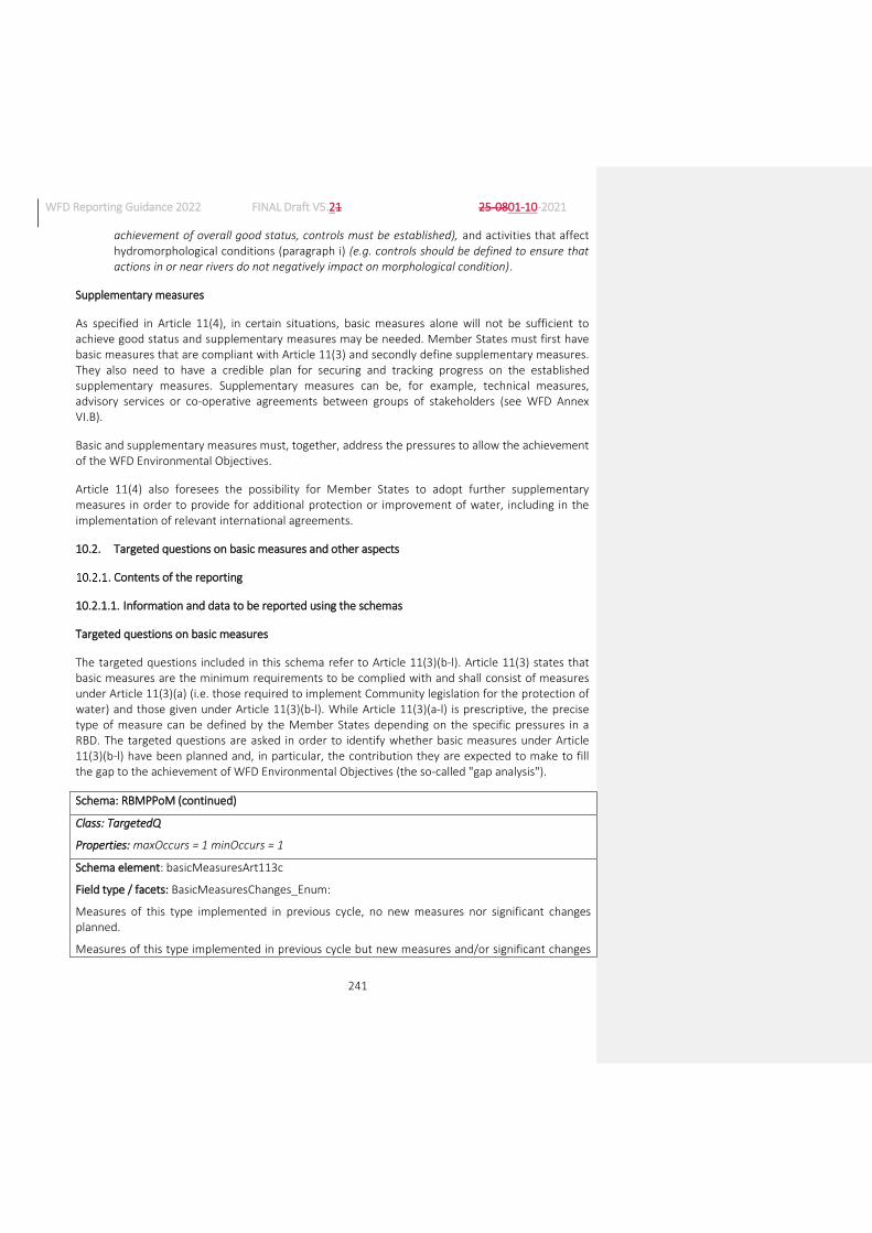
WFD Reporting Guidance 2022 FINAL Draft V5.21 25-0801-10-2021
241
achievement of overall good status, controls must be established), and activities that affect hydromorphological conditions (paragraph i) (e.g. controls should be defined to ensure that actions in or near rivers do not negatively impact on morphological condition).
Supplementary measures
As specified in Article 11(4), in certain situations, basic measures alone will not be sufficient to achieve good status and supplementary measures may be needed. Member States must first have basic measures that are compliant with Article 11(3) and secondly define supplementary measures. They also need to have a credible plan for securing and tracking progress on the established supplementary measures. Supplementary measures can be, for example, technical measures, advisory services or co-operative agreements between groups of stakeholders (see WFD Annex VI.B).
Basic and supplementary measures must, together, address the pressures to allow the achievement of the WFD Environmental Objectives.
Article 11(4) also foresees the possibility for Member States to adopt further supplementary measures in order to provide for additional protection or improvement of water, including in the implementation of relevant international agreements.
10.2. Targeted questions on basic measures and other aspects
Contents of the reporting
10.2.1.1. Information and data to be reported using the schemas
Targeted questions on basic measures
The targeted questions included in this schema refer to Article 11(3)(b-l). Article 11(3) states that basic measures are the minimum requirements to be complied with and shall consist of measures under Article 11(3)(a) (i.e. those required to implement Community legislation for the protection of water) and those given under Article 11(3)(b-l). While Article 11(3)(a-l) is prescriptive, the precise type of measure can be defined by the Member States depending on the specific pressures in a RBD. The targeted questions are asked in order to identify whether basic measures under Article 11(3)(b-l) have been planned and, in particular, the contribution they are expected to make to fill the gap to the achievement of WFD Environmental Objectives (the so-called "gap analysis").
Schema: RBMPPoM (continued)
Class: TargetedQ
Properties: maxOccurs = 1 minOccurs = 1
Schema element: basicMeasuresArt113c
Field type / facets: BasicMeasuresChanges_Enum:
Measures of this type implemented in previous cycle, no new measures nor significant changes planned.
Measures of this type implemented in previous cycle but new measures and/or significant changes

WFD Reporting Guidance 2022 FINAL Draft V5.21 25-0801-10-2021
242
planned.
No measures of this type implemented in previous cycle but new measures and/or significant changes planned.
No measures of this type implemented in previous cycle and no measures planned.
Properties: maxOccurs = 1 minOccurs = 1
Guidance on completion of schema element: Required. Indicate whether there are measures promoting efficient and sustainable water use in order to avoid compromising the achievement of the objectives specified in Article 4 (e.g. water metering and allocations) (Article 11(3)(c)).
Schema element: basicMeasuresArt113d
Field type / facets: BasicMeasuresArt113d_Enum:
There are safeguard zones and there are no plans to change the regulations as a result of this RBMP.
There are safeguard zones but there will be significant changes to them implemented as a result of this RBMP.
There are no safeguard zones but there are plans to implement them as a result of this RBMP.
There are no safeguard zones and no plans to establish them.
Properties: maxOccurs = 1 minOccurs = 1
Guidance on completion of schema element: Required. Indicate whether there are measures to meet the requirements of Article 7, including measures to safeguard water quality in order to reduce the level of purification treatment required for the production of drinking water (Article 11(3)(d)).
Schema element: basicMeasuresArt113ePermit
Field type / facets: BasicMeasures_Enum:
Yes, for surface and groundwater.
Yes, for surface water only.
Yes, for groundwater only.
No.
Properties: maxOccurs = 1 minOccurs = 1
Guidance on completion of schema element: Required. Indicate whether there is a concession, authorisation and/or permitting regime to control water abstractions (Article 11(3)(e)).
Schema element: basicMeasuresArt113eRegister
Field type / facets: BasicMeasures_Enum:
Yes, for surface and groundwater.
Yes, for surface water only.
Yes, for groundwater only.
No.

WFD Reporting Guidance 2022 FINAL Draft V5.21 25-0801-10-2021
243
Properties: maxOccurs = 1 minOccurs = 1
Guidance on completion of schema element: Required. Indicate whether there is a register of abstractions (Article 11(3)(e)).
Schema element: basicMeasuresArt113eThreshold
Field type / facets: BasicMeasuresArt113eThreshold_Enum:
Yes, small abstractions are exempted from controls.
Small abstractions do not require permits but are all registered.
No, there are no thresholds.
Properties: maxOccurs = 1 minOccurs = 0
Guidance on completion of schema element: Conditional. If there is a concession / authorisation / permitting regime and/or a register, indicate whether there are thresholds below which abstractions do not require permits and are not subject to registration (Article 11(3)(e)).
Quality checks: Conditional check: Report if and only if basicMeasuresArt113ePermit and/or basicMeasuresArt113eRegister are ‘Yes,…’.
Schema element: basicMeasuresArt113eImpoundment
Field type / facets: BasicMeasuresArt113eImpoundment_Enum:
Yes, there is a concession, authorisation and/or permitting regime to control water impoundment and a register of impoundments.
There is a concession, authorisation and/or permitting regime to control water impoundment but no register of impoundments.
There is no concession, authorisation nor permitting regime to control water impoundment but there is a register of impoundments.
No, there is no concession, authorisation nor permitting regime to control water impoundment and no register of impoundments.
Properties: maxOccurs = 1 minOccurs = 1
Guidance on completion of schema element: Required. Indicate whether there is a concession, authorisation and/or permitting regime to control water impoundment, and/or a register of impoundments (Article 11(3)(e)).
Schema element: basicMeasuresArt113f
Field type / facets: BasicMeasuresChanges_Enum:
Measures of this type implemented in previous cycle, no new measures nor significant changes planned.
Measures of this type implemented in previous cycle but new measures and/or significant changes planned.
No measures of this type implemented in previous cycle but new measures and/or significant changes planned.
No measures of this type implemented in previous cycle and no measures planned.

WFD Reporting Guidance 2022 FINAL Draft V5.21 25-0801-10-2021
244
Properties: maxOccurs = 1 minOccurs = 1
Guidance on completion of schema element: Required. Indicate whether controls are in place, including a requirement for prior authorisation, of artificial recharge or augmentation of groundwater bodies (Article 11(3)(f)).
Schema element: basicMeasuresArt113gPermit
Field type / facets: BasicMeasures_Enum:
Yes, for surface and groundwater.
Yes, for surface water only.
Yes, for groundwater only.
No.
Properties: maxOccurs = 1 minOccurs = 1
Guidance on completion of schema element: Required. Indicate whether there is an authorisation and/or permitting regime to control waste water point source discharges (Article 11(3)(g)).
Schema element: basicMeasuresArt113gRegister
Field type / facets: BasicMeasures_Enum:
Yes, for surface and groundwater.
Yes, for surface water only.
Yes, for groundwater only.
No.
Properties: maxOccurs = 1 minOccurs = 1
Guidance on completion of schema element: Required. Indicate whether there is a register of waste water point source discharges (Article 11(3)(g)).
Schema element: basicMeasuresArt113gThreshold
Field type / facets: BasicMeasuresArt113gThreshold_Enum:
Yes, small discharges are exempted from controls.
Small discharges do not require permits but are all registered.
No, there are no thresholds.
Properties: maxOccurs = 1 minOccurs = 0
Guidance on completion of schema element: Conditional. If there is an authorisation / permitting regime and/or a register of waste water point source discharges, indicate whether there are thresholds below which waste water discharges do not require permits and are not subject to registration (Article 11(3)(g)).
Quality checks: Conditional check: Report if and only if basicMeasuresArt113gPermit and/or basicMeasuresArt113gRegister are ‘Yes,…’.
Schema element: basicMeasuresArt113hRules
Field type / facets: BasicMeasuresArt113hRules_Enum:

WFD Reporting Guidance 2022 FINAL Draft V5.21 25-0801-10-2021
245
Yes, same rules apply across the whole RBD.
Yes, but rules apply only in Nitrate Vulnerable Zones.
Yes, but there are differentiated rules for different parts of the RBD.
No general binding rules.
Properties: maxOccurs = 1 minOccurs = 1
Guidance on completion of schema element: Required. Indicate whether there are general binding rules for the control of diffuse pollution from agriculture.
Schema element: basicMeasuresArt113hIssues
Field type / facets: BasicMeasuresArt113hIssues_Enum:
Nitrates
Phosphorus
Pesticides
Sediments
Organic pollution
Chemical pollution
Pharmaceuticals
Microbiological/bacteriological pollution
Other pollutants
Properties: maxOccurs = unbounded minOccurs = 0
Guidance on completion of schema element: Conditional. If there are general binding rules, report the issues that they cover.
Quality checks: Conditional check: Report if and only if basicMeasuresArt113hRules is ‘Yes,…’.
Schema element: basicMeasuresArt113iPermit
Field type / facets: YesNoCode_Enum: Yes, No
Properties: maxOccurs = 1 minOccurs = 1
Guidance on completion of schema element: Required. Indicate whether there is an authorisation and/or permitting regime to control physical modifications to water bodies.
Schema element: basicMeasuresArt113iRiparian
Field type / facets: YesNoCode_Enum: Yes, No
Properties: maxOccurs = 1 minOccurs = 0
Guidance on completion of schema element: Conditional. If there is an authorisation and/or permitting regime to control physical modifications to the water bodies, indicate whether the regime covers changes to the riparian area of water bodies.
Quality checks: Conditional check: Report if and only if basicMeasuresArt113iPermit is ‘Yes’.
Schema element: basicMeasuresArt113iRegister

WFD Reporting Guidance 2022 FINAL Draft V5.21 25-0801-10-2021
246
Field type / facets: YesNoCode_Enum: Yes, No
Properties: maxOccurs = 1 minOccurs = 1
Guidance on completion of schema element: Required. Indicate whether there is a register of physical modifications of water bodies.
Schema element: basicMeasuresArt113j
Field type / facets: BasicMeasuresArt113j_Enum:
Yes, there is a prohibition of all direct discharges.
Some direct discharges are authorised in accordance with Article 11(3)(j).
No, there is no prohibition of direct discharges.
Properties: maxOccurs = 1 minOccurs = 1
Guidance on completion of schema element: Required. Indicate whether there is a prohibition of direct discharges (Article 11(3)(j)).
Schema element: basicMeasuresArt113k
Field type / facets: YesNoCode_Enum: Yes, No
Properties: maxOccurs = 1 minOccurs = 1
Guidance on completion of schema element: Required. Indicate whether, in accordance with action taken pursuant to Article 16, there are measures to eliminate pollution of surface waters by Priority Substances and to progressively reduce pollution by other substances which would otherwise prevent Member States from achieving the Environmental Objectives set out in Article 4 (Article 11(3)(k)).
Schema element: basicMeasuresArt113b-lReference
Field type / facets: ReferenceType (see Annex 9)
Properties: maxOccurs = unbounded minOccurs = 1
Guidance on completion of schema element: Required. Provide references or hyperlinks to the relevant document and section where specific information can be found on the application of basic measures (Article 11(3)(b-l)). Guidance on what should be included in this document is provided in Section 10.2.1.210.2.1.2.
Targeted questions on other aspects
Schema: RBMPPoM (continued)
Class: TargetedQ (continued)
Properties: maxOccurs = 1 minOccurs = 1
Schema element: waterReUseMeasure
Field type / facets: YesNoCode_Enum: Yes, No
Properties: maxOccurs = 1 minOccurs = 1
Guidance on completion of schema element: Required. Indicate whether re-use of water has been
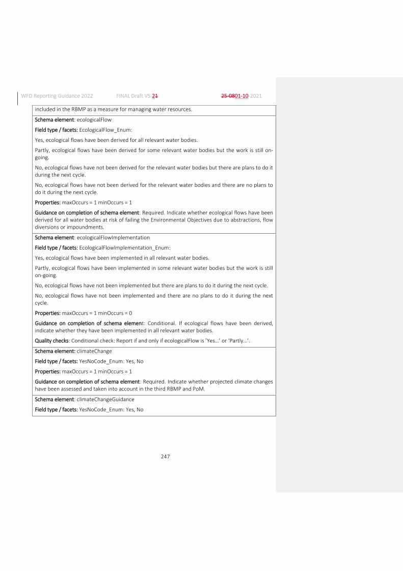
WFD Reporting Guidance 2022 FINAL Draft V5.21 25-0801-10-2021
247
included in the RBMP as a measure for managing water resources.
Schema element: ecologicalFlow
Field type / facets: EcologicalFlow_Enum:
Yes, ecological flows have been derived for all relevant water bodies.
Partly, ecological flows have been derived for some relevant water bodies but the work is still on-going.
No, ecological flows have not been derived for the relevant water bodies but there are plans to do it during the next cycle.
No, ecological flows have not been derived for the relevant water bodies and there are no plans to do it during the next cycle.
Properties: maxOccurs = 1 minOccurs = 1
Guidance on completion of schema element: Required. Indicate whether ecological flows have been derived for all water bodies at risk of failing the Environmental Objectives due to abstractions, flow diversions or impoundments.
Schema element: ecologicalFlowImplementation
Field type / facets: EcologicalFlowImplementation_Enum:
Yes, ecological flows have been implemented in all relevant water bodies.
Partly, ecological flows have been implemented in some relevant water bodies but the work is still on-going.
No, ecological flows have not been implemented but there are plans to do it during the next cycle.
No, ecological flows have not been implemented and there are no plans to do it during the next cycle.
Properties: maxOccurs = 1 minOccurs = 0
Guidance on completion of schema element: Conditional. If ecological flows have been derived, indicate whether they have been implemented in all relevant water bodies.
Quality checks: Conditional check: Report if and only if ecologicalFlow is ’Yes…’ or ‘Partly…’.
Schema element: climateChange
Field type / facets: YesNoCode_Enum: Yes, No
Properties: maxOccurs = 1 minOccurs = 1
Guidance on completion of schema element: Required. Indicate whether projected climate changes have been assessed and taken into account in the third RBMP and PoM.
Schema element: climateChangeGuidance
Field type / facets: YesNoCode_Enum: Yes, No

WFD Reporting Guidance 2022 FINAL Draft V5.21 25-0801-10-2021
248
Properties: maxOccurs = 1 minOccurs = 0
Guidance on completion of schema element: Conditional. If climate change has been taken into account, indicate whether the CIS Guidance Document No. 24 ‘River basin in a changing climate’126 has been used for this purpose.
Quality checks: Conditional check: Report if and only if climateChange is ‘Yes’.
Schema element: climateChangeAspectsConsidered
Field type / facets: ClimateChangeAspectsConsidered_Enum:
Assessing direct and indirect climate pressures
Detecting climate change signals
Monitoring change at reference sites
Setting objectives
Forecasting the economics of water supply and demand
Checking the effectiveness of measures
Preferential selection of robust adaptation measures
Maximisation of cross-sectoral benefits and minimisation of negative effects across sectors
Flood risk management
Drought management and water scarcity
Properties: maxOccurs = unbounded minOccurs = 0
Guidance on completion of schema element: Conditional. If climate change has been taken into account, select from the enumeration list the aspects that have been undertaken or considered in the third RBMP and PoM.
Quality checks: Conditional check: Report if and only if climateChange is ‘Yes’.
Schema element: floodsDirective
Field type / facets: YesNoCode_Enum: Yes, No
Properties: maxOccurs = 1 minOccurs = 1
Guidance on completion of schema element: Required. The Floods Directive requires the development of the Flood Risk Management Plans to be carried out in co-ordination with the review of the RBMPs. Indicate whether the objectives and requirements of the Floods Directive have been considered in the third RBMP and PoM.
Schema element: winWinNWRMDroughtsFloods
Field type / facets: YesNoCode_Enum: Yes, No
Properties: maxOccurs = 1 minOccurs = 1
Guidance on completion of schema element: Required. Indicate whether specific win-win measures in terms of achieving the objectives of the WFD and Floods Directive, drought management and use
126 https://circabc.europa.eu/sd/a/a88369ef-df4d-43b1-8c8c-306ac7c2d6e1/Guidance%20document%20n%2024%20-
%20River%20Basin%20Management%20in%20a%20Changing%20Climate_FINAL.pdf

WFD Reporting Guidance 2022 FINAL Draft V5.21 25-0801-10-2021
249
of Natural Water Retention Measures (NWRM) have been included in the PoM.
Schema element: structuralMeasures
Field type / facets: YesNoCode_Enum: Yes, No
Properties: maxOccurs = 1 minOccurs = 1
Guidance on completion of schema element: Required. Indicate whether the design of new and existing structural measures, such as flood defences, storage dams and tidal barriers, have been adapted to take into account WFD Environmental Objectives.
Schema element: msfdCoOrdination
Field type / facets: YesNoNotrelevantType_Union_Enum: Yes, No, Not relevant
Properties: maxOccurs = 1 minOccurs = 1
Guidance on completion of schema element: Required. Indicate whether the preparations of the RBMP and PoM have been co-ordinated with the implementation of the Marine Strategy Framework Directive. Report ‘Not relevant’ for the French Overseas Territories and for landlocked countries if there was no coordination with the MSFD. Please note, however, that measures taken in a landlocked country may well be relevant for the MSFD (e.g. reduction of nutrients in rivers may have an impact on eutrophication in marine waters). If this possible relevance was considered, you should report ‘Yes’ or ‘No’.
Schema element: msfdAssessment
Field type / facets: YesNoNotrelevantType_Union_Enum: Yes, No, Not relevant
Properties: maxOccurs = 1 minOccurs = 1
Guidance on completion of schema element: Required. Indicate whether the need for additional measures or more stringent measures beyond those required by the WFD, in order to contribute to the achievement of the relevant MSFD objectives in coastal and marine environments, have been considered in the PoM. Report ‘Not relevant’ for the French Overseas Territories and for landlocked countries if there was no coordination with the MSFD. Please note, however, that measures taken in a landlocked country may well be relevant for the MSFD (e.g. reduction of nutrients in rivers may have an impact on eutrophication in marine waters). If this possible relevance was considered, you should report ‘Yes’ or ‘No’.
Schema element: msfdMeasuresNeeded
Field type / facets: MSFDMeasuresNeeded_Enum:
Nutrients
Chemicals
Litter
Others
None
Properties: maxOccurs = unbounded minOccurs = 0
Guidance on completion of schema element: Conditional. If the need for additional measures or more stringent measures beyond those required by the WFD, in order to achieve the relevant MSFD objectives in coastal and marine environments, have been considered in the PoM, select from the

WFD Reporting Guidance 2022 FINAL Draft V5.21 25-0801-10-2021
250
enumeration list the additional measures needed to meet the MSFD objectives. ‘None’ should be selected if the need for additional measures was considered but the conclusion was that no additional measures are needed.
Quality checks: Conditional check: Report if and only if msfdAssessment is ‘Yes’.
Schema element: otherAspectsReference
Field type / facets: ReferenceType (see Annex 9)
Properties: maxOccurs = unbounded minOccurs = 0
Guidance: Conditional. Provide references or hyperlinks to the documents and sections where specific information can be found on the other aspects concerned by the targeted questions above. Guidance on what should be included in this document is provided in Section 10.2.1.210.2.1.2.
Quality checks: Conditional check: Report if and only if at least one of the following elements have been reported with the following values:, waterReUseMeasure is 'Yes', ecologicalFlow is 'Yes…' or 'Partly…', climateChange is 'Yes', floodsDirective is 'Yes', winWinNWRMDroughtsFloods is 'Yes', structuralMeasures is 'Yes', msfdCoOrdination is 'Yes' or msfdAssessment is 'Yes'.
10.2.1.2. Guidance on the contents of RBMPs/background documents
The following provides guidance on aspects that the European Commission expects to find in the relevant chapters on basic measures in the RBMPs or in background documents. This guidance is not intended to be exhaustive in terms of what the Member States have to include in their RBMPs or background documents, but rather to provide certain concrete elements of information that the European Commission expects to find.
Basic measures
The information required for individual measures is described in section 10.1.8.2, and this obviously applies also to basic measures. This section specifies further information that is required for certain types of basic measures. This information may be included in the RBMPs or in background documents made available to the European Commission.
It is recommended that Member States develop templates to include relevant information for each measure (see section 10.1.8.2). In order to simplify the presentation, several measures contributing to the same purpose under Articles 11(3)(b-l) may be included in the same template.
In describing the measures, it is important to make clear what has already been implemented and what is planned for the next cycle. Member States should ensure that the description of the basic measures includes at least the following information:
For measures under Article 11(3)(d) for the protection of water abstractions used for the protection of drinking water, include in the description of the measure, where relevant:
o General size of the safeguard zones or criteria for their establishment.
o Types of bans or restrictions that are in force in safeguard zones (e.g. on the application of pesticides, fertilisers/manure, building and industrial activities).
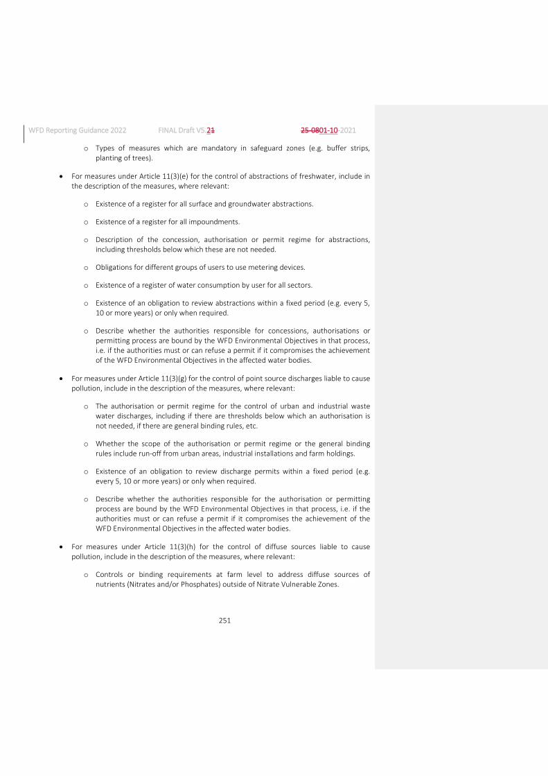
WFD Reporting Guidance 2022 FINAL Draft V5.21 25-0801-10-2021
251
o Types of measures which are mandatory in safeguard zones (e.g. buffer strips, planting of trees).
For measures under Article 11(3)(e) for the control of abstractions of freshwater, include in the description of the measures, where relevant:
o Existence of a register for all surface and groundwater abstractions.
o Existence of a register for all impoundments.
o Description of the concession, authorisation or permit regime for abstractions, including thresholds below which these are not needed.
o Obligations for different groups of users to use metering devices.
o Existence of a register of water consumption by user for all sectors.
o Existence of an obligation to review abstractions within a fixed period (e.g. every 5, 10 or more years) or only when required.
o Describe whether the authorities responsible for concessions, authorisations or permitting process are bound by the WFD Environmental Objectives in that process, i.e. if the authorities must or can refuse a permit if it compromises the achievement of the WFD Environmental Objectives in the affected water bodies.
For measures under Article 11(3)(g) for the control of point source discharges liable to cause pollution, include in the description of the measures, where relevant:
o The authorisation or permit regime for the control of urban and industrial waste water discharges, including if there are thresholds below which an authorisation is not needed, if there are general binding rules, etc.
o Whether the scope of the authorisation or permit regime or the general binding rules include run-off from urban areas, industrial installations and farm holdings.
o Existence of an obligation to review discharge permits within a fixed period (e.g. every 5, 10 or more years) or only when required.
o Describe whether the authorities responsible for the authorisation or permitting process are bound by the WFD Environmental Objectives in that process, i.e. if the authorities must or can refuse a permit if it compromises the achievement of the WFD Environmental Objectives in the affected water bodies.
For measures under Article 11(3)(h) for the control of diffuse sources liable to cause pollution, include in the description of the measures, where relevant:
o Controls or binding requirements at farm level to address diffuse sources of nutrients (Nitrates and/or Phosphates) outside of Nitrate Vulnerable Zones.
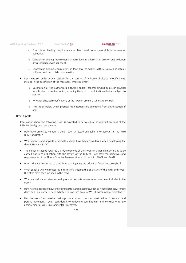
WFD Reporting Guidance 2022 FINAL Draft V5.21 25-0801-10-2021
252
o Controls or binding requirements at farm level to address diffuse sources of pesticides.
o Controls or binding requirements at farm level to address soil erosion and pollution of water bodies with sediment.
o Controls or binding requirements at farm level to address diffuse sources of organic pollution and microbial contamination.
For measures under Article 11(3)(i) for the control of hydromorphological modifications, include in the description of the measures, where relevant:
o Description of the authorisation regime and/or general binding rules for physical modifications of water bodies, including the type of modifications that are subject to control.
o Whether physical modifications of the riparian area are subject to control.
o Thresholds below which physical modifications are exempted from authorisation, if any.
Other aspects
Information about the following issues is expected to be found in the relevant sections of the RBMP or background documents.
How have projected climate changes been assessed and taken into account in the third RBMP and PoM?
What aspects and impacts of climate change have been considered when developing the third RBMP and PoM?
The Floods Directive requires the development of the Flood Risk Management Plans to be carried out in co-ordination with the review of the RBMPs. How have the objectives and requirements of the Floods Directive been considered in the third RBMP and PoM?
How is the PoM expected to contribute to mitigating the effects of floods and droughts?
What specific win-win measures in terms of achieving the objectives of the WFD and Floods Directive have been included in the PoM?
What natural water retention and green infrastructure measures have been included in the PoM?
How has the design of new and existing structural measures, such as flood defences, storage dams and tidal barriers, been adapted to take into account WFD Environmental Objectives?
Has the use of sustainable drainage systems, such as the construction of wetland and porous pavements, been considered to reduce urban flooding and contribute to the achievement of WFD Environmental Objectives?

WFD Reporting Guidance 2022 FINAL Draft V5.21 25-0801-10-2021
253
Provide details of the application of Article 4(7) of the WFD for new flood defence projects and infrastructure.
Provide details on the co-ordination of the public participation and stakeholder consultation during the development of RBMPs and Flood Risk Management Plans.
Explain whether the need for a specific drought management was considered and, if it was done, what was the process followed for ites development.
Explain how measures designed to improve the efficiency of water use have been planned, particularly in relation to their use and prioritisation instead of alternative infrastructure measures to increase supply.
Explain how the re-use of water (e.g. from waste water treatment or industrial installations) has been included as a measure in terms of managing water resources, particularly in terms of its magnitude and its expected effects on water abstractions and the need for demand management or infrastructure supply measures.
Explain how the relevant measures being planned for compliance with the Marine Strategy Framework Directive (2008/56/EC)127 have been taken into account in the WFD PoM.
10.3. Estimates of cost of measures
Introduction
Article 19 of the WFD requires the European Commission to review the Directive and to propose any necessary amendments. As a part of this review, the European Commission needs to be able to assess the costs and benefits of the implementation of the Directive.
How will the European Commission and the EEA use the information reported?
The European Commission will use the information reported to ensure that Member States are implementing the WFD appropriately and consistently.
This information will allow the Commission to identify any financial barriers that may be obstructing implementation and to identify the costs of implementation at RBD, Member State and EU level, which is expected to allow for a cost-effectiveness analysis of the WFD.
A full cost-effectiveness analysis would require a level of harmonisation in the data reported by Member States that did not exist in previous RBMPs. This is at least partly due to difficulties for water authorities in the Member States to collect this type of information with a similar structure, but also, for example, to different accounting rules in different Member States. It is therefore likely that full harmonisation will still not be possible in the reporting of the third RBMPs. It is also likely that in some cases the reported values are the best available estimates at the time of reporting. However, if the information reported by Member States is accurately described (e.g. does the cost reported include figures for public sector investment, private sector or both, what is the
127 http://eur-lex.europa.eu/legal-content/EN/TXT/PDF/?uri=CELEX:32008L0056&qid=1440766714959&from=EN

WFD Reporting Guidance 2022 FINAL Draft V5.21 25-0801-10-2021
254
depreciation period for the type of investments taking place, etc) this information will already be essential for any cost-effectiveness work being done by the Commission.
Statistics and information will be provided to the European Parliament at EU level. Information will be provided to the public through WISE.
10.3.2.1. Products from reporting
The products from reporting will, in this case, depend largely on the level of harmonisation that will be reached in the way the reporting is done. Given the issues indicated above, it is unlikely that aggregation of figures at EU level will be feasible in a meaningful way, so the aggregation will probably be limited to the Member State level. The reporting will mostly be used, together with the information provided in the RBMPs and background documents, in the analyses that will be done by the Commission.
Contents of the reporting
10.3.3.1. Information and data to be reported using the schema
Schema: RBMPPoM (continued)
Class: Costs
Properties: maxOccurs = 1 minOccurs = 1
Schema element: costOfMeasuresScale20152021
Field type / facets: MSorRBD_Enum:
Member State
RBD
Properties: maxOccurs = 1 minOccurs = 1
Guidance on completion of schema element: Required. Indicate whether the costs reported refer to the RBD or to the Member State as a whole.
Schema element: costOfMeasuresPeriod20152021
Field type / facets: YearRangeType
Properties: maxOccurs = 1 minOccurs = 1
Guidance on completion of schema element: Required. Report the period (e.g. 2015--2021, 2015--2020, etc) to which the reported costs refer.
Schema element: investmentCosts20152021
Field type / facets: NumberDecimalType
Properties: maxOccurs = 1 minOccurs = 1
Guidance on completion of schema element: Required. Report the total investment expenditure (in millions of Euros) in measures under Articles 11(3), 11(4) and 11(5) that were effectively implemented during the previous planning cycle.
Report -9999 if this information is not available.Expenditure should not be annualised.

WFD Reporting Guidance 2022 FINAL Draft V5.21 25-0801-10-2021
255
Schema element: costExplanation20152021Reference
Field type / facets: ReferenceType (see Annex 9)
Properties: maxOccurs = unbounded minOccurs = 1
Guidance on completion of schema element: Required. Provide references or hyperlinks to the relevant documents and sections where specific information can be found on how the costs reported for the previous planning cycle have been calculated.
Guidance on what should be included in this document is provided in 10.3.3.2.
Schema element: costOfMeasuresScale20212027
Field type / facets: MSorRBD_Enum:
Member State
RBD
Properties: maxOccurs = 1 minOccurs = 1
Guidance on completion of schema element: Required. Indicate whether the costs reported refer to the RBD or to the Member State as a whole.
Schema element: costOfMeasurePeriod20212027
Field type / facets: YearRangeType
Properties: maxOccurs = 1 minOccurs = 1
Guidance on completion of schema element: Required. Report the year (in the format YYYY) or period (in the format YYYY--YYYY) that was used as the basis for the calculation of costs.
Schema element: investmentCosts20212027
Field type / facets: NumberDecimalType
Properties: maxOccurs = 1 minOccurs = 1
Guidance on completion of schema element: Required. Report the total investment expenditure (in millions of Euros) in planned measures under Articles 11(3), 11(4) and 11(5) during the next planning cycle.
Report -9999 if this information is not available. Expenditure should not be annualised.
Schema element: annualCosts20212027
Field type / facets: NumberDecimalType
Properties: maxOccurs = 1 minOccurs = 1
Guidance on completion of schema element: Required. Report the total annual operation and maintenance costs and any other annual costs (in millions of Euros) of planned measures under Articles 11(3), 11(4) and 11(5) during the next planning cycle.
Total annual costs should, in principle, exclude depreciation (see guidance on the schema element depreciation20212027).
Report -9999 if this information is not available
Schema element: depreciation20212027

WFD Reporting Guidance 2022 FINAL Draft V5.21 25-0801-10-2021
256
Field type / facets: YesNoCode_Enum: Yes, No
Properties: maxOccurs = 1 minOccurs = 1
Guidance on completion of schema element: Required. Indicate whether depreciation is included in the total annual costs reported in annualCosts20212027. The default selection should be ‘No’ (i.e. depreciation should be excluded from the total annual costs).
Schema element: costExplanation20212027Reference
Field type / facets: ReferenceType (see Annex 9)
Properties: maxOccurs = unbounded minOccurs = 1
Guidance on completion of schema element: Required. Provide references or hyperlinks to the relevant documents and sections where specific information can be found on how the costs reported for the next planning cycle have been calculated.
Guidance on what should be included in this document is provided in Section 10.3.3.210.3.3.2.
Financing of measures
The Programmes of Measures contain different instruments (legal, administrative, technical, infrastructure, training, etc) and are potentially funded in different ways. The public budget is expected to cover part of the cost of the measures but also private operators are expected to provide funds (e.g. through the cost recovery provisions). European funds, such as Structural, Cohesion or CAP funds, can also contribute to financing some of the measures.
Schema: RBMPPoM (continued)
Class: Costs
Properties: maxOccurs = 1 minOccurs = 1
Schema element: euFunds20152021
Field type / facets: String25Type
Properties: maxOccurs = 1 minOccurs = 1
Guidance on completion of schema element: Required. Report, as an estimated cost or range, the total investment in the Programme of Measures for the previous planning cycle that was financed by EU funds.
Report -9999 if this information is not available.
Schema element: euFunds20212027
Field type / facets: String25Type
Properties: maxOccurs = 1 minOccurs = 1
Guidance on completion of schema element: Required. Report, as an estimated cost or range, the total investment in the Programme of Measures for the next planning cycle that is expected to be

WFD Reporting Guidance 2022 FINAL Draft V5.21 25-0801-10-2021
257
financed by EU funds.
Report -9999 if this information is not available.
10.3.3.2. Guidance on the contents of RBMPs/background documents
The following provides guidance on aspects that the European Commission expects to find in the relevant chapters on costs of meaasures in the RBMPs or in background documents. This guidance is not intended to be exhaustive in terms of what the Member States have to include in their RBMPs or background documents, but rather to provide certain concrete elements of information that the European Commission expects to find.
The RBMP and background documents must explain how the costs of measures have been calculated. This should include, at least:
Calculation methods for assessing costs.
Which costs were included or excluded.
Whether the reported costs include only public budget or also costs for private operators.
Supporting explanation on factors affecting the costs of measures.
If available, present an estimate of the share of costs of measures foreseen in the previous PoM that could not be implemented and have therefore been transferred to the new PoM. Please include an explanation of the factors that explain this situation, in overall terms and for specific sectors (see WFD Annex VII.B.3).
If available, include projections of investment expenditure for the planning cycle 2027-2033.
10.4. Co-ordination of measures in international RBDs
Introduction
The WFD requires co-ordination of the Programmes of Measures in transboundary River Basin Districts.
How will the European Commission and the EEA use the information reported?
The European Commission will use the information reported to assess whether the PoMs have been sufficiently co-ordinated in transboundary RBDs.
Statistics and information will be provided to the European Parliament at EU level. Information will be provided to the public through WISE.
10.4.2.1. Products from reporting
The following list identifies some of the products which will be produced by the European Commission or the EEA from the data and information reported by Member States.

WFD Reporting Guidance 2022 FINAL Draft V5.21 25-0801-10-2021
258
Nb Name of product Type of product
Scale of information*
Detailed information displayed
Source of detailed information and aggregation rule
1 Degree of co-ordination of PoMs in IRBDs
Chart Table or Map
EU/MS/RBD/IRBD Information reported at RBD/IRBD level.
2 Number of co-ordinated measures to tackle river continuity, nutrient reduction and chemical pollution in each IRBP
Chart or Table
EU/MS/RBD/IRBD Information reported at RBD/IRBD level.
3 Number of specific key activities co-ordinated, partially co-ordinated, not co-ordinated or not specified in each IRBP
Chart or Table
Chart or Table Information reported at RBD/IRBD level.
Contents of the reporting
10.4.3.1. Information and data to be reported using the schemas
Information on international co-ordination of the PoMs should be reported at the level of the RBD, only when the national RBD being reported is part of a larger international one, as reported in the schema RBDSUCA.
Schema: RBMPPoM (continued)
Class: CoOrd
Properties: maxOccurs = 1 minOccurs = 0
Quality checks: Conditional check: Report if and only if RBDSUCA/RBD/internationalRBD is ‘Yes’.
Schema element: pomCoOrdinationJointVision
Field type / facets: Coord_Enum:
Yes with other MS,
Yes with countries outside the EU,
Yes with other MS and countries outside the EU,
No

WFD Reporting Guidance 2022 FINAL Draft V5.21 25-0801-10-2021
259
Properties: maxOccurs = 1 minOccurs = 1
Guidance on completion of schema element: Required128. Have joint visions and management objectives been established for the coordination of the Programmes of Measures?
Schema element: pomCoOrdinationArt5SWMI
Field type / facets: Coord_Enum:
Yes with other MS,
Yes with countries outside the EU,
Yes with other MS and countries outside the EU,
No
Properties: maxOccurs = 1 minOccurs = 1
Guidance on completion of schema element: Required128124. Has the Article 5 analysis and identification of Significant Water Management Issues been co-ordinated in the development of the Programmes of Measures?
Schema element: pomCoOrdinationIRBMPPoM
Field type / facets: Coord_Enum:
Yes with other MS,
Yes with countries outside the EU,
Yes with other MS and countries outside the EU,
No
Properties: maxOccurs = 1 minOccurs = 1
Guidance on completion of schema element: Required128124. Have international RBMP and PoM been produced, incorporating all relevant Member States?
Schema element: pomCoOrdinationRoofReport
Field type / facets: Coord_Enum:
Yes with other MS,
Yes with countries outside the EU,
Yes with other MS and countries outside the EU,
No
Properties: maxOccurs = 1 minOccurs = 1
Guidance on completion of schema element: Required128124. Has an international Roof Report (or A-plan) covering all relevant Member States been prepared based on the national River Basin Management Plans (or B-plans)?
Schema element: pomCoOrdinationLinks
128 Please note that the multiplicity of the Class CoOrd is 0 to many. Therefore, if the RBD is not part of an international
RBD, this whole class does not need to be reported.

WFD Reporting Guidance 2022 FINAL Draft V5.21 25-0801-10-2021
260
Field type / facets: Coord_Enum:
Yes with other MS,
Yes with countries outside the EU,
Yes with other MS and countries outside the EU,
No
Properties: maxOccurs = 1 minOccurs = 0
Guidance on completion of schema element: Conditional. If an international RBMP has been produced, have explicit links with national RBMPs been made within the international RBMP?
Quality checks: Conditional check: Report if and only if pomCoOrdinationIRBMPPoM is ‘Yes…’.
Schema element: pomCoOrdinationSectors
Field type / facets: Coord_Enum:
Yes with other MS,
Yes with countries outside the EU,
Yes with other MS and countries outside the EU,
No
Properties: maxOccurs = 1 minOccurs = 1
Guidance on completion of schema element: Required128124. Has there been sectoral and stakeholder involvement within the international co-ordination mechanisms?
Schema element: pomCoOrdinationTransparency
Field type / facets: Coord_Enum:
Yes with other MS,
Yes with countries outside the EU,
Yes with other MS and countries outside the EU,
No
Properties: maxOccurs = 1 minOccurs = 1
Guidance on completion of schema element: Required128124. Has there been transparency of international co-ordination to stakeholders and others?
Schema element: pomCoOrdinationFinancial
Field type / facets: Coord_Enum:
Yes with other MS,
Yes with countries outside the EU,
Yes with other MS and countries outside the EU,
No
Properties: maxOccurs = 1 minOccurs = 1
Guidance on completion of schema element: Required128124. Have financial resources for joint co-

WFD Reporting Guidance 2022 FINAL Draft V5.21 25-0801-10-2021
261
operation been made available?
Schema element: iRBMPIssuesNutrient
Field type / facets: YesNoCode_Enum: Yes, No
Properties: maxOccurs = 1 minOccurs = 0
Guidance on completion of schema element: Conditional. If an international RBMP has been produced, does it address nutrient pollution?
Quality checks: Conditional check: Report if and only if pomCoOrdinationIRBMPPoM is ‘Yes…’.
Schema element: iRBMPIssuesSediment
Field type / facets: YesNoCode_Enum: Yes, No
Properties: maxOccurs = 1 minOccurs = 0
Guidance on completion of schema element: Conditional. If an international RBMP has been produced, does it address sediment management?
Quality checks: Conditional check: Report if and only if pomCoOrdinationIRBMPPoM is ‘Yes…’.
Schema element: iRBMPIssuesChemical
Field type / facets: YesNoCode_Enum: Yes, No
Properties: maxOccurs = 1 minOccurs = 0
Guidance on completion of schema element: Conditional. If an international RBMP has been produced, does it address chemical pollution?
Quality checks: Conditional check: Report if and only if pomCoOrdinationIRBMPPoM is ‘Yes…’.
Schema element: iRBMPIssuesRiverContinuity
Field type / facets: YesNoCode_Enum: Yes, No
Properties: maxOccurs = 1 minOccurs = 0
Guidance on completion of schema element: Conditional. If an international RBMP has been produced, does it address river continuity?
Quality checks: Conditional check: Report if and only if pomCoOrdinationIRBMPPoM is ‘Yes…’.
Schema element: iRBMPIssuesOtherHydromorphological
Field type / facets: YesNoCode_Enum: Yes, No
Properties: maxOccurs = 1 minOccurs = 0
Guidance on completion of schema element: Conditional. If an international RBMP has been produced, does it address other hydromorphological measures?
Quality checks: Conditional check: Report if and only if pomCoOrdinationIRBMPPoM is ‘Yes…’.
Schema element: iRBMPIssuesOther
Field type / facets: String100Type
Properties: maxOccurs = 1 minOccurs = 0
Guidance on completion of schema element: Conditional. If an international RBMP has been

WFD Reporting Guidance 2022 FINAL Draft V5.21 25-0801-10-2021
262
produced, report any other issues addressed by the international RBMP that are not covered in the previous questions. If no other issues are addressed, report ‘None’.
Quality checks: Conditional check: Report if and only if pomCoOrdinationIRBMPPoM is ‘Yes…’.
Schema element: iRBMPReference
Field type / facets: ReferenceType (see Annex 9)
Properties: maxOccurs = unbounded minOccurs = 0
Guidance on completion of schema element: Conditional. If an international RBMP has been produced, provide a reference or hyperlink to the international RBMP.
Quality checks: Conditional check: Report if and only if pomCoOrdinationIRBMPPoM is ‘Yes…’.
10.5. Progress in the implementation of the programme of measures of the previous planning cycle
Introduction
In 2018, Member States produced an interim reporting on the implementation of the Programmes of Measures that were included in the second RBMPs.
The information to be reported here, together with the information on indicators and on costs described in previous sections of this guidance, will provide an overview of the progress made in implementing measures until the start of the next cycle.
Information is also requested on the availability of funding for the implementation of the PoM in the next planning cycle.
How will the European Commission and the EEA use the information reported?
The European Commission will use the information reported by Member States to assess the effectiveness of the implementation of the previous PoMs, in order to assess and report on the overall impact that the WFD is having towards the improvement of water quality in the EU.
Statistics and information will be provided to the European Parliament at EU level. Information will be provided to the public through WISE.
Contents of the reporting
10.5.3.1. Information and data to be reported using the schemas
For each RBD, report the following information.
Schema: RBMPPoM (continued)
Class: Progress
Properties: maxOccurs =1 minOccurs = 1
Schema element: rbmpGeneralProgress
Field type / facets: String4000Type

WFD Reporting Guidance 2022 FINAL Draft V5.21 25-0801-10-2021
263
Properties: maxOccurs = 1 minOccurs = 0
Guidance on completion of schema element: Optional. Report a brief description of the progress achieved since the second RBMP, in particular on the reduction of pressures achieved and measures taken.
Schema element: financeSecured
Field type / facets: YesNoCode_Enum: Yes, No
Properties: maxOccurs = 1 minOccurs = 1
Guidance on completion of schema element: Required. Indicate whether a clear financial commitment (e.g. approved budget or financial mechanism by the Parliament, Ministry of Finance or other responsible authority) is in place for the implementation of the PoMs.
Schema element: financeSecuredAgriculture
Field type / facets: YesNoNotApplicable_Union_Enum: Yes, No, Not applicable
Properties: maxOccurs = 1 minOccurs = 1
Guidance on completion of schema element: Required. Is there a clear financial commitment for the implementation of the PoMs in the agriculture sector?
If measures for this sector are not relevant in the RBD, report ‘Not applicable’.
Schema element: financeSecuredIndustry
Field type / facets: YesNoNotApplicable_Union_Enum: Yes, No, Not applicable
Properties: maxOccurs = 1 minOccurs = 1
Guidance on completion of schema element: Required. Is there a clear financial commitment for the implementation of the PoMs in the industry sector?
If measures for this sector are not relevant in the RBD, report ‘Not applicable’.
Schema element: financeSecuredUrban
Field type / facets: YesNoNotApplicable_Union_Enum: Yes, No, Not applicable
Properties: maxOccurs = 1 minOccurs = 1
Guidance on completion of schema element: Required. Is there a clear financial commitment for the implementation of the PoMs in the urban development sector?
If measures for this sector are not relevant in the RBD, report ‘Not applicable’.
Schema element: financeSecuredTransport
Field type / facets: YesNoNotApplicable_Union_Enum: Yes, No, Not applicable
Properties: maxOccurs = 1 minOccurs = 1
Guidance on completion of schema element: Required. Is there a clear financial commitment for the implementation of the PoMs in the transport sector?
If measures for this sector are not relevant in the RBD, report ‘Not applicable’.
Schema element: financeSecuredHydropower
Field type / facets: YesNoNotApplicable_Union_Enum: Yes, No, Not applicable

WFD Reporting Guidance 2022 FINAL Draft V5.21 25-0801-10-2021
264
Properties: maxOccurs = 1 minOccurs = 1
Guidance on completion of schema element: Required. Is there a clear financial commitment for the implementation of the PoMs in the hydropower sector?
If measures for this sector are not relevant in the RBD, report ‘Not applicable’.
Schema element: financeSecuredEnergy
Field type / facets: YesNoNotApplicable_Union_Enum: Yes, No, Not applicable
Properties: maxOccurs = 1 minOccurs = 1
Guidance on completion of schema element: Required. Is there a clear financial commitment for the implementation of the PoMs in the energy (non-hydropower) sector?
If measures for this sector are not relevant in the RBD, report ‘Not applicable’.
Schema element: financeSecuredAquaculture
Field type / facets: YesNoNotApplicable_Union_Enum: Yes, No, Not applicable
Properties: maxOccurs = 1 minOccurs = 1
Guidance on completion of schema element: Required. Is there a clear financial commitment for the implementation of the PoMs in the aquaculture sector?
If measures for this sector are not relevant in the RBD, report ‘Not applicable’.
Schema element: financeSecuredRecreation
Field type / facets: YesNoNotApplicable_Union_Enum: Yes, No, Not applicable
Properties: maxOccurs = 1 minOccurs = 1
Guidance on completion of schema element: Required. Is there a clear financial commitment for the implementation of the PoMs in the recreation sector?
If measures for this sector are not relevant in the RBD, report ‘Not applicable’.
Schema element: financeSecuredFloodProtection
Field type / facets: YesNoNotApplicable_Union_Enum: Yes, No, Not applicable
Properties: maxOccurs = 1 minOccurs = 1
Guidance on completion of schema element: Required. Is there a clear financial commitment for the implementation of the PoMs in the flood protection sector?
If measures for this sector are not relevant in the RBD, report ‘Not applicable’.
Schema element: newRegulation
Field type / facets: NewRegulation_Enum:
Yes, already adopted
Yes, in progress
Yes, but not started
No
WFD Reporting Guidance 2022 FINAL Draft V5.21 25-0801-10-2021
265
Properties: maxOccurs = 1 minOccurs = 1
Guidance on completion of schema element: Required. Indicate whether new legislation or regulations were required to implement the PoMs of the previous cycle.
Schema element: statusImplementationPoM
Field type / facets: StatusImplementationPoM_Enum:
All measures completed
Some measures completed
All planned measures started
Some planned measures started
No measures started
Properties: maxOccurs = 1 minOccurs = 1
Guidance on completion of schema element: Required. Select from the enumeration list the description that best fits the level of implementation of the previous PoM by 2021.
Schema element: improvementInStatusGeneral
Field type / facets: ImprovementInStatusGeneral_Enum:
As foreseen in the RBMP
Less than foreseen in the RBMP
Greater than foreseen in the RBMP
Not applicable
Properties: maxOccurs = 1 minOccurs = 1
Guidance on completion of schema element: Required. Select from the enumeration list the expected or actual improvement in the overall status of water bodies by 2021. The option ‘Not applicable’ is not a valid selection for this element.
Quality checks: Element check: ‘Not applicable’ is not a valid option.
Schema element: improvementsInStatusEcologicalSWB
Field type / facets: ImprovementInStatusGeneral_Enum:
As foreseen in the RBMP
Less than foreseen in the RBMP
Greater than foreseen in the RBMP
No Information
Not applicable
Properties: maxOccurs = 1 minOccurs = 1
Guidance on completion of schema element: Required. Select from the enumeration list the expected or actual improvement in the ecological status or potential of surface water bodies by 2021. Report ‘Not applicable’ if the RBD does not have any surface water bodies.
WFD Reporting Guidance 2022 FINAL Draft V5.21 25-0801-10-2021
266
Schema element: improvementsInStatusChemicalSWB
Field type / facets: ImprovementInStatusGeneral_Enum:
As foreseen in the RBMP
Less than foreseen in the RBMP
Greater than foreseen in the RBMP
No Information
Not applicable
Properties: maxOccurs = 1 minOccurs = 1
Guidance on completion of schema element: Required. Select from the enumeration list the expected or actual improvement in the chemical status of surface water bodies by 2021. Report ‘Not applicable’ if the RBD does not have any surface water bodies.
Schema element: improvementsInStatusQuantitativeGWB
Field type / facets: ImprovementInStatusGeneral_Enum:
As foreseen in the RBMP
Less than foreseen in the RBMP
Greater than foreseen in the RBMP
No Information
Not applicable
Properties: maxOccurs = 1 minOccurs = 1
Guidance on completion of schema element: Required. Select from the enumeration list the expected or actual improvement in the quantitative status of groundwater bodies by 2021. Report ‘Not applicable’ if the RBD does not have any groundwater bodies.
Schema element: improvementsInStatusChemicalGWB
Field type / facets: ImprovementInStatusGeneral_Enum:
As foreseen in the RBMP
Less than foreseen in the RBMP
Greater than foreseen in the RBMP
No Information
Not applicable
Properties: maxOccurs = 1 minOccurs = 1
Guidance on completion of schema element: Required. Select from the enumeration list the expected or actual improvement in the chemical status of groundwater bodies by 2021. Report ‘Not applicable’ if the RBD does not have any groundwater bodies.
Schema element: obstaclesGovernance
Field type / facets: YesNoCode_Enum: Yes, No

WFD Reporting Guidance 2022 FINAL Draft V5.21 25-0801-10-2021
267
Properties: maxOccurs = 1 minOccurs = 1
Guidance on completion of schema element: Required. Have governance issues presented an obstacle to the implementation of the PoMs?
Schema element: obstaclesDelays
Field type / facets: YesNoCode_Enum: Yes, No
Properties: maxOccurs = 1 minOccurs = 1
Guidance on completion of schema element: Required. Have unexpected delays presented an obstacle to the implementation of the PoMs?
Schema element: obstaclesLackOfFinance
Field type / facets: YesNoCode_Enum: Yes, No
Properties: maxOccurs = 1 minOccurs = 1
Guidance on completion of schema element: Required. Has a lack of financing presented an obstacle to the implementation of the PoMs?
Schema element: obstaclesLackOfMechanism
Field type / facets: YesNoCode_Enum: Yes, No
Properties: maxOccurs = 1 minOccurs = 1
Guidance on completion of schema element: Required. Has the lack of a mechanism necessary for implementing measures (e.g. national regulations not yet adopted) presented an obstacle to the implementation of the PoMs?
Schema element: obstaclesLackOfMeasures
Field type / facets: YesNoCode_Enum: Yes, No
Properties: maxOccurs = 1 minOccurs = 1
Guidance on completion of schema element: Required. Has a lack of effective measures presented an obstacle to the implementation of the PoMs?
Schema element: obstaclesNotCostEffective
Field type / facets: YesNoCode_Enum: Yes, No
Properties: maxOccurs = 1 minOccurs = 1
Guidance on completion of schema element: Required. Have some planned measures no longer being considered to be cost-effective presented an obstacle to the implementation of the PoMs?
Schema element: obstaclesExtremeEvents
Field type / facets: YesNoCode_Enum: Yes, No
Properties: maxOccurs = 1 minOccurs = 1
Guidance on completion of schema element: Required. Have any unexpected extreme events presented an obstacle to the implementation of the PoMs?
Schema element: obstaclesOther
Field type / facets: String100Type

WFD Reporting Guidance 2022 FINAL Draft V5.21 25-0801-10-2021
268
Properties: maxOccurs =1 minOccurs = 0
Guidance on completion of schema element: Optional. Report which other obstacles, if any, were encountered in the implementation of the PoMs. More than one obstacle may be reported in the same string.
Schema element: measuresFromPreviousProgrammeReference
Field type / facets: ReferenceType (see Annex 9)
Properties: maxOccurs = unbounded minOccurs = 1
Guidance on completion of schema element: Required. Provide references or hyperlinks to documents and sections that contain more information on the progress in implementation of the previous programme of measures.
Guidance on what should be included in this document is provided in Section 10.5.3.210.5.3.2.
10.5.3.2. Guidance on the contents of RBMPs/background documents
The following provides guidance on aspects that the European Commission expects to find in the relevant chapters on progress in the implementation of PoMs in the RBMPs or in background documents. This guidance is not intended to be exhaustive in terms of what the Member States have to include in their RBMPs or background documents, but rather to provide certain concrete elements of information that the European Commission expects to find.
The actual or expected outcomes of the previous PoM should be provided, as well as information on how these outcomes have affected the planning for the next cycle (see WFD Annex VII Part B). This information may be provided in separate documents specifically produced by the Member State or may be included as a separate chapter or Annex of the RBMP.
Specific information is required on:
Whether there is a financial commitment for the planned PoMs, and whether there are shortcomings in terms of the funding of measures for specific sectors?
What were the mains sources of funding for the measures that were implemented?
How successful was the implementation of any new legislation or regulations necessary for the planned measures. What were the main sectors requiring new legislation or regulations and what was the state of implementation of such legislation or regulations by 2021?
What is the status of implementation of the planned measures expected by 2021? If all measures have not been made operational within the planning period, what were the main sectors and measures affected?
What experience has been gained over the previous planning cycle on the effectiveness of measures towards improving the status of water bodies? Were the planned measures effectively targeted at the significant pressures, and what were the differences in the effectiveness of measures among sectors and water categories?

WFD Reporting Guidance 2022 FINAL Draft V5.21 25-0801-10-2021
269
What were the obstacles encountered in the implementation of the PoM?
What were the main achievements and failures of the previous planning cycle in terms of, for example, achieving or exceeding the objectives of the second RBMP, and the expected improvements in status of water bodies?
How have measures planned for 2015-2021 but which were not fully implemented or made operational been transferred to the 2021-2027 PoM? Which measures and/or sectors were affected and which were the main factors explaining this situation?

WFD Reporting Guidance 2022 FINAL Draft V5.21 25-0801-10-2021
270
11. REPORTING AT RBD/SUB-UNIT LEVEL FOR ECONOMIC ANALYSIS AND COST RECOVERY (SCHEMA RBMPPOM)
11.1. Introduction
Article 5 of the WFD requires Member States to undertake an economic analysis of water uses according to the specifications of Annex III. Article 13 and Annex VII require Member States to include in the RBMPs summary reports of the analyses required under Article 5.
Annex III of the WFD stipulates that the economic analysis of water uses must contain enough information in sufficient detail (taking account of the costs associated with collection of relevant data) in order to:
Make the relevant calculations necessary for taking into account under Article 9 the principle of recovery of the costs of water services, taking account of long term forecasts of supply and demand for water in the RBD and, where necessary:
o estimates of the volume, prices and costs associated with water services, and
o estimates of relevant investment including forecasts of such investments.
Make judgments about the most cost-effective combination of measures in respect of water uses to be included in the PoMs under Article 11, based on estimates of the potential costs of such measures.
The WFD is the first EU environmental policy that explicitly integrates economic principles (e.g. polluter-pays-principle), economic tools and methods (e.g. cost-effectiveness analysis), and economic instruments (e.g. environmental charges and taxes) into a piece of EU water legislation. This is based on the understanding that economic principles and instruments are potentially important tools in managing the pressures that affect Europe’s waters.
Article 9 of the WFD sets out three general concepts129 that are closely related but not equivalent, each one imposing specific requirements on economics in general and water pricing schemes specifically:
Incentive pricing deals with the way water users pay for their use and whether the right price signals are transmitted, i.e. it addresses the question of how water is being paid for and how the water price affects the behaviour of water users.
The polluter-pays-principle establishes how environmental costs should be covered among economic agents, i.e. it considers the adequacy of contributions from different agents based on their role in causing these costs.
129 These central principles are set out in Article 9 in WFD as follows: Member States shall ensure by 2010: 1) that
water-pricing policies provide adequate incentives for users to use water resources efficiently, and thereby contribute to the Environmental Objectives of this Directive; 2) An adequate contribution of the different water uses, disaggregated into at least industry, households and agriculture, to the recovery of the costs of water services, based on the economic analysis conducted according to Annex III and taking account of the polluter pays principle; 3) Member States may in so doing have regard to the social, environmental and economic effects of the recovery as well as the geographic and climatic conditions of the region or regions affected.

WFD Reporting Guidance 2022 FINAL Draft V5.21 25-0801-10-2021
271
Cost recovery establishes the overall amount that users are charged for water services. The WFD foresees an adequate degree of recovery, not only to the financial costs for the provision of a water service but also of the costs of associated negative environmental effects (environmental costs) as well as forgone opportunities of alternative water uses (resource costs).
The scope of the definition of water services is not fixed, but reflects the activities that result in significant pressures to water bodies in the Member States.130 Member States are expected to report on that basis and, for those activities which are not subject to cost recovery, a justification should be reported on the basis of Article 9(4). This is in line with the general Union principle of transparency embodied in the Directive via public information and consultation (Article 14) and the need to justify derogations from general rules, while at the same time respecting Member States' margin of discretion in relation to setting programmes of measures under Article 11.
11.2. How will the European Commission and the EEA use the information reported?
The European Commission will use this information to ensure that Member States have carried out an economic analysis consistent with the requirements of Article 5 and Annex III of the WFD, and that the provisions of Article 9 of the WFD have been properly and consistently applied.
Furthermore, gaps in information identified by Member States will help the European Commission to take further action and to plan activities for strengthening the knowledge base, in order to support Member States in improving the implementation of Article 9.
Statistics and information will be provided to the European Parliament at EU level. Information will be provided to the public through WISE.
11.3. Contents of the reporting
Information and data to be reported using the schemas
Schema: RBMPPoM (continued)
Class: EconomicAnalysis
Properties: maxOccurs = 1 minOccurs = 1
Schema element: updatedEconomicAnalysis
Field type / facets: YesNoPartially_Union_Enum:
Yes
No
Partially
Properties: maxOccurs =1 minOccurs = 1
130 See judgment of the Court of Justice (11 September 2014) in case C-525/12, Commission v Germany, paragraphs
54-58: http://curia.europa.eu/juris/document/document.jsf?text=&docid=157518&pageIndex=0&doclang=EN&mode=lst&dir=&occ=first&part=1&cid=90467.

WFD Reporting Guidance 2022 FINAL Draft V5.21 25-0801-10-2021
272
Guidance on completion of schema element: Required. Indicate whether the economic analysis of water use was updated for the third RBMP.
Schema element: economicAnalysisReference
Field type / facets: ReferenceType (see Annex 9)
Properties: maxOccurs =unbounded minOccurs = 0
Guidance on completion of schema element: Conditional. Provide references or hyperlinks to the documents and sections where relevant information on the updated economic analysis can be found. Guidance on what should be included in this document is provided in Section 11.3.211.3.2.
Quality checks: Conditional check: Report if and only if updatedEconomicAnalysis is ‘Yes’ or ‘Partially.
Schema element: costEffectiveness
Field type / facets: CostEffectiveness_Enum:
No
Quantitative
Qualitative
Combination
Properties: maxOccurs =1 minOccurs = 1
Guidance on completion of schema element: Required. Indicate whether a cost-effectiveness analysis has been carried out for supporting the selection of measures proposed in the PoM, and the general type of assessment carried out.
Schema element: costEffectivenessReference
Field type / facets: ReferenceType (see Annex 9)
Properties: maxOccurs =unbounded minOccurs = 0
Guidance on completion of schema element: Conditional. Provide references or hyperlinks to the documents and sections where relevant information on the analysis of cost effectiveness can be found. Guidance on what should be included in this document is provided in Section 11.3.211.3.2.
Quality checks: Conditional check: Report if and only if costEffectiveness is ‘Quantitative’, ‘Qualitative’ or ‘Combination’.
Schema element: article9DrinkingWater
Field type / facets: YesNoCode_Enum: Yes, No
Properties: maxOccurs = 1 minOccurs = 1
Guidance on completion of schema element: Required. Has cost recovery, as specified in Article 9(1), been applied to drinking water abstraction (surface and/or groundwater), treatment and distribution?
Schema element: article9Wastewater
Field type / facets: YesNoCode_Enum: Yes, No

WFD Reporting Guidance 2022 FINAL Draft V5.21 25-0801-10-2021
273
Properties: maxOccurs = 1 minOccurs = 1
Guidance on completion of schema element: Required. Has cost recovery, as specified in Article 9(1), been applied to sewage collection and wastewater treatment?
Schema element: article9Irrigation
Field type / facets: YesNoCode_Enum: Yes, No
Properties: maxOccurs = 1 minOccurs = 1
Guidance on completion of schema element: Required. Has cost recovery, as specified in Article 9(1), been applied to irrigation water abstraction, treatment and distribution?
Schema element: article9Selfabstraction
Field type / facets: YesNoCode_Enum: Yes, No
Properties: maxOccurs = 1 minOccurs = 1
Guidance on completion of schema element: Required. Has cost recovery, as specified in Article 9(1), been applied to self-abstraction?
Schema element: article9WaterStorage
Field type / facets: YesNoCode_Enum: Yes, No
Properties: maxOccurs = 1 minOccurs = 1
Guidance on completion of schema element: Required. Has cost recovery, as specified in Article 9(1), been applied to impoundment and storage of water?
Schema element: article9FloodProtection
Field type / facets: YesNoCode_Enum: Yes, No
Properties: maxOccurs = 1 minOccurs = 1
Guidance on completion of schema element: Required. Has cost recovery, as specified in Article 9(1), been applied to impoundments for flood protection?
Schema element: article9Navigation
Field type / facets: YesNoCode_Enum: Yes, No
Properties: maxOccurs = 1 minOccurs = 1
Guidance on completion of schema element: Required. Has cost recovery, as specified in Article 9(1), been applied to impoundments for navigation?
Schema element: article9Other
Field type / facets: String1000Type
Properties: maxOccurs =1 minOccurs = 1
Guidance on completion of schema element: Required. Report if cost recovery, as specified in Article 9(1), is applied to any water service or water service-use combination not covered in the previous questions. More than one other water service or water service-use combination may be reported in the same string. If cost recovery is not applied to any other water service or water service-use combination, report “None”.

WFD Reporting Guidance 2022 FINAL Draft V5.21 25-0801-10-2021
274
Schema element: article94
Field type / facets: YesNoCode_Enum: Yes, No
Properties: maxOccurs = 1 minOccurs = 1
Guidance on completion of schema element: Required. Has Article 9(4) been applied for any water uses?
Schema element: article94Reference
Schema element: ReferenceType (see Annex 9)
Properties: maxOccurs =unbounded minOccurs = 0
Field type / facets: Reference structure (see Annex 9)
Guidance on completion of schema element: Conditional. Provide references or hyperlinks to the documents and sections where information on the use of Article 9(4), including the necessary justifications, can be found. Guidance on what should be included in this document is provided in Section 11.3.211.3.2.
Quality checks: Conditional check: Report if and only if article94 is ‘Yes’.
Schema element: costRecoveryReference
Field type / facets: ReferenceType (see Annex 9)
Properties: maxOccurs =unbounded minOccurs = 1
Guidance on completion of schema element: Required. Provide references or hyperlinks to documents and sections where specific information on the application of cost recovery can be found. Guidance on what should be included in this document is provided in Section 11.3.211.3.2.
The following class is used to report information for each water service for which cost recovery is applied, as specified in Article 9(1). As described in the guidance concerning the the schema element ‘service’ below, reporting may also be done on the basis of water service-use combinations.
Schema: RBMPPoM (continued)
Class: Service
Properties: maxOccurs = unbounded minOccurs = 1
Schema element: service
Field type / facets: ServiceType_Enum:
Drinking water abstraction (surface and/or groundwater), treatment and distribution
Sewage collection and wastewater treatment
Drinking water abstraction (surface and/or groundwater), treatment and distribution AND sewage collection and wastewater treatment (when considered together)
Irrigation water abstraction, treatment and distribution
Self-abstraction

WFD Reporting Guidance 2022 FINAL Draft V5.21 25-0801-10-2021
275
Impoundment and storage of water
Impoundment for flood protection
Impoundment for navigation
Other
Properties: maxOccurs =1 minOccurs = 1
Guidance on completion of schema element: Required. Select from the enumeration list the water services for which cost recovery is in place, as specified in Article 9(1).
Select ‘Other’ for any water services not included in the enumeration list, or if you report on the basis of water service-use combinations. In these cases, a description of the water service or water service-use combination should be reported in serviceOther.
Schema element: serviceOther
Field type / facets: String1000Type
Properties: maxOccurs =1 minOccurs = 0
Guidance on completion of schema element: Conditional. If ‘Other’ is reported under service, describe the water service or water service-use combination. More than one other water service or water service-use combination may be reported by repeating the reporting of this class.
Quality checks: Conditional check: Report if and only if service is ‘Other’.
Schema element: serviceCostInstrument
Field type / facets: YesNoPartially_Union_Enum: Yes, No, Partially
Properties: maxOccurs =1 minOccurs = 1
Guidance on completion of schema element: Required. Indicate whether cost recovery for this water service or water service-use combination is defined in legal or regulatory instruments.
Schema element: serviceCostInstrumentReference
Field type / facets: ReferenceType (see Annex 9)
Properties: maxOccurs =unbounded minOccurs = 0
Guidance on completion of schema element: Conditional. Provide references or hyperlinks to documents and sections where specific information on the legal instruments implementing cost recovery for this water service can be found. Guidance on what should be included in this document is provided in Section 11.3.211.3.2.
Quality checks: Conditional check: Report if and only if serviceCostInstrument is ‘Yes’ or ‘Partially’.
Schema element: serviceVolumetricCharges
Field type / facets: YesNoPartially_Union_Enum: Yes, No, Partially
Properties: maxOccurs =1 minOccurs = 1
Guidance on completion of schema element: Required. Indicate whether cost recovery for this water service or water service-use combination is based on volumetric charges (i.e. users paying in proportion to the measured quantity of water they use).
Schema element: servicePriceLevel

WFD Reporting Guidance 2022 FINAL Draft V5.21 25-0801-10-2021
276
Field type / facets: ThresholdType
Properties: maxOccurs =1 minOccurs = 1
Guidance on completion of schema element: Required. If there are volumetric charges, report the average price or range of price levels for this water service or water service-use combination in Euro/m3.
If volumetric charges are not in place, report the estimated average price in Euro/m3 by dividing the overall revenue by the quantity of water delivered.
If this is unknown, report 'Unknown'.
Schema element: serviceFinancialCostIncluded
Field type / facets: YesNoPartially_Union_Enum: Yes, No, Partially
Properties: maxOccurs =1 minOccurs = 1
Guidance on completion of schema element: Required. Indicate whether financial costs (investment, operation and maintenance, other financial costs including the costs of capital) are included in the cost recovery for this water service or water service-use combination.
Schema element: serviceFinancialCostCalculation
Field type / facets: YesNoPartially_Union_Enum: Yes, No, Partially
Properties: maxOccurs =1 minOccurs = 1
Guidance on completion of schema element: Required. Indicate whether the economic analysis includes the calculation of the total financial costs (investment, operation and maintenance, other financial costs including the costs of capital) per year.
Schema element: serviceFinancialCostRecovery
Field type / facets: NumberPercentageAboveType
Properties: maxOccurs =1 minOccurs = 1
Guidance on completion of schema element: Required. Report the overall recovery of total financial costs (investment, operation and maintenance, other financial costs including the costs of capital) as a percentage of total financial costs for this water service or water service-use combination.
Report -9999 if this information is not available.
Schema element: serviceEnvironmentalCharge
Field type / facets: YesNoCode_Enum: Yes, No
Properties: maxOccurs =1 minOccurs = 1
Guidance on completion of schema element: Required. Indicate whether an environmental charge or tax is applied for this water service or water service-use combination.
Schema element: serviceEnvironmentalChargeScale
Field type / facets: MSorRBD_Enum:
Member State

WFD Reporting Guidance 2022 FINAL Draft V5.21 25-0801-10-2021
277
RBD
Properties: maxOccurs =1 minOccurs = 0
Guidance on completion of schema element: Conditional. If an environmental charge or tax is applied to this water service or water service-use combination, indicate whether the total revenue that is reported in serviceEnvironmentalChargeRevenues refers to the whole Member State or to the River Basin District.
Quality checks: Conditional check: Report if and only if serviceEnvironmentalCharge is ‘Yes’.
Schema element: serviceEnvironmentalChargeRevenues
Field type / facets: NumberDecimalType
Properties: maxOccurs =1 minOccurs = 0
Guidance on completion of schema element: Conditional. If an environmental charge or tax is applied to this water service or water service-use combination, report the total revenue from the environmental charge or tax applied (in million € per year).
Quality checks: Conditional check: Report if and only if serviceEnvironmentalCharge is ‘Yes’.
Schema element: serviceEnvironmentalChargeRevenuesUse
Field type / facets: YesNoPartially_Union_Enum: Yes, No, Partially
Properties: maxOccurs =1 minOccurs = 0
Guidance on completion of schema element: Conditional. If an environmental charge or tax is applied to this water service or water service-use combination, indicate whether the revenues obtained are dedicated to measures linked to the achievement of the WFD Environmental Objectives.
Quality checks: Conditional check: Report if and only if serviceEnvironmentalCharge is ‘Yes’.
Schema element: serviceExternalEnvironmentalResourceCost
Field type / facets: YesNoCode_Enum: Yes, No
Properties: maxOccurs =1 minOccurs = 1
Guidance on completion of schema element: Required. Indicate whether the economic analysis includes the calculation of external environmental and resource costs for this water service or water service-use combination.
Schema element: serviceExternalEnvironmentalResourceCostSignificance
Field type / facets: YesNoCode_Enum: Yes, No
Properties: maxOccurs =1 minOccurs = 0
Guidance on completion of schema element: Conditional. If the economic analysis includes the calculation of external environmental and resource costs for this water service or water service-use combination, indicate whether the environmental and resource costs are considered significant for this water service or water service-use combination.
Quality checks: Conditional check: Report if and only if serviceExternalEnvironmentalResourceCost is ‘Yes’.
Schema element: serviceExternalEnvironmentalResourceCostInternalisation

WFD Reporting Guidance 2022 FINAL Draft V5.21 25-0801-10-2021
278
Field type / facets: YesNoPartially_Union_Enum: Yes, No, Partially
Properties: maxOccurs =1 minOccurs = 0
Guidance on completion of schema element: Conditional. If the environmental and resource costs are considered significant for this water service or water service-use combination, indicate whether the environmental and resource costs are considered internalised through the available instruments.
Quality checks: Conditional check: Report if and only if serviceExternalEnvironmentalResourceCostSignificance is ‘Yes’.
Schema element: serviceExternalEnvironmentalResourceCostJustification
Field type / facets: String2500Type
Properties: maxOccurs =1 minOccurs = 0
Guidance on completion of schema element: Conditional. If the environmental and resource costs are considered not significant for this water service and/or water service-use combination, or if they are considered as being internalised, provide a justification for that.
Quality checks: Conditional check: Report if and only if serviceExternalEnvironmentalResourceCostSignificance is ‘No’ or serviceExternalEnvironmentalResourceCostInternalisation is ‘Yes’ or ‘Partially’.
Schema element: serviceWaterUseHouseholds
Field type / facets: YesNoCode _Enum: Yes, No
Properties: maxOccurs =1 minOccurs = 1
Guidance on completion of schema element: Required. Indicate whether this water service or water service-use combination benefits households.
Schema element: serviceWaterUseAgriculture
Field type / facets: YesNoCode _Enum: Yes, No
Properties: maxOccurs =1 minOccurs = 1
Guidance on completion of schema element: Required. Indicate whether this water service or water service-use combination benefits agriculture.
Schema element: serviceWaterUseIndustry
Field type / facets: YesNoCode _Enum: Yes, No
Properties: maxOccurs =1 minOccurs = 1
Guidance on completion of schema element: Required. Indicate whether this water service or water service-use combination benefits industry.
Schema element: serviceWaterUseOther
Field type / facets: String1000Type
Properties: maxOccurs =1 minOccurs = 0
Guidance on completion of schema element: Optional. If uses other than households, agriculture and industry benefit from this water service or water service-use combination, please describe it.

WFD Reporting Guidance 2022 FINAL Draft V5.21 25-0801-10-2021
279
More than one other water use may be reported in this field.
Schema element: serviceWaterUseContribution
Field type / facets: YesNoCode_Enum: Yes, No
Properties: maxOccurs =1 minOccurs = 0
Guidance on completion of schema element: Conditional. If the water service or water service-use combination is relevant for more than one water use (considering as a minimum households, agriculture and industry), indicate whether the economic analysis includes a calculation of the contribution of each of the uses to the cost recovery.
Quality checks: Conditional check: Report if and only if two or more of serviceWaterUseHouseholds, serviceWaterUseAgriculture, serviceWaterUseIndustry and serviceWaterUseOther are ‘Yes’.
Guidance on the contents of RBMPs/Background documents
The following provides guidance on aspects that the European Commission expects to find in the relevant chapters on economic analysis in the RBMPs or in background documents. This guidance is not intended to be exhaustive in terms of what the Member States have to include in their RBMPs or background documents, but rather to provide certain concrete elements of information that the European Commission expects to find.
The RBMP or background documents must describe the methodology applied in the context of the updated economic analysis of water services and uses, in particular for supporting the implementation of Article 9 and the calculation of cost recovery levels. The information provided should include at least:
• The assessments made for updating the economic analysis of water uses.
• The methods applied for performing a cost-effectiveness analysis to support the selection of measures.
• The water services selected, and the rationale for supporting this selection.
• The assessments made for estimating the financial costs of water services, specifying in particular how subsidies allocated to water services (if any) have been accounted for.
• For each selected water service, the total financial costs (investment, operation and maintenance, other financial costs including the costs of capital) per year.
• The methodology for assessing environmental and resource costs.
• The methodology applied for assessing cost-recovery levels for individual water services.
• The instruments in place to recover costs, including water charges, environmental taxes, etc.
• The assessments made for justifying that the contribution of different water uses (agriculture, households, industry, others) to the costs of water services is ‘adequate’.

WFD Reporting Guidance 2022 FINAL Draft V5.21 25-0801-10-2021
280
• The assessments made to justify that water-pricing policies provide adequate incentives for users to use water resources efficiently.
• The methodology used for taking account of the social, environmental and economic effects of the cost recovery, as well as the geographic and climatic conditions of the region or regions affected when implementing Article 9.
• If applied, justification for the application of WFD Article 9(4).
• If diffuse pollution from agriculture is identified as a significant pressure on the aquatic environment, provide information on:
o The estimated cost of measures to counteract the impact of diffuse pollution (in €/year or €/cycle).
o The proposed additional contribution of agriculture to the recovery of costs of diffuse pollution (additional to financing costs of measures), e.g. taxes, fees on fertilisers, pesticides etc. Provide details on the tools and indicate the revenue collected.
o Specify whether diffuse pollution from agriculture imposes additional financial cost on the water service providers (e.g. for the removal of nitrates). If so, specify whether those costs have been estimated.

WFD Reporting Guidance 2022 FINAL Draft V5.21 25-0801-10-2021
281
ANNEXES
WFD Reporting Guidance 2022 FINAL Draft V5.21 25-0801-10-2021
282
Annex 1: Lists of Pressure Types, Impact Types and Drivers
Annex 1a: List of Pressure Types (SignificantPressureType_Enum)
Pressure Main Driver(s) Description
1.1 - Point – Urban waste water
Urban development Included or not in the UWWT Directive. Includes discharges from non-manufacturing commercial areas which can largely be assimilated to urban waste water. Includes discharges of raw or partially treated urban waste water which are identified as point sources.
1.2 - Point - Storm overflows
Urban development Overflows from separated or combined sewers identified as point sources (for diffuse see ‘Diffuse – Urban run-off’ below).
1.3 - Point - IED plants Industry Industrial point sources from plants included in the E-PRTR.
1.4 - Point - Non IED plants Industry Any industrial point sources not included in the E-PRTR.
1.5 - Point - Contaminated sites or abandoned industrial sites
Industry Pollution resulting from an abandoned industrial site or a site contaminated due to past industrial activities, illegal dumping of industrial waste or a pollution accident and which is identified as point source (for diffuse see below ‘Diffuse – Contaminated sites or abandoned industrial sites’). This category does not cover existing industrial activities.
1.6 - Point - Waste disposal sites
Urban development Point sources due to urban or industrial waste disposal sites.
1.7 - Point - Mine waters Industry Point sources due to the collection of water in an open pit or underground mine which has to be brought to the surface in order to enable the mine to continue working. It does not include waste water from the industrial processes.
1.8 - Point - Aquaculture Fisheries and aquaculture
1.9 - Point – Other Other point sources not included in the categories above.
2.1 - Diffuse - Urban run-off
Urban development, Industry Storm overflows and discharges in urbanised areas not identified as point sources
2.2 - Diffuse – Agricultural Agriculture
2.3 - Diffuse – Forestry Forestry
2.4 - Diffuse – Transport Transport Diffuse pollution from road and train traffic, aviation and infrastructure.
2.5 - Diffuse – Contaminated sites or abandoned industrial sites
Industry Pollution resulting from an abandoned industrial site or a site contaminated due to past industrial activities, illegal dumping of industrial waste or a pollution accident and which is identified as diffuse source (for point see above ‘Point – Contaminated sites or abandoned industrial sites’). This category
WFD Reporting Guidance 2022 FINAL Draft V5.21 25-0801-10-2021
283
Pressure Main Driver(s) Description
does not cover existing industrial activities.
2.6 - Diffuse - Discharges not connected to sewerage network
Urban development Pollution resulting from urban waste water not connected to sewers and identified as a diffuse source.
2.7 - Diffuse - Atmospheric deposition
Agriculture, Energy - non-hydropower, Industry, Transport, Urban development
Diffuse pollution from atmospheric deposition from any origin
2.8 - Diffuse – Mining Industry Pollution from mining activities which are identified as diffuse (for point sources see categories above )
2.9 - Diffuse – Aquaculture Fisheries and aquaculture
2.10 - Diffuse – Other Other diffuse sources not included in the categories above.
3.1 – Abstraction or flow diversion – Agriculture
Agriculture Includes water transfers and abstractions for irrigation and livestock breeding.
3.2 – Abstraction or flow diversion – Public water supply
Urban development Includes water transfers. Affection to TW and/or CW possible only in case of desalination plants.
3.3 – Abstraction or flow diversion – Industry
Industry Abstraction for industrial processes (cooling water is covered under the category ‘Abstraction or flow diversion – cooling water’)
3.4 – Abstraction or flow diversion – Cooling water
Industry, Energy - non-hydropower
3.5 – Abstraction or flow diversion – Hydropower
Energy - hydropower
3.6 – Abstraction or flow diversion - Fish farms
Fisheries and aquaculture Typically off-line fish farms
3.7 – Abstraction or flow diversion – Other
Tourism and recreation Abstraction for any other purpose not listed above.
4.1.1 - Physical alteration of channel/bed/riparian area/shore - Flood protection
Flood protection Refers largely to longitudinal alterations to water bodies.
4.1.2 - Physical alteration of channel/bed/riparian area/shore - Agriculture
Agriculture Refers largely to longitudinal alterations to water bodies. Includes land drainage to enable agricultural activities.
4.1.3 - Physical alteration of channel/bed/riparian area/shore - Navigation
Transport Refers largely to longitudinal alterations to water bodies.
4.1.4 - Physical alteration of channel/bed/riparian area/shore – Other
Refers largely to longitudinal alterations to water bodies.
4.1.5 - Physical alteration of channel/bed/riparian area/shore – Unknown or obsolete
In case the driver for the physical modification is unknown.
4.2.1 - Dams, barriers and locks - Hydropower
Energy – hydropower

WFD Reporting Guidance 2022 FINAL Draft V5.21 25-0801-10-2021
284
Pressure Main Driver(s) Description
4.2.2 - Dams, barriers and locks - Flood protection
Flood Protection
4.2.3 - Dams, barriers and locks - Drinking water
Urban development
4.2.4 - Dams, barriers and locks - Irrigation
Agriculture
4.2.5 - Dams, barriers and locks - Recreation
Tourism and recreation Small dams are used in rivers to create recreational areas (bathing waters) and also angling areas
4.2.6 - Dams, barriers and locks - Industry
Industry, Energy - non-hydropower
Dams are sometimes created to provide freshwater for large industry e.g. typically for cooling purposes
4.2.7 - Dams, barriers and locks - Navigation
Transport
4.2.8 - Dams, barriers and locks – Other
4.2.9 - Dams, barriers and locks – Unknown or obsolete
4.3.1 - Hydrological alteration – Agriculture
Agriculture A change in the flow regime (e.g. due to land drainage).
4.3.2 - Hydrological alteration – Transport
Transport A change in the flow regime - typically due to inland navigation
4.3.3 - Hydrological alteration – Hydropower
Energy – hydropower A change in the flow regime (e.g. hydropeaking)
4.3.4 - Hydrological alteration – Public water supply
Urban development A change in the flow regime
4.3.5 - Hydrological alteration - Aquaculture
Fisheries and aquaculture A change in the flow regime
4.3.6 - Hydrological alteration – Other
4.4 - Hydromorphological alteration - Physical loss of whole or part of the water body
Flood protection, Climate change
Dry river beds etc.
4.5 - Hydromorphological alteration - Other
Other hydromorphological alterations not included in any of the categories above, including alteration of water level or volume for purposes not identified above.
5.1 - Introduced species and diseases
Transport, Fisheries and aquaculture, Tourism and recreation.
Includes invasive alien species.
5.2 - Exploitation or removal of animals or plants
Tourism and recreation, Fisheries and aquaculture
Commercial fishing or recreational/sports angling, commercial harvesting of plants or algae from water bodies.
5.3 – Litter or fly tipping Urban development, Transport
Includes illegal waste deposits, litter from ships, etc. (All waste from land area)
6.1 - Groundwater - Recharges
Agriculture, Energy - non-hydropower, Industry, Urban

WFD Reporting Guidance 2022 FINAL Draft V5.21 25-0801-10-2021
285
Pressure Main Driver(s) Description
development
6.2 - Groundwater – Alteration of water level or volume
Industry, Urban development This category includes activities to alter the level of groundwater in order to carry out an underground activity (typically mining or large civil works). This does not include the alteration of the water level due to current or past overexploitation of the groundwater resources (this case is captured under the categories ‘Abstraction’ above).
7 - Anthropogenic pressure - Other
Other pressures not included in any other category.
8 - Anthropogenic pressure - Unknown
Only relevant where status is lower than good and pressure is unknown.
9 - Anthropogenic pressure - Historical pollution
In cases where for example a groundwater body is significantly polluted by past activities / pressures that no longer exist.
No significant pressureNo significant pressuress
Not applicable
Annex 1b: List of Impact Types (SignificantImpactType_Enum)
Impact type Relevant SW Relevant GW
ACID - Acidification Y Y
CHEM - Chemical pollution Y Y
ECOS - Damage to groundwater-dependent terrestrial ecosystems for chemical / quantitative reasons
N Y
HHYC - Altered habitats due to hydrological changes Y N
HMOC - Altered habitats due to morphological changes (includes connectivity)
Y N
INTR - Alterations in flow directions resulting in saltwater intrusion N Y
LITT - Litter (an impact under the MSFD) Y N
LOWT - Abstraction exceeds available groundwater resource (lowering water table)
N Y
MICR - Microbiological pollution Y Y
NOSI - No significant impact Y Y
NOTA - Not applicable Y Y
NUTR - Nutrient pollution Y Y
ORGA - Organic pollution Y Y
OTHE - Other significant impact type Y Y
QUAL - Diminution of quality of associated surface waters for chemical / quantitative reasons
N Y
SALI - Saline pollution/intrusion Y Y
TEMP - Elevated temperatures Y N
UNKN - Unknown impact type Y Y

WFD Reporting Guidance 2022 FINAL Draft V5.21 25-0801-10-2021
286
Annex 1c: List of Drivers (Driver_Enum)
Driver Description
Agriculture Includes all farming activities, agriculture and livestock
Climate change
Energy – hydropower
Energy – non-hydropower Including cooling activities for thermal and nuclear plants
Fisheries and aquaculture Commercial fishing and aquaculture (not recreational or sports angling, included in category ‘Tourism and recreation’ below)
Flood protection
Forestry
Industry All kinds of industry not included under other categories
Tourism and recreation Includes bathing, leisure boating and sailing, sports fishing/angling. It does not include the urban development linked to tourism (under category ‘Urban development’).
Transport Road and rail traffic, shipping, aviation
Urban development Includes urban development linked to household, non-manufacturing commercial activities, tourism.
Unknown - other Driver is unknown
Exemption not applied
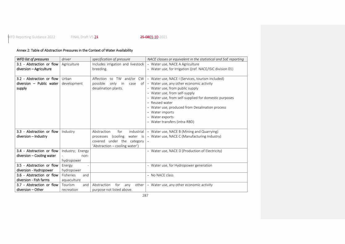
WFD Reporting Guidance 2022 FINAL Draft V5.21 25-0801-10-2021
287
Annex 2: Table of Abstraction Pressures in the Context of Water Availability
WFD list of pressures driver specification of pressure NACE classes or equivalent in the statistical and SoE reporting
3.1 - Abstraction or flow diversion – Agriculture
Agriculture Includes irrigation and livestock breeding.
- Water use, NACE A Agriculture - Water use, for Irrigation ((ref. NACE/ISIC division 01)
3.2 - Abstraction or flow diversion – Public water supply
Urban development
Affection to TW and/or CW possible only in case of desalination plants.
- Water use, NACE I (Services, tourism included) - Water use, any other economic activity - Water use, from public supply - Water use, from self-supply - Water use, from self-supplied for domestic purposes - Reused water - Water use, produced from Desalination process - Water imports - Water exports - Water transfers (intra-RBD)
3.3 - Abstraction or flow diversion – Industry
Industry Abstraction for industrial processes (cooling water is covered under the category ‘Abstraction – cooling water’)
- Water use, NACE B (Mining and Quarrying) - Water use, NACE C (Manufacturing Industry) -
3.4 - Abstraction or flow diversion – Cooling water
Industry; Energy - non-hydropower
- Water use, NACE D (Production of Electricity)
3.5 - Abstraction or flow diversion - Hydropower
Energy - hydropower
- Water use, for Hydropower generation
3.6 - Abstraction or flow diversion - Fish farms
Fisheries and aquaculture
- No NACE class
3.7 - Abstraction or flow diversion – Other
Tourism and recreation
Abstraction for any other purpose not listed above.
- Water use, any other economic activity

WFD Reporting Guidance 2022 FINAL Draft V5.21 25-0801-10-2021
288
Annex 3: Significant pressures mapped to indicators, KTMs and KTM indicators
Indicative mapping of significant pressures and chemical substances causing failure of objectives with Key Types of Measures, with quantitative indicators of the scale of the pressures to be tackled and the scale of measures planned to achieve WFD Environmental Objectives. Please note that the indicators listed may, in some cases, not have a direct correspondence in the lists of indicators in Annexes 8p and 8r. The indicators to be used should be, in each case, the most appropriate ones, selected from the ones listed in those two annexes. It should also be noted that both annexes include also the option of chosing “other” indicators if none of those listed are appropriate.
Significant pressure or chemical substance failing
Main driver(s) Indicators for pressure Relevant KTM Indicators for KTM
1.1 - Point – Urban waste water
Urban development Load of BOD to be reduced (in tonnes) to achieve objectives
1 Construction or upgrades of wastewater treatment plants
Population equivalent required to be treated by construction or upgrade of waste water treatment works
Load of nitrogen to be reduced (in tonnes) to achieve objectives
Number of wastewater treatment works requiring to be constructed or upgraded
Load of phosphorus to be reduced (in tonnes) to achieve objectives
Number of water bodies failing EQS for RBSP
Loads of priority substances to be reduced (in tonnes) to achieve objectives
15 Measures for the phasing-out of emissions, discharges and losses of priority hazardous substances or for the reduction of emissions, discharges and losses of priority substances.
Number of new permits to be issued or updated
Number of installations associated with priority substances requiring measures to achieve objectives
Number of substances requiring restrictions or bans on uses to achieve objectives

WFD Reporting Guidance 2022 FINAL Draft V5.21 25-0801-10-2021
289
Significant pressure or chemical substance failing
Main driver(s) Indicators for pressure Relevant KTM Indicators for KTM
1.2 - Point - Storm overflows
Urban development Load of BOD to be reduced (in tonnes) to achieve objectives
1 Construction or upgrades of wastewater treatment plants
Number of Combined Sewer Overflows to be upgraded to achieve objectives
Number of urban areas with excessive overflows that are causing or contributing to failure of objectives
Number of water bodies failing EQS for PS and/or RBSP
Load of sediment to be reduced to (in tonnes) to achieve WFD Environmental Objectives.
17 Measures to reduce sediment loads from soil erosion and surface run-off
Number of storm overflows where sediment flow to surface water will be intercepted or reduced.
Volume of storm water that is causing or contributing to failure of objectives
23 Natural water retention measures
Number of sustainable drainage systems required to achieve objectives
Number of urban areas with excessive overflows that are causing or contributing to failure of objectives
1.3 - Point - IED plants Industry Number of permits not compatible with the achievement of objectives
16 Upgrades or improvements of industrial wastewater treatment plants (including farms)
Number of installation where upgrades or improvements are required to achieve objectives
Number of water bodies failing EQS for RBSP
Number of revised permit required to achieve objectives

WFD Reporting Guidance 2022 FINAL Draft V5.21 25-0801-10-2021
290
Significant pressure or chemical substance failing
Main driver(s) Indicators for pressure Relevant KTM Indicators for KTM
Number of permits not compatible with the achievement of objectives
15 Measures for the phasing-out of emissions, discharges and losses of priority hazardous substances or for the reduction of emissions, discharges and losses of priority substances.
Number of water bodies failing EQS for priority substances
Number of substances requiring restrictions or bans on uses to achieve objectives
1.4 - Point - Non IED plants
Industry
Number of permits not compatible with the achievement of objectives
16 Upgrades or improvements of industrial wastewater treatment plants (including farms)
Number of revised permit required to achieve objectives
Number of water bodies failing EQS for RBSP
1.5 - Point - Contaminated sites or abandoned industrial sites
Industry Number of contaminated sites affecting the achievement of objectives
4 Remediation of contaminated sites (historical pollution including sediments, groundwater, soil).
Number of sites to be remediated or where preventative actions are to be taken to achieve objectives
Number of water bodies failing EQS for PS and/or RBSP
1.6 - Point - Waste disposal sites
Urban development Number of waste disposal sites affecting achievement of objectives
21 Measures to prevent or control the input of pollution from urban areas, transport and built infrastructure
Number of upgraded or remediated waste disposal sites required to achieve objectives
Number of water bodies failing EQS for PS and/or RBSP
Number of water bodies affected by measures

WFD Reporting Guidance 2022 FINAL Draft V5.21 25-0801-10-2021
291
Significant pressure or chemical substance failing
Main driver(s) Indicators for pressure Relevant KTM Indicators for KTM
1.7 - Point - Mine waters Industry Number of mine water discharges affecting achievement of objectives
New MS KTM Number of mine discharges for which measures are required to achieve objectives
Number of water bodies failing EQS for PS and/or RBSP
1.8 - Point - Aquaculture Fisheries and aquaculture
Number of point sources affecting achievement of objectives
New MS KTM Number of aquaculture sites/facilities for which measures are required to achieve objectives
Number of water bodies failing EQS for PS and/or RBSP
1.9 - Point – Other Number of point sources affecting achievement of objectives
New MS KTM Number of water bodies affected by measures to achieve objectives
2.1 - Diffuse - Urban run-off
Urban development, Industry
Length (km)/area (km2) of water bodies that are not achieving objectives because of diffuse urban run off
21 Measures to prevent or control the input of pollution from urban areas, transport and built infrastructure
Number of sustainable drainage systems required to achieve objectives
Number of upgraded storm overflows required to achieve objectives
Number of surface water interceptors and treatment facilities required to achieve objectives

WFD Reporting Guidance 2022 FINAL Draft V5.21 25-0801-10-2021
292
Significant pressure or chemical substance failing
Main driver(s) Indicators for pressure Relevant KTM Indicators for KTM
Area (km2) requiring regulation and/or codes of practice for use and disposal of chemicals in urbanised areas, transport and infrastructure to achieve objectives.
2.2 - Diffuse – Agricultural Agriculture Load of nitrogen to be reduced (in tonnes) to achieve objectives
2 Reduce nutrient pollution from agriculture
Area of agricultural land covered by measures (km2) to achieve objectives
Load of phosphorus to be reduced (in tonnes) to achieve objectives
Length (km)/area (km2) of buffer strips required to achieve objectives
Number of water bodies failing EQS for pesticides originating from diffuse agricultural sources
3 Reduce pesticides pollution from agriculture.
Area of agricultural land covered by measures (km2) to reduce pesticide pollution in agriculture to achieve objectives
Number of farms not covered by advisory services
12 Advisory services for agriculture
Number of farms that need to be covered by advisory services to achieve objectives
Number of advisory services required to achieve objectives
Area (km2) of agricultural land requiring measures to achieve objectives
Number of Farm Surveys required to achieve objectives.

WFD Reporting Guidance 2022 FINAL Draft V5.21 25-0801-10-2021
293
Significant pressure or chemical substance failing
Main driver(s) Indicators for pressure Relevant KTM Indicators for KTM
Number of water bodies affected by emissions, discharges or losses of priority and priority hazardous substances
15 Measures for the phasing-out of emissions, discharges and losses of priority hazardous substances or for the reduction of emissions, discharges and losses of priority substances.
Number of substances requiring restrictions or bans on uses to achieve objectives
Number, length, area of water bodies not achieving objectives because of this pressure
17 Measures to reduce sediment loads from soil erosion and surface run-off
Length of river requiring buffer zones to intercept or reduce sediment loads to rivers to achieve objectives
Area of water body bodies requiring buffer zones to intercept or reduce sediment loads to water bodies to achieve objectives
Area of agricultural land at risk of soil erosion
Area of agricultural land (km2) requiring measures to achieve objectives
2.3 - Diffuse – Forestry
Forestry
Number of water bodies not achieving objectives because of this pressure
22 Measures to prevent or control the input of pollution from forestry
Area of forestry land (km2) requiring measures to reduce nutrient inputs to levels compatible with the achievement of objectives.
Area (km2) of forest affecting the achievement of objectives
Length of river requiring buffer zones to intercept or reduce sediment loads to rivers to achieve objectives

WFD Reporting Guidance 2022 FINAL Draft V5.21 25-0801-10-2021
294
Significant pressure or chemical substance failing
Main driver(s) Indicators for pressure Relevant KTM Indicators for KTM
Area of forest land (km2) requiring measures to achieve objectives
Area of forestry land (km2) at risk of soil erosion
17 Measures to reduce sediment loads from soil erosion and surface run-off
Area of water body bodies requiring buffer zones to intercept or reduce sediment loads to water bodies to achieve objectives.
Area of forest land (km2) requiring measures to achieve objectives
2.4 - Diffuse – Transport Transport Number of water bodies not achieving objectives because of this pressure
21 Measures to prevent or control the input of pollution from urban areas, transport and built infrastructure
Number of surface water interceptors and treatment facilities required to achieve objectives.
Length of transport infrastructure required to be subject to regulation and/or codes of practice for use and disposal of chemicals for the achievement of objectives
2.5 - Diffuse – Contaminated sites or abandoned industrial sites
Industry Number of contaminated sites affecting the achievement of objectives
4 Remediation of contaminated sites (historical pollution including sediments, groundwater, soil)
Area of land covered by the measures (km2) required to achieve objectives
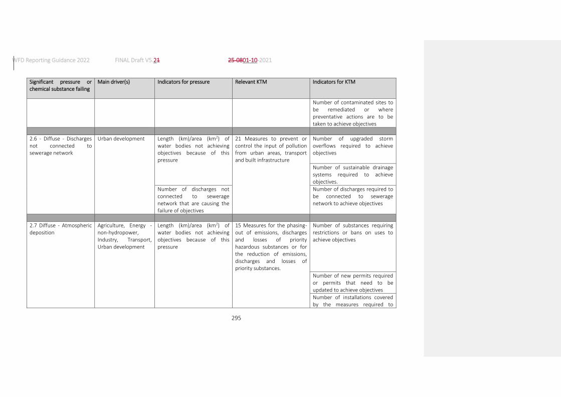
WFD Reporting Guidance 2022 FINAL Draft V5.21 25-0801-10-2021
295
Significant pressure or chemical substance failing
Main driver(s) Indicators for pressure Relevant KTM Indicators for KTM
Number of contaminated sites to be remediated or where preventative actions are to be taken to achieve objectives
2.6 - Diffuse - Discharges not connected to sewerage network
Urban development Length (km)/area (km2) of water bodies not achieving objectives because of this pressure
21 Measures to prevent or control the input of pollution from urban areas, transport and built infrastructure
Number of upgraded storm overflows required to achieve objectives
Number of sustainable drainage systems required to achieve objectives.
Number of discharges not connected to sewerage network that are causing the failure of objectives
Number of discharges required to be connected to sewerage network to achieve objectives
2.7 Diffuse - Atmospheric deposition
Agriculture, Energy - non-hydropower, Industry, Transport, Urban development
Length (km)/area (km2) of water bodies not achieving objectives because of this pressure
15 Measures for the phasing-out of emissions, discharges and losses of priority hazardous substances or for the reduction of emissions, discharges and losses of priority substances.
Number of substances requiring restrictions or bans on uses to achieve objectives
Number of new permits required or permits that need to be updated to achieve objectives
Number of installations covered by the measures required to

WFD Reporting Guidance 2022 FINAL Draft V5.21 25-0801-10-2021
296
Significant pressure or chemical substance failing
Main driver(s) Indicators for pressure Relevant KTM Indicators for KTM
achieve objectives
25 Measures to counteract acidification
Number of water bodies that need to be limed to achieve objectives
Length of buffer zones required to counteract acidification for the achievement of objectives
Number of new permits required or permits that need to be updated to achieve objectives
Number of installations that need to be covered by measures to achieve objectives
2.8 - Diffuse – Mining Industry Length (km)/area (km2) of water bodies not achieving objectives because of this pressure
New MS KTM Number of mines for which measures are required to achieve objectives.
2.9 - Diffuse – Aquaculture
Fisheries and aquaculture
Length (km)/area (km2) of water bodies not achieving objectives because of this pressure
New MS KTM Number of aquaculture sites/facilities for which measures are required to achieve objectives
2.10 - Diffuse – Other Length (km)/area (km2) of water bodies not achieving objectives because of this pressure
New MS KTM Number of water bodies affected by the measures required to achieve objectives

WFD Reporting Guidance 2022 FINAL Draft V5.21 25-0801-10-2021
297
Significant pressure or chemical substance failing
Main driver(s) Indicators for pressure Relevant KTM Indicators for KTM
3.1 - Abstraction or flow diversion – Agriculture
Agriculture Volume of water abstracted/diverted for agriculture (million m3) to be reduced to achieve objectives.
7 Improvements in flow regime and/or establishment of ecological flows.
Number of revised permit required to achieve objectives
Number of water bodies where ecological flows need to be established to achieve objectives.
8 Water efficiency technical measures for irrigation, industry, energy and households
Irrigated area required to be covered by measures to achieve objectives
Reduction (%) in water consumption required to achieve objectives
11 Progress in water pricing policy measures for the implementation of the recovery of cost of water services from agriculture
Agricultural area (km2) where water pricing policy measures are required to achieve the objectives of Article 9
12 Advisory services for agriculture
Number of farms that need to covered by advisory services to achieve objectives
Number of advisory services required to achieve objectives
Area (km2) of agricultural land that needs to be covered by advisory services to achieve objectives.

WFD Reporting Guidance 2022 FINAL Draft V5.21 25-0801-10-2021
298
Significant pressure or chemical substance failing
Main driver(s) Indicators for pressure Relevant KTM Indicators for KTM
Number of Farm Surveys required to be undertaken to achieve objectives
3.2 - Abstraction or flow diversion – Public water supply
Urban development Volume of water abstracted/diverted for public water supply (million m3) to be reduced to achieve objectives
7 Improvements in flow regime and/or establishment of ecological flows.
Number of revised permit required to achieve objectives
Number of water bodies where ecological flows need to be established to achieve objectives.
8 Water efficiency technical measures for irrigation, industry, energy and households
Number of households required to be covered by measures to achieve objectives
Reduction (%) in water consumption required to achieve objectives
9 Progress in water pricing policy measures for the implementation of the recovery of cost of water services from households
Size of population for which water pricing policy measures are required to achieve the objectives of Article 9
Area (km2) of RBD for which water pricing policy measures are required to achieve the objectives of Article 9

WFD Reporting Guidance 2022 FINAL Draft V5.21 25-0801-10-2021
299
Significant pressure or chemical substance failing
Main driver(s) Indicators for pressure Relevant KTM Indicators for KTM
3.3 - Abstraction or flow diversion – Industry
Industry Volume of water abstracted/diverted for industry (million m3) to be reduced to achieve objectives
7 Improvements in flow regime and/or establishment of ecological flows.
Number of revised permit required to achieve objectives
Number of water bodies where ecological flows need to be established to achieve objectives.
8 Water efficiency technical measures for irrigation, industry, energy and households
Number of installations required to be covered by measures to achieve objectives
Reduction (%) in water consumption required to achieve objectives
10 Progress in water pricing policy measures for the implementation of the recovery of cost of water services from industry
Number of installations for which water pricing policy measures are required to achieve the objectives of Article 9
3.4 - Abstraction or flow diversion – Cooling water
Industry, Energy - non-hydropower
Volume of water abstracted/diverted for cooling water (million m3) to be reduced to achieve objectives
7 Improvements in flow regime and/or establishment of ecological flows
Number of revised permit required to achieve objectives
Number of water bodies where ecological flows need to be established to achieve objectives.

WFD Reporting Guidance 2022 FINAL Draft V5.21 25-0801-10-2021
300
Significant pressure or chemical substance failing
Main driver(s) Indicators for pressure Relevant KTM Indicators for KTM
10 Progress in water pricing policy measures for the implementation of the recovery of cost of water services from industry
Number of installations for which water pricing policy measures are required to achieve the objectives of Article 9
3.5 - Abstraction or flow diversion – Hydropower
Energy - hydropower Volume of water abstracted/diverted (million m3) to be reduced to achieve objectives
7 Improvements in flow regime and/or establishment of ecological flows.
Number of revised permit required to achieve objectives
Number of water bodies where ecological flows need to be established to achieve objectives.
10 Progress in water pricing policy measures for the implementation of the recovery of cost of water services from industry
Number of installations for which water pricing policy measures are required to achieve the objectives of Article 9
3.6 - Abstraction or flow diversion - Fish farms
Fisheries and aquaculture
Volume of water abstracted/diverted for aquaculture (million m3) to be reduced to achieve objectives
7 Improvements in flow regime and/or establishment of ecological flows
Number of revised permit required to achieve objectives
Number of water bodies where ecological flows need to be established to achieve objectives.
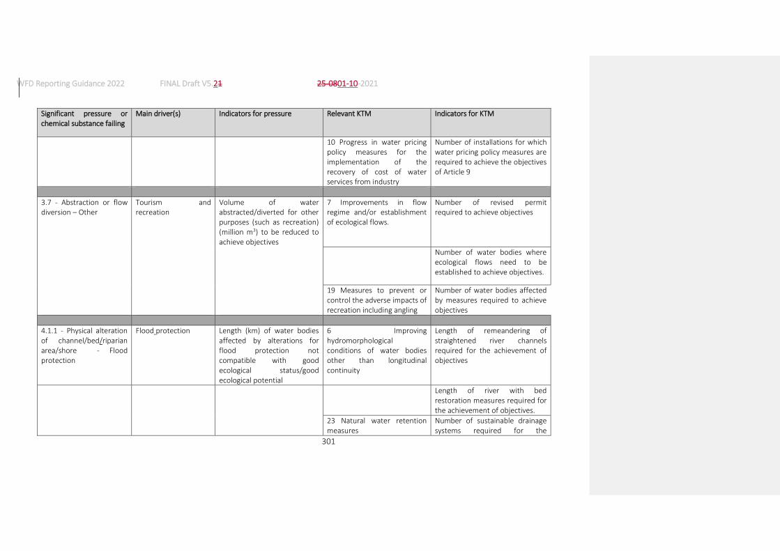
WFD Reporting Guidance 2022 FINAL Draft V5.21 25-0801-10-2021
301
Significant pressure or chemical substance failing
Main driver(s) Indicators for pressure Relevant KTM Indicators for KTM
10 Progress in water pricing policy measures for the implementation of the recovery of cost of water services from industry
Number of installations for which water pricing policy measures are required to achieve the objectives of Article 9
3.7 - Abstraction or flow diversion – Other
Tourism and recreation
Volume of water abstracted/diverted for other purposes (such as recreation) (million m3) to be reduced to achieve objectives
7 Improvements in flow regime and/or establishment of ecological flows.
Number of revised permit required to achieve objectives
Number of water bodies where ecological flows need to be established to achieve objectives.
19 Measures to prevent or control the adverse impacts of recreation including angling
Number of water bodies affected by measures required to achieve objectives
4.1.1 - Physical alteration of channel/bed/riparian area/shore - Flood protection
Flood protection Length (km) of water bodies affected by alterations for flood protection not compatible with good ecological status/good ecological potential
6 Improving hydromorphological conditions of water bodies other than longitudinal continuity
Length of remeandering of straightened river channels required for the achievement of objectives
Length of river with bed restoration measures required for the achievement of objectives.
23 Natural water retention measures
Number of sustainable drainage systems required for the
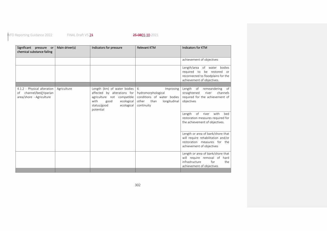
WFD Reporting Guidance 2022 FINAL Draft V5.21 25-0801-10-2021
302
Significant pressure or chemical substance failing
Main driver(s) Indicators for pressure Relevant KTM Indicators for KTM
achievement of objectives
Length/area of water bodies required to be restored or reconnected to floodplains for the achievement of objectives.
4.1.2 - Physical alteration of channel/bed/riparian area/shore - Agriculture
Agriculture Length (km) of water bodies affected by alterations for agriculture not compatible with good ecological status/good ecological potential
6 Improving hydromorphological conditions of water bodies other than longitudinal continuity
Length of remeandering of straightened river channels required for the achievement of objectives
Length of river with bed restoration measures required for the achievement of objectives.
Length or area of bank/shore that will require rehabilitation and/or restoration measures for the achievement of objectives
Length or area of bank/shore that will require removal of hard infrastructure for the achievement of objectives
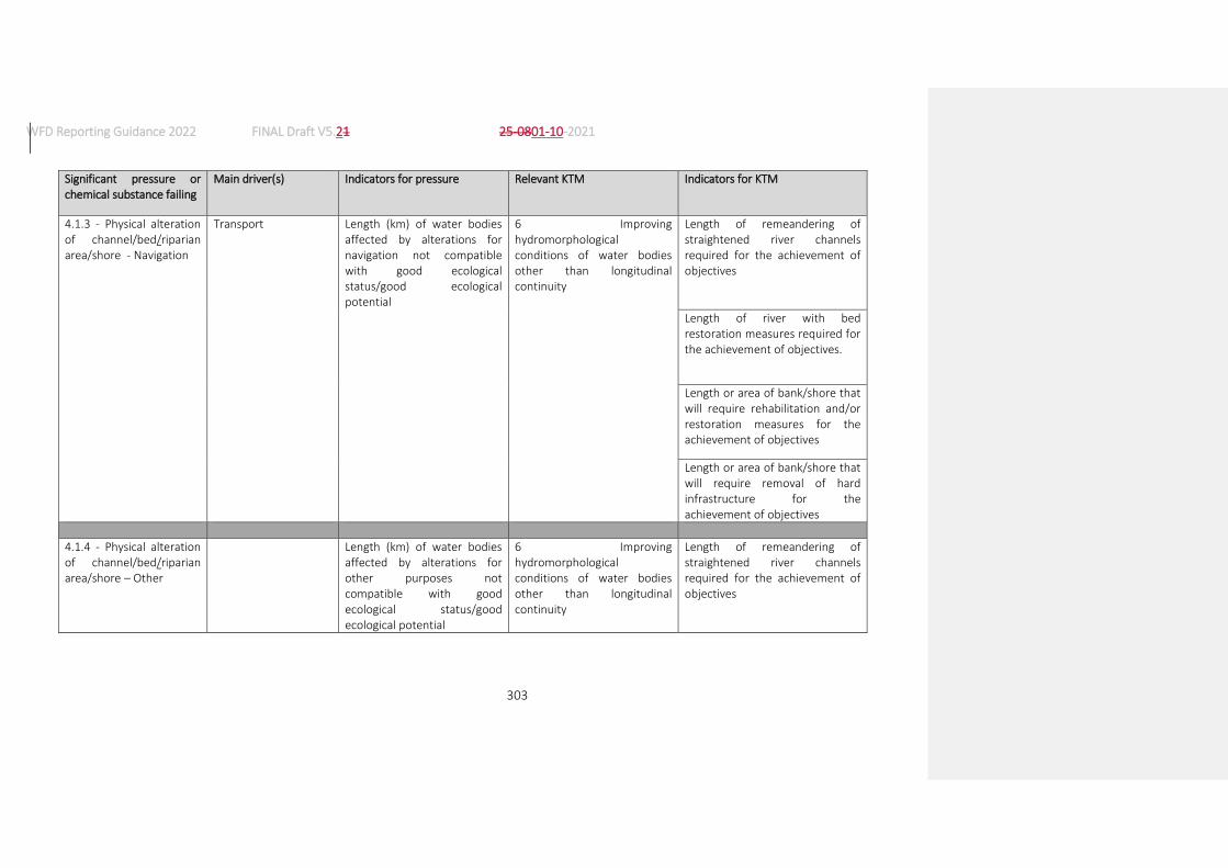
WFD Reporting Guidance 2022 FINAL Draft V5.21 25-0801-10-2021
303
Significant pressure or chemical substance failing
Main driver(s) Indicators for pressure Relevant KTM Indicators for KTM
4.1.3 - Physical alteration of channel/bed/riparian area/shore - Navigation
Transport Length (km) of water bodies affected by alterations for navigation not compatible with good ecological status/good ecological potential
6 Improving hydromorphological conditions of water bodies other than longitudinal continuity
Length of remeandering of straightened river channels required for the achievement of objectives
Length of river with bed restoration measures required for the achievement of objectives.
Length or area of bank/shore that will require rehabilitation and/or restoration measures for the achievement of objectives
Length or area of bank/shore that will require removal of hard infrastructure for the achievement of objectives
4.1.4 - Physical alteration of channel/bed/riparian area/shore – Other
Length (km) of water bodies affected by alterations for other purposes not compatible with good ecological status/good ecological potential
6 Improving hydromorphological conditions of water bodies other than longitudinal continuity
Length of remeandering of straightened river channels required for the achievement of objectives

WFD Reporting Guidance 2022 FINAL Draft V5.21 25-0801-10-2021
304
Significant pressure or chemical substance failing
Main driver(s) Indicators for pressure Relevant KTM Indicators for KTM
Length of river with bed restoration measures required for the achievement of objectives.
Length or area of bank/shore that will require rehabilitation and/or restoration measures for the achievement of objectives
Length or area of bank/shore that will require removal of hard infrastructure for the achievement of objectives
4.1.5 - Physical alteration of channel/bed/riparian area/shore – Unknown or obsolete
Length (km) of water bodies affected by alterations for unknown purposes not compatible with good ecological status/good ecological potential
6 Improving hydromorphological conditions of water bodies other than longitudinal continuity
Length of remeandering of straightened river channels required for the achievement of objectives
Length of river with bed restoration measures required for the achievement of objectives.

WFD Reporting Guidance 2022 FINAL Draft V5.21 25-0801-10-2021
305
Significant pressure or chemical substance failing
Main driver(s) Indicators for pressure Relevant KTM Indicators for KTM
Length or area of bank/shore that will require rehabilitation and/or restoration measures for the achievement of objectives
Length or area of bank/shore that will require removal of hard infrastructure for the achievement of objectives
4.2.1 - Dams, barriers and locks - Hydropower
Energy – hydropower
Number of dams, weirs, barriers and locks associated with hydropower that have conditions not compatible with the achievement of good ecological status/good ecological potential
5 Improving longitudinal continuity (e.g. establishing fish passes, demolishing old dams).
Number of barriers required to be tackled for the achievement of objectives
Length (km) or area (km2) of river network that will be affected by the measures required to achieve objectives
Number of fish/continuity passes required to be installed to achieve objectives
4.2.2 - Dams, barriers and locks - Flood protection
Flood Protection Number of dams, weirs, barriers and locks associated with flood protection that have conditions not compatible with the achievement of good ecological status/good ecological potential
5 Improving longitudinal continuity (e.g. establishing fish passes, demolishing old dams).
Number of barriers required to be tackled for the achievement of objectives

WFD Reporting Guidance 2022 FINAL Draft V5.21 25-0801-10-2021
306
Significant pressure or chemical substance failing
Main driver(s) Indicators for pressure Relevant KTM Indicators for KTM
Length (km) or area (km2) of river network that will be affected by the measures required to achieve objectives
Number of fish/continuity passes required to be installed to achieve objectives
4.2.3 - Dams, barriers and locks - Drinking water
Urban development Number of dams, weirs, barriers and locks associated with drinking water that have conditions not compatible with the achievement of good ecological status/good ecological potential
5 Improving longitudinal continuity (e.g. establishing fish passes, demolishing old dams).
Number of barriers required to be tackled for the achievement of objectives
Length (km) or area (km2) of river network that will be affected by the measures required to achieve objectives
Number of fish/continuity passes required to be installed to achieve objectives
4.2.4 - Dams, barriers and locks - Irrigation
Agriculture Number of dams, weirs, barriers and locks associated with irrigation that have conditions not compatible with the achievement of good ecological status/good
5 Improving longitudinal continuity (e.g. establishing fish passes, demolishing old dams).
Number of barriers required to be tackled for the achievement of objectives

WFD Reporting Guidance 2022 FINAL Draft V5.21 25-0801-10-2021
307
Significant pressure or chemical substance failing
Main driver(s) Indicators for pressure Relevant KTM Indicators for KTM
ecological potential
Length (km) or area (km2) of river network that will be affected by the measures required to achieve objectives
Number of fish/continuity passes required to be installed to achieve objectives.
4.2.5 - Dams, barriers and locks - Recreation
Tourism and recreation
Number of dams, weirs, barriers and locks associated with recreation that have conditions not compatible with the achievement of good ecological status/good ecological potential
5 Improving longitudinal continuity (e.g. establishing fish passes, demolishing old dams).
Number of barriers required to be tackled for the achievement of objectives
Length (km) or area (km2) of river network that will be affected by the measures required to achieve objectives
Number of fish/continuity passes required to be installed to achieve objectives.
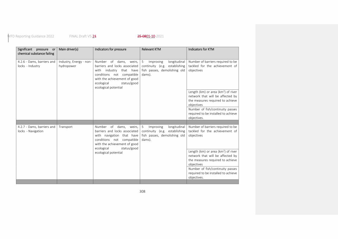
WFD Reporting Guidance 2022 FINAL Draft V5.21 25-0801-10-2021
308
Significant pressure or chemical substance failing
Main driver(s) Indicators for pressure Relevant KTM Indicators for KTM
4.2.6 - Dams, barriers and locks - Industry
Industry, Energy - non-hydropower
Number of dams, weirs, barriers and locks associated with industry that have conditions not compatible with the achievement of good ecological status/good ecological potential
5 Improving longitudinal continuity (e.g. establishing fish passes, demolishing old dams).
Number of barriers required to be tackled for the achievement of objectives
Length (km) or area (km2) of river network that will be affected by the measures required to achieve objectives
Number of fish/continuity passes required to be installed to achieve objectives.
4.2.7 - Dams, barriers and locks - Navigation
Transport
Number of dams, weirs, barriers and locks associated with navigation that have conditions not compatible with the achievement of good ecological status/good ecological potential
5 Improving longitudinal continuity (e.g. establishing fish passes, demolishing old dams).
Number of barriers required to be tackled for the achievement of objectives
Length (km) or area (km2) of river network that will be affected by the measures required to achieve objectives
Number of fish/continuity passes required to be installed to achieve objectives.

WFD Reporting Guidance 2022 FINAL Draft V5.21 25-0801-10-2021
309
Significant pressure or chemical substance failing
Main driver(s) Indicators for pressure Relevant KTM Indicators for KTM
4.2.8 - Dams, barriers and locks – Other
Number of dams, weirs, barriers and locks associated with other uses that have conditions not compatible with the achievement of good ecological status/good ecological potential
5 Improving longitudinal continuity (e.g. establishing fish passes, demolishing old dams).
Number of barriers required to be tackled for the achievement of objectives
Length (km) or area (km2) of river network that will be affected by the measures required to achieve objectives
Number of fish/continuity passes required to be installed to achieve objectives.
4.2.9 - Dams, barriers and locks – Unknown or obsolete
Number of dams, weirs, barriers and locks that have conditions not compatible with the achievement of good ecological status/good ecological potential
5 Improving longitudinal continuity (e.g. establishing fish passes, demolishing old dams).
Number of barriers required to be tackled for the achievement of objectives
Length (km) or area (km2) of river network that will be affected by the measures required to achieve objectives
Number of fish/continuity passes required to be installed to achieve objectives.

WFD Reporting Guidance 2022 FINAL Draft V5.21 25-0801-10-2021
310
Significant pressure or chemical substance failing
Main driver(s) Indicators for pressure Relevant KTM Indicators for KTM
4.3.1 - Hydrological alteration – Agriculture
Agriculture Length (km) /area (km2) of water bodies where hydrological alterations for agricultural purposes are preventing the achievement of good ecological status/good ecological potential
7 Improvements in flow regime and/or establishment of ecological flows.
Number of revised permit required to achieve objectives
Number of water bodies where ecological flows need to be established to achieve objectives.
4.3.2 - Hydrological alteration – Transport
Transport
Length (km) /area (km2) of water bodies where hydrological alterations for transport purposes are preventing the achievement of good ecological status/good ecological potential
7 Improvements in flow regime and/or establishment of ecological flows.
Length of rivers (km) affected by the measures required for the achievement of objectives.
Number of revised permit required to achieve objectives
Number of water bodies where ecological flows need to be established to achieve objectives.

WFD Reporting Guidance 2022 FINAL Draft V5.21 25-0801-10-2021
311
Significant pressure or chemical substance failing
Main driver(s) Indicators for pressure Relevant KTM Indicators for KTM
4.3.3 - Hydrological alteration – Hydropower
Energy – hydropower Length (km) /area (km2) of water bodies where hydrological alterations for hydropower production are preventing the achievement of good ecological status/good ecological potential
7 Improvements in flow regime and/or establishment of ecological flows.
Number of water bodies where the operational modification of hydro-peaking is required for the achievement of objectives.
Number of revised permit required to achieve objectives
Number of water bodies where ecological flows need to be established to achieve objectives.
4.3.4 - Hydrological alteration – Public water supply
Urban development Length (km) /area (km2) of water bodies where hydrological alterations for public water supply purposes are preventing the achievement of good ecological status/good ecological potential
7 Improvements in flow regime and/or establishment of ecological flows.
Number of revised permit required to achieve objectives
Number of water bodies where ecological flows need to be established to achieve objectives.
4.3.5 - Hydrological alteration - Aquaculture
Fisheries and aquaculture
Length (km) /area (km2) of water bodies where
7 Improvements in flow regime and/or establishment
Number of revised permit required to achieve objectives

WFD Reporting Guidance 2022 FINAL Draft V5.21 25-0801-10-2021
312
Significant pressure or chemical substance failing
Main driver(s) Indicators for pressure Relevant KTM Indicators for KTM
hydrological alterations for aquaculture purposes are preventing the achievement of good ecological status/good ecological potential
of ecological flows.
Number of water bodies where ecological flows need to be established to achieve objectives.
4.3.6 - Hydrological alteration – other
Length (km) /area (km2) of water bodies where hydrological alterations for other purposes are preventing the achievement of good ecological status/good ecological potential
7 Improvements in flow regime and/or establishment of ecological flows.
Number of revised permit required to achieve objectives
Number of water bodies where ecological flows need to be established to achieve objectives.
4.4 – Hydromorphological alteration - Physical loss of whole or part of the water body
Flood Protection, Climate change
Length (km) /area (km2) of water bodies where physical loss of habitats are preventing the achievement of good ecological status/good ecological potential
New MS KTM Length/area of water bodies that are required to be restored or reconnected to floodplains for the achievement of objectives.
Length/area of water bodies that require to be restored to achieve objectives
Number of water bodies affected by the measures required to achieve objectives

WFD Reporting Guidance 2022 FINAL Draft V5.21 25-0801-10-2021
313
Significant pressure or chemical substance failing
Main driver(s) Indicators for pressure Relevant KTM Indicators for KTM
Length/area of water bodies affected by the measures required to achieve objectives
4.5 - Hydromorphological alteration - Other
Length (km)/area (km2) of water bodies where other hydromorphological alterations are preventing the achievement of good ecological status/good ecological potential
New MS KTM Length/area of water bodies affected by the measures required to achieve objectives
5.1 - Introduced species and diseases
Transport, Fisheries and aquaculture, Tourism and recreation
Number of introduced species preventing the achievement of GES/GEP
18 Measures to prevent or control the adverse impacts of invasive alien species and introduced diseases
Number of species for which codes of practice for reducing the spread of invasive alien species are required to be developed and implemented for the achievement of objectives.
Number of water bodies required to have eradication or control measures for the achievement of objectives
Number of Individual Species Action Plans required for species identified as presenting particular risk levels for the achievement of objectives

WFD Reporting Guidance 2022 FINAL Draft V5.21 25-0801-10-2021
314
Significant pressure or chemical substance failing
Main driver(s) Indicators for pressure Relevant KTM Indicators for KTM
Number of introduced diseases preventing the achievement of GES/GEP
Number of water bodies required to have eradication or control measures for the achievement of objectives
5.2 - Exploitation or removal of animals or plants
Recreation, Fisheries and aquaculture
Length (km) /area (km2) of water bodies where the exploitation/removal of animal/plants is preventing the achievement of good ecological status/good ecological potential
20 Measures to prevent or control the adverse impacts of fishing and other exploitation/removal of animal and plants
Number of water bodies affected by the measures required to achieve objectives
Length/area of water bodies affected by the measures required to achieve objectives
5.3 – Litter or fly tipping Urban development, Transport
Length (km) of water bodies impacted by litter or fly tipping
New MS KTM Length of water bodies where litter is required to be removed to achieve objectives
Number of sources of litter that require control measures to achieve objectives
6.1 - Groundwater - recharges
Agriculture, Energy – non-hydropower, Industry, Urban development
Area of groundwater bodies not achieving objectives because of groundwater recharges
New MS KTM Area of water bodies affected by the measures required to achieve objectives

WFD Reporting Guidance 2022 FINAL Draft V5.21 25-0801-10-2021
315
Significant pressure or chemical substance failing
Main driver(s) Indicators for pressure Relevant KTM Indicators for KTM
6.2 - Groundwater – Alteration of water level or volume
Industry, Urban development
Area of groundwater bodies not achieving objectives because of alteration of water levels/volumes
New MS KTM Area of water bodies affected by the measures required to achieve objectives
7 - Anthropogenic pressure - Other
Length (km) /area (km2) of water bodies where other anthropogenic pressures are causing the non achievement of objectives
New MS KTM Length/area of water bodies affected by the measures required to achieve objectives
8 – Anthropogenic pressure -Unknown
Length (km) /area (km2) of water bodies where unknown pressures are causing the non achievement of objectives
New MS KTM Length/area of water bodies affected by the measures required to achieve objectives
A number of pressure may be applicable - MS to select those relevant
Any driver See list of potential indicators for the selected relevant pressures
13 Drinking water protection measures (e.g. establishment of safeguard zones, buffer zones etc)
Number of drinking water protection zones required to achieve objectives
Number of water bodies that are required to be affected by drinking water protection measures for the achievement of objectives
Any pressure may be applicable - MS to select those relevant
Any driver See list of potential indicators for the selected relevant pressures
14 Research, improvement of knowledge base reducing uncertainty.
Number of the research studies etc. that are required to achieve objectives.

WFD Reporting Guidance 2022 FINAL Draft V5.21 25-0801-10-2021
316
Significant pressure or chemical substance failing
Main driver(s) Indicators for pressure Relevant KTM Indicators for KTM
Number of water bodies that are expected to achieve objectives as a result of research etc.
Failure of good chemical status by a Priority Substance
Agriculture, urban development, industry, transport
Loads of priority substances that require to be reduced (in tonnes) to achieve objectives.
15 Measures for the phasing-out of emissions, discharges and losses of priority hazardous substances or for the reduction of emissions, discharges and losses of priority substances.
Number of revised permit required to achieve objectives
Number of installation where upgrades or improvements are required to achieve objectives
Number of substances requiring restrictions or bans on uses to achieve objectives
Number of water bodies failing EQS for priority substances
3 Reduce pesticides pollution from agriculture.
Area of agricultural land required to be covered by measures to achieve objectives
Length (km)/area (km2) of buffer strips required to achieve objectives.
4 Remediation of contaminated sites (historical pollution including sediments, groundwater, soil).
Area (km2) of land required to be covered by measures to achieve objectives.
Number of sites requiring measures to achieve objectives
13 Drinking water protection measures (e.g. establishment of safeguard zones, buffer zones etc)
Number of drinking water protection zones required to achieve objectives

WFD Reporting Guidance 2022 FINAL Draft V5.21 25-0801-10-2021
317
Significant pressure or chemical substance failing
Main driver(s) Indicators for pressure Relevant KTM Indicators for KTM
Area of land required to be covered by drinking water protection zones to achieve objectives
16 Upgrades or improvements of industrial wastewater treatment plants (including farms)
Number of installation where upgrades or improvements are required to achieve objectives.
Number of new permits required, or require to be updated, to achieve objectives.
21 Measures to prevent or control the input of pollution from urban areas, transport and built infrastructure
Number of sustainable drainage systems required to achieve objectives
Number of upgraded storm overflows required to achieve objectives
Number of pesticides and other chemicals requiring restrictions or bans on uses to achieve objectives
Number of surface water interceptors and treatment systems required to achieve objectives.

WFD Reporting Guidance 2022 FINAL Draft V5.21 25-0801-10-2021
318
Significant pressure or chemical substance failing
Main driver(s) Indicators for pressure Relevant KTM Indicators for KTM
Failure of good ecological status by a River Basin Specific Pollutant
Agriculture, urban development, industry, transport, forestry, aquaculture, energy
Loads of river basin specific pollutants that require to be reduced (in tonnes) to achieve objectives
3 Reduce pesticides pollution from agriculture.
Area of agricultural land required to be covered by measures to achieve objectives
Number of water bodies failing EQS for RBSP
Length (km)/area (km2) of buffer strips required to achieve objectives.
4 Remediation of contaminated sites (historical pollution including sediments, groundwater, soil).
Area (km2) of land required to covered by measures to achieve objectives.
Number of sites requiring measures to achieve objectives
13 Drinking water protection measures (e.g. establishment of safeguard zones, buffer zones etc)
Number of drinking water protection zones required to achieve objectives
Area of land required to be covered by drinking water protection zones to achieve objectives
16 Upgrades or improvements of industrial wastewater treatment plants (including farms)
Number of installation where upgrades or improvements are required to achieve objectives
Number of new permits required, or require to be updated, to achieve objectives.

WFD Reporting Guidance 2022 FINAL Draft V5.21 25-0801-10-2021
319
Significant pressure or chemical substance failing
Main driver(s) Indicators for pressure Relevant KTM Indicators for KTM
21 Measures to prevent or control the input of pollution from urban areas, transport and built infrastructure
Number of sustainable drainage systems required to achieve objectives.
Number of upgraded storm overflows required to achieve objectives.
Number of pesticides and other chemicals requiring restrictions or bans on uses to achieve objectives
Number of surface water interceptors and treatment systems required to achieve objectives.
22 Measures to prevent or control the input of pollution from forestry
Area of forested land (km2) required to be covered by measures to achieve objectives.
Length (km)/area (km2) of buffer strips required to achieve objectives.

320
Annex 4: Groundwater bodies and horizon assignment
1. GROUNDWATER BODIES AND HORIZON ASSIGNMENT
1.1. Horizon assignment - Purpose of horizons
Groundwater bodies (GWBs) are three-dimensional entities. However, their representation will be as 2-D polygons, as the Commission and the EEA do not have a systematic model that would allow at this stage comparable 3D visualisation. Borders of polygons of GWBs are their projection on the surface. It is necessary that multiple overlapping groundwater bodies at different depths with non-identical boundaries are distinguished in different horizons (layers) (EU, 2009). The characterisation of the vertical position of GWBs by ‘horizons’ should:
help to reflect the three-dimensionality of GWBs and their vertical (relative) position to other
GWBs.
enable the stratified visualization of GWBs on maps and
help to identify and visualise those (parts of) GWBs which are probably most exposed to
anthropogenic pressures on the surface – the uppermost horizon, the outcrops (e.g. for
geological maps).
2. RECOMMENDATIONS FOR HORIZON ASSIGNMENT – TO ENABLE HOMOGENEOUS MAPPING AT A PAN-EUROPEAN SCALE
Within this chapter, an approach for horizon assignment is proposed. This approach is illustrated by an example of GWB arrangements
2.1. Proposal for horizon assignment
The methodology considers the following features:
The assignment of horizons follows a simple numeration in the sense of the numerical
position of the groundwater body starting with the first GWB-horizon from the surface (EU,
2009)
Groundwater bodies can be split into sub-units for the purpose of assigning these sub-units
individually to corresponding horizons, depending on the overlap with other GWBs;
There is no limitation in the number of horizons;
Overlaying groundwater bodies cannot be associated to the same horizon.
Horizon Code Brief description
1 (Part of) first GWB from the surface
2 (Part of) second GWB from the surface
3 (Part of) third GWB from the surface
…etc…. …etc….

321
It has to be emphasized that the assignment of GWBs to horizons should not be mixed with (is separate from) the delineation of GWBs which is strictly subject to Member State’s decisions and methods. Horizon assignment is just a tool to enable harmonised and coherent visualisation of GWBs at the European level and to support transboundary coordination. It is therefore solely a matter of reporting.
Except for the uppermost horizon (horizon 1) the assignment of a (part of a) GWB to a certain horizon does not give any information about its absolute vertical position within the overall schema, just the relative position to overlying or underlying (parts of) GWBs from the surface.
2.2. Reporting of GIS information to WISE
It is proposed to report GIS information with the following architecture:
Reporting groundwater bodies using the GroundWaterBody data set
The horizons attribute identifies the different horizons present in the water body, to be reported as integer values.
Reporting horizons using the GroundWaterBodyHorizon data set
Attribute name Obligation Type Description
thematicIdIdentifier Required FeatureUniqueEUCodeType euGroundWaterBodyCode of the Ground Water Body as defined in the GroundWaterBody reporting schema.
Code MUST have a 1-to-1 relationship with euGroundWaterBodyCode and further attribute data described in the related XML file.
thematicIdIdentifierScheme Required CharacterString Identifier defining the scheme used to assign the identifier.
horizon Required integer Numeration in the sense of the numerical position of groundwater body layer starting at the first GWB-horizon from the surface (as proposed in the table above). Multiplicity 0...99
2.3. Example – Groundwater bodies
The proposed procedure is illustrated by an example of delineated GWBs.

322
It is important to consider, that the following example is not intended to stipulate any discussion about the presented delineation and configuration of GWBs. The only purpose is to demonstrate the ability of the proposed procedure to cover types of GWB arrangements.
Map view Sectional view
Horizon assignment – Map view
Horizon 1 Horizon 2 Horizon 3
Horizon assignment – Vertical subsequential arrangement
Proposal for GIS layers reporting:
Reporting groundwater bodies using the GroundWaterBody data set
thematicIdentifier horizons
GWB1 1
GWB2 2
GWB3 1,2,3

323
and GroundWaterBodyHorizon data set
thematicIdentifier thematicIdentifierScheme horizon
GWB3 euGroundWaterBodyCode 1
GWB3 euGroundWaterBodyCode 2
GWB3 euGroundWaterBodyCode 3

324
For the production of respective GIS layers, the following procedure is proposed:
3

325
2.4. Sources of information
Duscher, K., Struckmeier, W. (2011) – A common vision about groundwater entities in Europe, Presentation at the 2nd Workshop on Groundwater bodies held in Berlin 15th-16th December 2011.
ETC/ICM (2013) – Groundwater GIS reference layer. Submission/compilation status and evaluation. Version 3.
European Commission (2003) – Guidance Document No 2: Identification of Water Bodies. ISBN 92-894-5122-X. European Communities, Luxembourg.
European Commission (2009) – Guidance on reporting of spatial data for the WFD (RBMP). Tools and services for reporting under RBMP within WISE. Version 3.0. .
European Commission (2010) – Guidance Document No. 26. Guidance on Risk Assessment and the use of conceptual models for groundwater.
UK Technical Advisory Group on the Water Framework Directive (2012) – Defining & Reporting on Groundwater Bodies. Final version.
Ward, R. (2011) – 2nd Workshop on Groundwater Bodies held in Berlin 15/16 December 2011, Presentation at the 22nd Working Group C plenary meeting held in Brussels the 21st March 2012.

326
Annex 5: Guidance for reporting spatial data
The Guidance for reporting spatial data is available as a separate document.

327
Annex 6: Reporting on the River Basin Management Plans – a user manual
Reporting on the River Basin Management Plans will be done, as was the case in the past, through Reportnet. A detailed users’ manual for Reportnet is available as a separate document.

328
Annex 7: Reporting guidance on inventories
The CIS Technical Guidance Document no. 28, “Technical Guidance on the Preparation of an Inventory of Emissions, Discharges and Losses of Priority and Priority Hazardous Substances131” (TGD 28), sets out the steps to help Member States establish their inventories. The purpose of this annex is to relate SoE-WISE categories to the sources and pathways set out in that guidance. This is intended to allow the collection of comparable data which may then be used in assessment of sources, trends and review of policy measures.
As set out in Section 9.3 of this reporting guidance, different source and/or pathway categorisation schemes exist. Of particular relevance here are: the source or pathway categories in TGD 28; the WISE SoE emissions source categories, http://dd.eionet.europa.eu/datasets/latest/Emissions ; the WFD list of pressure types in Annex 1a of this reporting guidance. Efforts to harmonise these categories has taken place, with the alignment of WISE SoE source categories with WFD pressures and the most recent WISE SoE Emission reportings being based on the updated source category code list.
Section III.1 of TGD 28 describes the general working scheme of the inventory of emissions. Sources, pathways and riverine loads to surface waters are considered. To reduce the risk of differing interpretations as to where data should be recorded, the information in tables [2i] and [2ii] below is provided to assist Member States in their submission of inventory data.
For the 3rd RBMPs, the following notes are intended to facilitate voluntary reporting of pollutant inputs according to one of the above categorisations.
Table 1 illustrates approximate correspondence between the source and pathway categories in TGD28, SoE source categories and WFD list of pressures. See also Figure 5 in Section 9.3 of the WFD Reporting Guidance 2016.
Table 1: Relationships between the source and pathway categories in the CIS Inventory Guidance, the SoE source categories and the WFD list of pressures
Inventory Guidance source Inventory Guidance pathway
SoE emissions code WFD pressure type (source code)
Air Emissions P1: Atmospheric Deposition directly to Surface Waters
NP2132 2.7
Agriculture, Air Emissions P2: Erosion Can be a component in NP1, NP2, NP7, NP8 and NP71
Source-dependent
Agriculture, Air Emissions P3: Surface Runoff from Unsealed Areas
Can be a component in NP1, NP2, NP7, NP8 and NP71
2.2, 2.3, 2.4, 2.7, 2.10
131 https://circabc.europa.eu/sd/a/6a3fb5a0-4dec-4fde-a69d-5ac93dfbbadd/Guidance%20document%20n28.pdf 132 This WISE SoE source category includes atmospheric deposition for diffuse source on the whole surface of RBD or
sub-unit (not only direct deposition to water surfaces).

329
Inventory Guidance source Inventory Guidance pathway
SoE emissions code WFD pressure type (source code)
Agriculture, Households, Air Emissions
P4 Interflow, Tile Drainage and Groundwater
Can be a component in NP1, NP 2, NP7, NP8 and NP71
Source-dependent
Agriculture P5: Direct Discharges and Drifting
NP1 2.2
Air Emissions, Transportation and Infrastructure, Construction Material
P6: Surface Runoff from Sealed Areas
Can be a component in NP 2, NP7 and NP72
2.1, 2.4
Air Emissions, Transportation and Infrastructure, Construction Material, Households, Industry
P7: Storm Water Outlets, Combined Sewer Overflows and Unconnected Sewers
U1+ NP5 1.2
Air Emissions, Transportation and Infrastructure, Construction Material, Households, Industry
P8: Urban Waste Water Treated
U2 1.1
Households P9: Individual - Treated and Untreated - Household Discharges
NP3 2.6
Industry P10 Industrial Waste Water treated
(and untreated)
I3+ I4 1.3, 1.4
Abandoned and Historic Mines P11: Direct Discharges from Mining Areas
O 1.7, 2.8
Inland Navigation P12: Direct Discharges from Navigation
NP7 2.4
Natural Background P13 Natural Background NP8 Not applicable
Tables 2i and 2ii show how to correlate between the WFD list of pressure types list and SoE emissions source categories.
Table 2i: Relationship between the WFD list of pressure types to WISE SoE emissions source categories
WFD pressure type WISE SoE emissions source
1 – Point source of pollution PT – Point sources Note that the proper correspondence is PT plus NP5.
1.1 – Point - Urban waste water U – Point - Urban waste water Further disaggregation is possible in the WISE SoE Emissions data flow.
1.2 – Point - Storm overflows NP5 – Diffuse - Storm overflow emissions Note that in the WISE SoE Emissions data flow, this source is reported as a diffuse sources.
1.3 – Point - IED plants I – Point - Industrial waste water Further disaggregation is possible in the WISE SoE Emissions data flow.

330
WFD pressure type WISE SoE emissions source
1.4 – Point - Non IED plants I – Point - Industrial waste water Further disaggregation is possible in the WISE SoE Emissions data flow.
1.5 – Point - Contaminated sites or abandoned industrial sites
O1 – Point - Contaminated sites or abandoned industrial sites Note that under WISE SoE Emissions, these emissions can be included in the "O – Point - Other" value if the data is not disaggregated by subcategory.
1.6 – Point - Waste disposal sites
O2 – Point - Waste disposal sites Note that under WISE SoE Emissions, these emissions can be included in the "O – Point - Other" value if the data is not disaggregated by subcategory.
1.7 – Point - Mine waters
O3 – Point - Mine waters Note that under WISE SoE Emissions, these emissions can be included in the "O – Point - Other" value if the data is not disaggregated by subcategory.
1.8 – Point - Aquaculture
O4 – Point - Aquaculture Note that under WISE SoE Emissions, these emissions can be included in the "O – Point - Other" value if the data is not disaggregated by subcategory.
1.9 – Point - Other
O – Point - Other Note that further disaggregation is possible under the WISE SoE Emissions data flow. A direct matching to WFD 1.9 only exist if subcategories O1, O2, O3 and O4 are reported, and if only the remainder sources are reported under the generic category "O – Point - Other".
2 – Diffuse source of pollution NP – Diffuse sources Partial correspondence. Note that WFD 2.5 is included under point sources in the WISE SoE Emissions.
2.1 – Diffuse - Urban run-off NP4 – Diffuse - Urban run-off
2.2 – Diffuse - Agricultural NP1 – Diffuse - Agricultural emissions
2.3 – Diffuse - Forestry NP71 – Diffuse - Forestry emissions
2.4 – Diffuse - Transport NP72 – Diffuse - Transport emissions
2.5 – Diffuse - Contaminated sites or abandoned industrial sites
No direct correspondence with WISE SoE Emissions sources. This type of emissions are reported under "O1 – Point - Contaminated sites or abandoned industrial sites" (or, if disaggregated values are not available, under "O – Point - Other").
2.6 – Diffuse - Discharges not connected to sewerage network
NP3 – Diffuse - Un-connected dwellings emissions
2.8 – Diffuse - Mining NP73 – Diffuse - Mining emissions
2.7 – Diffuse - Atmospheric deposition NP2 – Diffuse - Atmospheric deposition
2.9 – Diffuse - Aquaculture NP74 – Diffuse - Aquaculture emissions
2.10 – Diffuse - Other NP7 – Diffuse - Other diffuse emissions Partial correspondence: NP7-(NP71+NP72+NP73+NP74)+NP8
No correspondence NP8 – Diffuse - Background emissions
Table 2ii: Relationship between WISE SoE emissions source categories to WFD pressures
WISE SoE emissions source WFD pressure type
PT – Point sources 1 – Point source of pollution Note that "1.2 – Point - Storm overflows" are reported as diffuse sources under WISE SoE Emissions.
U – Point - Urban waste water 1.1 – Point - Urban waste water
U1 – Point - Urban waste water - untreated No direct correspondence to this WISE SoE subcategory.
U11 – Point - Urban waste water - untreated - less than 2000 p.e. No direct correspondence to this WISE SoE subcategory.
U12 – Point - Urban waste water - untreated - between 2000 and 10000 p.e.
No direct correspondence to this WISE SoE subcategory.

331
WISE SoE emissions source WFD pressure type
U13 – Point - Urban waste water - untreated - between 10000 and 100000 p.e.
No direct correspondence to this WISE SoE subcategory.
U14 – Point - Urban waste water - untreated - more than 100000 p.e. No direct correspondence to this WISE SoE subcategory.
U2 – Point - Urban waste water - treated No direct correspondence to this WISE SoE subcategory.
U21 – Point - Urban waste water - treated - less than 2000 p.e. No direct correspondence to this WISE SoE subcategory.
U22 – Point - Urban waste water - treated - between 2000 and 10000 p.e.
No direct correspondence to this WISE SoE subcategory.
U23 – Point - Urban waste water - treated - between 10000 and 100000 p.e.
No direct correspondence to this WISE SoE subcategory.
U24 – Point - Urban waste water - treated - more than 100000 p.e. No direct correspondence to this WISE SoE subcategory.
I – Point - Industrial waste water Sum of: 1.3 – Point - IED plants 1.4 – Point - Non IED plants
I3 – Point - Industrial waste water - treated No direct correspondence to this WISE SoE subcategory.
I4 – Point - Industrial waste water - untreated No direct correspondence to this WISE SoE subcategory.
O – Point - Other
1.9 – Point - Other Note that further disaggregation is possible under the WISE SoE Emissions data flow. A direct matching to WFD 1.9 only exist if subcategories O1, O2, O3 and O4 are reported, and if only the remainder sources are reported under the generic category "O – Point - Other".
O1 – Point - Contaminated sites or abandoned industrial sites
Sum of: 1.5 – Point - Contaminated sites or abandoned industrial sites 2.5 – Diffuse - Contaminated sites or abandoned industrial sites
O2 – Point - Waste disposal sites 1.6 – Point - Waste disposal sites
O3 – Point - Mine waters 1.7 – Point - Mine waters
O4 – Point - Aquaculture 1.8 – Point - Aquaculture
NP – Diffuse sources 2 – Diffuse source of pollution Partial correspondence. Note that WFD 2.5 is included under point sources in the WISE SoE Emissions.
NP1 – Diffuse - Agricultural emissions 2.2 – Diffuse - Agricultural
NP2 – Diffuse - Atmospheric deposition 2.7 – Diffuse - Atmospheric deposition
NP3 – Diffuse - Un-connected dwellings emissions 2.6 – Diffuse - Discharges not connected to sewerage network
NP4 – Diffuse - Urban run-off 2.1 – Diffuse - Urban run-off
NP5 – Diffuse - Storm overflow emissions 1.2 – Point - Storm overflows
NP7 – Diffuse - Other diffuse emissions 2.10 – Diffuse - Other Partial correspondence: NP7-(NP71+NP72+NP73+NP74)+NP8
NP71 – Diffuse - Forestry emissions 2.3 – Diffuse - Forestry
NP72 – Diffuse - Transport emissions 2.4 – Diffuse - Transport
NP73 – Diffuse - Mining emissions 2.8 – Diffuse - Mining
NP74 – Diffuse - Aquaculture emissions 2.9 – Diffuse - Aquaculture
NP8 – Diffuse - Background emissions No direct correspondence.

332
Annex 8: Enumeration Lists
Annex 8a: List of common intercalibration types (SWIntercalibrationType_Enum)
Code Description
CW-BC1 Baltic Sea, surface water salinity 0.5-6 psu, bottom water salinity 1-6 psu, Exposed, 90-150 ice days
CW-BC2 Baltic Sea, surface water salinity 6-22 psu, bottom water salinity 2-6 psu, Very sheltered
CW-BC3 Baltic Sea, surface water salinity 3-6 psu, bottom water salinity 3-6 psu, Sheltered, 90-150 ice days
CW-BC4 Baltic Sea, surface water salinity 5-8 psu, bottom water salinity 5-8 psu, Exposed, < 90 ice days
CW-BC5 Baltic Sea, surface water salinity 6-8 psu, bottom water salinity 6-12 psu, Exposed, <90 ice days
CW-BC6 Baltic Sea, surface water salinity 8-12 psu, bottom water salinity 8-12 psu, Sheltered, <90 ice days
CW-BC7 Baltic Sea, surface water salinity 6-8 psu, bottom water salinity 8-11 psu, Exposed, <90 ice days
CW-BC8 Baltic Sea, surface water salinity 13-18 psu, bottom water salinity 18-23 psu, Sheltered,<90 ice days
CW-BC9 Baltic Sea, surface water salinity 3-6 psu, bottom water salinity 3-6 psu, Moderately Exposed to exposed, 90-150 ice days
CW-BL1 Black Sea, mesohaline, microtidal, shallow, moderately exposed, mixed substratum
CW-NEA10 Skagerrak Outer Arc Type, polyhaline, microtidal, exposed, deep
CW-NEA1/26 North East Atlantic, open oceanic or enclosed seas, exposed or sheltered, euhaline, shallow (< 30 m), microtidal or mesotidal, fully mixed or partly stratified
CW-NEA1/26A2 Open oceanic, exposed or sheltered, euhaline, shallow, Temperate waters (mainly > 13°C) and high irradiance (mainly PAR > 29Mol/m2 day)
CW-NEA1/26B21 Open oceanic or enclosed seas, exposed or sheltered, euhaline, shallow cool waters (mainly < 13°C) and medium irradiance (mainly PAR < 29Mol/m2 day)
CW-NEA1/26a Open oceanic, exposed or sheltered, euhaline, shallow
CW-NEA1/26b Enclosed seas, exposed or sheltered, euhaline, shallow
CW-NEA1/26c Enclosed seas, enclosed or sheltered, partly stratified
CW-NEA1/26d Scandinavian coast, exposed or sheltered, shallow
CW-NEA1/26e Areas of upwelling, exposed or sheltered, euhaline, shallow
CW-NEA3/4 North East Atlantic, polyhaline, exposed or moderately exposed (Wadden Sea type)
CW-NEA5 Helgoland (German Bight), rocky, exposed and partly, stratified
CW-NEA7 North East, Atlantic Sea, deep fjordic and sea loch systems
CW-NEA8a North East Atlantic, Skagerrak Inner Arc Type, polyhaline (25-30), microtidal, moderately exposed, shallow, fully mixed
CW-NEA8b North East Atlantic, Skagerrak Inner Arc Type, polyhaline (10-30), microtidal, moderately sheltered, shallow, partly stratified
CW-NEA9 North East Atlantic, fjord with a shallow sill at the mouth with very deep maximum depth in the central basin with poor deepwater exchange
CW-Type_I Mediterranean, highly influenced by freshwater input
CW-Type_IIA Mediterranean, moderately influenced by freshwater input (continent influence)
CW-Type_IIA_Adriatic Mediterranean, moderately influenced by freshwater input (continent influence), Adriatic coast
CW-Type_IIIE Mediterranean, not influenced by freshwater input (Eastern Basin)
CW-Type_IIIW Mediterranean, continental coast, not influenced by freshwater input (Western Basin)
CW-Type_Island-W Mediterranean, island coast (Western Basin)
LW-EC1 Eastern Continental, lowland, very shallow, hard-water
LW-L-AL3 Alpine, lowland or mid-altitude, deep, moderate to high alkalinity (alpine influence), large
LW-L-AL4 Alpine, mid-altitude, shallow, moderate to high alkalinity (alpine influence), large
LW-L-CB1 Central Baltic, lowland, shallow, calcareous
LW-L-CB2 Central Baltic, lowland, very shallow, calcareous
LW-L-CB3 Central Baltic, lowland, shallow, small, siliceous (moderate alkalinity)

333
Code Description
LW-L-CB4 Central Baltic, Heavily modified water bodies
LW-L-M5/7 Mediterranean, reservoirs, deep, large, siliceous, “wet” areas
LW-L-M8 Mediterranean, reservoirs, deep, large, calcareous
LW-L-N1 Northern, lowland, shallow, moderate alkalinity, clear
LW-L-N2a Northern, lowland, shallow, low alkalinity, clear
LW-L-N2b Northern, lowland, deep, low alkalinity, clear
LW-L-N3a Northern, lowland, shallow, low alkalinity, meso-humic
LW-L-N3b Northern, lowland, shallow, low alkalinity, polyhumic
LW-L-N5 Northern, mid-altitude, shallow, low alkalinity, clear
LW-L-N6a Northern, mid-altitude, shallow, low alkalinity, meso-humic
LW-L-N6b Northern, mid-altitude, shallow, low alkalinity, poly-humic
LW-L-N7 Northern, highland, shallow, siliceous, low alkalinity
LW-L-N8a Northern, lowland, shallow, moderate alkalinity, meso-humic
LW-L-N8b Northern, lowland, shallow, moderate alkalinity,poli-humic
LW-L-N-BF1 Northern lowland/mid-altitude, low alkalinity, clear
LW-L-N-BF2 Northern ecoregion 22, low alkalinity, clear and humic
LW-L-N-F1 Northern dimictic clear water lakes, low alkalinity
LW-L-N-F2 Northern dimictic (meso)humic water lakes, low alkalinity
LW-L-N-M 101 Northern low alkalinity, clear
LW-L-N-M 102 Northern low alkalinity, humic
LW-L-N-M 201 Northern moderate alkalinity, clear
LW-L-N-M 202 Northern moderate alkalinity, humic
LW-L-N-M 301a Northern, high alkalinity, clear, atlantic subtype
LW-L-N-M 302a Northern, high alkalinity, humic, atlantic subtype
LW-L-HA Alpine, Central-Baltic, Eastern Continental,Mediterranean, High alkalinity lakes
LW-L-MA Alpine, Central-Baltic, Eastern Continental,Mediterranean, Northern, Moderate alkalinity lakes
LW-L-LA Northern, Low alkalinity lakes
RW-R-A1 Pre-alpine, small to medium, high altitude calcareous
RW-R-A2 Alpine, small to medium, high altitude, siliceous
RW-R-C1 Central/Baltic, small, lowland, siliceous sand
RW-R-C2 Central/Baltic, small, lowland, siliceous rock
RW-R-C3 Central/Baltic, small, mid-altitude, siliceous
RW-R-C4 Central/Baltic, medium, lowland, mixed
RW-R-C5 Central/Baltic, large, lowland, mixed
RW-R-C6 Central/Baltic, small, lowland, calcareous
RW-R-E1 Eastern Continental Carpathians, small to medium, mid-altitude (includes RW-R-E1a and RW-R-1b)
RW-R-E2 Eastern Continental Plains, medium-sized, lowland
RW-R-E3 Eastern Continental Plains, large, lowland
RW-R-E4 Eastern Continental Plains, medium-sized, mid-altitude
RW-R-EX4 Eastern Continental Large, mid-atitude
RW-R-EX5 Eastern Continental Plains, small, lowland
RW-R-EX6 Eastern Continental Plains, small, mid-altitude
RW-R-EX7 Eastern Continental Balkan, small, calcareous, mid-altitude
RW-R-EX8 Eastern Continental Balkan, small to medium-sized, calcareous karst spring

334
Code Description
RW-R-L1 Very large low alkalinity (all GIGs)
RW-R-L2 Very large medium to high alkalinity (all GIGs)
RW-R-M1 Mediterranean, small, mid-altitude
RW-R-M2 Mediterranean, medium, lowland
RW-R-M3 Mediterranean, large, lowland
RW-R-M4 Mediterranean, small-medium, Mediterranean mountains
RW-R-M5 Mediterranean, small, Mediterranean temporary
RW-R-N1 Northern, small, lowland, siliceous, moderate alkalinity
RW-R-N2 Northern, small-medium, lowland, siliceous, low alkalinity, clear
RW-R-N3 Northern, small-medium, lowland, organic, low alkalinity
RW-R-N4 Northern, medium, lowland, siliceous, moderate alkalinity
RW-R-N5 Northern, small, mid-altitude, siliceous, low alkalinity
RW-R-N7 Northern, small, highland, siliceous, low alkalinity, clear
RW-R-N9 Northern, small, medium, mid-altitude, siliceous, low alkalinity, organic (humic)
TW- BT1 Baltic Sea, surface water salinity 0-8 psu, bottom water salinity 0-8 psu, very sheltered, no ice days
TW-CoastalLagoonsMesohaline
Mediterranean Sea, coastal lagoons, salinity 5-18 psu
TW-CoastalLagoonsOligohaline
Mediterranean Sea, coastal lagoons, salinity 0-5 psu
TW-CoastalLagoonsPolyeuhaline
Mediterranean Sea, coastal lagoons, Salinity 18-40 psu
TW-Hyperhalines Mediterranean Sea, Hyperhalines (Salinity > 40 psu)
TW-Estuaries Mediterranean Sea, estuaries, salt wedge type
TW-NEA11 North East Atlantic, transitional waters
Not applicable

335
Annex 8b: List of River Basin Specific Pollutants (RBSP_Enum)
CAS Number (where relevant) or EEA (SoE) code and name provided
Pollutant
CAS_10028-17-8 - Tritium
CAS_100-41-4 - Ethylbenzene
CAS_100-42-5 - Styrene
CAS_1007-28-9 - Desisopropylatrazine
CAS_1014-69-3 - Desmetryn
CAS_101-55-3 - 4-bromophenyl phenyl ether
CAS_1024-57-3 - Heptachlor epoxide
CAS_10265-92-6 - Methamidophos
CAS_103-65-1 - n-propylbenzene
CAS_104-35-8 - 4-nonylphenol mono-ethoxylate (NP1EO)
CAS_104-51-8 - n-butylbenzene
CAS_105-67-9 - 2,4-dimethyl-phenol
CAS_10605-21-7 - Carbendazim
CAS_106-42-3 - P-xylene
CAS_106-43-4 - 4-chlorotoluene
CAS_106-44-5 - 4-methyl-phenol
CAS_106-46-7 - 1,4-dichlorobenzene
CAS_1066-51-9 - Aminomethylphosphonic acid (AMPA)
CAS_106-93-4 - 1,2-dibromoethane
CAS_1070-78-6 - 1,1,1,3-tetrachloropropane
CAS_107-13-1 - Acrylonitrile
CAS_1071-83-6 - Glyphosate
CAS_107-46-0 - Hexamethyldisiloxane (HMDS)
CAS_108-38-3 - M-xylene
CAS_108-67-8 - 1,3,5-trimethylbenzene
CAS_108-70-3 - 1,3,5-trichlorobenzene
CAS_108-86-1 - Bromobenzene
CAS_108-88-3 - Toluene
CAS_108-90-7 - Chlorobenzene
CAS_108-95-2 - Phenol
CAS_1113-02-6 - Omethoate
CAS_112410-23-8 - Tebufenozide
CAS_1163-19-5 - Bis(pentabromophenyl) ether
CAS_118-96-7 - 2,4,6-trinitrotoluene
CAS_1194-65-6 - Dichlobenil
CAS_120-36-5 - Dichlorprop (2,4-DP)
CAS_120-82-1 - 1,2,4-trichlorobenzene
CAS_120-83-2 - 2,4-dichlorophenol
CAS_120928-09-8 - Fenazaquin
CAS_121-14-2 - 2,4-dinitrotoluene
CAS_121-75-5 - Malathion
CAS_122-14-5 - Fenitrothion
CAS_1231244-60-2 - Metazachlor OA
CAS_123-33-1 - Maleinhydrazid

336
Pollutant
CAS_124-48-1 - Dibromochlorometane
CAS_12767-79-2 - Aroclor
CAS_129-00-0 - Pyrene
CAS_13071-79-9 - Terbufos
CAS_131-11-3 - Dimethyl phthalate
CAS_131-16-8 - Dipropyl phthalate
CAS_131-18-0 - Dipentyl phthalate
CAS_1321-64-8 - Pentachloronaphthalene
CAS_1321-65-9 - Trichloronaphthalene
CAS_1330-20-7 - Xylene
CAS_133-06-2 - Captan
CAS_13351-73-0 - Tolyltriazole
CAS_13356-08-6 - Fenbutatin oxide
CAS_1335-87-1 - Hexachloronaphthalene
CAS_1335-88-2 - Tetrachloronaphthalene
CAS_1336-36-3 - Polychlorinated biphenyls
CAS_133855-98-8 - Epoxiconazole
CAS_134-62-3 - Diethyltoluamide (DEET)
CAS_135-19-3 - 2-naphthol
CAS_135-98-8 - sec-butylbenzene
CAS_136426-54-5 - Fluquinconazole
CAS_136677-10-6 - Polychlorinated dibenzofurans (10 PCDFs)
CAS_13684-56-5 - Desmedipham
CAS_136-85-6 - Methylbenzotriazol
CAS_137-26-8 - Thiram
CAS_137-30-4 - Ziram
CAS_139-13-9 - NTA
CAS_139-40-2 - Propazine
CAS_140-57-8 - Aramite
CAS_142-28-9 - 1,3-dichloropropane
CAS_142363-53-9 - Alachlor ESA
CAS_14265-44-2 - Phosphate
CAS_143-50-0 - Chlordecone (Kepone)
CAS_144-49-0 - Fluoroacetic acid
CAS_14797-65-0 - Nitrite
CAS_14798-03-9 - Ammonium
CAS_151-21-3 - Sodium dodecyl sulfate
CAS_15165-67-0 - Dichlorprop-P
CAS_152019-73-3 - Metolachlor OA
CAS_15307-86-5 - Diclofenac
CAS_15541-45-4 - Bromate
CAS_15545-48-9 - Chlortoluron
CAS_1563-66-2 - Carbofuran
CAS_156-59-2 - Cis-1,2-dichloroethene
CAS_15687-27-1 - Ibuprofen
CAS_1570-64-5 - 4-chloro-2-methylphenol
CAS_1570-65-6 - 4,6-dichloro-2-methylphenol
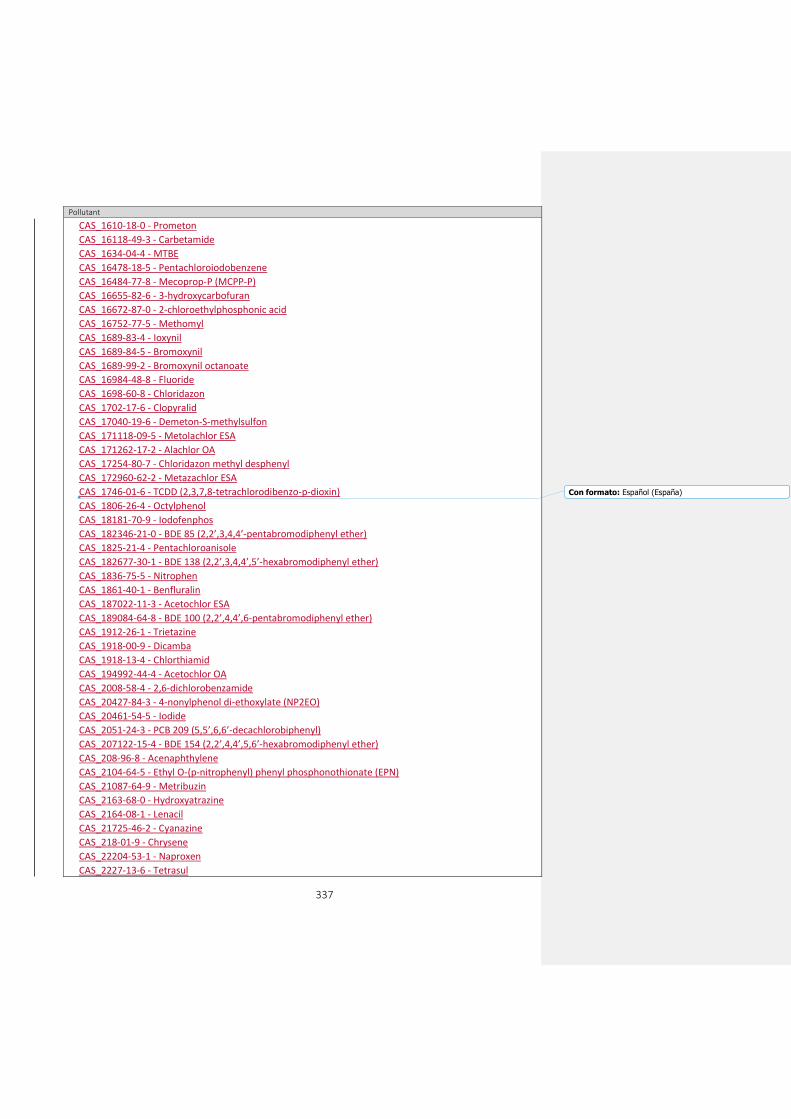
337
Pollutant
CAS_1610-18-0 - Prometon
CAS_16118-49-3 - Carbetamide
CAS_1634-04-4 - MTBE
CAS_16478-18-5 - Pentachloroiodobenzene
CAS_16484-77-8 - Mecoprop-P (MCPP-P)
CAS_16655-82-6 - 3-hydroxycarbofuran
CAS_16672-87-0 - 2-chloroethylphosphonic acid
CAS_16752-77-5 - Methomyl
CAS_1689-83-4 - Ioxynil
CAS_1689-84-5 - Bromoxynil
CAS_1689-99-2 - Bromoxynil octanoate
CAS_16984-48-8 - Fluoride
CAS_1698-60-8 - Chloridazon
CAS_1702-17-6 - Clopyralid
CAS_17040-19-6 - Demeton-S-methylsulfon
CAS_171118-09-5 - Metolachlor ESA
CAS_171262-17-2 - Alachlor OA
CAS_17254-80-7 - Chloridazon methyl desphenyl
CAS_172960-62-2 - Metazachlor ESA
CAS_1746-01-6 - TCDD (2,3,7,8-tetrachlorodibenzo-p-dioxin)
CAS_1806-26-4 - Octylphenol
CAS_18181-70-9 - Iodofenphos
CAS_182346-21-0 - BDE 85 (2,2’,3,4,4’-pentabromodiphenyl ether)
CAS_1825-21-4 - Pentachloroanisole
CAS_182677-30-1 - BDE 138 (2,2’,3,4,4’,5’-hexabromodiphenyl ether)
CAS_1836-75-5 - Nitrophen
CAS_1861-40-1 - Benfluralin
CAS_187022-11-3 - Acetochlor ESA
CAS_189084-64-8 - BDE 100 (2,2’,4,4’,6-pentabromodiphenyl ether)
CAS_1912-26-1 - Trietazine
CAS_1918-00-9 - Dicamba
CAS_1918-13-4 - Chlorthiamid
CAS_194992-44-4 - Acetochlor OA
CAS_2008-58-4 - 2,6-dichlorobenzamide
CAS_20427-84-3 - 4-nonylphenol di-ethoxylate (NP2EO)
CAS_20461-54-5 - Iodide
CAS_2051-24-3 - PCB 209 (5,5’,6,6’-decachlorobiphenyl)
CAS_207122-15-4 - BDE 154 (2,2’,4,4’,5,6’-hexabromodiphenyl ether)
CAS_208-96-8 - Acenaphthylene
CAS_2104-64-5 - Ethyl O-(p-nitrophenyl) phenyl phosphonothionate (EPN)
CAS_21087-64-9 - Metribuzin
CAS_2163-68-0 - Hydroxyatrazine
CAS_2164-08-1 - Lenacil
CAS_21725-46-2 - Cyanazine
CAS_218-01-9 - Chrysene
CAS_22204-53-1 - Naproxen
CAS_2227-13-6 - Tetrasul
Con formato: Español (España)
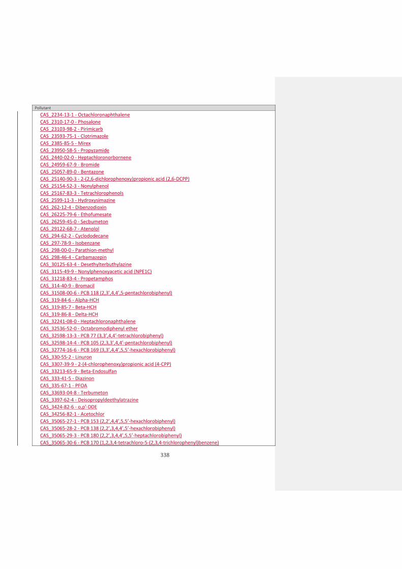
338
Pollutant
CAS_2234-13-1 - Octachloronaphthalene
CAS_2310-17-0 - Phosalone
CAS_23103-98-2 - Pirimicarb
CAS_23593-75-1 - Clotrimazole
CAS_2385-85-5 - Mirex
CAS_23950-58-5 - Propyzamide
CAS_2440-02-0 - Heptachloronorbornene
CAS_24959-67-9 - Bromide
CAS_25057-89-0 - Bentazone
CAS_25140-90-3 - 2-(2,6-dichlorophenoxy)propionic acid (2,6-DCPP)
CAS_25154-52-3 - Nonylphenol
CAS_25167-83-3 - Tetrachlorophenols
CAS_2599-11-3 - Hydroxysimazine
CAS_262-12-4 - Dibenzodioxin
CAS_26225-79-6 - Ethofumesate
CAS_26259-45-0 - Secbumeton
CAS_29122-68-7 - Atenolol
CAS_294-62-2 - Cyclododecane
CAS_297-78-9 - Isobenzane
CAS_298-00-0 - Parathion-methyl
CAS_298-46-4 - Carbamazepin
CAS_30125-63-4 - Desethylterbuthylazine
CAS_3115-49-9 - Nonylphenoxyacetic acid (NPE1C)
CAS_31218-83-4 - Propetamphos
CAS_314-40-9 - Bromacil
CAS_31508-00-6 - PCB 118 (2,3’,4,4’,5-pentachlorobiphenyl)
CAS_319-84-6 - Alpha-HCH
CAS_319-85-7 - Beta-HCH
CAS_319-86-8 - Delta-HCH
CAS_32241-08-0 - Heptachloronaphthalene
CAS_32536-52-0 - Octabromodiphenyl ether
CAS_32598-13-3 - PCB 77 (3,3’,4,4’-tetrachlorobiphenyl)
CAS_32598-14-4 - PCB 105 (2,3,3’,4,4’-pentachlorobiphenyl)
CAS_32774-16-6 - PCB 169 (3,3’,4,4’,5,5’-hexachlorobiphenyl)
CAS_330-55-2 - Linuron
CAS_3307-39-9 - 2-(4-chlorophenoxy)propionic acid (4-CPP)
CAS_33213-65-9 - Beta-Endosulfan
CAS_333-41-5 - Diazinon
CAS_335-67-1 - PFOA
CAS_33693-04-8 - Terbumeton
CAS_3397-62-4 - Deisopropyldeethylatrazine
CAS_3424-82-6 - o,p'-DDE
CAS_34256-82-1 - Acetochlor
CAS_35065-27-1 - PCB 153 (2,2’,4,4’,5,5’-hexachlorobiphenyl)
CAS_35065-28-2 - PCB 138 (2,2’,3,4,4’,5’-hexachlorobiphenyl)
CAS_35065-29-3 - PCB 180 (2,2’,3,4,4’,5,5’-heptachlorobiphenyl)
CAS_35065-30-6 - PCB 170 (1,2,3,4-tetrachloro-5-(2,3,4-trichlorophenyl)benzene)

339
Pollutant
CAS_35693-99-3 - PCB 52 (2,2’,5,5’-tetrachlorobiphenyl)
CAS_35694-08-7 - PCB 194 (1,2,3,4-tetrachloro-5-(2,3,4,5-tetrachlorophenyl)benzene)
CAS_36065-30-2 - 2,4,6-tribromophenyl 2-methyl-2,3-dibromopropy ether
CAS_36355-01-8 - Hexabromobiphenyl
CAS_37350-58-6 - Metoprolol
CAS_37680-73-2 - PCB 101 (2,2’,4,5,5’-pentachlorobiphenyl)
CAS_38380-08-4 - PCB 156 (2,3,3’,4,4’,5-hexachlorobiphenyl)
CAS_39635-31-9 - PCB 189 (1,2,3,4-tetrachloro-5-(3,4,5-trichlorophenyl)benzene)
CAS_39765-80-5 - trans-Nonachlor
CAS_40487-42-1 - Pendimethalin
CAS_41318-75-6 - BDE 28 (2,4,4'-tribromodiphenyl ether)
CAS_41394-05-2 - Metamitron
CAS_41859-67-0 - Bezafibrate
CAS_4234-79-1 - Kelevan
CAS_4636-83-3 - Morfamquat
CAS_4901-51-3 - 2,3,4,5-tetrachlorophenol
CAS_4904-61-4 - 1,5,9-cyclododecatriene
CAS_50-00-0 - Formaldehyde
CAS_50-30-6 - 2,6-dichlorobenzoic acid
CAS_50563-36-5 - Dimethachlor
CAS_51000-52-3 - Vinyl neodecanoate
CAS_512-04-9 - Diosgenin
CAS_51218-45-2 - Metolachlor
CAS_51235-04-2 - Hexazinone
CAS_52236-30-3 - Desamino-diketo-metribuzin
CAS_52645-53-1 - Permethrin-cis+trans
CAS_52663-72-6 - PCB 167 (1,2,3-trichloro-5-(2,4,5-trichlorophenyl)benzene)
CAS_526-75-0 - 2,3-dimethyl-phenol
CAS_53-19-0 - o,p'-DDD
CAS_534-52-1 - Dinitro-o-cresol (DNOC)
CAS_53-70-3 - Dibenzo(a,h)anthracene
CAS_540-59-0 - 1,2-dichloroethene
CAS_541-73-1 - 1,3-dichlorobenzene
CAS_5436-43-1 - BDE 47 (2,2’,4,4’-tetrabromodiphenyl ether)
CAS_55512-33-9 - Pyridate
CAS_55525-54-7 - 3,3’-(ureylenedimethylene)bis(3,5,5’- trimethylcyclohexyl) diisocyanate
CAS_5598-13-0 - Chlorpyrifos-methyl
CAS_563-58-6 - 1,1-dichloropropene
CAS_56-38-2 - Parathion
CAS_56507-37-0 - Diketo-metribuzin
CAS_57465-28-8 - PCB 126 (3,3’,4,4’,5-pentachlorobiphenyl)
CAS_576-26-1 - 2,6-dimethyl-phenol
CAS_57-63-6 - 17alpha-ethinylestradiol (EE2)
CAS_57-74-9 - Chlordane
CAS_57837-19-1 - Metalaxyl
CAS_58-08-2 - Caffeine
CAS_58-89-9 - Gamma-HCH (Lindane)
Con formato: Español (España)
Con formato: Español (España)

340
Pollutant
CAS_58-90-2 - 2,3,4,6-tetrachlorophenol
CAS_5915-41-3 - Terbuthylazine
CAS_594-20-7 - 2,2-dichloropropane
CAS_59473-04-0 - AOX
CAS_59-50-7 - 3-methyl-4-chlorophenol
CAS_60-00-4 - EDTA
CAS_60145-21-3 - PCB 103 (2,2',4,5',6-pentachlorobiphenyl)
CAS_60207-90-1 - Propiconazole
CAS_60348-60-9 - BDE 99 (2,2’,4,4’,5-pentabromodiphenyl ether)
CAS_603-35-0 - Triphenyl phosphine
CAS_60-51-5 - Dimethoate
CAS_6108-10-7 - Epsilon-HCH
CAS_6164-98-3 - Chlordimeform
CAS_6190-65-4 - Desethylatrazine
CAS_630-20-6 - 1,1,1,2-tetrachloroethane
CAS_6339-19-1 - Chloridazon desphenyl
CAS_64743-03-9 - Phenols
CAS_64902-72-3 - Chlorsulfuron
CAS_65510-44-3 - PCB 123 (1,2,3-trichloro-5-(2,4-dichlorophenyl)benzene)
CAS_66753-07-9 - Hydroxyterbuthylazine
CAS_67129-08-2 - Metazachlor
CAS_67564-91-4 - Fenpropimorph
CAS_68631-49-2 - BDE 153 (2,2’,4,4’,5,5’-hexabromodiphenyl ether)
CAS_688-73-3 - Tributyltin compounds
CAS_69782-90-7 - PCB 157 (2,3,3’,4,4’,5’-hexachlorobiphenyl)
CAS_7012-37-5 - PCB 28 (2,4,4’-trichlorobiphenyl)
CAS_70124-77-5 - Flucythrinate
CAS_70362-41-3 - PCB 106 (2,3,3',4,5'-pentachlorobiphenyl)
CAS_70362-50-4 - PCB 81 (3,4,4',5-tetrachlorobiphenyl)
CAS_70630-17-0 - Metalaxyl-M
CAS_70776-03-3 - Naphthalene, chloro derivatives
CAS_7085-19-0 - Mecoprop
CAS_71-55-6 - 1,1,1-trichloroethane
CAS_723-46-6 - Sulfamethoxazol
CAS_72-43-5 - Methoxychlor
CAS_72-54-8 - p,p'-DDD
CAS_72-55-9 - p,p'-DDE
CAS_7286-69-3 - Sebuthylazine
CAS_7287-19-6 - Prometryn
CAS_732-26-3 - 2,4,6-tri-tert-butylphenol
CAS_738-70-5 - Trimethoprim
CAS_74223-64-6 - Metsulfuronmethyl
CAS_7429-90-5 - Aluminium and its compounds
CAS_7439-89-6 - Iron and its compounds
CAS_7439-93-2 - Lithium
CAS_7439-95-4 - Magnesium
CAS_7439-96-5 - Manganese and its compounds

341
Pollutant
CAS_7439-98-7 - Molybdenum and its compounds
CAS_7440-09-7 - Potassium
CAS_7440-22-4 - Silver
CAS_7440-23-5 - Sodium
CAS_7440-24-6 - Strontium
CAS_7440-28-0 - Thallium
CAS_7440-31-5 - Tin and its compounds
CAS_7440-32-6 - Titanium
CAS_7440-33-7 - Tungsten and its compounds
CAS_7440-36-0 - Antimony
CAS_7440-38-2 - Arsenic and its compounds
CAS_7440-39-3 - Barium
CAS_7440-41-7 - Beryllium
CAS_7440-42-8 - Boron
CAS_7440-47-3 - Chromium and its compounds
CAS_7440-48-4 - Cobalt and its compounds
CAS_7440-50-8 - Copper and its compounds
CAS_7440-61-1 - Uranium
CAS_7440-62-2 - Vanadium and its compounds
CAS_7440-66-6 - Zinc and its compounds
CAS_7440-70-2 - Calcium
CAS_74472-37-0 - PCB 114 (2,3,4,4',5-pentachlorobiphenyl)
CAS_74-83-9 - Bromomethane
CAS_74-90-8 - Hydrogen cyanide
CAS_74-95-3 - Dibromomethane
CAS_74-97-5 - Bromochloromethane
CAS_75-01-4 - Chloroethene (vinylchloride)
CAS_75-25-2 - Bromoform
CAS_75-34-3 - 1,1-dichloroethane
CAS_75-35-4 - 1,1-dichloroethene
CAS_75-69-4 - Trichlorofluoromethane
CAS_75-71-8 - Dichlorodifluoromethane
CAS_75-99-0 - Dalapon
CAS_76-03-9 - Trichloroacetic acid
CAS_76-44-8 - Heptachlor
CAS_77-47-4 - Hexachlorocyclopentadiene (HCCP)
CAS_7782-41-4 - Fluorine
CAS_7782-49-2 - Selenium and its compounds
CAS_7783-06-4 - Hydrogen sulphide
CAS_78-87-5 - 1,2-dichloropropane
CAS_789-02-6 - DDT, o,p'
CAS_79-00-5 - 1,1,2-trichloroethane
CAS_793-24-8 - 4-(dimethylbutylamino) diphenylamin (6PPD)
CAS_79-34-5 - 1,1,2,2-tetrachloroethane
CAS_79-94-7 - Tetrabromobisphenol A (TBBP-A)
CAS_8001-35-2 - Toxaphene
CAS_80-05-7 - Bisphenol A
Con formato: Español (España)

342
Pollutant
CAS_81103-11-9 - Clarithromycin
CAS_81-15-2 - Musk xylene
CAS_82-68-8 - Quintozene
CAS_83-32-9 - Acenaphthene
CAS_834-12-8 - Ametryn
CAS_83905-01-5 - Azitromycin
CAS_84-66-2 - Di-ethyl phthalate
CAS_84-69-5 - Di-iso-butyl phthalate
CAS_84-74-2 - Dibutylphthalate
CAS_84852-15-3 - 4-nonylphenol, branched
CAS_85-01-8 - Phenanthrene
CAS_85-22-3 - Pentabromoethylbenzene
CAS_85-68-7 - Butyl benzyl phthalate (BBP)
CAS_86-73-7 - Fluorene
CAS_87-61-6 - 1,2,3-trichlorobenzene
CAS_87-65-0 - 2,6-dichlorophenol
CAS_88-06-2 - 2,4,6-trichlorophenol
CAS_88-85-7 - Dinoseb
CAS_90-12-0 - 1-methylnaphthalene
CAS_91-57-6 - 2-methylnaphthalene
CAS_919-86-8 - Demeton-S-methyl
CAS_93-72-1 - Fenoprop
CAS_93-76-5 - 2,4,5-T
CAS_94-74-6 - MCPA
CAS_94-75-7 - 2,4-dichlorophenoxyacetic acid, 2-4 D
CAS_94-81-5 - MCPB
CAS_94-82-6 - 2,4-DB
CAS_95-14-7 - Benzotriazol
CAS_95-47-6 - O-xylene
CAS_95-48-7 - 2-methyl-phenol
CAS_95-49-8 - 2-chlorotoluene
CAS_95-50-1 - 1,2-dichlorobenzene
CAS_95-63-6 - 1,2,4-trimethylbenzene
CAS_95-65-8 - 3,4-dimethyl-phenol
CAS_95-87-4 - 2,5-dimethylphenol
CAS_95-95-4 - 2,4,5-trichlorophenol
CAS_959-98-8 - Alpha-Endosulfan
CAS_96-12-8 - 1,2-dibromo-3-chloropropane
CAS_96-18-4 - 1,2,3-trichloropropane
CAS_96-45-7 - Ethylenethiourea (ETU)
CAS_98-06-6 - tert-butylbenzene
CAS_98-51-1 - 4-tert-butyltoluene
CAS_98-82-8 - Isopropylbenzene
CAS_994-05-8 - TAME
CAS_99-87-6 - 4-isopropyltoluene
EEA_00-00-0 - Other parameter
EEA_33-01-2 - Alkalised benzene

343
Pollutant
EEA_33-02-3 - Benzol
EEA_33-04-5 - Brominated flame retardants
EEA_33-05-6 - BTEX
EEA_33-06-7 - Chlorinated benzene
EEA_33-07-8 - Chlorinated phenol
EEA_33-09-0 - Detergents
EEA_33-10-3 - Dichlorobenzene
EEA_33-11-4 - Dichlorophenol
EEA_33-13-6 - DOX
EEA_33-14-7 - Extractable organically bound chlorine
EEA_33-15-8 - Halogenated organic compounds
EEA_33-17-0 - Hydrocarbons
EEA_33-18-1 - Meta xylene + para xylene
EEA_33-19-2 - Mono basic phenols
EEA_33-20-5 - Monochlorophenols
EEA_33-21-6 - Nitrobenzene
EEA_33-22-7 - Oil fractions (C10-40)
EEA_33-23-8 - Petroleum hydrocarbons
EEA_33-24-9 - Petroleum products
EEA_33-26-1 - Polychlorinated dibenzodioxins (PCDD)
EEA_33-27-2 - Radionuclides
EEA_33-28-3 - Surfactants (anionic and nonionic)
EEA_33-29-4 - Surfactants (anionic)
EEA_33-31-8 - Total chrysene + triphenylene
EEA_33-32-9 - Total DDD (DDD, o,p' + DDD, p,p')
EEA_33-36-3 - Total hydrocarbons
EEA_33-38-5 - Polychlorinated biphenyls (7 PCB: 28,52,101,118,138,153,180)
EEA_33-40-9 - Total dioxins and furans (PCDD + PCDF)
EEA_33-41-0 - Total tri-, tetra- and pentachlorophenol
EEA_33-42-1 - Total trichloroethylene + tetrachloroethylene
EEA_33-43-2 - Total trihalomethanes
EEA_33-44-3 - Total highly volatile halogenated hydrocarbons
EEA_33-45-4 - Volatile halogenated hydrocarbons (VHH)
EEA_33-46-5 - Volatile organic halogens (VOX)
CAS_1002-53-5 - Dibutyltin
CAS_100-00-5 - 1-chloro-4-nitrobenzene
CAS_100-02-7 - Nitrophenol
CAS_100-44-7 - Benzyl chloride
CAS_10061-01-5 - cis-1,3-dichloropropene
CAS_10061-02-6 - trans-1,3-dichloropropene
CAS_100646-51-3 - Quizalofop-P-ethyl
CAS_101205-02-1 - Cycloxydim
CAS_101-21-3 - Chlorpropham
CAS_101-42-8 - Fenuron
CAS_1031-07-8 - Endosulfan sulfate
CAS_104206-82-8 - Mesotrione
CAS_104-40-5 - 4-nonylphenol
Con formato: Español (España)
Con formato: Español (España)

344
Pollutant
CAS_105827-78-9 - Imidacloprid (Watch list only alternative code)
CAS_10599-90-3 - Chloramide
CAS_106-47-8 - 4-chloroaniline
CAS_106-48-9 - 4-chlorophenol
CAS_106700-29-2 - Pethoxamid
CAS_106-89-8 - Epichlorohydrin
CAS_107-05-1 - 3-chloropropene
CAS_107-07-3 - 2-Chloroethanol
CAS_107534-96-3 - Tebuconazole
CAS_108-41-8 - 3-chlorotoluene
CAS_108-42-9 - 3-chloroaniline
CAS_108-43-0 - 3-chlorophenol
CAS_108-60-1 - Bis(2-chloro-1-methylethyl) ether
CAS_108-62-3 - Metaldehyde
CAS_108-68-9 - 3,5-dimethyl-phenol
CAS_109-89-7 - Diethylamine
CAS_110488-70-5 - Dimethomorph
CAS_111991-09-4 - Nicosulfuron
CAS_113096-99-4 - Cyproconazole
CAS_114-26-1 - Propoxur
CAS_116-06-3 - Aldicarb
CAS_116-29-0 - Teradifon
CAS_118134-30-8 - Spiroxamine
CAS_120923-37-7 - Amidosulfuron
CAS_121552-61-2 - Cyprodinil
CAS_121-73-3 - 1-chloro-3-nitrobenzene
CAS_121776-33-8 - Furilazole
CAS_121-86-8 - 2-chloro-4-nitrotoluene
CAS_122-39-4 - Diphenylamine
CAS_122-88-3 - 4-Chlorophenoxyacetic acid (CPA 4)
CAS_122931-48-0 - Rimsulfuron
CAS_123-91-1 - 1,4-dioxane
CAS_124-40-3 - Dimethylamine
CAS_126535-15-7 - Triflusulfuron-methyl
CAS_126-73-8 - Tributyl phosphate
CAS_126-75-0 - Demeton-S
CAS_126833-17-8 - Fenhexamid
CAS_126-99-8 - 2-Chloro-1,3-butadiene
CAS_131341-86-1 - Fludioxonil
CAS_131860-33-8 - Azoxystrobin
CAS_13194-48-4 - Ethoprophos
CAS_133-07-3 - Folpet
CAS_1332-21-4 - Asbestos
CAS_1333-82-0 - Chromium trioxide (CrO3)
CAS_133-53-9 - 2,4-dichloro-3,5-dimethylphenol
CAS_13360-45-7 - Chlorbromuron
CAS_134098-61-6 - Fenpyroximate
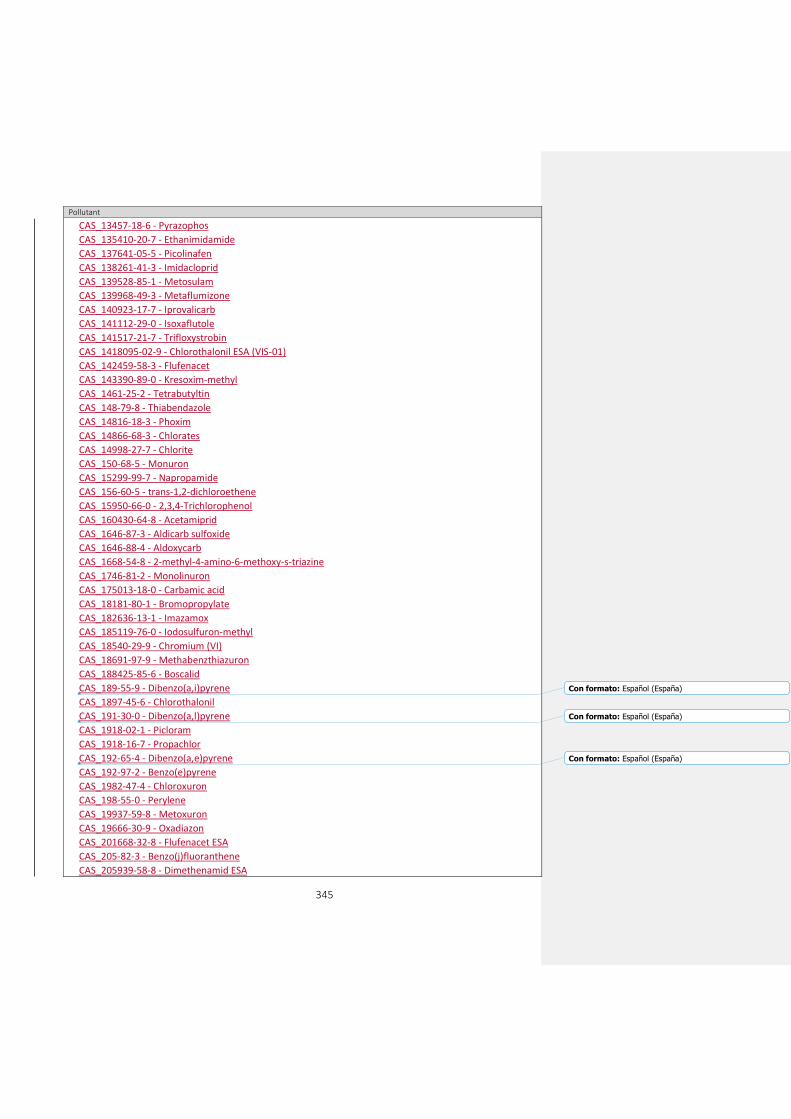
345
Pollutant
CAS_13457-18-6 - Pyrazophos
CAS_135410-20-7 - Ethanimidamide
CAS_137641-05-5 - Picolinafen
CAS_138261-41-3 - Imidacloprid
CAS_139528-85-1 - Metosulam
CAS_139968-49-3 - Metaflumizone
CAS_140923-17-7 - Iprovalicarb
CAS_141112-29-0 - Isoxaflutole
CAS_141517-21-7 - Trifloxystrobin
CAS_1418095-02-9 - Chlorothalonil ESA (VIS-01)
CAS_142459-58-3 - Flufenacet
CAS_143390-89-0 - Kresoxim-methyl
CAS_1461-25-2 - Tetrabutyltin
CAS_148-79-8 - Thiabendazole
CAS_14816-18-3 - Phoxim
CAS_14866-68-3 - Chlorates
CAS_14998-27-7 - Chlorite
CAS_150-68-5 - Monuron
CAS_15299-99-7 - Napropamide
CAS_156-60-5 - trans-1,2-dichloroethene
CAS_15950-66-0 - 2,3,4-Trichlorophenol
CAS_160430-64-8 - Acetamiprid
CAS_1646-87-3 - Aldicarb sulfoxide
CAS_1646-88-4 - Aldoxycarb
CAS_1668-54-8 - 2-methyl-4-amino-6-methoxy-s-triazine
CAS_1746-81-2 - Monolinuron
CAS_175013-18-0 - Carbamic acid
CAS_18181-80-1 - Bromopropylate
CAS_182636-13-1 - Imazamox
CAS_185119-76-0 - Iodosulfuron-methyl
CAS_18540-29-9 - Chromium (VI)
CAS_18691-97-9 - Methabenzthiazuron
CAS_188425-85-6 - Boscalid
CAS_189-55-9 - Dibenzo(a,i)pyrene
CAS_1897-45-6 - Chlorothalonil
CAS_191-30-0 - Dibenzo(a,l)pyrene
CAS_1918-02-1 - Picloram
CAS_1918-16-7 - Propachlor
CAS_192-65-4 - Dibenzo(a,e)pyrene
CAS_192-97-2 - Benzo(e)pyrene
CAS_1982-47-4 - Chloroxuron
CAS_198-55-0 - Perylene
CAS_19937-59-8 - Metoxuron
CAS_19666-30-9 - Oxadiazon
CAS_201668-32-8 - Flufenacet ESA
CAS_205-82-3 - Benzo(j)fluoranthene
CAS_205939-58-8 - Dimethenamid ESA
Con formato: Español (España)
Con formato: Español (España)
Con formato: Español (España)
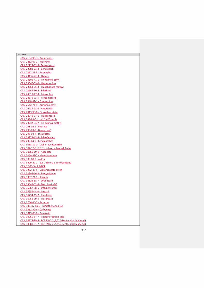
346
Pollutant
CAS_2104-96-3 - Bromophos
CAS_2212-67-1 - Molinate
CAS_22224-92-6 - Fenamiphos
CAS_22781-23-3 - Bendiocarb
CAS_2312-35-8 - Propargite
CAS_23135-22-0 - Oxamyl
CAS_23505-41-1 - Pirimiphos-ethyl
CAS_23560-59-0 - Heptenophos
CAS_23564-05-8 - Thiophanate-methyl
CAS_23947-60-6 - Ethirimol
CAS_24017-47-8 - Triazophos
CAS_24579-73-5 - Propamocarb
CAS_2540-82-1 - Formothion
CAS_2642-71-9 - Azinphos-ethyl
CAS_26787-78-0 - Amoxicillin
CAS_2813-95-8 - Dinoseb acetate
CAS_28249-77-6 - Thiobencarb
CAS_288-88-0 - 1H-1,2,4-Triazole
CAS_29232-93-7 - Pirimiphos-methyl
CAS_298-02-2 - Phorate
CAS_298-03-3 - Demeton-O
CAS_298-04-4 - Disulfoton
CAS_29973-13-5 - Ethiofencarb
CAS_299-84-3 - Fenchlorphos
CAS_3018-12-0 - Dichloroacetonitrile
CAS_302-17-0 - 2,2,2-trichloroethane-1,1-diol
CAS_30560-19-1 - Acephate
CAS_3060-89-7 - Metobromuron
CAS_309-00-2 - Aldrin
CAS_3209-22-1 - 1,2-Dichloro-3-nitrobenzene
CAS_32-23-5 - 2,4-DEP
CAS_3252-43-5 - Dibromoacetonitrile
CAS_32809-16-8 - Procymidone
CAS_3337-71-1 - Asulam
CAS_34622-58-7 - Orbencarb
CAS_35045-02-4 - Metribuzin-DA
CAS_35367-38-5 - Diflubenzuron
CAS_35554-44-0 - Imazalil
CAS_36734-19-7 - Iprodione
CAS_36756-79-3 - Tiocarbazil
CAS_3766-60-7 - Buturon
CAS_380412-59-9 - Dimethenamid OA
CAS_3812-32-6 - Carbonate
CAS_3813-05-6 - Benazolin
CAS_38260-54-7 - Phosphorothioic acid
CAS_38379-99-6 - PCB 95 (2,2',3,5',6-Pentachlorobiphenyl)
CAS_38380-01-7 - PCB 99 (2,2',4,4',5-Pentachlorobiphenyl)

347
Pollutant
CAS_38380-03-9 - PCB 110 (2,3,3',4',6-Pentachlorobiphenyl)
CAS_38380-04-0 - PCB 149 (2,2',3,4',5',6-Hexachlorobiphenyl)
CAS_38939-88-7 - 3-chloro-4-nitrotoluene
CAS_3984-14-3 - N,N-dimethylsulfamide
CAS_41483-43-6 - Bupirimate
CAS_4245-76-5 - N-methyl-N'-nitroguanidine
CAS_42874-03-3 - Oxyfluorfen
CAS_43121-43-3 - Triadimefon
CAS_50-28-2 - 17beta-estradiol (E2)
CAS_50-31-7 - 2,3,6-trichlorobenzoic acid
CAS_50471-44-8 - Vinclozolin
CAS_506-77-4 - Cyanogen chloride
CAS_5103-71-9 - Alpha-Chlordan
CAS_5103-74-2 - Trans-chlordane
CAS_51908-16-8 - PCB 146 (2,2',3,4',5,5'-Hexachlorobiphenyl)
CAS_525-66-6 - Propranolol
CAS_52663-63-5 - PCB 151 (2,2',3,5,5',6-Hexachlorobiphenyl)
CAS_52663-68-0 - PCB 187 (2,2',3,4',5,5',6-Heptachlorobiphenyl)
CAS_52663-69-1 - PCB 183 (82,2',3,4,4',5',6-Heptachloro-1,1'-biphenyl)
CAS_52663-70-4 - PCB 177 (3,3',4',5,6-Heptachlorobiphenyl)
CAS_52-68-6 - Trichlorfon
CAS_52888-80-9 - Prosulfocarb
CAS_52918-63-5 - Deltamethrin
CAS_53112-28-0 - Pyrimethanil
CAS_5367-28-2 - 3-chloro-6-nitrotoluene
CAS_542-75-6 - 1,3-dichloropropene
CAS_54910-89-3 - Fluoxetine
CAS_55179-31-2 - Bitertanol
CAS_55219-65-3 - Triadimenol
CAS_55335-06-3 - Triclopyr
CAS_55-38-9 - Fenthion
CAS_554-00-7 - 2,4-dichloroaniline
CAS_555-37-3 - Neburon
CAS_556-88-7 - Nitroguanidine
CAS_563-12-2 - Ethion
CAS_56-55-3 - Benzo(a)anthracene
CAS_56-72-4 - Coumaphos
CAS_57018-04-9 - Tolclofos methyl
CAS_57-12-5 - Free cyanide
CAS_57646-30-7 - Furalaxyl
CAS_57966-95-7 - Cymoxanil
CAS_60168-88-9 - Fenarimol
CAS_60-57-1 - Dieldrin
CAS_608-27-5 - 2,3-Dichloroaniline
CAS_608-31-1 - 2,6-Dichloroaniline
CAS_609-19-8 - 3,4,5-Trichlorophenol
CAS_61-82-5 - Aminotriazole
Con formato: Español (España)

348
Pollutant
CAS_611-06-3 - 2,4-Dichloro-1-nitrobenzene
CAS_615-65-6 - 2-Chloro-4-methylaniline
CAS_62-53-3 - Aniline
CAS_626-43-7 - 3,5-Dichloroaniline
CAS_63-25-2 - Carbaryl
CAS_66215-27-8 - Cyromazine
CAS_66246-88-6 - Penconazole
CAS_67-72-1 - Hexachloroethane
CAS_67747-09-5 - Prochloraz
CAS_69327-76-0 - Buprofezin
CAS_69377-81-7 - Fluroxypyr
CAS_709-98-8 - Propanil
CAS_71626-11-4 - Benalaxyl
CAS_72178-02-0 - Fomesafen
CAS_731-27-1 - Tolylfluanid
CAS_732-11-6 - Fosmet
CAS_7440-21-3 - Silicon
CAS_7440-44-0 - Carbon
CAS_74-87-3 - Methyl chloride
CAS_75-21-8 - Ethylene oxide
CAS_75-27-4 - Bromodichloromethane
CAS_76-13-1 - 1,1,2-trichlorotrifluoroethane
CAS_76578-12-6 - Quizalofop
CAS_7664-41-7 - Ammonia
CAS_77238-39-2 - Microcystin
CAS_77732-09-3 - Oxadixyl
CAS_7786-34-7 - Mevinphos
CAS_7790-93-4 - Chloric acid
CAS_786-19-6 - Carbophenothion
CAS_78-88-6 - 2,3-dichloropropene
CAS_79-06-1 - Acrylamide
CAS_79-11-8 - Chloroacetic acid
CAS_79241-46-6 - Fluazifop-P-butyl
CAS_79277-27-3 - Thifensulfuron-methyl
CAS_79-43-6 - Dichloroacetic acid
CAS_79-57-2 - Oxytetracycline
CAS_8065-48-3 - Demeton-O and Demeton-S (mixture)
CAS_80844-07-1 - Etofenprox
CAS_81406-37-3 - Fluroxypyr-meptyl
CAS_81777-89-1 - Clomazone
CAS_82097-50-5 - Triasulfuron
CAS_82558-50-7 - Benzamide
CAS_83055-99-6 - Bensulfuron-methyl
CAS_83164-33-4 - Diflufenican
CAS_83-42-1 - 2-chloro-6-nitrotoluene
CAS_85509-19-9 - Flusilazole
CAS_85721-33-1 - Ciprofloxacin

349
Pollutant
CAS_86209-51-0 - Primisulfuron-methyl
CAS_86-50-0 - Azinphos-methyl
CAS_87-60-5 - 3-chloro-o-toluidine
CAS_87674-68-8 - Dimethenamid
CAS_87820-88-0 - Tralkoxydim
CAS_88671-89-0 - Myclobutanil
CAS_88-73-3 - 1-chloro-2-nitrobenzene
CAS_89-21-4 - 4-chloro-2-nitroanisole
CAS_89-59-8 - 4-Chloro-2-nitrotoluene
CAS_89-60-1 - 4-chloro-3-nitrotoluene
CAS_89-61-2 - 1,4-dichloro-2-nitrobenzene
CAS_89-63-4 - 4-chloro-2-nitroaniline
CAS_90-13-1 - 1-Chloronaphthalene
CAS_9016-45-9 - Nonylphenol ethoxylate
CAS_91-94-1 - 3,3'-dichlorobenzidine
CAS_92-52-4 - Biphenyl
CAS_92-87-5 - Benzidine
CAS_933-75-5 - 2,3,6-Trichlorophenol
CAS_933-78-8 - 2,3,5-trichlorophenol
CAS_94125-34-5 - Prosulfuron
CAS_944-22-9 - Fonofos
CAS_950-37-8 - Methidathion
CAS_95-16-9 - Benzosulfonazole
CAS_95465-99-9 - Cadusafos
CAS_95-51-2 - 2-chloroaniline
CAS_95-57-8 - 2-chlorophenol
CAS_95617-09-7 - Fenoxaprop
CAS_95-74-9 - 3-chloro-p-toluidine
CAS_95-76-1 - 3,4-dichloroaniline
CAS_95-79-4 - 5-chloro-o-toluidine
CAS_95-82-9 - 2,5-dichloroaniline
CAS_95-85-2 - 2-amino-4-chlorophenol
CAS_95-94-3 - 1,2,4,5-tetrachlorobenzene
CAS_96-23-1 - 1,3-dichloropropan-2-ol
CAS_96489-71-3 - Pyridaben
CAS_97-00-7 - 1-chloro-2,4-dinitrobenzene
CAS_98-87-3 - a,a-dichlorotoluene
CAS_98-95-3 - Nitrobenzene
CAS_99105-77-8 - Sulcotrione
CAS_99-30-9 - Dicloran
CAS_99-54-7 - 1,2-Dichloro-4-nitrobenzene
CAS_999-81-5 - Chlormequat chloride
EEA_32-23-5 - Total Benzo(b)fluor-anthene (CAS_205-99-2) + Benzo(k)fluor-anthene (CAS_207-08-9)
EEA_32-24-6 - Total Benzo(g,h,i)perylene (CAS_191-24-2) + Indeno(1,2,3-cd)pyrene (CAS_193-39-5)
EEA_33-08-9 - Chromium (III)
EEA_33-56-7 - Total PAHs (Benzo(a)pyrene, Benzo(b)fluoranthene, Benzo(k)fluoranthene, Benzo(ghi)perylene, Indeno(1,2,3-cd)pyrene)
EEA_33-59-0 - Nonylphenol and nonylphenol ethoxylates (NP + NPEs)

350
Pollutant
EEA_33-60-3 - Organotin compounds (as total Sn)
EEA_33-61-4 - Triphenyltin and compounds
EEA_33-62-5 - Total PAHs (4 PAHs: Benzo(a)pyrene, Benzo(b)fluoranthene, Benzo(k)fluoranthene, Indeno(1,2,3-cd)pyrene)
EEA_33-63-6 - Total brominated diphenylethers (penta-BDE + octa-BDE + deca-BDE)
EEA_33-64-7 - Total cyanide
EEA_33-65-8 - Oxydemeton-methyl
CAS_18785-72-3 - Sulphate
EEA_31-02-7 - Total suspended solids
EEA_31-03-8 - Total dissolved solids
EEA_3133-05-9 - Dissolved organic carbon (DOC)
EEA_3161-01-1 - Kjeldahl nitrogen
EEA_3161-02-2 - Total oxidised nitrogen
EEA_31613-01-1 - Non-ionised ammonia
EEA_3163-01-7 - Silicate
CAS_132-65-0 - Dibenzothiophene
CAS_1576-67-6 - 3,6-dimethylphenanthrene
CAS_16606-02-3 - PCB 31
CAS_2437-79-8 - PCB 47
CAS_2531-84-2 - 2-methylphenanthrene
EEA_33-73-8 - Total heptachlorinated dibenzofurans EEA_33-74-9 - Total 20 PFAS (Drinking Water Directive - PFBA, PFPA, PFHxA, PFHpA, PFOA, PFNA, PFDA, PFUnDA, PFDoDA, PFTrDA, PFBS, PFPS, PFHxS, PFHpS, PFOS, PFNS, PFDS,PFUnS, PFDoS, PFTrS)
EEA_33-75-0 - Heptachlor epoxide - cis+trans
EEA_33-76-1 - Hydrocarbons index NF EN ISO 9377-2
EEA_33-77-2 - Dimethachlor CGA 369873
CAS_2706-90-3 - Perfluoro-n-pentanoic acid
CAS_27619-97-2 - Perfluorohexylethylsulfonic acid
CAS_307-24-4 - Undecafluorohexanoic acid
CAS_32598-10-0 - PCB 66
CAS_32690-93-0 - PCB 74
CAS_33025-41-1 - PCB 60
CAS_355-46-4 - Perfluorohexane-1-sulphonic acid
CAS_375-22-4 - Heptafluorobutyric acid
CAS_375-73-5 - Perfluorobutane sulfonic acid
CAS_375-85-9 - Perfluoroheptanoic acid
CAS_375-95-1 - Perfluorononanoic acid
CAS_335-76-2 - Nonadecafluorodecanoic acid
CAS_37680-65-2 - PCB 18
CAS_38380-07-3 - PCB 128
CAS_38444-86-9 - PCB 33
CAS_7440-46-2 - Cesium
CAS_74472-42-7 - PCB 158
CAS_76842-07-4 - PCB 122
CAS_832-69-9 - 1-methylphenanthrene
CAS_832-71-3 - 3-methylphenanthrene
CAS_883-20-5 - 9-methylphenanthrene
CAS_91538-84-0 - 1,2,3,4,7,9-hexachlorodibenzofuran
Con formato: Español (España)
Con formato: Español (España)

351
Pollutant
CAS_935-95-5 - 2,3,5,6-tetrachlorophene
EEA_33-66-9 - Total PAHs (3 PAHs: Benzo(b)fluoranthene + benzo(j)fluoranthene + benzo(k)fluoranthene)
EEA_33-67-0 - Total PCB 28 + PCB 31 (2,4,4'-trichlorobiphenyl + 2,4',5-trichlorobiphenyl)
EEA_33-68-1 - Total pentachlorinated dibenzofurans (1,2,3,4,8-pentachlorodibenzofuran + 1,2,3,7,8-pentachlorodibenzofuran)
EEA_33-69-2 - Total hexachlorinated dibenzofurans (1,2,3,4,7,8-hexachlorodibenzofuran + 1,2,3,4,7,9-hexachlorodibenzofuran
EEA_33-70-5 - Total tetrachlorinated dibenzofurans
EEA_33-71-6 - Total pentachlorinated dibenzofurans
EEA_33-72-7 - Total hexachlorinated dibenzofurans
CAS_40186-72-9 - PCB 206
CAS_41464-40-8 - PCB 49
CAS_52712-04-6 - PCB 141
CAS_571-61-9 - 1,5-dimethylnaphthalene
CAS_575-43-9 - 1,6-dimethylnaphthalene
CAS_581-42-0 - 2,6-dimethylnaphthalene
CAS_604-83-1 - 9,10-dimethylphenanthrene
CAS_634-66-2 - 1,2,3,4-tetrachlorophene
CAS_634-90-2 - 1,2,3,5-tetrachlorophene
CAS_67517-48-0 - 1,2,3,4,8-pentachlorodibenzofuran
CAS_68194-04-7 - PCB 51
CAS_112281-77-3 - Tetraconazole
CAS_125116-23-6 - Metconazole
CAS_125225-28-7 - Ipconazole
CAS_131807-57-3 - Famoxadone
CAS_149961-52-4 - Dimoxystrobin
CAS_22916-47-8 - Miconazole
CAS_86386-73-4 - Fluconazole
CAS_93413-62-8 - O-desmethylvenlafaxine
CAS_93413-69-5 - Venlafaxine
EEA_33-54-5 - Dioxin-like polychlorinated biphenyls (12 PCB-DLs: 77,81,105,114,118,123,126,156,157,167,169,189)
CAS_111988-49-9 - Thiacloprid
CAS_114-07-8 - Erythromycin
CAS_128-37-0 - 2,6-ditert-butyl-4-methylphenol
CAS_134237-50-6 - alpha-Hexabromocyclododecane
CAS_134237-51-7 - beta-Hexabromocyclododecane
CAS_134237-52-8 - gamma-Hexabromocyclododecane
CAS_141776-32-1 - Sulfosulfuron
CAS_15307-79-6 - Diclofenac sodium
CAS_153719-23-4 - Thiamethoxam
CAS_193-39-5 - Indeno(1,2,3-cd)pyrene
CAS_19408-74-3 - 1,2,3,7,8,9-H6CDD
CAS_2032-65-7 - Methiocarb
CAS_210880-92-5 - Clothianidin
CAS_2303-17-5 - Tri-allate
CAS_25637-99-4 - 1,3,5,7,9,11-hexabromocyclododecane
CAS_301-12-2 - Oxydemeton-methyl
CAS_3194-55-6 - 1,2,5,6,9,10-hexabromocyclododecane
CAS_32534-81-9 - Pentabromodiphenylether
Con formato: Español (España)

352
Pollutant
CAS_3268-87-9 - 1,2,3,4,6,7,8,9-O8CDD
CAS_3380-34-5 - Triclosan
CAS_35822-46-9 - 1,2,3,4,6,7,8-H7CDD
CAS_36483-60-0 - Hexabromodiphenylether
CAS_39001-02-0 - 1,2,3,4,6,7,8,9-O8CDF
CAS_39227-28-6 - 1,2,3,4,7,8-H6CDD
CAS_40088-47-9 - Tetrabromodiphenylether
CAS_40321-76-4 - 1,2,3,7,8-P5CDD
CAS_41464-42-0 - PCB 72 (2,3',5,5'-Tetrachlorobiphenyl)
CAS_465-73-6 - Isodrin
CAS_51207-31-9 - 2,3,7,8-T4CDF
CAS_52-51-7 - Bronopol
CAS_53-16-7 - Estrone (E1)
CAS_5466-77-3 - 2-ethylhexyl 4-methoxycinnamate
CAS_55673-89-7 - 1,2,3,4,7,8,9-H7CDF
CAS_57117-31-4 - 2,3,4,7,8-P5CDF
CAS_57117-41-6 - 1,2,3,7,8-P5CDF
CAS_57117-44-9 - 1,2,3,6,7,8-H6CDF
CAS_57653-85-7 - 1,2,3,6,7,8-H6CDD
CAS_60851-34-5 - 2,3,4,6,7,8-H6CDF
CAS_67562-39-4 - 1,2,3,4,6,7,8-H7CDF
CAS_68928-80-3 - BDE 183 (Heptabromodiphenylether)
CAS_70648-26-9 - 1,2,3,4,7,8-H6CDF
CAS_72-20-8 - Endrin
CAS_72918-21-9 - 1,2,3,7,8,9-H6CDF
CAS_85535-85-9 - Chloroalkanes C14-17,MCCP
EEA_33-50-1 - Heptachlor and heptachlor epoxide
EEA_33-51-2 - Total macrolide antibiotics (erythromycin + clarithromycin + azithromycin)
EEA_33-52-3 - Total neonicotinoid insecticides (imidacloprid + thiacloprid + thiamethoxam + clothianidin + acetamiprid)
EEA_33-53-4 - Total Estrone (E1) + 17beta-estradiol (E2)
EEA_33-55-6 - Octylphenols (CAS 1806-26-4) including isomer 4-(1,1',3,3'-tetramethylbutyl)-phenol (CAS 140-66-9)
EEA_33-58-9 - Dioxins and dioxin-like compounds (7 PCDDs + 10 PCDFs + 12 PCB-DLs)
EEA_33-57-8 - Hexabromocyclododecanes (alpha + beta + gamma + 1,3,5,7,9,11 + 1,2,5,6,9,10 -HBCDD) CAS_10028-17-8 - Tritium
CAS_100-41-4 - Ethylbenzene
CAS_100-42-5 - Styrene
CAS_1007-28-9 - Desisopropylatrazine
CAS_1014-69-3 - Desmetryn
CAS_101-55-3 - 4-bromophenyl phenyl ether
CAS_1024-57-3 - Heptachlor epoxide
CAS_10265-92-6 - Methamidophos
CAS_103-65-1 - n-propylbenzene
CAS_104-35-8 - 4-nonylphenol mono-ethoxylate (NP1EO)
CAS_104-51-8 - n-butylbenzene
CAS_105-67-9 - 2,4-dimethyl-phenol
CAS_10605-21-7 - Carbendazim
CAS_106-42-3 - P-xylene
Con formato: Español (España)

353
Pollutant
CAS_106-43-4 - 4-chlorotoluene
CAS_106-44-4 - 4-methyl-phenol
CAS_106-44-5 - P-cresol
CAS_106-46-7 - 1,4-dichlorobenzene
CAS_1066-51-9 - Aminomethylphosphonic acid (AMPA)
CAS_106-93-4 - 1,2-dibromoethane
CAS_1070-78-6 - 1,1,1,3-tetrachloropropane
CAS_107-13-1 - Acrylonitrile
CAS_1071-83-6 - Glyphosate
CAS_107-46-0 - Hexamethyldisiloxane (HMDS)
CAS_108-38-3 - M-xylene
CAS_108-67-8 - 1,3,5-trimethylbenzene
CAS_108-70-3 - 1,3,5-trichlorobenzene
CAS_108-86-1 - Bromobenzene
CAS_108-88-3 - Toluene
CAS_108-90-7 - Chlorobenzene
CAS_108-95-2 - Phenol
CAS_1113-02-6 - Omethoate
CAS_112410-23-8 - Tebufenozide
CAS_1163-19-5 - Bis(pentabromophenyl) ether
CAS_118-96-7 - 2,4,6-trinitrotoluene
CAS_1194-65-6 - Dichlobenil
CAS_120-36-5 - Dichlorprop (2,4-DP)
CAS_120-82-1 - 1,2,4-trichlorobenzene
CAS_120-83-2 - 2,4-dichlorophenol
CAS_120928-09-8 - Fenazaquin
CAS_121-14-2 - 2,4-dinitrotoluene
CAS_121-75-5 - Malathion
CAS_122-14-5 - Fenitrothion
CAS_1231244-60-2 - Metazachlor OA
CAS_123-33-1 - Maleinhydrazid
CAS_124-48-1 - Dibromochlorometane
CAS_12767-79-2 - Aroclor
CAS_129-00-0 - Pyrene
CAS_13071-79-9 - Terbufos
CAS_131-11-3 - Dimethyl phthalate
CAS_131-16-8 - Dipropyl phthalate
CAS_131-18-0 - Dipentyl phthalate
CAS_1321-64-8 - Pentachloronaphthalene
CAS_1321-65-9 - Trichloronaphthalene
CAS_1330-20-7 - Xylene
CAS_133-06-2 - Captan
CAS_13351-73-0 - Tolyltriazole
CAS_13356-08-6 - Fenbutatin oxide
CAS_1335-87-1 - Hexachloronaphthalene
CAS_1335-88-2 - Tetrachloronaphthalene
CAS_1336-36-3 - Polychlorinated biphenyls

354
Pollutant
CAS_133855-98-8 - Epoxiconazole
CAS_134-62-3 - Diethyltoluamide (DEET)
CAS_135-19-3 - 2-naphthol
CAS_135-98-8 - sec-butylbenzene
CAS_136426-54-5 - Fluquinconazole
CAS_136677-10-6 - Polychlorinated dibenzofurans (PCDF)
CAS_13684-56-5 - Desmedipham
CAS_136-85-6 - Methylbenzotriazol
CAS_137-26-8 - Thiram
CAS_137-30-4 - Ziram
CAS_139-13-9 - NTA
CAS_139-40-2 - Propazine
CAS_140-57-8 - Aramite
CAS_142-28-9 - 1,3-dichloropropane
CAS_142363-53-9 - Alachlor ESA
CAS_14265-44-2 - Phosphate
CAS_143-50-0 - Chlordecone (Kepone)
CAS_144-49-0 - Fluoroacetic acid
CAS_14797-65-0 - Nitrite
CAS_14798-03-9 - Ammonium
CAS_151-21-3 - Sodium dodecyl sulfate
CAS_15165-67-0 - Dichlorprop-P
CAS_152019-73-3 - Metolachlor OA
CAS_15307-86-5 - Diclofenac
CAS_15541-45-4 - Bromate
CAS_15545-48-9 - Chlortoluron
CAS_1563-66-2 - Carbofuran
CAS_156-59-2 - Cis-1,2-dichloroethene
CAS_15687-27-1 - Ibuprofen
CAS_1570-64-5 - 4-chloro-2-methylphenol
CAS_1570-65-6 - 4,6-dichloro-2-methylphenol
CAS_1610-18-0 - Prometon
CAS_16118-49-3 - Carbetamide
CAS_1634-04-4 - MTBE
CAS_16478-18-5 - Pentachloroiodobenzene
CAS_16484-77-8 - Mecoprop-P (MCPP-P)
CAS_16655-82-6 - 3-hydroxycarbofuran
CAS_16672-87-0 - 2-chloroethylphosphonic acid
CAS_16752-77-5 - Methomyl
CAS_1689-83-4 - Ioxynil
CAS_1689-84-5 - Bromoxynil
CAS_1689-99-2 - Bromoxynil octanoate
CAS_16984-48-8 - Fluoride
CAS_1698-60-8 - Chloridazon
CAS_1702-17-6 - Clopyralid
CAS_17040-19-6 - Demeton-S-methylsulfon
CAS_171118-09-5 - Metolachlor ESA

355
Pollutant
CAS_171262-17-2 - Alachlor OA
CAS_17254-80-7 - Chloridazon methyl desphenyl
CAS_172960-62-2 - Metazachlor ESA
CAS_1746-01-6 - 2,3,7,8-tetrachlorodibenzo-p-dioxin
CAS_1806-26-4 - 4-octylphenol
CAS_18181-70-9 - Iodofenphos
CAS_182346-21-0 - 2,2',3,4,4'-pentabromodiphenyl ether (BDE85)
CAS_1825-21-4 - Pentachloroanisole
CAS_182677-30-1 - 2,2',3,4,4',5'-hexabromodiphenyl Ether (BD(E)138)
CAS_1836-75-5 - Nitrophen
CAS_1861-40-1 - Benfluralin
CAS_187022-11-3 - Acetochlor ESA
CAS_189084-64-8 - 2,2',4,4',6-pentabromodiphenyl Ether (BD(E)100)
CAS_1912-26-1 - Trietazine
CAS_1918-00-9 - Dicamba
CAS_1918-13-4 - Chlorthiamid
CAS_194992-44-4 - Acetochlor OA
CAS_2008-58-4 - 2,6-dichlorobenzamide
CAS_20427-84-3 - 4-nonylphenol di-ethoxylate (NP2EO)
CAS_20461-54-5 - Iodide
CAS_2051-24-3 - 5,5',6,6'-decachlorobiphenyl (CB209)
CAS_207122-15-4 - 2,2',4,4',5,6'-hexabromodiphenyl Ether (BDE154)
CAS_208-96-8 - Acenaphthylene
CAS_2104-64-5 - Ethyl O-(p-nitrophenyl) phenyl phosphonothionate (EPN)
CAS_21087-64-9 - Metribuzin
CAS_2163-68-0 - Hydroxyatrazine
CAS_2164-08-1 - Lenacil
CAS_21725-46-2 - Cyanazine
CAS_218-01-9 - Chrysene
CAS_22204-53-1 - Naproxen
CAS_2227-13-6 - Tetrasul
CAS_2234-13-1 - Octachloronaphthalene
CAS_2310-17-0 - Phosalone
CAS_23103-98-2 - Pirimicarb
CAS_23593-75-1 - Clotrimazole
CAS_2385-85-5 - Mirex
CAS_23950-58-5 - Propyzamide
CAS_2440-02-0 - Heptachloronorbornene
CAS_24959-67-9 - Bromide
CAS_25057-89-0 - Bentazone
CAS_25140-90-3 - 2-(2,6-dichlorophenoxy)propionic acid (2,6-DCPP)
CAS_25154-52-3 - Nonylphenol
CAS_25167-83-3 - Tetrachlorophenols
CAS_2599-11-3 - Hydroxysimazine
CAS_262-12-4 - Dibenzodioxin
CAS_26225-79-6 - Ethofumesate
CAS_26259-45-0 - Secbumeton

356
Pollutant
CAS_29122-68-7 - Atenolol
CAS_294-62-2 - Cyclododecane
CAS_297-78-9 - Isobenzane
CAS_298-00-0 - Parathion-methyl
CAS_298-46-4 - Carbamazepin
CAS_30125-63-4 - Desethylterbuthylazine
CAS_3115-49-9 - Nonylphenoxyacetic acid (NPE1C)
CAS_31218-83-4 - Propetamphos
CAS_314-40-9 - Bromacil
CAS_31508-00-6 - 2,3',4,4',5-pentachlorobiphenyl (CB118)
CAS_319-84-6 - Alpha-HCH
CAS_319-85-7 - Beta-HCH
CAS_319-86-8 - Delta-HCH
CAS_32241-08-0 - Heptachloronaphthalene
CAS_32536-52-0 - Diphenyl ether/ octabromo deviate
CAS_32598-13-3 - 3,3',4,4'-tetrachlorobiphenyl (CB77)
CAS_32598-14-4 - 2,3,3',4,4'-pentachlorobiphenyl (CB105)
CAS_32774-16-6 - 3,3',4,4',5,5'-hexachlorobiphenyl (CB169)
CAS_330-55-2 - Linuron
CAS_3307-39-9 - 2-(4-chlorophenoxy)propionic acid (4-CPP)
CAS_33213-65-9 - Beta-Endosulfan
CAS_333-41-5 - Diazinon
CAS_335-67-1 - PFOA
CAS_33693-04-8 - Terbumeton
CAS_3397-62-4 - Deisopropyldeethylatrazine
CAS_3424-82-6 - DDE, o,p'
CAS_34256-82-1 - Acetochlor
CAS_35065-27-1 - 2,2',4,4',5,5'-hexachlorobiphenyl (CB153)
CAS_35065-28-2 - 2,2',3,4,4',5'-hexachlorobiphenyl (CB138)
CAS_35065-29-3 - 2,2',3,4,4',5,5'-heptachlorobiphenyl (CB180)
CAS_35065-30-6 - PCB170 (1,2,3,4-tetrachloro-5-(2,3,4-trichlorophenyl)benzene)
CAS_35693-99-3 - 2,2',5,5'-tetrachlorobiphenyl (CB52)
CAS_35694-08-7 - PCB194 (1,2,3,4-tetrachloro-5-(2,3,4,5-tetrachlorophenyl)benzene)
CAS_36065-30-2 - 2,4,6-tribromophenyl 2-methyl-2,3-dibromopropy ether
CAS_36355-01-8 - Hexabromobiphenyl
CAS_37350-58-6 - Metoprolol
CAS_37680-73-2 - 2,2',4,5,5'-pentachlorobiphenyl (CB101)
CAS_38380-08-4 - 2,3,3',4,4',5-hexachlorobiphenyl (CB156)
CAS_39635-31-9 - PCB189 (1,2,3,4-tetrachloro-5-(3,4,5-trichlorophenyl)benzene)
CAS_39765-80-5 - trans-Nonachlor
CAS_40487-42-1 - Pendimethalin
CAS_41318-75-6 - PBDE28
CAS_41394-05-2 - Metamitron
CAS_41859-67-0 - Bezafibrate
CAS_4234-79-1 - Kelevan
CAS_4636-83-3 - Morfamquat
CAS_4901-51-3 - 2,3,4,5-tetrachlorophenol
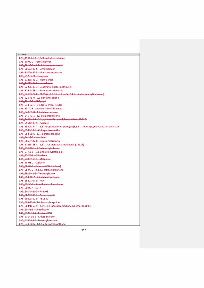
357
Pollutant
CAS_4904-61-4 - 1,5,9-cyclododecatriene
CAS_50-00-0 - Formaldehyde
CAS_50-30-6 - 2,6-dichlorobenzoic acid
CAS_50563-36-5 - Dimethachlor
CAS_51000-52-3 - Vinyl neodecanoate
CAS_512-04-9 - Diosgenin
CAS_51218-45-2 - Metolachlor
CAS_51235-04-2 - Hexazinone
CAS_52236-30-3 - Desamino-diketo-metribuzin
CAS_52645-53-1 - Permethrin-cis+trans
CAS_52663-72-6 - PCB167 (1,2,3-trichloro-5-(2,4,5-trichlorophenyl)benzene)
CAS_526-75-0 - 2,3-dimethyl-phenol
CAS_53-19-0 - DDD, o,p'
CAS_534-52-1 - Dinitro-o-cresol (DNOC)
CAS_53-70-3 - Dibenzo(a,h)anthracene
CAS_540-59-0 - 1,2-dichloroethene
CAS_541-73-1 - 1,3-dichlorobenzene
CAS_5436-43-1 - 2,2',4,4'-tetrabromodiphenyl ether (BDE47)
CAS_55512-33-9 - Pyridate
CAS_55525-54-7 - 3,3'-(ureylenedimethylene)bis(3,5,5'- trimethylcyclohexyl) diisocyanate
CAS_5598-13-0 - Chlorpyrifos-methyl
CAS_563-58-6 - 1/1-dichloropropene
CAS_56-38-2 - Parathion
CAS_56507-37-0 - Diketo-metribuzin
CAS_57465-28-8 - 3,3',4,4',5-pentachlorobiphenyl (CB126)
CAS_576-26-1 - 2,6-dimethyl-phenol
CAS_57-63-6 - 17alpha-ethinylestradiol
CAS_57-74-9 - Chlordane
CAS_57837-19-1 - Metalaxyl
CAS_58-08-2 - Caffeine
CAS_58-89-9 - Gamma-HCH (Lindane)
CAS_58-90-2 - 2,3,4,6-tetrachlorophenol
CAS_5915-41-3 - Terbuthylazine
CAS_594-20-7 - 2,2-dichloropropane
CAS_59473-04-0 - AOX
CAS_59-50-7 - 3-methyl-4-chlorophenol
CAS_60-00-4 - EDTA
CAS_60145-21-3 - PCB103
CAS_60207-90-1 - Propiconazole
CAS_60328-60-9 - PBDE99
CAS_603-35-0 - Triphenyl phosphine
CAS_60348-60-9 - 2,2',4,4',5-pentabromodiphenyl ether (BDE99)
CAS_60-51-5 - Dimethoate
CAS_6108-10-7 - Epsilon-HCH
CAS_6164-98-3 - Chlordimeform
CAS_6190-65-4 - Desethylatrazine
CAS_630-20-6 - 1,1,1,2-tetrachloroethane

358
Pollutant
CAS_6339-19-1 - Chloridazon desphenyl
CAS_64743-03-9 - Phenols
CAS_64902-72-3 - Chlorsulfuron
CAS_65510-44-3 - PCB123 (1,2,3-trichloro-5-(2,4-dichlorophenyl)benzene)
CAS_66753-07-9 - Hydroxyterbuthylazine
CAS_67129-08-2 - Metazachlor
CAS_67564-91-4 - Fenpropimorph
CAS_68631-49-2 - 2,2',4,4',5,5'-hexabromodiphenyl ether (BD(E)153)
CAS_688-73-3 - Tributyltin compounds
CAS_69782-90-7 - 2,3,3',4,4',5'-hexachlorobiphenyl (CB157)
CAS_7012-37-5 - 2,4,4'-trichlorobiphenyl (CB28)
CAS_70124-77-5 - Flucythrinate
CAS_70362-41-3 - PCB106
CAS_70362-50-4 - PCB81 (3,4,4',5-tetrachlorobiphenyl)
CAS_70630-17-0 - Metalaxyl-M
CAS_70776-03-3 - Naphthalene, chloro derivatives
CAS_7085-19-0 - Mecoprop
CAS_71-55-6 - 1,1,1-trichloroethane
CAS_723-46-6 - Sulfamethoxazol
CAS_72-43-5 - Methoxychlor
CAS_72-54-8 - DDD, p,p'
CAS_72-55-9 - DDE, p,p'
CAS_7286-69-3 - Sebuthylazine
CAS_7287-19-6 - Prometryn
CAS_732-26-3 - 2,4,6-tri-tert-butylphenol
CAS_738-70-5 - Trimethoprim
CAS_74223-64-6 - Metsulfuronmethyl
CAS_7429-90-5 - Aluminium
CAS_7439-89-6 - Iron
CAS_7439-93-2 - Lithium
CAS_7439-95-4 - Magnesium
CAS_7439-96-5 - Manganes
CAS_7439-98-7 - Molybdenum
CAS_7440-09-7 - Potassium
CAS_7440-22-4 - Silver
CAS_7440-23-5 - Sodium
CAS_7440-24-6 - Strontium
CAS_7440-28-0 - Thallium
CAS_7440-31-5 - Tin
CAS_7440-32-6 - Titanium
CAS_7440-33-7 - Tungsten
CAS_7440-36-0 - Antimony
CAS_7440-38-2 - Arsenic
CAS_7440-39-3 - Barium
CAS_7440-41-7 - Beryllium
CAS_7440-42-8 - Boron
CAS_7440-47-3 - Chromium

359
Pollutant
CAS_7440-48-4 - Cobalt
CAS_7440-50-8 - Copper
CAS_7440-61-1 - Uranium
CAS_7440-62-2 - Vanadium
CAS_7440-66-6 - Zinc
CAS_7440-70-2 - Calcium
CAS_74472-37-0 - PCB114 (2,3,4,4',5-pentachlorobiphenyl)
CAS_74-83-9 - Bromomethane
CAS_74-90-8 - Hydrogen cyanide
CAS_74-95-3 - Dibromomethane
CAS_74-97-5 - Bromochloromethane
CAS_75-01-4 - Chloroethene (vinylchloride)
CAS_75-25-2 - Bromoform
CAS_75-34-3 - 1,1-dichloroethane
CAS_75-35-4 - 1,1-dichloroethene
CAS_75-69-4 - Trichlorofluoromethane
CAS_75-71-8 - Dichlorodifluoromethane
CAS_75-99-0 - Dalapon
CAS_76-03-9 - Trichloroacetic acid
CAS_76-44-8 - Heptachlor
CAS_77-47-4 - Hexachlorocyclopentadiene (HCCP)
CAS_7782-41-4 - Fluorine
CAS_7782-49-2 - Selenium
CAS_7783-06-4 - Hydrogen sulphide
CAS_78-87-5 - 1,2-dichloropropane
CAS_789-02-6 - DDT, o,p'
CAS_79-00-5 - 1,1,2-trichloroethane
CAS_793-24-8 - 4-(dimethylbutylamino) diphenylamin (6PPD)
CAS_79-34-5 - 1,1,2,2-tetrachloroethane
CAS_79-94-7 - Tetrabromobisphenol A (TBBP-A)
CAS_8001-35-2 - Toxaphene
CAS_80-05-7 - Bisphenol A
CAS_81103-11-9 - Clarithromycin
CAS_81-15-2 - Musk xylene
CAS_82-68-8 - Quintozene
CAS_83-32-9 - Acenaphthene
CAS_834-12-8 - Ametryn
CAS_83905-01-5 - Azitromycin
CAS_84-66-2 - Di-ethyl phthalate
CAS_84-69-5 - Di-iso-butyl phthalate
CAS_84-74-2 - Dibutylphthalate
CAS_84852-15-3 - 4-nonylphenol/ branched
CAS_85-01-8 - Phenanthrene
CAS_85-22-3 - Pentabromoethylbenzene
CAS_85540-50-1 - 6-chloro-2-dimethylphenol
CAS_85-68-7 - Butyl benzyl phthalate (BBP)
CAS_86-73-7 - Fluorene

360
Pollutant
CAS_87-61-6 - 1,2,3-trichlorobenzene
CAS_87-65-0 - 2,6-dichlorophenol
CAS_88-06-2 - 2,4,6-trichlorophenol
CAS_88-85-7 - Dinoseb
CAS_90-12-0 - 1-methylnaphthalene
CAS_9016-45-9 - Nonylphenol ethoxylate
CAS_91-57-6 - 2-methylnaphthalene
CAS_919-86-8 - Demeton-S-methyl
CAS_93-72-1 - Fenoprop
CAS_93-76-5 - 2,4,5-T
CAS_94-74-6 - MCPA
CAS_94-75-7 - 2,4-dichlorophenoxyacetic acid, 2-4 D
CAS_94-81-5 - MCPB
CAS_94-82-6 - 2,4-DB
CAS_95-14-7 - Benzotriazol
CAS_95-47-6 - O-xylene
CAS_95-48-7 - 2-methyl-phenol
CAS_95-49-8 - 2-chlorotoluene
CAS_95-50-1 - 1,2-dichlorobenzene
CAS_95-63-6 - 1,2,4-trimethylbenzene
CAS_95-65-8 - 3,4-dimethyl-phenol
CAS_95-87-4 - 2,5-dimethylphenol
CAS_95-95-4 - 2,4,5-trichlorophenol
CAS_959-98-8 - Alpha-Endosulfan
CAS_96-12-8 - 1,2-dibromo-3-chloropropane
CAS_96-18-4 - 1,2,3-trichloropropane
CAS_96-45-7 - Ethylenethiourea (ETU)
CAS_98-06-6 - tert-butylbenzene
CAS_98-51-1 - 4-tert-butyltoluene
CAS_98-82-8 - Isopropylbenzene
CAS_994-05-8 - TAME
CAS_99-87-6 - 4-isopropyltoluene
EEA_00-00-0 - Other chemical parameter
EEA_33-01-2 - Alkalised benzene
EEA_33-02-3 - Benzol
EEA_33-03-4 - Brominated diphenylethers
EEA_33-04-5 - Brominated flame retardants
EEA_33-05-6 - BTEX
EEA_33-06-7 - Chlorinated benzene
EEA_33-07-8 - Chlorinated phenol
EEA_33-09-0 - Detergents
EEA_33-10-3 - Dichlorobenzene
EEA_33-11-4 - Dichlorophenol
EEA_33-12-5 - Dioxins and dioxin-like compounds
EEA_33-13-6 - DOX
EEA_33-14-7 - Extractable organically bound chlorine
EEA_33-15-8 - Halogenated organic compounds

361
Pollutant
EEA_33-16-9 - Hexabromocyclododecanes (HBCDD)
EEA_33-17-0 - Hydrocarbons
EEA_33-18-1 - Meta xylene + para xylene
EEA_33-19-2 - Mono basic phenols
EEA_33-20-5 - Monochlorophenols
EEA_33-21-6 - Nitrobenzene
EEA_33-22-7 - Oil fractions (C10-40)
EEA_33-23-8 - Petroleum hydrocarbons
EEA_33-24-9 - Petroleum products
EEA_33-25-0 - Polyaromatic hydrocarbons (PAH)
EEA_33-26-1 - Polychlorinated dibenzodioxins (PCDD)
EEA_33-27-2 - Radionuclides
EEA_33-28-3 - Surfactants (anionic and nonionic)
EEA_33-29-4 - Surfactants (anionic)
EEA_33-30-7 - TCDD (dioxins and furans)
EEA_33-31-8 - Total chrysene + triphenylene
EEA_33-32-9 - Total DDD (TDE) (DDD, o,p' + DDD, p,p')
EEA_33-33-0 - Total DDE (DDE, o,p' and DDE, p,p') EEA_33-35-2 - Total DDT + DDE + DDD (DDT, o,p' + DDT,p,p' + DDE, o,p' + DDE, p,p' + DDD, o,p' + DDD, p,p')
EEA_33-36-3 - Total hydrocarbons
EEA_33-37-4 - Total PAH excluding bicycl
EEA_33-38-5 - Total PCBs (7 congeners: 28, 52, 101,118, 138, 153 and 180)
EEA_33-39-6 - Total PCBs
EEA_33-40-9 - Total PCDD + PCDF
EEA_33-41-0 - Total tri-, tetra- and pentachlorophenol
EEA_33-42-1 - Total trichloroethylene + tetrachloroethylene
EEA_33-43-2 - Total trihalomethanes
EEA_33-44-3 - Total highly volatile halogenated hydrocarbons
EEA_33-45-4 - Volatile halogenated hydrocarbons (VHH)
EEA_33-46-5 - Volatile organic halogens (VOX)
CAS_1002-53-5 - Dibutyltin
CAS_100-00-5 - Chloro-4-nitrobenzene
CAS_100-02-7- Nitrophenol
CAS_100-44-7 - Benzyl chloride
CAS_10061-01-5 - cis-1,3-dichloropropene
CAS_10061-02-6 - trans-1,3-dichloropropene
CAS_100646-51-3 - Quizalofop-P-ethyl
CAS_101205-02-1 - Cycloxydim
CAS_101-21-3 - Chlorpropham
CAS_101-42-8 - Fenuron
CAS_1031-07-8 - Endosulfan sulfate
CAS_104206-82-8 - Mesotrione
CAS_104-40-5 - 4-nonylphenol
CAS_105827-78-9 - Imidacloprid (Watch list only alternative code)
CAS_10599-90-3 - Chloramide
CAS_106-47-8 - 4-chloroaniline

362
Pollutant
CAS_106-48-9 - 4-chlorophenol
CAS_106700-29-2 - Pethoxamid
CAS_106-89-8 - Epichlorohydrin
CAS_107-05-1 - 3-chloropropene
CAS_107-07-3 - 2-Chloroethanol
CAS_107534-96-3 - Tebuconazole
CAS_108-41-8 - 3-chlorotoluene
CAS_108-42-9 - 3-chloroaniline
CAS_108-43-0 - 3-chlorophenol
CAS_108-60-1 - Bis(2-chloro-1-methylethyl) ether
CAS_108-68-9 - 3,5-dimethyl-phenol
CAS_109-89-7 - Diethylamine
CAS_110488-70-5 - Dimethomorph
CAS_111991-09-4 - Nicosulfuron
CAS_113096-99-4 - Cyproconazole
CAS_114-26-1 - Propoxur
CAS_116-06-3 - Aldicarb
CAS_116-29-0 - Teradifon
CAS_118134-30-8 - Spiroxamine
CAS_120923-37-7 - Amidosulfuron
CAS_121552-61-2 - Cyprodinil
CAS_121-73-3 - 1-chloro-3-nitrobenzene
CAS_121776-33-8 - Furilazole
CAS_121-86-8 - 2-chloro-4-nitrotoluene
CAS_122-39-4 - Diphenylamine
CAS_122-88-3 - 4-Chlorophenoxyacetic acid (CPA 4)
CAS_122931-48-0 - Rimsulfuron
CAS_123-91-1 - 1,4-dioxane
CAS_124-40-3 - Dimethylamine
CAS_126535-15-7 - Triflusulfuron-methyl
CAS_126-73-8 - Tributyl phosphate
CAS_126-75-0 - Demeton-S
CAS_126833-17-8 - Fenhexamid
CAS_126-99-8 - 2-Chloro-1,3-butadiene
CAS_131341-86-1 - Fludioxonil
CAS_131860-33-8 - Azoxystrobin
CAS_13194-48-4 - Ethoprophos
CAS_133-07-3 - Folpet
CAS_1332-21-4 - Asbestos
CAS_1333-82-0 - Chromium trioxide (CrO3)
CAS_133-53-9 - 2,4-dichloro-3,5-dimethylphenol
CAS_13360-45-7 - Chlorbromuron
CAS_134098-61-6 - Fenpyroximate
CAS_13457-18-6 - Pyrazophos
CAS_135410-20-7 - Ethanimidamide
CAS_137641-05-5 - Picolinafen
CAS_139528-85-1 - Metosulam

363
Pollutant
CAS_139968-49-3 - Metaflumizone
CAS_140923-17-7 - Iprovalicarb
CAS_141112-29-0 - Isoxaflutole
CAS_141517-21-7 - Trifloxystrobin
CAS_1418095-02-9 - Chlorothalonil ESA (VIS-01)
CAS_142459-58-3 - Flufenacet
CAS_143390-89-0 - Kresoxim-methyl
CAS_1461-25-2 - Tetrabutyltin
CAS_14816-18-3 - Phoxim
CAS_14866-68-3 - Chlorates
CAS_14998-27-7 - Chlorite
CAS_150-68-5 - Monuron
CAS_15299-99-7 - Napropamide
CAS_156-60-5 - trans-1,2-dichloroethene
CAS_15950-66-0 - 2,3,4-Trichlorophenol
CAS_160430-64-8 - Acetamiprid
CAS_1646-87-3 - Aldicarb sulfoxide
CAS_1646-88-4 - Aldoxycarb
CAS_1668-54-8 - 2-methyl-4-amino-6-methoxy-s-triazine
CAS_1746-81-2 - Monolinuron
CAS_175013-18-0 - Carbamic acid
CAS_18181-80-1 - Bromopropylate
CAS_182636-13-1 - Imazamox
CAS_185119-76-0 - Iodosulfuron-methyl
CAS_18540-29-9 - Chromium (VI)
CAS_18691-97-9 - Methabenzthiazuron
CAS_188425-85-6 - Boscalid
CAS_189-55-9 - Dibenzo(a,i)pyrene
CAS_1897-45-6 - Chlorothalonil
CAS_191-30-0 - Dibenzo(a,l)pyrene
CAS_1918-02-1 - Picloram
CAS_1918-16-7 - Propachlor
CAS_192-65-4 - Dibenzo(a,e)pyrene
CAS_192-97-2 - Benzo[e]pyrene
CAS_1982-47-4 - Chloroxuron
CAS_198-55-0 - Perylene
CAS_19937-59-8 - Metoxuron
CAS_201668-32-8 - Flufenacet ESA
CAS_205-82-3 - Benzo(j)fluoranthene
CAS_205939-58-8 - Dimethenamid ESA
CAS_2104-96-3 - Bromophos
CAS_2212-67-1 - Molinate
CAS_22224-92-6 - Fenamiphos
CAS_22781-23-3 - Bendiocarb
CAS_2312-35-8 - Propargite
CAS_23135-22-0 - Oxamyl
CAS_23505-41-1 - Pirimiphos-ethyl
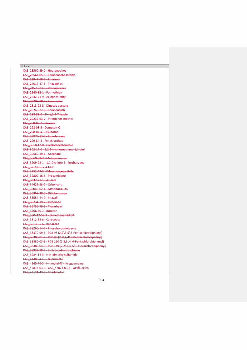
364
Pollutant
CAS_23560-59-0 - Heptenophos
CAS_23564-05-8 - Thiophanate-methyl
CAS_23947-60-6 - Ethirimol
CAS_24017-47-8 - Triazophos
CAS_24579-73-5 - Propamocarb
CAS_2540-82-1 - Formothion
CAS_2642-71-9 - Azinphos-ethyl
CAS_26787-78-0 - Amoxicillin
CAS_2813-95-8 - Dinoseb acetate
CAS_28249-77-6 - Thiobencarb
CAS_288-88-0 - 1H-1,2,4-Triazole
CAS_29232-93-7 - Pirimiphos-methyl
CAS_298-02-2 - Phorate
CAS_298-03-3 - Demeton-O
CAS_298-04-4 - Disulfoton
CAS_29973-13-5 - Ethiofencarb
CAS_299-84-3 - Fenchlorphos
CAS_3018-12-0 - Dichloroacetonitrile
CAS_302-17-0 - 2,2,2-trichloroethane-1,1-diol
CAS_30560-19-1 - Acephate
CAS_3060-89-7 - Metobromuron
CAS_3209-22-1 - 1,2-Dichloro-3-nitrobenzene
CAS_32-23-5 - 2,4-DEP
CAS_3252-43-5 - Dibromoacetonitrile
CAS_32809-16-8 - Procymidone
CAS_3337-71-1 - Asulam
CAS_34622-58-7 - Orbencarb
CAS_35045-02-4 - Metribuzin-DA
CAS_35367-38-5 - Diflubenzuron
CAS_35554-44-0 - Imazalil
CAS_36734-19-7 - Iprodione
CAS_36756-79-3 - Tiocarbazil
CAS_3766-60-7 - Buturon
CAS_380412-59-9 - Dimethenamid OA
CAS_3812-32-6 - Carbonate
CAS_3813-05-6 - Benazolin
CAS_38260-54-7 - Phosphorothioic acid
CAS_38379-99-6 - PCB 95 (2,2',3,5',6-Pentachlorobiphenyl)
CAS_38380-01-7 - PCB 99 (2,2',4,4',5-Pentachlorobiphenyl)
CAS_38380-03-9 - PCB 110 (2,3,3',4',6-Pentachlorobiphenyl)
CAS_38380-04-0 - PCB 149 (2,2',3,4',5',6-Hexachlorobiphenyl)
CAS_38939-88-7 - 3-chloro-4-nitrotoluene
CAS_3984-14-3 - N,N-dimethylsulfamide
CAS_41483-43-6 - Bupirimate
CAS_4245-76-5 - N-methyl-N'-nitroguanidine
CAS_42874-03-3 - CAS_42874-03-3 - Oxyfluorfen
CAS_43121-43-3 - Triadimefon
365
Pollutant
CAS_50-28-2 - 17 beta-estradiol (E2)
CAS_50-31-7 - 2,3,6-trichlorobenzoic acid
CAS_50471-44-8 - Vinclozolin
CAS_506-77-4 - Cyanogen chloride
CAS_5103-71-9 - Alpha-Chlordan
CAS_5103-74-2 - Trans-chlordane
CAS_51908-16-8 - PCB 146 (2,2',3,4',5,5'-Hexachlorobiphenyl)
CAS_525-66-6 - Propranolol
CAS_52663-63-5 - PCB 151 (2,2',3,5,5',6-Hexachlorobiphenyl)
CAS_52663-68-0 - PCB 187 (2,2',3,4',5,5',6-Heptachlorobiphenyl)
CAS_52663-69-1 - PCB 183 (82,2',3,4,4',5',6-Heptachloro-1,1'-biphenyl)
CAS_52663-70-4 - PCB 177 (3,3',4',5,6-Heptachlorobiphenyl)
CAS_52-68-6 - Trichlorfon
CAS_52888-80-9 - Prosulfocarb
CAS_52918-63-5 - Deltamethrin
CAS_53112-28-0 - Pyrimethanil
CAS_5367-28-2 - 3-chloro-6-nitrotoluene
CAS_542-75-6 - 1,3-dichloropropene
CAS_54910-89-3 - Fluoxetine
CAS_55179-31-2 - Bitertanol
CAS_55219-65-3 - Triadimenol
CAS_55335-06-3 - Triclopyr
CAS_55-38-9 - Fenthion
CAS_554-00-7 - 2,4-dichloroaniline
CAS_555-37-3 - Neburon
CAS_556-88-7 - Nitroguanidine
CAS_563-12-2 - Ethion
CAS_56-55-3 - Benzo(a)anthracene
CAS_56-72-4 - Coumaphos
CAS_57018-04-9 - Tolclofos methyl
CAS_57-12-5 - Free cyanide
CAS_57646-30-7 - Furalaxyl
CAS_57966-95-7 - Cymoxanil
CAS_60168-88-9 - Fenarimol
CAS_608-27-5 - 2,3-Dichloroaniline
CAS_608-31-1 - 2,6-Dichloroaniline
CAS_609-19-8 - 3,4,5-Trichlorophenol
CAS_611-06-3 - 2,4-Dichloro-1-nitrobenzene
CAS_615-65-6 - 2-Chloro-4-methylaniline
CAS_62-53-3 - Aniline
CAS_626-43-7 - 3,5-Dichloroaniline
CAS_63-25-2 - Carbaryl
CAS_66215-27-8 - Cyromazine
CAS_66246-88-6 - Penconazole
CAS_67-72-1 - Hexachloroethane
CAS_67747-09-5 - Prochloraz
CAS_69327-76-0 - Buprofezin

366
Pollutant
CAS_69377-81-7 - Fluroxypyr
CAS_709-98-8 - Propanil
CAS_71626-11-4 - Benalaxyl
CAS_72178-02-0 - Fomesafen
CAS_731-27-1 - Tolylfluanid
CAS_732-11-6 - Fosmet
CAS_7440-21-3 - Silicon
CAS_7440-44-0 - Carbon
CAS_74-87-3 - Methyl chloride
CAS_75-21-8 - Ethylene oxide
CAS_75-27-4 - Bromodichloromethane
CAS_76-13-1 - 1,1,2-trichlorotrifluoroethane
CAS_76578-12-6 - Quizalofop
CAS_7664-41-7 - Ammonia
CAS_77238-39-2 - Microcystin
CAS_77732-09-3 - Oxadixyl
CAS_7786-34-7 - Mevinphos
CAS_7790-93-4 - Chloric acid
CAS_786-19-6 - Carbophenothion
CAS_78-88-6 - 2,3-dichloropropene
CAS_79-06-1 - Acrylamide
CAS_79-11-8 - Chloroacetic acid
CAS_79241-46-6 - Fluazifop-P-butyl
CAS_79277-27-3 - Thifensulfuron-methyl
CAS_79-43-6 - Dichloroacetic acid
CAS_79-57-2 - Oxytetracycline
CAS_8065-48-3 - Demeton-O and Demeton-S (mixture)
CAS_80844-07-1 - Etofenprox
CAS_81406-37-3 - Fluroxypyr-meptyl
CAS_81777-89-1 - Clomazone
CAS_82097-50-5 - Triasulfuron
CAS_82558-50-7 - Benzamide
CAS_83055-99-6 - Bensulfuron-methyl
CAS_83-42-1 - 2-chloro-6-nitrotoluene
CAS_85509-19-9 - Flusilazole
CAS_85721-33-1 - Ciprofloxacin
CAS_86209-51-0 - Primisulfuron-methyl
CAS_86-50-0 - Azinphos-methyl
CAS_87-60-5 - 3-chloro-o-toluidine
CAS_87674-68-8 - Dimethenamid
CAS_87820-88-0 - Tralkoxydim
CAS_88671-89-0 - Myclobutanil
CAS_88-73-3 - 1-chloro-2-nitrobenzene
CAS_89-21-4 - 4-chloro-2-nitroanisole
CAS_89-59-8 - 4-Chloro-2-nitrotoluene
CAS_89-60-1 - 4-chloro-3-nitrotoluene
CAS_89-61-2 - 1,4-dichloro-2-nitrobenzene

367
Pollutant
CAS_89-63-4 - 4-chloro-2-nitroaniline
CAS_90-13-1 - 1-Chloronaphthalene
CAS_9016-45-9 - Nonylphenol ethoxylate
CAS_91-94-1 - 3,3'-dichlorobenzidine
CAS_92-52-4 - Biphenyl
CAS_92-87-5 - Benzidine
CAS_933-75-5 - 2,3,6-Trichlorophenol
CAS_933-78-8 - 2,3,5-trichlorophenol
CAS_94125-34-5 - Prosulfuron
CAS_944-22-9 - Fonofos
CAS_950-37-8 - Methidathion
CAS_95-16-9 - Benzosulfonazole
CAS_95465-99-9 - Cadusafos
CAS_95-51-2 - 2-chloroaniline
CAS_95-57-8 - 2-chlorophenol
CAS_95617-09-7 - Fenoxaprop
CAS_95-74-9 - 3-chloro-p-toluidine
CAS_95-76-1 - 3,4-dichloroaniline
CAS_95-79-4 - 5-chloro-o-toluidine
CAS_95-82-9 - 2,5-dichloroaniline
CAS_95-85-2 - 2-amino-4-chlorophenol
CAS_95-94-3 - 1,2,4,5-tetrachlorobenzene
CAS_96-23-1 - 1,3-dichloropropan-2-ol
CAS_96489-71-3 - Pyridaben
CAS_97-00-7 - 1-chloro-2,4-dinitrobenzene
CAS_98-87-3 - a,a-dichlorotoluene
CAS_98-95-3 - Nitrobenzene
CAS_99105-77-8 - Sulcotrione
CAS_99-30-9 - Dicloran
CAS_99-54-7 - 1,2-Dichloro-4-nitrobenzene
CAS_999-81-5 - Chlormequat chloride
EEA_32-23-5 - Total Benzo(b)fluor-anthene (CAS_205-99-2) + Benzo(k)fluor-anthene (CAS_207-08-9)
EEA_32-24-6 - Total Benzo(g,h,i)perylene (CAS_191-24-2) + Indeno(1,2,3-cd)pyrene (CAS_193-39-5)
EEA_33-08-9 - Chromium (III)
EEA_33-38-5 - Polychlorinated biphenyls (7 PCB: 28,52,101,118,138,153,180)
EEA_33-40-9 - Total dioxins and furans (PCDD + PCDF) EEA_33-56-7 - Total PAHs (Benzo(a)pyrene, Benzo(b)fluoranthene, Benzo(k)fluoranthene, Benzo(ghi)perylene, Indeno(1,2,3-cd)pyrene)
EEA_33-59-0 - Nonylphenol and nonylphenol ethoxylates (NP + NPEs)
EEA_33-60-3 - Organotin compounds (as total Sn)
EEA_33-61-4 - Triphenyltin and compounds EEA_33-62-5 - Total PAHs (4 PAHs: Benzo(a)pyrene, Benzo(b)fluoranthene, Benzo(k)fluoranthene, Indeno(1,2,3-cd)pyrene)
EEA_33-63-6 - Total brominated diphenylethers (penta-BDE + octa-BDE + deca-BDE)
EEA_33-64-7 - Total cyanide
EEA_33-65-8 - Oxydemeton-methyl
CAS_18785-72-3 - Sulphate
CAS_93-65-2 - Mecoprop

368
Pollutant
EEA_31-02-7 - Total suspended solids
EEA_31-03-8 - Total dissolved solids
EEA_3133-05-9 - Dissolved organic carbon (DOC)
EEA_3161-01-1 - Kjeldahl nitrogen
EEA_3161-02-2 - Total oxidised nitrogen
EEA_31613-01-1 - Non-ionised ammonia
EEA_3163-01-7 - Silicate
CAS_132-65-0 - Dibenzothiophene
CAS_1576-67-6 - 3,6-dimethylphenanthrene
CAS_16606-02-3 - PCB 31
CAS_2437-79-8 - PCB 47
CAS_2531-84-2 - 2-methylphenanthrene
EEA_33-73-8 - Total heptachlorinated dibenzofurans EEA_33-74-9 - Total 20 PFAS (Drinking Water Directive - PFBA, PFPA, PFHxA, PFHpA, PFOA, PFNA, PFDA, PFUnDA, PFDoDA, PFTrDA, PFBS, PFPS, PFHxS, PFHpS, PFOS, PFNS, PFDS,PFUnS, PFDoS, PFTrS)
CAS_2706-90-3 - Perfluoro-n-pentanoic acid
CAS_27619-97-2 - Perfluorohexylethylsulfonic acid
CAS_307-24-4 - Undecafluorohexanoic acid
CAS_32598-10-0 - PCB 66
CAS_32690-93-0 - PCB 74
CAS_33025-41-1 - PCB 60
CAS_355-46-4 - Perfluorohexane-1-sulphonic acid
CAS_375-22-4 - Heptafluorobutyric acid
CAS_375-73-5 - Perfluorobutane sulfonic acid
CAS_375-85-9 - Perfluoroheptanoic acid
CAS_375-95-1 - Perfluorononanoic acid
CAS_ 335-76-2 - Nonadecafluorodecanoic acid
CAS_37680-65-2 - PCB 18
CAS_38380-07-3 - PCB 128
CAS_38444-86-9 - PCB 33
CAS_7440-46-2 - Cesium
CAS_74472-42-7 - PCB 158
CAS_76842-07-4 - PCB 122
CAS_832-69-9 - 1-methylphenanthrene
CAS_832-71-3 - 3-methylphenanthrene
CAS_883-20-5 - 9-methylphenanthrene
CAS_91538-84-0 - 1,2,3,4,7,9-hexachlorodibenzofuran
CAS_935-95-5 - 2,3,5,6-tetrachlorophene EEA_33-66-9 - Total PAHs (3 PAHs: Benzo(b)fluoranthene + benzo(j)fluoranthene + benzo(k)fluoranthene)
EEA_33-67-0 - Total PCB 28 + PCB 31 (2,4,4'-trichlorobiphenyl + 2,4',5-trichlorobiphenyl) EEA_33-68-1 - Total pentachlorinated dibenzofurans (1,2,3,4,8-pentachlorodibenzofuran + 1,2,3,7,8-pentachlorodibenzofuran) EEA_33-69-2 - Total hexachlorinated dibenzofurans (1,2,3,4,7,8-hexachlorodibenzofuran + 1,2,3,4,7,9-hexachlorodibenzofuran
EEA_33-70-5 - Total tetrachlorinated dibenzofurans
EEA_33-71-6 - Total pentachlorinated dibenzofurans
EEA_33-72-7 - Total hexachlorinated dibenzofurans

369
Pollutant
CAS_40186-72-9 - PCB 206
CAS_41464-40-8 - PCB 49
CAS_52712-04-6 - PCB 141
CAS_571-61-9 - 1,5-dimethylnaphthalene
CAS_575-43-9 - 1,6-dimethylnaphthalene
CAS_581-42-0 - 2,6-dimethylnaphthalene
CAS_604-83-1 - 9,10-dimethylphenanthrene
CAS_634-66-2 - 1,2,3,4-tetrachlorophene
CAS_634-90-2 - 1,2,3,5-tetrachlorophene
CAS_67517-48-0 - 1,2,3,4,8-pentachlorodibenzofuran
CAS_68194-04-7 - PCB 51

370
Annex 8c: List of additional pollutants and indicators of pollution (AdditionalPollutant_Enum)
CAS Number (where relevant) or EEA (SoE) code and name provided
Pollutant and indicator of pollution
CAS_14797-55-8 - Nitrate
CAS_16887-00-6 - Chloride
CAS_18785-72-3 - Sulphate
CAS_71-52-3 - Hydrogen Carbonate (Bicarbonate) HCO3
CAS_7723-14-0 - Total phosphorus
EEA_31-01-6 - Hardness
EEA_3112-01-4 - Turbidity
EEA_3121-01-5 - Water temperature
EEA_3132-01-2 - Dissolved oxygen
EEA_3133-01-5 - BOD5
EEA_3133-02-6 - BOD7
EEA_3133-03-7 - CODCr
EEA_3133-04-8 - CODMn
EEA_3133-06-0 - Total organic carbon (TOC)
EEA_3142-01-6 - Electrical conductivity
EEA_3152-01-0 - pH
EEA_3153-01-3 - Acid neutraliszing capacity to pH 4.5
EEA_31615-01-7 - Total nitrogen
EEA_34-01-5 - Pesticides (Active substances in pesticides, including their relevant metabolites, degradation and reaction products)

371
Annex 8d: List of Priority Substances (PS_Enum)
CAS Number (where relevant) or EEA (SoE) code and name provided.
Priority substance
CAS_107-06-2 - 1,2-dichloroethane
CAS_115-29-7 - Endosulfan
CAS_115-32-2 - Dicofol
CAS_117-81-7 - Di(2-ethylhexyl)phthalate (DEHP)
CAS_118-74-1 - Hexachlorobenzene
CAS_12002-48-1 - Trichlorobenzenes (all isomers)
CAS_120-12-7 - Anthracene
CAS_122-34-9 - Simazine
CAS_124495-18-7 - Quinoxyfen
CAS_127-18-4 - Tetrachloroethylene
CAS_140-66-9 - Octylphenol (4-(1,1',3,3'-tetramethylbutyl)-phenol)
CAS_1582-09-8 - Trifluralin
CAS_15972-60-8 - Alachlor
CAS_1763-23-1 - Perfluorooctane sulfonic acid (PFOS) and its derivatives
CAS_1912-24-9 - Atrazine
CAS_191-24-2 - Benzo(g,h,i)perylene
CAS_205-99-2 - Benzo(b)fluoranthene
CAS_206-44-0 - Fluoranthene
CAS_207-08-9 - Benzo(k)fluoranthene
CAS_28159-98-0 - Cybutryne
CAS_2921-88-2 - Chlorpyrifos
CAS_32534-81-9 – Pentabromodiphenylether (*)
CAS_330-54-1 - Diuron
CAS_34123-59-6 - Isoproturon
CAS_36643-28-4 - Tributyltin-cation
CAS_42576-02-3 - Bifenox
CAS_470-90-6 - Chlorfenvinphos
CAS_50-29-3 - DDT, p,p'
CAS_50-32-8 - Benzo(a)pyrene
CAS_52315-07-8 - Cypermethrin
CAS_56-23-5 - Carbon tetrachloride
CAS_608-73-1 - Hexachlorocyclohexane
CAS_608-93-5 - Pentachlorobenzene
CAS_62-73-7 - Dichlorvos
CAS_67-66-3 - Trichloromethane
CAS_71-43-2 - Benzene
CAS_74070-46-5 - Aclonifen
CAS_7439-92-1 - Lead and its compounds
CAS_7439-97-6 - Mercury and its compounds
CAS_7440-02-0 - Nickel and its compounds

372
Priority substance
CAS_7440-43-9 - Cadmium and its compounds
CAS_75-09-2 - Dichloromethane
CAS_79-01-6 - Trichloroethylene
CAS_85535-84-8 - Chloroalkanes C10-13
CAS_87-68-3 - Hexachlorobutadiene
CAS_87-86-5 - Pentachlorophenol
CAS_886-50-0 - Terbutryn
CAS_91-20-3 - Naphthalene
EEA_32-02-0 - Total cyclodiene pesticides (aldrin + dieldrin + endrin + isodrin)
EEA_32-03-1 - Total DDT (DDT, p,p' + DDT, o,p' + DDE, p,p' + DDD, p,p')
EEA_32-04-2 - Brominated diphenylethers (congener numbers 28, 47, 99, 100, 153 and 154)
CAS_25154-52-3 - Nonylphenol
EEA_33-50-1 - Heptachlor and heptachlor epoxide
EEA_33-58-9 - Dioxins and dioxin-like compounds (7 PCDDs + 10 PCDFs + 12 PCB-DLs)
EEA_33-57-8 -Hexabromocyclododecanes (alpha + beta + gamma + 1,3,5,7,9,11 + 1,2,5,6,9,10 -HBCDD) Hexabromocyclododecanes (HBCDD)
* EEA_32-04-2 - Brominated diphenylethers (congener numbers 28, 47, 99, 100, 153 and 154) must be used instead of this code.
Annex 8e: List of chemical substances (ChemicalSubstances_Union_Enum)
Built merging List of pollutants and indicators of pollution in groundwater (AdditionalPollutant_Enum, Annex 8c), Priority Substances (PS_Enum, Annex 8d) and River Basin Specific Pollutants (RBSP_Enum: Annex 8b)

373
Annex 8f: List of units of measurement (UnitOfMeasure_Enum)
Unit of measure Description
ug/L Micrograms per litre
ug/kg Micrograms per kilogram
mg/L Milligrams per litre
mg{N}/L Milligrams nitrogen per litre
mg{NO2}/L Milligrams nitrite per litre
mg{NO3}/L Milligrams nitrate per litre
mg{NH3}/L Milligrams NH3 per litre
mg{NH4}/L Milligrams NH4 per litre
mg{P}/L Milligrams phosphorus per litre
mg{PO4}/L Milligrams phosphate per litre
%{oxygenSaturation} Percentage saturation (dissolved oxygen)
m Meter
Cel Degrees Celsius
{PSU} Practical salinity unit
uS/cm Microsiemens per centimeter (conductivity)
t/a Tonnes per year
kg/a Kilogrammes per year
mg/kg Milligrams per kilogram
umol/L Micromole per litre
ug{TEQ}/kg Micrograms TEQ per kilogram
[pH] pH (acidity or basicity)
{other}

374
Annex 8g: List of exemption types for surface water, groundwater quantitative status and protected areas (ExemptionType_Enum)
Exemption type
Article4(4) - Technical feasibility
Article4(4) - Disproportionate cost
Article4(4) - Natural conditions
Article4(5) - Technical feasibility
Article4(5) - Disproportionate cost
Article4(6) - Natural causes
Article4(6) - Force Majeure
Article4(6) - Accidents
Article4(7) - New modification
Article4(7) - Sustainable human development
No exemption
List of exemption types for groundwater chemical status (GWChemicalExemptionType_Union_Enum)
Categories in ExemptionType_Enum above plus:
Groundwater chemical exemption type
GWD Article 6(3) - Accidents / exceptional circumstances
GWD Article 6(3) - Artificial recharge / augmentation
GWD Article 6(3) - Direct discharges
GWD Article 6(3) - Interventions in surface waters
GWD Article 6(3) - Measures: disproportionate cost
GWD Article 6(3) - Measures: increased risk
GWD Article 6(3) - Small discharges

375
Annex 8h: Quality elements
StatusQE_Enum
StatusQE element
QE1-1 – Phytoplankton
QE1-2 – Other aquatic flora
QE1-2-1 – Macroalgae
QE1-2-2 – Angiosperms
QE1-2-3 – Macrophytes
QE1-2-4 – Phytobenthos
QE1-3 – Benthic invertebrates
QE1-4 – Fish
QE2-1 – Hydrological or tidal regime
QE2-2 – River continuity conditions
QE2-3 – Morphological conditions
QE3-1-1 – Transparency conditions
QE3-1-2 – Thermal conditions
QE3-1-3 – Oxygenation conditions
QE3-1-4 – Salinity conditions
QE3-1-5 – Acidification status
QE3-1-6-1 – Nitrogen conditions
QE3-1-6-2 – Phosphorus Conditions
QE3-3 – River Basin Specific Pollutants
StatusQE element
QE1-1 - Phytoplankton
QE1-2 - Other aquatic flora
QE1-2-1 - Macroalgae
QE1-2-2 - Angiosperms
QE1-2-3 - Macrophytes
QE1-2-4 - Phytobenthos
QE1-3 - Benthic invertebrates
QE1-4 - Fish
QE2-1 - Hydrological or tidal regime
QE2-2 - River continuity conditions
QE2-3 - Morphological conditions
QE3-1-1 - Transparency conditions
QE3-1-2 - Thermal conditions
QE3-1-3 - Oxygenation conditions
QE3-1-4 - Salinity conditions
QE3-1-5 - Acidification status
QE3-1-6-1 - Nitrogen conditions
QE3-1-6-2 - Phosphorus Conditions
QE3-3 - River Basin Specific Pollutants
BQE_Enum

376
BQE element
QE1-1 - Phytoplankton
QE1-2 - Other aquatic flora
QE1-2-1 - Macroalgae
QE1-2-2 - Angiosperms
QE1-2-3 - Macrophytes
QE1-2-4 - Phytobenthos
QE1-3 - Benthic invertebrates
QE1-4 - Fish
QE1-5 - Other species QE1-1 – Phytoplankton
QE1-2 – Other aquatic flora
QE1-2-1 – Macroalgae
QE1-2-2 – Angiosperms
QE1-2-3 – Macrophytes
QE1-2-4 – Phytobenthos
QE1-3 – Benthic invertebrates
QE1-4 – Fish
QE1-5 – Other species
377
SupportingQE_Enum
Supporting QE element
QE2-1 - Hydrological or tidal regime
QE2-2 - River continuity conditions
QE2-3 - Morphological conditions
QE3-1-1 - Transparency conditions
QE3-1-2 - Thermal conditions
QE3-1-3 - Oxygenation conditions
QE3-1-4 - Salinity conditions
QE3-1-5 - Acidification status
QE3-1-6 - Nutrient conditions QE2-1 – Hydrological or tidal regime
QE2-2 – River continuity conditions
QE2-3 – Morphological conditions
QE3-1-1 – Transparency conditions
QE3-1-2 – Thermal conditions
QE3-1-3 – Oxygenation conditions
QE3-1-4 – Salinity conditions
QE3-1-5 – Acidification status
QE3-1-6 – Nutrient conditions
PhysChemParam_Enum
PhysChem QE element
CAS_16887-00-6 - Chloride
CAS_18785-72-3 - Sulphate
EEA_31-01-6 - Hardness
EEA_31-02-7 - Total suspended solids
EEA_31-03-8 - Total dissolved solids
EEA_3111-01-1 - Secchi depth
EEA_3112-01-4 - Turbidity
EEA_3121-01-5 - Water temperature
EEA_3131-01-9 - Oxygen saturation
EEA_3132-01-2 - Dissolved oxygen
EEA_3133-02-6 - BOD7
EEA_3133-03-7 - CODCr
EEA_3133-04-8 - CODMn
EEA_3133-05-9 - Dissolved organic carbon (DOC)
EEA_3133-06-0 - Total organic carbon (TOC)
EEA_3141-01-3 - Salinity
EEA_3142-01-6 - Electrical conductivity
EEA_3151-01-7 - Acid neutralising capacity
EEA_3152-01-0 - pH
EEA_3153-01-3 - Acid neutralising capacity to pH 4.5
EEA_3153-02-4 - Alkalinity
CAS_71-52-3 - Hydrogen Carbonate (Bicarbonate) HCO3
EEA_3161-01-1 - Kjeldahl nitrogen
EEA_3161-02-2 - Total oxidised nitrogen

378
EEA_3161-03-3 - Total organic nitrogen
EEA_3161-04-4 - Particulate organic nitrogen
EEA_3161-05-5 - Total inorganic nitrogen
CAS_14797-55-8 - Nitrate
CAS_14797-65-0 - Nitrite
EEA_31613-01-1 - Non-ionised ammonia
CAS_14798-03-9 - Ammonium
EEA_31615-01-7 - Total nitrogen
CAS_7723-14-0 - Total phosphorus
EEA_3163-01-7 - Silicate
EEA_3164-01-0 - Chlorophyll a
EEA_3164-07-6 - Total nitrogen to total phosphorus ratio
EEA_3164-08-7 - Nitrate to orthophosphate ratio
EEA_00-00-0 - Other parameter
CAS_14265-44-2 - Phosphate QE3-1-1-1 – Secchi disk depth
QE3-1-1-2 – Other determinand for transparency
QE3-1-2-1 – Water temperature (Celsius)
QE3-1-2-2 – Other determinand for thermal conditions
QE3-1-3-1 – Oxygen saturation (%)
QE3-1-3-2 – Dissolved oxygen (mg/l)
QE3-1-3-3 – Other determinand for oxygenation conditions
QE3-1-4-1 – Practical salinity units
QE3-1-4-2 – Other determinand for salinity
QE3-1-5-1 – Acid neutralising capacity
QE3-1-5-2 – pH
QE3-1-5-3 – Other determinand for acidification status
QE3-1-6-1-1 – Nitrate
QE3-1-6-1-2 – Nitrite
QE3-1-6-1-3 – Non-ionised Ammonia
QE3-1-6-1-4 – Ammonium
QE3-1-6-1-5 – Total Nitrogen
QE3-1-6-2-1 – Orthophosphate
QE3-1-6-2-2 – Total Phosphorous
QE3-1-6-3 – Silicate
QE3-1-6-4 – Other determinand for nutrient conditions
The enumeration list QualityElement_Enum is the union of StatusQE_Enum, BQE_Enum, SupportingQE_Enum and PhysChemParam_Enum, with the exception of the choice ‘QE3-1-6 – Nutrient conditions’.

379
Annex 8i: List of monitoring purposes (MonitoringPurpose_Enum)
Monitoring purpose
INV - Investigative monitoringINV – Investigative monitoring
OPE - Operational monitoringOPE – Operational monitoring
SUR - Surveillance monitoringSUR – Surveillance monitoring

380
Annex 8j: List of language codes (LanguageCode_Enum)
Taken from http://inspire.ec.europa.eu/documents/Metadata/MD_IR_and_ISO_20131029.pdf Chapter 2.2.7 Resource language, page 26: Codelist (See ISO/TS 19139) based on alpha-3 codes of ISO 639-2. Use only three-letter codes from in ISO 639-2/B (bibliographic codes)
Language code Language
bul Bulgarian
hrv Croatian
cze Czech
dan Danish
dut Dutch
eng English
est Estonian
fin Finnish
fre French
ger German
gre Greek
hun Hungarian
ice Icelandic
gle Irish
ita Italian
lav Latvian
lit Lithuanian
mlt Maltese
nor Norwegian
pol Polish
por Portuguese
rum Romanian
slo Slovak
slv Slovenian
spa Spanish
swe Swedish
The list of all the codes is defined at http://www.loc.gov/standards/iso639-2/.

381
Annex 8k: List of roles (Roles_Enum)
Role
Pressure and impact analysis
Economic analysis
Monitoring of surface water
Monitoring of groundwater
Assessment of status of surface water
Assessment of status of groundwater
Preparation of RBMP
Preparation of PoM
Implementation of measures
Public participation
Enforcement of regulations
Co-ordination of implementation
Reporting to the European Commission
Annex 8l: List of geographical scales (GeographicalScale_Enum)
Geographical scale
NAT – National scale
REG – Regional (sub-national)
LOC – Local/municipality
INT – International RBD
RBD – RBD
SU – Sub-unit
WB – Water body
OTH – Other

382
Annex 8m: List of mitigation measures (MitigationMeasure_Enum)
Mitigation measure
Fish ladders
Bypass channels
Habitat restoration, building spawning and breeding areas
Sediment / debris management
Removal of structures: weirs, barriers, bank reinforcement
Reconnection of meander bends or side arms
Lowering of river banks
Restoration of bank structure
Channel narrowing
Setting of ecological flows
Inundation of flood plains
Operational modifications for hydro-peaking
Dredging minimisation and/or modification
Restoration of modified bed structure
Retention basins

383
Annex 8n: List of input pollutant categories (InputCategory_Union_Enum)
Union of the list of WFD pressure inventory categories (WFDPressureCategory_Enum), SoE emissions inventory categories (SoEEmissionsCategory_Enum) and CIS inventory guidance categories (CISInventoryGuidanceCategory_Enum).
WFDPressureCategory_Enum
Can be used if and only if the inputCategoryScheme value is ‘WFD Pressures’.
WFD pressure inventory category
1.1 – Point - Urban waste water
1.2 – Point - Storm overflows
1.3 – Point - IED plants
1.4 – Point - Non IED plants
1.5 – Point - Contaminated sites or abandoned industrial sites
1.6 – Point - Waste disposal sites
1.7 – Point - Mine waters
1.8 – Point - Aquaculture
1.9 – Point - Other
2.1 – Diffuse - Urban run-off
2.10 – Diffuse - Other
2.2 – Diffuse - Agricultural
2.3 – Diffuse - Forestry
2.4 – Diffuse - Transport
2.5 – Diffuse - Contaminated sites or abandoned industrial sites
2.6 – Diffuse - Discharges not connected to sewerage network
2.7 – Diffuse - Atmospheric deposition
2.8 – Diffuse - Mining
2.9 – Diffuse - Aquaculture
CISInventoryGuidanceCategory_Enum
CIS inventory category note
P1 – Air emissions - atmospheric deposition to surface waters (1)
P2 – Soil - erosion to surface waters (1)
P3 – Soil - surface run off from unsealed areas to surface waters (1)
P4 – Soil - interflow, tile drainage and groundwater flow to surface waters (1)
P5 – Agriculture - discharges and drifting directly to surface waters (1)
P6 – Impermeable surfaces - surface run off from sealed areas directly to surface waters (1)
P7 – Sewer system - storm water outlets, combined sewer overflows and unconnected sewers (1)
P8 – Urban waste water - treated (1)
P9 – Households - Individual discharges treated and untreated (1)
P10 – Industrial waste water - treated (1)
P12 – Inland navigation - direct discharge (1)
P13 – Natural background (1)

384
CIS inventory category note
RLin – Riverine load into RBD or SU (2)
RLout – Riverine load out of RBD or SU (2)
S1 – Air emissions (3)
S2 – Soil (3)
S3 – Groundwater (3)
S4 – Agriculture (3)
S5 – Transportation and infrastructure (3)
S6 – Construction material (3)
S7 – Households (3)
S8 – Industry (3)
S9 – Abandoned mines and historic mines (3)
S10 – Inland navigation (3)
S11 – Natural background (3)
S12 – Impermeable surfaces (3)
S13 – Sewer system (3)
S14 – Urban waste water treatment plants (3)
S15 – Industrial waste treatment plants (3)
Notes:
(1) Can be used only if inputCategoryScheme is CIS Inventory Guidance Pathways (2) Can be used only if inputCategoryScheme is CIS Inventory Guidance Riverine Loads (3) Can be used only if inputCategoryScheme is CIS Inventory Guidance Principal Source

385
Annex 8o: List of calculation methods for water quantity (WQCalculationMethod_Enum)
Calculation method for water quantity
Water quantity use data not available
Water quantity use not relevant or not significant
Based on direct measurements / monitoring
Assimilation and processing (e.g. aggregation, extrapolation, clipping, etc.) from statistical data at different spatial scale (e.g. NUTS, Country level).
Based on local surveys and statistical sampling
Based on process-based deterministic hydrological and water balance modelling
Based on stochastic hydrological and water balance modelling
Empirical modelling and/or proxy values (e.g. based on water-rights allocation and permits, average water production, water supply deliveries, data from wastewater treatment plans, etc)
Calculated based on theoretical water needs and theoretical consumption values
Estimated based on established water-use coefficients and ancillary data
Estimated based on representative indicators (e.g. % deviation from the theoretical streamflow regime as an indicator of water balance, water demand as an indicator of water abstraction, etc)
For WEI+ which method has been used for estimation of renewable water resources: Option 1. RWR = ExIn + P - Eta - Snat Option 2. RWR = Outflow + (Abstraction - Return) - Sart
Other method, not included in the list
Annex 8p: List of Indicators for Pressure (IndicatorPressure_Enum)
Indicator pressure
NA – Data on gaps to good status not available in the format required
PA01 – Area (km2) of agricultural land at risk of soil erosion
PA02 – Area (km2) of forest land at risk of soil erosion
PA03 – Area (km2) of forest land affected by pressures preventing the achievement of objectives
PA04 – Area (km2) of groundwater bodies not achieving objectives because of alteration of water levels/volumes
PA05 – Area (km2) of groundwater bodies not achieving objectives because of groundwater recharges
PA06 – Area (km2) of water bodies where diffuse urban run off is preventing the achievement of objectives
PA07 – Area (km2) of water bodies where hydromorphological alterations for agricultural purposes are preventing the achievement of objectives
PA08 – Area (km2) of water bodies where hydromorphological alterations for aquaculture purposes are preventing the achievement of objectives
PA09 – Area (km2) of water bodies where hydromorphological alterations for hydropower production are preventing the achievement of objectives
PA10 – Area (km2) of water bodies where hydromorphological alterations for other purposes are preventing the achievement of objectives
PA11 – Area (km2) of water bodies where hydromorphological alterations for public water supply purposes are preventing the achievement of objectives
PA12 – Area (km2) of water bodies where hydromorphological alterations for transport purposes are preventing the achievement of objectives
PA13 – Area (km2) of water bodies where other anthropogenic pressures are preventing the achievement of objectives
PA14 – Area (km2) of water bodies where physical loss of habitats is preventing the achievement of objectives
PA15 – Area (km2) of water bodies where the exploitation/removal of animals/plants is preventing the achievement of objectives
PA16 – Area (km2) of water bodies where unknown pressures are preventing the achievement of objectives
PE01 – Load (tonne per year) of BOD to be reduced to achieve objectives
PE02 – Load (tonne per year) of nitrogen to be reduced to achieve objectives
PE03 – Load (tonne per year) of phosphorus to be reduced to achieve objectives
PE04 – Load (tonne per year) of sediment to be reduced to achieve objectives

386
Indicator pressure
PE05 – Load (tonne per year) of priority substances to be reduced to achieve objectives
PL01 – Length (km) of water bodies where diffuse urban run off is preventing the achievement of objectives
PL02 – Length (km) of water bodies where hydromorphological alterations for agricultural purposes are preventing the achievement of objectives
PL03 – Length (km) of water bodies where hydromorphological alterations for aquaculture purposes are preventing the achievement of objectives
PL04 – Length (km) of water bodies where hydromorphological alterations for flood protection are preventing the achievement of objectives
PL05 – Length (km) of water bodies where hydromorphological alterations for hydropower production are preventing the achievement of objectives
PL06 – Length (km) of water bodies where hydromorphological alterations for other purposes are preventing the achievement of objectives
PL07 – Length (km) of water bodies where hydromorphological alterations for public water supply purposes are preventing the achievement of objectives
PL08 – Length (km) of water bodies where hydromorphological alterations for transport purposes are preventing the achievement of objectives
PL09 – Length (km) of water bodies where hydromorphological alterations for unknown purposes are preventing the achievement of objectives
PL10 – Length (km) of water bodies where litter or fly tipping are preventing the achievement of objectives
PL11 – Length (km) of water bodies where other anthropogenic pressures are preventing the achievement of objectives
PL12 – Length (km) of water bodies where physical loss of habitats is preventing the achievement of objectives
PL13 – Length (km) of water bodies where the exploitation/removal of animals/plants is preventing the achievement of objectives
PL14 – Length (km) of water bodies where unknown pressures are preventing the achievement of objectives
PN01 – Number of contaminated sites preventing the achievement of objectives
PN02 – Number of dams/ weirs/ barriers and locks associated with drinking water that have conditions not compatible with the achievement of objectives
PN03 – Number of dams/ weirs/ barriers and locks associated with flood protection that have conditions not compatible with the achievement of objectives
PN04 – Number of dams/ weirs/ barriers and locks associated with hydropower that have conditions not compatible with the achievement of objectives
PN05 – Number of dams/ weirs/ barriers and locks associated with industry that have conditions not compatible with the achievement of objectives
PN06 – Number of dams/ weirs/ barriers and locks associated with irrigation that have conditions not compatible with the achievement of objectives
PN07 – Number of dams/ weirs/ barriers and locks associated with navigation that have conditions not compatible with the achievement of objectives
PN08 – Number of dams/ weirs/ barriers and locks associated with other uses that have conditions not compatible with the achievement of objectives
PN09 – Number of dams/ weirs/ barriers and locks associated with recreation that have conditions not compatible with the achievement of objectives
PN10 – Number of discharges not connected to sewerage network that are preventing the achievement of objectives
PN11 – Number of farms not covered by advisory services
PN12 – Number of introduced diseases preventing the achievement of objectives
PN13 – Number of introduced species preventing the achievement of objectives
PN14 – Number of mine water discharges preventing the achievement of objectives
PN15 – Number of permits not compatible with the achievement of objectives
PN16 – Number of point sources preventing the achievement of objectives
PN17 – Number of urban areas with excessive overflows that are causing or contributing to failure of objectives
PN18 – Number of waste disposal sites preventing the achievement of objectives
PN19 – Number of water bodies affected by emissions/ discharges or losses of priority and priority hazardous substances
PN20 – Number of water bodies failing EQS for pesticides originating from diffuse agricultural sources
PN21 – Number of water bodies failing EQS
PO99 – Other indicator
PV01 – Volume (million m3 per year) of storm water that is causing or contributing to failure of objectives
PV02 – Volume (million m3 per year) of water abstracted/diverted for agriculture to be reduced to achieve objectives
PV03 – Volume (million m3 per year) of water abstracted/diverted for aquaculture to be reduced to achieve objectives
PV04 – Volume (million m3 per year) of water abstracted/diverted for cooling water to be reduced to achieve objectives
PV05 – Volume (million m3 per year) of water abstracted/diverted for industry to be reduced to achieve objectives
PV06 – Volume (million m3 per year) of water abstracted/diverted for other purposes (such as recreation) to be reduced to achieve objectives
PV07 – Volume (million m3 per year) of water abstracted/diverted for public water supply to be reduced to achieve objectives

387
Annex 8q: List of Relevant KTM (KTM_Enum)
KTM elmement
KTM1 – Construction or upgrades of wastewater treatment plants
KTM10 – Water pricing policy measures for the implementation of the recovery of cost of water services from industry
KTM11 – Water pricing policy measures for the implementation of the recovery of cost of water services from agriculture
KTM12 – Advisory services for agriculture
KTM13 – Drinking water protection measures (e.g. establishment of safeguard zones, buffer zones etc)
KTM14 – Research, improvement of knowledge base reducing uncertainty
KTM15 – Measures for the phasing-out of emissions, discharges and losses of Priority Hazardous Substances or for the reduction of emissions, discharges and losses of Priority Substances
KTM16 – Upgrades or improvements of industrial wastewater treatment plants (including farms).
KTM17 – Measures to reduce sediment from soil erosion and surface run-off
KTM18 – Measures to prevent or control the adverse impacts of invasive alien species and introduced diseases
KTM19 – Measures to prevent or control the adverse impacts of recreation including angling
KTM2 – Reduce nutrient pollution from agriculture
KTM3 – Reduce pesticides pollution from agriculture.
KTM4 – Remediation of contaminated sites (historical pollution including sediments, groundwater, soil)
KTM5 – Improving longitudinal continuity (e.g. establishing fish passes, demolishing old dams)
KTM6 – Improving hydromorphological conditions of water bodies other than longitudinal continuity
KTM7 – Improvements in flow regime and/or establishment of ecological flows
KTM8 – Water efficiency, technical measures for irrigation, industry, energy and households
KTM9 – Water pricing policy measures for the implementation of the recovery of cost of water services from households
KTM20 – Measures to prevent or control the adverse impacts of fishing and other exploitation/removal of animal and plants
KTM21 – Measures to prevent or control the input of pollution from urban areas, transport and built infrastructure
KTM22 – Measures to prevent or control the input of pollution from forestry
KTM23 – Natural water retention measures
KTM24 – Adaptation to climate change
KTM25 – Measures to counteract acidification
KTM99 – Other key type measure reported under PoM

388
Annex 8r: List of Indicators for Key Types of Measures (IndicatorKTM_Enum)
KTM indicator
KA01 – Area (km2) of agricultural land required to be covered by advisory services to achieve objectives
KA02 – Area (km2) of agricultural land required to be covered by measures to achieve objectives
KA03 – Area (km2) of agricultural land required to be covered by measures to reduce pesticide pollution in agriculture to achieve objectives
KA04 – Area (km2) of agricultural land where water pricing policy measures are required to achieve the objectives of Article 9
KA05 – Area (km2) of bank/shore that require rehabilitation and/or restoration measures to achieve objectives
KA06 – Area (km2) of bank/shore that require removal of hard infrastructure to achieve objectives
KA07 – Area (km2) of buffer zones required to achieve objectives
KA08 – Area (km2) of buffer zones required to counteract acidification to achieve objectives
KA09 – Area (km2) of forest land required to be covered by measures to achieve objectives
KA10 – Area (km2) of forest land requiring measures to reduce nutrient inputs to levels compatible with the achievement of objectives
KA11 – Area (km2) of irrigated land required to be covered by measures to achieve objectives
KA12 – Area (km2) of land for which water pricing policy measures are required to achieve the objectives of Article 9
KA13 – Area (km2) of land required to be covered by drinking water protection zones to achieve objectives
KA14 – Area (km2) of land required to be covered by measures to achieve objectives
KA15 – Area (km2) of land requiring regulation and/or codes of practice for use and disposal of chemicals in urbanised areas, transport and infrastructure to achieve objectives
KA16 – Area (km2) of water bodies required to be covered by measures to achieve objectives
KA17 – Area (km2) of water bodies required to be restored or reconnected to floodplains to achieve objectives
KA18 – Area (km2) of water bodies requiring buffer zones to intercept or reduce sediment loads to water bodies to achieve objectives
KL01 – Length (km) of bank/shore that require rehabilitation and/or restoration measures to achieve objectives
KL02 – Length (km) of bank/shore that require removal of hard infrastructure to achieve objectives
KL03 – Length (km) of remeandering of straightened river channels required to achieve objectives
KL04 – Length (km) of river network requiring measures to achieve objectives
KL05 – Length (km) of river requiring bed restoration measures to achieve objectives
KL06 – Length (km) of river requiring buffer zones to achieve objectives
KL07 – Length (km) of river requiring buffer zones to counteract acidification to achieve objectives
KL08 – Length (km) of river requiring buffer zones to intercept or reduce sediment loads to rivers to achieve objectives
KL09 – Length (km) of transport infrastructure required to be subject to regulation and/or codes of practice for use and disposal of chemicals to achieve objectives
KL10 – Length (km) of water bodies required to be restored or reconnected to floodplains to achieve objectives
KL11 – Length (km) of water bodies requiring litter removal to achieve objectives
KN01 – Number of advisory services required to achieve objectives
KN02 – Number of aquaculture sites/facilities for which measures are required to achieve objectives
KN03 – Number of barriers required to be tackled to achieve objectives
KN04 – Number of Combined Sewer Overflows required to be upgraded to achieve objectives
KN05 – Number of contaminated sites to be remediated or where preventative actions need to be taken to achieve objectives
KN06 – Number of discharges required to be connected to sewerage network to achieve objectives
KN07 – Number of drinking water protection zones required to achieve objectives
KN08 – Number of Farm Surveys required to achieve objectives
KN09 – Number of farms that need to be covered by advisory services to achieve objectives
KN10 – Number of fish/continuity passes required to be installed to achieve objectives
KN11 – Number of households required to be covered by measures to achieve objectives
KN12 – Number of Individual Species Action Plans required for species identified as presenting particular risk levels for the achievement of objectives
KN13 – Number of installations associated with priority substances requiring measures to achieve objectives
KN14 – Number of installations for which water pricing policy measures are required to achieve the objectives of Article 9
KN15 – Number of installations where upgrades or improvements are required to achieve objectives
KN16 – Number of mine discharges requiring measures to achieve objectives
KN17 – Number of new permits required or permits that need to be updated to achieve objectives
KN18 – Number of research studies etc that are required to achieve objectives
KN19 – Number of sites requiring measures to achieve objectives
KN20 – Number of sources of litter that require control measures to achieve objectives
KN21 – Number of species for which codes of practice for reducing the spread of invasive alien species are required to be developed and implemented for the achievement of objectives
KN22 – Number of storm overflows required to be upgraded to achieve objectives
KN23 – Number of storm overflows where sediment flow to surface water is required to be intercepted or reduced to achieve objectives
KN24 – Number of substances requiring restrictions or bans on uses to achieve objectives
KN25 – Number of surface water interceptors and treatment facilities required to achieve objectives
KN26 – Number of sustainable drainage systems required to achieve objectives

389
KTM indicator
KN27 – Number of waste disposal sites required to be upgraded or remediated to achieve objectives
KN28 – Number of wastewater treatment works requiring to be constructed or upgraded to achieve objectives
KN29 – Number of water bodies required to be affected by drinking water protection measures to achieve objectives
KN30 – Number of water bodies required to be covered by measures to achieve objectives
KN31 – Number of water bodies required to have eradication or control measures for the achievement of objectives
KN32 – Number of water bodies that are expected to achieve objectives as a result of research etc
KN33 – Number of water bodies that need to be limed to achieve objectives
KN34 – Number of water bodies where ecological flows need to be established to achieve objectives
KN35 – Number of water bodies where the operational modification of hydro-peaking is required to achieve objectives
KP01 – Reduction (%) in water consumption required to achieve objectives
KS01 – Population equivalent required to be treated by construction or upgrade of wastewater treatment plants to achieve objectives
KS02 – Population size for which water pricing policy measures are required to achieve the objectives of Article 9
KO99 – Other indicator
NA – Data on KTM indicators not available in the format required

390
Annex 9: Reference Structure
All the references to RBMP sections or background documents will be reported according to the schema structure presented below (named ReferenceType in the model and schemas).
Copies of RBMPs are expected to be uploaded to WISE (to the CDR). As regards background documents, Member States have two options (see section 1.5):
1. Upload a copy of the document to WISE; or
2. Provide a hyperlink to the document stored in the Member State. Where this option is selected, the Member State must guarantee that the hyperlink will remain active for a period of at least 6 years after reporting and that the document referred to will not be revised or updated during that period.
In all cases, Member States are expected to report the precise section or page range where the relevant information is to be found in the RBMPs or background documents. The following schema structure allows reporting of the reference to specific sections/page ranges of the RBMPs or background documents, for either of the options above. The elements 'subject', 'documentName' and 'bookmark' have to be reported in all cases. The elements 'fileName' and 'hyperlink' are alternative depending on the option chosen, ‘fileName’ has to be reported for option 1 above and ‘hyperlink’ for option 2.
Schema element: subject
Field type / facets: String250Type
Properties: maxOccur = 1 minOccur = 1
Guidance on completion of schema element: Required. Describe in a few words the subject matter of the reference provided (e.g. methodology for assessment of ecological potential, methodology for the assessment of upward trends in groundwater, information on basic measures, etc).
Schema element: documentName
Field type / facets: String250Type
Properties: maxOccur = 1 minOccur = 1
Guidance on completion of schema element: Required. Provide the name of the reference document where the relevant information can be found. The name should identify the document unequivocally.
Schema element: bookmark
Field type / facets: String50Type
Properties: maxOccur = 1 minOccur = 1
Guidance on completion of schema element: Required. Provide the chapter(s), sections(s) or page range(s) where the relevant information can be found.
Schema element: fileName
Field type / facets: String50Type
Properties: maxOccur = 1 minOccur = 0
Guidance on completion of schema element: Conditional. If the document is uploaded to WISE,
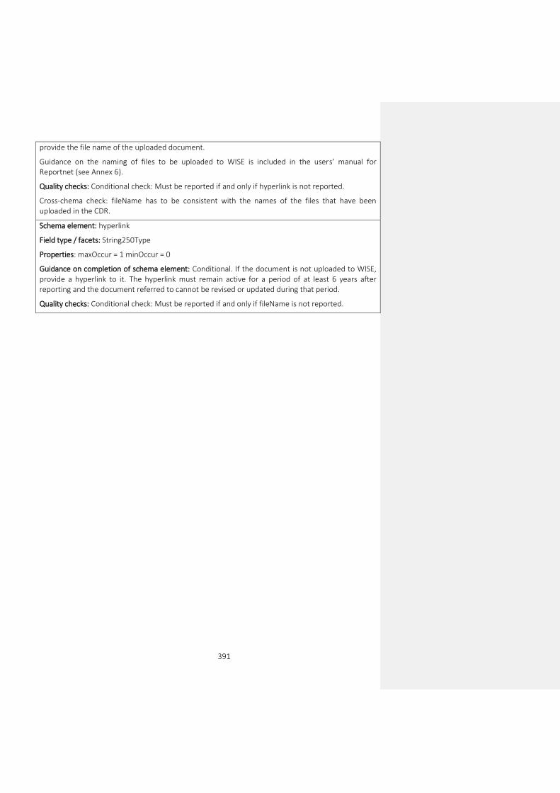
391
provide the file name of the uploaded document.
Guidance on the naming of files to be uploaded to WISE is included in the users’ manual for Reportnet (see Annex 6).
Quality checks: Conditional check: Must be reported if and only if hyperlink is not reported.
Cross-chema check: fileName has to be consistent with the names of the files that have been uploaded in the CDR.
Schema element: hyperlink
Field type / facets: String250Type
Properties: maxOccur = 1 minOccur = 0
Guidance on completion of schema element: Conditional. If the document is not uploaded to WISE, provide a hyperlink to it. The hyperlink must remain active for a period of at least 6 years after reporting and the document referred to cannot be revised or updated during that period.
Quality checks: Conditional check: Must be reported if and only if fileName is not reported.

392
Annex 10: UML Diagrams
All the diagrams can be found under the “reporting resources” page for the WFD 2022 reporting, at http://cdr.eionet.europa.eu/help/WFD/WFD_715_2022.