Embed Size (px)
Citation preview

What Do Students Need to Know For A Successful Career
Ann JohnsonAssociate [email protected]@kctcs.edu
Based upon work supported by the National Science Foundation grants DUE ATE
1304591, 1644409 and 1700496. Any opinions, findings, and conclusions or
recommendations expressed in this material are those of the author(s) and do not
necessarily reflect the views of the National Science Foundation.
Empowering Colleges:
Growing the Workforce

Can we identify the geospatial skills and competencies needed by students to successfully enter the geospatial technology workforce?
Can we create courses and programs to focus on those identified needs?
First lets look at the entire geospatial technology user community and the domain of their knowledge!

1,000,000
100
1,000
10
10,000
1
Ratio
What are the Domain Knowledge Needs?
All Users
Inc
rea
sin
gG
eo
sp
ati
al
Kn
ow
led
ge
1,000,000
100
1,000
10
10,000
1
Viewers /Virtual Users
Casual or Tool User
Technician
Specialist
Analyst
GIScientist
Ratio
Skills and Competencies:
What each level needs to know or do
What are the resources available to fill in the right triangle?
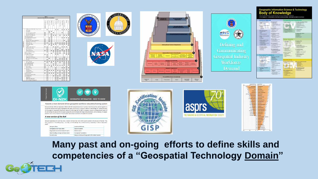
Many past and on-going efforts to define skills and
competencies of a “Geospatial Technology Domain”

U.S. Dept of Labor Geospatial Technology Competency Model
• Industry defined competencies
• Building Block Tiers:• Personal• Academic• Workplace• Industry Wide• Industry
• Each block “links to full” description
• Updated in 2014 and in process of updating in 2018• Out for Public comment soon!
http://www.careeronestop.org

Domain, Core and Occupation Competencies
Occupation Title or Level of Use
Inc
rea
sin
g G
eo
sp
ati
al
Kn
ow
led
ge
1,000,000
100
1,000
10
10,000
1
Viewers /Virtual Users
Casual or Tool User
Technician
Specialist
Analyst
GIScientist
Ratio
Ann Johnson June 2018

Entry Level Competencies
Occupation Title or Level of Use
Inc
rea
sin
g G
eo
sp
ati
al
Kn
ow
led
ge
1,000,000
100
1,000
10
10,000
1
Viewers /Virtual Users
Casual or Tool User
Technician
Specialist
Analyst
GIScientist
Ratio
Ann Johnson June 2018

• Panels of expert workers are used to precisely describe & define job tasks
+ knowledge, skills, behaviors, tools, equipment
• 8 to 12 GIS Technicians, over two - 8 hour days
Finding the Entry Level Competencies: GeoTech Center “DACUM” Job Analysis
DACUM: Developing A CurriculUM used regionally for competency based education & training by industry, government & education

DutiesTasks

Meta-DACUM MethodologyBy consolidating validated results from multiple DACUM analyses for a single occupation taken at various USA locations, we can identify a comprehensive list of competencies.

Program Content Tool – 311 Competencies

GeoTech Center Model Course Content• Geo 100 – Awareness Stand alone Model Course
• “Model Courses & Certificate”
• GST 101 – Introduction to Geospatial Technology
• GST 102 – Spatial Analysis
• GST 103 – Data Acquisition and Management
• GST 104 – Cartographic Design and Visualization
• GST 105 – Introduction to Remote Sensing
• GST 106 – Introduction to Geospatial Programming
• GST 107 – Geospatial Web Application and
Development
• GST 108 – Capstone
• GST 109 – Internship
• GST 201 - Crime Analysis

Additional Curriculum Resources
• Concept Module Videos • Map projections, Datums, Statistics, Data Management
• Demonstration Videos• How to carry our specific tasks
• MOOC – Introductory Course
• Meta-DACUM
• Program Content Tool and Program Assessment Tool
• Starting a Geospatial Program

Geotechcenter.org

Thank You!
Questions?
Ann Johnson
GeoTech Center
Associate Director