Embed Size (px)
Citation preview

MEETS THE RARITAN
WHERE THE GREEN BROOK

2 Where the Green Brook meets the Raritan
© U.S. Army Corps of Engineers, 2012
About Authors and Credits: This booklet was produced by the New York District of the U.S. Army Corps of Engineers in partial mitigation of the effects of the Green Brook Flood Damage Reduction Project on historic and cultural resources. The booklet was designed and written by Richard Hunter, Marjan Os-man and Charles Ashton of Hunter Research, Inc. under the overall direction of Lynn Rakos, Archaeologist, New York District, U.S. Army Corps of Engineers. Margo Reyes provided English-to-Spanish translation.
The assistance of the following individuals is gratefully acknowledged: John O’Connor and Frank Verga, Project Managers, New York District, U.S. Army Corps of Engineers; Charles Defendorf, Project Manager, Office of Engineering and Construction, New Jersey Department of Environmental Protection; Daniel Saunders, Acting Administrator and Deputy State Historic Preservation Officer, Andrea Tingey and Deborah Fimbel, Principal Historic Preservation Specialists, and Michelle Hughes, Senior Historic Preservation Specialist, New Jersey Historic Preservation Office, New Jersey Department of Environmen-tal Protection; Tom D’Amico, Historic Sites Coordinator, Somerset County Cultural and Heritage Commission; Damon Tvaryanas and Michael Murphy, Hunter Research, Inc.; Jennifer Leynes, Richard Grubb and Associates Inc.; Hannah Kerwin, Bound Brook Memorial Library; and Jessie Havens.
Printed by: Production Press, Inc., Jacksonville, Illinois
Fowler, T.M., Bound Brook and Bloomington [detail]. 1887.

Where the Green Brook meets the Raritan 3
Table of Contents
Summit
Plainfield
South Plainfield
Metuchen
Middlesex
New Brunswick
BoundBrook
U n i o n C o .
M i d d l e s e x C o .
F i rs t W
a t c h u n g Mo u n t a i n
Un i o n C
o .
Som
e r s e t Co .
So
me
r se
t Co
.M
i dd
l es
ex
Co
.
S e c o n d W a t c h u n g M o u n t a i n
The Green Brookin Central New Jersey
0 4 Miles
G r e e n B r o o k
B o u n d B r o o k
Ra r i t a n
R i v e r
Mi d d l e B
r o o k
Mi l
l st o
n e
R i v e r R a r i t a n R i v e r
Introduction ................. 4
Geography .................. 6
Prehistory .................... 8
Colonial .......................10
Revolutionary War ...... 14 The Industrial Era ........18
Twentieth Century........24
Twenty-First Century ...28
O
New Jersey

4 Where the Green Brook meets the Raritan
through this area, water still fundamentally defines ev-
eryday life and the landscape.
On occasion, the Raritan and its tributaries overtop
their banks, and floodwaters leave lives and property
in disarray. Flooding in the Green Brook sub-basin has
probably been a fact of life for centuries because of its
geology and topography, but it has been worsened in
the past century or so by the loss of wetlands, which
absorb floodwaters, and by the paving of roads, side-
walks and parking lots, and the construction of build-
ings. All of these reduce the amount of ground surface
available to absorb precipitation; instead of soaking
into the ground, rain runs off into streams and ultimate-
ly into the Raritan. Along the way, the flow is redirected
and impeded by bridge abutments and piers and other
man-made structures such as railroad embankments.
Over the past two centuries the worst flooding has usu-
Water looms large in the history of Bound Brook, a long
established community on the banks of the Raritan
River close to the mouth of the Green Brook. In ear-
lier years the Raritan carried shallow-draft vessels and
yielded rich hauls of fish. Then the Delaware and Rari-
tan Canal siphoned off most river traffic, spurring the
growth of South Bound Brook. Today, just a few small
boats ply this section of the Raritan – a fisherman in a
dinghy perhaps, a lone pleasure boater curious about
the river. Yet, for local residents and people passing
IntroductionWater, Water, Everywhere
Historic postcard of the Green Brook in Bound Brook.

Where the Green Brook meets the Raritan 5
ally been in Bound Brook, due to its location in the Rar-
itan River’s floodplain sandwiched between the Green
Brook and Middle Brook. Bound Brook has endured 16
serious floods since 1810. In recent years, devastat-
ing floods occurred twice in 1955, in 1971 and again in
1973. Hurricane Floyd in 1999 and Hurricane Irene in
2011 brought record floods, nearly matched by those
caused by nameless nor’easters in 2007 and in March
of 2010.
In response, the U.S. Army Corps of Engineers, in part-
nership with the New Jersey Department of Environmen-
tal Protection, Office of Engineering and Construction,
is building the Green Brook Flood Damage Reduction
Project, a system of levees, flood walls, pump stations
and retention basins throughout the Green Brook ba-
sin. The work is designed to protect Bound Brook and
surrounding communities from the so-called 150-year
flood, the height of water that would be expected to oc-
cur once in 150 years.
This booklet explores the area around Bound Brook and
vicinity, the heart of the flood damage reduction proj-
ect, from prehistoric times to the present. The region is
rich in history, including a role in the American Revolu-
tion, the transportation revolution of the 19th century,
and 20th- and 21st-century modernization and rebirth.
Water runs through each episode of this history: on
the one hand a sustaining force – a source of food, a
means of transportation, and a generator of power for
industry; on the other a more threatening prospect – an
obstacle in the landscape and a source of inundation in
times of heavy weather.
A fire rescue vessel in operation in the aftermath of the flooding brought about by Hurricane Floyd in Bound Brook in September 1999. [Source: New York District, U.S. Army Corps of Engineers].

6 Where the Green Brook meets the Raritan
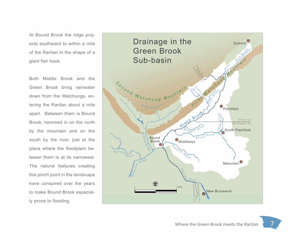
The Green Brook sub-basin extends across parts of
Union, Somerset and Middlesex Counties, generally
trending southwest from Summit through Plainfield,
and west from Metuchen and South Plainfield, to Bound
Brook. This is where the Green Brook, fed by tributar-
ies such as Bonygutt Brook, Bound Brook and Ambrose
Brook, empties into the Raritan River, just downstream
from the mouth of Middle Brook.
GeographyA River Runs Through It
Raritan River[several derivations, chiefly “stream overflows,” “forked river” and a variant of the sub-tribe “Naraticong”]Middle Brook
[unknown; perhaps because joins the Raritan midwaybetween the Green Brook the Millstone River]
Millstone River[allusion to mills on river]
Crab Brook[allusion to freshwater crabs in stream]
Cedar Brook[allusion to vegetation along stream]
Green Brook[color of water]
Stony Brook[character of stream]
Ambrose Brook[name of local colonial landowning family]
Bonygutt Brook[unknown; perhaps a reference to quality of fish in river]
Bound Brook[either “Bownd” name of colonial landowning family or derived from “boundary” in early deed]
Blue Brook[unknown; perhaps from Watchung Hills being known early on as Blue Hills]
What’s in a River’s Name?
Raritan River[several derivations, chiefly “stream overflows,” “forked river” and a variant of the sub-tribe “Naraticong”]
Middle Brook[unknown; perhaps because joins the Raritan midwaybetween the Green Brook the Millstone River]
Millstone River[allusion to mills on river]
Crab Brook[allusion to freshwater crabs in stream]
Cedar Brook[allusion to vegetation along stream]
Green Brook[color of water]Stony Brook
[character of stream]
Ambrose Brook[name of local colonial landowning family]
Bonygutt Brook[unknown; perhaps a reference to quality of fish in river]
Bound Brook[either “Bownd” name of colonial landowning family or derived from “boundary” in early deed]
Blue Brook[unknown; perhaps from Watchung Hills being known early on as Blue Hills]
What’s in a River’s Name?
The Raritan gathers water from the Piedmont and
Highlands in central and northern New Jersey before
flowing east past New Brunswick into Raritan Bay and
the Atlantic Ocean. Between Bound Brook and South
Bound Brook the river flows around the northern apex
of a great right-hand curve. To the north of the river the
long basalt ridge of the First Watchung Mountain rises
up steeply nearly 400 feet higher than the floodplain.
Where the Green Brook meets the Raritan 7
Summit
Plainfield
South Plainfield
Metuchen
Middlesex
New Brunswick
BoundBrook
U n i o n C o .
M i d d l e s e x C o .
F i rs t W
a t c h u n g Mo u n t a i n
Un i o n C
o .
Som
e r s e t Co .
So
me
r se
t Co
.M
i dd
l es
ex
Co
.
S e c o n d W a t c h u n g M o u n t a i n
B l ue B
r oo k
S t o n y
B r o o k
B o n y g u t t B r o o k
A m b r o s e B r o o k
Cr a
b Br o
o kC e d
ar B
rook
Drainage in the Green Brook Sub-basin
0 4 Miles
G r e e n B r o o k
B o u n d B r o o k
Ra r i t a n
R i v e r
Mi d d l e B
r o o k
Mi l
l st o
n e
R i v e r R a r i t a n R i v e r
At Bound Brook the ridge proj-
ects southward to within a mile
of the Raritan in the shape of a
giant fish hook.
Both Middle Brook and the
Green Brook bring rainwater
down from the Watchungs, en-
tering the Raritan about a mile
apart. Between them is Bound
Brook, hemmed in on the north
by the mountain and on the
south by the river, just at the
place where the floodplain be-
tween them is at its narrowest.
The natural features creating
this pinch point in the landscape
have conspired over the years
to make Bound Brook especial-
ly prone to flooding.

8 Where the Green Brook meets the Raritan
the Delaware or Lenape Indians who would have spo-
ken a dialect of the Eastern Algonquian languages.
Elevated, well-drained ground near perennial streams
and marshes was favored for camp sites, and several
of these were discovered along the Green Brook valley
early in the 20th century by avocational archaeologists
as the area became suburbanized. These sites were
probably used seasonally as bases for fishing and hunt-
ing and the processing of food resources. Anthropolo-
gist Leslie Spier (1893-1961), famous for his work in
the Southwestern United States, compiled information
about many of these sites early on in his professional
career when he was in his early 20s.
In the Middle Atlantic region Native Americans’ annual
food gathering patterns typically took them to the At-
lantic shore and its back bays in summer, then inland
The confluence of the Green Brook and the Raritan
River was undoubtedly well known to the region’s Na-
tive American inhabitants for centuries, even millennia,
before the arrival of Europeans. Around the time of Eu-
ropean contact in the 17th century this area and the lo-
cal inhabitants were referred to as “Sacunk,” meaning
“stream outlet.” The Sacunk people were a subset of
PrehistorySacunk Land
Projectile point styles typically found in the Green Brook valley. Left to right: argillite; jasper; quartz; chert.

Where the Green Brook meets the Raritan 9
B l ue B
r oo k
S t o n y
B r o o k
B o n y g u t t B r o o k
A m b r o s e B r o o k
Cr a
b Br o
o k
Ra r i t a n
R i v e r
C e dar
Bro
ok
B o u n d B r o o k
Mi d d l e B r o o k
R a r i t a n R i v e r
Mi l
l st o
n e
R i v e r
Summit
Plainfield
South Plainfield
Middlesex
New Brunswick
BoundBrook
U n i o n C o .
M i d d l e s e x C o .
F i rs t W
a t c h u n g Mo u n t a i n
Un i o n C
o .
Som
e r s e t Co .
So
me
r se
t Co
.M
i dd
l es
ex
Co
.
S e c o n d W a t c h u n g M o u n t a i n
G r e e n Br o
o k
Metuchen
Native Americans in the Green Brook Valley
0 4 Miles
S A C U N K Dism
al Swam
p
Zone of Native American Occupation
Camp Site
Burial Site
Swamps
Trails/Line of Native American Movement
for the winter. These trips made use
of ancient trails, which not surprisingly,
tended to avoid obstacles (such as steep
hills, swamps and impassable streams)
whenever possible. Thus, many of these
favorable routes ran parallel to the larger
water courses, and were later improved
by Europeans to become roads; many are
still in use today. One such trail became
the “Old Raritan Road” from Elizabeth-
town to Bound Brook; today its route is
traced intermittently by secondary roads
from South Plainfield to Main Street in
Bound Brook. Another was the Sacunk-
Lopatcong trail on the north bank of the
Raritan that passed through the Bound
Brook area on portions of today’s River
Road on its way to Phillipsburg on the
Delaware River.

10 Where the Green Brook meets the Raritan
European settlement around what is now Bound Brook
began in the early 1680s. The land on the north bank
of the Raritan between the Green Brook and Middle
Brook was purchased by the East Jersey Proprietors in
1681, one of whom, Thomas Codrington, a prominent
New York City merchant, settled here in 1683. Oth-
ers settlers soon followed. The pioneering European
settlers were mostly farmers of Dutch descent, moving
west from Long Island, or of English and Scottish lin-
eage, relocating from New England.
Although there were nucleated settlements such as the
twin villages of Bound Brook and Middle Brook, both lo-
cated on the north side of the Raritan River close to the
two streams for which they were named, these were
the exception during the colonial period. Most resi-
dents lived on widely dispersed, self-sufficient farms
that generated a small surplus of agricultural goods for
ColonialFarmscape on the Floodplain
John Hills, A Sketch of the Northern Parts of New Jersey. 1781. The Green Brook flows from north to south along the base of the First Watchung ridge entering the Raritan just to the east of Bound Brook.

Where the Green Brook meets the Raritan 11
the mouth of the Green Brook, and became part of the
road on the north bank of the Raritan. One of these
spans survives on Railroad Avenue, today all but bur-
ied by later land-shaping activities and more resem-
bling a retaining wall than a bridge.
There was no road connection across the Raritan until
1761-62, when the original Queen’s Bridge was built.
Although this bridge crossed the Raritan, it did not lead
to South Bound Brook, as that place did not yet exist.
South of the Raritan was rural Franklin Township.
sale in local and regional markets. The earliest land
divisions along the river were in the form of long, nar-
row lots, each with river frontage.
While the Raritan was navigable by shallow draft ves-
sels at the mouth of the Green Brook, the principal land
route was the “Road up Raritan” from Piscataway to
Bound Brook, along the north bank of the river. This
was originally an Indian trail. The road that took over
its route was formally laid out in 1684. By 1760, two
stone bridges joined by a causeway were built across
The Old Stone Arch Bridge on Railroad Avenue at the mouth of the Green Brook. Left: an early 20th-century view when much of the bridge was still visible [Source: Emogene Van Sickle, The Old York Road, 1936, p. 81]; Center and right: views when the bridge was excavated in 2007 [Source: Richard Grubb & As-sociates, Inc. 2007].

12 Where the Green Brook meets the Raritan
Colonial industry was locally-based and most often
took the form of gristmills or sawmills. The Queen’s
Bridge in fact provided access for Franklin Township’s
farmers to Field’s gristmill, near the eastern end of the
causeway at the Green Brook; one of the stone bridges
spanned its tail race. This key crossing and the mill
undoubtedly contributed to the growth of the nearby
village of Bound Brook.
The Field gristmill stood on the east bank of the Green
Brook, near its mouth; the brook supplied the power to
turn its stones which ground wheat, oats, barley, corn
and other grains into flour and meal. Although no trace
is visible on the ground today, historic maps show it
as early as 1766, and in all likelihood it was in exis-
tence when the causeway and two stone bridges were
built sometime before 1760 since one bridge spanned
its raceway. The mill was probably built by Jeremiah
Field (1713-1778) who inherited the property from his
father, also named Jeremiah, at the latter’s death in
Benjamin Morgan, A Plan of Somerset County in the Province of East Jersey. 1766. This map shows the principal roads, farms and houses in the Bound Brook vicinity as well as the Field gristmill at the mouth of the Green Brook.
1747. The Field family had come from England in 1638
with Roger Williams and settled in Rhode Island. They
moved to Flushing, New York and then to Bound Brook,
sometime before 1729.

Where the Green Brook meets the Raritan 13
Field’s Mill may have looked much like this frame gristmill building in Ringoes, New Jersey [Source: Historic American Buildings Survey, NJ-451, 1937-38].
Field’s Mill
To Brunswick
Amrose’s Brook
John Ross
John Hitchins
To Linc
oln’s G
ap
Bound B
rook Town
Bound B
rook
Amrose’s Brook
Simeon DeWitt, Contraction in the Jerseys [redrawn from Erskine-Dewitt Series No. 74a]. 1780. This route map, prepared for the Continental Army, shows the main road heading northeast out of Bound Brook across the mouth of the Green Brook and past the Field mill (indicated by asterisk). The course of the Green Brook is named here as Bound Brook.
During the Revolutionary War the Field mill was an im-
portant source of flour for the Continental Army camped
nearby, and was a tempting target for British foraging
parties. The mill survived the war and continued to op-
erate until after the Civil War. It burned down around
1880.

14 Where the Green Brook meets the Raritan
Bound Brook, because of its location at the foot of
the First Watching Mountain, and the presence of the
Queen’s Bridge over the Raritan, and the Field mill at
the eastern edge of the village, took on great military
importance during the Revolutionary War. This was
particularly the case in early 1777 as military opera-
tions focused on New York and Philadelphia, and cen-
tral New Jersey became the “Crossroads of the Rev-
olution.” Eventually hostilities would come to Bound
Brook itself.
Less than a year into the war, the spring of 1777 was
a time of considerable tension and uncertainty for both
the British and American armies contending for control
of the Philadelphia-New York corridor. After the surprise
American victories at Trenton and Princeton shortly af-
ter Christmas of 1776, the British had retreated to New
York and the towns of northeastern New Jersey, includ-
Revolutionary WarSkirmish and Camp
Johann Von Ewald, Plan von der Gegend von Paunbruck d. 20 Aprill 1777. 1777. This schematic map, drawn for the Hessian commander Captain von Ewald following the Battle of Bound Brook, shows the main rivers, roads, houses and fortifications in and around the village of Bound Brook.

Where the Green Brook meets the Raritan 15
left New Brunswick intent on taking American-held Bound
Brook by surprise. A poorly coordinated multi-pronged as-
sault at daybreak saw the Americans pushed out of the
battery by British and Hessian forces advancing over the
Green Brook crossing and the Queen’s Bridge, while an-
ing Perth Amboy and New Brunswick on the Raritan.
Washington’s forces had entrenched for the rest of the
winter in the Morristown area. The intervening terri-
tory of central New Jersey constituted a semi-milita-
rized zone where local sympathies constantly shifted
between patriot and Loyalist. American and British
forces vied for control not only of the many small towns
and villages ranged across the countryside, but also of
transportation routes, mills, food and livestock.
Within this context, Bound Brook’s role in the war becomes
clearer, explaining why it appears on several military
maps drawn while the war was in progress. In early 1777
there was an American outpost in Bound Brook under the
command of Major General Benjamin Lincoln that was fo-
cused on the so-called Half Moon Battery at the eastern
edge of the village, defending both the Queen’s Bridge
and the crossing of the Green Brook at Field’s mill. During
the night of April 12/13, 1777, a 4,000-strong British and
Hessian force led by Major General Charles Cornwallis
Left: Captain Johann von Ewald (1744-1813), Hessian commander at the Battle of Bound Brook, April 12, 1777 [portrait by unknown artist, circa 1800]. Right: Major General Benjamin Lincoln (1733-1810), commander of American troops in Bound Brook in April 1777 [portrait by Charles Willson Peale, 1784, Independence National Historical Park].

16 Where the Green Brook meets the Raritan
other contingent of British troops under Cornwallis moved
on Lincoln’s headquarters in the Van Horne house to the
west of the village. However, Lincoln and most of the 500
or so American soldiers under his command managed
to escape into the surrounding hills. This left the village
open to the depredations of Cornwallis’s troops, who later
that day returned to New Brunswick with an assortment of
prisoners, artillery and stores. This action, the only major
military engagement in the area during the Revolutionary
War, became known as the Battle of Bound Brook.
The following month, May of 1777, Washington shifted
the main body of the Continental Army southward from
Morristown. Most of the army was consolidated into en-
campments along the East and West branches of Middle
Brook in the protected valley between the First and Sec-
ond Watchung Mountains, a naturally defensible position
above Bound Brook. Furthermore, the First Watchung
ridge provided an excellent view of the Raritan and Mill-
stone valleys, enabling the Americans to monitor British
movements along the New Brunswick-Princeton corridor.
For their part, the British wanted to lure a large Ameri-
can force out of their encampments in the Somerset
hills and into a full-fledged battle in the lowlands, where
both sides knew the British would likely prevail. On
June 14, Cornwallis led a British and Hessian force of
some 10,000 troops out from New Brunswick, head-
ing toward Princeton before turning north and mak-
ing camp in the Lower Millstone Valley. For five days
Cornwallis lay in wait for the Americans to come down
from the hills, but Washington was not to be tempted.
On June 19, the British and Hessian troops returned to
New Brunswick and over the following days continued
to withdraw to Perth Amboy and Staten Island. At this
juncture, American troops began to venture out from
their mountain stronghold and harass the outlying ele-
ments of the British and Hessian force. An inconclu-
sive battle took place at Short Hills on June 26 before
Cornwallis’s army reached the safety of Staten Island
by the end of the month.
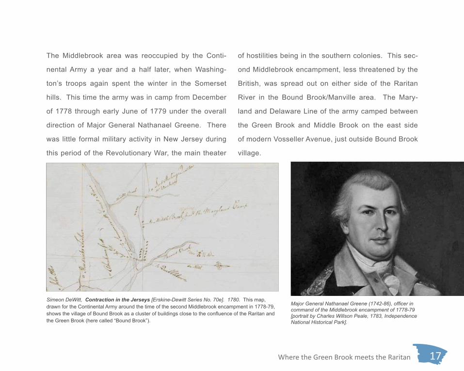
Where the Green Brook meets the Raritan 17
of hostilities being in the southern colonies. This sec-
ond Middlebrook encampment, less threatened by the
British, was spread out on either side of the Raritan
River in the Bound Brook/Manville area. The Mary-
land and Delaware Line of the army camped between
the Green Brook and Middle Brook on the east side
of modern Vosseller Avenue, just outside Bound Brook
village.
The Middlebrook area was reoccupied by the Conti-
nental Army a year and a half later, when Washing-
ton’s troops again spent the winter in the Somerset
hills. This time the army was in camp from December
of 1778 through early June of 1779 under the overall
direction of Major General Nathanael Greene. There
was little formal military activity in New Jersey during
this period of the Revolutionary War, the main theater
Simeon DeWitt, Contraction in the Jerseys [Erskine-Dewitt Series No. 70e]. 1780. This map, drawn for the Continental Army around the time of the second Middlebrook encampment in 1778-79, shows the village of Bound Brook as a cluster of buildings close to the confluence of the Raritan and the Green Brook (here called “Bound Brook”).
Major General Nathanael Greene (1742-86), officer in command of the Middlebrook encampment of 1778-79 [portrait by Charles Willson Peale, 1783, Independence National Historical Park].
18 Where the Green Brook meets the Raritan
In 1809, communication with the outside world was en-
hanced by the opening of the Jersey Turnpike, later
called the Easton Turnpike, a road that ran from the
Easton Bridge at Phillipsburg to New Brunswick, link-
ing the Delaware and Raritan Rivers. Passing through
Bound Brook and South Bound Brook via the Queen’s
Bridge, today it is known as Main Street in both com-
munities; it was still called the Easton Turnpike as late
as World War I. Turnpikes in the 19th century were built
and maintained by private companies who had the right
to charge tolls to recoup construction and maintenance
costs and pay dividends to their investors. Eventu-
ally the turnpikes were taken over and became public
roads. Turnpikes generally connected major commer-
cial and manufacturing centers, unlike the local roads
they supplemented.
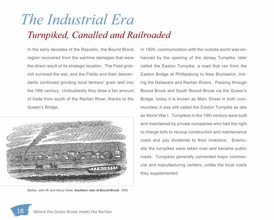
In the early decades of the Republic, the Bound Brook
region recovered from the wartime damages that were
the direct result of its strategic location. The Field grist-
mill survived the war, and the Fields and their descen-
dants continued grinding local farmers’ grain well into
the 19th century. Undoubtedly they drew a fair amount
of trade from south of the Raritan River, thanks to the
Queen’s Bridge.
The Industrial EraTurnpiked, Canalled and Railroaded
Barber, John W. and Henry Howe, Southern view of Bound Brook. 1845.

Where the Green Brook meets the Raritan 19
The turnpike, though, was only a hint of transporta-
tion-related changes that the next few decades would
bring. In the 1830s, two new (and competing) modes
of transportation arrived that began a transformation of
the Bound Brook area that would continue for another
century.
In the early 1830s the Delaware and Raritan Canal was
dug across central New Jersey, fulfilling a decades-old
vision of providing a water route connecting the two riv-
ers of the same names, providing a shorter and safer
passage between Philadelphia and New York than the
longer coastal route. The 44-mile main line of the ca-
nal was supplied with water from the Delaware River by
a 22-mile feeder which ran from Raven Rock to Tren-
ton, the high point on the main canal. From Trenton
the main canal followed a flat route past Princeton to
Kingston where it continued north along the right bank
of the Millstone River. Where the Millstone joins the
Raritan River near Manville the canal runs along the Beers, F.W. Bound Brook and Bloomington. Atlas of Somerset County. 1873.

20 Where the Green Brook meets the Raritan
Besides Trenton and New Brunswick, the canal also
served towns along its route, some of which did not
even exist before the canal arrived. South Bound
Brook was just such a town. There were two basins
near the Queen’s Bridge, the perfect location for busi-
nesses such as coal dealers, lumber yards, sawmills
and grain dealers. The new town grew rapidly, acquir-
ing its name along the way (although from 1869 to 1891
the community was known as Bloomington).
But still more change was coming. In 1830 the New
Jersey Legislature chartered the Elizabethtown and
Somerville Railroad. Construction began at the east-
ern end in 1834, and the tracks reached Bound Brook
in 1840, Somerville a year later. In 1849, after a bank-
ruptcy and reorganization, the line merged with the
Somerville and Easton Railroad to form the Central Rail-
road of New Jersey. By 1852, Bound Brook enjoyed rail
service to Phillipsburg and Elizabeth and all intermedi-
ate points. In 1860 service was extended to Jersey City.
Today, this is New Jersey Transit’s Raritan Valley line.
right bank of the Raritan River, opposite Bound Brook,
to New Brunswick. Beginning with the completion of
the canal in 1834, canal boats brought coal and raw
materials to, and carried finished goods from, indus-
tries at Trenton and New Brunswick. At its peak, after
the Civil War, canal boats carried 2.8 million tons of
freight in a single year (despite the annual winter shut-
down due to freezing), 83% of it coal.
Fowler, T.M. Bound Brook and Bloomington. 1887. This bird’s eye view, from the southeast, shows the town of Bound Brook at the upper center, Bloomington (South Bound Brook) at the left and the mouth of the Green Brook at the lower right.

Where the Green Brook meets the Raritan 21
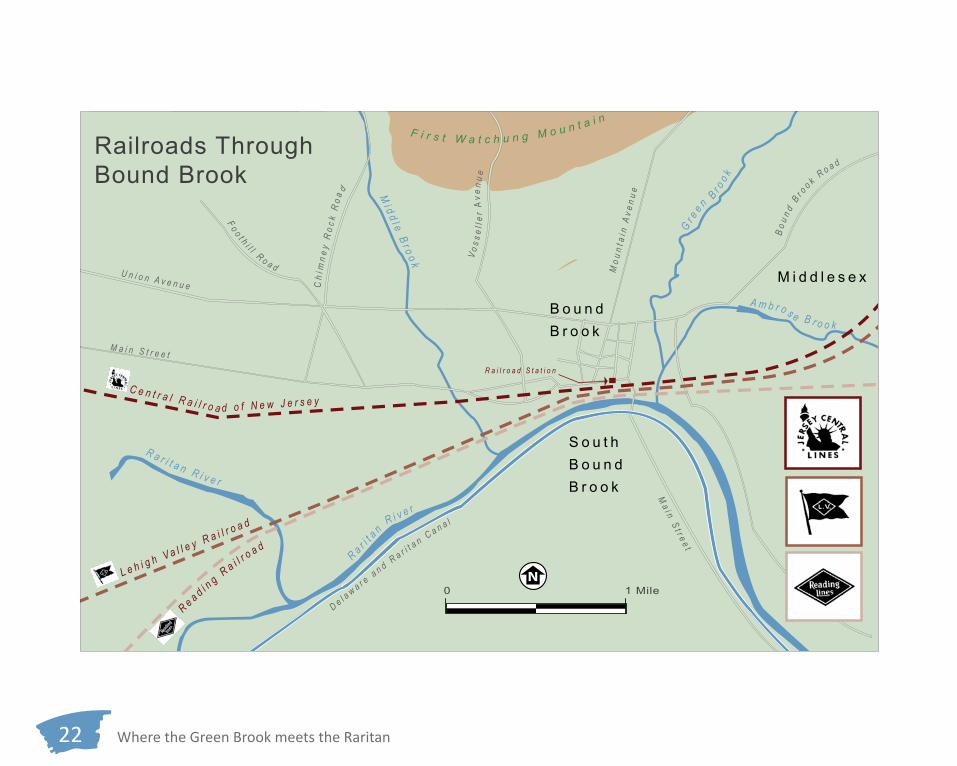
The new railroad passed between the First Watchung
Mountain and the Raritan River, running parallel and
north of the old road that crossed the Green Brook and
the Field mill race on the two stone bridges and con-
necting causeway. The railroad company built an em-
bankment to carry its tracks across the end of Field’s
millpond, drastically altering the natural drainage in the
vicinity of the mill.
In 1875 the tracks of the Easton and Amboy (later the
Lehigh Valley) Railroad were laid through Bound Brook,
also on the north bank of the river, on another embank-
ment between the Central Railroad of New Jersey’s
tracks and the old road. The dam creating the mill-
pond for Field’s mill was raised 18 inches so the pond
could be used as a source of water for the steam lo-
comotives, but the result was a 60-acre stagnant pool.
After outbreaks of malaria in 1878 and 1880, lawsuits
forced the railroad to remove the dam and reroute the
main channel of the Green Brook to its present location. Postcard view of Bound Brook railroad station. Circa 1920.
A photograph taken in 1866 of The Tycoon, a locomotive in use on the Cen-tral Railroad of New Jersey [www.northeast.railfan.net].
22 Where the Green Brook meets the Raritan
U n i o n A v e n u e
M a i n S t r e e t
Mo u
n ta i
n A
v en u
e
V os s
e ll e
r A
ven u
e
Bo u
n d B
r oo k R
o a d
Ma i n S t r e e t
Ch i
mn e
y R
o ck
Ro a
d
F o o t h i l l R o a d
R a r i ta n R i v e r
Mi d d l e B r o o k
Gr e
e n B r oo k
A m b r o s e B r o o k
R a r i t a n R i v e r
L e h i g h V a l l e y R a i l r o a d
C e n t r a l R a i l r o a d o f N e w J e r s e y
R e a d i ng R
a i l ro a d
R a i l r o a d S t a t i o n
De l a w a r e a n d R a r i t a n C a n a l
New Brunswick
B o u n d B r o o k
M i d d l e s e x
S o u t hB o u n d B r o o k
F i r s t W a t c h u n g M o u n t a i n
Railroads Through Bound Brook
0 1 Mile

Where the Green Brook meets the Raritan 23
A new kingpost truss bridge carried the old road over
the new channel. This bridge was replaced by an iron
truss bridge in 1894, possibly in conjunction with the
establishment of trolley service between Raritan and
New Brunswick that utilized this route.
Bound Brook’s third railroad was built in 1892. The
Port Reading Railroad was the creation, as its name
suggests, of the Reading Railroad. Originating in
Bound Brook, it branched off the Reading’s main line
and went only as far as Port Reading on the banks of
the Arthur Kill in Woodbridge, New Jersey, giving the
Reading Railroad valuable access to New York harbor.
In Bound Brook, like the other two railroads it traversed
the relatively flat land north of the Raritan, but this time
to the south of the stone bridge and the new kingpost
bridge. Also, like its two neighbors, it crossed the low
ground at the mouth of the Green Brook on an embank-
ment. A steel girder bridge carried it over the brook
proper.
As the 19th century closed, the vicinity of the Green
Brook-Raritan River confluence was vastly different
from what it had been a century earlier—a canal and
three railroads had brought prosperity, industry and
new residents, even a new town south of the river. The
old Field mill was gone as the result of a fire about
1880. Even the brook itself had been rerouted, a shift
in alignment that led to much subsequent confusion
about the position of the boundaries between Somer-
set and Middlesex counties and the boroughs of Bound
Brook and Middlesex.
Queen’s Bridge
Old Stone Arch Bridge Field’s Mill
Somerset Co. Middlesex Co.
Deed Map of 1881 [Somerset County Clerk’s Office, Somerville, New Jersey]. This map shows some of the radical land alteration at the mouth of the Green Brook caused by late 19th-century railroad construction.

24 Where the Green Brook meets the Raritan
Twentieth CenturyMore Roads, More RailsIn the 20th century, cars and trucks began to replace
canal boats, trains and trolleys as movers of people
and freight, slowly at first and then faster as the new
century matured. Water still played an important role,
though: at the turn of the century the Delaware and
Raritan Canal was still in business, although it had not
turned a profit since 1892 and service gradually dete-
riorated. The canal died a slow death, but was res-
urrected later in the century. By 1931, annual freight
tonnage had declined to 41,800 tons. After the canal
shut down for the winter at the end of 1932 it did not
reopen. In 1934 the State of New Jersey took it over
to supply water to communities and industries along its
route, and in 1974 it was reborn as the Delaware and
Raritan Canal State Park.
There was change too in the crossings of the Raritan
River between Bound Brook and South Bound Brook.
In 1928 a rail spur was constructed linking the Ruberoid
Company plant in South Bound Brook to the Port Read-
ing Railroad. The spur crossed the Raritan on an im-
pressive, curved, 495-foot-long, six-segment, cross-
braced steel girder bridge supported by five concrete
piers. Ruberoid, a leading manufacturer of asbestos-
cement siding, occupied the former Standard Paint
Company factory and continued as a major employer
in the area until the 1970s when the health hazards
of asbestos exposure, and particularly the condition
known as mesothelioma, began to be fully appreciat-
ed. In 1984, the historic Queen’s Bridge, a triple-span,
through-truss steel structure, was replaced with a new
and wider concrete bridge that could support a heavier
traffic volume.
North of the Raritan River still more change occurred in
the local transportation network. Trolley service, using

Where the Green Brook meets the Raritan 25
Iron Truss Bridge
Ruberoid Company Port Reading Railroad Spur
Old Stone Arch Bridge
Queen’s Bridge
Central Railroad of New Jersey
Lehigh Valley Railroad
Reading Railroad
Delaware and Raritan C
anal
Raritan River
South Bound Brook
BoundBrook
Green Brook
Photograph of Bound Brook Showing the Mouth of Green Brook. 1932. [Courtesy of Bound Brook Memorial Library].

26 Where the Green Brook meets the Raritan
place, unused, until it was finally removed in 2004 as
part of the flood damage reduction project.
The transportation improvements helped to support
residential expansion throughout the Green Brook
drainage system over much of the 20th century. Post-
The Warren-through-truss bridge erected in 1894 to carry Railroad Avenue, formerly the Raritan Road, over the mouth of the Green Brook. [Source: Hunter Research, Inc. 2002].
the iron truss bridge across the mouth of the Green Brook,
ended in the late 1920s and road traffic shifted from the
18th-century route along the river to East Main Street/
Lincoln Boulevard, where a handsome new gateway
bridge over the Somerset/Middlesex County border was
built in 1932. The old 1894 iron truss bridge was left in

Where the Green Brook meets the Raritan 27
World War I and post-World War II saw rapid suburban
growth not only in Bound Brook, South Bound Brook
and Middlesex, but further upstream in Green Brook,
Dunellen and the Plainfields. Herein, with the substitu-
tion of buildings and impervious surfaces for absorbent
soil and woodland cover, grew the root of future flood-
ing problems in the Raritan floodplain.
Three views of the bridge erected in 1928 to carry a spur of the Port Read-ing Railroad over the Raritan River to the Ruberoid Company plant in South Bound Brook. This bridge was removed in 2007 as part of the flood damage reduction project. [Left and top, courtesy of Hunter Research, Inc. 2002; bot-tom right, showing demolition in progress, courtesy of Michael Breslin, for the New York District, U.S. Army Corps of Engineers 2007].
28 Where the Green Brook meets the Raritan
damage reduction project nearing completion the fu-
ture growth and economic health of the borough will be
greatly enhanced.
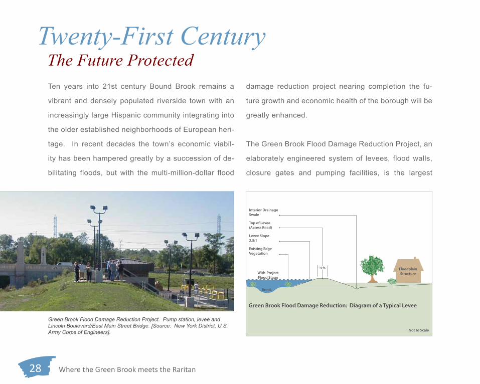
The Green Brook Flood Damage Reduction Project, an
elaborately engineered system of levees, flood walls,
closure gates and pumping facilities, is the largest
Ten years into 21st century Bound Brook remains a
vibrant and densely populated riverside town with an
increasingly large Hispanic community integrating into
the older established neighborhoods of European heri-
tage. In recent decades the town’s economic viabil-
ity has been hampered greatly by a succession of de-
bilitating floods, but with the multi-million-dollar flood
Twenty-First CenturyThe Future Protected
Existing Edge Vegetation
Brook
Green Brook Flood Damage Reduction: Diagram of a Typical Levee
Top of Levee(Access Road)
Levee Slope 2.5:1
Interior Drainage Swale
Not to Scale
FloodplainStructureWith-Project
Flood Stage
10 ft.
Green Brook Flood Damage Reduction Project. Pump station, levee and Lincoln Boulevard/East Main Street Bridge. [Source: New York District, U.S. Army Corps of Engineers].

Where the Green Brook meets the Raritan 29
federal-and-state collaboration on flood control in New
Jersey to date. Authorized in 1986, the initial phase of
the project, which will secure the especially flood prone
area at the confluences of the Green Brook and Middle
Brook with the Raritan, is slated for completion in 2013.
This project is but the most recent of many changes
over the centuries to the landscape where the Green
Brook meets the Raritan.
Green Brook Flood Damage Reduction Project. Top and bottom: the Lincoln Boulevard/East Main Street Bridge over the Green Brook before and after its reconstruction in 2002. [Source: New York District, U.S. Army Corps of Engineers].
For More Information:
Stratford, Dorothy A. and Margaret McKay. 2000 Images of America: Bound Brook. Arcadia Publishing, Charleston, SC, Chicago, IL, Portsmouth, NH, San Francisco, CA.
Green, Howard L.2009 Continuing the Mission: A History of the New York District 1975-2005. New York District, U.S. Army Corps of Engineers, New York, NY.
Bound Brook Memorial Library, 402 East High Street, Bound Brook.

A brief history of the confluence of the
GREEN BROOK and the RARITAN RIVER