Embed Size (px)
Citation preview
Bristol Docks Estate Wildlife Survey and Assessment
Final Report
20 December 2009
Phil Quinn MPEcology
Wildlife Survey and Assessment of the Bristol Docks Estate
Phil Quinn Ecology and Landuse MPEcology i
Contents
Executive Summary ...................................................................................... 1
1. Introduction ............................................................................................ 2
2. Methodology .......................................................................................... 3
3. Site description ...................................................................................... 5
4. Results and Assessment .................................................................... 13
5. Conclusions ......................................................................................... 33
6. Recommendations ............................................................................... 35
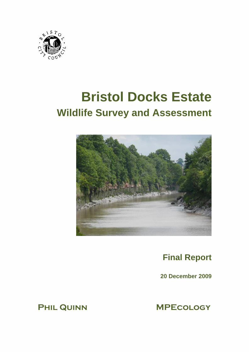
Appendix 1-8: Detailed Survey Results 61-94 Figure 1-6. Survey Areas. 7 Figure 7-12. Summary of Findings. 17 Figure 13-15. Species Maps (Appendix 8). 95 Cover photograph: View east along the New Cut This report has been produced for Bristol City Council by:
Phil Quinn (Ecology and Land use), 15 Osborne Road, Clifton, Bristol, BS8 2HB. E-mail: [email protected]
MP Ecology, 30 Tilnor Crescent, Norman Hill, Dursley, Gloucestershire, GL11 5RZ.E-mail: [email protected]
Bristol City Council Acknowledgement :
The provision of information by Bristol City Council does not imply a right to reproduce or commercially exploit such information without the Council's express prior written permission. Reproduction or commercial exploitation of information provided by the Council without its express permission may be an infringement of copyright.
The council is unable to grant permission to reproduce or re-use any material that is the property of third parties. Permission to reproduce or re-use such material must be obtained from the copyright holders.
Statement of the publication purpose:
“The Ordnance Survey mapping included within this publication is provided by Bristol City Council under license from the Ordnance Survey in order to fulfill its public function to make available Council held information regarding the Bristol City Docks – Habitat Survey and Management Plan. Persons viewing this mapping should contact Ordnance Survey copyright for advice where they wish to license Ordnance Survey mapping/map data for their own use.”
Wildlife Survey and Assessment of the Bristol Docks Estate
Phil Quinn Ecology and Land use MPEcology 1
Executive Summary Over the summer of 2009 a wildlife survey of the Bristol City Council (BCC) Docks Estate was undertaken.
Particular highlights of this survey have been the discovery that otters Lutra lutra are active within the city centre, and that there is the potential for this species to breed here as long as quality otter habitat is retained and, just as importantly, more is created for them.
The rich diversity and high biomass of fish, both freshwater and estuarine species, is a notable feature of the Floating Harbour and may come as a surprise to many people who live, work and relax in the city.
Over 400 species of vascular plant were recorded from the survey area, the majority native, but also many alien species. Some have a long history in the docks reflecting past mercantile activity, whilst others are recent colonists from the gardens of the houseboats which have partly replaced the commercial shipping. Many of the newest introductions are grass species, often introduced with bird seed.
Plants more commonly associated with the open countryside such as pyramidal orchid (Anacamptis pyramidalis), salad burnet (Sanguisorba minor) and quaking grass (Briza media) were recorded in highly urbanised locations along with other notable native species long associated with central Bristol such as ivy broomrape (Orobanche hederae).
The city centre, even those special wild areas that still exist there, is a hard place for many bird species to survive and correspondingly the number of breeding bird species recorded during the survey was relatively low. However, one of only two known breeding colonies of sand martin (Riparia riparia) in the former administrative district of Avon occurs within the docks estate. Cormorant (Phalacorax carbo) can be approached within a distance unimaginable on the coast, such that the piercing blue of their eyes can be seen even without binoculars. In addition, attractive grey wagtails (Motacilla cinerea) breed here along with mute swans, mallards (Anas platyrhynchos) and moorhens (Galinulla chlorops).
It is hoped such findings will help to identify wildlife enhancement opportunities within the docks estate as well as to steer management regimes. In addition, the opportunity exists to relay information to the public with the intention of galvanising interest and positive community feedback.
Wildlife Survey and Assessment of the Bristol Docks Estate
Phil Quinn Ecology and Land use MPEcology 2
1. Introduction Phil Quinn (Ecology and Land use) and Matt Pickard (MPEcology) were commissioned by Bristol City Council (BCC) to undertake field survey of the Docks Estate during the summer of 2009. The aim of the surveys was to assist the Council in its duties under the Natural Environment and Rural Communities Act (NERC) 2006, namely, regard for the conservation of biodiversity interest on land and buildings within its ownership. Primarily the survey was intended to inform the Council of the existing nature conservation value of the estate and in particular to identify:
• areas of high biodiversity value; • locations of rare or uncommon species; • areas where protected species may reasonably be presumed present; • opportunities for habitat enhancement and improved public enjoyment.
It is intended that the survey findings will lead to enhanced management of the estate by providing a comprehensive snapshot of the nature conservation value of every part of the Docks Estate, thereby informing its future planning and management decisions.
In particular the survey aims to identify areas where practical measures can be enacted to improve the nature conservation value of this integral part of the city centre. It is hoped that public involvement can build upon this report by renewing the focus on wildlife and encouraging the public to report sightings of all wildlife regardless of rarity value and thereby helping create an evolving record of the flow of nature through the heart of the city.
In addition to the reporting of survey findings via this document, data has been made available in an electronic format (including Geographical Information System (GIS)). This information includes a collection of over 900 digital photographs of habitats and species taken during the course of field survey visits. These images have been “hot-linked” into GIS so that their locations are recorded.
Wildlife Survey and Assessment of the Bristol Docks Estate
Phil Quinn Ecology and Land use MPEcology 3
2. Methodology
2.1. General Bristol City Council provided a map identifying the extent of the Docks Estate and this formed the basis of all survey activities.
Two highly practised field ecologists, with a combined total of forty years site and species survey experience, undertook the survey work in three phases:
1. An initial detailed walkover of the Docks Estate carried out over eight days between 3rd and 11th June 2009;
2. A boat-borne survey of dock walls and otherwise inaccessible areas on 15th June 2009;
3. A follow-up walkover survey of the Docks Estate on 27th July to identify any late-flowering species not identified earlier in the year.
Bristol Harbour staff made a craft available for the team to undertake the Floating Harbour and Feeder Canal boat-borne survey. The boat operative, Mr Miles Parker, was knowledgeable on many aspects of the history and management of the Floating Harbour and his knowledge contributed significantly to this report. This survey methodology enabled the identification of numerous plants, and other features including an otter sprainting site and a sand martin colony which could not be observed from the land.
An initial proposal to survey habitats associated with the New Cut by canoe was amended because land-based access and vantage points appeared to offer sufficient coverage. Instead, arrangements were made to allow a canoe-based survey under the City following the castle moat and lower levels of the River Frome (all underground). The aim of the proposed visit was to investigate use of this feature by protected species such as bats and otters. However, the logistics of arranging a suitable guide and access keys were too difficult and this phase of the survey was also abandoned.
2.2. Detailed Survey Methodology The Docks Estate was split into five units, largely based on existing BCC management areas (City Docks Mooring Policy, BCC 2008). Figure 1 presents the compartments (which are described fully in Chapter 4, Site Description) and otherwise defined as:
• Cumberland Basin (CB) • Water Activity Harbour (WAH) • Harbour Arena (HA) • Upper Reaches (UR) • New Cut (NC)
During each field visit, distinct sections of dock or riverside habitat were defined into plots and given unique reference codes. This enabled species lists and other descriptions to be assigned to each defined plot.
Wildlife Survey and Assessment of the Bristol Docks Estate
Phil Quinn Ecology and Land use MPEcology 4
All evidence of plants, birds, mammals, invertebrates and fish were recorded, with notes made on the status and activity levels of each:
Vascular plants - All plants encountered within a plot were recorded to species level where possible, although, several garden escape aliens were only assigned to genus or even family level. Voucher specimens of some plant species were made and a second opinion sought from external referees. An electronic record detailing all plant species observed during site visits was then created and stored in a Microsoft excel spreadsheet.
Birds – All bird species within the study area identified visually, or from calls, were recorded as incidental field notes.
Bats – Field evidence suggesting the potential presence of bats including holes, cracks and crevices which could be used as roost entrances; droppings, feeding remains, grease marks and urine stains was sought wherever suitable old structures, brickwork, masonry or trees were encountered. Both surveyors have extensive bat survey experience and any evidence or potential for bats was recorded.
Otters - Features likely to be utilised by otters such as prominent stonework, jetties, logs or the bases of steps were inspected to establish the presence or absence of spraints (droppings) or other field signs.
Water Voles - Habitat that appeared suitable for water voles was subject to detailed survey to establish the presence or absence of field signs such as latrines, feeding stations or burrows.
Fish - Where anglers were encountered during the survey, enquiry was made into the species of fish being caught and on occasion the surveyors could confirm accounts by examining the contents of keep-nets. In addition, BCC staff also provided the survey team with data describing dock catches made by members of Bristol Angling Club during 2009.
Invertebrates - Invertebrate records were limited to Odonata (dragonflies and damselflies) and Lepidoptera (butterflies and moths). In addition, areas that appeared to offer potentially suitable habitat for a broad diversity of invertebrates were also recorded.
Other features – In the event that a particular section or location was considered to offer potential for enhancement either by sympathetic management, or particular measures that might improve biodiversity value or aesthetic appeal to members of the public, these opportunities were noted.
Wildlife Survey and Assessment of the Bristol Docks Estate
Phil Quinn Ecology and Land use MPEcology 5
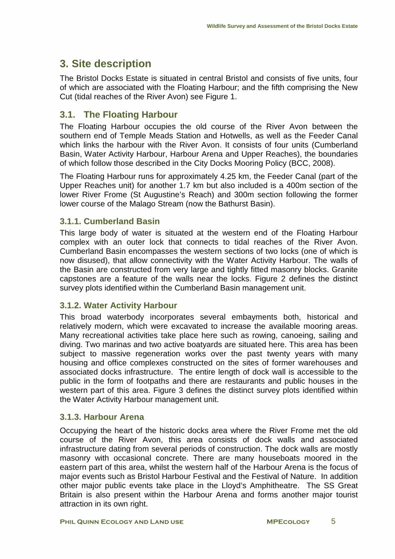
3. Site description The Bristol Docks Estate is situated in central Bristol and consists of five units, four of which are associated with the Floating Harbour; and the fifth comprising the New Cut (tidal reaches of the River Avon) see Figure 1.
3.1. The Floating Harbour The Floating Harbour occupies the old course of the River Avon between the southern end of Temple Meads Station and Hotwells, as well as the Feeder Canal which links the harbour with the River Avon. It consists of four units (Cumberland Basin, Water Activity Harbour, Harbour Arena and Upper Reaches), the boundaries of which follow those described in the City Docks Mooring Policy (BCC, 2008).
The Floating Harbour runs for approximately 4.25 km, the Feeder Canal (part of the Upper Reaches unit) for another 1.7 km but also included is a 400m section of the lower River Frome (St Augustine’s Reach) and 300m section following the former lower course of the Malago Stream (now the Bathurst Basin).
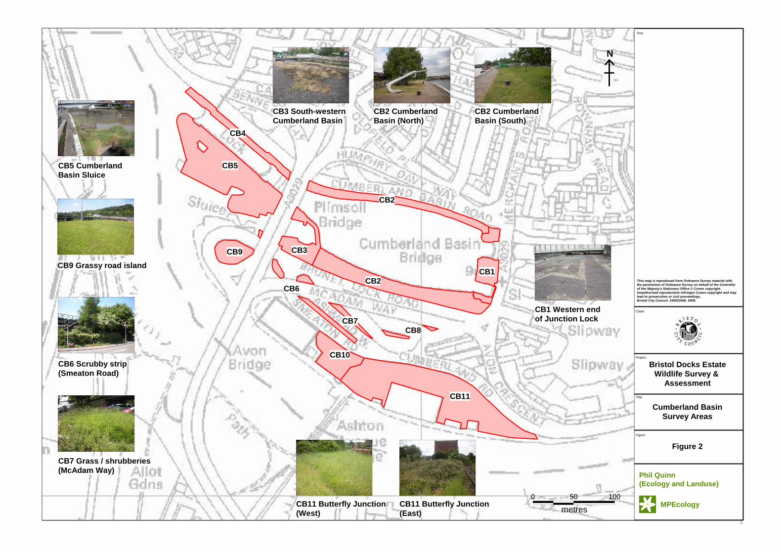
3.1.1. Cumberland Basin This large body of water is situated at the western end of the Floating Harbour complex with an outer lock that connects to tidal reaches of the River Avon. Cumberland Basin encompasses the western sections of two locks (one of which is now disused), that allow connectivity with the Water Activity Harbour. The walls of the Basin are constructed from very large and tightly fitted masonry blocks. Granite capstones are a feature of the walls near the locks. Figure 2 defines the distinct survey plots identified within the Cumberland Basin management unit.
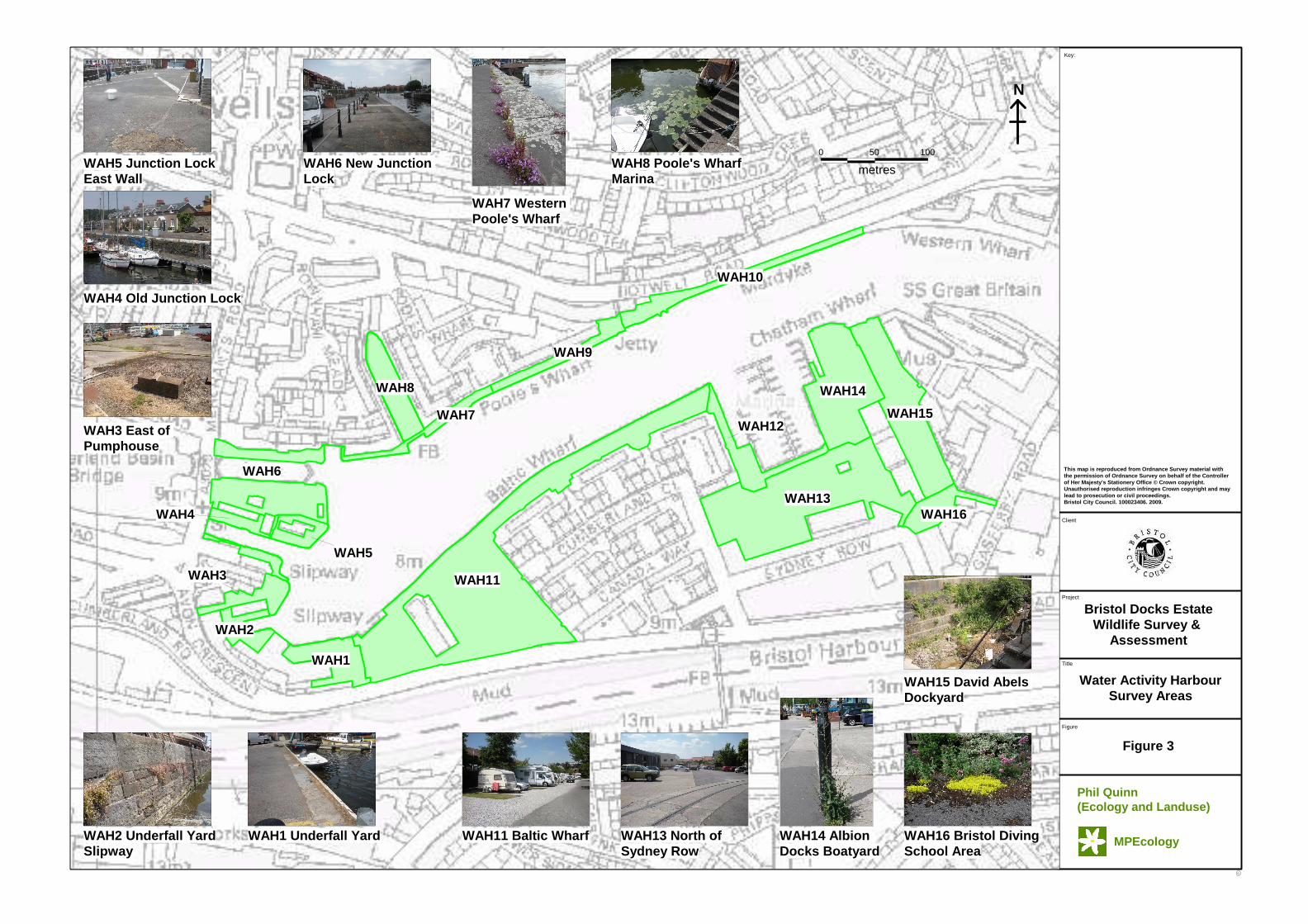
3.1.2. Water Activity Harbour This broad waterbody incorporates several embayments both, historical and relatively modern, which were excavated to increase the available mooring areas. Many recreational activities take place here such as rowing, canoeing, sailing and diving. Two marinas and two active boatyards are situated here. This area has been subject to massive regeneration works over the past twenty years with many housing and office complexes constructed on the sites of former warehouses and associated docks infrastructure. The entire length of dock wall is accessible to the public in the form of footpaths and there are restaurants and public houses in the western part of this area. Figure 3 defines the distinct survey plots identified within the Water Activity Harbour management unit.
3.1.3. Harbour Arena
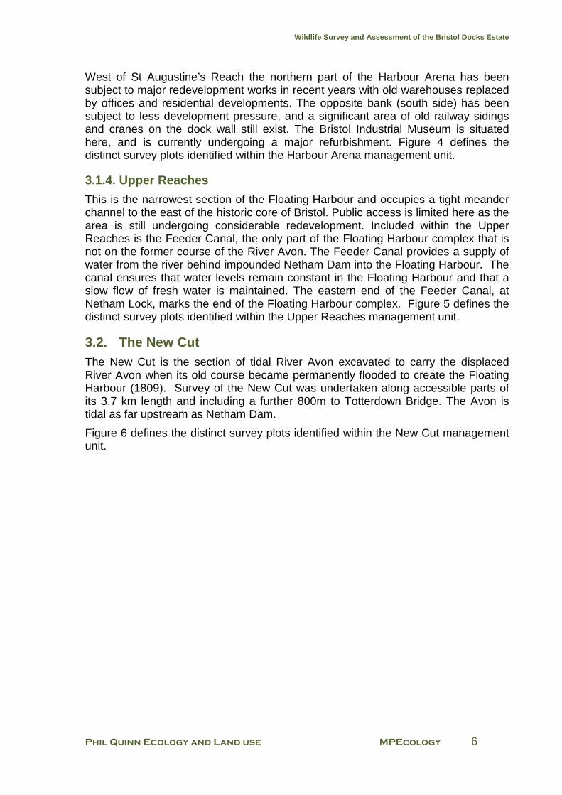
Occupying the heart of the historic docks area where the River Frome met the old course of the River Avon, this area consists of dock walls and associated infrastructure dating from several periods of construction. The dock walls are mostly masonry with occasional concrete. There are many houseboats moored in the eastern part of this area, whilst the western half of the Harbour Arena is the focus of major events such as Bristol Harbour Festival and the Festival of Nature. In addition other major public events take place in the Lloyd’s Amphitheatre. The SS Great Britain is also present within the Harbour Arena and forms another major tourist attraction in its own right.
Wildlife Survey and Assessment of the Bristol Docks Estate
Phil Quinn Ecology and Land use MPEcology 6
West of St Augustine’s Reach the northern part of the Harbour Arena has been subject to major redevelopment works in recent years with old warehouses replaced by offices and residential developments. The opposite bank (south side) has been subject to less development pressure, and a significant area of old railway sidings and cranes on the dock wall still exist. The Bristol Industrial Museum is situated here, and is currently undergoing a major refurbishment. Figure 4 defines the distinct survey plots identified within the Harbour Arena management unit.
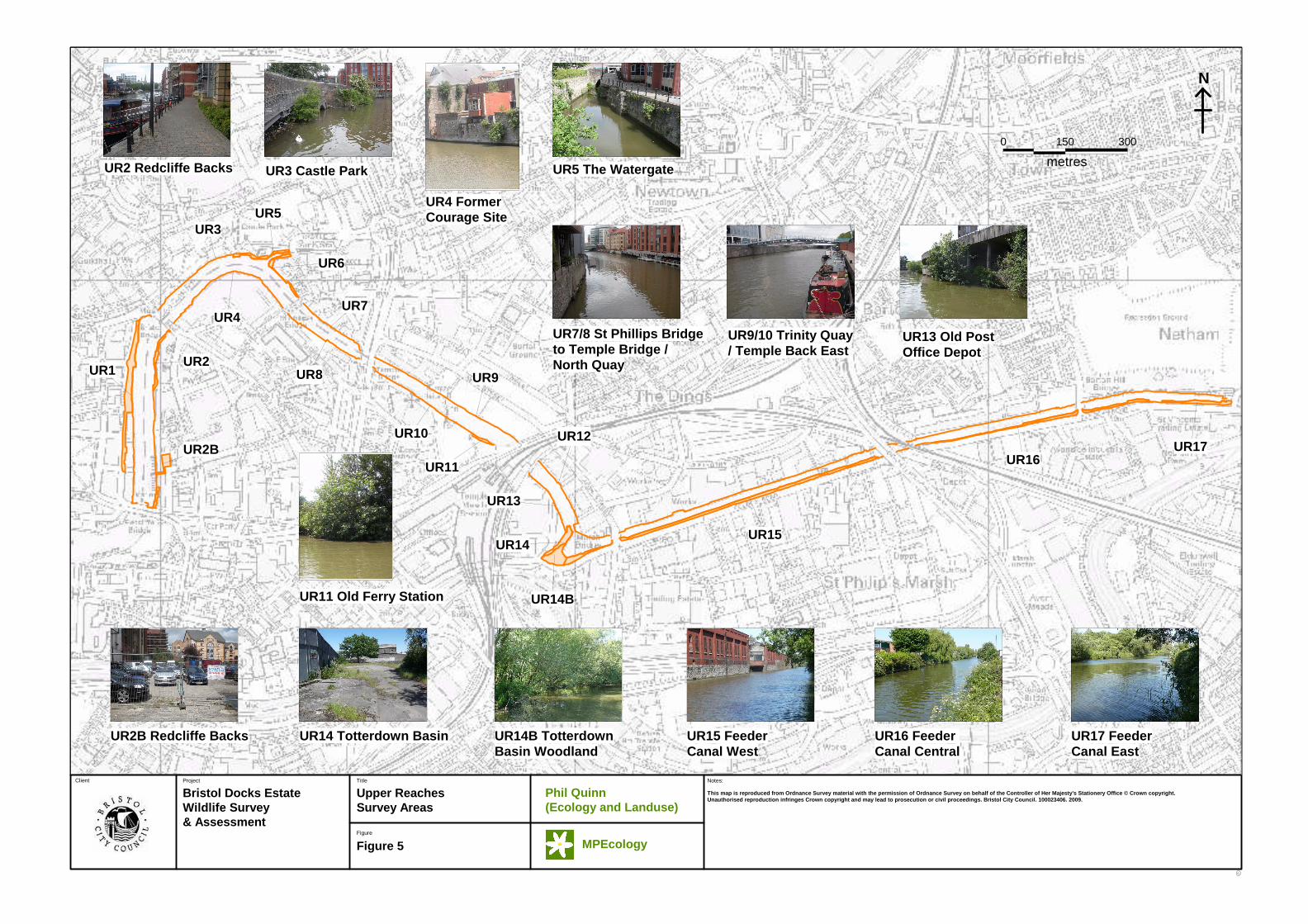
3.1.4. Upper Reaches
This is the narrowest section of the Floating Harbour and occupies a tight meander channel to the east of the historic core of Bristol. Public access is limited here as the area is still undergoing considerable redevelopment. Included within the Upper Reaches is the Feeder Canal, the only part of the Floating Harbour complex that is not on the former course of the River Avon. The Feeder Canal provides a supply of water from the river behind impounded Netham Dam into the Floating Harbour. The canal ensures that water levels remain constant in the Floating Harbour and that a slow flow of fresh water is maintained. The eastern end of the Feeder Canal, at Netham Lock, marks the end of the Floating Harbour complex. Figure 5 defines the distinct survey plots identified within the Upper Reaches management unit.
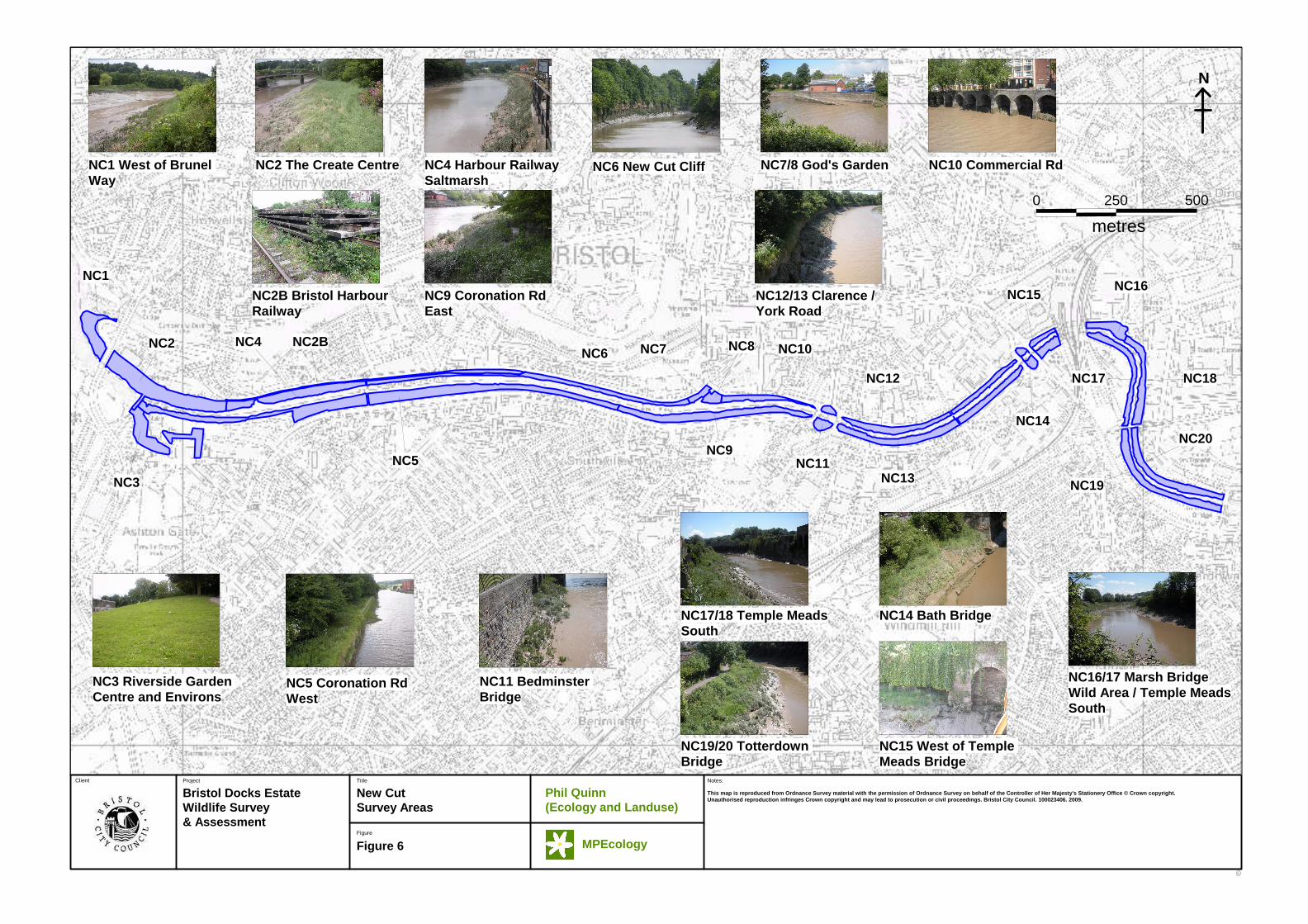
3.2. The New Cut The New Cut is the section of tidal River Avon excavated to carry the displaced River Avon when its old course became permanently flooded to create the Floating Harbour (1809). Survey of the New Cut was undertaken along accessible parts of its 3.7 km length and including a further 800m to Totterdown Bridge. The Avon is tidal as far upstream as Netham Dam.
Figure 6 defines the distinct survey plots identified within the New Cut management unit.
C
Project Title
Bristol Docks EstateWildlife Survey & Assessment
Management Unitswithin the Docks Estate
C
Figure
Client
Figure 1
Notes:
1,000500
metres
0
N
Water Activity Harbour (WAH)
Harbour Arena (HA)
Upper Reaches (UR)CumberlandBasin (CB)
New Cut (NC)
Phil Quinn (Ecology and Landuse)
MPEcology
This map is reproduced from Ordnance Survey materia l with the permission of Ordnance Survey on behalf of the Controller of Her Majesty's Stationery Offic e © Crown copyright. Unauthorised reproduction infr inges Crown copyright and may lead to prosecution o r civil proceedings. Bristol City Council. 10002340 6. 2009.
C
Project
Title
Bristol Docks EstateWildlife Survey &
Assessment
Cumberland BasinSurvey Areas
C
Figure
Client
Figure 2
Key:
No Window
0 50 100
metres
CB2
CB1
CB3
CB4
CB6
CB11
CB8
CB10
CB7
CB9
CB2
CB5
N
CB3 South-westernCumberland Basin
CB2 Cumberland Basin (North)
CB2 Cumberland Basin (South)
CB1 Western end of Junction Lock
CB5 CumberlandBasin Sluice
CB9 Grassy road island
CB6 Scrubby strip(Smeaton Road)
CB7 Grass / shrubberies(McAdam Way)
CB11 Butterfly Junction(West)
CB11 Butterfly Junction(East)
Phil Quinn (Ecology and Landuse)
MPEcology
This map is reproduced from Ordnance Survey materia l with the permission of Ordnance Survey on behalf of the Controller of Her Majesty's Stationery Office © Crown copyrigh t. Unauthorised reproduction infringes Crown copyright and may lead to prosecution or civil proceedings. Bristol City Council. 100023406. 2009.
C
Project
Title
Bristol Docks EstateWildlife Survey &
Assessment
Water Activity HarbourSurvey Areas
C
Figure
Client
Figure 3
Key:
No Window
100
metres
0 50
WAH6
WAH4
WAH5
WAH14
WAH15
WAH11WAH3
WAH12WAH7
WAH1
WAH16WAH13
WAH2
WAH8
WAH9
WAH10
N
WAH8 Poole's WharfMarina
Phil Quinn (Ecology and Landuse)
MPEcology
WAH7 Western Poole's Wharf
WAH6 New Junction Lock
WAH5 Junction LockEast Wall
WAH4 Old Junction Lock
WAH3 East of Pumphouse
WAH2 Underfall YardSlipway
WAH1 Underfall Yard WAH11 Baltic Wharf WAH13 North ofSydney Row
WAH14 AlbionDocks Boatyard
WAH16 Bristol DivingSchool Area
WAH15 David Abels Dockyard
This map is reproduced from Ordnance Survey materia l with the permission of Ordnance Survey on behalf of the Controller of Her Majesty's Stationery Office © Crown copyrigh t. Unauthorised reproduction infringes Crown copyright and may lead to prosecution or civil proceedings. Bristol City Council. 100023406. 2009.
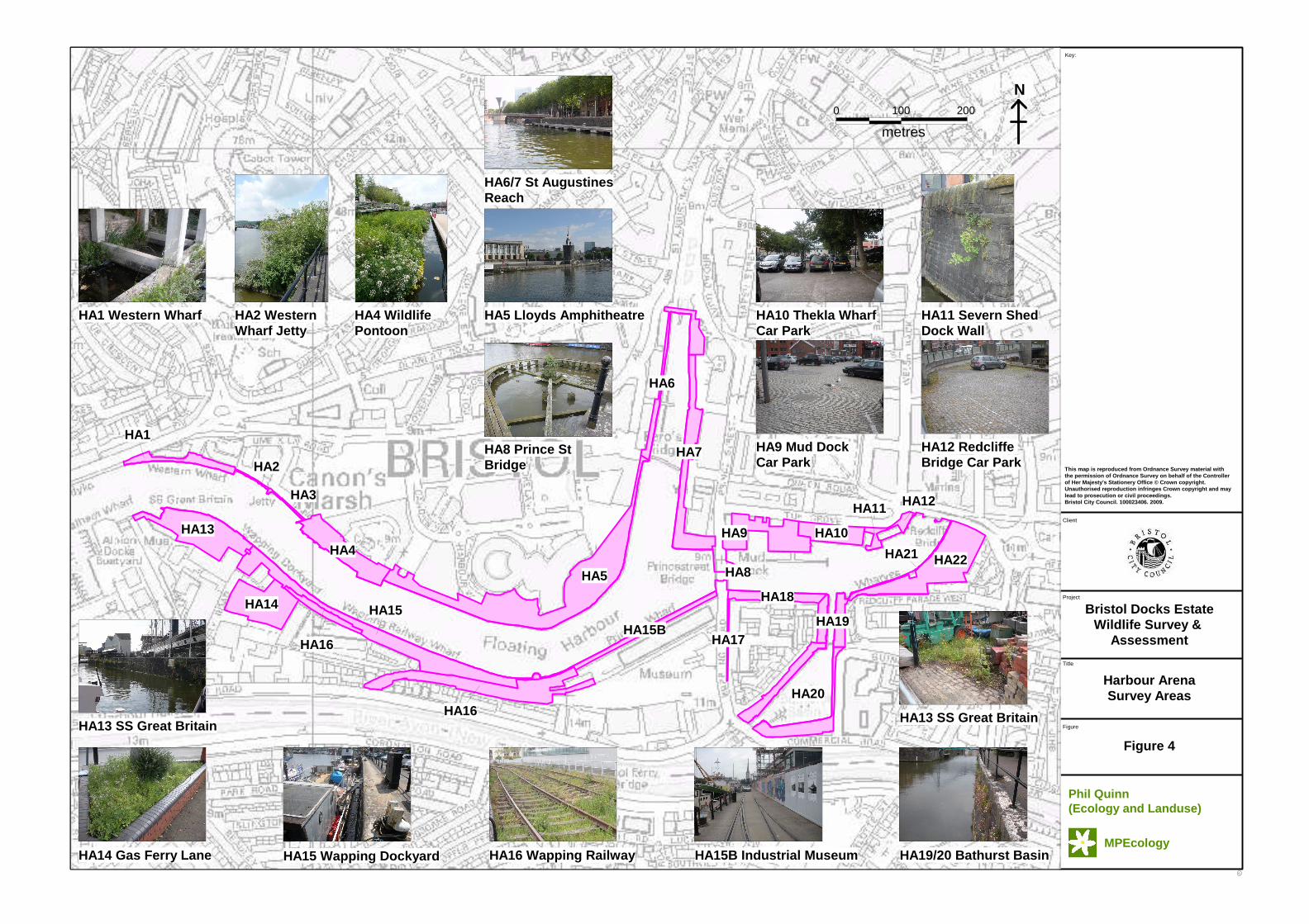
C
Project
Title
Bristol Docks EstateWildlife Survey &
Assessment
Harbour ArenaSurvey Areas
C
Figure
Client
Figure 4
Key:
No Window
metres
0 100 200
HA11
HA21
HA12
HA16
HA16
HA13
HA15
HA8HA5
HA19
HA1
HA3
HA2
HA20
HA14
HA9 HA10
HA17
HA4
HA7
HA15B
HA18
HA22
HA6
N
HA6/7 St AugustinesReach
HA5 Lloyds AmphitheatreHA4 WildlifePontoon
HA1 Western Wharf
HA8 Prince StBridge
HA9 Mud DockCar Park
HA10 Thekla WharfCar Park
HA11 Severn ShedDock Wall
HA12 Redcliffe Bridge Car Park
HA13 SS Great Britain
Phil Quinn (Ecology and Landuse)
MPEcology
This map is reproduced from Ordnance Survey materia l with the permission of Ordnance Survey on behalf of the Controller of Her Majesty's Stationery Office © Crown copyrigh t. Unauthorised reproduction infringes Crown copyright and may lead to prosecution or civil proceedings. Bristol City Council. 100023406. 2009.
HA2 Western Wharf Jetty
HA14 Gas Ferry Lane HA15 Wapping Dockyard HA16 Wapping Railway HA15B Industrial Museum HA19/20 Bathurst Basin
HA13 SS Great Britain
C
Project Title
Bristol Docks EstateWildlife Survey & Assessment
Upper ReachesSurvey Areas
C
Figure
Client
Figure 5
Notes:
0 150 300
metres
UR11
UR9
UR10
UR13
UR14
UR14B
UR2B
UR1UR2
UR4
UR6
UR5
UR7
UR8
UR17UR16
UR15
UR12
UR3
N
This map is reproduced from Ordnance Survey materia l with the permission of Ordnance Survey on behalf of the Controller of Her Majesty's Stationery Offic e © Crown copyright. Unauthorised reproduction infringes Crown copyright and may lead to prosecution or civil proceedings. Bristol City Council. 100023406. 2009.
Phil Quinn (Ecology and Landuse)
MPEcology
UR2B Redcliffe Backs UR14 Totterdown Basin UR14B TotterdownBasin Woodland
UR15 FeederCanal West
UR16 Feeder Canal Central
UR17 FeederCanal East
UR7/8 St Phillips Bridge to Temple Bridge / North Quay
UR9/10 Trinity Quay/ Temple Back East
UR13 Old PostOffice Depot
UR2 Redcliffe Backs UR3 Castle Park
UR4 FormerCourage Site
UR5 The Watergate
UR11 Old Ferry Station
C
Project Title
Bristol Docks EstateWildlife Survey & Assessment
New CutSurvey Areas
C
Figure
Client
Figure 6
Notes:
500
metres
2500
NC19
NC20
NC17
NC14
NC18
NC15NC16
NC12
NC13NC11
NC10NC8
NC9
NC7NC6
NC5
NC4 NC2B
NC3
NC2
NC1
N
This map is reproduced from Ordnance Survey materia l with the permission of Ordnance Survey on behalf of the Controller of Her Majesty's Stationery Offic e © Crown copyright. Unauthorised reproduction infringes Crown copyright and may lead to prosecution or civil proceedings. Bristol City Council. 100023406. 2009.
Phil Quinn (Ecology and Landuse)
MPEcology
NC1 West of Brunel Way
NC2 The Create Centre NC4 Harbour RailwaySaltmarsh
NC6 New Cut Cliff NC7/8 God's Garden NC10 Commercial Rd
NC3 Riverside Garden Centre and Environs
NC2B Bristol HarbourRailway
NC16/17 Marsh BridgeWild Area / Temple MeadsSouth
NC17/18 Temple MeadsSouth
NC5 Coronation RdWest
NC14 Bath Bridge
NC11 Bedminster Bridge
NC9 Coronation RdEast
NC12/13 Clarence /York Road
NC15 West of Temple Meads Bridge
NC19/20 Totterdown Bridge
Wildlife Survey and Assessment of the Bristol Docks Estate
Phil Quinn Ecology and Land use MPEcology 13
4. Results and Assessment
4.1 Biodiversity hotspots This survey has clearly demonstrated that there are a number of sites with exceptional biodiversity value within the Docks Estate. These sites will be not only of value within an urban Bristol context but arguably within a wider regional context given their species composition and size. There are also other tiers of sites which are of high or moderate biodiversity value, especially given the urban context in which they are found.
Outstanding sites: Wapping / Bristol Harbour Railway Sidings (HA16 / NC2B) Butterfly Junction (CB11) Totterdown Basin Wet Woodland (UR14B) River Avon Saltmarsh (NC1 - 20)
High value sites Redcliffe Brownfield (HA22) Feeder Canal West (UR15/16) Bathurst Basin (HA20) David Abels Boatyard (WAH15) Wild area east of Temple Meads (NC16)
Other valuable sites Dock wall at SS Great Britain (HA13) Dock walls and pavements at western end of Water Activity Harbour (WAH4 - 6) Dock wall in front of the Industrial Museum (HA15B) Grassy roundabout at Cumberland Basin (CB9) The Watergate (Arable plants) (UR5)
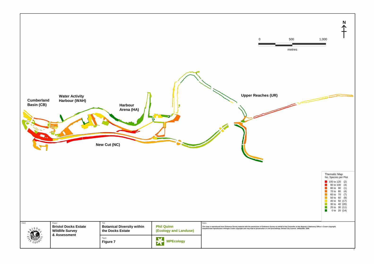
4.2 Management Units For a full account of each distinct survey plot, see Appendices1-5. However, descriptions of findings for each management unit are provided below. In addition, an overview illustrating botanical diversity within the Docks Estate is provided by Figure 7, a thematic map plotting number of species recorded in each plot of the study area. An area’s botanical diversity is not necessarily equivalent to its nature conservation value but this is frequently the case within the Dock Estate.
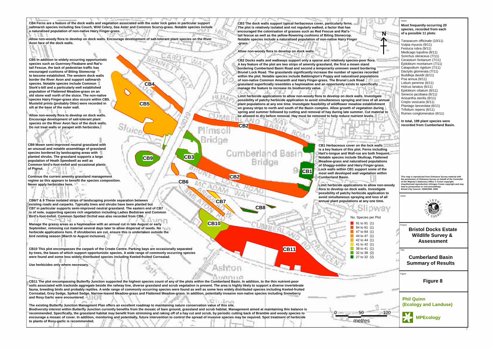
4.2.1. Cumberland Basin
Cumberland Basin, or at least those parts of it immediately enclosing the open water of the docks, is generally of low nature conservation value. The Basin walls support relatively little vegetation, although many individual species are often present. The outer face of the Basin (the lower section of area NC1, part of the tidal Avon) supports a saltmarsh community and uncommon species such as flattened meadow-grass (Poa compressa) occur on the upper walls of this outer face. There is greater botanical interest on the horizontal surfaces to the north and south of the Basin itself. On the northern side there is a large population of the scarce alien, hairy finger-grass (Digitaria sanguinalis), which is particularly prevalent in pavement
Wildlife Survey and Assessment of the Bristol Docks Estate
Phil Quinn Ecology and Land use MPEcology 14
cracks. Other notable aliens here include common amaranth (Amaranthus retroflexus).
There is limited potential here for breeding birds, mammals or invertebrates. No animal species of note were recorded. Cumberland Basin is frequently drained to facilitate dredging and inspection of the masonry walls, which, combined with the frequent movement of often large vessels, means opportunities for establishing wildlife-friendly features here are limited.
However, although this may be true of much of this management unit, an area known as Butterfly Junction (CB11) lies to the south-east. Butterfly Junction was found to be the most diverse of the Cumberland Basin plots sampled during the survey. This plot is associated with an infrequently used railway line and supports a mosaic of diverse grassland, tall herbs, bramble and scrub cover. Butterfly Junction hosts a diverse flora, a wealth of invertebrates and is considered highly likely to support reptiles and breeding birds.
Figure 8 provides a summary of notable species recorded within Cumberland Basin and management options for each distinct survey plot identified. Further details of individual survey plots can be found in Appendix 1.
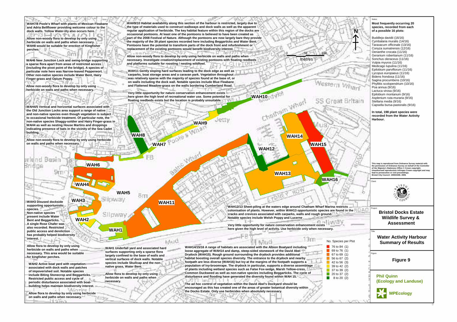
4.2.2. Water Activity Harbour
Docks and slipways at the western end of this area support rich and diverse plant assemblages including native species associated with wetlands and disturbed ground as well as alien species, mostly annuals, where disturbed ground conditions exist. Hairy finger-grass is locally common here along with small populations of another alien grass, water bent (Polypogon viridis). The dock walls in the west (e.g. WAH7) are frequently very colourful with large populations of the attractive alien garden escapes, Mexican fleabane (Erigeron karvinskianus) and both trailing bellflower (Campanula poscharskyana) and Adria bellflower (Campanula portenschlagiana). The remaining dock walls are more sparingly vegetated and there is generally a low biodiversity value to the eastern half of the Water Activity Harbour.
There is a large colony of house martins (Delichon urbica), in the west of the Water Activity Harbour, with many nests on the waterside properties of the Poole’s Wharf housing complex (WAH7 & WAH8) and a smaller numbers on the Sea Cadet’s building situated between the Old and New Junction Locks (WAH5).
Also of note at the Sea Cadet’s building were several fresh bat droppings at the base of the western gable end. These droppings were most probably from a Myotis species and their position indicates that a bat roost may exist in this building.
Cormorants frequently roost on buoys near Underfall Yard (WAH1) in close proximity to the shore where the public can view them without the aid of binoculars.
Of all the plots sampled within the Water Activity Harbour during the survey, the working dockyard at WAH15 was found to be the most diverse.
A complete account of survey findings can be found in Appendix 2. Figure 9 summarises survey findings and management options for each distinct survey plot within the Water Activity Harbour.
Wildlife Survey and Assessment of the Bristol Docks Estate
Phil Quinn Ecology and Land use MPEcology 15
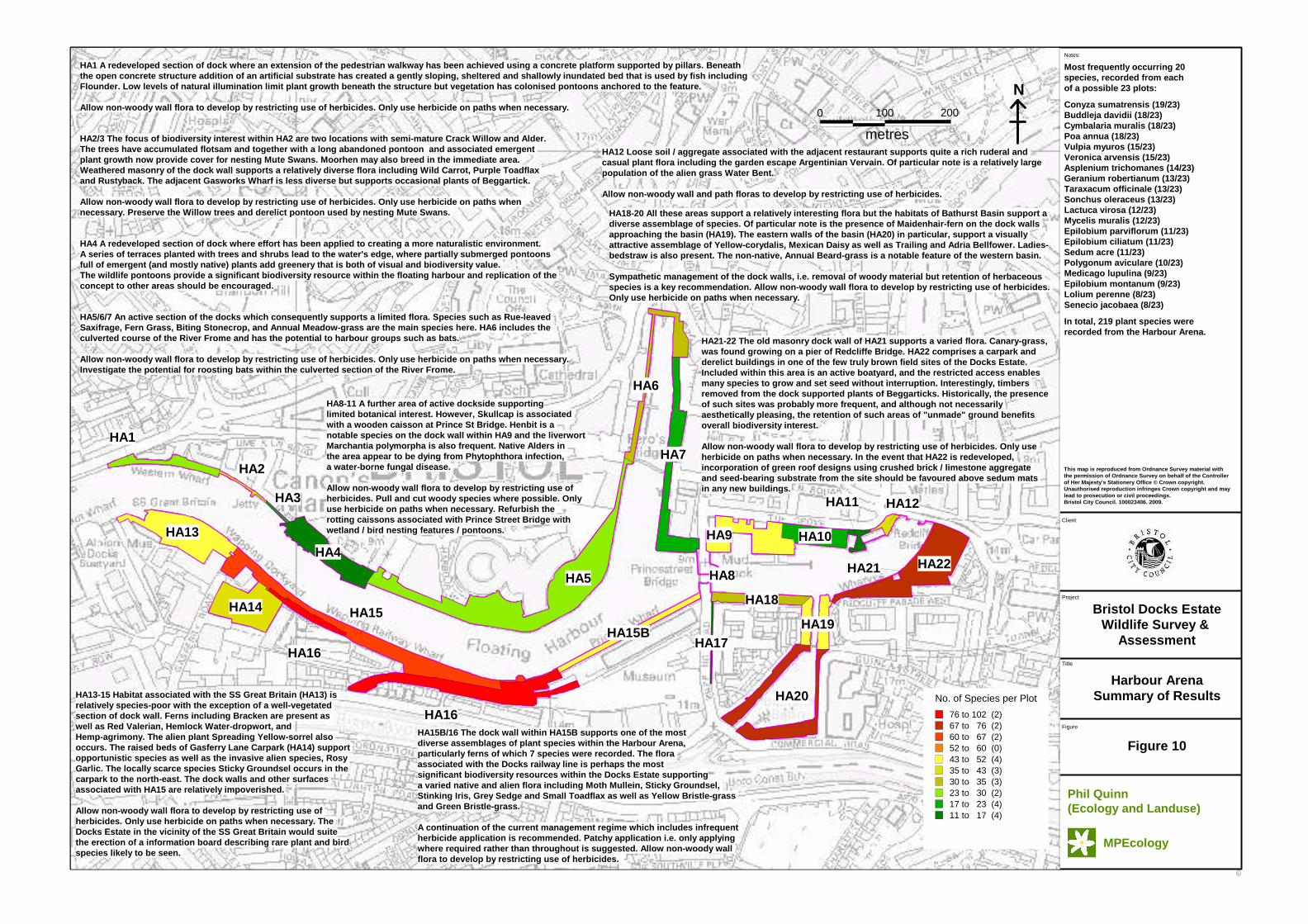
4.2.3. Harbour Arena
This large and structurally complex area is rather poor in biodiversity along its northern edge from Western Wharf to Princes’s Street Bridge. However, a notable exception to this are recently constructed floating reedbed pontoons created as part of the waterfront landscaping works for residential development at Canon’s Marsh (HA4). This reedbed feature comprises mostly native aquatic herbaceous species and provides breeding habitat for at least four species of damselfly, in addition to being an attractive feature in an otherwise hard engineered landscape.
On the opposite bank (HA13) the dock wall associated with the SS Great Britain is rich in native and alien herbs and grasses. A small section of relatively sparse dock wall separates the SS Great Britain wall from a very species rich section: the disused Wapping Wharf Railway (HA16). This system of derelict railway sidings has an exceptionally rich diversity of plant species including local rarities such as moth mullein (Verbascum blattaria) and scarce alien grasses such as green bristle-grass (Setaria viridis). The railway sidings complex is one of the main biodiversity hotspots within the entire survey area and supports a range of species not encountered elsewhere. It is likely to support a diverse assemblage of invertebrates.
East of Prince’s Street Bridge the various basins and wharves leading up to Redcliffe Bridge are not particularly noteworthy, although some unusual plants are found here: henbit (Lamium amplexicaule) on Prince’s Street Bridge itself, maidenhair fern (Asplenium capillus-veneris) at the entrance to Bathurst Basin and good populations of the unusual liverwort (Marchantia polymorpha) with its bizarre star-shaped fruiting body, are all found in this area.
One of the most interesting parts of the Harbour Arena (excluding the railway sidings complex) is a small brownfield site on the extreme eastern edge adjacent to the Redcliffe Hill roundabout (HA22). Although no rarities were found here there is a very rich diversity of casual plant species, which provide an extensive source of nectar and pollen for bees (one of the few sites within the survey area where large numbers of bees were recorded). Derelict buildings also appeared to offer potential bat roosts.
A complete account of survey findings can be found in Appendix 3. Figure 10 summarises survey findings and management options for each distinct survey plot within the Harbour Arena.
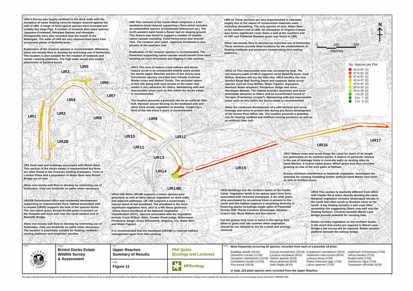
4.2.4. Upper Reaches
Comprising the upper part of the Floating Harbour and the entirety of the Feeder Canal this area has two very distinct characters. Downstream from Totterdown Basin (UR14 which marks the western end of the Feeder Canal) the complex is lacking in biodiversity and is particularly hard engineered with few concessions to naturalistic landscaping as part of very recent redevelopment works. Within this largely sterile environment a few features stand out. Near Temple Meads, a small area of dense scrub marking an old ferry station (UR11), offers the possibility of a quiet resting site for otters and is essentially the only area with any nature conservation value locally. Near the Water Gate (UR5), a small landscaped flowerbed supports unusual native annual herbs such as common penny-cress
Wildlife Survey and Assessment of the Bristol Docks Estate
Phil Quinn Ecology and Land use MPEcology 16
(Thlaspi arvense) and smooth tare (Vicia terapserma) and is the only other area of any biodiversity interest.
In contrast, the Feeder Canal is of exceptional nature conservation value, within an inner Bristol City context, and the very wide diversity of plant species recorded here include pyramidal orchid (Anacamptis pyramidalis), milk thistle (Silybum marianum), common broomrape (Orobanche minor) and water whorl-grass (Catabrosa aquatica). It is also along the Feeder that a large number of otter spraints were recorded and a colony of sand martins identified. At the western end of the Feeder Canal and Totterdown Basin a remarkable area of wet woodland habitat is present. This has developed over sixty years of non-intervention, supports an assemblage of native wetland species not found elsewhere within the Docks Estate and is very natural in character. A grassland plot at the western end of the Feeder Canal (UR15) was found to be the most diverse of the plots sampled within the Upper Reaches.
A complete account of survey findings can be found in Appendix 4. Figure 11 summarises the survey findings and management options for each distinct survey plot within the Upper Reaches.
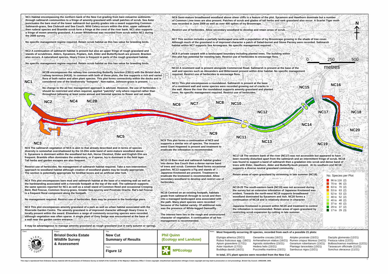
4.2.5. New Cut
The majority of this watercourse was created to channel a section of the River Avon after its original course was used to form the Floating Harbour. However, there is a small upper section which flows within the original course of the Avon. The whole length of this section is tidal, and the large tidal range means that much silt is exposed at low water. A band of middle and upper saltmarsh vegetation is found along the banks of the river throughout the whole survey section and saltmarsh species can also often be found on the masonry walls which act as revetments through most of the course of the New Cut.
Above the influence of the tide there is often a band of scrub or secondary woodland, which ranges between 5m and 30m in width. This habitat is frequently species-poor but perhaps offers the best breeding bird and generalist invertebrate habitat within the entire survey area.
In terms of plant numbers three areas sampled during the survey stood out from all others: a section of the harbour railway (NC2B); the southern bank of the New Cut at NC5; and habitat east of Temple Meads (NC16/18). Of these, NC2B and NC16/18 are considered of most interest, with the high species tally of NC5 largely due to presence of secondary woodland habitat and size.
A complete account of survey findings can be found in Appendix 5. Figure 12 summarises survey findings and management options for each distinct survey plot within the New Cut.
C
Project Title
Bristol Docks EstateWildlife Survey & Assessment
Botanical Diversity within the Docks Estate
C
Figure
Client
Figure 7
Notes:
1,000
metres
5000
N
Water Activity Harbour (WAH)
Harbour Arena (HA)
Upper Reaches (UR)CumberlandBasin (CB)
New Cut (NC)
This map is reproduced from Ordnance Survey materia l with the permission of Ordnance Survey on behalf of the Controller of Her Majesty's Stationery Offic e © Crown copyright. Unauthorised reproduction infringes Crown copyright and may lead to prosecution or civil proceedings. Bristol City Council. 100023406. 2009.
Phil Quinn (Ecology and Landuse)
MPEcology
Thematic Map No. Species per Plot
100 to 120 (2)90 to 100 (4)80 to 90 (1)70 to 80 (4)60 to 70 (7)50 to 60 (9)40 to 50 (17)30 to 40 (20)20 to 30 (11)0 to 20 (14)
C
Project
Title
Bristol Docks EstateWildlife Survey &
Assessment
Cumberland BasinSummary of Results
C
Figure
Client
Figure 8
Notes:
No Window
0 50 100
metres
CB2
CB11
CB1
CB3
CB4
CB6
CB8
CB10
CB7
CB9
CB2
CB5
N
CB1 Herbaceous cover on the lock walls is a key feature of this plot. Ferns includingHart's-tongue and Wall-rue are both frequent.Notable species include Skullcap, Flattened Meadow-grass and naturalised populations of Shaggy-soldier and Hairy Finger-grass.Lock walls within CB1 support some of the most well developed wall vegetation within Cumberland Basin.
Limit herbicide applications to allow non-woodyflora to develop on dock walls. Investigatepossibility of patchy herbicide application to avoid simultaneous spraying and loss of all annual plant populations at any one time.
Phil Quinn (Ecology and Landuse)
MPEcology
This map is reproduced from Ordnance Survey materia l with the permission of Ordnance Survey on behalf of the Controller of Her Majesty's Stationery Office © Crown copyrigh t. Unauthorised reproduction infringes Crown copyright and may lead to prosecution or civil proceedings. Bristol City Council. 100023406. 2009.
Taraxacum officinale (10/11)Vulpia myuros (9/11)Festuca rubra (9/11)Medicago lupulina (8/11)Sonchus oleraceus (7/11)Cerastium fontanum (7/11)Epilobium montanum (7/11)Catapodium rigidum (7/11)Dactylis glomerata (7/11)Buddleja davidii (6/11)Poa annua (6/11)Lolium perenne (6/11)Holcus lanatus (6/11)Epilobium ciliatum (6/11)Senecio jacobaea (6/11)Anisantha sterilis (6/11)Crepis vesicaria (6/11)Plantago lanceolata (6/11)Trifolium repens (6/11)Rumex conglomeratus (6/11)
Most frequently occurring 20species, recorded from eachof a possible 11 plots:
In total, 199 plant species were recorded from Cumberland Basin.
CB2 Docks walls and walkways support only a sparse and relatively species-poor flora. A key feature of the plot are two strips of amenity grassland, the first a mown stand bordering Cumberland Basin Road and second a tempor arily unmown sward bordering Brunel Lock Road. The grasslands significantly incr ease the number of species recorded within the plot. Notable species include Babbington 's Poppy and naturalised populations of non-native Common Amaranth and Hairy Finger-gras s. The Brunel Lock Road grassland superficially resembles a haymeadow and a n opportunity exists to specifically manage the feature to increase its biodiversity val ue.
Limit herbicide applications to allow non-woody flo ra to develop on dock walls. Investigate possibility of patchy herbicide application to avoi d simultaneous spraying and loss of all annual plant populations at any one time. Investigate feas ibility of wildflower meadow establishment on grassy strips to north and south of the Basin co mplex. Allow growth of vegetation during spring and summer followed by cutting and removal o f hay during late summer. Cut material to be allowed to dry before removal. Hay must be remov ed to help reduce nutrient levels.
CB3 The dock walls support typical herbaceous cover , particularly ferns. The plot is relatively isolated and not regularly w alked, a factor that has encouraged the colonisation of grasses such as Red Fescue and Rat's-tail fescue as well as the yellow-flowering cushion s of Biting Stonecrop.Notable species include a naturalised population of non-native Hairy Finger-grass.
Allow non-woody flora to develop on dock walls.
CB4 Ferns are a feature of the dock walls and veget ation associated with the outer lock gates in parti cular support saltmarsh species including Sea Couch, Wild Celery, Sea Aster and Common Scurvy-grass. Notable species include a naturalised population of non-native Hairy Finger -grass.
Allow non-woody flora to develop on dock walls. Enc ourage development of salt-tolerant plant species o n the River Avon face of the dock walls.
CB5 In addition to widely occurring opportunistic species such as Guernsey Fleabane and Rat's-tail Fescue, the lack of pedestrian traffic has encouraged cushions of Biting Stonecrop to become established. The western dock walls border the River Avon and support saltmarsh species. Notable species include Common Stork's-bill and a particularly well established population of Flattened Meadow-grass on an old stone wall north of the sluice. The non-native species Hairy Finger-grass also occurs within CB5. Mustelid prints (probably Otter) were recorded in silt at the base of the outer wall.
Allow non-woody flora to develop on dock walls. Encourage development of salt-tolerant plant species on the River Avon face of the dock walls. Do not treat walls or parapet with herbicides.
CB9 Mown semi-improved neutral grassland with an unusual and notable assemblage of grassland species bordered by landscaping areas with planted shrubs. The grassland supports a large population of Heath Speedwell as well as Common bird's-foot-trefoil and occasional plants of Pignut.
Continue the current amenity grassland management regime as this appears to benefit the species compo sition. Never apply herbicides here.
CB6/7 & 8 These isolated strips of landscaping prov ide separation betweenexisting roads and carparks. Typically trees and sh rubs have been planted but CB7 in particular supports semi-improved neutral gr assland. The eastern end of CB7 is of note, supporting species rich vegetation incl uding Ladies Bedstraw and Common Bird's-foot-trefoil. Common Spotted Orchid was also recorded from CB6.
Manage the grassy areas as a haymeadow with an annu al cut in late August or early September, removing cut material several days later to allow dispersal of seeds. No herbicide applications here. If shrubberies are cut , ensure this is undertaken outside the bird nesting season (March to August inclusive).
CB10 This plot encompasses the carpark of the Creat e Centre. Parking bays are occasionally separated by trees, the bases of which support opportunistic species. A wide range of commonly occurring species were found and some less widely distributed species including Keeled-fruited Cornsalad.
Use herbicides only where necessary.
CB11 The plot encompassing Butterfly Junction suppo rted the highest species count of any of the plots within the Cumberland Basin. In addition, to the th in nutrient-poor soils associated with trackside aggregate beside th e railway line, diverse grassland and scrub vegetat ion is present. The area is highly likely to suppor t a diverse invertebrate fauna, breeding birds and probably reptiles. A wide range of commonly occurring species were found as well as some less widely distributed species includ ing Keeled-fruited Cornsalad, Grey Sedge, Spiked Sedge, Narrow-leaved Meadow-grass and Flattened Meadow-grass. In additio n, potentially invasive non-native species includin g Snowberry and Rosy Garlic were encountered.
The existing Butterfly Junction Managment Plan offe rs an excellent roadmap to maintaining nature conse rvation value of this site.Biodiversity interest within Butterfly Junction cur rently benefits from the mosaic of bare ground, gra ssland and scrub habitat. Management aimed at maint aining this balance is recommended. Specifically, the grassland habitat ma y benefit from strimming and raking off of a hay cu t and scrub, by periodic cutting back of Bramble an d woody species to encourage a mosaic of cover. In addition, monitorin g and potentially, future intervention to control t he spread of invasive species may be required. Spot treatment of herbicide to plants of Rosy-garlic is recommended.
No. Species per Plot
91 to 91 (1)84 to 91 (1)47 to 84 (1)44 to 47 (1)42 to 44 (1)41 to 42 (1)38 to 41 (1)32 to 38 (2)27 to 32 (2)
C
Project
Title
Bristol Docks EstateWildlife Survey &
Assessment
Water Activity HarbourSummary of Results
C
Figure
Client
Figure 9
Notes:
No Window
100
metres
0 50
WAH6
WAH4
WAH14
WAH3
WAH1
WAH11
WAH5
WAH12WAH7 WAH15
WAH16WAH13
WAH2
WAH8
WAH9
WAH10
N
Phil Quinn (Ecology and Landuse)
MPEcology
This map is reproduced from Ordnance Survey materia l with the permission of Ordnance Survey on behalf of the Controller of Her Majesty's Stationery Office © Crown copyrigh t. Unauthorised reproduction infringes Crown copyright and may lead to prosecution or civil proceedings. Bristol City Council. 100023406. 2009.
Most frequently occurring 20species, recorded from eachof a possible 16 plots:
In total, 198 plant species were recorded from the Water ActivityHarbour.
Buddleja davidii (16/16)Cymbalaria muralis (14/16)Taraxacum officinale (13/16)Conyza sumatrensis (12/16)Oenanthe crocata (11/16)Geranium robertianum (11/16)Sonchus oleraceus (11/16)Vulpia myuros (11/16)Medicago lupulina (11/16)Epilobium parviflorum (11/16)Lycopus europaeus (11/16)Bidens frondosa (11/16)Sagina procumbens (10/16)Phyllitis scolopendrium (10/16)Poa annua (9/16)Lactuca virosa (9/16)Epilobium montanum (9/16)Asplenium ruta-muraria (9/16)Stellaria media (9/16)Capsella bursa-pastoralis (9/16)
No. Species per Plot
76 to 84 (1)69 to 76 (1)67 to 69 (1)56 to 67 (2)42 to 56 (3)39 to 42 (2)37 to 39 (2)20 to 37 (2)8 to 20 (2)
WAH1 Underfall yard and associated hardsurfaces supporting only a sparse floralargely confined to the base of walls andvertical surfaces of dock walls. Notable species include Skullcap and the non-native grass, Water Bent.
Allow flora to develop by only using herbicide on walls and paths when necessary.
WAH2 Active boat yard with vegetationassociated with dock walls and patches of impoverished soil. Notable species include Biting Stonecrop and Beggarticks.Restricted public access and cycle of periodic disturbance associated with boat-building helps maintain biodiversity interest.
Allow flora to develop by only using herbicide on walls and paths when necessary.
WAH3 Disused docksidesupporting opportunisticspecies. Non-native species present include Water Bent and Beggarticks. A single Rose Chafer was also recorded. Restricted public access and dereliction has probably helped biodiversity interest.
Allow flora to develop by only using herbicide on walls and paths when necessary. This area would be suitable for kingfisher perches.
WAH4/5 Vertical and horizontal surfaces associated with the Old Junction Locks area support a range of nati ve and non-native species even though vegetation is su bject to occasional herbicide treatment. Of particular no te, the non-native species Shaggy-soldier and Hairy Finger- grass in WAH4 as well as nesting House Martins and droppings indicating presence of bats in the vicinity of the Sea Cadet building.
Allow non-woody flora to develop by only using herb icide on walls and paths when necessary.
WAH6 New Junction Lock and swing-bridge supporting a sparse flora apart from areas of restricted acces s (including the pivot point of the bridge). A specie s of particular note here was Narrow-leaved Pepperwort. Other non-native species include Water Bent, Hairy Finger-grass and Opium Poppy.
Allow non-woody flora to develop by only using herbicide on walls and paths when necessary.
WAH7/8 Poole's Wharf with plants of Mexican Fleaban e and Adria Bellflower providing welcome colour to th e dock walls. Yellow Water-lily also occurs here.
Allow non-woody flora to develop by only using herbicide on walls and paths when necessary. WAH8 would be suitable for erection of Kingfisher perches.
WAH9/10 Habitat availability along this section of the harbour is restricted, largely due to the type of materials used to construct walkways an d dock walls as well as the apparent regular application of herbicide. The key habitat f eature within this region of the docks are occasional pontoons. At least one of the pontoons i s believed to have been created as part of the 2008 Festival of Nature. Although the p ontoons are now largely bare they provide the majority of the 39 plant species recorded here including Beggarticks and Water Bent.Pontoons have the potential to transform parts of t he dock front and refurbishment or replacement of the existing pontoons would benefit biodiversity interest.
Allow non-woody flora to develop by only using herb icide on walls and paths when necessary. Investigate creation/replacement of exis ting pontoons with floating reedbeds and platforms suitable for roosting / nesting wildf owl.
WAH11 Gently sloping hard surfaces leading to the d ock edge as well as carparks, boat storage areas and a caravan park. Ve getation throughout was relatively sparse with the majority of species found at the base of, or on walls including the dock wall. Notable species i nclude Blue Fleabane and Flattened Meadow-grass on the walls bordering C umberland Road.
Very little opportunity for nature conservation enh ancement exists here given the high level of recreational water use . Some potential for floating reedbeds exists but the location is probab ly unsuitable.
WAH12/13 Sheet-piling at the waters edge around Cha tham Wharf Marina restricts colonisation of plants. However, within WAH13 oppor tunistic species are found in the cracks and crevices associated with carparks, walls and rough ground.Notable species include Welsh Poppy and Lucerne .
Very little opportunity for nature conservation enh ancement exists here given the high level of activity. Use herbicid e only when necessary.
WAH14/15/16 A range of habitats are associated with the Albion Boatyard including loose aggregate of WAH14 and damp, steep-sided ston ework of the David Abel Drydock (WAH15). Rough ground surrounding the drydo ck provides additional habitat boosting overall species diversity. The ent rance to the drydock and nearby footpath are less diverse (WAH16) but Ivy at the ma rgins of the footpath supports a population of Ivy-broomrape. The drydock in particu lar, supports a diverse assemblage of plants including wetland species such as False F ox-sedge, Marsh Yellow-cress, Common Duckweed as well as non-native species inclu ding Beggarticks. The cycle of disturbance and flooding have generated the diversi ty found within WAH 15.
The ad hoc control of vegetation within the David A bel's Dockyard should be encouraged as this has created one of the areas of greater botanical diversity within the Docks Estate. Only use herbicides when absolute ly necessary.
C
Project
Title
Bristol Docks EstateWildlife Survey &
Assessment
Harbour ArenaSummary of Results
C
Figure
Client
Figure 10
Notes:
No Window
metres
0 100 200
HA16
HA16
HA11 HA12
HA21
HA15
HA13
HA8HA5
HA19
HA1
HA3
HA2
HA20
HA14
HA9 HA10
HA17
HA4
HA7
HA15B
HA18
HA22
HA6
N
Phil Quinn (Ecology and Landuse)
MPEcology
This map is reproduced from Ordnance Survey materia l with the permission of Ordnance Survey on behalf of the Controller of Her Majesty's Stationery Office © Crown copyrigh t. Unauthorised reproduction infringes Crown copyright and may lead to prosecution or civil proceedings. Bristol City Council. 100023406. 2009.
HA4 A redeveloped section of dock where effort has been applied to creating a more naturalistic enviro nment. A series of terraces planted with trees and shrubs lead to the water's edge, where partially submerged pontoons full of emergent (and mostly native) plants add gre enery that is both of visual and biodiversity value . The wildlife pontoons provide a significant biodive rsity resource within the floating harbour and repl ication of the concept to other areas should be encouraged.
HA1 A redeveloped section of dock where an extensio n of the pedestrian walkway has been achieved using a concrete platform supported by pillars. Beneath the open concrete structure addition of an artifici al substrate has created a gently sloping, sheltere d and shallowly inundated bed that is used by fish including Flounder. Low levels of natural illumination limit plant growth beneath the structure but vegetation h as colonised pontoons anchored to the feature.
Allow non-woody wall flora to develop by restrictin g use of herbicides. Only use herbicide on paths wh en necessary.
HA2/3 The focus of biodiversity interest within HA2 are two locations with semi-mature Crack Willow an d Alder. The trees have accumulated flotsam and together wit h a long abandoned pontoon and associated emergent plant growth now provide cover for nesting Mute Swa ns. Moorhen may also breed in the immediate area. Weathered masonry of the dock wall supports a relat ively diverse flora including Wild Carrot, Purple T oadflax and Rustyback. The adjacent Gasworks Wharf is less diverse but supports occasional plants of Beggartic k.
Allow non-woody wall flora to develop by restrictin g use of herbicides. Only use herbicide on paths wh en necessary. Preserve the Willow trees and derelict p ontoon used by nesting Mute Swans.
HA5/6/7 An active section of the docks which conseq uently supports a limited flora. Species such as Ru e-leaved Saxifrage, Fern Grass, Biting Stonecrop, and Annual Meadow-grass are the main species here. HA6 includ es the culverted course of the River Frome and has the pot ential to harbour groups such as bats.
Allow non-woody wall flora to develop by restrictin g use of herbicides. Only use herbicide on paths wh en necessary.Investigate the potential for roosting bats within the culverted section of the River Frome.
HA8-11 A further area of active dockside supportinglimited botanical interest. However, Skullcap is as sociated with a wooden caisson at Prince St Bridge. Henbit i s a notable species on the dock wall within HA9 and the liverwort Marchantia polymorpha is also frequent. Native Alde rs in the area appear to be dying from Phytophthora infec tion, a water-borne fungal disease.
Allow non-woody wall flora to develop by restrictin g use of herbicides. Pull and cut woody species where possib le. Only use herbicide on paths when necessary. Refurbish th e rotting caissons associated with Prince Street Brid ge withwetland / bird nesting features / pontoons.
HA12 Loose soil / aggregate associated with the adj acent restaurant supports quite a rich ruderal and casual plant flora including the garden escape Arge ntinian Vervain. Of particular note is a relatively large population of the alien grass Water Bent.
Allow non-woody wall and path floras to develop by restricting use of herbicides.
HA13-15 Habitat associated with the SS Great Britai n (HA13) is relatively species-poor with the exception of a wel l-vegetated section of dock wall. Ferns including Bracken are p resent as well as Red Valerian, Hemlock Water-dropwort, and Hemp-agrimony. The alien plant Spreading Yellow-sor rel also occurs. The raised beds of Gasferry Lane Carpark (H A14) support opportunistic species as well as the invasive alien species, Rosy Garlic. The locally scarce species Sticky Groundsel occurs in the carpark to the north-east. The dock walls and other surfaces associated with HA15 are relatively impoverished.
Allow non-woody wall flora to develop by restrictin g use of herbicides. Only use herbicide on paths when necess ary. The Docks Estate in the vicinity of the SS Great Britai n would suitethe erection of a information board describing rare plant and birdspecies likely to be seen.
HA15B/16 The dock wall within HA15B supports one of the mostdiverse assemblages of plant species within the Har bour Arena, particularly ferns of which 7 species were recorded . The flora associated with the Docks railway line is perhaps t he most significant biodiversity resources within the Docks Estate supportinga varied native and alien flora including Moth Mull ein, Sticky Groundsel, Stinking Iris, Grey Sedge and Small Toadflax as wel l as Yellow Bristle-grass and Green Bristle-grass.
A continuation of the current management regime whi ch includes infrequent herbicide application is recommended. Patchy applic ation i.e. only applying where required rather than throughout is suggested. Allow non-woody wall flora to develop by restricting use of herbicides.
HA18-20 All these areas support a relatively intere sting flora but the habitats of Bathurst Basin supp ort a diverse assemblage of species. Of particular note i s the presence of Maidenhair-fern on the dock walls approaching the basin (HA19). The eastern walls of the basin (HA20) in particular, support a visually attractive assemblage of Yellow-corydalis, Mexican Daisy as well as Trailing and Adria Bellfower. Ladi es-bedstraw is also present. The non-native, Annual Be ard-grass is a notable feature of the western basin .
Sympathetic management of the dock walls, i.e. remo val of woody material but retention of herbaceous species is a key recommendation. Allow non-woody wa ll flora to develop by restricting use of herbicide s. Only use herbicide on paths when necessary.
HA21-22 The old masonry dock wall of HA21 supports a varied flora. Canary-grass, was found growing on a pier of Redcliffe Bridge. HA 22 comprises a carpark and derelict buildings in one of the few truly brown fi eld sites of the Docks Estate. Included within this area is an active boatyard, an d the restricted access enables many species to grow and set seed without interrupt ion. Interestingly, timbers removed from the dock supported plants of Beggartic ks. Historically, the presence of such sites was probably more frequent, and altho ugh not necessarily aesthetically pleasing, the retention of such areas of "unmade" ground benefits overall biodiversity interest.
Allow non-woody wall flora to develop by restrictin g use of herbicides. Only use herbicide on paths when necessary. In the event tha t HA22 is redeveloped, incorporation of green roof designs using crushed b rick / limestone aggregateand seed-bearing substrate from the site should be favoured above sedum mats in any new buildings.
No. of Species per Plot
76 to 102 (2)67 to 76 (2)60 to 67 (2)52 to 60 (0)43 to 52 (4)35 to 43 (3)30 to 35 (3)23 to 30 (2)17 to 23 (4)11 to 17 (4)
Most frequently occurring 20species, recorded from eachof a possible 23 plots:
In total, 219 plant species were recorded from the Harbour Arena.
Conyza sumatrensis (19/23) Buddleja davidii (18/23) Cymbalaria muralis (18/23) Poa annua (18/23) Vulpia myuros (15/23) Veronica arvensis (15/23) Asplenium trichomanes (14/23) Geranium robertianum (13/23) Taraxacum officinale (13/23) Sonchus oleraceus (13/23) Lactuca virosa (12/23) Mycelis muralis (12/23) Epilobium parviflorum (11/23) Epilobium ciliatum (11/23) Sedum acre (11/23) Polygonum aviculare (10/23) Medicago lupulina (9/23) Epilobium montanum (9/23) Lolium perenne (8/23)Senecio jacobaea (8/23)
C
Project Title
Bristol Docks EstateWildlife Survey & Assessment
Upper ReachesSummary of Results
C
Figure
Client
Figure 11
Notes:
0 150 300
metres
UR4
UR5UR3
UR2B
UR8
UR7
UR11
UR9
UR10
UR13
UR14
UR14B
UR1UR2
UR6
UR17UR16
UR15
UR12
N
This map is reproduced from Ordnance Survey materia l with the permission of Ordnance Survey on behalf of the Controller of Her Majesty's Stationery Offic e © Crown copyright. Unauthorised reproduction infr inges Crown copyright and may lead to prosecution o r civil proceedings. Bristol City Council. 10002340 6. 2009.
Phil Quinn (Ecology and Landuse)
MPEcology
Most frequently occurring 20 species, recorded from each of a possible 19 plots:
In total, 224 plant species were recorded from the Upper Reaches.
Buddleja davidii (15/19) Oenanthe crocata (11/19) Geranium robertianum (11/19) Cymbalaria muralis (11/19) Poa annua (10/19)
Conyza sumatrensis (10/19) Lycopus europaeus (9/19) Galium aparine (8/19) Alnus glutinosa (8/19) Salix fragilis (8/19)
Eupatorium cannabinum (8/19)Asplenium ruta-muraria (8/19) Lactuca virosa (7/19) Rubus fruticosus agg. (7/19) Lolium perenne (7/19)
Asplenium trichomanes (7/19) Holcus lanatus (7/19) Hedera helix (7/19) Sambucus nigra (7/19) Taraxacum officinale (6/19)
UR1 Dock wall and buildings associated with Welsh B ack. This section of the docks estate is impoverished bu t ferns are often found in the recesses holding drainpipes. Trees of London Plane and a population of Water Bent near Br istol Bridge are of note.
Allow non-woody wall flora to develop by restrictin g use of herbicides. Only use herbicide on paths when necess ary.
UR2/2B Refurbished office and residential developme nt supporting an impoverished flora. Habitat associate d with a carpark (UR2B) supports the bulk of the species f ound. The non-native grass Annual Bristle-grass is presen t on the footpath and dock wall near the north-eastern e nd of Redcliffe Bridge.
Allow non-woody wall flora to develop by restrictin g use of herbicides. Only use herbicide on paths when necess ary.The location is potentially suitable for floating r eedbeds / nesting platforms and kingfisher perches.
UR3-4 Survey was largely confined to the dock walls with the exception of some floating concrete barges moored a gainst the wall of UR3. A range of fairly typical species were recorded and notably two large Figs. A number of invasive alien plant species, Japanese Knotweed, Himalyan Balsam and Himalyan Honeysuckle were also recorded near the mouth of th e Watergate. The walls of UR4 are very impoverished a part from occasional plants of Butterfly-bush.
Eradication of the invasive species is recommended. Otherwise, allow non-woody flora to develop by restricting use of herbicides. The location is also suitable for the creation of w etlands and roosts / nesting platforms. The high walls would al so enable attachment of bat/bird boxes.
UR5 This remnant of the Castle Moat comprises a 3-4 m sandstone-lined channel supporting a flora which in cludes an unidentified species of Hawkweed (Hieracium sp.) . The north-western bank hosts a flower bed on sloping gr ound. This feature was found to support a number of notab le native casuals including Field Penny-cress and Smo oth Tare. The invasive alien plant, Japanese Knotweed i s also present at the southern end.
Eradication of the invasive species is recommended. Theflowerbed supporting native casuals would benefit f rom handweeding (at least twice/year) and digging in late s ummer.
UR6-10 These sections are very impoverished in char acter largely due to the nature of construction materials used, including sheetpiling. The only species of note, Wa ter Bent at the southern end of UR6. An infestation of Virgi nia Creeper also forms significant cover down a wall at the sou thern end of UR7 and Flattened Meadow-grass was found in UR8.
Allow non-woody flora to develop by restricted use of herbicides.These sections provide ideal locations for the esta blishment offloating reedbeds and pontoons incorporating bird n esting platforms.
UR11 This area of mature crack willows and dense mature scrub is an unexpected wildlife oasis amidst the sterile Upper Reaches section of the survey are a.Uncommon species recorded here include Common Winter-cress and Welted Thistle. The secluded natur e of this site along with easy access to the water ma y render it very attractive for Otters. Maintaining w ild and inaccessible areas such as this within the docks es tate is recommended.
The location presents a potential site for an artif icial Otter holt. Maintain secure fencing on the landward side and allow thick woody vegetation to develop. Coppicing a third of the site every 5 years is recommended.
UR12-13 This inaccessible area was surveyed by boat . The old masonry walls of UR12 supports some Butterfly-b ush, Goat Willow, Bracken and Ivy but little else. UR13 borde rs the now derelict Royal Mail Sorting Depot and supports damp scrub species such as Grey Willow, Water Figwort, Gipsywo rt , Hemlock Water-dropwort, Pendulous Sedge and some Himalayan Balsam. The habitat provides seclusion an d cover potentially attractive to Otters and an unconfirmed record of Terrapin (Trachemys scripta?). Maintaining wild and inaccessible areas such as this within the docks estate is recom mended.
Allow the continued development of a wild wetland a nd scrub frontage and strive to protect this during any futu re development of the former Post Office site. The location presen ts a potential site for floating reedbed and wildfowl nesting pont oons as well asan artificial Otter holt.
UR14-14B While UR14B supports a mown species-poor grassland as well as fairly typical vegetation on d ock walls and adjacent pathways, UR 14B supports a surprising lynatural stand of wet woodland. The woodland is the most significant vegetation here, akin to a W6 Alnus glu tinosa-Urtica dioica woodland of the National Vegetation Classification (NVC). Species associated with the v egetation include Crack Willow, Alder, Greater Pond-sedge, Bi ttersweet, Pendulous Sedge, Great Willowherb, Angelica, Iris, Water Mint and Water Figwort.
It is recommended that the woodland (UR14B) is reta ined without management apart from litter-picking.
UR15 Buildings line the northern banks of the Feede r Canal. Vegetation tends to be sparse apart form fer ns associated with recessed drainpipes. A 4m wide gras s strip punctuated by occasional trees is present to the south and this habitat supports a surprising divers ity of flowering plants includinga single spike of Pyramid al Orchid, Milk Thistle,Common Broomrape, Meadow Crane's-bill, Musk Mallow and Bur-chervil.
Cut the grassy strip once or twice in the spring th en allow to grow until late summer when vegetation should be cut, allowed to dry for a week and arisin gs removed.
UR16 This section is markedly different from UR15 with Feeder Rd at times directly abutting the canal . Marginal vegetation includes landscaped shrubs to the north and often scrub or Bracken cover to the south. A key finding includes a well used Otter sprainting site suggesting Otters may well visit th e floating harbour. Crevices beneath Marsh Lane Bridge provide potential for roosting bats.
Retain scrubby vegetation on the northern banks.In the event that works are required to Marsh Lane Bridge a bat survey will be required. Retain woodenplatform beneath the railway bridge.
UR17 Mature trees and scrub fringe the canal for mu ch of its length but particularly on its northern banks. A feature o f particular interest is the use of drainage holes in concrete walls as n esting sites by Sand Martins. A scarce native grass, Whorl-grass wa s also recorded growing on one of the lock gates at Netham.
Ensure minimum interference to bankside vegetation. Investigate the potential for creating /installing further artifici al Sand Martin nest holes as well as bird/bat boxes.
No. Species per Plot
93 to 93 (1)57 to 93 (2)47 to 57 (1)42 to 47 (3)33 to 42 (2)26 to 33 (1)20 to 26 (3)7 to 20 (2)6 to 7 (2)1 to 6 (2)
C
Project Title
Bristol Docks EstateWildlife Survey & Assessment
New CutSummary of Results
C
Figure
Client
Figure 12
Notes:
500
metres
2500
NC1
NC19
NC20
NC17
NC14
NC18
NC15NC16
NC12
NC13NC11
NC10NC8
NC9
NC7NC6
NC5
NC4 NC2B
NC3
NC2
N
Phil Quinn (Ecology and Landuse)
MPEcology
This map is reproduced from Ordnance Survey materia l with the permission of Ordnance Survey on behalf of the Controller of Her Majesty's Stationery Offic e © Crown copyright. Unauthorised reproduction infr inges Crown copyright and may lead to prosecution o r civil proceedings. Bristol City Council. 10002340 6. 2009.
Most frequently occurring 20 species, recorded from each of a possible 21 plots:
In total, 271 plant species were recorded from the New Cut.
Elytrigia atherica (20/21) Rubus fruticosus agg. (18/21) Apium graveolens (17/21) Aster tripolium (17/21) Buddleja davidii (16/21)
Oenanthe crocata (16/21) Arrhenatherum elatius (16/21) Agrostis stolonifera (15/21) Hedera helix (15/21) Puccinellia maritima (15/21)
Atriplex prostrate (15/21) Rumex crispus littoreus (14/21) Geranium robertianum (13/21) Plantago lanceolata (13/21) Sambucus nigra (13/21)
Dactylis glomerata (12/21) Festuca rubra (12/21) Bolboschoenus maritimus (12/21) Taraxacum officinale (11/21) Sonchus oleraceus (11/21)
NC1 Habitat encompassing the northern bank of the N ew Cut grading from bare estuarine sediments through saltmarsh communities to a fringe of amenit y grassland with small patches of scrub. Sea Aster punctuates the bare mud of the lower saltmarsh but quickly grades into a sward supporting Common Saltmarsh-grass, Sea Clubrush and Sea Couch. Wild C elery occurs within the drier, upper saltmarsh then ruderal species and Bramble scrub form a fring e at the crest of the river bank. NC1 also supports a fringe of mown amenity grassland. A Lesser Whitet hroat was recorded from scrub within NC1 during the 2009 survey.
No specific management regime required. Retain scru b habitat as this has value for breeding birds.
NC2 A continuation of saltmarsh habitat is present but also an upper fringe of rough grassland and stands of scrub/trees. Alders, Sycamore, Poplars, A sh, Elder and Butterfly-bush are present. Bracken also occurs. A naturalised species, Hoary Cress is frequent in parts of the rough grassland habitat.
No specific management regime required. Retain scru b habitat as this has value for breeding birds.
NC3 This plot encompasses amenity grassland of a pa rk as well as urban habitat associated with the Riverside Garden Centre. The amenity grassland is o f improved character although Hoary Cress is locally present within the sward. Elsewhere a range of commonly occurring species were recorded, although vegetation was often sparse. A single plan t of Grey Sedge was encountered at the base of a wall near the garden centre entrance.
It may be advantageous to manage amenity grassland as rough grassland (cut in early autumn or spring).
NC2B encompasses the railway line connecting Butter fly Junction (CB11) with the Bristol dock railway terminus (HA16). In common with both of the se plots, the line supports a rich and varied flora of both native and alien plant species. This plot forms connectivity within the docks and is considered one of the biodiversity "hotspots". Non- native, Johnson-grass is present.
No change to the ad hoc management approach is advi sed. However, the use of herbicides should be restricted and when required, applied "pa tchily" only where required rather than throughout (allowing at least some annual and bienn ial species to flower and set seed).
NC4 This plot encompasses bare mud and saltmarsh ha bitat at the base of a retaining wall as well as the hardstanding associated with a riverside footpa th at the top of the wall. The saltmarsh supports the same species reported for NC1 as well as a smal l stand of Common Reed and occasional Creeping Bent, Red Fescue, Common Scurvy-grass, Greater Sea- spurrey and Prostrate Orache. Rat's-tail Fescue is a frequent floral component along the footpath.
No management required. Restrict use of herbicides. Bats may be present in the footbridge piers.
NC5 The saltmarsh vegetation of NC5 is akin to that already described and in terms of species diversity is somewhat overshadowed by the 10-20m wi de band of semi-mature woodland above it. Sycamore is dominant within the woodland but As h, Horse Chestnut, Elder and English Elm are frequent. Bramble often dominates the understory, o r if sparse, Ivy is dominant in the field layer. Tall herbs and garden escapes are also frequent.
Restrict use of herbicides. No management of saltma rsh habitat required. Take a non-interventionapproach to woodland habitat although creation of w oodland glades may be locally appropriate. The section is potentially appropriate for bird/bat boxes and an artificial otter holt.
NC6 Semi-mature broadleaved woodland above sheer cl iffs is a feature of the plot. Sycamore and Hawthor n dominate but a number of Common Lime trees are also present. Patches of s crub and glades of tall herbs and rank grassland al so occur. A Scarlet Tiger moth was recorded in June 2009 as well as over 400 spike s of Ivy Broomrape.
Restrict use of herbicides. Allow secondary woodlan d to develop and retain areas of scrub.
NC7 This section includes a partially landscaped ar ea with a population of Ivy Broomrape growing in th e shade of tree cover. Although much of the grassland is of improved chara cter a patch of Salad-burnet and Stone Parsley were recorded. Saltmarsh habitat within NC7 supports Sea Arrowgrass. No spec ific management required.
NC8 A private carpark with a landscaped boundary in cluding planted trees. The building within this plot has potential for roosting bats. Restrict use of herbicides to encourage flora.
NC9 This plot forms a continuation of NC5 and supports a similar mix of species. The invasive weed Giant Hogweed is present and treatment to eradicate the infestation is recommended.
NC10 A revetment wall is present alongside Commerci al Road. Saltmarsh is present at the base of the wall and species such as Alexanders and Bittersweet present within drier habitat. No specific manageme nt required. Restrict use of herbicides to encourage f lora.
NC11 This plot encompasses a roundabout. Saltmarsh is present at the baseof a revetment wall and some species were recorded growing out of cracks in the wall. Above the river the roundabout supports a menity grassland and plantedtrees. No specific management required. Restrict us e of herbicides.
NC12-15 Bare mud and saltmarsh habitat gradesinto dense Sea Couch then a dense narrow band of trees and scrub. Common Reed forms occasional patches. NC13 supports a Fig and stands of Japanese Knotweed are present. Treatment to eradicate the knotweed is recommended. Allow secondary woodland to develop and restrict use of herbicides.
NC16 Centred on an existing footpath, habitats grade from saltmarsh through to scrub and then into a managed landscaped area associated with the path. Many plant species were recordedbecause of the habitat variety. Of additional notewas the presence of White-legged Damselfly.
The interest here lies in the rough and unstructure dcharacter of vegetation. A continuation of ad hoc management is recommended.
NC17-18 The western bank of the river (NC17) was no t accessible but appeared to have been recently disturbed apart from the saltmarsh an d an intermittent fringe of scrub. NC18 was found to support a band of saltmarsh then a gra dation into scrub and dense band of trees with Elder, Hawthorn, Alder and Butterfly-bus h present. At its southern end NC18supports a diverse neutral grassland community.
Retain areas of open grassland by strimming in late summer (NC18).
NC19-20 The south-eastern bank (NC19) was not acces sed during the survey but an extensive infestation of Japanese Knotweed was evident. Towards the north-west NC19 supports broad leaved woodland dominated by Sycamore and Ash. NC20 forms a continuation of NC18 and is relatively diverse in c haracter.
Japanese Knotweed is present within NC20 and treatm ent to control the infestation is recommended. Retain areas of ope n grassland by restricting scrub expansion by cutting in late summ er.
No. Species per Plot
96 to 116 (2)70 to 96 (2)63 to 70 (2)53 to 63 (2)52 to 53 (2)48 to 52 (2)40 to 48 (2)37 to 40 (2)29 to 37 (2)17 to 29 (3)
Wildlife Survey and Assessment of the Bristol Docks Estate
Phil Quinn Ecology and Land use MPEcology 22
4.3. Species Groups The Floating Harbour and the New Cut are two very different sites supporting largely divergent communities with distinctive species compositions. This pronounced difference enhances the ecological value of the Docks Estate and allows local residents, workers and visitors an opportunity to experience an exceptional range of wildlife in the heart of the city.
The following is a detailed assessment of each of the main species groups and habitat types within the survey area.
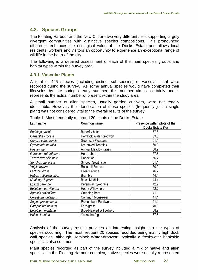
4.3.1. Vascular Plants
A total of 425 species (including distinct sub-species) of vascular plant were recorded during the survey. As some annual species would have completed their lifecycles by late spring / early summer, this number almost certainly under-represents the actual number of present within the study area.
A small number of alien species, usually garden cultivars, were not readily identifiable. However, the identification of these species (frequently just a single plant) was not considered vital to the overall results of the survey.
Table 1: Most frequently recorded 20 plants of the Docks Estate. Latin name Common name Presence within plots of the
Docks Estate (%)
Buddleja davidii Butterfly-bush 77.8
Oenanthe crocata Hemlock Water-dropwort 63.3
Conyza sumatrensis Guernsey Fleabane 61.1
Cymbalaria muralis Ivy-leaved Toadflax 60.0
Poa annua Annual Meadow-grass 58.9
Geranium robertianum Herb-robert 57.8
Taraxacum officinale Dandelion 56.7
Sonchus oleraceus Smooth Sowthistle 51.1
Vulpia myuros Rat’s-tail Fescue 50.0
Lactuca virosa Great Lettuce 46.7
Rubus fruticosus agg. Bramble 44.4
Medicago lupulina Black Medick 44.4
Lolium perenne Perennial Rye-grass 42.2
Epilobium parviflorum Hoary Willowherb 42.2
Agrostis stolonifera Creeping Bent 41.1
Cerastium fontanum Common Mouse-ear 41.1
Sagina procumbens Procumbent Pearlwort 41.1
Catapodium rigidum Fern-grass 40.0
Epilobium montanum Broad-leaved Willowherb 38.9
Holcus lanatus Yorkshire-fog 37.8
Analysis of the survey results provides an interesting insight into the types of species occurring. The most frequent 20 species recorded being mainly high dock wall species, although Hemlock Water-dropwort, typically a freshwater bankside species is also common.
Plant species recorded as part of the survey included a mix of native and alien species. In the Floating Harbour complex, native species were usually represented
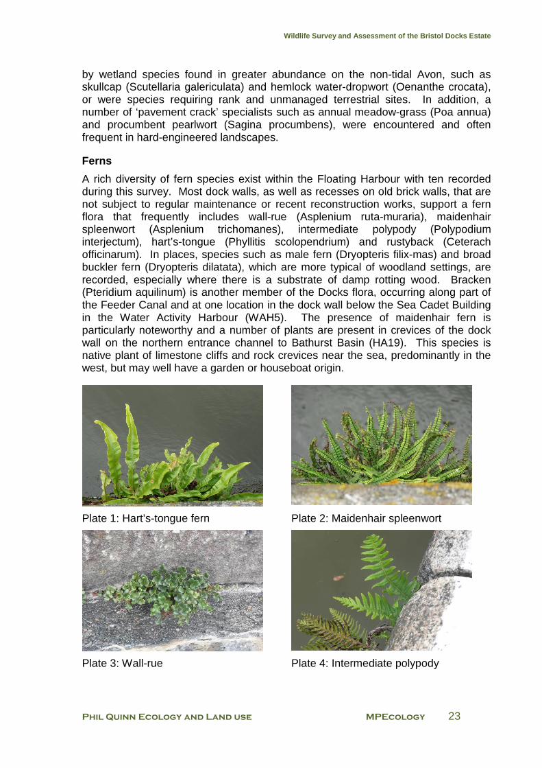
Wildlife Survey and Assessment of the Bristol Docks Estate
Phil Quinn Ecology and Land use MPEcology 23
by wetland species found in greater abundance on the non-tidal Avon, such as skullcap (Scutellaria galericulata) and hemlock water-dropwort (Oenanthe crocata), or were species requiring rank and unmanaged terrestrial sites. In addition, a number of ‘pavement crack’ specialists such as annual meadow-grass (Poa annua) and procumbent pearlwort (Sagina procumbens), were encountered and often frequent in hard-engineered landscapes.
Ferns
A rich diversity of fern species exist within the Floating Harbour with ten recorded during this survey. Most dock walls, as well as recesses on old brick walls, that are not subject to regular maintenance or recent reconstruction works, support a fern flora that frequently includes wall-rue (Asplenium ruta-muraria), maidenhair spleenwort (Asplenium trichomanes), intermediate polypody (Polypodium interjectum), hart’s-tongue (Phyllitis scolopendrium) and rustyback (Ceterach officinarum). In places, species such as male fern (Dryopteris filix-mas) and broad buckler fern (Dryopteris dilatata), which are more typical of woodland settings, are recorded, especially where there is a substrate of damp rotting wood. Bracken (Pteridium aquilinum) is another member of the Docks flora, occurring along part of the Feeder Canal and at one location in the dock wall below the Sea Cadet Building in the Water Activity Harbour (WAH5). The presence of maidenhair fern is particularly noteworthy and a number of plants are present in crevices of the dock wall on the northern entrance channel to Bathurst Basin (HA19). This species is native plant of limestone cliffs and rock crevices near the sea, predominantly in the west, but may well have a garden or houseboat origin.
Plate 1: Hart’s-tongue fern Plate 2: Maidenhair spleenwort
Plate 3: Wall-rue Plate 4: Intermediate polypody
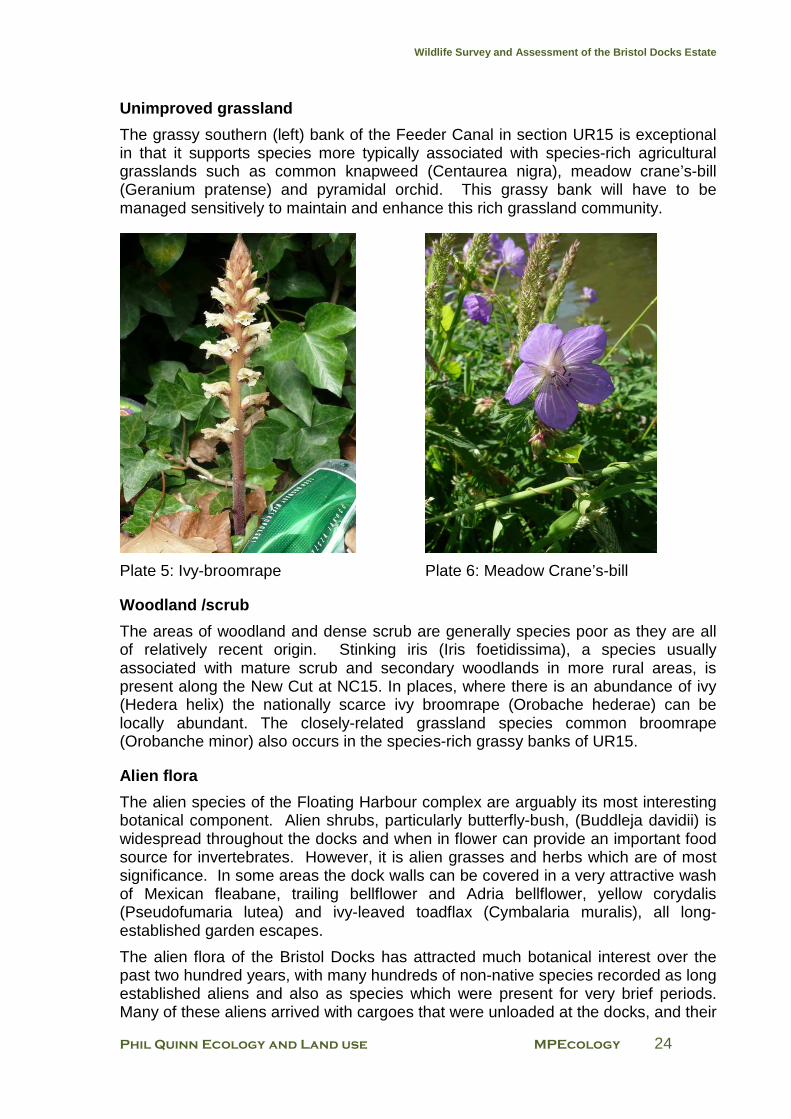
Wildlife Survey and Assessment of the Bristol Docks Estate
Phil Quinn Ecology and Land use MPEcology 24
Unimproved grassland
The grassy southern (left) bank of the Feeder Canal in section UR15 is exceptional in that it supports species more typically associated with species-rich agricultural grasslands such as common knapweed (Centaurea nigra), meadow crane’s-bill (Geranium pratense) and pyramidal orchid. This grassy bank will have to be managed sensitively to maintain and enhance this rich grassland community.
Plate 5: Ivy-broomrape Plate 6: Meadow Crane’s-bill
Woodland /scrub
The areas of woodland and dense scrub are generally species poor as they are all of relatively recent origin. Stinking iris (Iris foetidissima), a species usually associated with mature scrub and secondary woodlands in more rural areas, is present along the New Cut at NC15. In places, where there is an abundance of ivy (Hedera helix) the nationally scarce ivy broomrape (Orobache hederae) can be locally abundant. The closely-related grassland species common broomrape (Orobanche minor) also occurs in the species-rich grassy banks of UR15.
Alien flora
The alien species of the Floating Harbour complex are arguably its most interesting botanical component. Alien shrubs, particularly butterfly-bush, (Buddleja davidii) is widespread throughout the docks and when in flower can provide an important food source for invertebrates. However, it is alien grasses and herbs which are of most significance. In some areas the dock walls can be covered in a very attractive wash of Mexican fleabane, trailing bellflower and Adria bellflower, yellow corydalis (Pseudofumaria lutea) and ivy-leaved toadflax (Cymbalaria muralis), all long-established garden escapes.
The alien flora of the Bristol Docks has attracted much botanical interest over the past two hundred years, with many hundreds of non-native species recorded as long established aliens and also as species which were present for very brief periods. Many of these aliens arrived with cargoes that were unloaded at the docks, and their
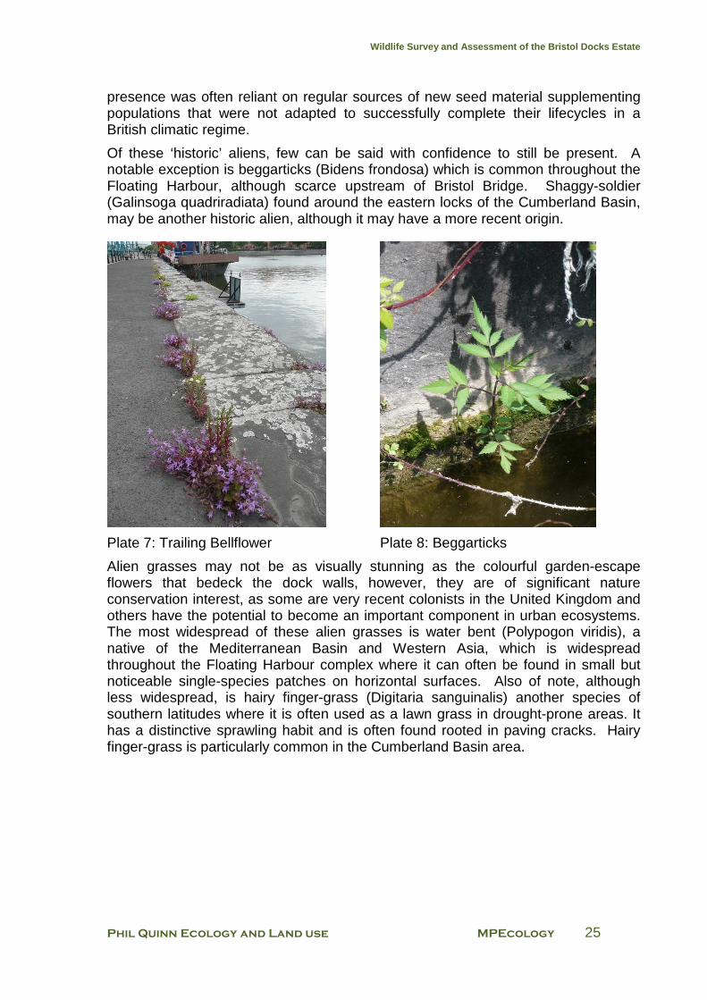
Wildlife Survey and Assessment of the Bristol Docks Estate
Phil Quinn Ecology and Land use MPEcology 25
presence was often reliant on regular sources of new seed material supplementing populations that were not adapted to successfully complete their lifecycles in a British climatic regime.
Of these ‘historic’ aliens, few can be said with confidence to still be present. A notable exception is beggarticks (Bidens frondosa) which is common throughout the Floating Harbour, although scarce upstream of Bristol Bridge. Shaggy-soldier (Galinsoga quadriradiata) found around the eastern locks of the Cumberland Basin, may be another historic alien, although it may have a more recent origin.
Plate 7: Trailing Bellflower Plate 8: Beggarticks
Alien grasses may not be as visually stunning as the colourful garden-escape flowers that bedeck the dock walls, however, they are of significant nature conservation interest, as some are very recent colonists in the United Kingdom and others have the potential to become an important component in urban ecosystems. The most widespread of these alien grasses is water bent (Polypogon viridis), a native of the Mediterranean Basin and Western Asia, which is widespread throughout the Floating Harbour complex where it can often be found in small but noticeable single-species patches on horizontal surfaces. Also of note, although less widespread, is hairy finger-grass (Digitaria sanguinalis) another species of southern latitudes where it is often used as a lawn grass in drought-prone areas. It has a distinctive sprawling habit and is often found rooted in paving cracks. Hairy finger-grass is particularly common in the Cumberland Basin area.
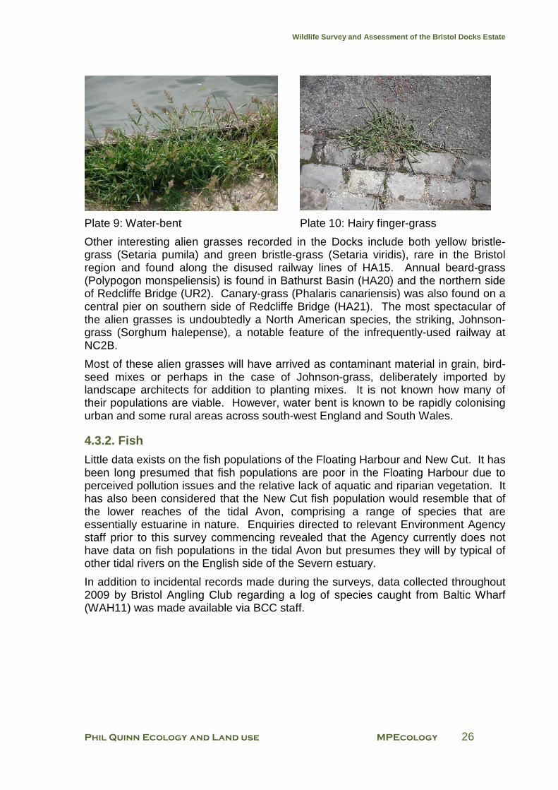
Wildlife Survey and Assessment of the Bristol Docks Estate
Phil Quinn Ecology and Land use MPEcology 26
Plate 9: Water-bent Plate 10: Hairy finger-grass
Other interesting alien grasses recorded in the Docks include both yellow bristle-grass (Setaria pumila) and green bristle-grass (Setaria viridis), rare in the Bristol region and found along the disused railway lines of HA15. Annual beard-grass (Polypogon monspeliensis) is found in Bathurst Basin (HA20) and the northern side of Redcliffe Bridge (UR2). Canary-grass (Phalaris canariensis) was also found on a central pier on southern side of Redcliffe Bridge (HA21). The most spectacular of the alien grasses is undoubtedly a North American species, the striking, Johnson-grass (Sorghum halepense), a notable feature of the infrequently-used railway at NC2B.
Most of these alien grasses will have arrived as contaminant material in grain, bird-seed mixes or perhaps in the case of Johnson-grass, deliberately imported by landscape architects for addition to planting mixes. It is not known how many of their populations are viable. However, water bent is known to be rapidly colonising urban and some rural areas across south-west England and South Wales.
4.3.2. Fish
Little data exists on the fish populations of the Floating Harbour and New Cut. It has been long presumed that fish populations are poor in the Floating Harbour due to perceived pollution issues and the relative lack of aquatic and riparian vegetation. It has also been considered that the New Cut fish population would resemble that of the lower reaches of the tidal Avon, comprising a range of species that are essentially estuarine in nature. Enquiries directed to relevant Environment Agency staff prior to this survey commencing revealed that the Agency currently does not have data on fish populations in the tidal Avon but presumes they will by typical of other tidal rivers on the English side of the Severn estuary.
In addition to incidental records made during the surveys, data collected throughout 2009 by Bristol Angling Club regarding a log of species caught from Baltic Wharf (WAH11) was made available via BCC staff.
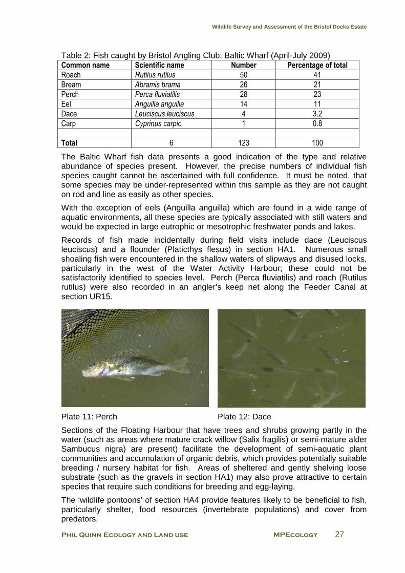
Wildlife Survey and Assessment of the Bristol Docks Estate
Phil Quinn Ecology and Land use MPEcology 27
Table 2: Fish caught by Bristol Angling Club, Baltic Wharf (April-July 2009) Common name Scientific name Number Percentage of total
Roach Rutilus rutilus 50 41
Bream Abramis brama 26 21
Perch Perca fluviatilis 28 23
Eel Anguilla anguilla 14 11
Dace Leuciscus leuciscus 4 3.2
Carp Cyprinus carpio 1 0.8
Total 6 123 100
The Baltic Wharf fish data presents a good indication of the type and relative abundance of species present. However, the precise numbers of individual fish species caught cannot be ascertained with full confidence. It must be noted, that some species may be under-represented within this sample as they are not caught on rod and line as easily as other species.
With the exception of eels (Anguilla anguilla) which are found in a wide range of aquatic environments, all these species are typically associated with still waters and would be expected in large eutrophic or mesotrophic freshwater ponds and lakes.
Records of fish made incidentally during field visits include dace (Leuciscus leuciscus) and a flounder (Platicthys flesus) in section HA1. Numerous small shoaling fish were encountered in the shallow waters of slipways and disused locks, particularly in the west of the Water Activity Harbour; these could not be satisfactorily identified to species level. Perch (Perca fluviatilis) and roach (Rutilus rutilus) were also recorded in an angler’s keep net along the Feeder Canal at section UR15.
Plate 11: Perch Plate 12: Dace
Sections of the Floating Harbour that have trees and shrubs growing partly in the water (such as areas where mature crack willow (Salix fragilis) or semi-mature alder Sambucus nigra) are present) facilitate the development of semi-aquatic plant communities and accumulation of organic debris, which provides potentially suitable breeding / nursery habitat for fish. Areas of sheltered and gently shelving loose substrate (such as the gravels in section HA1) may also prove attractive to certain species that require such conditions for breeding and egg-laying.
The ‘wildlife pontoons’ of section HA4 provide features likely to be beneficial to fish, particularly shelter, food resources (invertebrate populations) and cover from predators.
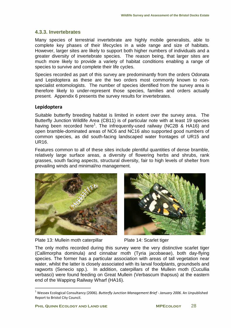
Wildlife Survey and Assessment of the Bristol Docks Estate
Phil Quinn Ecology and Land use MPEcology 28
4.3.3. Invertebrates
Many species of terrestrial invertebrate are highly mobile generalists, able to complete key phases of their lifecycles in a wide range and size of habitats. However, larger sites are likely to support both higher numbers of individuals and a greater diversity of invertebrate species. The reason being, that larger sites are much more likely to provide a variety of habitat conditions enabling a range of species to survive and complete their life cycles.
Species recorded as part of this survey are predominantly from the orders Odonata and Lepidoptera as these are the two orders most commonly known to non-specialist entomologists. The number of species identified from the survey area is therefore likely to under-represent those species, families and orders actually present. Appendix 6 presents the survey results for invertebrates.
Lepidoptera
Suitable butterfly breeding habitat is limited in extent over the survey area. The Butterfly Junction Wildlife Area (CB11) is of particular note with at least 19 species having been recorded here1. The infrequently-used railway (NC2B & HA16) and open bramble-dominated areas of NC6 and NC16 also supported good numbers of common species, as did south-facing landscaped water frontages of UR15 and UR16.
Features common to all of these sites include plentiful quantities of dense bramble, relatively large surface areas, a diversity of flowering herbs and shrubs, rank grasses, south facing aspects, structural diversity, fair to high levels of shelter from prevailing winds and minimal/no management.
Plate 13: Mullein moth caterpillar Plate 14: Scarlet tiger
The only moths recorded during this survey were the very distinctive scarlet tiger (Callimorpha dominula) and cinnabar moth (Tyria jacobaeae), both day-flying species. The former has a particular association with areas of tall vegetation near water, whilst the latter is closely associated with its larval foodplants, groundsels and ragworts (Senecio spp.). In addition, caterpillars of the Mullein moth (Cucullia verbasci) were found feeding on Great Mullein (Verbascum thapsus) at the eastern end of the Wapping Railway Wharf (HA16).
1 Wessex Ecological Consultancy (2006). Butterfly Junction Management Brief - January 2006. An Unpublished
Report to Bristol City Council.
Wildlife Survey and Assessment of the Bristol Docks Estate
Phil Quinn Ecology and Land use MPEcology 29
Odonata
In contrast to the wide distribution of most butterfly records, Odonata species were largely restricted to defined sites. By far the most notable site was the wildlife pontoon area of HA4 where both mating pairs and territorial males of azure damselfly (Coenagrion puella), blue-tailed damselfly (Ischnura elegans) and large red damselfly (Pyrrhosama nymphula) were recorded, along with at least three territorial male banded demoiselles (Calopteryx splendens). Other records are most likely to be vagrant or dispersing males. The record of white-legged damselfly (Platycnemis pennipes) from NC16 is of note as this is a more localised species, preferring slow-moving rivers and canals with good cover of emergent vegetation. It is possible that this species may be breeding in the wet woodland of UR14B.
Plate 15: White-legged damselfly Plate 16: Banded demoiselle
Other orders
The timing of the survey was such that adult grasshoppers (Orthoptera) were not recorded, although nymphs of unidentified species were seen in many areas of rank vegetation. Bees were notably abundant around flowering crucifers within the brownfield site of HA22 (behind Redcliffe Wharf) and invertebrates, were particularly associated with sunny sheltered areas with diverse vegetation.
A single rose chafer (Cetonia aurata) was also recorded at WAH5 and a single adult harlequin beetle (Harmonia axyridis succinea), an Asian ladybird species rapidly expanding its range in the United Kingdom, in HA20.
Plate 17: Rose chafer Plate 18: Harlequin beetle
Wildlife Survey and Assessment of the Bristol Docks Estate
Phil Quinn Ecology and Land use MPEcology 30
It is strongly suspected that a number of species of freshwater and brackish mollusc are present within the Floating Harbour. There is evidence from the hulls of boats being repaired in the various boatyards within the survey area that zebra mussels (Dreissena polymorpha) are present locally. This species originated on the coasts of southern Russia and has spread to many freshwater and brackish water ecosystems throughout the world as a result of maritime trade: the mussels will survive on the hulls of ships and boats and will release free-swimming young when the craft enter suitable waters. Zebra mussels will impoverish native mollusc faunas through competition and predation but may prove attractive to species of diving duck such as scaup (Aythya marila), which are mollusc feeders. A very common species of freshwater shrimp (Gammarus pulex) was also recorded within the root system of a floating plant of branched bur-reed (Sparganium erectum) found within CB3 of the Cumberland Basin.
4.3.4. Birds
This survey can only provide a snapshot of bird activity and does not reflect the value of the Docks Estate to passage or wintering birds, nor is it possible to place the Docks Estate into a wider Bristol context with regard to establishing its city wide value to breeding birds. Appendix 7 contains the detailed survey results for birds.
Two of the more notable breeding birds recorded during this survey were house martins, a large colony was found around the western end of the Water Activity Harbour, and sand martins (Riparia riparia). The sand martin colony, albeit a small one, is very important as this is only the second known breeding population of this bird in the former Avon area. Its chosen nest sites at this location, small diameter drainage holes in a wall of the Feeder Canal (UR17), may appear slightly incongruous. However, this species readily takes to artificial nest sites.
The lack of suitable scrub vegetation is a significant factor in the relative paucity of other breeding bird records. There were few observations of otherwise common passerines such as blackbird (Turdus merula) and robin (Erithacus rubecula).
Plate 19: Cormorant
Mute swans (Cygnus olor) have long been a characteristic feature of the Floating Harbour, particularly, the area between Welsh Back and Castle Park. It is estimated that there is a resident population of approximately 60 swans in the docks but with numbers swelling up to 200 birds in the winter as birds which have bred in the countryside take advantage of the slightly warmer dock waters, reliable food supplies and the relative freedom from predation. A registered charity, Friends of Bristol Swans, cares for the swans by providing food and treating any sick or injured birds.
Wildlife Survey and Assessment of the Bristol Docks Estate
Phil Quinn Ecology and Land use MPEcology 31
Waterbirds are limited in their ability to establish breeding territories and in their successful breeding attempts by the lack of sheltered nesting sites, as there are few waterside trees, shrubs or areas of riparian or emergent vegetation which these species require. Only two nesting attempts by mute swan were recorded and only five moorhen (Gallinula chlorops) breeding locations were identified, this species can be a very common breeder along watercourses with adequate vegetation. At least two broods of mallard (Anas platyrhynchos) were recorded. This species is less demanding in its nesting site requirements. However, with greater levels of vegetation and more secluded nest sites, breeding mallard would be expected to be more prolific. The site of mallard ducklings close to areas of public access is highly valued by members of the public and those living on houseboats.
The diversity and numbers of breeding birds within the Docks Estate, albeit relatively low at present, is vulnerable to small changes of management such as insensitive scrub clearance and the loss of brownfield habitat. Sensitive management of existing habitat and creation of new breeding opportunities, perhaps associated with the establishment of more floating wetlands (similar to that at HA4) would also most certainly lead to an increase in both the number and diversity of bird species. The floating wetlands have netting around their edges to prevent waterbirds trampling or grazing the vegetation. Thus it would be advantageous to have a number of nesting platforms, with covering vegetation, established amongst or adjacent to the floating wetlands.
A specific opportunity exists to encourage the Feeder Canal sand martin colony by creating artificial nest sites in proximity to existing nest chambers. (For further discussion of the potential to improve bird nesting opportunities within the Docks Estate see page 58).
Cormorants (Phalacrocorax carbo)(see Plate 19 above) long associated with the Floating Harbour, were recorded only as single birds on most survey days, with a maximum number of only two birds on any one day. This is surprising given the fish populations in the Docks. The large size and distinctive appearance of this species, coupled with it being a relatively unusual sight in a city centre, make it an important component of the wildlife experience of the city; the reasons for its apparent scarcity during the survey should be investigated.
4.3.5. Mammals
Very few mammals were recorded during the survey. A notable exception was the discovery of a major otter (Lutra lutra) sprainting site along the Feeder Canal (UR16). Otters are known to have re-colonised the Avon catchment in the early 1990s after several decades of local extinction and have been recorded on the more rural stretches of the River Frome, which eventually flows into the Floating Harbour at St Augustine’s Reach (HA6). In addition, records have originated from the Avon immediately upstream of the survey area. In recent years there have been unconfirmed reports of otter field signs from the New Cut and from within the Floating Harbour, however it is not known if these have been verified.
During this survey a number of mustelid prints were recorded in freshly exposed silt at the base of the dock wall at the western end of Cumberland Basin (CB5). The surveyors felt that they were too large for mink (Mustela vison) but the loose consistency of the mud meant that the prints were not clear enough to allow satisfactory identification as otter.
Wildlife Survey and Assessment of the Bristol Docks Estate
Phil Quinn Ecology and Land use MPEcology 32
Significant stretches of the Feeder Canal offer the levels of seclusion which otters require within their territories. The healthy fish population within the Floating Harbour complex is also a feature which is likely to be beneficial to otters establishing a regular presence within the survey area. However the hard engineered nature of much of the Floating Harbour, lack of secluded vegetation and the high levels of land-based and boat-based disturbance are likely to render much of this complex unattractive to otters other than as a feeding area.
In addition to otters there was evidence of bat species within the survey area in the form of droppings found at the base of the western gable of the Sea Cadet building (WAH5). These droppings appeared to be of a Myotis species and it is possible that a roost of this species is present in the Sea Cadet building. Furthermore a number of derelict buildings and bridges were identified as potential bat roost sites, especially for pipistrelle (Pipistrellus spp.) and Myotis species.
All built structures within the survey area must be thoroughly surveyed for evidence of bat activity before permissions are granted for their destruction, routine maintenance, restoration or conversion. (For further discussion of potential opportunities to protect and enhance the docks bat populations see page 60 and also Figure 16).
Field evidence, in the form of droppings proved the presence of brown rat (Rattus norvegicus) at various points throughout the survey area. The semi-mature woodland along sections of the New Cut would be expected to attract grey squirrel (Sciurus carolinensis), however none were recorded during the survey.
4.3.6. Reptiles and amphibians
No reptiles or amphibians were recorded during the survey. Both the Floating Harbour and the New Cut offer no breeding opportunities for amphibians and there are no smaller bodies of freshwater within the survey area that may act as amphibian breeding sites. Equally there are few areas of suitable terrestrial habitat for reptiles or amphibians away from the scrub and rank grasslands alongside the New Cut.
The Feeder Canal has the potential to support a small population of grass snake (Natrix natrix) possibly as part of a wider River Avon population. Butterfly Junction (CB11) and the disused railway line (NC4-3 / HA16) have the potential to support both slow-worms (Anguis fragilis) and common lizards (Zootoca vivipara). Dedicated surveys should be undertaken for these two species along the railway.
There are also unconfirmed records of a terrapin, possibly red-eared terrapin (Trachemys scripta), an alien species and extremely detrimental to native fauna, around Totterdown Basin (UR13 / UR14).
Wildlife Survey and Assessment of the Bristol Docks Estate
Phil Quinn Ecology and Land use MPEcology 33
5. Conclusions The Docks Estate supports an extremely rich and diverse range of species and habitats, some of which are totally unexpected within the centre of a major city.
The native and alien plants which colonise the walls and pavements of the docks, are essentially pioneer species able to exist in extreme conditions with wide fluctuations in temperature and water availability. In addition to adding texture and colour to what could otherwise be a comparatively monotone hard engineered landscape, they also support communities of invertebrates such as wild bees, which further add to the biodiversity of the city landscape. In turn the invertebrates help sustain populations of breeding birds such as moorhen and grey wagtail (Motacilla cinerea), which are attractive and often unexpected sights in the city centre.
Particular highlights of this survey have been the discovery that otters are active within the city centre, and that there is the potential for this species to breed here as long as quality otter habitat is retained and, just as importantly, more is created for them.
The presence of rare, scarce or notable species such as otter and sand martin elevate the ecological status of the Feeder Canal to a wider regional significance. The survey has also identified bat roost potential within the Floating Harbour.
With regard to other species recorded during this survey, there were few new records that enhance the ecological significance of the Docks Estate. A large number of the alien grasses recorded here are of regional significance and inherent botanical interest, however, their status as alien casuals lowers their nature conservation value.
The rich diversity and high biomass of fish, both freshwater and estuarine species, is a notable feature of the Floating Harbour and may come as a surprise to many people who live, work and relax in the city.
The New Cut is largely unmanaged and its high tidal range limits the number and quality of plant communities and species that can establish here. The saltmarsh is of exceptional value given the national decline of this community through sea level rise and coastal development. The areas of scrub and rank grassland that are occasional features along the upper banks of the New Cut are poor in plant species diversity but are often rich in invertebrate diversity. The woodlands and mature scrub along the New Cut are of limited ecological value but provide an essential screen of semi-natural vegetation within an otherwise hard-engineered urban landscape.
Although the saltmarsh of the New Cut is of great interest, perhaps the most important element of this survey has been to highlight those few areas of high quality wildlife habitat that remain in this part of central Bristol, specifically the sites and areas that have developed an exceptional wildlife value through benign neglect. Although these neglected areas are often brownfield in nature, some such as the David Abel Dockyard (WAH15) or boatyard within HA22 are very much in active use. These sites often support a very high number of plant species and were visibly of great value to a great diversity of invertebrate species.
In terms of habitat, one of the most important sites was the wet woodland of UR14B. In the more rural districts of the former Avon area this site would probably be
Wildlife Survey and Assessment of the Bristol Docks Estate
Phil Quinn Ecology and Land use MPEcology 34
designated a Wildlife Site despite its small size, due to the regional lack of wet woodlands. This site is potentially one of the most important within the survey area, given its unexpected location and species composition. Although many of the brownfield sites are of greater species diversity, and equally in need of protection and appropriate management, they are to be expected within a large urban area and such sites are intrinsically ephemeral in nature.
One of the objectives of the survey was to establish which of the more notable alien species were still present, and, if so were they still present in long-established sites. Few of the alien species noted in the 1990s appear to have been lost and many were found in the precise locations from which they have been recorded for many decades.
Further invertebrate and bat surveys are required within the Docks Estate to more fully investigate the status of these two groups. The current study only recorded incidental observations and targeted surveys were not undertaken. It is considered likely that parts of the Docks Estate will prove to be of considerable value to invertebrates, and that bat roosts will be discovered in some older buildings and possibly bridges.
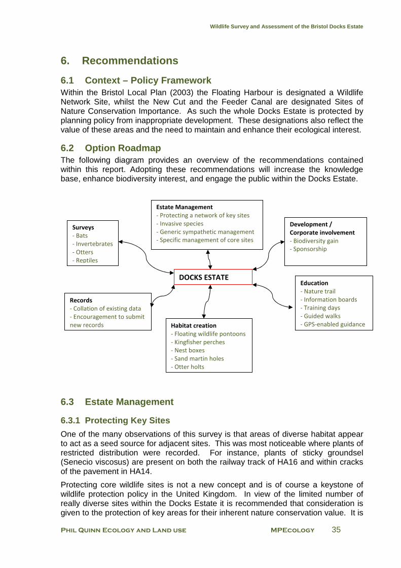
Wildlife Survey and Assessment of the Bristol Docks Estate
Phil Quinn Ecology and Land use MPEcology 35
6. Recommendations
6.1 Context – Policy Framework Within the Bristol Local Plan (2003) the Floating Harbour is designated a Wildlife Network Site, whilst the New Cut and the Feeder Canal are designated Sites of Nature Conservation Importance. As such the whole Docks Estate is protected by planning policy from inappropriate development. These designations also reflect the value of these areas and the need to maintain and enhance their ecological interest.
6.2 Option Roadmap The following diagram provides an overview of the recommendations contained within this report. Adopting these recommendations will increase the knowledge base, enhance biodiversity interest, and engage the public within the Docks Estate.
6.3 Estate Management
6.3.1 Protecting Key Sites
One of the many observations of this survey is that areas of diverse habitat appear to act as a seed source for adjacent sites. This was most noticeable where plants of restricted distribution were recorded. For instance, plants of sticky groundsel (Senecio viscosus) are present on both the railway track of HA16 and within cracks of the pavement in HA14.
Protecting core wildlife sites is not a new concept and is of course a keystone of wildlife protection policy in the United Kingdom. In view of the limited number of really diverse sites within the Docks Estate it is recommended that consideration is given to the protection of key areas for their inherent nature conservation value. It is
Surveys
- Bats
- Invertebrates
- Otters
- Reptiles
Development /
Corporate involvement
- Biodiversity gain
- Sponsorship
Habitat creation
- Floating wildlife pontoons
- Kingfisher perches
- Nest boxes
- Sand martin holes
- Otter holts
Estate Management
- Protecting a network of key sites
- Invasive species
- Generic sympathetic management
- Specific management of core sites
Records
- Collation of existing data
- Encouragement to submit
new records
Education
- Nature trail
- Information boards
- Training days
- Guided walks
- GPS-enabled guidance
DOCKS ESTATE
Wildlife Survey and Assessment of the Bristol Docks Estate
Phil Quinn Ecology and Land use MPEcology 36
envisaged that such key areas would also provide an element of connectivity within the Docks Estate and allow “seeding” of species to new habitats as they become available within the wider city-scape.
Although, the New Cut is a largely self-managing system requiring very little active management, the Floating Harbour is a very different entity. It is proposed that areas of higher nature conservation value (primarily CB11, NC2B, HA16, the brownfield of HA22, UR14B and the grassland of UR15), rather than being managed simply by benign neglect, receive an elevated status such as designation as a Local Wildlife Site within the Local Plan.
Within the wider Docks Estate there are four areas which are not only very important for their nature conservation value but also potentially vulnerable to inappropriate management. These areas should be acknowledged as requiring particular vigilance with regard to development pressures and unsympathetic management.
1. Wapping / Harbour Railway (HA16 / NC2B). The exceptional flora recorded here requires a sympathetic management regime to preserve this site’s high level of botanical diversity and species rarity.
2. Butterfly Junction (CB11).
With a few minor amendments (see page 41) the existing Butterfly Junction Management Plan2 must continue to be implemented to maintain the nature conservation value of this site.
3. Wet woodland at Totterdown Basin (UR14).
A policy of minimum interference should be adopted here to allow for the continuing high level of nature conservation interest.
4. Feeder Canal (UR15). The small area of unimproved grassland requires frequent monitoring to assess the impact of current management practices on species richness. The otter spraint site and sand martin nesting colony also need to be made known to operational staff, and contractors as and when necessary, to ensure their continued presence.
6.3.2 Invasive Species
A number of invasive plant species were identified during the course of field surveys.
The most significant of these were Japanese knotweed (Fallopia japonica) and giant hogweed (Heracleum mantegazzianum), both listed under schedule 9 of the Wildlife and Countryside Act 1981 (as amended). As schedule 9 species, it is an offence to plant or otherwise cause these species to grow in the wild. Under provisions of the Environmental Protection Act 1990 material containing these plants is classed as a controlled waste, requiring stringent disposal measures. Owners of land with
2 Wessex Ecological Consultancy (2006). Butterfly Junction Management Brief - January 2006. An Unpublished
Report to Bristol City Council.
Wildlife Survey and Assessment of the Bristol Docks Estate
Phil Quinn Ecology and Land use MPEcology 37
infestations of these species can also be held liable for any costs incurred if plant material spreads into adjacent properties.
Notwithstanding the legislative implications, many invasive species form dense stands that result in a reduction in native biodiversity interest and for this reason alone represent a threat to the local biodiversity resource.
Figure 13 (Appendix 8) indicates the location of Japanese knotweed and giant hogweed infestations within the Docks Estate. It is recommended that resources are made available to initiate a targeted programme of treatment to eradicate these species. Other invasive or potentially invasive species include Himalayan balsam (Impatiens glandulifera), buddleia (Buddleja davidii) and periwinkle (Vinca sp.). Of these, butterfly-bush in particular is controlled as part of ongoing management activities within the Docks Estate.
6.4 Generic management recommendations
6.4.1. Floating Harbour
Most of the rare or notable plants recorded within the Docks estate are annual species. These are plants which have a life span of one year or less. They require regular disturbance of (usually nutrient poor) substrates to encourage germination of their seeds. The seeds of annual plant species are often long-lived as well as being produced quickly and in abundance maximising the potential of seeds to be represented in the seed bank of even very small amounts of soil. The build up of potentially large seed banks is required because of the temporary nature of habitats commonly used by annuals including cultivated fields, gardens or disturbed ground.
Herbicide regime
At present it is understood that many sections of dock wall and associated horizontal surfaces are treated with herbicide on a comparatively regular basis (mostly two applications per year). It is likely that footpaths will continue to require herbicide treatment but it would be advantageous for areas known to support unusual species to be spared broad scale herbicide treatment and alternatively managed by hand weeding or selective weed wiping should species become problematic.
Dock walls
Furthermore it is recommended that where practicable all dock walls (vertical faces) should only be treated with herbicide in extreme situations. Not applying herbicide will allow the annual and perennial herbaceous species, which do not present a threat to the integrity of the walls, an opportunity to thrive and colonise areas which are now currently devoid of vegetation and which are strikingly low in aesthetic value. Such softening of the hard-engineered landscape, especially with the self-sowing of attractive flowering species currently thriving on sections of dock wall, will considerably enhance the visual and nature conservation experience within the Floating Harbour.
Wildlife Survey and Assessment of the Bristol Docks Estate
Phil Quinn Ecology and Land use MPEcology 38
Butterfly-bush
Buddleia or butterfly-bush is a very distinctive plant of the Docks Estate, having attractive and fragrant flowers favoured by many invertebrate species. It is particularly renowned for its attraction to butterflies thus providing an attractive wildlife spectacle for the public and other users of the Docks Estate.
The management of woody vegetation (predominantly buddleia) to prevent it damaging the integrity of the masonry is essential. However it is preferable to physically cut and spot treat the stumps of this woody vegetation with herbicide. Where treatment of the re-growth with herbicide is not possible it should be coppiced on a regular cycle (every three to four years for example). Young buddleia plants should be pulled from the walls whenever possible to prevent them from becoming established.
6.4.2 New Cut
The most important parts of the New Cut, with regard to nature conservation, are the areas of saltmarsh. It would be unfeasible and unnecessary, to attempt any management on these small linear areas which are mostly subject to tidal action and dangerous to access due to deep mud and steep slopes.
Most of the remaining areas of the New Cut support dense scrub or secondary woodland. These areas will be of value to generalist birds and invertebrates but have a very poor flora. Management options here are limited. Any dangerous trees (those with a strong likelihood of falling onto the public highway or footpaths) should be assessed and a decision made whether to fell them. It is to be noted that no demonstrably dangerous trees were noted during this survey.
Management options may include the creation of small glades within areas of dense scrub to provide habitat mosaics and small scale coppicing of some woodland areas. Allowing bramble to colonise cleared areas may generally favour wildlife, particularly small birds, by proving protective cover to nest in, as well as invertebrates drawn to its flowers and fruit. However it must be noted that the mature and semi-mature trees currently associated with the New Cut provide a strong aesthetically pleasing element to an otherwise hard-engineered landscape. A potentially more sensible option would be to retain this linear woody strip with no interference except provision of artificial refuges such as nest boxes and control of any problematic invasive species that become established.
Wildlife Survey and Assessment of the Bristol Docks Estate
Phil Quinn Ecology and Land use MPEcology 39
6.5 Site specific management recommendations In the following account of each section of the Docks estate it is presumed that the generic management recommendations outlined above (Section 6.4) will be followed unless otherwise stated.
6.5.1 Detailed Management Recommendations for Cumberland Basin
CB1: Western end of Junction Lock (west of Brunel Way)
Limit herbicide applications on the horizontal surfaces to avoid loss of hairy finger-grass and shaggy soldier populations. Investigate possibility of applying herbicide to different sections at different times to ensure all annual plant populations are not sprayed simultaneously.
Allow non-woody flora to develop on dock walls.
CB2: Cumberland Basin
Limit herbicide applications on the horizontal surfaces to avoid loss of hairy finger-grass and common amaranth populations. Investigate possibility of applying herbicide to different sections at different times to ensure all annual plant populations are not sprayed simultaneously.
Allow non-woody flora to develop on dock walls.
Investigate feasibility of establishing wildflower meadows on grassy strips on the northern and southern edges of the Basin complex. This would be best achieved by allowing growth of vegetation during the spring and summer months followed by cutting and removal of hay during late summer. Removal of material would be essential as this would help to reduce overall nutrient levels. Varying the timing of this cut may reduce the likelihood of dominance by rank grass species. Monitoring to ensure such a habitat does not become a favoured dog fouling site would be required.
CB3: South-western Cumberland Basin
Allow non-woody flora to develop on dock walls.
CB4: Cumberland Basin Entrance Lock
Allow non-woody flora to develop on dock walls. Encourage development of salt tolerant plant species on the River Avon face of the dock walls.
CB5: Cumberland Basin Sluice
Allow non-woody flora to develop on dock walls. Encourage development of salt tolerant plant species and salt marsh on the River Avon face of the dock walls. Do not treat walls or parapet with herbicides.
CB6: Amenity Planting Strip North of Smeaton Road
Manage the main grassy area under the flyover as a hay meadow with an annual cut in late August or early September and removing the cut material several days later to allow for seeds to fall from cut material. No applications of herbicides here.
Wildlife Survey and Assessment of the Bristol Docks Estate
Phil Quinn Ecology and Land use MPEcology 40
No particular management required for other areas of CB6.
CB7: Grassy Strip North of Ashmead Way
Manage the main grassy area as a hay meadow with an annual cut in late August or early September and removing the cut material several days later to allow for seeds to fall from cut material. No applications of herbicides here.
No particular management required for other areas of CB7.
CB8: Grassy Areas and Shrubberies South of McAdam Way
No particular management required here. If the shrubberies are ever cut or removed ensure this is done outside the bird nesting season (March to August inclusive) as birds are likely to be nesting here.
CB9: Grassy Road Island
Continue the current amenity grassland management regime as this appears to benefit the species composition. Never apply herbicides here.
CB10: B-Bond Car Park
Use herbicides only when necessary here although no particularly notable species are present.
CB11: Butterfly Junction
The existing Butterfly Junction Management Plan3 offers an excellent roadmap to maintaining the nature conservation value of this site. The 2009 survey visit found habitats comparable to those described by the 2006 report and significantly differing management recommendations are not proposed. However, the following suggestions are provided:
• Two invasive species were identified within habitat associated with Butterfly Junction: rosy garlic (Allium roseum) within grassland adjacent to the CREATE car park; and snowberry (Symphoricarpos albus) within shrubbery at the south-west boundary. Rosy garlic is currently invading grassland habitat while the snowberry is currently contained. It is recommended that both species are monitored and that spot treatment of herbicide is applied to plants of rosy garlic.
• Scrub and tree saplings do not appear to have been managed recently and encroachment of scrub habitat is likely to become an increasing problem if action is not carried out. It is recommended that scrub management is undertaken during the winter of 2009/2010 as described in the Butterfly Junction Management Plan.
3 Wessex Ecological Consultancy (2006). Butterfly Junction Management Brief - January 2006. An Unpublished
Report to Bristol City Council.
Wildlife Survey and Assessment of the Bristol Docks Estate
Phil Quinn Ecology and Land use MPEcology 41
6.5.2. Detailed Management Recommendations for Water Activity Harbour
WAH1: Underfall Yard
Allow wall flora to develop by restricting use of herbicides. Only use herbicides on paths when absolutely necessary.
WAH2: Underfall Yard Slipway
Allow wall flora to develop by restricting use of herbicides. Only use herbicides on paths when absolutely necessary.
This area would be suitable for the erection of kingfisher perches.
WAH3: East of Pump House
Allow wall flora to develop by restricting use of herbicides. Only use herbicides on paths when absolutely necessary.
WAH4: Old Junction Lock
Allow wall flora to develop by restricting use of herbicides. Only use herbicides on paths when absolutely necessary.
WAH5: Junction Locks East Wall (Bristol Yacht Brokerage)
Allow wall flora to develop by restricting use of herbicides. Only use herbicides on paths when absolutely necessary.
WAH6: New Junction Lock
Allow wall flora to develop by restricting use of herbicides. Only use herbicides on paths when absolutely necessary.
Note the presence of the rare alien plant narrow-leaved pepperwort (Lepidium ruderale), a plant of disturbed ground, which is located here on the north-western edge of WAH6.
WAH7: Western Poole’s Wharf
Allow wall flora to develop by restricting use of herbicides. Only use herbicides on paths when absolutely necessary.
WAH8: Poole’s Wharf Marina
Allow wall flora to develop by restricting use of herbicides. Only use herbicides on paths when absolutely necessary.
This area would be suitable for the erection of kingfisher perches.
WAH9: Eastern Poole’s Wharf
Allow wall flora to develop by restricting use of herbicides. Only use herbicides on paths when absolutely necessary.
Assess conservation value of the platforms and pontoons located here (most are of low value) and replace with similar features which are more sympathetic to nesting
Wildlife Survey and Assessment of the Bristol Docks Estate
Phil Quinn Ecology and Land use MPEcology 42
birds (in particular mallards and mute swans). Ensure new bird nesting features are moored beyond the reach of potential human disturbance.
WAH10: Mardyke
Allow wall flora to develop by restricting use of herbicides. Only use herbicides on paths when absolutely necessary.
WAH11: Baltic Wharf
Very little opportunity for nature conservation enhancement exists here given the high level of recreational water use. Some potential for floating reedbeds exists but possibly an unsuitable site for these features.
WAH12: Chatham Wharf Marina
Very little opportunity for nature conservation enhancement exists here given the high level of recreational water use.
WAH13: North of Sydney Row
Very little opportunity for nature conservation enhancement exists here given the high level of commercial activity and necessity for hard surfaces (car parking etc.) Only use herbicides when absolutely necessary.
WAH14: Albion Docks Boatyard
Very little opportunity for nature conservation enhancement exists here given the high level of commercial activity, necessity for hard surfaces (boat storage etc.) and metal shuttering dock walls. Only use herbicides when absolutely necessary.
WAH15: David Abel’s Dockyard
It is believed no herbicide treatments are applied here although vegetation clearance from dock walls is undertaken when required. This regime must be encouraged as this is one of the areas of greater botanical interest within the Docks Estate.
WAH16: Bristol Diving School Area
Very little opportunity for nature conservation enhancement exists here given the high level of commercial and recreational activity. Only use herbicides when absolutely necessary.
Wildlife Survey and Assessment of the Bristol Docks Estate
Phil Quinn Ecology and Land use MPEcology 43
6.5.3 Detailed Management Recommendations for Harbour Arena
HA1: Western Wharf
Allow wall flora to develop by restricting use of herbicides. Only use herbicides on paths when absolutely necessary.
HA2: Western Wharf Jetty
Allow wall flora to develop by restricting use of herbicides. Only use herbicides on paths when absolutely necessary. Continue to allow old partially sunken platform to remain in situ (used by nesting swans) and allow development of woody vegetation around this platform.
HA3: Gasworks Wharf
Allow wall flora to develop by restricting use of herbicides. Only use herbicides on paths when absolutely necessary.
HA4: Wildlife Pontoon
Ensure this excellent wildlife and landscape feature is well-maintained and not removed at some future time by changes in landscaping fashion.
HA5: Lloyd’s Amphitheatre area
Allow wall flora to develop by restricting use of herbicides. Only use herbicides on paths when absolutely necessary.
HA6: St Augustine’s Reach (West)
Allow wall flora to develop by restricting use of herbicides. Only use herbicides on paths when absolutely necessary. Investigate the potential for bats within the culverted section of the River Frome.
HA7: St Augustine’s Reach (East)
Allow wall flora to develop by restricting use of herbicides. Only use herbicides on paths when absolutely necessary.
HA8: Prince Street Bridge
Incorporate the rotting caissons on the eastern side of the bridge within a new wetland / bird nesting feature that will include some areas below water level, some at water level and some above water level. Fine-grade plastic mesh and / or withies may be suitable materials to construct the outer face of this feature. Plant some parts of this feature as wetland habitat (and prevent access by nesting birds to these areas) but allow natural processes and nesting birds access to other areas.
Allow wall flora to develop by restricting use of herbicides. Only use herbicides on paths when absolutely necessary.
Wildlife Survey and Assessment of the Bristol Docks Estate
Phil Quinn Ecology and Land use MPEcology 44
HA9: Mud Dock
Allow wall flora to develop by restricting use of herbicides. Only use herbicides on paths when absolutely necessary.
HA10: ‘Thekla’ Wharf
Allow wall flora to develop by restricting use of herbicides. Manage woody growth on walls by cutting and pulling (where possible). Only use herbicides on paths when absolutely necessary.
HA11: Severn Shed / River Station
Allow wall flora to develop by restricting use of herbicides. Manage woody growth on walls by cutting and pulling (where possible). Only use herbicides on paths when absolutely necessary.
HA12: Redcliffe Bridge Restaurant Car Park
Allow wall flora to develop by restricting use of herbicides. Only use herbicides on horizontal surfaces when absolutely necessary.
HA13: SS Great Britain
Allow wall flora to develop by restricting use of herbicides. Manage woody growth on walls by cutting and pulling (where possible). Only use herbicides on paths when absolutely necessary.
Erect illustrated information board outside the SS Great Britain entrance informing the public of the typical, as well as rare, plant and bird species likely to be seen in this area of the Docks Estate.
HA14: Gasferry Lane Car Park
Only use herbicides when absolutely necessary but otherwise retain a mosaic of unsprayed areas to encourage some plant growth.
HA15/15B: Wapping Dockyard to Prince’s Wharf
Allow wall flora to develop by restricting use of herbicides. Manage woody growth on walls by cutting and pulling (where possible). Only use herbicides on paths when absolutely necessary.
HA16: Wapping Railway
Continued ad hoc herbicide treatment is likely to be the best management tool here given the main nature conservation value lying in annual and biennial plant species requiring open and regularly disturbed conditions with little competition from more vigorous grasses and shrubs. Strimming this vegetation would be inadequate as it will allow grasses, shrubs and competitive herbs to develop a sward that will shade out less aggressive and more light-demanding annuals. Furthermore strimming will not provide the frequent creation of open ground conditions favoured by the notable plants recorded here; conditions that are provided by herbicide application.
However, it is recommended that herbicide treatment is applied “patchily” i.e. only where required rather than over the entire rail estate. This approach would allow
Wildlife Survey and Assessment of the Bristol Docks Estate
Phil Quinn Ecology and Land use MPEcology 45
annual and biennial species, along parts of the docks line, to complete lifecycles and produce seed even if other sections are eradicated, thereby ensuring future biodiversity.
Erect illustrated information board alongside the line informing the public of the typical, as well as rare plant species likely to be seen in this area of the Docks Estate.
This area would benefit from an invertebrate survey to inform future management.
HA17: Wapping Road
No management recommendations are suggested here as the site offers limited opportunities for nature conservation improvement.
HA18: Bathurst Wharf
Allow wall flora to develop by restricting use of herbicides. Manage woody growth on walls by cutting and pulling (where possible). Only use herbicides on paths when absolutely necessary.
HA19: Bathurst Basin (Northern Entrance)
Allow wall flora to develop by restricting use of herbicides. Manage woody growth on walls by cutting and pulling (where possible). Only use herbicides on paths when absolutely necessary.
HA20: Bathurst Basin
Allow wall flora to develop by restricting use of herbicides. Manage woody growth on walls by cutting and pulling (where possible). Only use herbicides on paths when absolutely necessary.
There is the opportunity to establish floating wetlands here as well as erecting kingfisher perches.
HA21: Redcliffe Wharf
Allow wall flora to develop by restricting use of herbicides. Only use herbicides on paths when absolutely necessary.
HA22: Redcliffe Wharf (Brownfield)
The ideal management for this site would be to retain it as a brown field site dominated by ruderal plant species; this management would require disturbance of the substrate every two to three years.
However it is acknowledged that this site offers significant development opportunities and that such a management option is not feasible. It is recommended that any development here incorporate a substantial area of green roof and that this is seeded by spreading a thin layer of seed-bearing substrate gathered from the site prior to development commencing over a crushed brick / limestone aggregate substrate (mirroring current conditions). A “Sedum-mat” would not be considered appropriate mitigation for loss of this site.

Wildlife Survey and Assessment of the Bristol Docks Estate
Phil Quinn Ecology and Land use MPEcology 46
In addition it is noted that the buildings on this site have the potential to act as bat roosts. The buildings must be subject to bat surveys prior to their demolition / conversion and bat roost features incorporated within new / refurbished structures.
Wildlife Survey and Assessment of the Bristol Docks Estate
Phil Quinn Ecology and Land use MPEcology 47
6.5.4 Detailed Management Recommendations for Upper Reaches
UR1: Welsh Back
Allow wall flora to develop by restricting use of herbicides. Only use herbicides on paths when absolutely necessary.
The relatively large number of moored boats and their associated levels of human disturbance preclude the provision of bird nesting platforms and kingfisher perches here.
UR2/2B: Redcliffe Backs
Allow wall flora to develop by restricting use of herbicides. Only use herbicides on paths when absolutely necessary.
The location is potentially suitable for the establishment of floating reedbeds /aquatic plant pontoons with incorporated bird nesting platforms.
This area would be suitable for the erection of kingfisher perches.
UR3: Castle Park
Allow wall flora to develop by restricting use of herbicides. Only use herbicides on paths when absolutely necessary. Eradication of invasive species is recommended.
The location is potentially suitable for the establishment of floating reedbeds /aquatic plant pontoons with incorporated bird nesting platforms.
The derelict concrete barges offer opportunities for wetland creation and the establishment of shrubby vegetation which would attract nesting birds.
There are also opportunities for the mooring of partially submerged logs or low platforms to provide swan roosting sites.
UR4: Former Courage Site
Allow wall flora to develop by restricting use of herbicides. Only use herbicides on paths when absolutely necessary. Eradication of invasive species is recommended.
The location is potentially suitable for the establishment of floating reedbeds /aquatic plant pontoons with incorporated bird nesting platforms.
There are also opportunities for the mooring of partially submerged logs or low platforms which will provide swan roosting opportunities.
UR5: The Watergate
Allow wall flora to develop by restricting use of herbicides.
The unexpectedly rich flora of native casuals in the flowerbed alongside the Water Gate requires a more sensitive management regime than has previously been practiced here (regular herbicide treatment). It is proposed that the bed be dug by hand in late summer / early autumn and undesirable grass weeds, which may overwhelm the site, be pulled by hand at least twice during the year. Such grasses
Wildlife Survey and Assessment of the Bristol Docks Estate
Phil Quinn Ecology and Land use MPEcology 48
would likely include couch Elytrigia repens and black grass Alopecurus myosuroides.
This management will help ensure that the very unusual causal plant flora currently at this location should continue to flourish. The notable plant species here are all annuals which require the soil to be disturbed at least once a year for their seeds to germinate and for more aggressive and more competitive species to not have an opportunity to establish. It is understood that management responsibility for this site does not lie with the Docks Estate.
UR6: ‘Bevan Brittain’ Wharf
Allow wall flora to develop by restricting use of herbicides. Only use herbicides on paths when absolutely necessary.
The location is potentially suitable for the establishment of floating reedbeds /aquatic plant pontoons with incorporated bird nesting platforms.
UR7: St Philip’s Bridge to Temple Bridge (North)
Allow wall flora to develop by restricting use of herbicides. Only use herbicides on paths when absolutely necessary.
The location is potentially suitable for the establishment of floating reedbeds /aquatic plant pontoons with incorporated bird nesting platforms.
UR8: North Quay
Allow wall flora to develop by restricting use of herbicides. Only use herbicides on paths when absolutely necessary.
The location is potentially suitable for the establishment of floating reedbeds /aquatic plant pontoons with incorporated bird nesting platforms.
UR9: Trinity Quay
Allow wall flora to develop by restricting use of herbicides. Only use herbicides on paths when absolutely necessary.
The location is potentially suitable for the establishment of floating reedbeds /aquatic plant pontoons with incorporated bird nesting platforms.
UR10: Temple Back East
Allow wall flora to develop by restricting use of herbicides. Only use herbicides on paths when absolutely necessary.
The location is potentially suitable for the establishment of floating reedbeds /aquatic plant pontoons with incorporated bird nesting platforms.
UR11: Old Ferry Station
Allow this area of scrubby vegetation to develop into an impenetrable thicket that will provide bird nesting opportunities as well as potential for otters to lay up. This will require secure fencing on the landward side and also the need to coppice or pollard sections of woody vegetation on a five year basis with one third of the site cut once every fifteen years. This location is potentially suitable for an artificial otter holt.
Wildlife Survey and Assessment of the Bristol Docks Estate
Phil Quinn Ecology and Land use MPEcology 49
Remove litter during these management operations, and at no other times, in order to reduce disturbance levels.
UR12: Avon Street (South)
Allow wall flora to develop by restricting use of herbicides. Only use herbicides on paths when absolutely necessary.
The location is potentially suitable for the establishment of floating reedbeds /aquatic plant pontoons with incorporated bird nesting platforms.
UR13: Old Post Office Depot
Allow continued development of a wild and self-seeding wetland and scrub woodland frontage. This frontage should be retained during and after any development of the adjacent old Post Office Depot complex.
UR14: Totterdown Basin (Brownfield and quays)
There is little need of any management here apart from the removal of litter. Herbicides must not be applied.
UR14B: Totterdown Basin (Wet woodland)
Allow continued development of a wild, semi-natural and self-seeding wet woodland. Remove litter once a year in the winter. No coppicing or pollarding required here. Do not dredge the area of Basin in front of the woodland as this could risk the loss of accumulated organic matter.
It is very important that this area is left to develop naturally with no human interference. It is possibly too small to allow for a nature trail to be created through it without destroying a significant part of the site.
UR15: Feeder Canal (West)
Cut the grassy strip once or twice in the spring and then allow it to grow long until late summer /early autumn when it will be mown, the arisings left for a week, and then removed from site. This management is an approximation of a hay meadow management regime and it is hoped that this will encourage the spread of the interesting grassland species here.
UR16: Feeder Canal (Central)
Ensure the wooden platform under the railway bridge is not disturbed: this is the main location for otter spraints.
Ensure minimal disturbance to the scrubby and otherwise vegetated areas on the north bank as these may prove attractive sites for otter.
Marsh Lane bridge has potential to support a Daubenton’s bat (Myotis daubentonii) roost given its structure, some cracks under the main arch and its location over a canal. Ensure that a full bat survey is undertaken on this bridge prior to any works taking place on it.
Wildlife Survey and Assessment of the Bristol Docks Estate
Phil Quinn Ecology and Land use MPEcology 50
UR17: Feeder Canal (East)
Ensure minimum interference here with regard to the tall herb and woody vegetation to be found along long sections of both banks.
Investigate the possibility of drilling more potential nest access holes for sand martins. This action should take place between October and February inclusive as this is the period when sand martins are not present in the UK and thus would not be disturbed by these works. Investigate further opportunities to create artificial nest sites locally.
Wildlife Survey and Assessment of the Bristol Docks Estate
Phil Quinn Ecology and Land use MPEcology 51
6.5.5 Detailed Management Recommendations for New Cut
NC1: West of Brunel Way
Very little management is required here. No apparent need for any herbicide applications and none are recommended here. Ensure scrub remains part of this area as it has proven value for breeding birds.
NC2: New Cut adjacent to the Create Centre
Very little management is required here. No apparent need for any herbicide applications and none are recommended here. Ensure scrub remains part of this area as it has proven value for breeding birds.
NC2B: Bristol Harbour Railway
As the current management regime appears to be ad hoc treatment when vegetation becomes problematic, there seems no reason to drastically amend practices. However, it is recommended that herbicide treatment is applied “patchily” i.e. only where required rather than over the entire rail estate. This approach would allow annual and biennial species, along parts of the docks line, to complete lifecycles and produce seed even if other sections are eradicated, thereby ensuring future biodiversity.
NC3: Riverside Garden Centre & environs
Limited opportunity to encourage nature conservation enhancement exists here. It may be advantageous to allow some areas of amenity grassland to be managed as rough grassland cut only once a year (in early autumn or early spring).
NC4: Harbour Railway Saltmarsh
No management is required for the saltmarsh.
Allow wall flora to develop by restricting use of herbicides. Only use herbicides on horizontal surfaces when absolutely necessary.
The piers of the footbridge linking Cumberland Road with Coronation Road (Greenway Bush Lane) have several cavities and cracks within the masonry that would appear suitable for pipistrelle and Myotis bat species. These features should be subject to a bat survey prior to any works taking place on them.
NC5: Coronation Road (West)
No management is required for the saltmarsh.
Allow wall flora to develop by restricting use of herbicides. Only use herbicides on horizontal surfaces when absolutely necessary.
Allow secondary woodland to continue to develop although there may be opportunities for glade creation but only if bramble and other self-seeding vegetation is allowed to develop. Glade creation will benefit a wide range of invertebrate and some bird species.
NC6: New Cut Cliff
No management is required for the saltmarsh.
Wildlife Survey and Assessment of the Bristol Docks Estate
Phil Quinn Ecology and Land use MPEcology 52
Allow wall flora to develop by restricting use of herbicides. There should be no need for herbicide applications.
Allow secondary woodland to continue to develop. Ensure the retention of a large area of bramble/ open scrub / tall herb vegetation as this is important for invertebrates.
NC7: God’s Garden
There is little opportunity to enhance this area by adopting different management techniques. The saltmarsh needs no management and there is no need to apply herbicides to any feature here.
NC8: Private car park
Allow wall flora to develop by restricting use of herbicides. Only use herbicides on horizontal surfaces when absolutely necessary.
NC9: Coronation Road (East)
No management is required for the saltmarsh.
Allow wall flora to develop by restricting use of herbicides. Only use herbicides on horizontal surfaces when absolutely necessary.
Allow secondary woodland to continue to develop although there may be opportunities for glade creation but only if bramble and other self-seeding vegetation is allowed to develop. Glade creation will benefit a wide range of invertebrate and some bird species.
NC10: Commercial Road
No management is required for the saltmarsh.
Allow wall flora to develop by restricting use of herbicides. Only use herbicides on horizontal surfaces when absolutely necessary.
NC11: Bedminster Bridge
No management is required for the saltmarsh.
Do not use herbicides on the mown grassland areas or the walls. Acknowledge that much of the nature conservation interest here arises from ad hoc disturbance to the sward by road and associated infrastructure works.
NC12: Clarence Road
No management required here.
NC13: York Road
No management is required for the saltmarsh.
Allow wall flora to develop by restricting use of herbicides. Only use herbicides on horizontal surfaces when absolutely necessary.
Allow secondary woodland to continue to develop although there may be opportunities for glade creation but only if bramble and other self-seeding vegetation
Wildlife Survey and Assessment of the Bristol Docks Estate
Phil Quinn Ecology and Land use MPEcology 53
is allowed to develop. Glade creation will benefit a wide range of invertebrate and some bird species.
NC14: Bath Bridge
No management is required for the saltmarsh.
Do not use herbicides on the mown grassland areas or the walls. Acknowledge that much of the nature conservation interest here arises from ad hoc disturbance to the sward by road and associated infrastructure works.
NC15: West of Temple Meads Bridge
No management is required for the saltmarsh.
Allow the woodland and scrub community to develop.
NC16: Wild Area East of Temple Meads
Continue ad hoc management that ensures a varied structure of plant communities with no particular emphasis on “pocket park” style management. The nature conservation interest here lies in the “rough” and unstructured plant communities with many small glades.
NC17: Disturbed Area South-east of Temple Meads
Recent disturbance (development related?) precludes any management recommendations here apart from avoidance of any actions impacting upon the saltmarsh.
NC18: Albert Road North
No management is required for the saltmarsh.
The existing neutral grassland community should be strimmed in late summer. Allow scrub woodland to continue to develop but restrict its expansion into the adjacent grassland.
NC19: Bath Road
No management is required for the saltmarsh.
Eradicate the Japanese knotweed with mechanical and chemical control.
Allow scrub woodland to continue to develop but restrict its expansion into the adjacent grassland.
NC20: Albert Road South
No management is required for the saltmarsh.
Eradicate the Japanese knotweed with mechanical and chemical control.
Allow scrub woodland to continue to develop but restrict its expansion into the adjacent grassland.
Wildlife Survey and Assessment of the Bristol Docks Estate
Phil Quinn Ecology and Land use MPEcology 54
6.6 Surveys and Biological Records
6.6.1 Collation of Existing Data
It appears likely that data relating to the Docks Estate exists in a variety of media. A search for available information and collation to further inform management within the estate is recommended as an ongoing action.
Collation of All Bird Data
It would be very useful to understand the fluctuations (if any) in the status of breeding birds within the survey area. It is understood that bird data for many parts of the city has been gathered over the past few decades. This data set should be interrogated and any patterns identified. Should there appear to be a decline in breeding birds in terms of species or numbers this should inform an investigation into what factors may be to blame.
It may also be possible that the fortunes of breeding birds have improved recently in which case it would be instructive to look at any recent changes in management and identify any positive changes. Such positive actions could then be implemented across the survey area whenever opportunities arose.
6.6.2 Surveys
This Wildlife survey and Assessment has identified the need for a number of actions that are needed to investigate little known ecological aspects of the estate. To address these the following surveys and monitoring works are suggested:
Monitoring of Otter Sprainting Sites
The active presence of Otters was confirmed by the current study although little is still known about the full use of the Docks Estate by this animal. Given that spraint recognition is a relatively simple task it is suggested that BCC boat operatives should be encouraged to keep an eye out for potential sprainting sites and to monitor known sites. All findings could then be relayed to the BCC ecologist for dissemination to all appropriate bodies (such as Avon Wildlife Trust, Environment Agency and BRERC).
Equally local people and regular boat users could be encouraged in the same fashion and in particular, to report all sightings.
Invertebrate Surveys
To help determine the nature conservation value to invertebrates of habitats within the Docks Estate it is recommended that detailed invertebrate surveys are undertaken. Three days of survey effort on each target site is recommended: once in spring/early summer, once in mid-summer, and once in late summer/early autumn.
Such surveys would help to establish the local, regional and national values of identified sites for invertebrates. It is recommended that such surveys are undertaken at:
• Brownfield sites such as HA22;
Wildlife Survey and Assessment of the Bristol Docks Estate
Phil Quinn Ecology and Land use MPEcology 55
• Railway sidings and lines including HA16 and NC2B;
• Semi-natural habitat, in particular the wet woodland of UR14B
Bat Surveys
All cracks and holes in bridges, walls and revetments should be assessed for their potential to act as bat roosts, particularly if management works are planned for such structures. The discovery of bat droppings near the Sea Cadet building of the Water Activity Harbour (WAH 5) confirms activity of this group within the Docks Estate. Specific surveys including a detailed internal / external inspection coupled with emergence and roost return surveys between May and September is recommended for :
• The Sea Cadet building (WAH5);
• Barton Hill Bridge (UR16/17).
Reptile Surveys
Few sites within the Docks Estate were considered to offer realistic potential for reptiles. However, for those sites offering potential it is recommended that survey, at an appropriate time of year, be undertaken in order to facilitate and inform future management. The following sites appear most likely to support reptile populations, particularly slow worm (Anguis fragilis) and common lizard (Lacerta vivipara):
• Wapping / Harbour Railway (HA16 / NC2B);
• Butterfly Junction (CB11).
Wildlife Monitoring of the Docks Estate
It will be useful to establish how the Docks Estate will have changed over time (five years would be an acceptable standard period). Repeat survey of all ecologically significant sites identified within this report, as well as a selection of other sites which are currently deemed of low ecological value, would provide an overview of species gain or species loss as well as an assessment of management efficacy enacted over that time span.
6.8 Habitat Creation
6.8.1 Wide-scale Habitat Creation Schemes
Wildlife Pontoons
One of the key observations made during this survey was the great success and proven biodiversity value, as well as aesthetic appeal, of the “wildlife pontoons” of section HA4. It is considered highly desirable that such measures should be replicated with immediate effect in as many parts of the Floating Harbour as possible. It is understood that events such as the Bristol Harbour Festival limit the number of locations such features could be created. However there are exceptionally barren stretches of the Docks complex (such as the Upper Reaches (UR1- 12) where mooring issues are not significant and where the hard-engineered environment is arguably dispiriting to workers and residents alike.
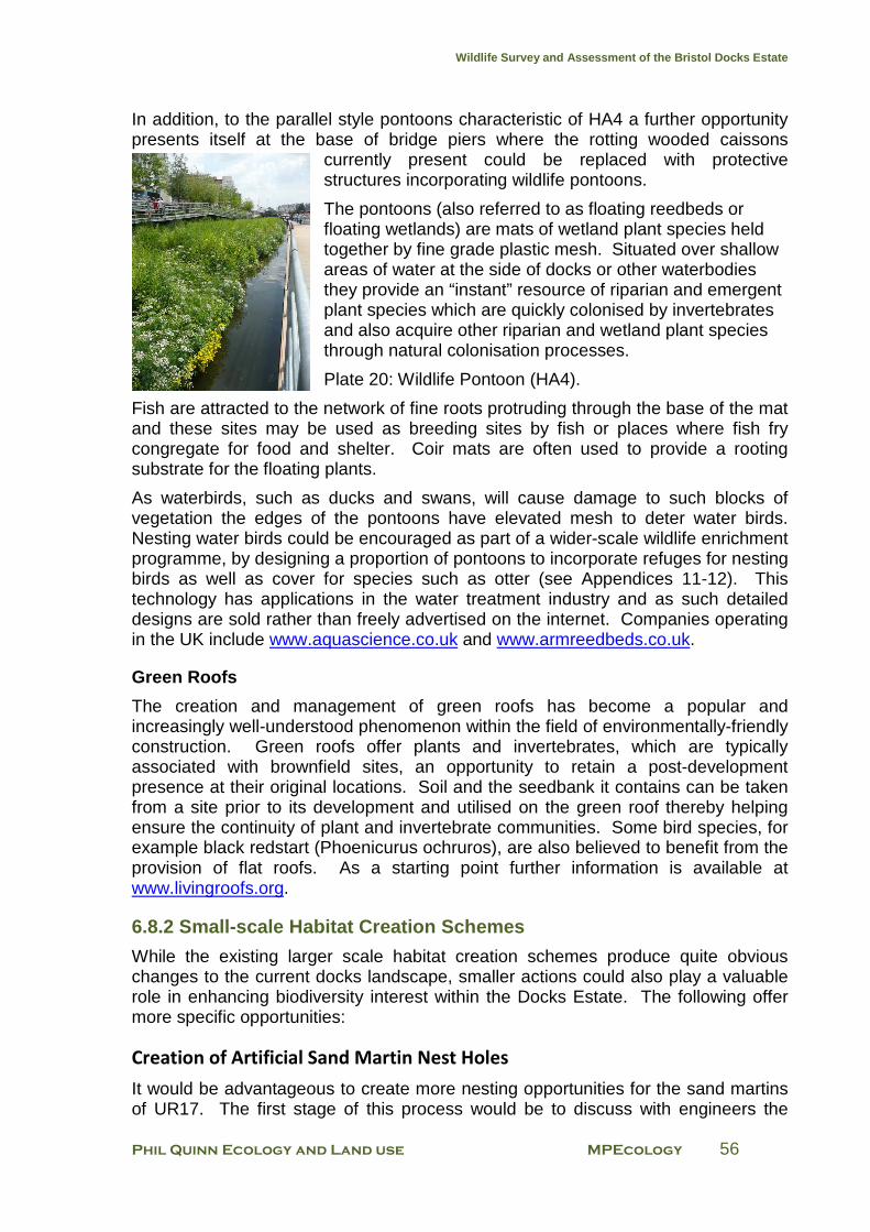
Wildlife Survey and Assessment of the Bristol Docks Estate
Phil Quinn Ecology and Land use MPEcology 56
In addition, to the parallel style pontoons characteristic of HA4 a further opportunity presents itself at the base of bridge piers where the rotting wooded caissons
currently present could be replaced with protective structures incorporating wildlife pontoons.
The pontoons (also referred to as floating reedbeds or floating wetlands) are mats of wetland plant species held together by fine grade plastic mesh. Situated over shallow areas of water at the side of docks or other waterbodies they provide an “instant” resource of riparian and emergent plant species which are quickly colonised by invertebrates and also acquire other riparian and wetland plant species through natural colonisation processes.
Plate 20: Wildlife Pontoon (HA4).
Fish are attracted to the network of fine roots protruding through the base of the mat and these sites may be used as breeding sites by fish or places where fish fry congregate for food and shelter. Coir mats are often used to provide a rooting substrate for the floating plants.
As waterbirds, such as ducks and swans, will cause damage to such blocks of vegetation the edges of the pontoons have elevated mesh to deter water birds. Nesting water birds could be encouraged as part of a wider-scale wildlife enrichment programme, by designing a proportion of pontoons to incorporate refuges for nesting birds as well as cover for species such as otter (see Appendices 11-12). This technology has applications in the water treatment industry and as such detailed designs are sold rather than freely advertised on the internet. Companies operating in the UK include www.aquascience.co.uk and www.armreedbeds.co.uk.
Green Roofs
The creation and management of green roofs has become a popular and increasingly well-understood phenomenon within the field of environmentally-friendly construction. Green roofs offer plants and invertebrates, which are typically associated with brownfield sites, an opportunity to retain a post-development presence at their original locations. Soil and the seedbank it contains can be taken from a site prior to its development and utilised on the green roof thereby helping ensure the continuity of plant and invertebrate communities. Some bird species, for example black redstart (Phoenicurus ochruros), are also believed to benefit from the provision of flat roofs. As a starting point further information is available at www.livingroofs.org.
6.8.2 Small-scale Habitat Creation Schemes
While the existing larger scale habitat creation schemes produce quite obvious changes to the current docks landscape, smaller actions could also play a valuable role in enhancing biodiversity interest within the Docks Estate. The following offer more specific opportunities:
Creation of Artificial Sand Martin Nest Holes
It would be advantageous to create more nesting opportunities for the sand martins of UR17. The first stage of this process would be to discuss with engineers the
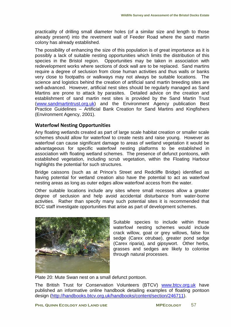
Wildlife Survey and Assessment of the Bristol Docks Estate
Phil Quinn Ecology and Land use MPEcology 57
practicality of drilling small diameter holes (of a similar size and length to those already present) into the revetment wall of Feeder Road where the sand martin colony has already established.
The possibility of enhancing the size of this population is of great importance as it is possibly a lack of suitable nesting opportunities which limits the distribution of this species in the Bristol region. Opportunities may be taken in association with redevelopment works where sections of dock wall are to be replaced. Sand martins require a degree of seclusion from close human activities and thus walls or banks very close to footpaths or walkways may not always be suitable locations. The science and logistics behind the creation of artificial sand martin breeding sites are well-advanced. However, artificial nest sites should be regularly managed as Sand Martins are prone to attack by parasites. Detailed advice on the creation and establishment of sand martin nest sites is provided by the Sand Martin Trust (www.sandmartintrust.org.uk) and the Environment Agency publication Best Practice Guidelines – Artificial Bank Creation for Sand Martins and Kingfishers (Environment Agency, 2001).
Waterfowl Nesting Opportunities
Any floating wetlands created as part of large scale habitat creation or smaller scale schemes should allow for waterfowl to create nests and raise young. However as waterfowl can cause significant damage to areas of wetland vegetation it would be advantageous for specific waterfowl nesting platforms to be established in association with floating wetland schemes. The presence of defunct pontoons, with established vegetation, including scrub vegetation, within the Floating Harbour highlights the potential for such structures.
Bridge caissons (such as at Prince’s Street and Redcliffe Bridge) identified as having potential for wetland creation also have the potential to act as waterfowl nesting areas as long as outer edges allow waterfowl access from the water.
Other suitable locations include any sites where small recesses allow a greater degree of seclusion and help avoid accidental disturbance from water-borne activities. Rather than specify many such potential sites it is recommended that BCC staff investigate opportunities that arise as part of development schemes.
Suitable species to include within these waterfowl nesting schemes would include crack willow, goat or grey willows, false fox sedge (Carex otrubae), greater pond sedge (Carex riparia), and gipsywort. Other herbs, grasses and sedges are likely to colonise through natural processes.
Plate 20: Mute Swan nest on a small defunct pontoon.
The British Trust for Conservation Volunteers (BTCV) www.btcv.org.uk have published an informative online handbook detailing examples of floating pontoon design (http://handbooks.btcv.org.uk/handbooks/content/section/246711).
Wildlife Survey and Assessment of the Bristol Docks Estate
Phil Quinn Ecology and Land use MPEcology 58
Swan Haul-outs
Swans require features either on or immediately adjacent to the water onto which they can haul out to roost or preen. There are currently few such safe features within the Docks estate including the area around Bristol Bridge where the swan population is concentrated.
It is recommended that tethered logs (split in half lengthways) or floating platforms of an alternative design are provided in this and other areas (see www.btcv.org.uk).
Kingfisher Perches Kingfishers are rarely recorded within the Docks and the lack of suitable fishing perches may be a significant factor. An opportunity exists to create kingfisher perches as part of any new structures. These perches should be between 1 metre and 2 metres above water level and can be constructed of simple small diameter horizontal bars embedded into dock walls. However, they would need to be clearly marked to avoid them being dangerous to watercraft users and should preferably have a feature such as cushioned plastic feature approximately the size of a tennis ball at their free end to avoid the risk of injury. It may be possible to incorporate kingfisher perches within artworks that have been commissioned elsewhere on the Docks Estate; these artworks would need to at least partly overhang open water. It is recommended that BCC staff discuss with Docks Estate managers to identify locations where operational works will not be negatively impacted by the erection of kingfisher perches. Commercial designs do not appear to be available because of the simplicity of the required design (i.e. a post or similar feature overhanging the water).
Cormorant Perches
Cormorants were formerly a feature of the Wapping Wharf / Industrial Museum area where up to seven at any one time could be seen sat on the higher elevations of the dockside cranes. Due to complaints from the public regarding guano being deposited by the cormorants the cranes were netted to render them unsuitable for cormorant roosting.
During this survey a maximum of two cormorants were recorded although it is not known whether cormorants exhibit a seasonal variation in their use of the Docks Estate. If numbers have decreased as a result of loss of the dockside cranes roost it would be beneficial to create new perches within the Docks Estate. Cormorants require a roosting platform which is at a discrete distance from pedestrians but they appear to be relatively comfortable with watercraft approaching within 2 metres.
The opportunity exists to potentially create an artwork incorporating a series of cormorant perches. The perches would need to incorporate flat or gently sloping areas of at least one metre square or horizontal metal poles / cable of no less that 5cm in diameter. Cormorants can often be seen perched on electricity cables along the more rural sections of the River Avon. The purpose-made perches must be sufficiently high to allow the cormorants a large area of clear airspace to take off.
Wildlife Survey and Assessment of the Bristol Docks Estate
Phil Quinn Ecology and Land use MPEcology 59
Bird / Bat Nest-boxes
The opportunity to construct and mount nest-boxes designed to accommodate birds or bats presents itself at a variety of locations within the Docks Estate. Bird boxes could include wall-mounted as well as floating designs. Wall-mounted boxes could be installed beneath bridges, buildings or some of the more substantial high walls. The most likely bird species to use these boxes would be common species such as blue tit, great tit and robin. These attractive and approachable species may be limited in their city centre distribution by the lack of suitable nesting opportunities although suitable breeding habitat for many small bird species is poor within the Floating Harbour complex. Examples of bat box design are provided by local bat groups and easily found on the internet (e.g. www.norfolk-bat-group.org.uk & www.kentbatgroup.org.uk). Companies such as Schwegler (www.schwegler-natur.de) supply a variety of hardwearing designs including free-hanging boxes and brick designs that can be incorporated into new structures.
Otter Holts
Given the presence of otters within the Docks Estate but distinct lack of cover, an opportunity to provide artificial refuges presents itself. It may be possible to create artificial holts within the hollow structures of some dock features including those at HA1 and HA5, as well as within areas of scrub, particularly UR11-13. This work should be undertaken with a minimum of discussion and with no public involvement and no publicity; to avoid any potential disturbance to otters that may utilise the holt.
Plate 21. An example of an otter holt designed in plastic (www.filcris.co.uk).
The creation of artificial otter holts is a well-established nature conservation tool and designs are easily found on the internet (for example, www.sussexotters.org and a floating design at www.staffordshirewildlife.org.uk).
6.9 Development
6.9.1 Biodiversity gain Although most of the development works within the Docks estate area have already occurred, or has been given detailed planning permission, there will still be opportunities for nature conservation gain when sites are scheduled for redevelopment. Ideally the creation of soft landscaped water frontages such as that in HA4 should be promoted. A minimum level of conservation gain should be demanded of all future developments within the survey area to ensure that not only is there no let loss of biodiversity value but that there is net conservation gain.
6.9.2 Sponsorship / Corporate Involvement The environment is increasingly taking a much higher profile in all aspects of business and many larger companies actively manage risks or impacts via an Environmental Management System (such as ISO14001). An opportunity exists to
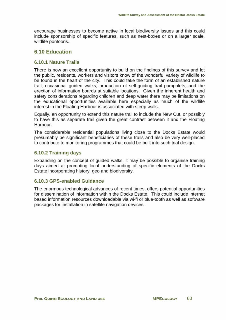
Wildlife Survey and Assessment of the Bristol Docks Estate
Phil Quinn Ecology and Land use MPEcology 60
encourage businesses to become active in local biodiversity issues and this could include sponsorship of specific features, such as nest-boxes or on a larger scale, wildlife pontoons.
6.10 Education
6.10.1 Nature Trails
There is now an excellent opportunity to build on the findings of this survey and let the public, residents, workers and visitors know of the wonderful variety of wildlife to be found in the heart of the city. This could take the form of an established nature trail, occasional guided walks, production of self-guiding trail pamphlets, and the erection of information boards at suitable locations. Given the inherent health and safety considerations regarding children and deep water there may be limitations on the educational opportunities available here especially as much of the wildlife interest in the Floating Harbour is associated with steep walls.
Equally, an opportunity to extend this nature trail to include the New Cut, or possibly to have this as separate trail given the great contrast between it and the Floating Harbour.
The considerable residential populations living close to the Docks Estate would presumably be significant beneficiaries of these trails and also be very well-placed to contribute to monitoring programmes that could be built into such trial design.
6.10.2 Training days
Expanding on the concept of guided walks, it may be possible to organise training days aimed at promoting local understanding of specific elements of the Docks Estate incorporating history, geo and biodiversity.
6.10.3 GPS-enabled Guidance
The enormous technological advances of recent times, offers potential opportunities for dissemination of information within the Docks Estate. This could include internet based information resources downloadable via wi-fi or blue-tooth as well as software packages for installation in satellite navigation devices.
Wildlife Survey and Assessment of the Bristol Docks Estate
Phil Quinn Ecology and Land use MPEcology 61
Appendix 1 Detailed Survey Results for Cumberland Basin
CB1: Western end of Junction Lock (west of Brunel Way)
The western end of the Junction Lock complex is divided from the main complex (WAH4-WAH6) by the swing bridge of Brunel Way (A3029). The built structure of this area is similar to that of the corresponding sections of WAH4-WAH6; however the horizontal surface on the northern side of this section consists of paving bricks and the cracks between these provide an ideal habitat for hairy finger-grass (Digitaria sanguinalis), which is common here. A small population of the alien plant shaggy soldier (Galinsoga quadriradiata) also occurs.
The north facing walls of the locks are relatively rich in herbaceous plants, particularly ferns with hart’s-tongue (Phyllitis scolopendrium) and wall-rue (Asplenium ruta-muraria) both common.
CB2: Cumberland Basin
This large waterbody supports a diverse but somewhat sparse plant community on its tight-fitting masonry walls. This section includes the area of Cumberland Basin under Plimsoll Bridge as far west as the easternmost lock gate (the north-facing wall here supports the most diverse botanical interest of any of the walls within Cumberland Basin in terms of species and numbers of plants). Native wetland species such as gipsywort (Lycopus europaeus), and alien species such as Guernsey fleabane (Conyza sumatrensis) are recorded here. However the proximity of this section to the tidal River Avon is apparent in a slight saline influence, with the presence of species such as buck’s-horn plantain (Plantago coronopus) and sea couch (Elytrgia aetherica).
On both the northern and southern sides of the Basin there are brick-paved surfaces close to the Basin walls that become mown grass closer to the adjacent public highways.
On the northern side hairy finger-grass is dominant within the cracks of the paved area and also between this paved area and the mown grass. Also of note here are scattered plants of common amaranth (Amaranthus retroflexus), an alien species uncommon in the Bristol region.
A significant part of the southern side of the Basin was not accessible at the time of survey due to construction works, however, the horizontal surfaces here appeared to be relatively species-poor with the exception of a small population of Babbington’s poppy (Papaver dubium lecoqii) towards the west.
CB3: South-western Cumberland Basin
Structurally part of Cumberland Basin, this small area is partially divided from the main body of the Basin by a substantial wooden wall. This area has a relatively rich flora growing on the north-facing Basin wall with the typical range of ferns, native wetland species and alien casuals. A plant of branched bur-reed (Sparganium
Wildlife Survey and Assessment of the Bristol Docks Estate
Phil Quinn Ecology and Land use MPEcology 62
erectum) was recorded floating in the water here, presumably having floated down from a location upstream on the Avon.
CB4: Cumberland Basin Entrance Lock
An active lock on the north-western side of the Basin, the plant species in this area are strongly influenced by the tidal River Avon, particularly on the outer lock gates; the inner lock is rich in fern species. The lock is constructed from massive masonry blocks with large granite caps. This section also includes a narrow strip of flat surface on the north side and a much larger area of mainly tarmac on the south side.
CB5: Cumberland Basin Sluice
This is the outer edge of the Cumberland Basin complex and forms part of the eastern bank of the River Avon. The massive masonry walls continue around the length of the Basin edge but there are significant depositions of silt at the base of these walls where a saltmarsh plant community has developed. Mustelid prints (most probably otter) were recorded on the silt immediately below the sluice.
CB6: Amenity Planting Strip North of Smeaton Road
A thin strip of species-rich grassland partly beneath the Ashmead Way fly-over, however, there is sufficient natural light for the whole of this area to support herbs and grasses. The western half is heavily shaded and supports a diverse sward, whilst the eastern half is not shaded and is dominated by coarse grasses. The diversity of species here suggests that the plant community may, at least in part, originate from a deliberate sowing programme or the introduction of turves from a threatened grassland site. Particularly notable species include common spotted orchid (Dactylorhiza fuchsii), field wood-rush (Luzula campestris), quaking grass (Briza media) and pignut (Conopodium majus). Small skipper (Thymelicus sylvestris) was recorded here.
Two smaller isolated plots towards the west have been planted with trees and shrubs but were considered of lower conservation value.
CB7: Grassy Strip North of Ashmead Way
Akin to CB6, although parts of this grassy strip dotted with maples (Acer sp.) support relatively rank grassland, species-rich sward is present towards the east and includes common bird’s-foot-trefoil (Lotus corniculatus), ladies-bedstraw (Galium verum), lesser stitchwort (Stellaria graminea) and a white-flowering variety of bugle (Ajuga reptans). In addition, a single plant of an alien brome, provisionally identified as Californian Brome (Bromus carinatus), is present beside a path midway along the strip.
CB8: Grassy Areas and Shrubberies South of McAdam Way
This section consists of two small separate areas. The northernmost area is a tightly mown grass-dominated sward. The southernmost area comprises this community and also a large block of planted alien and native trees and shrubs. The only
Wildlife Survey and Assessment of the Bristol Docks Estate
Phil Quinn Ecology and Land use MPEcology 63
botanical interest in this section are small populations of wild madder (Sharardia arvensis), an annual of disturbed ground and usually associated with arable fields. The shrubbery supported a blackbird nest with two well-grown juveniles nearby.
CB9: Grassy Road Island
This semi-improved neutral grassland plot surrounded by roads and buildings supports an unusual assemblage of plants. The grassland is located at the western end of the Brunel Way road system and managed by mowing. The well-developed sward is bordered by planted native and alien shrubs. Species of note include relatively large populations of heath speedwell (Veronica officinalis,), bugle (Ajuga reptans) and bird’s-foot trefoil (Lotus corniculatus), along with scattered specimens of pignut and lesser stitchwort (Stellaria graminea). The species composition suggests a mild acidic substrate.
CB10: B-Bond Car Park
The car park sports a tamacadam finish devoid of vegetation but is occasionally punctuated by landscape trees of Italian alder (Alnus cordata). It is the soil at the bases of the trees that support botanical interest within the plot. Both planted garden species such as love-in-a-mist (Nigella damascena) as well as casual ruderals including fern-grass (Catapodium murinum), wall lettuce (Mycelis muralis) and perennial wall-rocket (Diplotaxis tenuifolia) are present.
CB11: Butterfly Junction
The aggregate associated with rail infrastructure is still present but now largely vegetated except along a single very infrequently used line. Habitat within the plot grades from the sparse ephemeral vegetation associated with dry stony ground to grassland and peripheral scrub. The area supports an array of butterfly species but many other invertebrate species as well as breeding birds and reptiles are likely to be present.
Stony ground supports abundant rat’s-tail fescue (Vulpia myuros) as well as fern-grass (Catapodium rigidum), black medick (Medicago lupulina) and hop trefoil (Trifolium campestre). Much of the grassland habitat is dominated by tall fescue (Festuca arundinacea) but is relatively rich with many other species interspersed including grey sedge (Carex divulsa), flattened meadow-grass (Poa compressa) and much less frequently narrow-leaved meadow-grass (Poa angustifolia). Towards the western end beside the CREATE centre car park rosy garlic (Allium roseum) is invading. Midway through the plot an area of wet grassland supports hard-rush (Juncus inflexus), tufted hair-grass (Deschampsia cespitosa), Yorkshire-fog (Holcus lanatus), glaucous sedge (Carex flacca) as well as spiked sedge (Carex spicata). Peripheral scrub is mixed, towards the east bramble is dominant but locally, butterfly-bush (Buddleja davidii) is frequent. Other common native woody species as well as garden escapes are also present.
Wildlife Survey and Assessment of the Bristol Docks Estate
Phil Quinn Ecology and Land use MPEcology 64
Appendix 2
Detailed Survey Results for Water Activity Harbour
WAH1: Underfall Yard
A north facing dock wall constructed from sandstone masonry with a concrete top. There is an active boatyard here and also the moorings for the Bristol City Harbour craft.
Plants are sparse here and largely restricted to the vertical dock wall and adjacent concrete cap. Notable species include skullcap (Scutellaria galericulata), black spleenwort (Asplenium adiantum-nigrum), and remote sedge (Carex remota); the maritime form of curled dock (Rumex crispus littoreus) is occasional here. The horizontal surfaces associated with this area are comprised of tarmac, support very few plants (mostly common weed species) and hold no conservation value. The only species of note on the flat surfaces is the increasingly common alien grass water bent (Polypogon viridis).
WAH2: Underfall Yard Slipway
A small stone-lined slipway used to haul out boats for repair and to launch craft. It has a north-east to south-west axis and is built of the same materials as WAH1.
Plants are again mainly restricted to the vertical surfaces of the dock walls and are very similar to those found in WAH1. Small populations of biting stonecrop (Sedum acre) are notable on both the vertical and flat surfaces towards the north-eastern end of this area. Many small fish were present in shoals here.
WAH3: East of Pump House
A short length of east-facing dock wall with semi-derelict flat surfaces to the west. The dock walls are still masonry but the flat surfaces are a mix of hard core, concrete and tarmac. There is a diverse ruderal and ephemeral /short perennial community on the flat surfaces, whilst the dock walls support a similar species composition to WAH1 & WAH2. Two of the most commonly recorded alien plants recorded in the dock; water bent and Guernsey fleabane, are found here.
WAH4: Old Junction Lock
The plot comprises the southernmost lock between Cumberland Basin and the Water Activity Harbour. The lock has a north-west to south-east axis and is no longer in use. The walls are of masonry, the north facing wall has a particularly luxuriant and species-diverse flora that includes a mix of native wetland species and alien species such as beggarticks (Bidens frondosa). On the flat surfaces of WAH4 (up to the buildings on both north and south sides) there is a rich flora that includes the unusual alien species shaggy soldier. The flat surfaces are subject to occasional applications of herbicide sprays.
Wildlife Survey and Assessment of the Bristol Docks Estate
Phil Quinn Ecology and Land use MPEcology 65
WAH5: Junction Locks East Wall (Bristol Yacht Brokerage)
This is the east-facing dock wall between the Old and New Junction Locks. It is constructed from Carboniferous sandstone masonry and the flat surfaces are largely tarmac. It includes the curtilage of the Bristol Sea Cadets building. There is a jetty here leading onto a series of pontoons where craft associated with Bristol Yacht Brokerage Ltd are moored.
The section of dock wall associated with the Sea Cadets building includes several alders (Alnus glutinosa) between one and five years old, in addition to a small clump of bracken (Pteridium aquilinum). Beggar-ticks is also recorded here. It is clear that woody vegetation must be removed from this area to prevent structural damage to the walls, however, the diverse herbaceous plant community should not be treated with herbicide.
At least three active house martin (Delichon urbica) nests were recorded under the eaves of the Sea Cadets building. On the western side of this building several fresh bat droppings (possibly Myotis species) were recorded.
WAH6: New Junction Lock
The northernmost of the two locks running between Cumberland Basin and the Water Activity Harbour with an east to west axis. The lock walls are of tightly fitted masonry with large granite blocks forming the cap. Residential buildings and a public house form the northern boundary of this area. At the time of survey there was much construction work taking place on the northern side of this lock and a new set of lock gates had recently been installed.
Despite the recent construction works, the northern (south-facing) lock wall is quite rich in plants and has a good species diversity. The opposing lock wall is less diverse. Hairy-finger-grass is present in small quantity on the flat surfaces on the northern side of the lock. Also of note is a single plant of narrow-leaved pepperwort (Lepidium ruderale), a plant of disturbed ground, which is rare in the Bristol region. This plant is located on the north-western edge of WAH6.
WAH7: Western Poole’s Wharf
Mexican fleabane (Erigeron karvinskianus) and Adria bellflower (Campanula portenschlagiana) are very common here and form an attractive feature along the dock walls. Other species found here are typical of those found around the western end of the Water Activity Harbour, although marsh yellow-cress (Rorippa plaustris) is quite frequent on the flat surfaces. Small populations of yellow water-lily (Nuphar lutea) are also present. WAH7 is bisected by the entrance to Poole’s Wharf Marina (WAH8); this entrance is crossed by a footbridge.
WAH8: Poole’s Wharf Marina
A small concrete-lined dock surrounded on all but the south side by residential properties with small front gardens. Occasional unidentified garden escapes have established here. On the eastern side of this dock there is a small band of planted lavenders (Lavandula sp.) between the top of the dock wall and the flat surface of the adjacent footpath. Yellow water-lily is common at the northern end of the dock.

Wildlife Survey and Assessment of the Bristol Docks Estate
Phil Quinn Ecology and Land use MPEcology 66
WAH9: Eastern Poole’s Wharf
Much of the dock wall here consists of metal shuttering with little opportunity for plant growth; however there are sections of old masonry dock wall. The horizontal surfaces here had been treated with herbicide prior to the survey and thus few species were recorded away from the dock wall. The main biodiversity interest in this section centres on a number of floating pontoons tied to the dock wall, two of which are believed to have been constructed as part of the Festival of Nature in 2008. The majority of plant species recorded in this section are found on the pontoons. A female mallard with a brood of nine ducklings were present on and around the pontoons at the time of survey.
WAH10: Mardyke
The masonry dock walls of this section support a relatively poor assemblage of sparsely distributed plants. The main species of interest is flattened meadow-grass (Poa compressa), which is present in small numbers towards the eastern end of this section. The footpath is comprised of brick paving and there is little plant growth here, particularly as this path had been sprayed with herbicide prior to the survey.
WAH11: Baltic Wharf
A long stretch on the southern side of the Water Activity Harbour, this section consists of gently shelving hard surfaces and flights of steps leading down to the water’s edge, with a broad footpath to the south running parallel with the edge of the dock. Although sparsely vegetated (with the exception of some young planted trees and shrubs) there was a wide range of species recorded. However, the majority were from the dock edge and often very scattered. This section has low nature conservation value.
WAH12: Chatham Wharf Marina
The largest of the marinas within the docks, this section consists mostly of a large area of pontoons. The dock walls are of sheet metal piling and consequently there is very little plant growth here although small holes in the piling do support individual plants such as beggarticks and hemlock water-dropwort (Oenanthe crocata).
WAH13: North of Sydney Row
This plot consists of commercial units, car parks and warehouses with open ground dominated by concrete and tarmac. Degraded tarmac supports occasional and sparse cover of grasses, such as rat’s-tail fescue, but open ground is largely devoid of vegetation. Planting beds and rough ground beside buildings support many of the species recorded. One of the species recorded, Lucerne (Medicago sativa ssp. Sativa) a commonly planted agricultural species was recorded nowhere else in the Docks Estate.
WAH14: Albion Docks Boatyard
This active boatyard (mostly repairs to old craft) sits approximately 5m above water level and has a horizontal surface of gravel and loose aggregate. There are some
Wildlife Survey and Assessment of the Bristol Docks Estate
Phil Quinn Ecology and Land use MPEcology 67
species associated with wetland such as beggarticks (a particularly extensive population) on the edges of this boatyard. However, the majority of the botanical interest lies with ruderal species and other casual species of dry ground. Of particular interest, is a large (though scattered) population of the alien crucifer eastern rocket (Sisymbrium orientale), which in the UK is largely restricted to urban areas and in particular ports. Vervain (Verbena officinalis) and weld (Reseda luteola) are also found here and are unusual species in such an urban setting.
Where boat hulls have been scraped clean there are often piles of zebra mussel shells.
WAH15: David Abel’s Dockyard
The dockyard hosts one of the few truly industrial maritime industries left within the Docks estate. A long and striking, sunken rectangular dry-dock sandwiched between the Albion Docks Boatyard and the SS Great Britain complex supports active boat-building (with the hulks of two steel vessels under construction during the survey visit). A leaking lock gate holds back metres of water sitting in the adjacent dock and occasional flooding to allow finished vessels to be launched, seeds the feature with semi-aquatic plant species.
Sediment and damp stonework at the base of the dry-dock supports abundant beggarticks as well as marsh yellow-cress (Rorippa palustris), celery-leaved buttercup (Ranunculus sceleratus), hemlock water-dropwort, curled dock and great willowherb (Epilobium hirsutum). The structure is constructed of large stone blocks and the steeply stepped sides of the dry-dock support a variety of species including many ferns. A pair of grey wagtails was observed feeding at the base of the dock during the visit. Above the dry-dock the feature is surrounded by a wide strip of compacted earth/aggregate supporting a variety of ruderal species as well as buddleia scrub. Adjacent to the compound of the SS Great Britain deeper soils even support bracken. Ground cover with dense ivy also supports ivy-broomrape.
WAH16: Bristol Diving School Area
A series of buildings (mostly recreational and commercial) situated between David Abel’s Dockyard and Gasferry Road. Most of the area not covered by buildings consists of hardstanding with a thin covering of casual and ruderal plant species. However around the boundaries of individual properties there are often thin strips of semi-mature trees; sycamore (Acer pseudoplatanus) and buddleia (Buddleia davidii) are the commonest species. A large population (at least 40 spikes) of the nationally scarce ivy broomrape (Orobanche hederae) is present at the base of a large brick wall, which is the southern side of a substantial derelict building with its frontage on Gasferry Road.
Wildlife Survey and Assessment of the Bristol Docks Estate
Phil Quinn Ecology and Land use MPEcology 68
Appendix 3
Detailed Survey Results for Harbour Arena
HA1: Western Wharf
This area has recently been developed with a large residential block immediately to the north of the dock and a broad tarmac path between the housing and the dock wall. The original dock wall survives but the pavement area has been built out over the water on a framework of concrete struts, forming a series of box-like units open on all but the upper side (which supports the pavement). Large wooden beams run just in front of the concrete structure and there is a wooden jetty in front of these running parallel to the dock edge. Within the concrete structure there is a gently sloping submerged gravel bed where many fish (including clear views of a flounder were observed; this area would appear to offer excellent breeding conditions for fish.
There is a relatively diverse flora in this section, mostly on the wooden beams in front of the concrete structure. Some plants grow within the concrete structure but are limited by the relatively low levels of natural illumination. There is a very poor flora on the pavement area.
HA2: Western Wharf Jetty
A small section centred on a semi-mature crack willow (Salix fragilis)’ the largest tree in the western part of the docks, in addition to a semi-mature dying alder (Alnus glutinosa). This willow grows in a small backwater and there is an accumulation of flotsam, along with an old pontoon that is now supporting a luxuriant flora and a nest of a pair of mute swans (Cygnus olor). This swan’s nest attracted much interest from the public who were anticipating the eggs hatching.
Another old pontoon supports a semi-mature crack willow as well as some buddleja scrub and emergent plants such as hemlock water-dropwort. A moorhen (Gallinula chloropus) was heard calling from within this vegetation and it is probable that this species was nesting here.
The structure of the dock here is old weathered masonry. The top of the dock wall supports a rich flora including wild carrot (Daucus carota) and purple toadflax (Linaria purpurea); ferns such as rustyback (Ceterarch officinarum) and wall-rue are common here. Round-leaved crane’s-bill (Gernaium rotundifolium), an uncommon plant species, was also recorded here.
HA3: Gasworks Wharf
Centred on a large embayment, this area appeared to be still under construction at the time of survey; a wide wooden pontoon was being created within the inner edge of the embayment and wooden hoardings were present on the landward side. A paved footpath ran between the hoardings and the pontoon. The dock wall here is largely concrete, although there are sections of old masonry wall. Beggarticks is locally common here but otherwise botanical interest is relatively low.
Wildlife Survey and Assessment of the Bristol Docks Estate
Phil Quinn Ecology and Land use MPEcology 69
HA4: Wildlife Pontoon
This is another area of recent development, however, in marked contrast to HA1 particular effort has been applied to creating a more naturalistic riverside environment between the residential properties to the north and the dock to the south. Progressing south from the residential development there is a series of terraces planted with trees and shrubs with walkways running parallel to the dock. These terraces lead down to the water’s edge, where there is a long partially submerged pontoon full of emergent (and mostly native) plants. Common reed (Phragmites australis) is dominant and hemlock water-dropwort is abundant, with gipsywort, a monkeyflower (Mimulus sp.) (non-native), flag iris (Iris pseudacorus), great willowherb (Epilobium hirsutum), marsh marigold (Caltha palustris) and many others also present. This luxuriant vegetation and the flooded substrate attract large numbers of damselflies, with mating pairs of azure blue (Coenagrion puella), large red (Pyrrhosoma nymphula), blue-tailed (Ischnura elegans) and banded demoiselle (Calopteryx splendens) all recorded.
HA5: Lloyd’s Amphitheatre area
A particularly biodiversity-poor stretch of the docks with high concrete dock walls and herbicide-sprayed paved areas to the north; several large boats are berthed here. There are only two areas of minor interest; the first is found at the southernmost tip of this section, where there are small pockets of ferns growing in cracks in the dock walls. The strikingly unusual liverwort (Marchantia polymorpha) is found here. The second area is on the north-eastern side of the amphitheatre where a thin band of unusual casual plant species (mostly aliens) is found. These include eastern rocket (Sisymbrium orientale), weld, sticky groundsel (Senecio viscosus) and Oxford ragwort (Senecio squalidus).
Several weeks after each application of herbicide a casual plant flora attempts to establish amongst the paving of the Lloyd’s Amphitheatre area; rue-leaved saxifrage (Saxifraga tridactylites), fern grass (Catapodium rigidum), biting stonecrop, and annual meadow-grass (Poa annua) are the main species here.
HA6: St Augustine’s Reach (West)
This stretch occupies the western side of the lower course of the River Frome, which flows into this section of dock through a metal grille at the northernmost end of HA6. The dock walls are of masonry and the cobbled horizontal surfaces are largely given over to leisure and restaurant facilities. There are pontoons and moorings here. Although plants are quite frequent on the dock walls here they do not occur in any abundance, and, with the exception of a small clump of skullcap, there were no notable species recorded. Rue-leaved saxifrage is occasional on the interface between the edge of the cobbled path and the top of the dock wall.
HA7: St Augustine’s Reach (East)
This is the eastern side of the dock where the River Frome flows into the Floating Harbour. There are barges moored parallel with the dock walls, which are constructed from masonry. The horizontal surfaces are mostly cobbled pavements, which are very poor in botanical interest as they appear to be regularly treated with
Wildlife Survey and Assessment of the Bristol Docks Estate
Phil Quinn Ecology and Land use MPEcology 70
herbicide. The dock walls support a similar species composition to that on the western side of St Augustine’s Reach, however, there are fewer plants on the eastern side with only the middle section approaching the quality of the opposite wall.
HA8: Prince Street Bridge
The western side of this small swing bridge is relatively poor in botanical interest with few plants recorded here. The eastern side is of more interest. Here there is a defunct and mostly rotten circular wooden caisson, which was originally constructed to prevent boats colliding with the structure of the bridge. This caisson has open water in its centre and there are numerous plants growing on the rotten woodwork. On the pier of the bridge there is a small population of henbit (Lamium amplexicaule), an unusual native species normally associated with cultivated ground. Skullcap is locally common here and there is a small population of broad buckler fern (Dryopteris dilatata).
HA9: Mud Dock
An old masonry wall forms the edge of the dock here. There is small area of rubble and mud at the foot of the wall on the northern edge of this area and there appears to be some boat repair works here. A notable feature of this section is the abundance of young alders in cracks in the masonry, both the native alder and the Italian alder (Alnus cordata). The latter species has self-seeded prolifically from mature planted trees in the car park immediately to the north. The native alders are dying from Phytophthora, a water-borne fungal disease widespread in the UK. There is quite a diverse flora on the dock walls here, including a good population of the liverwort (Marchantia polymorpha). The sandstone masonry allows the presence of bracken here.
HA10: ‘Thekla’ Wharf
A short length of botanically very impoverished dock wall of neat masonry and a concrete cap. The nightclub boat ‘Thekla’ is moored here and obstructs natural illumination from most of the wall. There is some self-sown Italian alder.
HA11: Severn Shed / River Station
A short section of dock wall fronting the two adjacent restaurants of Severn Shed and The River Station. The wall is constructed from masonry and there is a berth partly hidden beneath the River Station restaurant, where the former Redcliffe Ferry would dock.
HA12: Redcliffe Bridge Restaurant Car Park
This is a small area of brown field land currently used as a car park by staff from the adjacent restaurant. The outer edges of the car park, at the base of the adjacent road and on the masonry dock walls, support quite a rich ruderal and casual plant flora including the garden escape (Verbena bonariensis). Of particular note is a relatively large population of the alien grass water bent.
Wildlife Survey and Assessment of the Bristol Docks Estate
Phil Quinn Ecology and Land use MPEcology 71
HA13: SS Great Britain
One of the major tourist attractions in Bristol, this site includes a section of old un-restored masonry dock wall, which may be considered the most botanically diverse of any of the dock walls surveyed. In contrast the flat surfaces of this site (around the ship and associated buildings) are almost completely sterile.
The dock wall is particularly rich in ferns, including bracken, as well as typical riparian native plant species such as hemp-agrimony (Eupatarium cannabinum) and hemlock water-dropwort. A number of well-established alien species are also found here such as red valerian (Centranthus rubber) and mind-your-own-business (Soleirolia soleirolii).
The only species of note on the flat surfaces is a population of spreading yellow sorrel (Oxalis corniculata), which is found around the museum office.
HA14: Gasferry Lane Car Park
A large car park with many planted broadleaved trees and small raised beds, which contain planted shrubs and many weeds. In one of these raised beds on the south-western edge of the car park there is a strong population of the invasive alien species rosy garlic (Allium roseum). The car park has a sparse but surprisingly rich plant community; of particular note is a large population of the locally scarce sticky groundsel, a species which in the Bristol region is mostly found around Avonmouth and Severnside. In this car park sticky groundsel is concentrated in the northern central edge.
HA15/15B: Wapping Dockyard to Prince’s Wharf
This is the dock wall section from the SS Great Britain to Prince’s Street Bridge. The dock wall and horizontal surfaces are sparsely populated with plants although many individual species were recorded. Adjacent habitats form the focus of biodiversity interest locally (HA16). However, a number of species with restricted distribution within the Docks Estate are shared by HA15 and HA16 suggesting seeding or interchange of species between plots may be occurring.
The dock wall at HA15B has been specifically defined as it supports a notable and well-established assemblage of plants, particularly ferns, but also colourful alien species including yellow corydalis and bellflowers. Seven species of native fern were recorded from the dock wall as well as other notable species including skullcap and marsh yellow-cress.
HA16: Wapping Railway
The former railway sidings form one of the principal biodiversity resources within the whole of the Docks Estate. In addition, HA16 has a high degree of connectivity with NC2B and ultimately CB11. Aggregate of the sidings supports a varied flora of both native and alien plant species and probably also supports a diverse invertebrate fauna and possibly reptiles such as slow worm.
Species of interest here include the plants: moth mullein (Verbascum blattaria); sticky groundsel (Senecio viscosus); stinking iris (Iris foetidissima); grey sedge (Carex divulsa); and small toadflax (Chaenorhinum minus). The alien grasses
Wildlife Survey and Assessment of the Bristol Docks Estate
Phil Quinn Ecology and Land use MPEcology 72
yellow bristle-grass (Setaria pumila) and green bristle-grass (Setaria viridis) are also present. The colourful caterpillar of the mullein moth (Cucullia verbasci) was also recorded from a number of plants of great mullein (Verbascum thapsus).
HA17: Wapping Road
This plot comprises a terrace of recently constructed flats and offices, with sections of frequently-mown species-poor amenity grassland lawn adjacent to the pavement. There are also blocks of planted shrubs and occasional planted trees.
HA18: Bathurst Wharf
Relatively new housing (Merchant’s Quay) lies approximately 20m south of the dock here, and there is a paved and very species poor flat area between the housing and the dock. A number of houseboats are moored here, some of which have very impressive ‘gardens’ with many attractive alien plants. A number of these plants have established on the masonry dock wall, however, these could not be identified to genus or species level. Trailing bellflower and ivy-leaved toadflax (Cymbalria muralis) are particularly common here and contribute to one of the most attractive and botanically diverse dock walls in the survey area. Among the array of typical wetland species found elsewhere in the docks, marsh foxtail Alopecurus geniculatus is notable and the young leaves of what may prove to be pendulous sedge Carex pendula. However, the small specimens found were not sufficient to confirm this identification.
HA19: Bathurst Basin (Northern Entrance)
A narrow entrance running between Bathurst Basin and Redcliffe Basin crossed at its southern point by a footbridge. The attractive alien yellow corydalis (Pseudofumaria lutea) is common here. In addition, maidenhair fern (Adiantum capillus-veneris) grows from the mortar joints on the northern side of the eastern wall at its only recorded survey location within the Docks Estate. The horizontal surfaces comprise pavement on the western side and a paved pub beer garden (with scattered planted trees) on the eastern side.
HA20: Bathurst Basin
This was formerly a millpond on the lower course of the Malago stream, the entrances to the basin mark parts of the old course of this stream, which was severed from the old River Avon when the Floating Harbour was created and the New Cut excavated. The old masonry walls support a fairly diverse flora and the rotting wooden parts of the disused southern lock gate, and associated booms, support strong populations of skullcap. The horizontal surfaces support many aliens including a strong population of annual beard-grass (Polypogon monspeliensis).
HA21: Redcliffe Wharf
This old masonry dock wall is quite rich in plant species, in contrast to the species-poor cobbled horizontal surfaces. The cobbled areas merge into an area of brownfield land (HA22) divided from the wharf area by Heras fencing. A number of houseboats are moored along the wharf, although these generally lack the attractive
Wildlife Survey and Assessment of the Bristol Docks Estate
Phil Quinn Ecology and Land use MPEcology 73
gardens found on houseboats in the western half of the Redcliffe Basin. Water bent is locally common in the north of this area. Other unusual species include hedge bedstraw (Galium mollugo), Austrian yellow-cress (Hirschfeldia incana) and round-leaved crane’s-bill (Geranium rotundifolia).
The southern side of Redcliffe Bridge is included here. Although it is generally species-poor there is an interesting record of the alien canary grass (Phalaris canariensis) on the central pier.
HA22: Redcliffe Wharf (Brownfield)
This plot encompasses a large area of open ground currently used as a car park as well as derelict and semi-derelict buildings, partially demolished store-rooms and an active boatyard secured from public access by “Heras” fencing.
The casual and ruderal flora here is very distinctive and species-rich with Austrian yellow-cress being particularly notable (and very popular with bees). Indeed this was one of the richest areas for plants and invertebrates within the whole survey area. Some of the derelict buildings have potential to act as bat roosts, however, lack of access inhibited a search for field signs.
In addition, Redcliffe Cliffs and the path running down to the wharf from Redcliffe Parade fall within HA22. A number of planting beds are present beside the path leading down from Redcliffe Parade. The beds had been planted with a variety of species including trees and non-native spurges (Euphorbia spp.) and were not recorded. The sandstone cliffs were found to support frequent buddleia, as well as ivy-leaved toadflax, wall-rue, fern-grass and Guernsey fleabane.
Wildlife Survey and Assessment of the Bristol Docks Estate
Phil Quinn Ecology and Land use MPEcology 74
Appendix 4
Detailed Survey Results for Upper Reaches
UR1: Welsh Back
In the southern half of this section the dock wall is frequently inaccessible due to security measures. There is no public right of way along here, although there are some boats moored. Several have with extensive ‘gardens’ that are seeding some, largely unidentified, non-native species onto the adjacent masonry dock walls. A small dinghy moored alongside one of the houseboats has been planted with native wetland species, probably of plant nursery origin. Greater reed-mace (Typha latifolia), marsh marigold (Caltha palustris) and flag iris were recorded.
Some of the brick buildings along Welsh Back support rich fern floras, particularly in association with recesses holding drainpipes.
The northern half of this section is a public open space including kiosks and small restaurants with cobbled pavement areas and several large London planes (Platanus x hispanica). The dock wall in this northern section supports a poor flora.
This section includes the northern side of Redcliffe Bridge, a relatively modern structure with a wooden caisson protecting the bridge supports. The caisson is partially rotten and supports a relatively diverse flora. The opportunity exists to fill this caisson to some extent with soil, or a designed of floating pontoon, and allow native wetland species to colonise; this would also offer a secure nesting area for waterfowl.
The northern end of this section has long been associated with a large population of mute swans. This end abuts Bristol Bridge, which supports a sparse assemblage of species typical of section UR1. A strong population of water bent is the only notable plant associated with the bridge.
UR2/2B: Redcliffe Backs
This plot encompasses a stretch of recent office and residential development with a very impoverished dockside and pavement flora. One of the few species of note is annual beard-grass which grows on the footpath and dock wall at the southern end of the plot. Water-bent is also present. Many of the building associated with HA2 directly front the water.
HA2B differs in that it comprises a car park behind buildings away from the dock front. The car park is secured from public access by “Heras” fencing and many opportunistic plant species grow between cracks in the cobbled ground, base of walls and unmanaged narrow strips of unmade ground (<1m wide, perhaps once supporting amenity grassland).
UR3: Castle Park
Only the dock wall was subject to survey here. This sheer masonry wall is approximately 10m high and has a small alcove built into it, which is full of rubbish
Wildlife Survey and Assessment of the Bristol Docks Estate
Phil Quinn Ecology and Land use MPEcology 75
and pigeon faeces. It appeared unsuitable for bats and was too high out of the water to be of value as a resting place for otters. The dock wall supports two very large fig trees (Ficus carica) which may be in excess of fifty years old.
At the eastern end of this section are two very large moored concrete barges. One of them was formerly used by the Sea Scouts and has a hut over its central hollow. The other is in a derelict state and is partly filled with water and has much debris on it. Plants have colonised both structures, with buddleia, biting stonecrop, hemp-agrimony, bramble, herb-robert and willowherbs all present. Plants of bulrush (Typha latifolia) have even become established in the waterlogged base of a small boat on one the barges. An alien shrub Himalayan honeysuckle (Leycesteria formosa) was also found, the same species is present nearby within UR5.
UR4: Former Courage Site
This section running up to St Philip’s Bridge lies opposite Castle Park and was, for the most part, formerly the Courage Brewery. The western part of this section has been developed into residential and commercial properties and at the time of the survey the bulk of the redundant brewery was being demolished with some frontages retained. There was a very sparse flora on the brick walls of this section and where occurring, was found to be largely dominated by buddleia.
UR5: The Watergate
This small section is a remnant of the moat, which ran around the perimeter of Bristol Castle. It consists of a 3m wide channel with masonry walls approximately 5m in height and leads into an archway called the Watergate. The southern side is pavement and an office complex, whilst on the eastern side is a 4m wide sloping shrubbery. This shrubbery has been relatively recently planted and supports an exceptionally diverse range of native casual plant species. Several species of note, which are rarely recorded in urban Bristol, were found here. These include field penny-cress (Thlaspi arvense), charlock (Sinapis arvensis) and smooth tare (Vicia tetrasperma). At the western end of this section there is a small population of the pernicious alien species Japanese knotweed (Fallopia japonica) some of this has been treated but other plants appeared untreated at the time of survey.
UR6: ‘Bevan Brittain’ Wharf
Relatively recent commercial development with a narrow paved footpath and a 3m high dock wall which is practically devoid of plants. One of the most barren of sections surveyed, the only area of minor biodiversity interest is towards the east where there is a collection of older buildings. There are small populations of the unusual liverwort (Marchantia polymorpha) on the outer edge of the pavement and relatively large populations of water bent near St Philip’s Bridge.
UR7: St Philip’s Bridge to Temple Bridge (North)
There is no public access along this section, which comprises a relatively sterile sheer dock wall topped by recent office development. Virginia creeper (Parthenocissus quinquefolia) and buddleia are locally common towards the east. In the eastern area a building (shown on the survey maps as being BCC property) had
Wildlife Survey and Assessment of the Bristol Docks Estate
Phil Quinn Ecology and Land use MPEcology 76
recently been demolished and hoarding erected around the site, it was therefore not possible to survey this section.
A male banded demoiselle was recorded along the western part of this section, it is not known if it was resident or transient.
UR8: North Quay
This section is similar to UR7 in its structure, with a public footpath running along the top of the dock wall. Although this section is botanically quite sparse there is a surprising diversity of species. Of particular note is the native wetland species common water-plantain (Alisma plantago-aquatica), the scarce flattened meadow-grass and the fern black spleenwort (Asplenium adiantum-nigrum). There are some barges moored here but none with gardens to act as sources for non-native species to colonise.
UR9: Trinity Quay
A very sparsely vegetated well-mortared masonry wall with very few opportunities for plants to colonise. There was no public access to this area of recently erected office buildings.
UR10: Temple Back East
With a public footpath along its whole length, this area of recent office developments is exceptionally poor in botanical interest. Annual meadow-grass was the only species recorded here in paving cracks.
UR11: Old Ferry Station
This area of mature crack willows and dense mature scrub is an unexpected wildlife oasis amidst the sterile Upper Reaches section of the survey area. Demarcated by Heras fencing from a large temporary car park to the south, this area has a north-easterly slope and incorporates partially obscured steps and a landing stage from the time when this was a ferry station. It is not known how long this area has been abandoned, however, it would appear that many of the shrubs were planted as part of landscaping works around the station and have been unmanaged for several years; some are self-seeding. A full range of the native and non-native casual plants recorded in the rest of the docks area are found in this section, for example, Austrian yellow-cress, Guernsey fleabane, fern-grass, long-headed poppy (Papaver dubium) and annual mercury (Mercurialis annua) as well as native species of damp shady conditions such as hemp-agrimony and common winter-cress (Barbarea vulgaris). An unusual species recorded here is welted thistle (Carduus acanthoides), a species more associated with scrub edges on the Cotswolds.
This site is exceptional within the central Bristol part of the survey area because of its seclusion and should be maintained as a wild and unmanaged location. The secluded nature of this site along with easy access to the water may also render it very attractive for otters as a laying-up point.
Wildlife Survey and Assessment of the Bristol Docks Estate
Phil Quinn Ecology and Land use MPEcology 77
UR12: Avon Street (South)
A short section between the Temple Meads Bridge complex and the Totterdown Basin end of the Feeder Canal; both sides of the Temple Meads bridge complex are included within this section.
Beneath the Temple Meads bridges there is deep shade and very little plant growth. On the open stretch (running parallel with Avon Street) the old masonry wall supports some buddleia, goat willow (Salix caprea), bracken and ivy but little else. The southern end of this section, adjoining Totterdown Basin has a covered staff recreation area associated with an adjacent commercial property. On the walls here there was a small quantity of hart’s-tongue fern and wall-rue, along with Virginia creeper. There was no public access to this section and all records were taken during the boat survey.
UR13: Old Post Office Depot
This is an extensive area of derelict land centred on the large abandoned Royal Mail sorting depot. Public access to this brownfield site is prevented by high security fencing however, the dockside area was surveyed from the boat. As a result, no data could be gathered from the horizontal surfaces of this site, nor could any meaningful assessment of the bat roost potential of buildings be ascertained.
A waterside edge dominated by damp scrub species is characteristic here with grey willow (Salix cinerea) being particularly common. In the south there is a small inlet which supports a very naturalistic wetland community with alder, crack willow and grey willow, along with elder and wetland herbs such as water figwort (Scrophularia auriculata), gipsywort, hemlock water-dropwort, pendulous sedge and some Himalayan balsam (Impatiens glandulifera).
There are unconfirmed reports of a terrapin (Trachemys scripta?) seen basking whilst partially submerged in water on the edge of the dense vegetation here. This area would appear to offer the seclusion and cover that would be attractive for otters as a laying up place or possible holt.
UR14: Totterdown Basin
This small basin lies at the Western end of the Feeder Canal and marks the point where the old course of the River Avon (now the Floating Harbour) would have been severed from the River.
In the north there is an old masonry quay that adjoins a small brownfield area, which is rich in casual plant species. In the south there is a quay wall with a small area of relatively species-poor grassland between it and the Feeder Road. These two areas are described in further detail, and listed in the species table, as UR14.
The western section is an interesting area of wet woodland that has developed naturally over the past sixty years to the degree that it would not be out of place in the Somerset Levels. As above this area is described in more detail as UR14B.
UR14: Brownfield and quays - The walls of the northern quay, mostly old weathered masonry, support a relatively rich fern flora with some black spleenwort and flattened meadow-grass recorded here. A semi-mature English oak (Quercus
Wildlife Survey and Assessment of the Bristol Docks Estate
Phil Quinn Ecology and Land use MPEcology 78
robur), an unusual species to record in the heart of urban Bristol, grows on the flat surface. Around this oak and adjacent to the inaccessible Post office building there is a diverse brownfield flora, with flattened meadow-grass and white stonecrop (Sedum album) particularly noticeable.
The wall of the southern quay is partially masonry and partially concrete and supports a less diverse flora. To the south of the quay there is an area of occasionally mown species-poor grassland where workers from adjacent premises eat lunch. Fringing this area to the south-west and south-east is a small area of young scrub with crack willow, dogwood (Cornus sanguinea), elder, sycamore (Acer pseudoplatanus) and bramble (Rubis fructicosus agg.), with a field layer dominated by ivy.
UR14B: Wet woodland - This is an unusual and valuable habitat to find in central Bristol, presumably created by the accumulations of decades of sediment falling out of suspension when it reaches the slack waters of the western end of the Basin. Plant material and seeds will have been deposited here in a similar manner, and with the lack of any intervention a very naturalistic wet woodland has developed, within which it feels completely secluded.
Mature crack willow and young alder are the dominant trees here and there is much dogwood (Cornus sanguinea) in the understorey. Greater pond sedge (Carex riparia), bittersweet (Solanum dulcamara), pendulous sedge and great willowherb are the dominant herbaceous plants, with angelica (Angelica sylvestris), flag iris, water mint (Mentha aquatica), water figwort, Himalayan balsam, gipsywort, fools’ water-cress (Apium nodiflorum), hemp-agrimony and meadowsweet (Filipendula ulmaria) are also common. On drier areas around the periphery nettle (Urtica dioica) and ivy are dominant. A single plant of a very large-leafed non-native species (unidentified but possibly an Arum) is also present here. This woodland has strong affiliations to the W6 Alnus glutinosa-Urtica dioica woodland of the National Vegetation Classification (NVC).
It is very important that this area is left to develop naturally with no human interference. It is possibly too small to allow for a nature trail to be created through it without destroying a significant part of the site.
UR15: Feeder Canal (West)
The Feeder Canal is 1.6 km in length and dates from the creation of the Floating Harbour (1809). For ease of description it is here divided into three sections with the division between this western section and the neighbouring UR16 taken as the St Philip’s Causeway (A4320) bridge.
On the northern side of this section there are old brick-built industrial buildings on sandstone masonry foundations built right on the edge of the canal. These are replaced to the east by more modern structures, which are often set back from the edge of the canal and have an element of landscaping, usually non-native trees and shrubs that can provide very dense cover which may be of value to otters and breeding birds.
The older buildings in the west have good fern floras associated with drainpipe recesses; male fern and Asplenium species are particularly notable here.
Wildlife Survey and Assessment of the Bristol Docks Estate
Phil Quinn Ecology and Land use MPEcology 79
The southern side of the canal is set below the level of the adjacent Feeder Road, there is a masonry wall forming the edge of the road and its foundations, this wall gradually decreases in height towards the east. The edge of the canal is marked by a 0.5m wide rim of concrete running for its entire length. The water is less than 0.5m below the height of this rim. South of this rim there is a 4m wide grassy area, often with planted trees (some mature); a wide diversity of native and alien plants are found in this grassy strip, including a spike of pyramidal orchid (Anacamptis pyramidalis), a very unusual species to find in central Bristol, and small populations of the scarce alien species milk thistle (Silybum marianum). In addition, there is a small population of the uncommon parasite common broomrape. At a point opposite the junction of Feeder Road with Short Street there is a small patch of common knapweed (Centaurea nigra), with meadow crane’s-bill (Geranium pratense) and musk mallow (Malva moschata) nearby. All are notable species, quite common in the rural areas around Bristol, but scarce in an urban situation. A small population of bur chervil (Anthriscus caucaulis), another locally scarce species, is also found along this section.
Emergent and aquatic plants are poorly represented here.
UR16: Feeder Canal (Central)
This is the central section of the Feeder Canal and runs from the A4320 bridge to Marsh Lane bridge. This section is markedly different to UR15 in that the wide grass verge on the southern side of the canal is no longer present and the edge of Feeder Road directly abuts the canal with sheer concrete and masonry walls between 2m and 4m in height. Towards the east a steep bank is present supporting much bramble and young shrubs.
A railway bridge crosses the canal in this section and there is a partially rotten wooden framework adjacent to the piers of the bridge to prevent craft damaging the piers.
The northern side of the canal continues as commercial properties with landscaped edges to the canal; in places the buildings are completely screened. An attractive assemblage of mature trees and herbs forms the edge of the canal offering cover to nesting birds and possibly to otters as well.
A slightly more developed aquatic and emergent plant community becomes apparent in this section, with some yellow water-lily, hemlock water-dropwort, angelica and water figwort. Bracken is common here on the top of the bank adjacent to the footpath and creates dense stands in places, an unusual feature in central Bristol. Japanese knotweed is present on the north bank at the base of the railway bridge pier as well as scattered in other locations amidst the landscaped shrubs on the north bank.
During the boat survey (June 15th 2009) over twenty otter spraints were recorded from the wooden framework under the railway bridge. It was clear that these were from an adult otter, which could possibly be using the framework (hidden from view from above) to rest and possibly consume prey. The spraints appeared to range in age from a night or two prior to the survey to others which were up to two weeks old or more. This discovery suggests that otters will be utilising the entire length of the Feeder Canal and are highly likely to be active in the Floating Harbour.
Wildlife Survey and Assessment of the Bristol Docks Estate
Phil Quinn Ecology and Land use MPEcology 80
Marsh Lane / Barton Lane Bridge has potential to support a Daubenton’s bat (Myotis daubentonii) roost given its structure, some cracks under the main arch and its location over a canal.
UR17: Feeder Canal (East)
In the west of this section there is a steep earth bank leading down from the footpath running alongside Feeder Road. It is here that there is a more botanically diverse section of canal, with mature and semi-mature trees and shrubs (native and non- native) the latter including a specimen of the uncommon single-leaved ash (Fraxinus excelsior ssp. F. diversifolia) on the south bank. The concrete rim to the edge of the canal again becomes a feature and there are places where local people fish from the bank.
Between the Marsh Lane and Netham Road Bridges there is a wide diversity of construction on the southern edge of the canal including a broad ledge of concrete. A section of relatively species-rich semi-improved neutral grassland is present 200m to the west of Netham Lock on top of a wall immediately adjacent to Feeder Road; mouse-ear hawkweed (Pilosella officinarum) is common here.
Water whorl-grass (Catabrosa aquatica) was recorded on the lock gates at Netham. This is a locally scarce grass species, which in the Bristol region is almost entirely restricted to the Nailsea Moor area of North Somerset.
The northern side of the canal is an attractive fringe of mature trees and scrub forming part of Netham Recreation Ground. Crack willow, ash, elder and bramble are very common here. The dense cover from these trees and shrubs prevents an emergent or riparian flora from developing, however, the cover does provide nesting habitat for moorhens; at least two breeding pairs were recorded here.
Of greatest note from this section is a small colony of sand martins (Riparia riparia), which are utilising small drainage pipes in a concrete wall as nest tunnels; at least eight birds were recorded here on 15th June 2009. This species is very rare as a breeding bird in the Bristol region with only one other known breeding site on the River Avon at Keynsham.
Wildlife Survey and Assessment of the Bristol Docks Estate
Phil Quinn Ecology and Land use MPEcology 81
Appendix 5
Detailed Survey Results for New Cut
NC1: West of Brunel Way
Habitat encompassing the northern bank of the New Cut grading from bare estuarine sediments through saltmarsh communities to a fringe of amenity grassland with small patches of scrub. Sea aster (Aster tripolium) punctuates the bare mud of the lower saltmarsh but quickly grades into a sward supporting common saltmarsh-grass (Puccinellia martima), sea clubrush (Bolboschoenus maritima) and sea couch (Elytrigia atherica). Wild celery (Apium graveolens) and wild turnip (Brassica napus ssp. campestris) occur within the drier, upper saltmarsh then ruderal species and bramble scrub form a fringe at the crest of the river bank. NC1 also supports a fringe of mown amenity grassland. A lesser whitethroat (Sylvia curruca) was recorded from scrub within NC1 during the June 2009 survey.
NC2: New Cut adjacent to the Create Centre
A continuation of the saltmarsh habitat described by NC1 is present but also an upper fringe of rough grassland and stands of scrub/trees. Alders (Alnus sp.), sycamore (Acer pseudoplatanus), poplars (Populus sp.), ash (Fraxinus excelsior) elder (Sambucus nigra) and butterfly-bush (Buddleja davidii) are present. Bracken also occurs. A naturalised species, hoary cress (Lepidium draba) is frequent in parts of the rough grassland habitat.
NC2B: Bristol Harbour Railway
NC2B encompasses the railway line connecting Butterfly Junction (CB11) with the Bristol dock railway terminus (HA16). In common with both of these plots, the line supports a rich and varied flora of both native and alien plant species. This plot forms connectivity with the Floating Harbour and is considered one of the biodiversity "hotspots" within the Docks Estate. The large and striking non-native, johnson-grass (Sorghum halepense) is present along parts of the railway line.
NC3: Riverside Garden Centre & environs
This plot encompasses amenity grassland of a park as well as urban habitat associated with the Riverside Garden Centre. The amenity grassland of the park is of improved character although hoary cress is locally present within the sward. Elsewhere, within hard-engineered habitats a range of commonly occurring species was recorded, although vegetation was often sparse. A single plant of grey sedge was encountered at the base of a wall near the garden centre entrance. The eastern side of the entrance road supports a collection of sycamore trees, ground beneath the trees has been disturbed / re-landscaped and re-planted. It is possible this habitat supported a larger population of grey sedge and any other species formerly present may re-establish over time.
Wildlife Survey and Assessment of the Bristol Docks Estate
Phil Quinn Ecology and Land use MPEcology 82
NC4: Harbour Railway Saltmarsh
This plot follows the northern banks of the New Cut and incorporates two elements: saltmarsh habitat; and a paved footpath. However, the infrequently-used railway of NC2B is closely associated given its proximity (particularly to the footpath).
The saltmarsh here is typical of this habitat along the entire length of the New Cut with sea aster, sea couch, creeping bent, common saltmarsh-grass and prostrate orache being very common and locally dominant. There are occasional large blocks of sea club-rush, common scurvy-grass and sea plantain are also frequent. Close to the base of the wall, where small areas of soil escape all but the highest spring tides, or are subject to low timeframes of inundation common reed (Phragmites australis) can form small but very visible populations along with stands of red fescue. On the lower sections of the masonry wall, and also within the saltmarsh itself, there are frequent specimens of the maritime form of curled dock (Rumex crispus littoreus) and greater sea-spurrey (Spergularia media).
The upper sections of the wall support a typical flora of alien and native casuals such as Austrian yellow-cress, rat’s-tail fescue, some intermediate polypody, and buddleja. Some freshwater wetland species such as hemlock water-dropwort are also present on the higher sections of wall.
The paved footpath runs parallel to the river and atop the masonry wall which demarcates the edge of the saltmarsh. There is a poor flora associated directly with the pavement, species growing on the adjacent saltmarsh wall and the adjacent old railway line spill over onto the edges of the path which would appear to receive some herbicide application.
In addition the piers of the footbridge linking Cumberland Road with Coronation Road (Greenway Bush Lane) have several cavities and cracks within the masonry that would appear suitable for pipistrelle and Myotis bat species. These features were not accessible to the survey team.
NC5: Coronation Road (West)
A long stretch of the south bank opposite NC4. There is also a section of cliff opposite section NC6, however, for the most part NC5 consists of a masonry revetment wall partially obscured by estuarine silt. The lower levels of this section comprise a thin band of less dense saltmarsh similar to that described for NC4. Sea couch is dominant on the wall, with sea aster (Aster tripolium), common saltmarsh-grass ((Puccinellia maritima) and common scurvy-grass (Cochlearia officinalis) common or frequent.
The density and variety of the saltmarsh vegetation is somewhat suppressed by the significant cover of mature and semi-mature trees and shrubs growing on top of the bank, in a 10-20m wide band of semi-natural woodland running between the river and Coronation Road. Sycamore is dominant within this woodland but ash and elder are also frequent, along with sections where bramble is common. Around drain outfalls the woody vegetation is younger with frequent English elm (Ulmus procera) and bramble. There is a sparse understorey and ivy dominates the field layer. Other field layer species tend to be tall herbs, common scrub and woodland species such as herb robert (Geranium robertianum), and a large number of non-native
Wildlife Survey and Assessment of the Bristol Docks Estate
Phil Quinn Ecology and Land use MPEcology 83
garden escapes, many of which were not identified to genus or species level. A large clump of an alien meadow-rue (Thalictricum sp.) is present close to the pavement, approximately 30m east of the junction with Camden Road.
NC6: New Cut Cliff
The central feature of this section is a cliff of native rock on the right north bank, which is particularly impressive when viewed from downstream at low tide. Either side of this cliff there is masonry revetment walling. The infrequently-used harbour railway runs under Cumberland Road at the western end of this section and is not described here (see NC2B).
The cliff section is marked by an area of semi-mature broadleaved woodland with a number of large common limes (Tilia x europaea) planted adjacent to the paved footpath, which runs along the southern side of Cumberland Road. Sycamore and hawthorn (Cretaegus monogyna) are the dominant woody species and there are many alien shrubs. Significant areas of scrub and open glades of rank grassland and tall herbs are also present and appeared to support a good diversity of invertebrate species (a specimen of scarlet tiger (Callimorpha dominula) was recorded here on 4th June 2009). A significant feature of this section is the very large number of ivy broomrape plants recorded adjacent to the footpath; in excess of 400 spikes were recorded at this site at the time of survey. This makes NC6 the most significant site for this species within the survey area.
East of the cliff a disused stone-paved slipway runs down from Cumberland Road to the top of a masonry revetment wall set approximately 8 metres below road level. This revetment wall supports a 4 metre wide flat area running between the wall and the masonry revetment wall supporting the road. The Gaol Ferry footbridge crosses the New Cut at this point. The flat area is open and grass dominated in the west and supports an increasingly dense young scrub component to the east. An abandoned swan’s nest was recorded here.
There is very little saltmarsh here as the steep cliff and steep revetment wall appear to prevent the accumulation of sediment found elsewhere along the New Cut. Saltmarsh species such as greater sea-spurrey (Spergularia media), sea plantain (Plantago maritima) and common scurvy-grass are found in low numbers on the revetment wall.
NC7: God’s Garden
This is a partially landscaped area with mown grass and trimmed shrubs along with seating and steps leading from Cumberland Road. A short but steep bank leads down from Cumberland Road to a level grassy area; this bank has some semi-mature common lime and ash, along with elder and a young English oak. Ivy is dominant under the more shady part of this bank, which also supports a large population of ivy broomrape; over fifty spikes of this species were recorded here. The less shaded areas are dominated by false oat-grass (Arrhenatherum elatius) and low bramble, with abundant cow parsley (Anthriscus sylvestris). Also of note is a large patch of stone parsley (Sison amomum), which is an unusual native species to record in an urban location.
Wildlife Survey and Assessment of the Bristol Docks Estate
Phil Quinn Ecology and Land use MPEcology 84
The mown grassy area is generally species poor but a grassy ramp in the east of this section supports a population of salad burnet (Sanguisorba minor), a species normally associated with species-rich neutral and calcareous grasslands.
A masonry revetment wall runs around the riverside of this section and connects with the outer walls of Bathurst Basin (HA20). The upper levels of this wall support wetland plants such as skullcap and hemlock water-dropwort and on the mid and lower levels there are saltmarsh species, such as wild celery (Apium graveolens), greater sea-spurrey, sea arrow-grass (Triglochin maritima) and sea couch. These species, in addition to sea aster, common saltmarsh-grass and common scurvy-grass are also present in a thin band of saltmarsh vegetation at the base of the wall.
NC8: Private car park
A small private car park on a series of terraces, situated on a small promontory south of the Commercial Road Bridge. This site is surrounded by security fencing on the landward side. The river side consists of a masonry wall with a toe of estuarine silt and a thin band of typical saltmarsh species as previously described. The building on site could be a potential bat roost. A number of semi-mature planted trees such as silver birch (Betula pendula), crack willow and cultivated apples are planted as landscape features.
NC9: Coronation Road (East)
This is very similar to section NC5 Coronation Road (West), however, it differs in the revetment masonry wall being more pronounced and the woody vegetation on the upper bank is more scrub dominated. The species composition is still dominated by sycamore with abundant elder and young ash. Bramble and occasionally traveller’s-joy (Clematis vitalba) are also occasionally abundant. One of the many garden escapes present along the New Cut includes periwinkle (Vinca sp) which has invaded the scrubby woodland to the east of Gaol Ferry Foot-bridge.
The lower walls support a sparse saltmarsh flora with sea couch very common. Saltmarsh species are more prevalent on the toe of estuarine silt at the foot of the wall, sea aster and prostrate orache (Atriplex prostrata) are distinctive here. A single plant of giant hogweed (Heracleum mantegazzianum) was also found.
NC10: Commercial Road
Running along the north bank between the Commercial Road Bridge and the Bedminster Bridge complex, this section has a revetment masonry wall that increases gradually but substantially in height eastwards. In the west of this section there is an area of upper saltmarsh above normal high tide, where sea couch is dominant. Shrubs such as buddleia are present close to the road along with bittersweet (Solanum dulcamara) and great lettuce (Lactuca virosa). Alexanders (Smyrnium olusatrum), hemp-agrimony and hemlock water-dropwort are also common here. Below this revetment there is a strip of middle saltmarsh with the occasional clump of sea club-rush (Bolboschoenus maritimus) and a typical array of middle saltmarsh species. The revetment wall supports some casual species and is not particularly noteworthy.
Wildlife Survey and Assessment of the Bristol Docks Estate
Phil Quinn Ecology and Land use MPEcology 85
NC11: Bedminster Bridge
This is in effect a large traffic island with several major roads converging on a pair of bridges. The roads enclose approximately 50m of river bank on both sides and also two semi-circular areas of short-mown grassland with planted trees and shrubs.
The banks of the river here are tall masonry revetment walls with sparse upper saltmarsh flora growing upon them, as well as a sparse flora of native and non-native casual species. A middle saltmarsh community, with dominant sea aster and occasional sea club-rush, prostrate orache, sea plantain, sea scurvy-grass, sea couch and the maritime form of curled dock (Rumex crispus ssp. littoreus) occurs on the estuarine mud at the toe of this embankment.
The grassy areas are surprisingly species-rich but mostly in annual weed species, favoured by disturbance caused by recent earthworks. The most notable species is bur chervil (Anthriscus caucaulis), an uncommon native species of disturbed ground. The trees and shrubs are mostly non-native. Blackbirds (Turdus merula) were recorded foraging on these grassy areas.
NC12: Clarence Road
Another north bank section with a high masonry revetment wall, this is very similar to the wall and narrow strip of saltmarsh present in NC11. Sea couch is common in the upper parts of the saltmarsh, where there is also some occasional hemlock water-dropwort. Half-way along this section there is a footbridge, and to the east of this the revetment wall has a sloping bank dominated by sea couch with abundant hemlock water-dropwort, creeping thistle (Cirsium arvense), hedge bindweed (Calystegia sepium) and buddleia.
NC13: York Road
The masonry revetment here is surmounted by a sloping bank dominated by sea couch and occasional common reed. Below this bank there is a sparse saltmarsh community on the wall and on the toe of sediment at the base of the wall. Above the bank there is very dense scrub with occasional mature and semi-mature trees. A significant stand of Japanese knotweed is present immediately east of the roundabout at NC11. A large fig tree also grows on the upper banks of the New Cut near the junction between Spring Street and York Road.
NC14: Bath Bridge
Similar to section NC11, this is effectively a traffic island with two bridges carrying several major roads and enclosing small semi-circular areas of amenity grassland, flowerbeds and planted trees. There are also sections of steeply sloping river bank; the upper levels comprise dense scrub, rough species-poor grassland and tall herbs. Below this is a sea couch dominated upper saltmarsh community, and below this is a typical middle saltmarsh community, with abundant sea aster and prostrate orache.
NC15: West of Temple Meads Bridge
Another small section, defined by the large railway bridge supporting the southern half of Temple Meads Station. The northern bank consists of a narrow level area
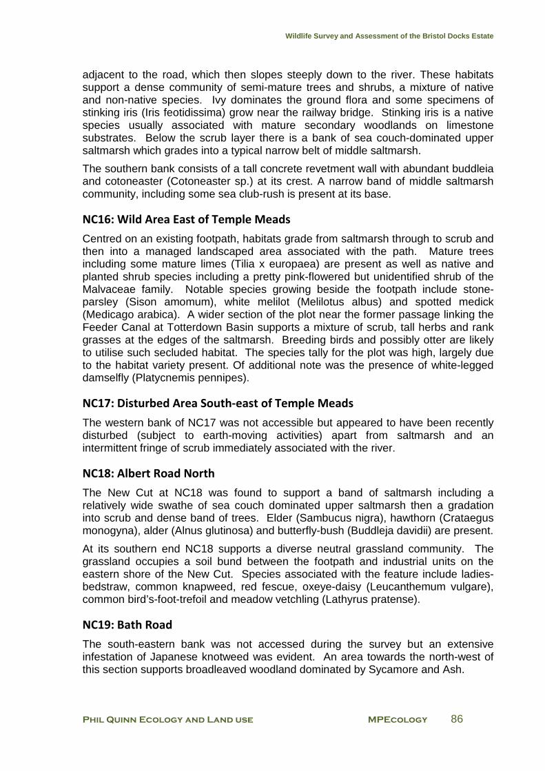
Wildlife Survey and Assessment of the Bristol Docks Estate
Phil Quinn Ecology and Land use MPEcology 86
adjacent to the road, which then slopes steeply down to the river. These habitats support a dense community of semi-mature trees and shrubs, a mixture of native and non-native species. Ivy dominates the ground flora and some specimens of stinking iris (Iris feotidissima) grow near the railway bridge. Stinking iris is a native species usually associated with mature secondary woodlands on limestone substrates. Below the scrub layer there is a bank of sea couch-dominated upper saltmarsh which grades into a typical narrow belt of middle saltmarsh.
The southern bank consists of a tall concrete revetment wall with abundant buddleia and cotoneaster (Cotoneaster sp.) at its crest. A narrow band of middle saltmarsh community, including some sea club-rush is present at its base.
NC16: Wild Area East of Temple Meads
Centred on an existing footpath, habitats grade from saltmarsh through to scrub and then into a managed landscaped area associated with the path. Mature trees including some mature limes (Tilia x europaea) are present as well as native and planted shrub species including a pretty pink-flowered but unidentified shrub of the Malvaceae family. Notable species growing beside the footpath include stone-parsley (Sison amomum), white melilot (Melilotus albus) and spotted medick (Medicago arabica). A wider section of the plot near the former passage linking the Feeder Canal at Totterdown Basin supports a mixture of scrub, tall herbs and rank grasses at the edges of the saltmarsh. Breeding birds and possibly otter are likely to utilise such secluded habitat. The species tally for the plot was high, largely due to the habitat variety present. Of additional note was the presence of white-legged damselfly (Platycnemis pennipes).
NC17: Disturbed Area South-east of Temple Meads
The western bank of NC17 was not accessible but appeared to have been recently disturbed (subject to earth-moving activities) apart from saltmarsh and an intermittent fringe of scrub immediately associated with the river.
NC18: Albert Road North
The New Cut at NC18 was found to support a band of saltmarsh including a relatively wide swathe of sea couch dominated upper saltmarsh then a gradation into scrub and dense band of trees. Elder (Sambucus nigra), hawthorn (Crataegus monogyna), alder (Alnus glutinosa) and butterfly-bush (Buddleja davidii) are present.
At its southern end NC18 supports a diverse neutral grassland community. The grassland occupies a soil bund between the footpath and industrial units on the eastern shore of the New Cut. Species associated with the feature include ladies-bedstraw, common knapweed, red fescue, oxeye-daisy (Leucanthemum vulgare), common bird’s-foot-trefoil and meadow vetchling (Lathyrus pratense).
NC19: Bath Road
The south-eastern bank was not accessed during the survey but an extensive infestation of Japanese knotweed was evident. An area towards the north-west of this section supports broadleaved woodland dominated by Sycamore and Ash.

Wildlife Survey and Assessment of the Bristol Docks Estate
Phil Quinn Ecology and Land use MPEcology 87
NC20: Albert Road South
NC20 forms a continuation of NC18 and is relatively diverse in character. A small infestation of Japanese knotweed was recorded here.
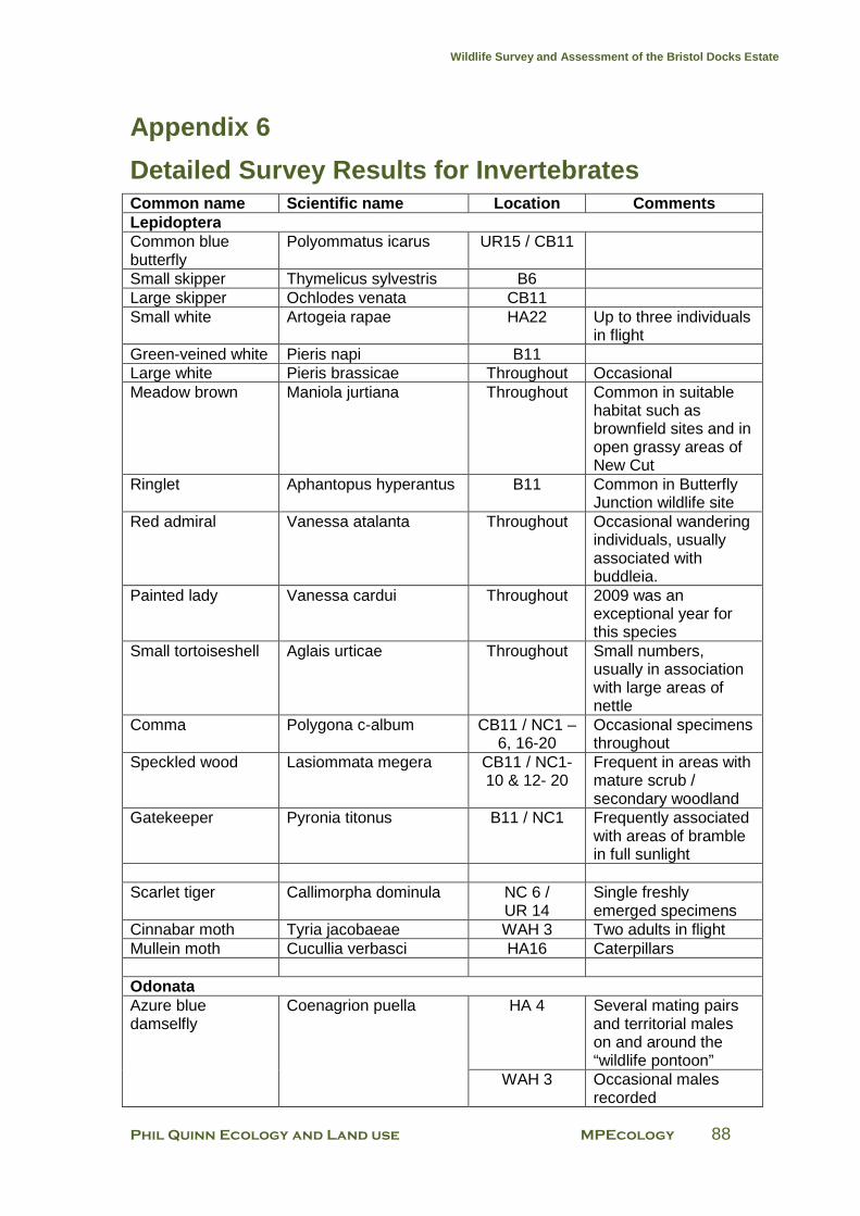
Wildlife Survey and Assessment of the Bristol Docks Estate
Phil Quinn Ecology and Land use MPEcology 88
Appendix 6
Detailed Survey Results for Invertebrates Common name Scientific name Location Comments Lepidoptera Common blue butterfly
Polyommatus icarus UR15 / CB11
Small skipper Thymelicus sylvestris B6 Large skipper Ochlodes venata CB11 Small white Artogeia rapae HA22 Up to three individuals
in flight Green-veined white Pieris napi B11 Large white Pieris brassicae Throughout Occasional Meadow brown Maniola jurtiana Throughout Common in suitable
habitat such as brownfield sites and in open grassy areas of New Cut
Ringlet Aphantopus hyperantus B11 Common in Butterfly Junction wildlife site
Red admiral Vanessa atalanta Throughout Occasional wandering individuals, usually associated with buddleia.
Painted lady Vanessa cardui Throughout 2009 was an exceptional year for this species
Small tortoiseshell Aglais urticae Throughout Small numbers, usually in association with large areas of nettle
Comma Polygona c-album CB11 / NC1 – 6, 16-20
Occasional specimens throughout
Speckled wood Lasiommata megera CB11 / NC1-10 & 12- 20
Frequent in areas with mature scrub / secondary woodland
Gatekeeper Pyronia titonus B11 / NC1 Frequently associated with areas of bramble in full sunlight
Scarlet tiger Callimorpha dominula NC 6 /
UR 14 Single freshly emerged specimens
Cinnabar moth Tyria jacobaeae WAH 3 Two adults in flight Mullein moth Cucullia verbasci HA16 Caterpillars Odonata Azure blue damselfly
Coenagrion puella HA 4 Several mating pairs and territorial males on and around the “wildlife pontoon”
WAH 3 Occasional males recorded
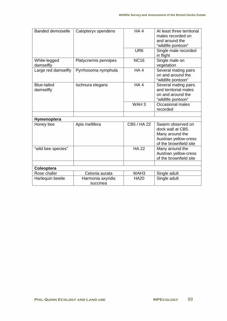
Wildlife Survey and Assessment of the Bristol Docks Estate
Phil Quinn Ecology and Land use MPEcology 89
Banded demoiselle Calopteryx spendens HA 4 At least three territorial males recorded on and around the “wildlife pontoon”
UR6 Single male recorded in flight
White-legged damselfly
Platycnemis pennipes NC16 Single male on vegetation
Large red damselfly Pyrrhosoma nymphula HA 4 Several mating pairs on and around the “wildlife pontoon”
Blue-tailed damselfly
Ischnura elegans HA 4 Several mating pairs and territorial males on and around the “wildlife pontoon”
WAH 3 Occasional males recorded
Hymenoptera Honey bee Apis mellifera CB5 / HA 22 Swarm observed on
dock wall at CB5. Many around the Austrian yellow-cress of the brownfield site
“wild bee species” HA 22 Many around the Austrian yellow-cress of the brownfield site
Coleoptera Rose chafer Cetonia aurata WAH3 Single adult Harlequin beetle Harmonia axyridis
succinea HA20 Single adult
Wildlife Survey and Assessment of the Bristol Docks Estate
Phil Quinn Ecology and Land use MPEcology 90
Appendix 7
Detailed Survey Results for Birds Common name Scientific name Location Comments Cormorant Phalacrocorax carbo WAH 1 Mute swan Cygnus olor HA 2 Six eggs in nest 15th
June (a pair breed here regularly -2 out of 6 eggs laid in 2008 hatched)
NC 6 Abandoned nest by Gaol Ferry Bridge
UR 1- 4 Small numbers around Bristol Bridge
Canada goose Branta canadensis HA 21 Pair flew in to rest on open water
Mallard Anas platyrhynchos WAH 9 Female with brood of nine young
WAH 5 -6 Singles and pairs frequent
HA 20 Female with recently hatched brood of five young
Moorhen
Gallinula chlorops HA 2 Heard from within dense vegetation; nesting suspected
UR 3 One bird recorded UR 16 -17 At least three territorial
pairs; one partially fledged chick recorded in UR 17
Lesser black-backed gull
Larus fuscus Throughout Particular concentrations of small loafing / bathing flocks in broad area of open water at southern end of HA 7
Herring gull Larus argentatus Throughout Less frequent than lesser black-backed
Woodpigeon Columba palumbus HA 22 Calling from tall tree Feral pigeon Throughout Particular
concentration of breeding activity along UR1
House martin WAH 5, 7-9 Many active nests; many adults buzzing around over the western end of the Water Activity Harbour
Sand martin Riparia riparia UR 17 Colony of at least four pairs in drainage holes in concrete bank
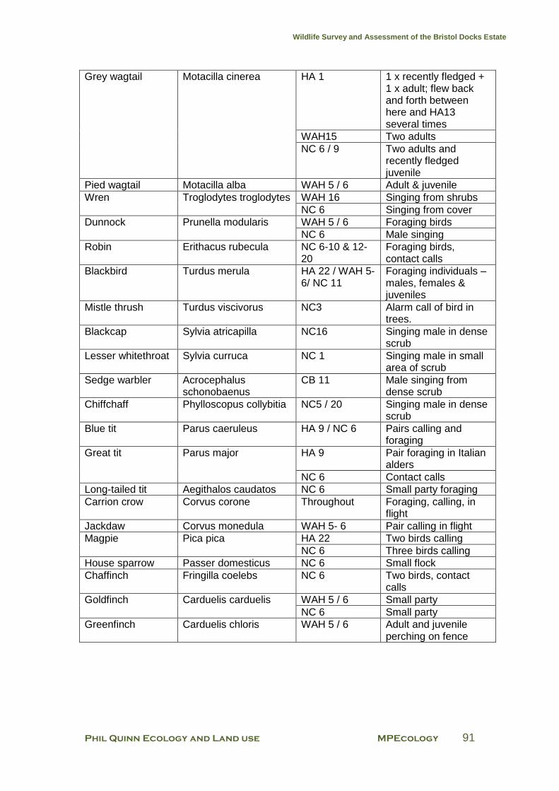
Wildlife Survey and Assessment of the Bristol Docks Estate
Phil Quinn Ecology and Land use MPEcology 91
Grey wagtail Motacilla cinerea HA 1 1 x recently fledged + 1 x adult; flew back and forth between here and HA13 several times
WAH15 Two adults NC 6 / 9 Two adults and
recently fledged juvenile
Pied wagtail Motacilla alba WAH 5 / 6 Adult & juvenile Wren Troglodytes troglodytes WAH 16 Singing from shrubs
NC 6 Singing from cover Dunnock Prunella modularis WAH 5 / 6 Foraging birds
NC 6 Male singing Robin Erithacus rubecula NC 6-10 & 12-
20 Foraging birds, contact calls
Blackbird Turdus merula HA 22 / WAH 5-6/ NC 11
Foraging individuals –males, females & juveniles
Mistle thrush Turdus viscivorus NC3 Alarm call of bird in trees.
Blackcap Sylvia atricapilla NC16 Singing male in dense scrub
Lesser whitethroat Sylvia curruca NC 1 Singing male in small area of scrub
Sedge warbler Acrocephalus schonobaenus
CB 11 Male singing from dense scrub
Chiffchaff Phylloscopus collybitia NC5 / 20 Singing male in dense scrub
Blue tit Parus caeruleus HA 9 / NC 6 Pairs calling and foraging
Great tit Parus major HA 9 Pair foraging in Italian alders
NC 6 Contact calls Long-tailed tit Aegithalos caudatos NC 6 Small party foraging Carrion crow Corvus corone Throughout Foraging, calling, in
flight Jackdaw Corvus monedula WAH 5- 6 Pair calling in flight Magpie Pica pica HA 22 Two birds calling
NC 6 Three birds calling House sparrow Passer domesticus NC 6 Small flock Chaffinch Fringilla coelebs NC 6 Two birds, contact
calls Goldfinch Carduelis carduelis WAH 5 / 6 Small party
NC 6 Small party Greenfinch Carduelis chloris WAH 5 / 6 Adult and juvenile
perching on fence
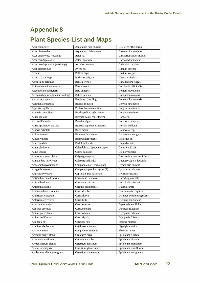
Wildlife Survey and Assessment of the Bristol Docks Estate
Phil Quinn Ecology and Land use MPEcology 92
Appendix 8
Plant Species List and Maps Acer campestre Asplenium ruta-muraria Ceterarch officinarum
Acer platanoides Asplenium trichomanes Chaenorhinum minus
Acer platanoides (seedling) Aster sp. Chamerion angustifolium
Acer pseudoplatanus Aster tripolium Chenopodium album
Acer pseudoplatanus (seedlings) Atriplex prostrata Cichorium intybus
Acer saccharinum Avena sp. Cirsium arvense
Acer sp. Ballota nigra Cirsium vulgare
Acer sp.(seedling) Barbarea vulgaris Clematis vitalba
Achillea millefolium Bellis perennis Clinopodium vulgare
Adiantum capillus-veneris Berula erecta Cochlearia officinalis
Aegopodium podagraria Beta vulgaris Conium maculatum
Aesculus hippocastaneum (sapling) Betula pendula Conopodium majus
Aethusa cynapium Betula sp. (seedling) Convolvulus arvensis
Agrimonia eupatoria Bidens frondosa Conyza canadensis
Agrostis capillaris Bolboschoenus maritimus Conyza sumatrensis
Agrostis stolonifera Brachypodium sylvaticum Cornus sanguinea
Ajuga reptans Brassica napus ssp. oleifera Cornus sp.
Alchemilla molle Brassica nigra Coronopus didymus
Alisma plantago-aquatica Brassica rapa ssp. campestris Corylus avellana
Alliaria petiolata Briza media Cotoneaster sp.
Allium roseum Bromus cf.carinatus Crataegus monogyna
Allium vineale Bromus hordeaceus Crataegus sp.
Alnus cordata Buddleja davidii Crepis biennis
Alnus glutinosa Calendula sp. (garden escape) Crepis capillaris
Alnus incana Caltha palustris Crepis vesicaria
Alopecurus geniculatus Calystegia sepium Crocosmia x crocosmiiflora
Amaranthus retroflexus Calystegia silvatica Cupressocyparis leylandii
Anacamptis pyramidalis Campanula portenschlagiana Cymbalaria muralis
Anagallis arvensis Campanula poscharskyana (T) Cynosurus cristatus
Angelica sylvestris Capsella bursa-pastoralis Cytisus scoparius
Anisantha cf.madritensis Cardamine flexuosa Dactylis glomerata
Anisantha diandra Cardamine hirsuta Dactylorhiza fuchsii
Anisantha sterilis Carduus acanthoides Daucus carota
Anthoxanthum odoratum Carex divulsa Deschampsia cespitosa
Anthriscus caucaulis Carex flacca Dianthus deltoides (garden)
Anthriscus sylvestris Carex hirta Digitaria sanguinalis
Antirrhinum majus Carex otrubae Diplotaxis tenuifolia
Aphanes arvensis Carex pendula Dipsacus fullonum
Apium graveolens Carex remota Dryopteris dilatata
Apium nodiflorum Carex riparia Dryopteris filix-mas
Aquilegia sp. Carex spicata Elymus caninus
Arabidopsis thaliana Catabrosa aquatica Elytrigia atherica
Arctium minus Catapodium rigidum Elytrigia repens
Arenaria serpyllifolia Centaurea nigra Epilobium ciliatum
Armoracia rusticana Centranthus ruber Epilobium hirsutum
Arrhenatherum elatius Cerastium fontanum Epilobium montanum
Artemisia vulgaris Cerastium glomeratum Epilobium parviflorum
Asplenium adiantum-nigrum Cerastium tomentosum Epilobium tetragonum

Wildlife Survey and Assessment of the Bristol Docks Estate
Phil Quinn Ecology and Land use MPEcology 93
Equisetum arvense Ilex aquifolium Melilotus alba
Erigeron acer Impatiens glandulifera Melilotus altissimus
Erigeron karvinskianus Iris foetidissima Melilotus officinalis
Erodium cicutarium Iris pseudacorus Melilotus sp.
Erophila verna Iris sp. Mentha aquatica
Erysimum cheiri Jasminum sp. Mercurialis annua
Eupatorium cannabinum Juncus bufonius Mimulus sp.
Euphorbia helioscopa Juncus inflexus Mycelis muralis
Euphorbia peplus Juncus tenuis Myosotis arvensis
Fallopia baldschuanica Knautia arvensis Nigella damascena
Fallopia convolvulus Kniphofia sp. Nuphar lutea
Fallopia japonica Lactuca serriola Odontites verna
Festuca arundinacea Lactuca virosa Oenanthe crocata
Festuca rubra Lamiastrum galeobdolon (garden) Oenothera biennis
Festuca sp. (ornamental) Lamium album Oenothera glazioviana
Ficus carica Lamium amplexicaule Orobanche hederae
Filipendula ulmaria Lamium purpureum Orobanche minor
Foeniculum vulgare Lapsana communis Oxalis articulata
Fragaria vesca var. Lathyrus latifolius Oxalis corniculata
Fraxinus excelsior Lathyrus odoratus Papaver dubium dubium
Fraxinus excelsior f. diversifolia Lathyrus pratensis Papaver dubium lecoqii
Fumaria officinalis Lavandula sp. Papaver rhoeas
Galinsoga quadriradiata Lemna minor Papaver somniferum
Galium aparine Leontodon autumnalis Parietaria judaica
Galium mollugo Leontodon saxatilis Parthenocissus quinquefolia
Galium verum Lepidium draba Pentaglottis sempervirens
Geranium dissectum Lepidium ruderale Persicaria maculosa
Geranium lucidum Leucanthemum vulgare Phalaris arundinacea
Geranium molle Leucanthemum x superbum Phalaris canariensis
Geranium pratense Leycesteria formosa Phleum pratense
Geranium pyrenaicum Ligustrum ovalifolium Phragmites australis
Geranium robertianum Linaria purpurea Phyllitis scolopendrium
Geranium rotundifolium Linaria vulgaris Picris echioides
Geum urbanum Lobelia sp. Pilosella offinarum
Gladiolus sp. Lolium multiflorum Pinus sp.
Glechoma hederacea Lolium perenne Plantago coronopus
Glyceria fluitans Lonicera nitida (orn shrub) Plantago lanceolata
Hedera helix Lonicera periclymenum Plantago major
Heracleum mantegazzianum Lonicera sp. (shrrub) Plantago maritima
Heracleum sphondylium Lotus corniculatus Platanus x hispanica
Hesperis matronalis Lunaria annua Poa angustifolia
Hieracium sp. Luzula campestris Poa annua
Hirschfeldia incana Lycopus europaeus Poa compressa
Holcus lanatus Lysimachia punctata Poa pratensis
Hordeum murinum Malus domestica Poa trivialis
Humulus lupulus Malva moschata Polygonum arenastrum
Hyacinthoides sp. (cf.hispanica) Malva sylvestris Polygonum aviculare
Hypericum androsaemum Malvaceae Polypodium interjectum
Hypericum perforatum Matricaria discoidea Polypogon monspeliensis
Hypericum sp. Meconopsis cambrica Polypogon viridis
Hypericum sp. (shrub) Medicago arabica Populus sp.
Hypericum tetrapterum Medicago lupulina Potentilla reptans
Hypochoeris radicata Medicago sativa ssp. sativa Potentilla sterilis
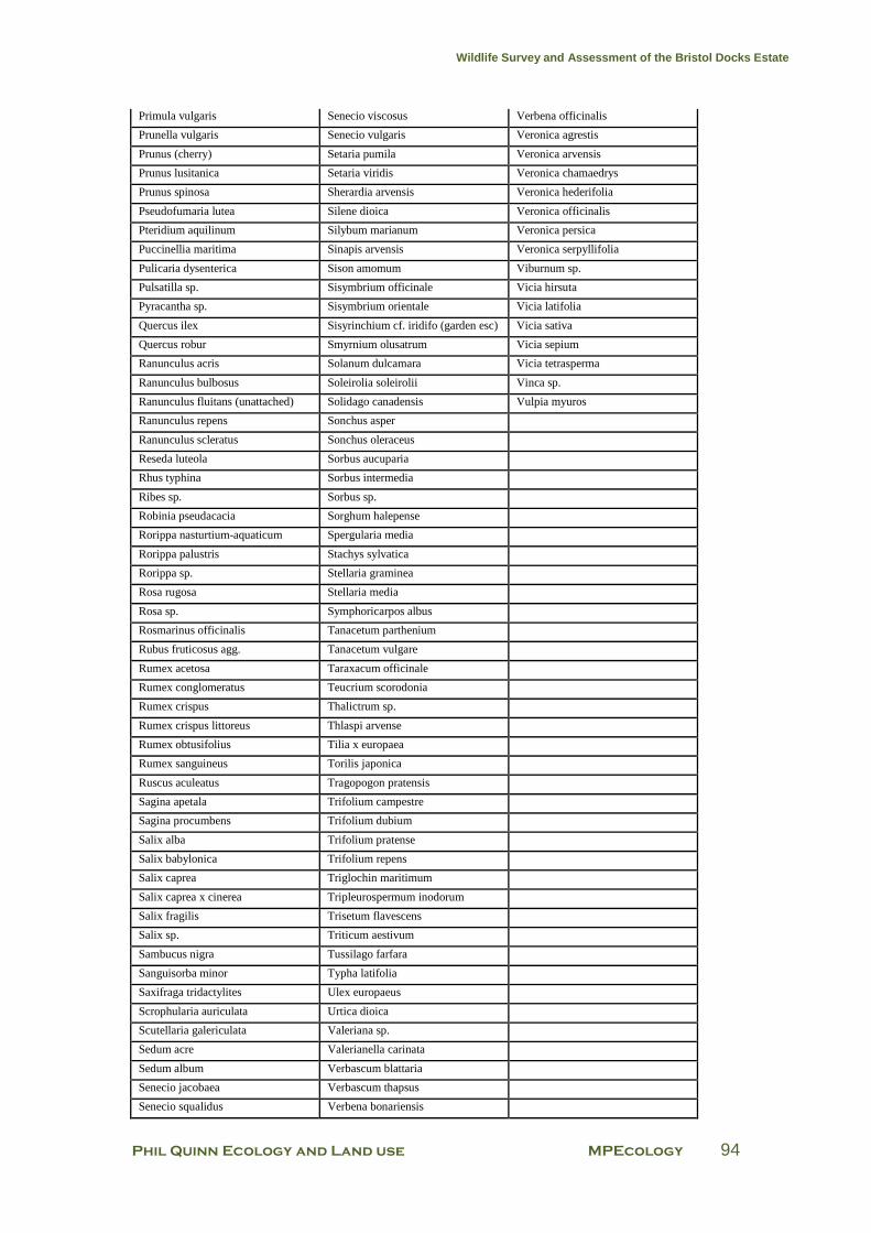
Wildlife Survey and Assessment of the Bristol Docks Estate
Phil Quinn Ecology and Land use MPEcology 94
Primula vulgaris Senecio viscosus Verbena officinalis
Prunella vulgaris Senecio vulgaris Veronica agrestis
Prunus (cherry) Setaria pumila Veronica arvensis
Prunus lusitanica Setaria viridis Veronica chamaedrys
Prunus spinosa Sherardia arvensis Veronica hederifolia
Pseudofumaria lutea Silene dioica Veronica officinalis
Pteridium aquilinum Silybum marianum Veronica persica
Puccinellia maritima Sinapis arvensis Veronica serpyllifolia
Pulicaria dysenterica Sison amomum Viburnum sp.
Pulsatilla sp. Sisymbrium officinale Vicia hirsuta
Pyracantha sp. Sisymbrium orientale Vicia latifolia
Quercus ilex Sisyrinchium cf. iridifo (garden esc) Vicia sativa
Quercus robur Smyrnium olusatrum Vicia sepium
Ranunculus acris Solanum dulcamara Vicia tetrasperma
Ranunculus bulbosus Soleirolia soleirolii Vinca sp.
Ranunculus fluitans (unattached) Solidago canadensis Vulpia myuros
Ranunculus repens Sonchus asper
Ranunculus scleratus Sonchus oleraceus
Reseda luteola Sorbus aucuparia
Rhus typhina Sorbus intermedia
Ribes sp. Sorbus sp.
Robinia pseudacacia Sorghum halepense
Rorippa nasturtium-aquaticum Spergularia media
Rorippa palustris Stachys sylvatica
Rorippa sp. Stellaria graminea
Rosa rugosa Stellaria media
Rosa sp. Symphoricarpos albus
Rosmarinus officinalis Tanacetum parthenium
Rubus fruticosus agg. Tanacetum vulgare
Rumex acetosa Taraxacum officinale
Rumex conglomeratus Teucrium scorodonia
Rumex crispus Thalictrum sp.
Rumex crispus littoreus Thlaspi arvense
Rumex obtusifolius Tilia x europaea
Rumex sanguineus Torilis japonica
Ruscus aculeatus Tragopogon pratensis
Sagina apetala Trifolium campestre
Sagina procumbens Trifolium dubium
Salix alba Trifolium pratense
Salix babylonica Trifolium repens
Salix caprea Triglochin maritimum
Salix caprea x cinerea Tripleurospermum inodorum
Salix fragilis Trisetum flavescens
Salix sp. Triticum aestivum
Sambucus nigra Tussilago farfara
Sanguisorba minor Typha latifolia
Saxifraga tridactylites Ulex europaeus
Scrophularia auriculata Urtica dioica
Scutellaria galericulata Valeriana sp.
Sedum acre Valerianella carinata
Sedum album Verbascum blattaria
Senecio jacobaea Verbascum thapsus
Senecio squalidus Verbena bonariensis
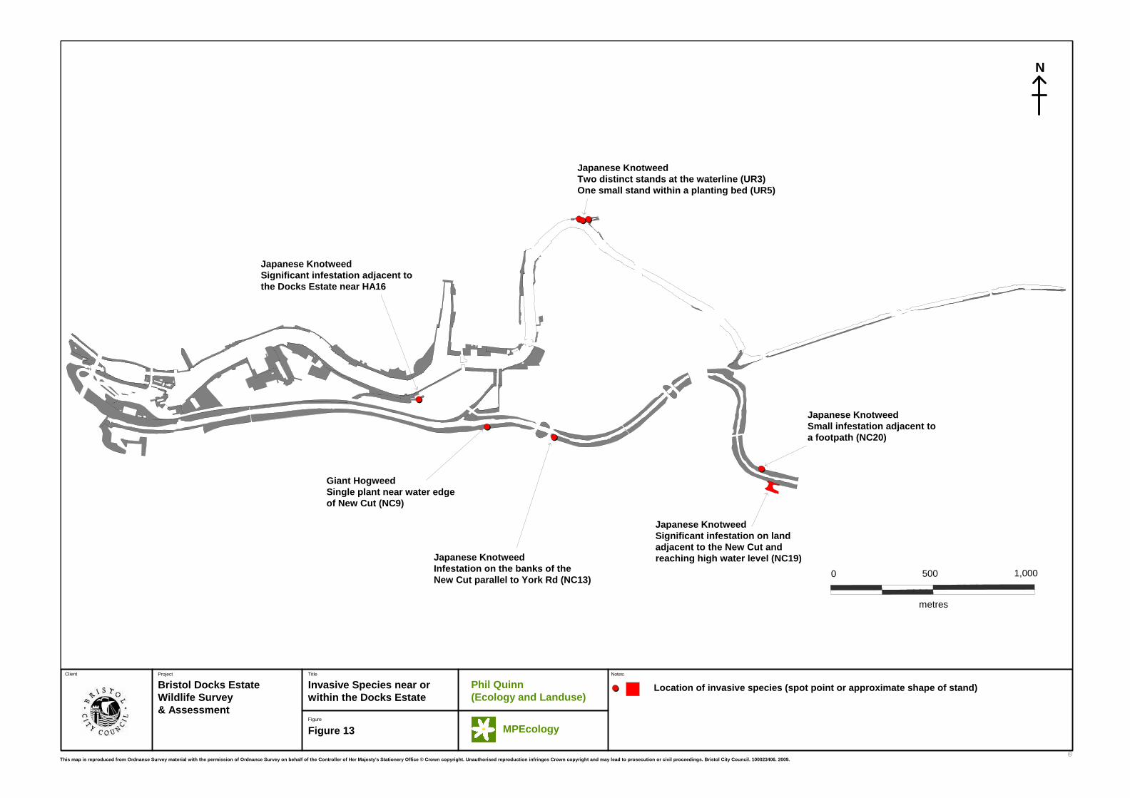
C
Project Title
Bristol Docks EstateWildlife Survey & Assessment
Invasive Species near or within the Docks Estate
C
Figure
Client
Figure 13
Notes:
1,000500
metres
0
N
Phil Quinn (Ecology and Landuse)
MPEcology
This map is reproduced from Ordnance Survey materia l with the permission of Ordnance Survey on behalf of the Controller of Her Majesty's Stationery Offic e © Crown copyright. Unauthorised reproduction infr inges Crown copyright and may lead to prosecution o r civil proceedings. Bristol City Council. 10002340 6. 2009.
Location of invasive species (spot point or approxi mate shape of stand)
Japanese KnotweedTwo distinct stands at the waterline (UR3)One small stand within a planting bed (UR5)
Japanese KnotweedSignificant infestation adjacent tothe Docks Estate near HA16
Giant HogweedSingle plant near water edgeof New Cut (NC9)
Japanese KnotweedInfestation on the banks of the New Cut parallel to York Rd (NC13)
Japanese KnotweedSignificant infestation on landadjacent to the New Cut andreaching high water level (NC19)
Japanese KnotweedSmall infestation adjacent toa footpath (NC20)

C
Project Title
Bristol Docks EstateWildlife Survey & Assessment
Notable Species DistributionWater-bent / Beggarticks
C
Figure
Client
Figure 14
Notes:
1,000500
metres
0
N
Phil Quinn (Ecology and Landuse)
MPEcology
This map is reproduced from Ordnance Survey materia l with the permission of Ordnance Survey on behalf of the Controller of Her Majesty's Stationery Offic e © Crown copyright. Unauthorised reproduction infr inges Crown copyright and may lead to prosecution o r civil proceedings. Bristol City Council. 10002340 6. 2009.
Water-bent (Polypogon viridis)
Beggarticks (Bidens frondosa)
Dots indicate presence within survey plot rather th an exact location or number of plants.
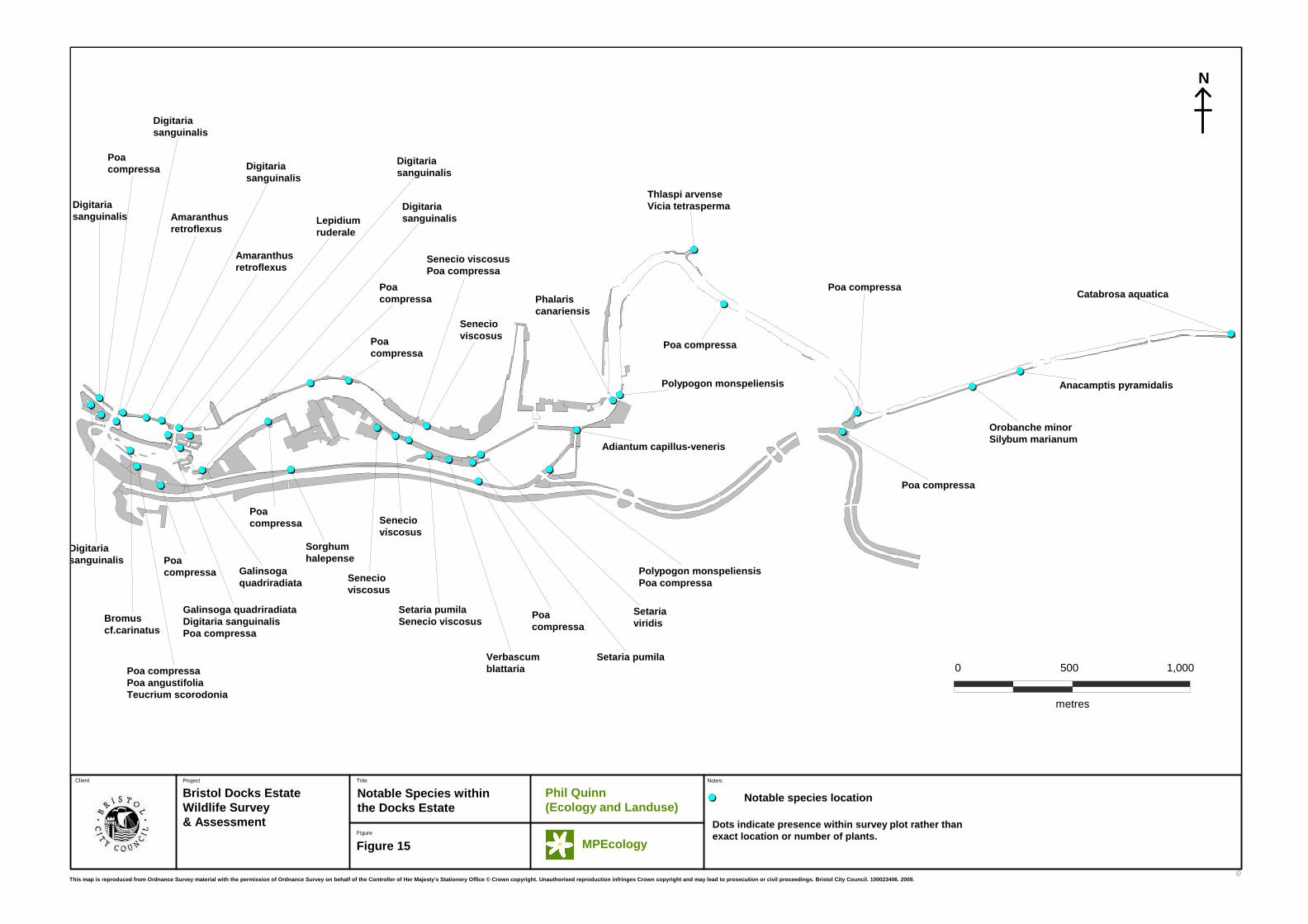
C
Project Title
Bristol Docks EstateWildlife Survey & Assessment
Notable Species withinthe Docks Estate
C
Figure
Client
Figure 15
Notes:
1,000500
metres
0
Catabrosa aquatica
Anacamptis pyramidalis
Orobanche minorSilybum marianum
Senecio viscosus
Senecio viscosus
Sorghum halepense
Setaria pumilaSenecio viscosus
Digitaria sanguinalis
Digitaria sanguinalis
Senecio viscosusPoa compressa
Lepidium ruderale
Verbascum blattaria
Setaria pumila
Poa compressa
Senecio viscosus
Poa compressa
Galinsoga quadriradiata
Galinsoga quadriradiataDigitaria sanguinalisPoa compressa
Setaria viridis
Polypogon monspeliensisPoa compressa
Adiantum capillus-veneris
Poa compressaPoa angustifoliaTeucrium scorodonia
Digitaria sanguinalis
Amaranthus retroflexus
Amaranthus retroflexus
Poa compressa
Bromus cf.carinatus
Digitaria sanguinalis
Poa compressa
Digitaria sanguinalis
Digitaria sanguinalis
Poa compressa
Poa compressa Phalaris
canariensis
Polypogon monspeliensis
Poa compressa
Poa compressa
Poa compressa
Thlaspi arvenseVicia tetrasperma
N
Phil Quinn (Ecology and Landuse)
MPEcology
This map is reproduced from Ordnance Survey materia l with the permission of Ordnance Survey on behalf of the Controller of Her Majesty's Stationery Offic e © Crown copyright. Unauthorised reproduction infr inges Crown copyright and may lead to prosecution o r civil proceedings. Bristol City Council. 10002340 6. 2009.
Notable species location
Dots indicate presence within survey plot rather th an exact location or number of plants.
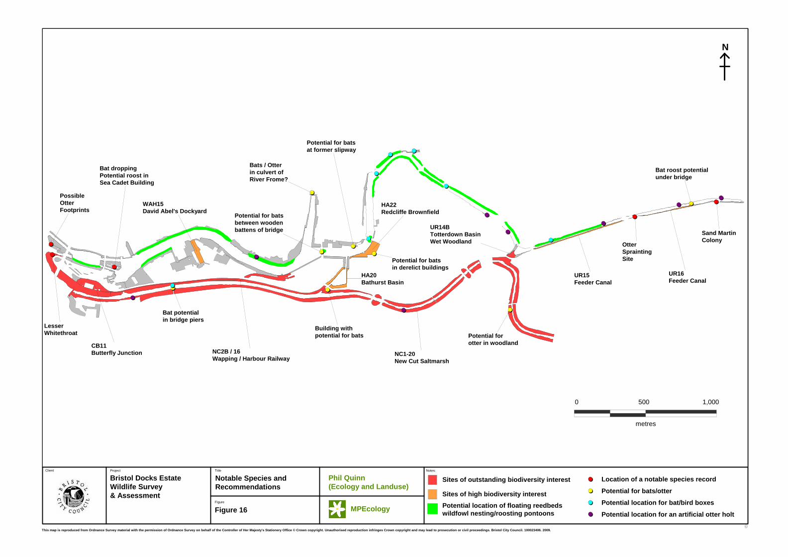
C
Project Title
Bristol Docks EstateWildlife Survey & Assessment
Notable Species andRecommendations
C
Figure
Client
Figure 16
Notes:
1,000500
metres
0
Potential for bats in derelict buildings
UR14BTotterdown BasinWet Woodland
HA20Bathurst Basin
HA22Redcliffe Brownfield
Potential for bats at former slipway
Building with potential for bats
WAH15David Abel's Dockyard
Bat dropping Potential roost in Sea Cadet Building
Potential for bats between wooden battens of bridge
Otter Sprainting Site
UR15Feeder Canal
Bat roost potential under bridge
Sand Martin Colony
UR16Feeder Canal
NC1-20New Cut Saltmarsh
NC2B / 16Wapping / Harbour Railway
Lesser Whitethroat
CB11Butterfly Junction
Possible Otter Footprints
Potential for otter in woodland
Bat potential in bridge piers
Bats / Otter in culvert of River Frome?
N
Phil Quinn (Ecology and Landuse)
MPEcology
This map is reproduced from Ordnance Survey materia l with the permission of Ordnance Survey on behalf of the Controller of Her Majesty's Stationery Offic e © Crown copyright. Unauthorised reproduction infr inges Crown copyright and may lead to prosecution o r civil proceedings. Bristol City Council. 10002340 6. 2009.
Location of a notable species record
Potential for bats/otter
Potential location for bat/bird boxes
Potential location for an artificial otter holtPotential location of floating reedbedswildfowl nesting/roosting pontoons
Sites of outstanding biodiversity interest
Sites of high biodiversity interest