Embed Size (px)
Citation preview

1
Wing Village: A Walk Through History
This document is intended to assist a guided walk through some of the headlines of
Wing’s history. It isn’t intended to stand alone as a comprehensive account. For a more
detailed expression of Wing’s history see ‘A History of Wing Village and Its Setting
1066 – 2018’, David Seviour, 2018, together with its companion power-point
presentation entitled ‘Historical Setting: Wing Village a Timeline’. For a more detailed
description of Wing’s Historic England Listed Buildings see ‘A Directory of Wing’s
Listed Buildings’, David Seviour, 2018.
First find the starting point - the Wing Maze on the Glaston Road. It is enclosed by a
white post and rail fence immediately adjacent to the village recreation field, close to the
Village Hall which is next door to the Church of St. Peter & St. Paul, built in 1150. See
Map on last page. The walk will take you approximately one hour if you read the notes.
Walk past the Maze for about one
hundred & twenty paces and you will
top the hill. To the south the Glaston
Road leads to a brook which cuts the
road in the bottom of the valley.
Behind you to the north is the Chater
valley with its river. These two water
courses define the southern and
northern boundaries of Wing Parish.
The Parish was once part of the
Dower Lands held in 1066 by Queen Edith, the wife of Edward ‘The Confessor’. They
were appropriated by William ‘The Conqueror’ by 1086 as noted in the Domesday
record and given as dower lands to his niece, the Countess Judith. The Wessex Saxon
dynasties came to an end, law, language and life in England changed dramatically.
On the top of this hill, looking south, you will see Mill Close on your left – modern
houses. You are at point (1) on the map.
The year is 1209. Imagine two medieval post-mills, one on your left, on the corner of
Mill Close, the other on your right in the small field enclosure once called Mill Field,
where chickens currently peck the grass. William, the Prior of St. Neots controls half
Wing Manor and Ralph, Abbot of Thorny controls the other half, both at the behest of
Thurston de Montfort. (For more detail look up Wing Mysteries Part 4 on the Wing
Village website)
Close your eyes. The mill on the left has been turned by the miller into a position to
catch the wind from the north-east. This mill was built on the highest ground for such

2
purpose, but the prevailing wind today is coming from the south-west and so the mill
built on your right for this optimum wind catch has its sails turning and you can hear
the mill-stones grinding. The miller is standing beside the mill talking to a man with a
horse and cart which is already loaded with three sacks of course light brown flour.
The year is now 1264 and if you turn
around there are no trees on the green
field of the hill-top plateau, so you can
see the Church and between you and the
small church building, in the open field,
there are two groups of people, one of
pilgrims and one of traders, camped for
the night. The traders, a group of about
a dozen people, travelling together for
safety, have two armed men with them
and are due to head south along the
Glaston Road for Northampton
tomorrow. They have travelled from Lincoln and have just watered their horses from
the spring by the church.
The other group comprises a nun, two monks, two lay-brother servants with stout staffs
and one armed retainer, who are all on foot and eating in the open air before spending
the night in the church. Tomorrow they travel north towards Lincoln Cathedral and
then York Cathedral in the days thereafter. The monks at each of these cathedrals will
give them a night’s lodgings.
Beyond the traders’ tents, across the Wing plateau field located at its cross-roads,
beyond the stone church, there is a small cluster of clay and thatched cottages. In every
direction beyond that you can only see Royal Forest, dangerous forest because of thieves
and wolves that roam looking for prey.
Times are troubled; King John is dead, his son, King Henry III has been defeated and
captured by his brother-in-law, Simon de Montfort, 6th Earl of Leicester, Lord of the
surrounding lands, and de facto ruler of England. His supporters are a group of barons
who wish to see the restoration of the rights King John conceded at Oxford in what
became known as Magna Carta.
Open your eyes and retrace your steps to point (2) on the map, the Maze circle.
The Maze is cut into the turf and has the same pattern as the pavement labyrinth at
Chartres Cathedral and as that of a maze cut into the hillside at Alkborough,
Lincolnshire, close by the Humber ferry crossing on the York Road which the Romans
called Ermine Street. Simon de Montfort the fifth Earl of Leicester had close ties with
Chartres and both he and his son were religious zealots, the former having led the
Albigensian Crusade. (For more details look up Wing Mysteries Part 6 on the Wing
Village website).
3
There is speculation as to the meaning of such mazes and the shapes and origins vary.
This maze is likely to be medieval and probably ‘badges’ or ‘brands’ the route for
pilgrims at the Wing major cross-roads where the London/Northampton/Lincoln/York
main road crossed the Leicester/Stamford main road.
These ‘badges’ also probably marked the jurisdiction of a friend of the 6th Earl, the
Bishop of Lincoln Robert Grosseteste and his Church Court, who regulated most
aspects of life. Locally the maze also signified that the two wind-mills were on land
gifted by the de Montfort family to the Abbot of Thorny and Prior of St. Neots in
Huntingdon.
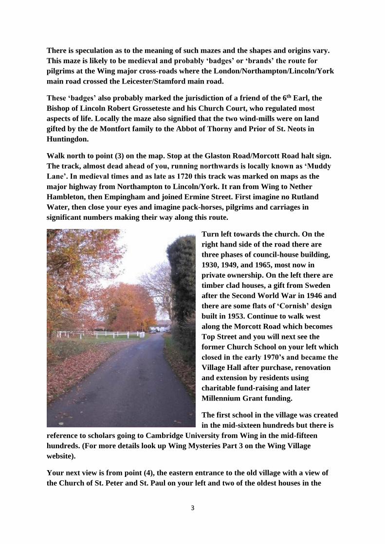
Walk north to point (3) on the map. Stop at the Glaston Road/Morcott Road halt sign.
The track, almost dead ahead of you, running northwards is locally known as ‘Muddy
Lane’. In medieval times and as late as 1720 this track was marked on maps as the
major highway from Northampton to Lincoln/York. It ran from Wing to Nether
Hambleton, then Empingham and joined Ermine Street. First imagine no Rutland
Water, then close your eyes and imagine pack-horses, pilgrims and carriages in
significant numbers making their way along this route.
Turn left towards the church. On the
right hand side of the road there are
three phases of council-house building,
1930, 1949, and 1965, most now in
private ownership. On the left there are
timber clad houses, a gift from Sweden
after the Second World War in 1946 and
there are some flats of ‘Cornish’ design
built in 1953. Continue to walk west
along the Morcott Road which becomes
Top Street and you will next see the
former Church School on your left which
closed in the early 1970’s and became the
Village Hall after purchase, renovation
and extension by residents using
charitable fund-raising and later
Millennium Grant funding.
The first school in the village was created
in the mid-sixteen hundreds but there is
reference to scholars going to Cambridge University from Wing in the mid-fifteen
hundreds. (For more details look up Wing Mysteries Part 3 on the Wing Village
website).
Your next view is from point (4), the eastern entrance to the old village with a view of
the Church of St. Peter and St. Paul on your left and two of the oldest houses in the

4
village on your right – ‘Corner House’ circa 1650’s and ‘Townsend House’ 1622. The
drawing of the church below is the only known view of its spire. The very early
photograph pre-dates the rebuilding of the chancel and the extension of the vestry and
organ chamber, so before 1875. The spire was taken down in 1841 having become
unsafe because of alterations to take more bells. The foreground shows the old village
‘pound’ or ‘pinfold’ created from hurdles to hold stray animals.
The other photograph showing the old eastern approach to the ‘town’ is from the early
1930’s. Corner House (below left) was originally called Corbel House and Townsend
House (below right) was originally called Corner Farmhouse because it occupied the
corner plot before Corbel House was built.
The original rectory, next to the church was built in
the early 1600’s, occupied by the Rev. Professor
Francis Meres, vicar 1602-1647. His son, Francis,
became Headmaster of Uppingham School and
Archdeacon of Leicester. The Rectory, now called
Churchfield, was part demolished in the 1840’s and
is now very much smaller than shown on the
photograph (left) which must have been taken before
1840.
Stand on the corner of Top Street, Morcott Road, and Church Street, point (5) on the
map. The main buildings at this intersection were built in the reigns of King James I
and his son King Charles I. By this time the Manor of Wing had been repossessed by
Henry VIII and gifted to Princess Elizabeth (as dowry?). As Queen Elizabeth I she let
the land out and its keeper, Sir Everard Digby, was later executed after involvement in

5
the Gunpowder Plot. The lands then found their way into the possession of Thomas
Cecil, son of Elizabeth’s closest advisor Lord Burghley, and half-brother to Robert
Cecil, who negotiated James VI of Scotland’s accession to the English throne as King
James I. Both brothers were rewarded by King James, Thomas as Earl of Exeter and
Robert as Earl of Salisbury. The Manor of Wing then passed to Thomas’ son and
remained in the Lordship of the Marquess of Exeter until the present day.
The historical setting for these houses is the troubled years of the English Civil Wars.
Close your eyes. Charles I frequently stays at his palace at Apethorpe, an eight mile ride
from Wing. Oliver Cromwell, Lieutenant General in the Eastern Association
parliamentary army, Governor of Ely, and having lived at both Huntingdon and St.
Neots before Ely, is making speed to engage the Royalist Army in Leicestershire. His
representative in Rutland lives in Nether Hambleton. The armies clash on the 13th June
1645 two miles from the village of Naseby, a twenty-five mile ride from Wing. Cromwell
is victorious. After evasion, a second civil war and capture, Charles is executed in 1649.
Cromwell refuses the crown and is made Lord Protector in 1657, dying in 1658.
The Restoration of the monarchy takes place with Charles II in 1660 but fundamental
changes in science, religion, education, and the notion of Parliamentary Democracy over
the ‘Divine Right of Kings’ changes England forever.
Wing Church and the three houses mentioned are Grade II Listed by Historic England.
(For more information on the Church of St. Peter and St. Paul look up Wing Mysteries
Part 2 on the Wing Village website).
Turn right and walk downhill along Church Street. Spring water often surfaces and
trickles down the road close to number
3 Church Street, probably rising from
the same spring that rose close to the
church. A map of 1886 shows seventeen
wells and hand-pumps located across
the village. Clean spring water was
probably the reason for ‘Wenge’,
derived from the Old Norse word
‘vengi’ or ‘field’, being cleared on top
of the hill within the forest in the first
place, and together with the main track
routes east/west and north/south crossing at Wing, also gave rise to the siting of the
church haven and hence Wing hamlet. Wenge was once in Danelaw, the five boroughs;
York, Derby, Leicester, Northampton, and Stamford. After number 3 Church Street
stop at point (6) on the map. On your left is Wing House, Grade II Listed and built with
its barn in the mid - 18th century but carrying a quoin stone dated 1673, so probably the
site of an earlier house.

6
The wall and gates on the opposite side of the road enclosing Wing House tennis court
are of later 19th century date but are also Listed and provide an open view down into
the Chater River valley.
Also, on the right hand side of Church Street at this point there are three other Grade II
Listed properties; 6 Church Street, the Barns at 6 Church Street, both early 19th
century, and Inglewood Cottage, the white cottage which is earlier, late 17th century, so
a chronological follow on to Corner House and Townsend House and a contemporary
structure to the Wing House predecessor building.
Resume walking. Turning the left hand
curve of Church Street towards Bottom
Street, both of which are referred to as
‘Far Street’ on the map of 1886, there is
‘The Haven’, a 19th century property on
the right having a complete documented
history which was made available by its
former owner, such documentation
revealing a story of Copyhold
transactions in the Manor Court prior to
and after the Victorian legislation that led to enfranchisement of copyholders. These
papers demonstrate that medieval land tenure didn’t come to an end in Wing until the
20th century!
Pause for a moment. Close your eyes and imagine less than two hundred years ago all
land within the Parish, except around two hundred acres, was concentrated in two
ownerships; over five hundred acres belonging to the Sheild family and over seven
hundred acres belonging to the Marquess of Exeter. 52% of all land in Rutland
belonged to four landowners, the second largest share being held by the Marquess of
Exeter. In Wing there were only seven other individuals who held land of more than an
acre and not all of these were resident in Wing.
The 1841 census for Wing demonstrates an overwhelming involvement of its population
in agriculture, higher than the Rutland 43%, and very high compared to the national
figure of 21%. For the 2011 census this figure for Wing had dropped to 2%.
Wing Parish Records for births, marriages and deaths for the 1600’s, and the 1800’s,
taken in conjunction with the 1841 and 2011 census data for family names, demonstrate
that whilst some family names endured most did not. It seems likely that the nature of
land tenure had a lot to do with this. The 1841 census recorded ten ‘Heads of household’
as ‘farmers’ by occupational status but this was not synonymous with freehold
ownership. Most will have rented their farms. By the 1950’s Parish Records
demonstrate that farm horses had disappeared, and mechanized methods had taken
over. Industrialization may have attracted labour to the local towns and cities, away
from the land, but labour was also pushed off the land in the 1700’s by enclosure

7
through large landowners’ efficiency drives, and in the late 1900’s through
mechanization by large landowners with the same efficiency objectives.
Open your eyes. Still on the right, 20 Church Street, known now as Sundial House, was
three cottages used as alms-houses and dates to the early 17th century, contemporary
with Townsend House and the Civil War. They are also Grade II Listed.
See drawing and photograph below. This period marks religiously driven emigration to
the Americas and Parish Records of the mid 1600s make mention of ‘Quakers’ and
‘Anabaptists’.
The next street on you left is Middle Street, point (7) on the map. Immediately on the
right looking up Middle Street numbers 17 and 15 are Grade II Listed and date to the
mid-18th century. After that there is ‘The Old Post Office’ dating to the same period
and then number 7, Grade II Listed, dating to 1771.
Between number 15 and The Old Post
Office there is a gateway which once led to the farm buildings at the back of the manor-
house, that is Cedar House (see below). Out of sight down this gravel drive are located a
large stone dovecote dated 1756 and a stone laundry dated to a slightly later period,
both now part of Dove Cottage and its studio. (See next four photographs below).
Middle Street marks the end of the Stuarts and Wing’s Georgian or Hanoverian period,
spanning George I, George II and George III, together with the loss of the American
colonies. This period also marks the height of the Sheild family with their family initials
appearing on many buildings erected over this century. Wing churchyard once had a
8
significant sarcophagi plot for the family surrounded by iron railings. The family
burial plot is now a sad affair, completely untended.
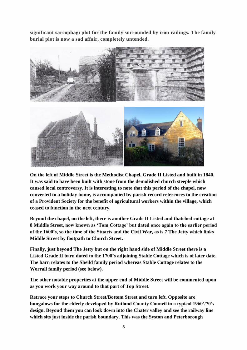
On the left of Middle Street is the Methodist Chapel, Grade II Listed and built in 1840.
It was said to have been built with stone from the demolished church steeple which
caused local controversy. It is interesting to note that this period of the chapel, now
converted to a holiday home, is accompanied by parish record references to the creation
of a Provident Society for the benefit of agricultural workers within the village, which
ceased to function in the next century.
Beyond the chapel, on the left, there is another Grade II Listed and thatched cottage at
8 Middle Street, now known as ‘Tom Cottage’ but dated once again to the earlier period
of the 1600’s, so the time of the Stuarts and the Civil War, as is 7 The Jetty which links
Middle Street by footpath to Church Street.
Finally, just beyond The Jetty but on the right hand side of Middle Street there is a
Listed Grade II barn dated to the 1700’s adjoining Stable Cottage which is of later date.
The barn relates to the Sheild family period whereas Stable Cottage relates to the
Worrall family period (see below).
The other notable properties at the upper end of Middle Street will be commented upon
as you work your way around to that part of Top Street.
Retrace your steps to Church Street/Bottom Street and turn left. Opposite are
bungalows for the elderly developed by Rutland County Council in a typical 1960’/70’s
design. Beyond them you can look down into the Chater valley and see the railway line
which sits just inside the parish boundary. This was the Syston and Peterborough

9
branch of the Midland Railway built in 1848. You can also see the site of Manton
Station at Wing Hollow in the distance and which became a very busy mainline station
with shunting yards by 1880. Two of the original three lines feeding this railway
junction are still in use but the shunting yards have gone, the station was closed in 1966
and rail traffic numbers are much smaller and quieter.
Close your eyes. The year is 1874 and Victoria is queen. The trains on the Midland
Railway line through the Chater Valley are busy, tooting and puffing smoke. Cromwell
Farmhouse in Wing Hollow (now a Grade II Listed house) is a busy pub with a
reputation for rowdy gangs of railway construction workers getting drunk. Far more
horse drawn carriages are using the lanes to take their wealthy owners to Manton
Station to catch trains to London. Itinerant railway navvies are camped along the
cuttings of two other main-line routes being built to link the Rugby, Market
Harborough and Stamford line with the London and North Western railway at
Luffenham, and the Great Northern Railway Company is constructing a line via the
Harringworth viaduct and seeking to link it to the Midland at Manton Junction. The
Wing Parish Council are writing letters of objection to the Board of Trade about the
likely further disruption of the local roads which leads to Glaston and Wing tunnel
construction. Suddenly the area is filled with temporary workers blasting their way
through the rock, and local quarries are expanding their activities because stone is
needed for the construction of all the tunnels, bridges and banking, and the trains are
providing more commercial opportunities for exporting their stone to other areas. The
late Georgian farming idyll is struggling with the demands of a more aggressive
commercial and industrial age. The grime and grit of Victorian cities has arrived on
Wing’s doorstep.
Open your eyes and continue along Bottom Street to point (8) on the map. On your left
is Cedar House, a Grade II Listed manor house dated to the 1700’s but with a late
Victorian frontage. This was the home of the Sheild family who owned most of the
village until they began wholesale disposal of land and properties in the late 1800’s.
They are something of an enigma since they were strong if not dominant gentry in
Preston, Uppingham and Wing for over two hundred years and then virtually
disappeared. There are clues to their demise, (see Wing Mysteries Part 1 on the Wing
Village website) but no-one seems to have unravelled the full story.

10
The Barn at the rear of Cedar House is also Grade II Listed and this court-yard with its
stables was once accessed off Middle Street past the dovecote and laundry serving the
main house. It also had orchards with walkways that connected the manor-house to
workers cottages at the junction of Middle Street and Top Street.
Walking on, there is a left turn into Reeves Lane and as you make that turn on the
north side of the corner an old road,
now a footpath, ran off diagonally
north-west to join the Manton Road.
Just by it there used to be the
‘Westhorpe water hand-pump’ where
cattle were watered, and it was said that
this spring never ran dry even when
other pumps in the village failed.
Westhorpe Farmhouse and barn are
just around the corner in Reeves Lane
on the left. They were built in the 17th
century, are Grade II Listed but were
extensively rebuilt in the mid-19th
century. On the right, the second house
up from the corner, nearly opposite
Westhorpe is Westcott,
possibly the oldest house in the village, 1539 – 1694 but much altered, as many of the
early houses were in the 19th
century.
The rest of Reeves Lane is an
eclectic mixture of architecture
and periods. Walk to the top of
Reeves Lane and stop at the
junction with Top Street, just
beyond the track running off to
the right. Point (9) on the map.
First looking back along Top
Street you can see the front stone
wall and line of magnificent trees
at the entrance and frontage to
Old Wing Hall. The Old Hall was
built by George Wyatt Worrall in
the 1880’s on land acquired from
the Sheild family. The back of the
house incorporated cottages built in 1773 and is accessed off the top of Middle Street. It
is Grade II Listed. George Wyatt Worrall was one of eight children who inherited a
11
huge family fortune derived from innovative industrial processes in Salford related to
dying cloth. One of his brothers, Edward Worrall, built New Wing Hall in the 1890’s.
Between them they acquired much of the Sheild land and property holdings and built a
number of other houses along Top Street.
The descendants of the Worralls also built further properties in the village and Dorothy
Worrall gifted the recreational field to the village. Her daughter, Elizabeth, the last
Worrall, married and became Elizabeth Tulloch, her son Richard now living at
Glenbervie Farm and her daughter, Robina, living at New Wing Hall.
Over on the right are the village allotments which once were the village stone and gravel
pits. The stone was used for the roads and this land was awarded to the village under
the terms of an Enclosure Act in 1772.
Continue to walk out of the village along Wing Hill in a south-westerly direction. Wing
Grange and Cromwell Farmhouse are within the Parish boundaries along the Preston
and Manton Roads respectively from the former gibbet crossroads at the bottom of
Wing Hill, but they are beyond the village boundaries and the scope of this walk.
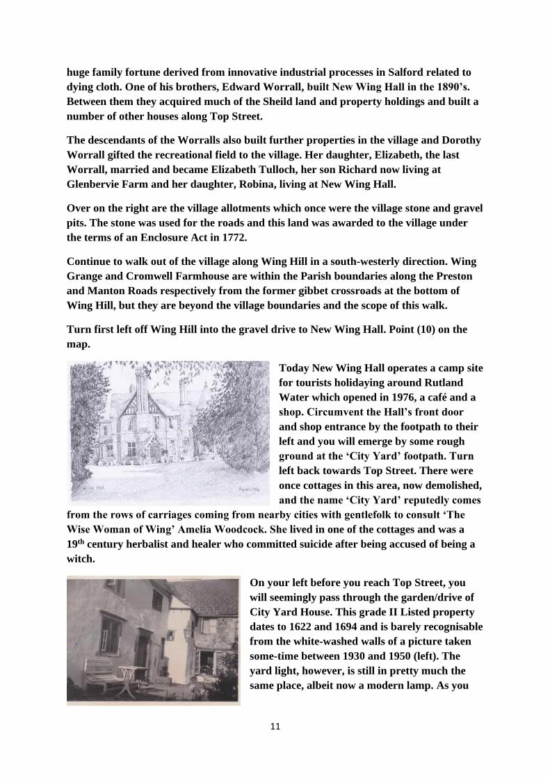
Turn first left off Wing Hill into the gravel drive to New Wing Hall. Point (10) on the
map.
Today New Wing Hall operates a camp site
for tourists holidaying around Rutland
Water which opened in 1976, a café and a
shop. Circumvent the Hall’s front door
and shop entrance by the footpath to their
left and you will emerge by some rough
ground at the ‘City Yard’ footpath. Turn
left back towards Top Street. There were
once cottages in this area, now demolished,
and the name ‘City Yard’ reputedly comes
from the rows of carriages coming from nearby cities with gentlefolk to consult ‘The
Wise Woman of Wing’ Amelia Woodcock. She lived in one of the cottages and was a
19th century herbalist and healer who committed suicide after being accused of being a
witch.
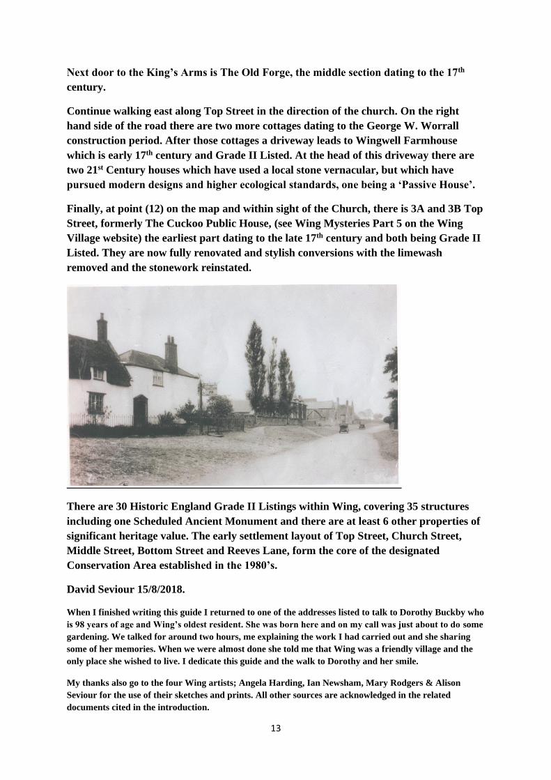
On your left before you reach Top Street, you
will seemingly pass through the garden/drive of
City Yard House. This grade II Listed property
dates to 1622 and 1694 and is barely recognisable
from the white-washed walls of a picture taken
some-time between 1930 and 1950 (left). The
yard light, however, is still in pretty much the
same place, albeit now a modern lamp. As you

12
emerge into Top Street the house opposite was the butlers’ house for Old Wing Hall in
the time of the Worralls.
Turn right into Top Street and immediately on your right is the Kings Arms pub in
Kings Arms Yard. Point (11) on the map. It is Grade II Listed, the oldest section in the
middle dating to 1694.
Looking up this yard from
the road, the last building on
the left used to be the village
bakery and was still in
operation in the 1930’s. There
are old photographs that
show former mill-stones being
used as threshold flagstones
for both the bakery and the
pub’s front entrance. The pub
landlord of the 1930’s and the
Wing miller of 1884 –1881
were related. The village
bakery building was
subsequently used as an art studio before it was absorbed into the pub’s operations.
Today there are four professional artists living in the village and there are three studios
located in their gardens. All have produced work for this guide.
Opposite the King’s Arms you can see part of Old Wing Hall (above right), but only the
rear areas that abut Middle Street. Beyond Old Wing Hall in Middle Street is Wing
Lodge which principally dates to the Worrall period of reconstructing the Hall.
On the right hand corner of Middle Street/Top Street is Garden Cottage which together
with its barn and water pump are all separately Grade II Listed. The oldest part of the
house dates to 1688. Next door to Garden Cottage on Top Street there are two cottages
constructed by Edward Worrall.
13
Next door to the King’s Arms is The Old Forge, the middle section dating to the 17th
century.
Continue walking east along Top Street in the direction of the church. On the right
hand side of the road there are two more cottages dating to the George W. Worrall
construction period. After those cottages a driveway leads to Wingwell Farmhouse
which is early 17th century and Grade II Listed. At the head of this driveway there are
two 21st Century houses which have used a local stone vernacular, but which have
pursued modern designs and higher ecological standards, one being a ‘Passive House’.
Finally, at point (12) on the map and within sight of the Church, there is 3A and 3B Top
Street, formerly The Cuckoo Public House, (see Wing Mysteries Part 5 on the Wing
Village website) the earliest part dating to the late 17th century and both being Grade II
Listed. They are now fully renovated and stylish conversions with the limewash
removed and the stonework reinstated.
There are 30 Historic England Grade II Listings within Wing, covering 35 structures
including one Scheduled Ancient Monument and there are at least 6 other properties of
significant heritage value. The early settlement layout of Top Street, Church Street,
Middle Street, Bottom Street and Reeves Lane, form the core of the designated
Conservation Area established in the 1980’s.
David Seviour 15/8/2018.
When I finished writing this guide I returned to one of the addresses listed to talk to Dorothy Buckby who
is 98 years of age and Wing’s oldest resident. She was born here and on my call was just about to do some
gardening. We talked for around two hours, me explaining the work I had carried out and she sharing
some of her memories. When we were almost done she told me that Wing was a friendly village and the
only place she wished to live. I dedicate this guide and the walk to Dorothy and her smile.
My thanks also go to the four Wing artists; Angela Harding, Ian Newsham, Mary Rodgers & Alison
Seviour for the use of their sketches and prints. All other sources are acknowledged in the related
documents cited in the introduction.

14
Copyright is asserted in relation to this original text and its constituent sources. It may be downloaded by
village visitors and walkers for free. For commercial reproduction contact [email protected]
![walk4life.info · Web viewLYONSHALL MEDIEVAL WALKS Walk No. 1. [Lyonshall Village Hall - circuitous route taking approximately one hour]. Start point: The Village “Memorial” Hall](https://img.pdfslide.net/doc/110x75/5e6525335a9331133070ecd5/web-view-lyonshall-medieval-walks-walk-no-1-lyonshall-village-hall-circuitous.jpg)