Embed Size (px)
Citation preview

Don Carroll Non-Executive Chairman
Nathan Taylor
Non-Executive Director
Eddie King Non-Executive Director
David Palumbo
Company Secretary
1 December 2016
WMN Acquires Prospective Gold Portfolio
(Amended)
WMN acquires 3 gold prospective projects, including 4
tenements: Defiance (E38/3062), Mt Howe (E39/1878 and 1879)
and the Unknown (P27/2005).
Defiance, and Mt Howe lie within the Laverton Tectonic Zone, one
of the best endowed gold regions in Australia with over 28 million
ounces of gold produced.
385,000oz in gold resources lie on strike and within 1.5km of the
Defiance Project
The Mt Howe Project lies adjacent to the Safari Shear Zone (Pinjin
Fault); the same structure that hosts Granny Smith and Red
October mines to the north.
Multiple significant drill intersections across the projects
including:
o Defiance
15m @ 3.08g/t Au from 136m Including 1m @
23.57g/t Au (EMRC001)
11m @ 2.89g/t Au from 67m(RFAC030)
Including 4m@ 4.34g/t Au & 1m @ 8.17g/t Au
3m @ 2.28g/t Au from 68m & 1m @ 6.13g/t Au from
102m(RFRC002)
o Mt Howe
2m @ 2.29g/t Au from 41m(TDRC024)
1m @ 5.07g/t Au from 84m(TDRC035)
5m @ 1.79g/t Au from 26m (TDRC036)
8m @ 1.27g/t Au from 34m (TDRC026)
o Unknown
Historical production of 611oz Au between 1905 and
1908
Western Mining Network Limited (ASX: WMN, “the Company”) is
pleased to announce that it has acquired a prospective gold
portfolio in the Eastern Goldfields Province of Western Australia. The
Company has secured four Licences:
E38/3062, or “Defiance”, lies 10km’s immediately southwest of
Laverton, in one of the best endowed gold regions in Australia
with over 28 million ounces of gold produced in recent history
(the Laverton Tectonic Zone that includes Granny Smith,
Sunrise Dam and Wallaby gold deposits);
For
per
sona
l use
onl
y

E39/1878 and 1879, or “Mt Howe”, lies on the southern extensions of
the aforementioned Laverton Tectonic Zone, immediately adjacent to
the structure that hosts the Granny Smith, Red October and Safari Bore
gold deposits; and,
The Unknown historic gold working located on P27/2005, just north of
Bulong.
PROJECT SUMMARIES: LAVERTON TECTONIC ZONE
Defiance
The project covers parts of the Chatterbox Shear, including the Rumour line
of mineralisation, one of three gold deposits (Innuendo, Whisper and Rumour)
originally discovered by Metex Resources Limited in 1997. The northern parts
of the Rumour line now include the Emerald Gold Deposit (2.65mt @ 2.1g/t for
179,000oz). Whereas along strike and slightly further north, the Whisper line
includes the Apollo
gold deposit (2.73mt
@ 2.3g/t Au for
206,000oz).
The mineralisation of
the Chatterbox Shear
occurs over 5.5 km’s,
within a package of
metacarbonates,
sediments and felsic
intrusives, overlying an
ultramafic horizon. The
hanging wall is
predominantly
tholeiites and banded
iron formation (BIF).
The Rumour line is
known to extend into
the Defiance
tenement by several
hundred metres.
The oxide
mineralisation
generally comprises
NNE- to N-trending,
moderately to steeply
E-dipping and
shallowly S-plunging,
anastomosing lenses.
Figure 1: Defiance Gold Project
For
per
sona
l use
onl
y

Table 1: Defiance Project Drill Results
Hole From Interval Au g/t Comments
EMRC001
86 2 1.64
99 4 1.75
136 15 3.08
Including 1m @ 23.57g/t Au
EMRC003 60 6 0.95
175 2 1.61
RFAC030
67 11 2.89
Including 1m @ 8.17g/t Au
85 8 0.81
RFAC031
45 1 1.22
56 1 1.45 Mineralised at
EOH
RFAC046 43 1 1.51
RFAC050 96 2 1.27
RFAC097 62 1 1.84
RFAC100 39 1 5.47
RFRC001
53 1 1.21
62 2 1.72
81 6 0.84
RFRC002 68 3 2.28
102 1 6.13
RFRC005 60 2 2.03
78 2 2.32
RFRC006
32 1 1.81
72 1 5.90
93 1 2.48
RFRC006 111 1 5.01
RFRC008 92 2 1.87
96 1 3.26
RFRC009 104 5 1.26
RFRC010 100 4 1.12
129 1 5.31
RFRC011 67 2 1.94
The mineralisation is set within goethite-hematite-Mn oxide± quartz
(carbonate) veining, brecciation texture.
The intensely altered and deformed lithologies within the shear are extremely
weathered, with depths to unoxidized material exceeding 150m.
For
per
sona
l use
onl
y

Figure 2: Defiance Project: >1g/t Drilling Intercepts (Pink Star), <1g/t Drill holes (blue circle)
The project is located on the east limb of the regional southeast-plunging
Margaret Anticline. The Chatterbox Shear Zone is a complex north-striking,
east-dipping ductile-brittle fault zone that can be traced over a length of
30km.
The project is mantled by Quaternary and Permian cover of variable
thickness, immediately west of the prominent ridges developed in BIF. The
Permian sediments are glacial to fluvioglacial deposits of the Paterson
Formation, and consist predominantly of fine-grained claystones, and
For
per
sona
l use
onl
y

siltstones with a few grits. Ferruginous duricrusts, 2-5m thick, are preserved
over greenstone, granite, and the Patterson Formation within the tenure.
Reported drilling results are tabled and presented below.
Mt Howe Project
Figure 3: Mt Howe Project Collar Plan
The Mt Howe Project lies within the S extension of the Laverton Tectonic Zone,
approximately 160km northeast of Kalgoorlie. The project lies between the
Mount Celia (host to the Mount Morgans gold deposit) and Pinjin Faults (also
referred to as the Safari Shear Zone, which hosts Granny Smith, Red October,
and the Safari Bore gold deposits). The 0.5 Moz Safari deposit lies 14km’s
southeast of Mt Howe.
The bedrock geology consists of an assemblage of highly sheared and
silicified/carbonatised quartz-sericite-chlorite schists (altered rhyolites and
rhyodacties) with intercalated carbonaceous shales, along with minor BIF,
chert, chloritic schist and in places weakly sheared intermediate and felsic
metavolcanic rocks. Variable amounts of quartz veining and generally trace
disseminated pyrite were recorded in most holes. Depths of weathering along
the mineralised zone varies between 15-80m.
The metamorphic grade is mostly greenschist, with amphibolite facies
localised marginal to any granitic intrusive (porphyritic syenite, adamellite,
and granodiorite).
The area is completely blanketed by transported overburden which ranges
between 1-40m thick.
For
per
sona
l use
onl
y

This target is an interpreted structure that is part of the anatomising set of
shears hosting the Butcher Well, Safari Bore and Kangaroo Bore deposits. The
main target is coincident with NE cross faulting and a contact between
sediment with BIF beds and felsic volcanic. Much of this structural trend is
under thin recent cover and has been subjected to little effective systematic
exploration.
Rotary air blast (RAB) and RC drilling has been completed across the Project.
Significant RC drill hole data has been compiled and is listed below. A total of
65 RC drill holes for 7,001m have been completed. The results from the drilling
indicate a mineralised target corridor of 950x400m that warrants further
investigation.
Table 2: Mt Howe Project Drilling Results
Hole From Interval Au g/t Report
TDRC021 36 1 1.03 A48714
TDRC022 No Significant Results A48714
TDRC023 68 1 0.72 A48714
TDRC024
41 2 2.29 A48714
45 1 2.23 A48714
53 2 1.13 A48714
97 6 0.95 A48714
TDRC025 86 1 0.59 A48714
TDRC026 34 8 1.27 A48714
47 4 0.60 A48714
TDRC033 No Significant Results A48714
TDRC034 74 2 0.92 A48714
TDRC035 48 1 1.5 A48714
84 1 5.07 A48714
TDRC036 8 2 0.7 A48714
TDRC036
20 4 1.95 A48714
Including 1m @ 4.36g/t Au A48714
26 5 1.79 A48714
Including 1m @ 3.22g/t Au A48714
TDRC046 No Significant Results A48714
TDRC047 74 5 1.85 A48714
Including 1m @ 6.38g/t Au A48714
TDRC052 No Significant Results A48714
TDRC052 No Significant Results A48714
TDRC053 No Significant Results A48714
TDRC054 31 3 0.92 A48714
TDRC055 No Significant Results A48714
TDRC056 No Significant Results A48714
TDRC057 41 1 0.98 A48714
For
per
sona
l use
onl
y
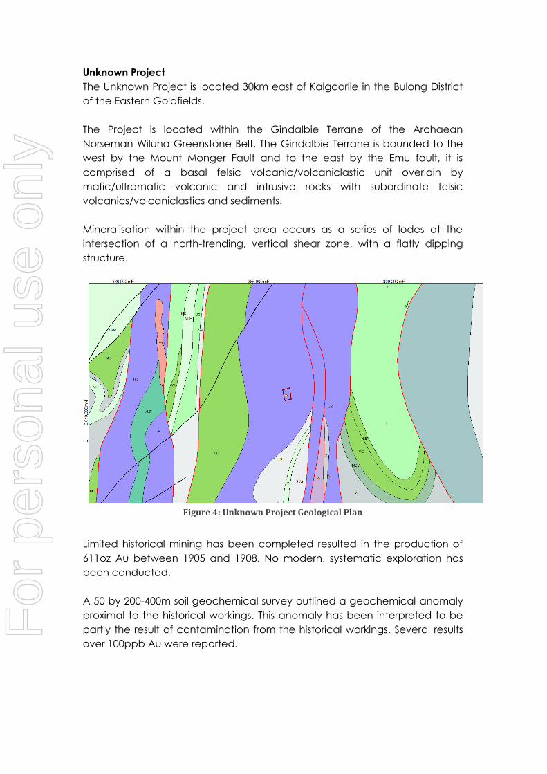
Unknown Project
The Unknown Project is located 30km east of Kalgoorlie in the Bulong District
of the Eastern Goldfields.
The Project is located within the Gindalbie Terrane of the Archaean
Norseman Wiluna Greenstone Belt. The Gindalbie Terrane is bounded to the
west by the Mount Monger Fault and to the east by the Emu fault, it is
comprised of a basal felsic volcanic/volcaniclastic unit overlain by
mafic/ultramafic volcanic and intrusive rocks with subordinate felsic
volcanics/volcaniclastics and sediments.
Mineralisation within the project area occurs as a series of lodes at the
intersection of a north-trending, vertical shear zone, with a flatly dipping
structure.
Figure 4: Unknown Project Geological Plan
Limited historical mining has been completed resulted in the production of
611oz Au between 1905 and 1908. No modern, systematic exploration has
been conducted.
A 50 by 200-400m soil geochemical survey outlined a geochemical anomaly
proximal to the historical workings. This anomaly has been interpreted to be
partly the result of contamination from the historical workings. Several results
over 100ppb Au were reported.
For
per
sona
l use
onl
y

COMMERCIAL TERMS
The Company has acquired 100% of the Licences for a total of $60,000 cash
based consideration to the Vendors comprising of:
a) $3,000 to Redfield Pty Ltd for P27/2005
b) $19,000 to a Prospector for E38/3062
c) $19,000 to a Prospector for E38/1878
d) $19,000 to a Prospector for E38/1879
Upon the delineation of an Inferred Mineral Resource in accordance with the
JORC 2012 Edition Guidelines of 100,000oz at a minimum grade of 1g/t Au
across the Licences, Western Mining will issue $100,000 of Fully Paid Ordinary
Shares as consideration.
Upon the delineation of an Inferred Mineral Resource in accordance with the
JORC 2012 Edition Guidelines of 200,000oz at a minimum grade of 1g/t Au
across the Licences, Western Mining will issue $200,000 of Fully Paid Ordinary
Shares as consideration.
The Vendors are to retain a first right of refusal on the disposal of the
Licence(s).
DISCLAIMER
Forward-looking statements are statements that are not historical facts. Words such
as “expect(s)”, “feel(s)”, “believe(s)”, “will”, “may”, “anticipate(s)” and similar
expressions are intended to identify forward-looking statements. These statements
include, but are not limited to statements regarding future production, resources or
reserves and exploration results. All of such statements are subject to certain risks and
uncertainties, many of which are difficult to predict and generally beyond the
control of the Company, that could cause actual results to differ materially from
those expressed in, or implied or projected by, the forward-looking information and
statements. These risks and uncertainties include, but are not limited to: (i) those
relating to the interpretation of drill results, the geology, grade and continuity of
mineral deposits and conclusions of economic evaluations, (ii) risks relating to
possible variations in reserves, grade, planned mining dilution and ore loss, or
recovery rates and changes in project parameters as plans continue to be refined,
(iii) the potential for delays in exploration or development activities or the completion
of feasibility studies, (iv) risks related to commodity price and foreign exchange rate
fluctuations, (v) risks related to failure to obtain adequate financing on a timely basis
and on acceptable terms or delays in obtaining governmental approvals or in the
completion of development or construction activities, and (vi) other risks and
uncertainties related to the Company’s prospects, properties and business strategy.
Our audience is cautioned not to place undue reliance on these forward-looking
statements that speak only as of the date hereof, and we do not undertake any
obligation to revise and disseminate forward-looking statements to reflect events or
circumstances after the date hereof, or to reflect the occurrence of or non-
occurrence of any events.
For
per
sona
l use
onl
y

COMPETENT PERSONS STATEMENT:
The information in this announcement that relates to the historical Exploration Results is based
on information compiled and fairly represented by Mr Jonathan King, who is a Member of the
Australian Institute of Geoscientists and a consultant to Western Mining Network Ltd. Mr King
has sufficient experience relevant to the style of mineralisation and type of deposit under
consideration, and to the activity which he has undertaken, to qualify as a Competent Person
as defined in the 2012 Edition of the Joint Ore Reserves Committee (JORC) Australasian Code
for Reporting of Exploration Results, Mineral Resources and Ore Reserves. Mr King consents to
the inclusion in this report of the matters based on this information in the form and context in
which it appears.
For
per
sona
l use
onl
y

APPENDIX 1: DRILL COLLARS & INTERSECTIONS
Table 3: Mt Howe Drill Collars and Intersections
Hole East North RL Dip Azimuth Max Depth From To Interval Au (g/t)
TDRC021 439837 6743620 1000 -59.8 236.6 110 36 37 1 1.03
TDRC022 439926 6743354 1000 -59.5 239.8 100 NSR
TDRC023 439906.9 6742544 1000 -59.3 236.8 100 68 69 1 0.72
TDRC024 440110.6 6742555 1000 -59.4 238.2 100
41 43 2 2.29
45 46 1 2.23
53 55 2 1.13
97 103 6 0.95
TDRC025 440025.7 6742161 1000 -60 236.6 100 86 87 1 0.59
TDRC026 440273.1 6742163 1000 -59.9 237 106 34 42 8 1.27
47 51 4 0.6
TDRC027 440737.5 6740837 1000 -59.6 235.7 100 NSR
TDRC028 440865.8 6740498 1000 -59.6 241.4 122 NSR
TDRC029 440617.1 6741466 1000 -59.4 243 130 NSR
TDRC030 440418.4 6741436 1000 -60.1 242.1 100 NSR
TDRC031 440500.9 6741437 1000 -61.4 65.1 181 NSR
TDRC032 440655.8 6741476 1000 -61.5 240.2 190 NSR
TDRC033 440025 6743049 1000 -60 255.6 118 NSR
TDRC034 440104.5 6742739 1000 -60 255.6 106 74 76 2 0.92
TDRC035 440145.4 6742419 1000 -60 255.6 112 48 49 1 1.5
84 85 1 5.07
TDRC036 440263.7 6742119 1000 -60.42 240.3 100
8 10 2 0.7
20 24 4 1.95
26 31 5 1.79
TDRC037 440843.2 6740988 1000 -60 255.6 112 NSR
TDRC038 440922.8 6740678 1000 -60 255.6 124 NSR
TDRC039 440924.9 6740348 1000 -60 255.6 124 NSR
TDRC040 440420.8 6741829 1000 -59.9 238.6 118 NSR
TDRC041 440393 6741615 1000 -61 243.6 100 NSR
TDRC042 440608.7 6741258 1000 -60.1 243.6 100 NSR
TDRC043 440500.3 6741519 1000 -61.1 243.6 100 NSR
TDRC044 440539.1 6741529 1000 -59.8 239.3 100 NSR
TDRC045 440577.8 6741539 1000 -60.3 241.6 100 NSR
TDRC046 440106.6 6742409 1000 -60 255.6 100 NSR
TDRC047 440184.1 6742429 1000 -60 255.6 124 74 79 5 1.85
TDRC048 440401.9 6741742 1000 -59.9 240.6 100 NSR
TDRC049 440440.6 6741752 1000 -59.6 238.6 100 NSR
TDRC050 440479.4 6741761 1000 -59.9 240.5 124 NSR
TDRC051 440616.6 6741549 1000 -59 240.6 112 NSR
TDRC052 439986.2 6743039 1000 -60 255.6 100 NSR
TDRC053 440063.7 6743059 1000 -60 255.6 100 NSR
TDRC054 440065.8 6742729 1000 -60 255.6 100 31 34 3 0.92
TDRC055 440143.3 6742749 1000 -60 255.6 100 NSR
For
per
sona
l use
onl
y
Hole East North RL Dip Azimuth Max Depth From To Interval Au (g/t)
TDRC056 440224.9 6742109 1000 -59.4 238.9 100 NSR
TDRC057 440302.4 6742129 1000 -59.6 238.1 100 41 42 1 0.98
Note: Collars are reported in AMG84- Zone 51. All results are reported including those with no
significant figures.
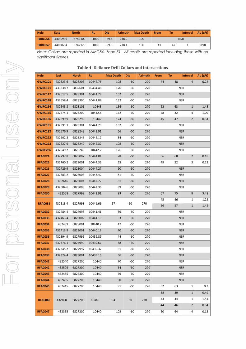
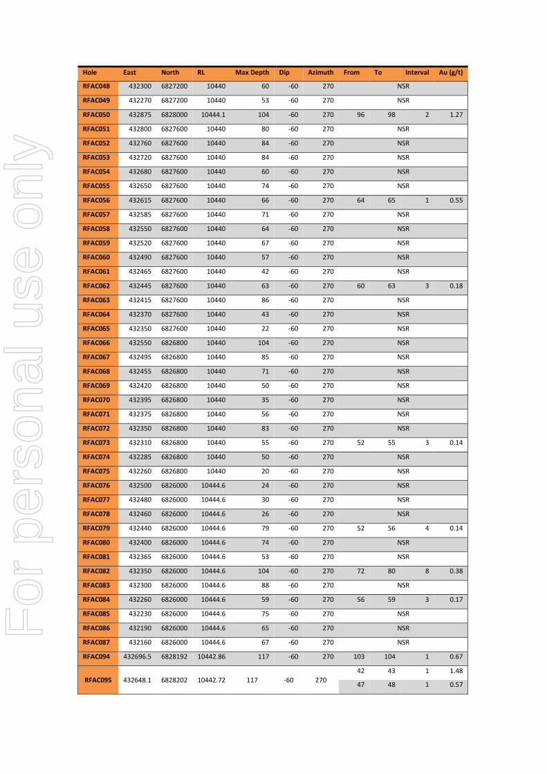
Table 4: Defiance Drill Collars and Intersections
Hole East North RL Max Depth Dip Azimuth From To Interval Au (g/t)
GWRC101 432623.6 6828203 10442.76 108 -60 270 44 48 4 0.22
GWRC121 433838.7 6832601 10434.48 120 -60 270 NSR
GWRC147 432617.5 6828301 10441.79 102 -60 270 NSR
GWRC148 432658.4 6828300 10441.89 132 -60 270 NSR
GWRC164 432643.2 6828101 10443 156 -60 270 62 63 1 1.48
GWRC165 432674.1 6828200 10442.8 162 -60 270 28 32 4 1.09
GWRC166 432699.9 6828299 10442 174 -60 270 45 47 2 0.34
GWRC181 432591.1 6828301 10441.73 102 -60 270 NSR
GWRC182 432576.9 6828248 10441.91 66 -60 270 NSR
GWRC222 432602.3 6828248 10442.12 84 -60 270 NSR
GWRC223 432627.9 6828249 10442.32 108 -60 270 NSR
GWRC286 432649.2 6828249 10442.2 126 -60 270 NSR
RFAC024 432797.8 6828007 10444.04 78 -60 270 66 68 2 0.18
RFAC025 432760.2 6828001 10444.36 55 -60 270 49 52 3 0.13
RFAC026 432729.9 6828004 10444.27 90 -60 270 NSR
RFAC027 432683.2 6828003 10443.42 81 -60 270 NSR
RFAC028 432646 6828004 10442.72 81 -60 270 NSR
RFAC029 432604.6 6828008 10442.36 89 -60 270 NSR
RFAC030 432558 6827999 10441.91 93 -60 270 67 75 8 3.48
RFAC031 432513.4 6827998 10441.66 57 -60 270 45 46 1 1.22
56 57 1 1.45
RFAC032 432484.4 6827998 10441.41 39 -60 270 NSR
RFAC033 432463.4 6828002 10441.13 53 -60 270 NSR
RFAC034 432439 6828001 10440.7 47 -60 270 NSR
RFAC035 432413.9 6828001 10440.13 40 -60 270 NSR
RFAC036 432394.9 6827995 10439.89 44 -60 270 NSR
RFAC037 432376.1 6827990 10439.67 48 -60 270 NSR
RFAC038 432345.2 6827997 10439.37 51 -60 270 NSR
RFAC039 432324.4 6828001 10439.16 56 -60 270 NSR
RFAC041 432540 6827200 10440 70 -60 270 NSR
RFAC042 432505 6827200 10440 64 -60 270 NSR
RFAC043 432485 6827300 10440 69 -60 270 NSR
RFAC044 432465 6827200 10440 90 -60 270 NSR
RFAC045 432445 6827200 10440 91 -60 270 62 63 1 0.3
RFAC046 432400 6827200 10440 94 -60 270
38 39 1 0.49
43 44 1 1.51
44 46 2 0.34
RFAC047 432355 6827200 10440 102 -60 270 60 64 4 0.13
For
per
sona
l use
onl
y
Hole East North RL Max Depth Dip Azimuth From To Interval Au (g/t)
RFAC048 432300 6827200 10440 60 -60 270 NSR
RFAC049 432270 6827200 10440 53 -60 270 NSR
RFAC050 432875 6828000 10444.1 104 -60 270 96 98 2 1.27
RFAC051 432800 6827600 10440 80 -60 270 NSR
RFAC052 432760 6827600 10440 84 -60 270 NSR
RFAC053 432720 6827600 10440 84 -60 270 NSR
RFAC054 432680 6827600 10440 60 -60 270 NSR
RFAC055 432650 6827600 10440 74 -60 270 NSR
RFAC056 432615 6827600 10440 66 -60 270 64 65 1 0.55
RFAC057 432585 6827600 10440 71 -60 270 NSR
RFAC058 432550 6827600 10440 64 -60 270 NSR
RFAC059 432520 6827600 10440 67 -60 270 NSR
RFAC060 432490 6827600 10440 57 -60 270 NSR
RFAC061 432465 6827600 10440 42 -60 270 NSR
RFAC062 432445 6827600 10440 63 -60 270 60 63 3 0.18
RFAC063 432415 6827600 10440 86 -60 270 NSR
RFAC064 432370 6827600 10440 43 -60 270 NSR
RFAC065 432350 6827600 10440 22 -60 270 NSR
RFAC066 432550 6826800 10440 104 -60 270 NSR
RFAC067 432495 6826800 10440 85 -60 270 NSR
RFAC068 432455 6826800 10440 71 -60 270 NSR
RFAC069 432420 6826800 10440 50 -60 270 NSR
RFAC070 432395 6826800 10440 35 -60 270 NSR
RFAC071 432375 6826800 10440 56 -60 270 NSR
RFAC072 432350 6826800 10440 83 -60 270 NSR
RFAC073 432310 6826800 10440 55 -60 270 52 55 3 0.14
RFAC074 432285 6826800 10440 50 -60 270 NSR
RFAC075 432260 6826800 10440 20 -60 270 NSR
RFAC076 432500 6826000 10444.6 24 -60 270 NSR
RFAC077 432480 6826000 10444.6 30 -60 270 NSR
RFAC078 432460 6826000 10444.6 26 -60 270 NSR
RFAC079 432440 6826000 10444.6 79 -60 270 52 56 4 0.14
RFAC080 432400 6826000 10444.6 74 -60 270 NSR
RFAC081 432365 6826000 10444.6 53 -60 270 NSR
RFAC082 432350 6826000 10444.6 104 -60 270 72 80 8 0.38
RFAC083 432300 6826000 10444.6 88 -60 270 NSR
RFAC084 432260 6826000 10444.6 59 -60 270 56 59 3 0.17
RFAC085 432230 6826000 10444.6 75 -60 270 NSR
RFAC086 432190 6826000 10444.6 65 -60 270 NSR
RFAC087 432160 6826000 10444.6 67 -60 270 NSR
RFAC094 432696.5 6828192 10442.86 117 -60 270 103 104 1 0.67
RFAC095 432648.1 6828202 10442.72 117 -60 270
42 43 1 1.48
47 48 1 0.57
For
per
sona
l use
onl
y

Hole East North RL Max Depth Dip Azimuth From To Interval Au (g/t)
RFAC096 432599.2 6828202 10442.59 99 -60 270
68 71 1 1.98
72 73 1 0.68
74 75 1 1.27
RFAC097 432600 6827800 10440 111 -60 270
62 63 1 1.84
64 72 8 0.37
RFAC098 432570 6827800 10440 85 -60 270
56 60 4 0.15
84 85 1 0.13
RFAC099 432550 6827800 10440 79 -60 270
52 60 8 0.23
68 72 4 0.29
RFAC100 432530 6827800 10440 73 -60 270
39 40 1 5.47
60 64 4 0.1
RFAC101 432505 6827800 10440 72 -60 270 44 48 4 0.22
RFAC102 432485 6827800 10440 65 -60 270 NSR
RFAC103 432465 6827800 10440 54.2 -60 270 NSR
RFAC104 432445 6827800 10440 47 -60 270 NSR
RFAC106 432577.6 6828203 10442.42 76 -60 270 NSR
RFAC107 432558 6828202 10442.28 59 -60 270 NSR
RFAC108 432143 6826400 10440 51 -60 270 NSR
RFAC109 432190 6826400 10440 60 -60 270 44 60 16 0.74
RFAC110 432075 6826400 10440 64 -60 270 NSR
RFAC111 432420 6827800 10440 50 -60 270 NSR
RFAC112 432395 6827800 10440 60 -60 270 NSR
RFAC113 432370 6827800 10440 42 -60 270 NSR
RFRC001 432539.4 6827998 10441.84 102 -60 270 81 92 11 0.5
RFRC002 432563.7 6828003 10441.35 120 -60 270
68 71 3 2.28
102 103 1 6.13
RFRC003 432494.1 6828004 10442 114 -60 270 NSR
RFRC004 432274.8 6826001 10444.61 150 -60 270 NSR
RFRC005 432488.5 6827901 10440.65 108 -60 270
60 62 2 2.03
78 80 2 2.32
RFRC006 432529.6 6827901 10441.35 120 -60 270
32 33 1 1.81
72 73 1 5.9
93 94 1 2.48
111 112 1 5.01
RFRC007 432537.9 6828101 10442.46 102 -60 270 NSR
RFRC008 432579.5 6828101 10442.94 120 -60 270
92 94 2 1.87
96 97 1 3.26
RFRC009 432603.2 6828100 10442.9 180 -60 270 104 109 5 1.26
RFRC010 432598.5 6828005 10442.3 180 -60 270
100 104 4 1.12
129 130 1 5.31
RFRC011 432464.9 6827896 10440.4 84 -60 270 67 68 2 1.94
RFRC013 432245 6826200 10440 120 -60 269 NSR
RFRC014 432210 6826400 10440 96 -60 271 NSR
RFRC015 432250 6826400 10440 108 -60 271 NSR
For
per
sona
l use
onl
y

Hole East North RL Max Depth Dip Azimuth From To Interval Au (g/t)
RFRC016 432230 6826600 10440 108 -60 270 NSR
RFRC017 432250 6826800 10440 114 -60 271 NSR
EMRC001 432784.7 6828160 10442.9 180 -60 90 86 87 1 2.12
EMRC002 432759.9 6828060 10443.6 108 -60 90 83 85 2 0.86
EMRC003 432760.2 6827960 10444.3 180 -60 90
61 62 1 1.28
64 66 2 1.23
72 74 2 0.63
EMRC004 432734.8 6827861 10441.7 180 -60 90 60 61 1 0.77
Note: Collars are reported in MGA94- Zone 51. All results are reported including those with no
significant figures.
For
per
sona
l use
onl
y

APPENDIX 2: JORC CODE, 2012 EDITION- SECTION 1
Section 1 Sampling Techniques and Data (Criteria in this section apply to all succeeding sections.)
Criteria JORC Code explanation Comments
Sampling
techniques
Nature and quality of sampling (eg cut
channels, random chips, or specific
specialised industry standard measurement
tools appropriate to the minerals under
investigation, such as down hole gamma
sondes, or handheld XRF instruments, etc).
These examples should not be taken as
limiting the broad meaning of sampling.
Mt Howe Project
The mineralisation is sampled by RC drilling
on initial 320m line spacing with lines
orientated perpendicular to the structure at
080O, 40m spaced holes angled at 60O
towards SE. A total of 197 RAB holes were
drilled at 50 mete hole spacing, 400 metre
line spacing and east-west lines. A total of
65 RC holes have been drilled to a
maximum depth of 100m. Holes were drilled
angled at 60O towards west.
Defiance Project
The mineralisation is sampled by AC drilling
on initial 400m line spacing with lines
orientated perpendicular to the structure at
090O, 30m spaced holes angled at 60O
towards 270. A total of 98 AC holes were
drilled at 50 mete hole spacing, 400 metre
line spacing and east-west lines. A total of
12 RC holes have been drilled to a
maximum depth of 170m. Holes were drilled
angled at 60O towards west.
Unknown Project
The mineralisation is sampled by two 200m
spaced east – west fences of RAB drill
traverses across the strike of the
mineralisation. Holes were angled 60O
towards 090. 16 holes were drilled at 25m
spacing.
Include reference to measures taken to
ensure sample representivity and the
appropriate calibration of any measurement
tools or systems used.
No quality control measures have been
documented.
Aspects of the determination of
mineralisation that are Material to the Public
Report. In cases where ‘industry standard’
work has been done this would be relatively
simple (eg ‘reverse circulation drilling was
used to obtain 1 m samples from which 3 kg
was pulverised to produce a 30 g charge for
fire assay’). In other cases more explanation
may be required, such as where there is
coarse gold that has inherent sampling
problems. Unusual commodities or
mineralisation types (eg submarine nodules)
may warrant disclosure of detailed
information.
Mt Howe Project
Drilling was used to obtain one metre
samples which were geologically logged to
determine mineralised intervals. Samples of
RAB holes were initially collected as 4m
composites, followed up by 1m splits over
anomalous Au zones. The samples were
sent to Analabs Laboratory in Perth for
analysis. Samples were crushed, dried, and
pulverised to produce a representative
sub-sample for analysis by AAS for Au and
XRF for As.
Samples of RC holes were initially collected
as alternative 1m composites, to ALS
(Kalgoorlie) for Au by 50g fire assay and XRF
for As.
Defiance Project
Drilling was used to obtain one metre
samples which were geologically logged.
Samples of RC holes were collected as 1m
intervals. The samples were sent to
Kalassay Laboratory in Kalgoorlie for
analysis. Samples were crushed, dried, and
pulverised to produce a representative
sub-sample for analysis by aqua regia for
For
per
sona
l use
onl
y

Criteria JORC Code explanation Comments
Au.
Unknown Project
No information in regards to the sampling
and assay techniques
Drilling
techniques
Drill type (eg core, reverse circulation,
open-hole hammer, rotary air blast, auger,
Bangka, sonic, etc) and details (eg core
diameter, triple or standard tube, depth of
diamond tails, face-sampling bit or other
type, whether core is oriented and if so, by
what method, etc).
No information in regards to drilling details
or drill companies was provided within the
Wamex reports.
Drill sample
recovery
Method of recording and assessing core
and chip sample recoveries and results
assessed.
Drill samples recovery was assessed visually
and recorded onto a logging sheet.
Measures taken to maximise sample
recovery and ensure representative nature of
the samples.
Mt Howe Project
RC Drill samples passed through a cyclone
and rotary splitter to ensure a
representative sample was taken.
Defiance Project
RC Drill samples passed through a cone
splitter to ensure a representative sample
was taken.
Unknown Project
No information in regards to the
representivity of the samples was provided
Whether a relationship exists between
sample recovery and grade and whether
sample bias may have occurred due to
preferential loss/gain of fine/coarse material.
No relationship between sample recovery
and grade has been established.
Logging
Whether core and chip samples have
been geologically and geotechnically
logged to a level of detail to support
appropriate Mineral Resource estimation,
mining studies and metallurgical studies.
All drill chip samples were geologically
logged to the level of detail required to
support a Mineral Resource Estimation.
Whether logging is qualitative or
quantitative in nature. Core (or costean,
channel, etc) photography.
The logging conducted in qualitative.
The total length and percentage of the
relevant intersections logged.
All drill holes have been logged in full.
Sub-
sampling
techniques
and
sample
preparation
If core, whether cut or sawn and
whether quarter, half or all core taken.
No diamond drilling was conducted.
If non-core, whether riffled, tube
sampled, rotary split, etc and whether
sampled wet or dry.
Mt Howe Project
RC Drill samples passed through a cyclone
and rotary splitter to ensure a
representative sample was taken.
Defiance Project
RC Drill samples passed through a cone
splitter to ensure a representative sample
was taken.
Unknown Project
No information in regards to the sampling
method was provided
For
per
sona
l use
onl
y
Criteria JORC Code explanation Comments
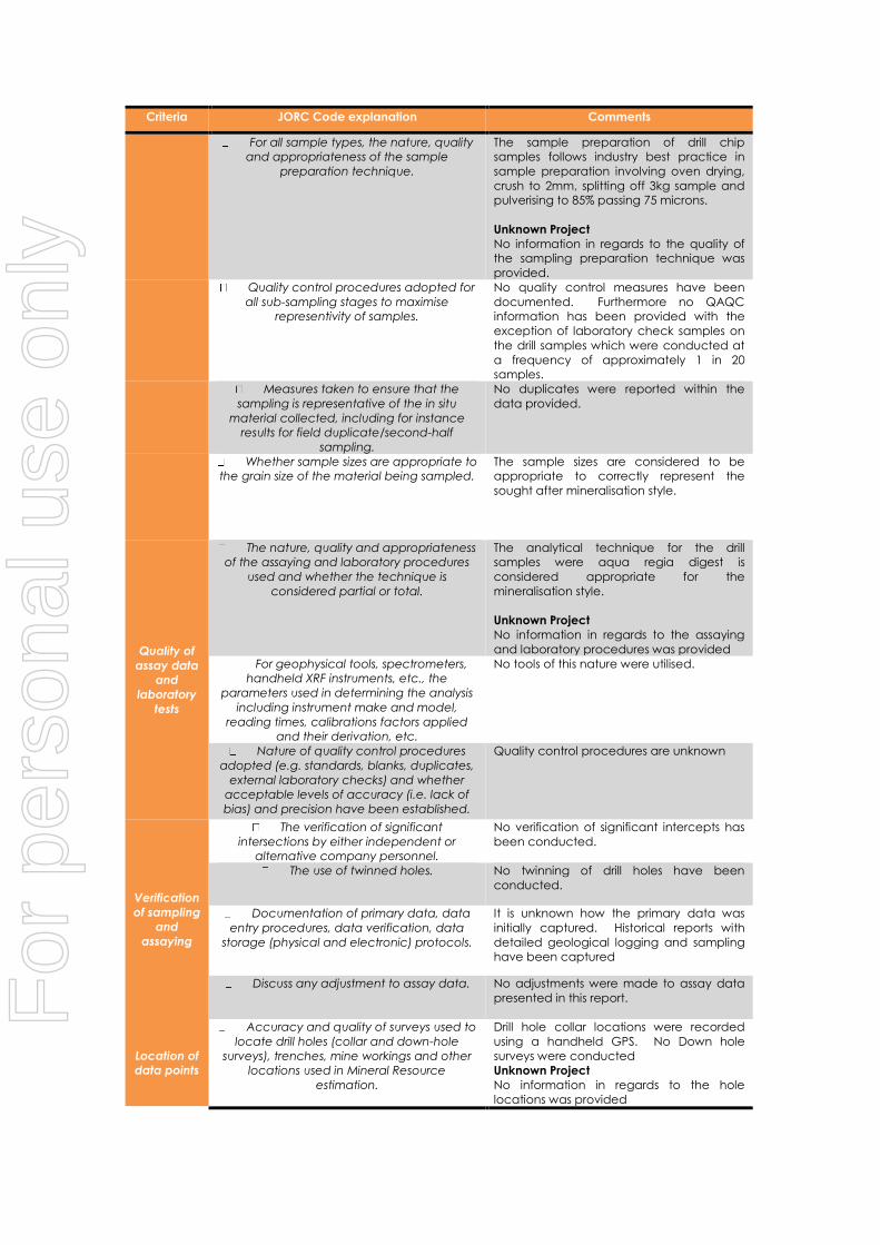
For all sample types, the nature, quality
and appropriateness of the sample
preparation technique.
The sample preparation of drill chip
samples follows industry best practice in
sample preparation involving oven drying,
crush to 2mm, splitting off 3kg sample and
pulverising to 85% passing 75 microns.
Unknown Project
No information in regards to the quality of
the sampling preparation technique was
provided.
Quality control procedures adopted for
all sub-sampling stages to maximise
representivity of samples.
No quality control measures have been
documented. Furthermore no QAQC
information has been provided with the
exception of laboratory check samples on
the drill samples which were conducted at
a frequency of approximately 1 in 20
samples.
Measures taken to ensure that the
sampling is representative of the in situ
material collected, including for instance
results for field duplicate/second-half
sampling.
No duplicates were reported within the
data provided.
Whether sample sizes are appropriate to
the grain size of the material being sampled.
The sample sizes are considered to be
appropriate to correctly represent the
sought after mineralisation style.
Quality of
assay data
and
laboratory
tests
The nature, quality and appropriateness
of the assaying and laboratory procedures
used and whether the technique is
considered partial or total.
The analytical technique for the drill
samples were aqua regia digest is
considered appropriate for the
mineralisation style.
Unknown Project
No information in regards to the assaying
and laboratory procedures was provided
For geophysical tools, spectrometers,
handheld XRF instruments, etc., the
parameters used in determining the analysis
including instrument make and model,
reading times, calibrations factors applied
and their derivation, etc.
No tools of this nature were utilised.
Nature of quality control procedures
adopted (e.g. standards, blanks, duplicates,
external laboratory checks) and whether
acceptable levels of accuracy (i.e. lack of
bias) and precision have been established.
Quality control procedures are unknown
Verification
of sampling
and
assaying
The verification of significant
intersections by either independent or
alternative company personnel.
No verification of significant intercepts has
been conducted.
The use of twinned holes. No twinning of drill holes have been
conducted.
Documentation of primary data, data
entry procedures, data verification, data
storage (physical and electronic) protocols.
It is unknown how the primary data was
initially captured. Historical reports with
detailed geological logging and sampling
have been captured
Discuss any adjustment to assay data. No adjustments were made to assay data
presented in this report.
Location of
data points
Accuracy and quality of surveys used to
locate drill holes (collar and down-hole
surveys), trenches, mine workings and other
locations used in Mineral Resource
estimation.
Drill hole collar locations were recorded
using a handheld GPS. No Down hole
surveys were conducted
Unknown Project
No information in regards to the hole
locations was provided
For
per
sona
l use
onl
y
Criteria JORC Code explanation Comments
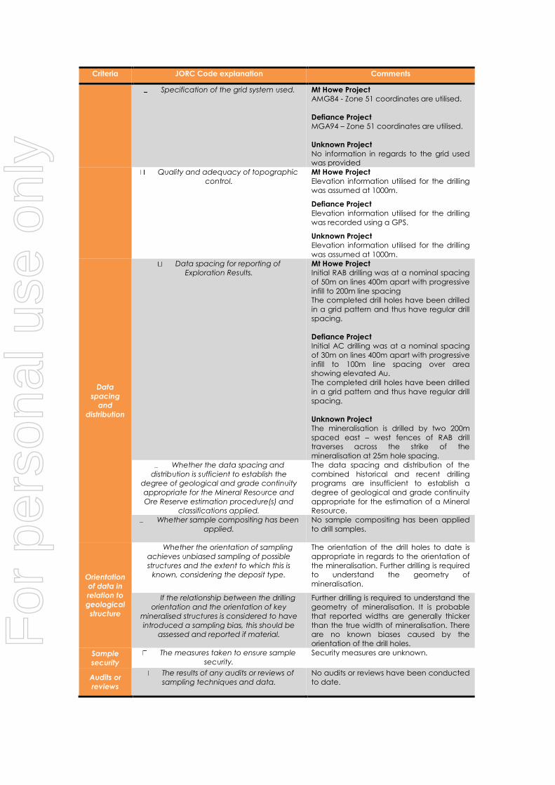
Specification of the grid system used. Mt Howe Project
AMG84 - Zone 51 coordinates are utilised.
Defiance Project
MGA94 – Zone 51 coordinates are utilised.
Unknown Project
No information in regards to the grid used
was provided
Quality and adequacy of topographic
control.
Mt Howe Project
Elevation information utilised for the drilling
was assumed at 1000m.
Defiance Project
Elevation information utilised for the drilling
was recorded using a GPS.
Unknown Project
Elevation information utilised for the drilling
was assumed at 1000m.
Data
spacing
and
distribution
Data spacing for reporting of
Exploration Results.
Mt Howe Project
Initial RAB drilling was at a nominal spacing
of 50m on lines 400m apart with progressive
infill to 200m line spacing
The completed drill holes have been drilled
in a grid pattern and thus have regular drill
spacing.
Defiance Project
Initial AC drilling was at a nominal spacing
of 30m on lines 400m apart with progressive
infill to 100m line spacing over area
showing elevated Au.
The completed drill holes have been drilled
in a grid pattern and thus have regular drill
spacing.
Unknown Project
The mineralisation is drilled by two 200m
spaced east – west fences of RAB drill
traverses across the strike of the
mineralisation at 25m hole spacing.
Whether the data spacing and
distribution is sufficient to establish the
degree of geological and grade continuity
appropriate for the Mineral Resource and
Ore Reserve estimation procedure(s) and
classifications applied.
The data spacing and distribution of the
combined historical and recent drilling
programs are insufficient to establish a
degree of geological and grade continuity
appropriate for the estimation of a Mineral
Resource.
Whether sample compositing has been
applied.
No sample compositing has been applied
to drill samples.
Orientation
of data in
relation to
geological
structure
Whether the orientation of sampling
achieves unbiased sampling of possible
structures and the extent to which this is
known, considering the deposit type.
The orientation of the drill holes to date is
appropriate in regards to the orientation of
the mineralisation. Further drilling is required
to understand the geometry of
mineralisation.
If the relationship between the drilling
orientation and the orientation of key
mineralised structures is considered to have
introduced a sampling bias, this should be
assessed and reported if material.
Further drilling is required to understand the
geometry of mineralisation. It is probable
that reported widths are generally thicker
than the true width of mineralisation. There
are no known biases caused by the
orientation of the drill holes.
Sample
security
The measures taken to ensure sample
security.
Security measures are unknown.
Audits or
reviews
The results of any audits or reviews of
sampling techniques and data.
No audits or reviews have been conducted
to date.
For
per
sona
l use
onl
y
APPENDIX 3: JORC CODE, 2012 EDITION- SECTION 2
SECTION 2 REPORTING OF EXPLORATION RESULTS
(Criteria in this section apply to all succeeding sections.)
Criteria JORC Code explanation Commentary
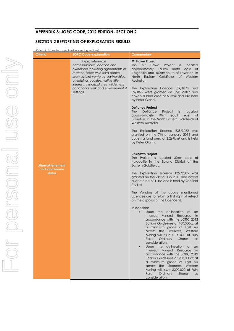
Mineral tenement
and land tenure
status
· Type, reference
name/number, location and
ownership including agreements or
material issues with third parties
such as joint ventures, partnerships,
overriding royalties, native title
interests, historical sites, wilderness
or national park and environmental
settings.
Mt Howe Project
The Mt Howe Project is located
approximately 160km north east of
Kalgoorlie and 100km south of Laverton, in
North Eastern Goldfields of Western
Australia.
The Exploration Licences 39/1878 and
39/1879 were granted on 07/01/2016 and
covers a land area of 5.7km2 and are held
by Peter Gianni.
Defiance Project
The Defiance Project is located
approximately 10km south east of
Laverton, in the North Eastern Goldfields of
Western Australia.
The Exploration Licence E38/3062 was
granted on the 7th of January 2016 and
covers a land area of 2.267km2 and is held
by Peter Gianni.
Unknown Project
The Project is located 30km east of
Kalgoorlie in the Bulong District of the
Eastern Goldfields.
The Exploration Licence P27/2005 was
granted on the 21st of July 2011 and covers
a land area of 11Ha and is held by Redfield
Pty Ltd
The Vendors of the above mentioned
Licences are to retain a first right of refusal
on the disposal of the Licence(s).
In addition:
Upon the delineation of an
Inferred Mineral Resource in
accordance with the JORC 2012
Edition Guidelines of 100,000oz at
a minimum grade of 1g/t Au
across the Licences, Western
Mining will issue $100,000 of Fully
Paid Ordinary Shares as
consideration.
Upon the delineation of an
Inferred Mineral Resource in
accordance with the JORC 2012
Edition Guidelines of 200,000oz at
a minimum grade of 1g/t Au
across the Licences, Western
Mining will issue $200,000 of Fully
Paid Ordinary Shares as
consideration.
For
per
sona
l use
onl
y

Criteria JORC Code explanation Commentary
· The security of the tenure
held at the time of reporting along
with any known impediments to
obtaining a licence to operate in
the area.
The licences are granted, no impediments
relating to the development of the Projects
have been identified.
Exploration done by
other parties
· Acknowledgment and
appraisal of exploration by other
parties.
Mt Howe Project
Numerous previous operators, including
Goldfields Ltd (previously Pancontinental
Mining Ltd)
Defiance Project
Numerous previous operators, including
Focus Minerals.
Unknown Project
Cyprus Gold Australia conducted the
exploration activities under the Bulong Joint
Venture.
Geology
· Deposit type, geological
setting and style of mineralisation.
Mt Howe Project and Defiance Project
The Projects are is located within the
southern portion of the Laverton Tectonic
Zone (LTZ). The LTZ is interpreted as a zone
of structural complexity and deformation,
with a predominant north-south trend,
bounded in the east and west by weakly
deformed rocks of the Merolia and Murrin-
Margaret sectors.
The project is prospective vein gold
mineralisation styles.
Depths of weathering along the
mineralised zone varies between 15-80m
and transported cover ranged between 0-
40m.
Unknown Project
The Project is located within the Gindalbie
Terrane of the Archaean Norseman Wiluna
Greenstone Belt.
Mineralisation within the project area
occurs as a series of lodes at the
intersection of a north trending vertical
shear zone and a flatly dipping structure.
Drill hole Information
· A summary of all information
material to the understanding of
the exploration results including a
tabulation of the following
information for all Material drill
holes:
The drill holes reported in this report have
been reported using a 0.1 g/t Au minimum
reporting grade.
o easting and northing of
the drill hole collar
Mt Howe Project and Defiance Project
Coordinates are reported in AMG84-Zone
51.
Unknown Project
Co-ordinates were reported in the Cyprus
Bulong Local Grid
o elevation or RL (Reduced
Level – elevation above sea level in
metres) of the drill hole collar
Mt Howe Project
RL is assumed at 1000m
Defiance Project
RL was recorded from a GPS
Unknown Project
RL is assumed at 1000m
For
per
sona
l use
onl
y

Criteria JORC Code explanation Commentary
o dip and azimuth of the
hole
Dip is the inclination of the hole from
horizontal (i.e. a hole drilled vertically down
from the surface is -90⁰). Azimuth is
reported in degrees as the direction
towards which the hole is drilled.
o down hole length and
interception depth
Down hole length of the hole is the
distance from the surface to the end of the
hole, as measured along the drill trace.
Interception depth is the distance down
the hole as measured along the drill trace.
Intersection width is the downhole distance
of an intersection as measured along the
drill trace.
o hole length. Hole length is the distance from the surface
to the end of the hole, as measured along
the drill trace.
· If the exclusion of this
information is justified on the basis
that the information is not Material
and this exclusion does not detract
from the understanding of the
report, the Competent Person
should clearly explain why this is the
case.
All results relating to the drill sections
provided have been stated including "No
significant intercepts".
Data aggregation
methods
· In reporting Exploration
Results, weighting averaging
techniques, maximum and/or
minimum grade truncations (eg
cutting of high grades) and cut-off
grades are usually Material and
should be stated.
All reported assays have been length
weighted.
· Where aggregate intercepts
incorporate short lengths of high
grade results and longer lengths of
low grade results, the procedure
used for such aggregation should
be stated and some typical
examples of such aggregations
should be shown in detail.
Sample lengths from RC drilling are all 1m
lengths.
Sample lengths from RAB holes were 4m
composites
· The assumptions used for any
reporting of metal equivalent
values should be clearly stated.
No Metal equivalents are reported.
Relationship between
mineralisation widths
and intercept lengths
· These relationships are
particularly important in the
reporting of Exploration Results.
The mineralisation is interpreted to be
steeply dipping and drill holes have been
angled (either vertical or at 60 degrees) It is
probable that mineralisation widths have
been reported as thicker than the actual
width of mineralisation given the modelled
lode is steeply dipping, and the majority of
the drill holes are vertical.
· If the geometry of the
mineralisation with respect to the
drill hole angle is known, its nature
should be reported.
Mt Howe Project
The geometry of the mineralisation is
inferred from limited drilling intercepts,
which suggests a NNW striking, steep ENE
dipping lode. The majority of the drill holes
intersecting the modelled lode are angled
towards grid west
Defiance Project
The geometry of the mineralisation is
inferred from limited drilling intercepts,
For
per
sona
l use
onl
y
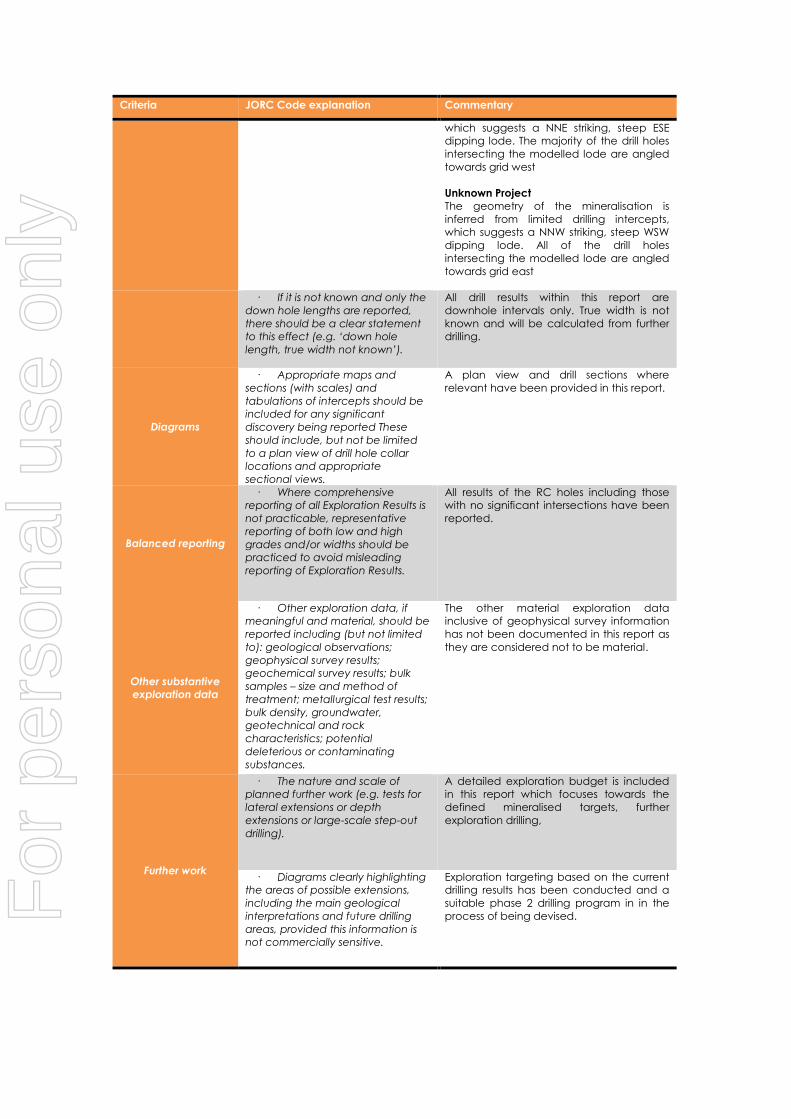
Criteria JORC Code explanation Commentary
which suggests a NNE striking, steep ESE
dipping lode. The majority of the drill holes
intersecting the modelled lode are angled
towards grid west
Unknown Project
The geometry of the mineralisation is
inferred from limited drilling intercepts,
which suggests a NNW striking, steep WSW
dipping lode. All of the drill holes
intersecting the modelled lode are angled
towards grid east
· If it is not known and only the
down hole lengths are reported,
there should be a clear statement
to this effect (e.g. ‘down hole
length, true width not known’).
All drill results within this report are
downhole intervals only. True width is not
known and will be calculated from further
drilling.
Diagrams
· Appropriate maps and
sections (with scales) and
tabulations of intercepts should be
included for any significant
discovery being reported These
should include, but not be limited
to a plan view of drill hole collar
locations and appropriate
sectional views.
A plan view and drill sections where
relevant have been provided in this report.
Balanced reporting
· Where comprehensive
reporting of all Exploration Results is
not practicable, representative
reporting of both low and high
grades and/or widths should be
practiced to avoid misleading
reporting of Exploration Results.
All results of the RC holes including those
with no significant intersections have been
reported.
Other substantive
exploration data
· Other exploration data, if
meaningful and material, should be
reported including (but not limited
to): geological observations;
geophysical survey results;
geochemical survey results; bulk
samples – size and method of
treatment; metallurgical test results;
bulk density, groundwater,
geotechnical and rock
characteristics; potential
deleterious or contaminating
substances.
The other material exploration data
inclusive of geophysical survey information
has not been documented in this report as
they are considered not to be material.
Further work
· The nature and scale of
planned further work (e.g. tests for
lateral extensions or depth
extensions or large-scale step-out
drilling).
A detailed exploration budget is included
in this report which focuses towards the
defined mineralised targets, further
exploration drilling,
· Diagrams clearly highlighting
the areas of possible extensions,
including the main geological
interpretations and future drilling
areas, provided this information is
not commercially sensitive.
Exploration targeting based on the current
drilling results has been conducted and a
suitable phase 2 drilling program in in the
process of being devised.
For
per
sona
l use
onl
y