Embed Size (px)
Citation preview

Working Group Reports
A-l
A.O CLIMATE AND WEATHER WCHKING GRDUP REKRT
A. 1
A.2
A.3
A.4
IntroductionStatus of Present OARS ApplicationsRequirementsPromising OARS TechniquesA.4. 1 Ocean Acoustic TanographyA.4.2 Shipboard Do~ler Acoustic Current ProfilerA.4. 3 Echaneter
A.4.4 Inverted Echo Sounder IES!A.4.5 WOTAN Weather Observation Through Ambient Noise!A.4. 6 Bottcxn-Based Acoustic SoundingReccemenda tionsA.5
A.I Introduction
Ocean data for climate research and prediction can be grouped intotwo general categories: monitoring and geophysical "experiments." Muchof what is presently known of the factors involved in climate variation isderived frcm empirical analyses of historical atmospheric, hydrologic, andoceanographic data. sets. Statistical analyses of these data sets as theyare improved are the best hope for successfully accurate seasonal andinterannual climate prediction. On the other hand, improvenent of skillin such forecasts, and the ability to make credible forecasts of climaticconditions in response to influences outside the range of recenthistorical experience, is critically dependent upon improvement of thestate of the art of deterministic modeling of the coupled ocean/atmosphere/cryosphere system. This improvement cannot cane franmathematics and computer technology alone, but rather fran a balancedprogram of modeling and observations. Parameterization of many geo-physical processes and testing of physical hypotheses in many cases cannotproceed frcxn the necessarily sparse data sets that can be collectedroutinely through rmnitoring. More intensive sets of observations focused
Ocean acoustic remote sensing is highly acxnplementary to oceanremote sensing fran satellite, which has received considerably more, andmore well-organized, attention in that it offers great promise forproviding subsurface data. The electranagnetic spectrum used in satelliteremote sensing is limited to observations at or very near to the oceansurface. For the same reason, ocean acoustic ramte sensing appears to beconsiderably more relevant for data collection required for climateresearch and prediction than for weather. It is quite generally acceptedthat subsurface oceanographic data are not essential data for short-termweather forecasting. There are, however, certain weather-related surfacephenomena, such as wind waves, or wind stress, whose presence might beeffectively observed far below the surface.

A-2
on specific objectives are required for this purpose. Rrperiments such asMODE, PQLYMODE, GATE, FGGE, NCRPAX, etc. demonstrate the pattern of suchstudies.
A.2 Status of Present OARS Applications
Up to the present, there has been no use of ocean acoustic ranotesensing for systematic ocean monitoring for weather and climate, and onlya. few instances of their use in related geophysical experiments. Of thetechniques discussed in Section A.4, the inverted echo sounder has beenused in anvil numbers since 1973. It may now be considered a proveninstrument. Shipboard doppler shear profilers and the WOTAN WeatherObservation 'Ihrough Ambient Noise! have been tested at sea and showexcellent promise for use in both long-term monitoring and specialexperiments. Preparations are now underway for the first serious test ofocean acoustic tunography. This test in itself will require a geophysicalexperiment of same considerable proportions. During the next decade, themost likely application for this technique is in special experiments. Itis potentially attractive for sampling oceanographic processes in whichthe most energetic temporal and spatial variations are important.Depending upon associated cases, it may subsequently meet requirements foroperational collection of this type of data.
A.3 Requirements
Because a. considerable body of documents now exists on the subject ofocean monitoring for climate studies, and because there was reasonableagreement among the manbers of the Working Group on the kinds of oceanclimate observation that are becaning critical, the discussion ofrequirements was limited. Reference is made particularly to the NOAAClimate Plan, the National Five-Year Climate Plan, and "An Ocean ClimateResearch Plan" ERI !.
Briefly, the requirements for physical oceanographic parameters inclimate lie in the following areas:
o Sea Surface Temperature
In terms of relative priority, sea surface temperature is the keyoceanic parameter to be monitored for shorter time sca,les, because itcontrols the transfer of thermal energy fram the ocean to the atmosphereand therefore has a direct and inmediate effect on the climate system.
o Upper Iayer Heat Content
In order to understand and eventually to predict the large-scale,long-term variability of sea surface temperature, it is necessary tomonitor the heat content of the upper "heat storage" layer of the ocean.In the context of these discussions, particular emphasis is placed onprofiles of temperature and current through the mixed layer, and mappingof temperature and current! fields.

A-3
o Wind Stress
Wind stress exerted upon the surface of the oceans is the majordriving force that maintains the prevailing ocean currents which in turnplay a significant role in the horizontal transport of heat energy fromthe tropics to the poles. It also generates the surface waves and swellsthat are responsible for downward mixing of heat that accumulates at thesurface, thereby increasing the thickness of the heat-storage layer andmaking way for tmre heat to be stored. Wind stress therefore affects thearmunt and distribution of thermal energy in the ocean, and, because windstress on the ocean detexmines surface roughness, it is fundamental tomodeling air-sea interactions, particularly with regard to boundary layerheat transfer.
o Sea Level and Sea Surface Tomography
Sea level is a sensitive indicator of long-term global climatechange, and measurements of local sea level dynamic height! variabilityin the open ocean are extrl:ly useful for monitoring climaticailysignificant fluctuations of major ocean currents and upper layer heatcontent.
o Ocean Currents
As in the atmosphere, understanding and rmnitoring the generalcirculation of the ocean is an important step toward understanding andpredicting the climate. Although the general circulation has been studiedfor many years, there is no definitive picture of the global movanent ofwater, which to a large degree controls the flux of heat energy. Seealso Upper Layer Heat Content.!
o Sea Ice
Sea ice is particularly sensitive to climatic conditions, varyingover a year fran almost total coverage of the Arctic Ocean in the coldmonths to about 60% coverage at the end of the sunmer. Nearly three-fourths of the incaning radiation frcm the sun is reflected by the ice,while only about one-tenth is reflected fran open water. The rmainder isabsorbed. The ice cover thus drastically reduces heat exchange as well asmass exchange between ocean and a~here.
o Salinity
Salinity is a significant ocean climate variable in that itdetermines the freezing point of sea water and affects the densitystructure hence circulation! of the ocean.
In focusing the discussions on the use of OARS for meeting theserequirements, the Working Group found the most i<mediate promise in theareas of upper layer heat content and circulation currents!, sea level,and wind stress observations. Within the category of heat content andcirculation, the ccmbined acquisition of temperature and dynamicinformation received repeated and continued anphasis.
A-4
The Working Group also concluded, as noted in the introduction, thatthe applications of OARS to weather requirements were not extensive. 'Iherequirements for near-real-time data on wind velocity, sea state, andprecipitation over ocean areas were the major weather applicationshighlighted in the discussions.
A.4 Premising OARS Techniques
Acoustic remote sensing techniques show considerable prcxnise forocean environmental applications. Tclacgraphy, if successful, will permitthe mapping of pund speed and temperature structure over large oceanareas �000 km! , and fram the temperature field significant inforrmtioncan be derived about the flow. Several doppler shear profilers are underdevelopnent which will ultimately make possible the rapid continuousabsolute measurement of shear profiles in an upper ocean frcm surfaceships or bottcmed transducers. The echaneter, proposed by the WavePropagation Laboratory for atmospheric applications, should make possiblethe continuous measurement of temperature profiles in the upper ocean fromsurface ships or bottomed transducers, and the possibility exists for itobtaining the shear profile as well. The inverted echo sounder, currentlyin an advanced state of developnent, when calibrated initially usingconventional techniques, can measure mean heat content in the watercolunn, a quantity of considerable interest to the climate program.
The ocean-bottled ambient noise measuring equi@vent N7ZAN hasoperated successfully in the field for some time and can be used currentlyfor estimating wind speed and mean wind stress, quantities obtained in theopen ocean only with considerable difficulty. It shows pranise for freeand anchored buoy operations as well, although these would be newapplications of the technology. The Wave Propagation Laboratory has alsosuggested the use of acoustic instrumentation for the measurenent ofdirectional ocean wave spectra although this concept again is notcurrently under developnent.
The discussion that follows provides considerably more informationabout these concepts, addressing current studies and plans, whatinstitutions are involved, the potential for successful developnent ifnot already demonstrated!, developnent needs, and sane development programmilestones.
A.4.1 Ocean Acoustic Tomography A Schane for Large-Scale h4nitoring!
Observations during the last two decades have demonstrated that mostof the kinetic energy of the ocean circulation is associated withvariability on a relatively +nail scale the mesoscale! of order 100 km.Measuring this variability poses a formidable problem because of the smallspatial scale ccrnpounded by the long ocean time scale of order 100 days.Ocean acoustic tomography is a potential technique to monitor the oceansby measuring acoustic trananissions between moorings over large distancesof order several hundred kilcmeters. The procedure consists of measuringperturbations in travel time between a number of acoustic sources andreceivers, and then inverting these perturbations in travel time to obtainthe interior sound speed structure. The structure in the vertical is
A-5
obtained because there exist a+ay purely refracted ray paths for eachsource-receiver pair that sample different parts of the water colm@i andtherefore have different travel time perturbations. Because the number ofpieces of information is the product of the number of sources, receivers,and resolvable multipath arriva,S,, the economics of the system is enhancedover usual spot measurenents.
Dr. W. Munk of Scripps Institution of Oceanography, Dr. R. Spindel ofWoods Hole Oceanographic Institution, Dr. C. Wunsch of MassachusettsInstitute of Technology, and Dr. J. Birdsa.ll of the University of Michiganare currently involved in a joint effort to test the feasibility of oceanacoustic tomography. Experiments conducted during 1978 and 1979 havedemonstrated that the ocean multipath structure is stable at least over aperiod of a few months, that the ray paths can be adequately resolvedusing existing acoustic sources with approximately 20 Hz bandwidths, andthat the travel time perturbations can be measured with 10 ms precision,which is more than adequate for monitoring mesoscale fluctuations. Theyare therefore proceeding with a full three-dimensional test that will takeplace in the Atlantic for a period of four months early in 1981. Thisexperiment will provide concanitant acoustic and oceanographicobservation adequate to address the first inversion problem of thetemperature field, and to begin work on the second inversion problen ofthe flow field. Four source moorings and five receiver moorings will beinstalled to monitor a 300 km by 300 }an area. NOAA ACMI.! will play animportant role in this experiment by conducting CTD surveys of the area atthe beginning, middle, and end to provide conventional data for comparisonwith the acoustic data and will participate in other oceanographic aspectsof the project. Analysis of the data fran this experiment is expected tobe ccmpleted within two years.
While the data analysis is proceeding, the investigators plan toexplore the possibility of using two-way acoustic trananissions to monitorocean currents, to examine techniques to obtain the data on shore in realtime e.g., by long-range acoustic telanetry or by satellite link!, tostudy the feasibiity of building sufficiently stiff moorings to eliminatethe need to track mooring motion, and perhaps to monitor the horizontaldeflections of ray paths as a possible input to the acoustic inversionproblem.
If the 1981 experiment is successful, an experiment to apply thetechnique to another oceanographic problem will be conducted in 1983.Possible candidate experiments include an equatorial experiment to monitorthe undercurrent meanders perhaps in conjunction with the EquatorialPacific Ocean Climate Studies EHXS! work!; an experiment to monitor thecold water overflow through the Denmark Straits, and an experiment tomonitor the Gulf Stream recirculation. Personnel and equipnent resourcesare probably sufficient to conduct this experiment.
Xn roughly 1985-86 an order of magnitude increase in experiment sizeto 1 meg Uneter squared fran the 0.1 megameter squared 1981 experiment istentatively planned.
A-6
Ocean acoustic tcm~phy has potential application to sampling andmapping of oceanographic sound velocity temperature! and currentstructure in regions that by rein of size and spatial and temporalva,riability cannot be adequately sampled by means of conventional shipcurrent meters or other methodology. Ebssible application includesconduct of specia,l investigations of the dynamics of ocean circulation andheat flux. Its best application will probably require concomitantobservation of sea level by altimetric satellite or other means ofdetermining the absolute pressure or current fields. Such methodologiesmay be critical for a successful Atlantic heat flux determination.
A number of develolxnental needs have been identified and some arebeing addressed. Foremost among these are questions of determining theseveral mund paths with sufficient accuracy, the stability of these pathsover periods of several months, and the accuracy with which the traveltime data can be inverted to produce maps of sound velocity ontempera'~. Secondary problems concern the secondary inversion of thederived temperature data to obtain flow fields, and possible applicationof the method to oceanic regions which do not have a prominent soundchannel.
Probable Milestones:
1981 1983 1985
Oceanographicexperiment, use oftechnique for research,experiment with recip-rocal tranHnissions
1000 km square deploy-ment, 15-24 moorings forocean circulation, heattransport
300 km squareexperiment, 9 mooringsfor four months
MODE area!
A.4.2 Shipboard R>ppler Acoustic Current Profiler
Vertical profiles of current velocity over much of the world's oceanscan be obtained at relatively low cost by employing ships of opportunityequipped with suitably modified doppler speed logs.
This instrument utilizes four high-frequency narrow acoustic beams,each inclined 30 to the vertical fore, aft, port, and starboard! toobtain a high resolution profile of horizonta,l currents to a depth of 100to 200 meters beneath the ship. Estimates of the horizontal velocity ofsuccessive layers in the water colenn are made by subtracting the doppler-shifted backscatter of each layer from the bottan return, thus giving avertical profile of absolute horizontal current velocities.
In the deep ocean, where the bottom return is not available becauseof signal attenuation, the Global Tbsitioning System may possibly serve asa means for providing a, reference velocity. An alternative approach,known as the Parametric Array Mppler Sonar, obtains bottcm returns evenRt extreme depths by mixing two high-frequency colinear beams to form a.single acoustic beam that has the range capability of the low beat!frequency with the narrow beam characteristics of the high primaryfrequencies.
A-7
At the present time several workers are experimenting with dopplerunits built by Ametek-Straza, including Lloyd Regier a.t Scripps and BobHill at NRL. John Pijan~ of 5QAA/NOS is testing a. unit built for NCAAby the French Company, ~son C.S.P. None of these instruments ispresently capable of providing absolute current profiles in deep water,although the Parametric Array Doppler Sonar can be modified for thispurpose,
%he disadvantage of the Doppler Acoustic Current Profiler is itsdependence on scatterers in the water colm' for coherent doppler signals.Scatterers in sufficient concentrations are noxme.lly present only in theupper several hundred meters. However, this is the region of greatestinterest for climate purposes! since it is where most of the heat energyis stored and is also the region of greatest variability due to surfacewind stress.
The advantage of the Doppler Acoustic Current Profiler is that it canoperate unattended while the ship is underway; it can be integrated aspart of the SEAS Shipboard Environmental Data Acquisition Systan! systemcurrently being developed for NQAA/NWS use aboard cooperative ships, andshould be acceptable to ccemercial ship operators, since doppler speedlogs are familiar navigational devices aboard modern ships. Indeed, theaddition of an absolute current profiling capability would enhance aship's navigation capabilities by providing a true velocity readout evenin deep water, which present systems do not.
Suggested Milestones:
1981 19831981
Begin integration for Install experimentalshipboard applications. systan aboard NOAA ship
for field tests inconjunction with heatflux experiments.
Begin developnent ofAcoustic Current
Velocity Profiler.
A.4.3 Echaneter
With reference to Figure 1, p. A-8, an echaneter consists of atransmitting array or a pa.ir of transmitting arrays combined with a singlereceiver for simultaneous correction and measurement of ocean currentprofiles. The transmitting arrays consist of two or more transducersspaced several wavelengths apart. Such a spaced array produces adirectivity pattern that contains a number of beam-like constructiveinterference fringes. These 3-dimensional interference fringes act likesound channels through which the major part of the transmitted energyflows. Ordinarily, the axis of the transmitting arrays would bepositioned pointing vertically downward. The various interferencefringes, however, would be positioned at increasing angles inclined to thearray axis. A narrow beam fran the receiver would also point vertica.llydownward from a point considerably distant--perhaps a whole shiplength � fran the transmitting array. The exact distance chosen woulddepend on the depth to which temperature and current profiles are desired.The receiver beam would intersect the transmitted fringes at a number of

A-8
tachometer Geoimetry
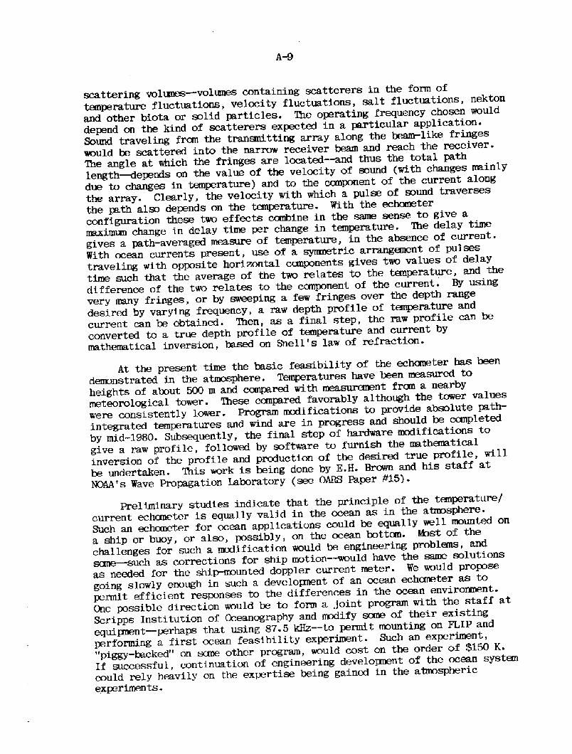
scattering volmms � volumes containing scatterers in the form oftemperature fluctuations, velocity fluctuations, salt fluctuations, nektonand other biota or solid particles. 'Ibe operating frequency chosen woulddepend on the kind of scatterers expected in a, particular application.Sound traveling fran the transmitting array along the beam-like fringeswould be scattered into the narrow receiver beam and reach the receiver.The angle at which the fringes are located � and thus the total pathlength � depends on the value of the velocity of sound with changes ma,inlydue to changes in temperature! and to the component of the current a.longthe array. Clearly, the velocity with which a pulse of sound traversesthe pa,th aim depends on the temperature. With the echometerconfiguration these two effects combine in the same sense to give amaxinnm change in delay time per change in temperature. The delay timegives a path-averaged measure of temperature, in the absence of current.With ocean currents present, use of a symmetric arranganent of pulsestraveling with opposite horizontal canponents gives two values of delaytime such that the average of the two relates to the temperature, and thedifference of the two relates to the ccmponent of the current. By usingvery many fringes, or by sweeping a few fringes over the depth rangedesired by varying frequency, a raw depth profile of tanperature andcurrent can be obtained. Then, as a final step, the raw profile can beconverted to a true depth profile of temperature and current bymathematical inversion, based on Snell's law of refraction.
At the present time the basic feasibility of the echaneter has beendemonstrated in the atmosphere. Temperatures have been measured toheights of about 500 m and compared with measurement fran a nearbymeteorological tower. 'Ihese compared favorably although the tower valueswere consistently lower. Prog~ modifications to provide absolute path-integrated temperatures and wind are in progress and should be ccxnpletedby mid-1980. Subsequently, the final step of hardware modifications togive a raw profile, followed by software to furnish the mathenaticalinversion of the profile and production of the desired true profile, willbe undertaken. This work is being done by E.H. Brown and his staff atNOAA's Wave Propagation Laboratory see OARS Paper 115!.
Preliminary studies indicate that the principle of the tm!perature/current echaneter is equally valid in the ocean as in the atmosphere.Such an echometer for ocean applications could be equally well mounted ona ship or buoy, or also, possibly, on the ocean bottcln. hhst of thechallenges for such a modification would be engineering problens, andsane � such as corrections for ship motion � would have the same solutionsas needed for the shi~unted doppler current meter. We would proposegoing slowly enough in such a developnent of an ocean echcmeter as topermit efficient responses to the differences in the ocean environment.One possible direction would be to form a joint pmgvm with the staff atScripps Institution of Oceanography and modify some of their existingequipnent � perhaps that using 87.5 kHz- � to permit mounting on FLIP andperforming a first ocean feasibility experiment. Such an experiment,"piggy-backed" on sane other program, would cost on the order of $150 K.If successfu}., continuation of engineering developnent of the ocean systancould rely heavily on the expertise being gained in the atmosphericexperiments.

Proceeding with the developnent of a prototype ocean tanperaturejcurrent depth profiler is estimated to take an additional two to threeyears and require approximately $500 K- Field testing might very well behandled by a NQAA oceanographic group or by scrrre outside oceanographicinstitution.
Suggested Milestones
Cclrrplete Ocean Feasibility ExperimentCcmplete Atmospheric Raw Profile PrototypeCcrmplete Total Prototype Atmospheric SystemCamplete Total Prototype Oceanic System
Ja.nuary 1981July 1981January 1982January 1984
A.4.4 Inverted Echo Sounder IES!
The IES is an ocean-bottan moored instrrmrent which tranarrits andreceives acoustic pings to measure the travel time to the ocean surfaceand back precisely. Variations in the travel time arise due to variationsin the water depth caused by tmtion of the free surface, and due tochanges in the sound speed associated with changes in the mean tanperaturein the water colons.
Instruments employing this technique were used in applications duringthe MidE3cean Dynamics Experiment MODE! and subsequently in the GulfStream to monitor the depth of the main thermocline and the dynamic heightthrough the main thexmocline with an accuracy of 1 dynamic cm, i.e.,canparable wi/h the best standard hydrographic techniques Watts andRossby, 1977! . In that same paper the technique is shown to be wellsuited for monitoring variation in the heat content in the water column.The instr~nts can operate in depths to 7000 m for up to a year. De/.ilsof the instrrxrrent design are surrmarized in Bitterman and Watts �979!
Watts, D. Randolph and H. Tlxxnas Rossby �977!. "Measuring &gramicHeight with Inverted Echo Sounders in MODE." Jour. Physical Oceanog.,Vol. 7, pp. 345-358.
Bitterman, Ehvid and D. Randol+ Watts �979!. 'Ihe Inverted EchoSounder." IEEE/MTS Oceans '79 Proceedings, pp. 302-311-
Watts, D. Randolph and Donald B. Olson �978!. "Cbalescence of aGulf Stream Ring with the Gulf Stream off Cape Hatteras." Science,Vol. 202, pp. 971-972.
These instruments are presently being used by Watts of URI to studyGulf Stream meanders in an array designed to measure variability in thepath and structure of the Gulf Stream as it leaves the continental marginoff Cape Hatteras. Meanders grow and propagate downstream of this region;these experiments seek to test whether they may be linked to perturbationat the "inlets� " See Watts and Olson, 1978.! Recently other IES's havebeen deployed by Miller URI! and Katz Lamont! in the equatorial AtlanticOcean to study equatorially trapped modes of oscillation.
Nine additional instrunents are presently under construction fordeployment in the EPOCS experiment to monitor variation in the heatcontent of the water colann and to study whether sea surface temperatureanatelies in that region represent significant changes in ocean heatstorage or are merely near-surface readjustments of heat distribution.
The technique of measuring acoustic travel time in the IESconfiguration holds pranise for a nmiber of applications beyond itspresently demonstrated capability. These include:
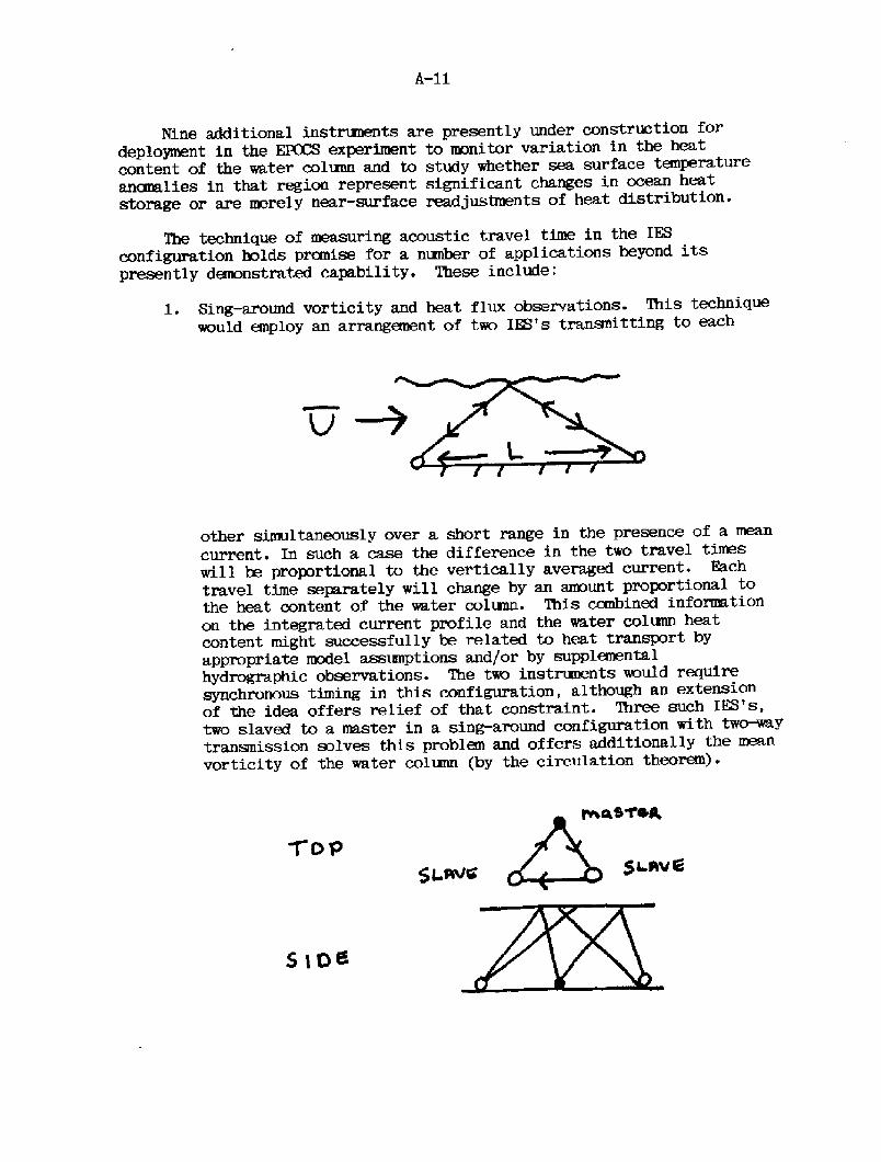
1. Sing-around vorticity and heat flux observations. %his techniquewould employ an arranganent of two IES's trananitting to each
other simultaneously over a short range in the presence of a meancurrent. In such a case the difference in the two travel timeswill be proportional to the vertically averaged current. Eachtravel time separately will change by an armunt proportional tothe heat content of the water colunn. This combined informa.tionon the integrated current profile and the water colunn heatcontent might successfully be related to heat transport byappropriate model assumptions and/or by supplanentalhydrographic observations. The two instrmmnts would requiresynchronous timing in this configuration, although an extensionof the idea offers relief of that constraint. Three such IES's,twc slaved to a master in a sing-around configuration with tw~ytransmission solves this problem and offers additionally the meanvorticity of the water colunn by the circulation theorem!.
2. Use with bottom pressure observations to determine free surfaceposition deepwater tide! and the depth of the thermocline. Thismarriage of techniques is both inst@mentally feasible andscientifically desirable. The bottan pressure and changes inacoustic travel time are variables that can be expressedanalytically in terms of free surface variations and internalwater mass characteristics.
3- Observation of the shape of the return pulse fry an IES,particularly the rising edge, to give sea state information inanalogy with the satellite radar.
4. hhnitoring of arctic ice sheet thickness during the winter, framthe safety of the ocean bottan using an IES.
Suggested Milestones:
1980 Begin IES in EPOCS.
1981 Use of IES in tomography experiment for transmission acrossGulf Stream; incorporate bottcm pressure sensor in IES; beginin developnent of second generation microprocessor! IKS.
1983 Begin trial vorticity/heat flux application of IES.
1985 Use of IES to support calibration of satellite altimeter alonglines across Gulf Stream during large-scale systemsevaluations.
A.4.5 WOTAN Weather Observation Through Ambient Noise!
Through the use of a passive acoustic receiver located on the oceanbottom or at rnid-depth on a nuoring, it has been damnstrated thatmeasu~nts of wind speed and wind stress on the sea surface can be madeby mnitoring noise levels in the 4-20 kHz range. Accuracies of + 2. 5 m/sor better are possible, down to wind speeds of 2.5 m/s or lower. Byusing a range of frequencies it is also possible, in principle, todetermine rate of precipitation.
Two prototypes of this instrument now exist. However, the presentdesign is very simple and easily duplicated. At least one manufacturermy be interested in producing operational versions of the device. Inaddition to potential applications fran fixed stations for weatherobservation and ocean/a~here research, the device may prove to be acandidate for wind observations fran drifting buoys. At present, littleis known of the full range of uses to which such systans might be applied.Extensive testing is now required in experiments that provide independentobservations of wind stress, wave conditions, wind speed, andprecipitation rate.
Suggested Milestones:
1981 Initiate plan for research into ~AN techniques.Use in conjunction with acoustic tanography moorings.
1983 Test for use with drifting buoys as wind speed sensor.
1985 Use with satellite altimeter.
Expand drifter measuz~nts.
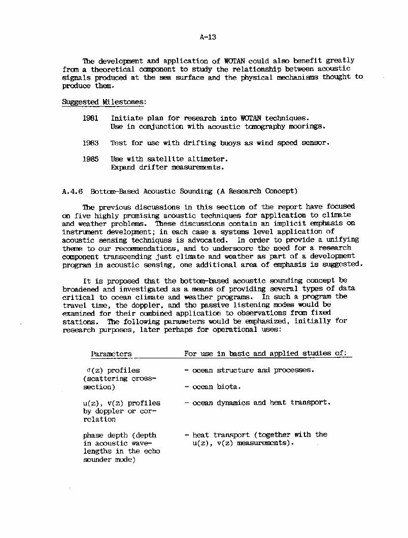
A.4.6 Bottom-Based Acoustic Sounding A Research Concept!
The previous discussions in this section of the report have focusedon five highly pranising acoustic techniques for application to climateand weather problems. These discussions contain an implicit anphasis oninstrument developnent; in each case a systems level application ofacoustic sensing techniques is advocated. In order to provide a unifyingthine to our reconnendations, and to underscore the need for a, researcheanponent transcending just climate and weather as part of a developnentprogram in acoustic sensing, one additional area of emphasis is suggested-
It is proposed that the bott~based acoustic sounding concept bebroadened and investigated as a means of providing several types of datacritical to ocean climate and weather programs. In such a program thetravel time, the doppler, and the passive listening modes would beexamined for their combined application to observations fran fixedstations. The following parameters would be emphasized, initially forresearch purposes, later perhaps for operationa,l uses:
For use in basic and applied studies of:
� ocean structure and processes.
- ocean biota.
� ocean dynamics and heat transport.
Parameters
< z! profiles scattering cross-section!
u z!, v z! profilesby doppler or cor-relation
� heat transport together with theu z!, v z! me~~nts!.
phase depth depthin acoustic wave-
lengths in the echosounder mode!
'Ihe development and application of %7ZAN could also benefit greatlyfrcm a theoretical canponent to study the relationship between acousticsignals produced at the sea surface and the physical mechanians thought toproduce them.
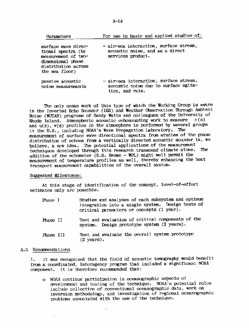
For use in basic and applied studies of:Parss.ters
� air-sea interaction, surface stress,acoustic noise, and as a directservices product.
surface wave direc-tional spectra bymeasurement of two-
dimensional phasedistribution across
the sea floor!
� air-sea interaction, surface stress,acoustic noise due to surface agita-tion, and rain.
~ssive acousticnoise measurements
Suggested Milestones:
At this stage of identification of the concept, levels-effortestimates only are possible.
Studies and analyses of each subsystem and optimumintegration into a single system. Design tests ofcritical parameters or concepts � year!.
Test and evaluation of critical canponents of thesystem. Design prototype systan � years!.
Phase II
Test and evaluate the overall system prototype� years!.
Phase I II
A. 5 Reccmnendations
1. It was recognized that the field of acoustic tomography would benefitfree a coordinated, interagency program that included a significant NOAAeanponent. It is therefore rec<xm nded that:
o NOAA continue participation in oceanographic aspects ofdevelopnent and testing of the technique. NOAA's potential rolesinclude collection of conventional oceanographic data, work oninversion methodology, and investigation of regional oceanographicproblans associated with the use of the technique.
The only ocean work of this type of which the Working Group is awareis the Inverted Echo Sounder IES! and Weather Observation 'Ihrough AmbientNoise WOTAN! programs of Randy Watts and colleagues of the University ofRhode Island. Atmospheric acoustic echosounding work to measure cr z!and u z!, v z! profiles in the atmosphere is performed by several groupsin the U.S., including NOAA's Wave Propagation Laboratory. Themeasurement of surface wave directional spectra from studies of the phasedistribution of echoes frcm a vertically directed acoustic sounder is, webelieve, a new idea. The potential applications of the measurementtechniques developed though this research transcend climate alone. Theaddition of the echometer K.H. Brown � WPL! might well permit themeasurement of temperature profiles as well, thereby enhancing the heattransport meam~ent capabilities of the overall system.

o %!AA initiate participation in acoustic aspects of the develop-ment. Xbssible tasks include investigation of long-term soundpath stability, telemetry, and the application of acoustic phaseon reciprocal trananission to special situations like variation ofthe Florida current. Gooperation with appropriate Navy interests,perhaps in joint use of island-based acoustic facilities, is alsosuggested.
o NOAA address the question of designing simple moorings of suffi-cient stability and durability for use in tancgraphic arrays. NOAAhas addressed similar needs in the past.
2. It is recarmended that a doppler current shear profiler be developedfor potential integration into an experimental shipboard package aboardone of the NOAA research ships. It is further reccnmended that theinstrument be evaluated extensively in conjunction with NOAA's Heat FluxExperiment and other appropriate field experiments such as EPOCS and thenconsidered for installation aboard cooperative ships as an integral partof the SEAS system.
3. %he potential for simultaneous depth profiling of temperature,current, and horizontal heat flow are so rewarding that a program tofurther develop the echometer should be undertaken. It is recmaandedthat:
o X!AA undertake continued experimentation with the atmcephericversion of the echaneter air@ed at translation of the informationgained to application in the ocean, and that a cooperative oceanfeasibility experiment be undertaken. If the latter is success-ful, full developnent and construction of an ocean echcmeter couldfollow irrmediately.
o The feasibility experiment proposed above be carried out coopera-tively with an experienced ocean ranote sensing group withavailable equiIxnent, such as Scripps Institution of Oceanography.
4. The inverted echo sounder has already danonstrated an ability tomonitor changes in heat content of the water colm'. The concept could beexpanded by using a small array of IKS's to me;~e "sin~round" soundvelocity, vorticity, and heat flux. Other possibilities include measure-ments of the IES pulse shape after scattering by the sea surface to deriveinformation on sea state. It is recarmended that:
o NOAA, working with the University of Rhode Island and othergroups, seek to expand the capabilities and use of the IKS forclimate research applications.
o NDAA consider subsequent developrent of a second generation devicefor use in long-term monitoring applications.
5. The potential of WEAN is exceedingly promising as an air-seainteraction research instrument, and also as an ocean climate monitoringdevice for example, if deployed over large scales on drifting buoys!-Accordingly, the following steps are recomoended;
o NQAA investigate developnent of a WOI'AN suitable for deployment aspart of an advanced drifting buoy sensor suit.
o NOAA plan for developnent of WOTAN in both bottom-mounted a.nddrifting buoy configurations, in conjunction with planned oceanresearch programs e.g., EPOCS, Ocean Heat Flux, PYREX! tosupplanent surface observations of wind and rainfall.
o NOAA encourage evolution of this technique through a program ofbasic research into the mechanians of ambient noise generation andtheir relationship to parameters such as sea state, wind stress,and precipitation.
6. Bottom-based acoustic sensors have already demonstrated the abilityto monitor parameters such as heat content of the water colunn, windstress, and minfall rate. Other parameters potentially measurable bysuch sensors include current velocity profiles as abave!, sea surfacedirectional spectra, internal wave directional spectra, and profiles ofacoustic back-scattering cross section. We recommend that:
o NOAA undertake a. multi-year research and developnent programcooperatively with universities and other agencies to explore andexploit the use of bottcxn-based acoustic sensors.
7. The Working Group noted that acoustic telemetry of data frcm a,subsurface platform was found to be a ccexmn requirement in a wide varietyof the develoInent programs under consideration. It is, therefore,recomnended that:
o 'Ihe requirements for acoustic telemetry for OARS be established,and the adequacy of current technology for meeting than beassessed.
o NOAA undertake support of a modest program to develop thenecessary capability.
8. Institutional and organizational mtters addressed by the WorkingGroup brought forth the following recamendations and observations beyondthose contained implicitly in the items above:
o The mix of pmogram interests, developnent organizations, andacoustic experts achieved by this workshop should be continued andreinforced by periodic meetings such as this one.
o A program in OARS for climate applications could be implanentedthrough existing organizational mechanians. 'Ihe program is bestfocused through its technologica.l strength and critical programneeds rather than through organizational issues.
o Coordination of individual NOAA efforts into an effective wholeand the careful relating of NOAA programs to those of otheragencies should be sought in implementing these OARSreconmendations.
Working GroupClimate and Weather
Dr. J. Michael Hall
Office of Ocean Engineering/NGAA
Asst. Chairman: Dr. Donald V. Hansen
Atlantic Oceanographic and MeteorologicalLaboratory/NOAA
Dr. John R. ApelEhcific Marine Environmental
Laboratory/NOAA
+ Mr. ~d H. Brown
Wave PropagationLaboratory/NOAA
Dr. Edward S. EpsteinNational Climate Program
Of f ice/NGAA
Mr. Robert Etkins
Office of Research andDevelopnent/NQAA
+ Dr. J.O. Fletcher
Environmental Research
laboratories/NOAA
*+ Dr. C. Gordon Little
Wave PropagationLaboratory/NOAA
~Member, Steering ComrLttee; +Speaker
Mr. Robert Iackerman
Environmental MtaIn formation Service/NOAA
Dr. Walter H. MonkInstitute of GeophysicsScripps Institution of
Oceanography
Dr. Alan O. SykesOffice of Naval Research
+ Dr. D. Randolph WattsGraduate School of
OceanographyUniversity of
Rhode Island
Dr. &ter WorcesterInstitute of GeophysicsScripps Institution of
oceanography
8-1
8. 0 FISHERIES WCBKING GROUP RFXCRT
C I'ZEFZiS
B.l Introduction
8.1.1
B.1
8.2
8.3
8.4
B.5
8.6
8.7
B.8
8.9
8.10
Introduction
NOAA OARS PolicyNOAA GARS R>licy-Level PanelNMFS OARS Fisheries F! PanelApplication of Accepted GARS/F TechniquesNMFS Specific Technical Developnents of OARS/FNOAA/Navy Technological CooperationSunmaryConclusions and Reccxmmdations
Rnnnary of Recaanendations
bean acoustic remote sensing OARS! is essentially a 20th-century phenanenon which began with sounding to the bottan anddetecting icebergs. For more than half the history of oceanicacoustics, fish-finding has been a major use of this technology.We use of GARS for fishery management purposes has been ~ngfor only 20 years. The fundamental "transparency" of turbid anddeep ocean regions to underwater sound guarantees that OARStechniques will grow as the method of choice for fisherymanagement problans on several important stocks of fish. Wepranpt developnent of OARS techniques will require a Ion~lastingcartnitment. The growing role of NOAA in fishery managanentrequires that NOAA take the lead in the U.S. for developing OARStechnology for the purpose of maintaining the optirmin sustainableyield of U.ST renewable fishery resources.
GARS techniques are very elaborate and specialized owing tothe vast expenditure of talent and amney in anti-sutmarinewarfare ASW! and seismic exploration of the seabed for oildeposits. The understanding of the OARS environment, research onsignal processing, and acoustic system integration willmaterially aid NOAA in the developnent of GARS techniques.
8.1.2 Scope of OARS Fisheries Report
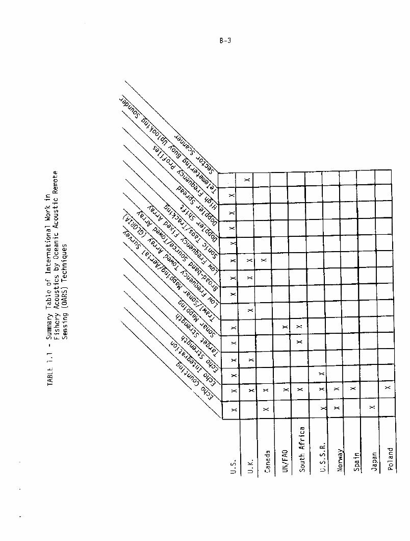
Several nations are involved in the developneat of OARStechniques for fishery problans and ten are listed in Table 1.1.The table lists 14 OARS procedures and the countries using theseprocedures on the high seas. While the U.S. would appear to leadtechnologically, the United Nations Food and AgricultureOrganization leads in the application of OARS technology tofishery evaluation. NOAA's largest investment in fishery
B-2
acoustics is a ccxnputerized dual beam echo integration systemwhich is nearly opera.tional in the Northern and NortheastPacific.
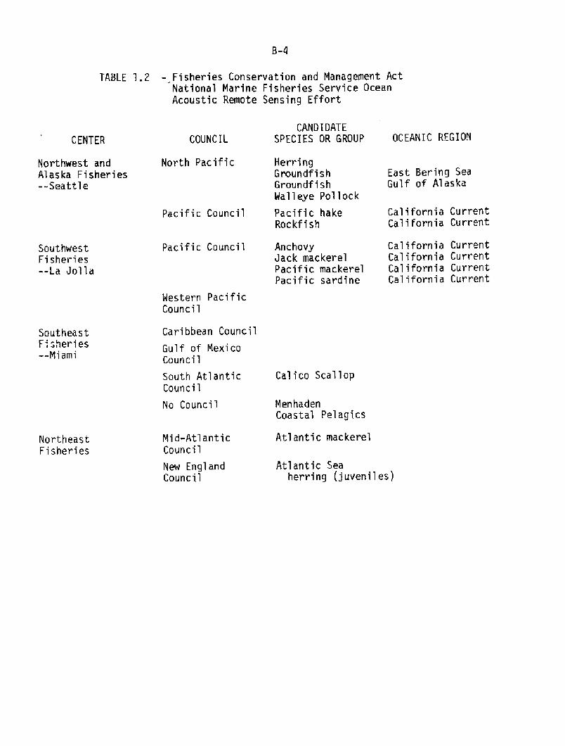
NOAA has the lead research responsibility in support of morethan 70 fishery rnanaganent plans to be implemented by eightregional management councils extending fran the North Pacific andWestern Pacific to the centuries-old fishing grounds off the NewEngland coast. By no means are all of these fisheries amenableto management or study by OARS techniques. Indeed, only 15species or species groups are identified at this time asimportant candidate-species for quantitative OARS developnentwork Table 1.2!. Of these, four are already being investigatedwith NOAA's developnental OARS system digital echo integration! ~Other species may never need the intense space-time continuityoffered by OARS techniques. Thus, we must ranain aware thatacoustic techniques will become an invaluable rnanaganent tool butnot a panacea for all fisheries problans.
Table 1.1. illustrates the diversity of acoustic equipnentfor fishery studies. The equipnent should be developed in anorderly fashion based on the need and value of the fish resourcesand their inherent variability and danger of overfishing. OARScounting of single large fish is already fully developed.Quantitative digital echo integration is now nearly operationa,lfor layers of fish containing 1 to 10 fish per cubic meter. Thechief problems which remain are identification of species andestimation of the biomass of pelagic schooling fishes.
B.1.3 Scope of This Report
This report represents the written deliberation of 17 of theleading U.S. scientists and engineers in the fields of fisheryassessment, management of fishery research, physics of underwaterand atmospheric sound, anti-sukmarine warfare ASW!, informationscience, and signal processing from acadanic, federal government,and industry laboratories. The group was assembled by the NOAAAssistant Adminstrators for Research and Develorxnent, Fisheries,and Oceanic and Atmospheric Services. The meetings were convenedfor four days after 3 months of preparation. This document isone, Fisheries, of four Climate and Weather, Ocean Pollution,Ocean Services! and extends from deliberations on researchmanagement policy in NOAA and Fisheries to applied andfundamental research and development in OARS.
B.2 NOAA OARS Policy
B.2.1 The basis for meaningful advancement of OARS will requiresane technological risk for the term of about one decade. Astated NOAE policy on OARS vuuld release inventiveness andtechnical reativity frcrn NOAA research groups and permitestablishment of effective ties to professors and graduatestudents of the top professional schools of this nation.
OEID
'rIN
C>O
r cC C5C OO
Ctt5 VlQ! 4JV
4C> 0
+ cCD%
Vl QJV +0 'r
D hr D CL~a ae
V O
C7!rd G
ahr
C/J ~ lA
LLJ
B-4
TABLE '].2 � Fisheries Conservation and Management ActNational Marine Fisheries Service OceanAcoustic Remote Sensing Effort
CAND I DATES P EC I E S OR GROUP OC EANI C RFG I ONCOUNCILCENTER
North PacificNorthwest andAlaska Fisheries--Seattle
East Bering SeaGulf of Alaska
California CurrentCalifornia Current
Pacific Council
Pacific CouncilSouthwestFisheries--La Joila
Western PacificCouncil
Caribbean CouncilSoutheast
F sheries--Miami
Gulf of MexicoCouncil
Cal i co Scallop
MenhadenCoastal Pelagics
Atlantic mackerelMid-AtlanticCouncil
NortheastFisheries
Atlantic Seaherring juvenilesj
New EnglandCouncil
South AtlanticCouncil
No Council
HerringGroundf i shGroundf i sh
Walleye Pollock
Pacific hakeRockf i sh
AnchovyJack mackerelPacific mackerelPacific sardine
California CurrentCalifornia CurrentCalifornia CurrentCalifornia Current
B-5
B.2.2Significant progress in fisheries acoustics can probably be
obtained with existing NOAA and NMFS personnel and technologicaland academic expenditures of less than 1% of the curIent NMFSbudget on an annual basis. Benefits would accrue fran increasedeffectiveness of ship time used for fishery managementinformation. Another source of benefits of OARS application isthat the inevitable collapse of some kinds of fish stocks couldbe discovered earlier and the consequences made less severe andless frequent. Such consequences would alleviate the idling offisheries capital investment, unemployment, and importation ofalternative murces of fish and protein. Another benefit wouldbe the rapid fishing response to rapidly growing fish stocks,with consumer benefits in lower protein prices.
B.2.3
Lastly, a NOAA policy could be cast to ensure a balancedprogram of environmental monitoring with Environmental ProtectionAgency EPA! and Coast Guard and fisheries managanent.
B.2.4
B.2. 5 Surnnary
A HDAA QARS developnent policy conmitment to a balancedprogram of developnent of OARS for environmental assessment andfisheries management would release the creative talents of NOAAscientists and engineers and their colleagues in the universitiesand industry. An OARS policy would also delimit responsibilitiesand specify periodic technical oversight to secure advances inOARS with a minimum of technological risk.
1. The NOAA OARS/1980 Fisheries Working Group concludesthat
a. the national OARS policy should anphasire long-rangebudget carrnitments required to secure NOAA/OARSbenefits;
b. the OARS policy must be a. balanced program ofenvironmental assessment and fisheries mnag~nt;and,
c. the OARS policy must be coordinated withelectranagnetic remote sensing in sr' phases.
2. 'late NOAA OARS/1980 Fisheries Working Group recoamendsthat a NOAA national policy statanent on OARS be issuedin support of research on acoustic r~te sensing in theocean.
A NQAA policy statanent on OARS could delimit thetechnological effort by resisting special interest demands. Alsoa policy could contain explicit requirements that Oceanpollution, Ocean Services, Climate and Weather, and Fisheriesavoid duplication of fundamental research necessary to implementGARS systems. A NOAA policy could designate 1iaison with NavyASW and with NOAA/NESS, NOAA/MUST Manned Undersea, Science andTechnology Office! to forestall duplication and waste.
8.3 NOAA OARS Policy-Level Panel
8.3.1 Scope of Amel Action
1. 'Ihe RNA policy level panel would focus on thoseportions of OARS development that dealt with fundal;ntalproperties, e.g., wave propagation.
2. Another responsibility of the NOAA OARS panel would bethe evaluation of technologica.l progress andeffectiveness of OARS within Fisheries, Ocean R!llution,Climate and Weather, and Ocean Services.
3. The OARS panel would foster liaison among NOAA agencies,with defense, international OARS, academic, andindustria.l laboratories.
The internal NQAA QARS panel would also assembleprofessional and technical expert panels at nodes and milestonesin the MMA QARS program. lastly, the NOAA OARS panel couldadvise the NOAA Administration on the desirability of having aNOAA QARS Program Manager during critical phases in the long-termdevelopnent of OARS technology.
8.3.2
8.3.3 'Ihe NDAA CRRS/1980 Fisheries Working Group concludes that:
1. current research, developnent, and applications workoccurs within several Main Line Cbeponents MLC's! inNOAA,
2. the OARS/1980 Workshop dmxmstrated a camnmity ofinterest in NOAA/OARS and includes our federal,academic, and industry colleagues; and
3. augmentation of research effort and effective planningis a likely outcome of regular interccnn~ication amongOARS and other specialists within NOAA.
8.4 NMFS OARS Fisheries F! Panel
8-4.1 Scope of Panel Action
One duty of the NMFS GARS/F Panel is to forwardreccemendations regarding studies of fundamental acousticproperties to the NOAA GARS panel for joint consideration withOARS/P, OARS/CW, and OARS/08 requirements in fundamental OARSadvancement. OARS/F also selects representatives to the NOAAOARS Panel.
8.3.4. We OARS/1980 Fisheries Working Group recomnends that a.NOAA/OARS panel be formed to foster interccmaunication among theprograms in NOAA.
1. The primary duty of GARS/F is to foster the developnentof OARS systems to accanplish NMFS missions.
2. QARS/F will also evaluate needs and progress in regionalOARS systan developnents and establish developnentalpriorities.
3. The OARS/F panel will also be responsible formaintaining liaison with international OARS efforts andoffer and elicit cooperative developnent, especiallywhere fish stocks cannon to U.S. and bordering countriesrequire data of uniform derivation and quality forinternational joint managanent.
4. It can be anticipated that OARS/F and GARS/P nayinteract broadly in areas where fisheries causepollution and pollution impacts fisheries.
OARS/F will assemble expert panels to review regionalapplications of GARS and set standards for verification ofeffectiveness of OARS/F regional and species OARS techniques inthe context of fishery managanent.
B.4.2
B.4.3 The OARS/1980 Fisheries Working Group concludes that:
1, QRS programs exist in NMFS which have demonstrated goodapplication potentials, but which require unified admini-strative and funding support.
2. Geographically varying differences in fish populations,environments, and needs for fishery managanent servicespreclude universa,l application of a specific OARStechnique.
3 ~ A focused and balanced national effort is needed withinNMFS to insure that adequate attention is given to OARSpotentia.ls and requirements in NMFS research planning.
The OARS/1980 Fisheries Working Group therefore renmmendsthat meetings of appropriate NMFS personnel be held to develop aplan for the application of OARS technology for NMFS missions,and that regular at least annual! meetings be held thereafter toevaluate progress and to provide planning advice to NMFS CenterDirectors.
B.4.4
B.5 Applica,tions of Accepted OARS F Techniques
There are instances of OARS/F techniques where no furtheracoustical or electronic developnent seams necessary. here are alsoOARS/F techniques where nerxls for further developnent of a sub-systemare not clear enough without consideration in the context of the fisherymanagement system of which OARS/F is only a part. We select threeexamples.

B.5.1
Autcmated sonar mapping is another method for rmnitoringstocks of schooled fish. In particular, the hliforniaDepartment of Fish and Game, with federal support, has monitoredthe northern anchovy for several years. They detected Mais,1974; Mais, in press! a threefold decline in the anchovy centralstock fram their surveys. Such surveys using sonar mapping,research pelagic tmwls, and monitoring of the ccxInercial catchhave much to offer in the developnent of population predictivecapability.
B. 5.3 Even rudimentary acoustic techniques offer added informationfor the design and refinenent of direct sampling. Sampling whichrequires expensive ship time and technica.l analysis can, intheory, be made much more efficient by formal a.llocation ofsampling effort using OARS/F techniques.
The Fisheries Working Group of OARS/1980 recognizes theexistence in each region of a limited number of key fisherymanagement problems which are now amenable to generalizedapplications of GARS techniques. For example:
B.5.4
1. Quantitative Digital Echo Integration is in the advanceddevelopnental/operational phase for single-speciesfisheries in the Northeast Pacific and Bering Sea;
2. Automated sonar mapping is available for schoolingpelagic fishes in relatively deep water greater than 50meters!;
3. Standard statistical techniques of double sampling allowOARS techniques to be used to allocate sampling of depthstrata in ecosystems, fish aggregations and otherlocalized phenanena in the oceans.
Quantitative digital echo integration and fish counting cannow be accanplished in a, survey mode with an existing OARS/Fdevelopment. For example, applications have been achieved duringa survey of the stock of herring residing in open wa.ter off theNorthern Washington~uthern Vancouver Island area. The totalbiaoass of herring estimated during this survey, which wa.sdistributed within three major aggregations, amounted to about205,000 metric tons MI'!. The Canadian estimate of the expectedreturn to the spawning grounds of the offshore canponent of thestock, based on a large series of spawning ground surveys, wasabout 180,000 MT, plus about 100,000 MT of juveniles that werenot necessarily in the surveyed area. The excess bicmassestimated by echo integration could be easily accounted for bymortality prior to their return to their spawning areas from 8 to10 rmnths after the survey. Offshore sampling indicated that few1-year-old fish were in the survey area at the time of datacollection. While this result supports the working capability ofecho integration, a time series should be established to test the"robustness" of the estimates.
The Fisheries Working Group of QARS/1980 re~ends thatcontinued application of accepted OARS techniques such as echointegration and sonar mapping be emphasized: �! to obtain thelong-term acoustic monitoring/prediction information essentia,l toeffect fish stock managanent, and �! to meet the need to bettercmanmicate the present and potential utility of acoustictechniques.
8. 5.5
B.6 NMFS Specific Technical Developments of QARS F
B.6.1 Classification and sizing of acoustic targets may beaccomplished by measuring acoustic resonance, doppler structureand in situ target strength. Experimental work with thesemethods has brought the techniques up to an engineering levelwhich supports the implanentation of prototype systans for fieldevaluation. Specific systems which should be considered forimplanentation are:
1. Wide band sparker/tawed array systems tailored toanchovy year-class classification and school sizing.
2. High resolution doppler/range processing for highfrequency �0-100 kHz! side-looking mapping sonars.
3. Calibrated dual beam sonars for quantitative acoustictarget strength measuranents.
8.6.2 Implementation of these systems should be followed by anextended program of data collection coordinated with biologicalsampling for species identification of observed acoustic targets.
1. Surveying coastal pelagic fish schools presents aproblem for. which acoustic techniques have a potentialapplicability. The shallow water environment introducesthe complication of ~ng by bottcm reverberation sothat the deep water mapping system cannot be usedeffectively. Investigation of the use of MZI movingtarget indicator! techniques which are used in the radarconmunity for ground clutter rejection, or the use ofhighly directional sonar beams using either large
Virtually all the OARS/F techniques developed so far usequantitative amplitude target strength! domain information to assesssize and abundance of fish, la,yers, and schools. The motion of a fishschool, the motion of the fish within the school, and the motion of fishbody parts all yield infozmation potentially useful for identifying thefish and assessing their behavior i.e., feeding, migrating, escaping! ~The presence or absence of an air bladder is an important classificationcriterion and if the air bladder is present the resonance of the bladderand the distribution of resonance frequency in a school allows a usefulestimate of fish size, an important population parameter.
aperture or parametric transducers should point the wayto the implementation of a shallow wa,ter fish schoolmapping system.
2. Larval Fish/Zooplankton SaJnpl ing
There are two current research approaches in thisa.rea: �! IIowed backscatter arrays �00-250 kHz! lookvertically down and can sample the upper water column <200 m! continuously. The net system position can bemonitored continuously and located in relation toacoustic features WHOI, A M!, �! On the other handhigher frequency ! 1 MHz! systems can be used a.lone orin conjunction with pumps or nets to sample a sma,lier �0 m3! volume of water UCSD, THACOR!. With such asystem continous profiling of a water column is notpossible nor can net location be continuously monitored.Furthermore, far greater resolution is attainable andthe probability of sizing and discriminating targets ishigher. Both types could and should be used to extendthe sampling volume surveyed by traditional gear. 1hesedevices are in the developmental stage but considerableresearch has been done and we estimate that with activecooperation fran current research groups they could beapplied within three years.
"Holistic" description is useful on several scales of spaceand time of fishery ecosystems.
Fishery ecosystem studies require simultaneous measurementsof environmental parameters as well as the different trophiclevels on a multi-species basis. 'Ihe monitoring of thesepa,rameters requires different time and area schedules. 'The basicstatistical design approach to such problems is a nested samplingdesign. Extensive developnent of nested approaches using directsaJnpling, QARS, and electromagnetic remote sensing techniques canbe done utilizing and adapting presently available technology.This developnent should provide the discipline for evaluation ofthe potential techniques and methods. While sampling design andevaluations is an ongoing project as newer technical tools becameavailable, initial input to improved effectiveness of samplingshould be possible within one year.
The Fisheries Working Group of OARS/1980 recognizes theexistence in each region of a. limited number of key fisheryproblems which are now amenable to specific technical developnentof QARS/F techniques. The economics of the operational use ofthese techniques should be evaluated as they are developed.
Identification, classification, or sizing of fish withinschool targets can be acccmplished using acousticresonance, doppler spread, and in situ target strength;
2. Cbastal pelagic schooling fish should be studied usingshallow water sonar mapping;
3. Abundance of larval fish and zooplankton could bedetexmined using acoustic high-frequency depth profiling;
4. Fishery ~stems could be observed on several scalesof space and time using nested sampling strategiesinvolving direct sampling, GARS, and electrcmagneticremote sensi.ng techniques; and therefore,
The Fisheries Working Group of QARS/1980 recoaxrends thatproject plans for specific technical developnent of OARStechniques be prepared and included in the MHPS GARS plan forevaluation by Center Directors and preparation of budgetinitiatives for 1983.
B.6.5
B. 7 NQAA/Navy Technological Cooperation
B.7.1 The Fisheries Working Group of GARS/1980 concludes that itis NOAA's responsibility to maintain a continuing program inresearch and developnent of GARS techniques and that muchexisting acoustic technology has not yet been attempted orevaluated in the context of fishery research. The applicabletechnology developed by the Navy is, as a matter of policy,unclassified and fully available as an information base forfisheries research. It is unrealistic, however, to acme thatthe Navy's implementation of the acoustic technology will satisfyNQAA needs in acoustic remote sensing.
Therefore, the NOAA GARS/1980 Workshop renmnends that NOAAcontinually monitor Navy acoustic technology but emplmsizes thatNOAA/OARS must assume full responsibility for research anddevelopnent of acoustic technology for fisheries andenvironmental monitoring problens.
B. 7.2
B. 8 Sunmary
To secure the benefits of lengthy, stable careitments totechnological developnent NOAA should consider a NOAA policy on OARS tobe implemented and motored by a NOAA GARS panel and such outsidereview as is required. The panel should have representation fromGARS/Fisheries, QARS/Pollution, GARS/Ocean Services and GARS/Climate andWeather. 'Ihe panel should manage major NOAA-wide projects acoustictomography! and other fundamental advances in GARS/Science. The panelshould delegate to OARS/F, etc. those matters of developnent,implementation, and regional allocation of effort. Both NOAA and %FSlevel panels should foster inter- and intra.-agency cooperation. Bothshould rely on academic and miltary OARS basic science and contractfunded development and at times implementation. There are certain well�developed acoustic techniques such as echo integration, sonar mapping,and acoustically directed sample allocation whose further developmentdepends on judicious trial applications within fishery management or
B. 9 Conclusions and Recmnendations
~ NQAA OARS/F Working Group concludes that:B.9. 1
A national GARS policy could use strong independentoversight and long-range budget cannitments required tosecure NOAA/OARS benef its;
An OARS policy must be a, balanced program ofenvironmental assessment and fisheries marmganent; and
2I
The OARS policy must be coordinated with electrcmagneticremote sensing in arne phases.
34
'Iherefore, it is rmmnended that a NOAA national policystatemeat on GARS be issued ia support of resea.rch onacoustic remote sensing in the ocean.
'Ihe MMA CARS/F Working Group concludes that:8.9.2
Current research, developnent, and applications workoccurs within several MLC's in NQAA;
It demonstrated a ccarnunity of interest in NOAA/OARSand includes our federal, acadenic, and industrialcolleagues;
2 ~
Augmentation of research effort aad effective planningis a likely outcane of regular interccaeunication amongGARS and other specia,lists within NOAA.
3 ~
Therefore, it is rexxrmended tha.t a NOAA/OARS panel beformed to foster interccmnunication among the programsin NOAA.
The GARS/F Fisheries Working Group concludes that:B.9.3
Scme OARS programs exist in NMFS which have danoastratedapplication potential but require unified administrativeand funding support;
Geographic differences in fish populations, environment,and needs for fishery management services precludeuniversal acceptability of specific OARS techniques; and,
2.
A focused and balanced national effort is needed withinNMFS to ensure that adequate attention is given to OARSpotential and requirements in NMFS research planning.
3.
research systems. There are also a. few frequeacyM~mn and high-frequency developtents worth advaacing to operational level. For theseGARS/F techniques and fundamental M3AA GARS advances, NOAA should acceptthe positan of lead U.S. agency.
8-13
'1herefore, it is recoaxrended that meeting of appropriateNMFS personnel be held to develop a plan forimplementation of OARS for NMFS missions, and thatregular at least annual! meetings be held thereafter toevaluate progress and to provide planning advice to %PSOenter Directors.
'Jhe GARS/F Working Group recognizes the existence in each
which are now amenable to generalized applications of OARStechniques. For sample there are '.
l. Quantitative digital echo integration which is in theadvanced developnental/operational phase for single-species fisheries in the Northeast Pacific and BeringSea;
2. Autanated sonar mapping is available for schoolingpelagic fishes in relatively deep water greater than 50meters!; and,
3. Standard statistical techniques of double sampling allawOARS techniques to be used to al1ocate sampling of depthstrata in ecosystans, fish aggregations and otherlocalized phenanena in the oceans.
It is reccxmended that continued application of acceptedOARS techniques such as echo integration and sonarmapping be emphasized: �! to obtain the long ternacoustic monitoring/prediction information essential toeffect fish stock managanent, and �! to meet the needto better cmnunicate the present and potential utilityof acoustic techniques.
8.9.5
1. Identification, classification, or sizing of fish withinschool targets can be accccnplished using acousticresonance, doppler spread, and in situ target strength;
2. Coastal pelagic schooling fish should be studied usingshallow water mnar mapping;
3. Abundance of larval fish and zooplankton could bedetermined using acoustic high-frequency depth profiling;
%he OARS/F Working Group recognizes the existence in eachregion of a limited nunber of key fishery problems which are nowamenable to specific technical developnent of OARS techniques.'Ihe econanics of the operational use of these techniques shouldbe evaluated as they are developed. For example:
4. Fishery ecosystems could be observed on several scalesof space and time using nested sampling strategiesinvolving direct sampling, GARS, and electromagneticranote sensing techniques; and therefore,
It is reccmranded that project plans for specifictechnical developnent of OARS techniques be prepared andincluded in the NMFS GARS plan for evaluation by CenterDirectors and preparation of budget initiatives for 1983-
8.9. 6 NQAA/Navy Technology
1. The GARS/F Working Group concludes that it is NOAA'sresonsibility to maintain a continuing program inresearch and developnent of OARS techniques and thatmuch existing acoustic technology has not yet beenattempted or evaluated in the context of fisheryresearch. The applicab]e technology developed by theNavy is, as a matter of policy, unclassified and fullyavailable as an information base for fisheries research.It is unrea.listic, however, to assume that the Navy'simplementation of the acoustic technology will satisfyNQAA needs in acoustic remote sensing.
Therefore, it is recaanended that NOAA continua,llymonitor Navy acoustic technology but enphasizes thatNOAA/OARS must assane full responsibility for researchand development of acoustic technology for fisheries andenvironmental monitoring problems.
B.10 Sumnary of Recmmendations
NQAA GARS/F Working Group reccemends that:
B.10.1 A NOAA national policy statanent on OARS be issued insupport of research on acoustic ramte sensing in the ocean.
A meeting of appropriate NMFS personnel be held to develop aplan for implementation of OARS for NMPS and that regular atleast annual! meetings be held thereafter to evaluate progressand to provide planning advice to NMFS Center Directors.
B. 10.3
B.10.4 Continued application of accepted QAHS techniques such asecho integration and sonar mapping be emphasized �! to obtainthe long-term acoustic monitoring/prediction informationessential to effect fish stock manage=nt, and �! to meet theneed to better ccxrmunicate the present and potential utility ofacoustic techniques.
B.10.2 A NOAA/OARS panel be foxmed to foster interccmnunicationamong the programs in NOAA.
8-15
B.10.5 Project plans for specific technical developnent of QARStechniques be prepared and included in the NMFS OARS plan forevaluation of Genter Directors and preparation of budgetinitiatives for 1983.
%MA continually monitor Navy acoustic technology buteayhmlzes that NQAA/OARS must assure full responsibility forresearch and develoIment of acoustic technology for fisheries andenvirormental monitoring problems.
B.10.6
Working GroupFisheries
Dr. Wul E. Sbd.th
Southwest Fisheries Center/NQAA
Asst. Chairman: Dr. Andrew J. KamererNa,tiona l Fisheries Engineering Laboratory/NQAA
Dr. Walter R. Nelson
Beaufort Laboratory/NOAADr. Bradford Brown
Northeast Fisheries Genter/NOAA
Dr. Steven Clifford
Wave Pro~ation Laboratory/NMA
Dr. Robert L. Edwards
Northeast Fisheries Genter/NOAA
Dr. John B. Somala, Jr.CharLes S. Draper Laboratories
Dr. D. Van Holliday1RACXR, Inc.
Dr. Paul H. Moose
Naval Wst Graduate School
+ Speaker
Prof. Victor C. Anderson
Marine Physical laboratoryScripps Institution of
Oceanography
Dr. John E. EhrenbergApplied Ehysics LaboratoryUniversity of Washingtcn
Mr. Walter GandyNational Fisheries Engineering
Laboratory/NOAA
Mr. Martin O. Nelson
Northwest Fisheries
Center/%CA
Dr. Edmund Nunnal lee
Northwest Fisheries
Genter/NQAA
Mr. Peter Ortner
Atlantic Oceanographicand MeteorologicalLabs/NQAA
Mr. James TraynorNorthwest Fisheries
Center/NQAA
Mr. Hobert S. Wolf
National Marine Fisheries
Service/NQAA
C-1
C.O
C.1 Introduction
C.2
C.1
C.2
C.3
C.4
C.5
C.6
C.7
IntroductionK!AA Responsibilities in Ocean R>llutionPresent Uses of OARS TechniquesPromising Uses of OARS TechniquesGoals for OARS ImplementationFblicy and Problem AreasConclusions and Recomnendations
Discharges into the ocean of waste material are made with theobject of removing such materials fry specific areas or confining themto specific dump sites. Acoustic monitoring of such activities hasrevealed, however, that in many cases the predicted fate of suchdischarged materials has been incorrect. Understanding the processesrelated to the functioning of the natural ocean system is thus a,necessary element in the analysis and prediction of the fate and effectsof these discharges. Acoustic techniques can play a. vital role in thiseffort, particularly with respect to identifying and tracking dischargedmaterial, analyzing biological activity and determining water massmovement.
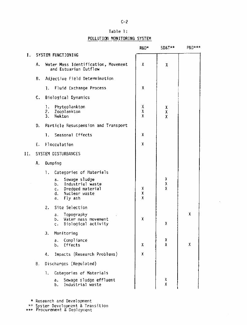
The Pollution Working Group has prepared a, framework thatillustrates categories of pollution disturbances that can affect theocean system, has indicated the applicability of acoustic techniques toeach of these and has identified recannendations aimed at improvingNOAA's capability in these areas. See liable 1, p. C-2.!
NOAA Responsibilities in Ocean Pollution
'Ihe basic 1%AA responsibilities in monitoring ocean pollution areexpressed in the following misting legislation: a! Shrine ProtectionResearch and Sanctuaries Act of 1973, b! Marine hhmmls Act, c! Fish-eries Conservation Act, d! Clean Water Act, e! National OceanPollution Research and Development and Monitoring Planning Act of 1978,and f! Coastal Zone legislation.
In the programs supporting this legislation, measurands includecurrents, particulate and chemical distributions, and temperature anddensity fields. Measurements of currents are required for dilution rateestimations and for flux measurements. Acoustic surveys providesynoptic measurements for concentration fields and currents. Oceanpollution surveys also require direct sampling as well as optical andacoustic remote sensing techniques. However, continued research anddevelopnent are required for determining the best way of making thesemeasurements with respect to volume of ocean covered in the shortesttime.
C-2
Table 1:
POLLUTION MONITORING SYSTEM
R8 D* SDST"* P8 D***
SYSTEM FUNCTIONING
A. Hater Mass Identification, Movementand Estuarian Outflow
B. Adjective Field Determination
1. Fluid Exchange Process
C. Biological Dynamics
1. Phytoplankton2. Zooplankton3. Nekton
D. Particle Resuspension and Transport
1. Seasonal Effects
E. Flocculation
II. SYSTEM DISTURBANCES
A. Dumping
1. Categories of Materials
a. Sewage sludgeb. Industrial waste
c. Dredged materiald. Nuclear waste
e. Fly ash
2. Site Selection
a. Topographyb. Water mass movementc. Biological activity
3. Monitoring
a. Complianceb. Effects
4. Impacts Research Problems!
8. Discharges Regulated!
1. Categories of Materials
a. Sewage sludge effluentb. Industrial waste
* Research and DevelopmentSystem Development 5 Transition
*+* Procurement 8 Deployment
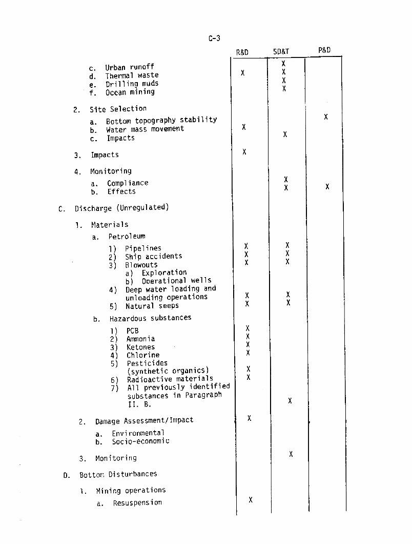
C-3
PSDSD5TR&D
Urban runoffThermal wasteDrilling mudsOcean mining
3. Impacts
4. Monitoring
a. Complianceb. Effects
C. Discharge Unregulated!
l. Materials
a. Petroleum
1! Pipelines2! Ship accidents3! Blowouts
a! Explorationb! Operational wells
4! Deep water loading andunloading operations
5! Natural seeps
b. Hazardous substances
1! PCB2! Ammonia3! Ketones4! Chlorine5! Pesticides
synthetic organics!6! Radioactive materials7! All previously identified
substances in ParagraphI I. B.
2. Damage Assessment/Impact
a. Envi ronmentalb. Socio-economic
3. Monitoring
D. Bottom Disturbances
l. Mining operations
a. Resuspension
2. Site Selection
a. Bottom topography stabilityb, Water mass movementc. Impacts
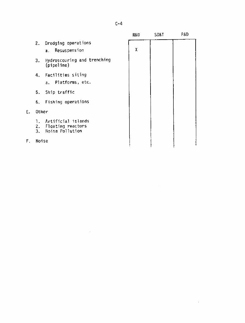
C-4
SD8T P8DR8D
2. Dredging operations
a. Resuspension
3. Hydroscouring and trenching pipeline!
4. Facilities siting
a. Pl atforms, etc.
5. Ship traffic
6. Fishing operations
E. Other
l. Artificial islands2. Floating reactors3. Noise Pollution
F. Noise
C-3 Present Uses of OARS Techniques
There are very few NOAA pollution monitoring programs currentlyusing OARS techniques. These are: the ACML acoustics program underJohn Proni, the National Ma.rine Fisheries research program under MikeMacauley, and the Woods Hole Oceanographic Institution program underMarshall Orr. This last program has been partially sponsored by NOAA-
Prime measurands in these three props include the backsca,tteredacoustic intensity field, concentration levels in space and time oftotal suspended materia,l, and various chenical canpounds and verticalprofiles of various oceanographic parameters such as tanperature,salinity, and current. The products required are a series of maps ofthe acoustic hackscattered intensity field and the chemica,lconcentration field for the purpose of obtaining the dilution rate ofthe material in question.
The following programs require the previous measurands and use OARStechniques to a minimal degree:
Outer Continental Shelf DevelopnentHazardous Material Spill ResponseResource MiningEnergy Utilization e.g., Ocean ihermal Energy Wnversion!Waste Disposal Marine Ecosystems Analysis Program!
C.4 Promising Uses of OARS Techniques
C.4.1 The following OARS techniques may not exist presently butcould be expected to support measurement programs:
1. Fixed projector and fixed receivers to measure flux inclosed channels, e.g., Hudson River.
2- Side scan or equivalent systans to provide 3dimensionalsensing.
3. Water current measurements utilizing the followingtechniques: doppler backscatter, correlationtechniques, horizontal acoustic propagation paths,bott~unted transducers, reciprocal tranaaission.
4. Measurement of biota layers and their behavior.5. Acoustic navigation within a survey area.6. BackscatteI for littoral transport measurements.
C.4.2 The following list presents several types of investigationswherein GARS techniques may augment existing approaches:
1- Moored projector and receivers to investigate anddevelop currents time series data in conjunction withexisting current meters and sampling procedures fluxrneasurernen ts ! .
2. Aids for direct sampling efforts.3. Current measurements, via expendable transducer.4. Backscatter and transmisscmeter studies.
C-6
Underwater navigation net in conjunction with othernavigation techniques within survey area.Volmmtric current measurements to provide calibrationchecks for HF radar.Meamremmt of surface oil slick thickness to complementEM mapping of an oil spill and also mapping ofsubsurface oil plena.
C.5 Goals for OARS lmplanentation
Research and Developnent: a! Determine generalquantitative limits for the acoustic estimate of theconcentration field distribution. b! Carry out aresearch program to determine the basic physica,l andparticulate properties of a. given oceanic region whichwill then govern the evolution of an acoustic currentmeter system.
System Developnent and Application: a.! Develop ashallow water acoustical current meter. b! Develop a3-dimensional scanning system for a, more completemapping of a pollution event. c! Develop an upwardlooking bott~unted, internally-recording acousticalsystem for both concentration field and current fieldmeasurements.
2 ~
Procurement and Deployment: a! Pla.t form acccemodatingsuite of personnel and instrmnentation required for teamapproach.
3.
C.5.2 Planning Elements
Facilities. Assuming that the general goal of the part4.5.1 above and/or Recarxnendation 4.7, item 1 below isimplemented, it follows that an acoustics engineeringlaboratory is required together with offices perhaps10! and a staging/storage area.
Personnel. It is estima.ted that 15 to 20 persons arerequired to adequately staff the re~nded acousticsgroup for 4.5.1 ~
Time. If a currently extant acoustics group at Miami ACML! is expanded to the pilot general acoustics groupdiscussed in 4.5.1, a two-year time frame untiloperation is reasonable. If a totally new group isformed, a four-year time frame is reasonable for start-up period!.
3.
Developnental and Operationa.l Financial Cost. An annualbudget of ~q750,000 to $1,000,000 in texms of PY 80dollars appears reasonable to achieve these goals.
C.5.1 Genera,l Goal. Set up an acoustic group which is responsiveto NOAA and other agency needs with the following programelements:

C-7
C.6 Policy and Problem Areas
Organization of OARS Effort. NOAA should establish an OARSresearch and developnent group under a principal acousticscientist. This group should be funded frcm the Office of MarinePollution Assesmmnt CMPA! with hardware support fromm the Officeof Ocean Engineering. 'This formulation of a. specific NOAA effortto use OARS techniques should not preclude individual agencies orlaboratories fran initiation and developnent of GARS pmgrams tosupport in-house activities using state-of-thwart technology.In a short-tern crisis situation, the R 8r. 0 group would bedirected by QMPA to respond cooperatively with other NOAAinvestigative effort.
C.6.1
Problem Areas. Scientific, technical, and administrativeproblem areas include:
C. 6.2
1. Continuity in funding and qualified staffing levelswithin the existing NOAA personnel framework.
2. Establishment of confidence limits on the concentration
levels within the acoustic field.
3. Rapidity with which an OARS survey of an event orprogram can be accomplished considering existing supportlevels.
4. Procurement of viable support for record cataloging,data management and reduction, and real time computerservices.
Conclusions and ReccmnendationsC.7
In order to overcome deficiencies it is recaanended that:
l. A panel be created within NOAA or an individual identified tocoordinate acoustical activity. This individual or panelshould report to high-level management, possibly to anAssociate Administrator.
2. A second OARS workshop be convened in two years.
It is concluded that the use of ocean acoustic remote sensing inpollution research and monitoring is increasing. The usefulness andimportance of OARS in studying oil spills, dredge material discharge,sewage sludge discharge, and industrial waste discharge is now firmlyestablished. NOAA should support acoustics research in this areabecause the requirements are extensive and the techniques must beimproved and quantified with respect to vol~ coverage, pollutant type,and diffusion and dispersal properties. The dcmmds placed on theacoustics group at AOML fa.r exceed its resources in personnel andfacilities.
C-8
3. N3AA support research efforts to establish confidence limits inorder to quantify acoustical estimates of a particulate field.
4. NOAA support research efforts to create a shallow water < 100 m! oceanic current measurement systan utilizing any orall of the following: i! doppler backscatter, ii!correlation and/or iii! reciprocal path techniques.
Working GroupPollution
Dr. John R. Proni
Atlantic Oceanographic and MeteorologicalLaboratories/NOAA
Asst. Qmirman: Capt. R. Lawrence SwansonOffice of Marine Pollution Assessment/NOAA
Dr. Fred H. Fisher
Marine Physical LaboratoryScripps Institution of Oceanography
Dr. !hvid L. GardnerEhcific Marine Environmental Laboratory/NQAA
Dr. Reginald HillWave Propagation Laboratory/NOAA
Dr. Michael MacaulayNorthwest Fisheries Center/NOAA
Dr. Marshall H. Orr
Woods Hole Oceanographic Institution
Dr. Arthur P. PinsakGreat Lakes Environmental Research Laboratories/NQAA
Mr. William E. Woodward
Of fice of Ocean Engineering/NOAA
~Member, Steering Comnittee, +Speaker
CCRC SERVICES WCBKIM' GHOUP REHRTD.O
D.1
D.2
Introduction
High Priority MissionsD.2.1 Fishing Qmtruction QuartsD.2. 2 Clear Channel DeterminationsD.2.3 Bathymetric hhppingD.2.4 Current Surveys � Time SeriesD.2. 5 Real Time ~nt Information for Safe Harbor/Channel NavigationPossible Future Missions
D.3.1 Sea Floor GeodesyD.3.2 Periodic Synoptic Tempera.ture vs. Depth MeamnementsD.3.3 Site Specific Surveys/Sea FloorPolicy IssuesConclusions 8r. Recamnendations
D.3
D.4
D.5
D.l !ntroduction
The National Ocean Survey NOS! and the National Ehta Buoy Office NDBO! manage ocean platforms and instrments to collect oceanographicdata needed: a! for the production of oceanographic informtionproducts, b! as input for special civil projects in the ocean, c! tosupport their scientific researches, and d! as indicators of pollution,storm signals, etc. Ocean Services, in the context of this workinggroup effort, is defined as the collection of at-sea data in support ofsuch needs as those stated above.
The group reccgnized that there are ocean service needs for whichit is not obvious that the application of OARS techniques would bebeneficial, and there are ocean service needs that are good candidatesfor OARS techniques. Indeed, active sonar, an OARS technique, is usedfor doing practically all of the depth sounding for nautical charts.Currently, all operational systems in NOH are single beam systems butanalysis and experiments are being conducted with dual frequency, dualbeam systems and single frequency multibeam systems which will enhancethe efficiency of nautical chart production.
1 ~ Fishing Obstruction Charts2. Clear Channel Determination
3. Bathymetric Maps4. Current Surveys � Time Series5. Real Time Current Information � Harbor/Channels6. Sea. Floor Geodesy
Other service missions which are necessary or may becane necessaryin the near future and which appear to represent sensible application ofOARS techniques are:
7. Periodic, Synoptic Temperature vs. Depth8. Site Specific Surveys on the Sea Floor
Missions one through five above were deemed by the Working Group tohave the highest priority based on iranediacy and needs of the mission.The ranaining three represent potential missions for the future withrequirements as yet not well defined.
In keeping with the broad objectives of the workshop, the WorkingGroup established the following objectives for its deliberations:
Select OAHS techniques, applicable to oceanographic servicemissions, as candidates for inclusion in the OARS program.Provide rationale for selection of above candidates.For each of the above candidate techniques, reccmnend OARSprogram goals for the nest 5 years!.Estimate resource requirenents to achieve the above OARSp~gx~ goals.Address M!AA policy issues that could influence theeffectiveness of a NOAA/OARS program.
2 ~3.
4.
D.2 High Priority Missions
D.2.1 Fishing Obstruction Charts
1. Brief Description of Need
As a result of recent legislation, NOS is under mandate toproduce fishing obstruction charts. Both natural and man~eobstructions must be charted by a date to be specified. Aftercharts are produced, the government will be liable for claims bythe comnercial fishing industry for damage to nets and otherequipnent caused by obstructions not charted. The governmentwill also be liable for claims of consequential damages lostrevenues! as a result of damage to equipnent. New surveys andverification of damages due to uncharted obstnmtion will berequired. The area coverage over 800 thousand square nauticalmiles! is too great to survey before chart production. Mepresent approach is to produce charts initially using allcurrently available information in order to meet publicationrequirements. It is presently contemplated that areas of majorconcern will be surveyed under contract. 'Ihe wire drag techniquewould be very slow in areas of numerous obstructions.Verification of claims and the continuation of surveying will berequired in as cost � effective an approach as possible. Thestrategy for survey and concept development should be consideredin conjunction with the requirements for clear channel andbathymetric surveys discussed elsewhere in this report! becauseof important similarities in requirenents.
Sections D.2 and D.3 deal with items one through four above andSection D.4 deals with NOAA policy issues � item five. Section D.5 is a.statement of conclusions and reccemendations.
2. Requiranents
a . We location and least depth of all obstructions orareas of nrinerous obstructions will probably be charted at a1:80,000 scale.
b. Objects such as a pipe or wellhead, 1/3 meter diameter,projecting 2/3 meter fran bottcrn, must be located. Underwaterpiling, rock outcrops, and other natural features which arelikely obstructions must be indicated.
c. Depth of concern will be fran 10 meters and 200 meters.
d. The effective coverage rate which appears feasible is 2square nautical miles/hour with a detection probability of 8'.
e. False/real target ratio false target alarm rate! may bea significant cost factor and as such should be considered in itssystem design.
f. Positional accuracy will be i+ran C or better.
It is not intended that the entire area. u~s of 800,000square nautical miles will be systematically surveyed. Welikely strategy will consider systematic survey over selectedareas and survey to verify or follow up on reported obstructionsand claims. Hence an effective survey rate of 2 square nauticalmiles per hour for each of several survey platforms may beadequate. A detection probability of 80%, or perhaps 90%, isalso considered adequate because a failure to detect a particularobstruction does not necessarily result in a catastrophic loss.'The cost of the attempt. to approach 100% detection probability islikely to outweigh the benefits.
3. Concept
High frequency, high resolution sonars could be developed tomeet this requirement. The mapping requiranents are well mtchedto the resolution dimensions which can be achieved with side-looking sonars SLS! and scanning mine-hunting sonars. The ~systems are considerably simpler and inherently less costly thanthe horizontal scanning sonars and thus sean better adapted touse for this function. However, any developnent program shouldinclude a review of current mine-hunting sonars and sonardevelopnent programs in the U.S., U.K., and France which have themost significant and accessible activities in this field.
SLS systems, configured to opera.te in a towed mode frcrn anyof a number of NOAA or chartered ships could start by surveying,with Loran C or one of the shorter range systems e.g., Raydistnavigation! in primary fishing a,reas with full coverage; followedby thin coverage in areas with steep or irregular topographywhich probably have such extensive roughness as to be categorizedin terms of large continuous areas of obstacles. We goa.l of two
square miles per hour can be achieved with a properly developedmulti-lane multibeam! system. The principal operational problemto be faced by an idealized systan is the existence of falsetargets. Since the principal ones will be biological they willpresent the greatest difficulty in the areas of most fishingactivity. This problem will be addressed in the section titledRequiranents for each mission.
4. Status
Operational caanercially available SLS systems can detecttargets of the specified minienrn size; however, they lack therequired area coverage rate. Simple syytans with half y meterlateral resolution can cover only 750 m /st* or 2.7 km /hr,substantially short of the target of 6.8 km /hr. A multibeamsys~, of which one prototype has been built, could achievethis sweep rate using 3 beams. 'Ihis would be primarily adevelopnent problem since the basic signal processing approachand environmmtal parameters are reasonably well known. Yawcanpensation would be required. It would also be desirable toincorporate a doppler measuremmt capability for clearly definedtargets to allow discrimination against sane biologicalassemblages to reduce the nunber of false objects.
5. Program Goals
Analysis and concept formula,tion FY 1981
Design developnent and fabrication FY 1983
FY 1982-1983
FY 1984
Technique developnent
Operational
Cost from FY 1981 to FY 1983 82 million
It remmrmnded that a program be developed with the goalsindicated above. It is estimated that $2 million would berequired through technique developnent by the end of fiscal year1983. This would include both the cost of in-house effort andcontract ef fort.
D.2.2 Clear Channel Determinations
l. Brief Description of Need
*See Ocean Acoustic Ranote Sensing of the Sea Floor," FredN. Spiess, GARS Paper ¹11.
'the clearance and certification of clear navigation charnelsis presently done by wire drag operation. The increase in vesseldrafts along with the designation of traffic lanes in previouslyuncertified areas has placed increased emphasis on more cost-effective techniques for clearing channels. Two types of areas
The deep water area is presently being addressed with thedevelopnent of the bathymetric swath sonar system BS ! whichwill provide 1 N% coverage of the bottcm and will locate anddetermine least-depth on all topographic features which projectup to the operating depth of deep draft vessels in areas deeperthan such features.
The shallow water clear channel areas of the Gulf, Atlanticcoastal areas and harbors, presently being acccxnplished by wiredrag, represent a more difficult detection problem than thatdiscussed above. 'Ibis is because both the natural and man~deobstructions of significance can reach to only two or three feetabove the bottcm and yet be of concern. The BOS'N BS would notbe adequate for such determination.
2. Requirements
Shallow water
Obstacle size
20~ meters
2/3 m high, 1/3 m diameter
probability of obstacledetection 99%
Channel width 200 m to 5 Km
Effective area coverage 3-5 sq.km/hr � sq nm/hr!
Positional accuracy 3-10 meters
False/real target ratio is a significant relationshipsince all targets are investigated.
The above requiranents are scxnewhat similar to therequirements for the fishing obstruction charting missions. Onemajor exception is the more stringent probability of detectionnecessary for clear channel work. It is thought that a program ofdeveloIxnent or application engineering for a side-looking sonarfor the fishing obstruction charting mission could probably becanbined with one for this mission. 'Ihis should be addressed i.nsubsequent OARS program planning. OAHS technology effort for thebathymetric mapping mission might possibly also be integratedinto a. program for the above two missions. .he goals andbudgetary estimate on a stand-alone basis! for developing asystom for the clear channe1 mission are given below;
are important' .the deep water of the West Coast and Ala,ska, where' large bott' features in uncharted areas may exist; and theshallow water of the East Cbast, Gulf off-shore, and ha.rborareas, where small objects may exist, e.g., pipes, pilings, andwrecks, as well as rocks and sand waves.
3. Concept
Existing available swath echo sounding systans seemappropriate for locating pinnacles and the like in deeper waterharbor approaches. In shallower water a side-looking sonar ofthe type implied under the Fishing Obstacle heading would provideappropriate coverage for location of discrete objects. Thehigher detection probability would be achieved by multiple sweep~of the area and by incorporating additional preformed beams.Given the greater importance of shallow water < 50 m! this mightwell be a hull-taunted system.
4. Status
'Ihe corresponding section under fishing obstacles covers thesituation with regard to detection of discrete objects. Withregard to the SLS interferaneter-type swath mpping sonar, onesuch has been built, with quite different requirements, by V. C.Anderson of the Marine Wysical Laboratory MPL, Scripps! and amore nearly equivalent one is under developnent for the MPL DeepTow by Spiess+. Neither of these, however, has had to cope withthe close presence of the sea surface. The problans associatedwith the discrete object detection are similar to those presentedunder fishing obstruction charting. In the case of theinterferometer adjunct, the principal developnent would be thedesign of a transducer and associated signal processing toeliminate the interfering effects of the sea surface. Beyondthat the primary concerns would be in selection of appropriatesystem parameters and construction of a prototype systaa.Consideration would have to be given to data storage andprocessing since the data rates would approach 100 soundings persecond
5. Program Goals
Analysis and concept formulation FY' 1981
Design, developnent, and tabulation FY 1983
FY 1982-FY 1983
FY 1984
Technique development
Operationa,l system acquisitionand use
Cost $2 mil lion through techniques developnent
Full bathymetric coverage is required in shallow water,where the swath width of existing downlooking multi-beam soundershas smal 1 lateral dimensions. An interferaneter-type SLSadjunct~ can, in principle, provide a much larger sweep widthand is particularly well notched to the low-relief circmastancesinvolved. This could give at least a 400 m swath in 30 m ofwater over a nearly horizontal sea floor.
D.2. 3 Bathymetric hhpping
l. Brief Description of Need
a.. Deep Ocean to 200 nmi
b. Pacific shallow water 40 m � 600 m depth
c. Atlantic and Gulf shallow water 10 m to 200 m depth
d. Coastal shorelines 0-10 meters depth
The Deep Ocean areas are being addressed with thedevelopnent of the Sea Beam swath system. The Pacific shallowwater system which utilized the BQS'N sensor is also underdevelopnent hand is expected to be operational in about a year.It is the BS noted earlier. It is generally slow and hazardousto do bathymetric surveys in the coastal shoreline areas havingdepths under ten meters fran boats using acoustic techniques.This is one of the reasons for the present effort in N08 todevelop an airborne laser technique.
The largest area of concern for which a system does notexist but is of major concern is in Ehst Coast and Wlf shallowwater of 10-200 meters depth. This is also the most extensiveshallow water area requiring fisheries obstruction charts. Thesurvey platform therefore may possibly be the same.
2. Requirements
The shallow water East/Gulf Coast requirements are:
Surveying by anall boats based on ships or shore�based mall boat field parties. Boats aretypically 25-35 feet long with 30 kn capability.
a ~
Water depth: 10 to 200 meters.
Accuracy: + .3 m + .005 depth!� sigma! ~
b.
Co
Swath angle; up to 160 to provide depth andreconnaissance data so as to minimize number ofvessel track lines.
d.
'Ihe present N38 bathymetric mapping program utilizesexisting data collected for nautical charting. Manual processesare employed to analyze and dra.w the detailed contours for thesema,ps which are used for base maps for various endeavors includingthose of the Bureau of Land Management BM!. Requests for asignificant armunt of ship time and bathymetric surveys ha.ve beenreceived during the '80s out to the 2C6-mile limit along theAlaska and Pacific coasts. 'Ihere are four operational areas ofconcern;
e. Survey of freya flat to slightly undulatingbottcms to very rough, jagged rock~utcroppingand coral bottoms.
f. Resolution on bottoxn at a depth of 100 meterswill be 10 meters;
g. Wsitional accuracy will be 3 to 10 meters.
3. Goncept
Multiple-beam swath techniques have been used forbathymetric surveying by NQAA and the Navy. An interfercmetricconcept, used in airborne side-sean radars, appears to offerenhanced resolution and efficiency relative to the multi-beamswath technique.
4. Status
Basically, the technique is well understood and no unusualtechnological problems are foreseen in developing it for theabove requirements.
It is recomnended that a plan be prepared to achieve thegoals given below.
5. Goals
The analysis and conceptual formulation and exploratorydevelopnent should be accanplished in an initial phase since thistechnique appears to have a degree of developnent risk. Thisphase could logically be integrated with the clear channel andfisheries obstruction system concept developnent. 'Ihe programmight appear as follows:
Phase I:
Analysis and concept formulationExploration develognent
FY 1981
FY 1982
Phase II:
FY 1983-FY 1984
FY 1984-FY 1985
FY 1986
Design developnent and fabricationTechnique developnentOperational use
Basically two identical horizontal arrays are installed, oneabove the other, on each side of a vessel. The physicalseparation of the two interconnected horizontal arrays in thevertical plane gives rise to an interference pattern onreception. The greater the separation, the greater the number ofinterference lobes and the greater the resolution in the verticalplane. The problem is reduced on transmit by using only one ofthe two arrays.
Budgetary estimates including in � house effort!
First phaseSecond phase
$1.5 M$4.0 M
FY 1981-FY 1982FY 1983-FY 1985
D.2.4 Current Surveys � Time Series
1. Brief Description of Needs
A self-contained remote-sensing, bottom-rmunted,multibeam-doppler sonar current measuring technique presentlyunder develoIment appears to provide the solution to the problemin that the unit will be located at the bottan, out of theturbulent surface regime. Survivability is an additionaladvantage realized, since the currents measuring system islocated well under the keels of passing vessels.
2. Requiranents
a. Vertical profiling of currents to 200 m depths
b. Speed Accuracy/Resolution of 0.1 kn/0.2 kn
c. Directional Accuracy/Resolution of 3 -5 /50 0 0
d. Unattended operation for two months
e. Battery operation
f. Current Speed Range to 10 kn
3. Concept
Basically, the remote sensing concept envisioned for thisapplication is a bottom-mountex9 three or four beam dopplertechnique. In principle, the technique is similar to the bottantracking doppler navigation equipment presently installed aboardvessels. Conceptually, the technique proposed is an invertedbott~unted ship's navigational system using time-gating tomeasure doppler returns from predesignated layers in the water
The National Ocean Survey provides tables of currents forthe estuaries and near shore areas surrounding the United States.This information is used for vessel navigation safety and bythose conducting operational and scientific programs. At presentthe measuremmts of currents are made in situ by securing currentmeters to a mooring line extending fran a surface buoy to ananchor. Unfortunately, the ~tion of the buoy is coupled intothe current meter as noise, thus degrading the measurement andits accuracy. Analyses and tests conducted by WHOI, NOS and NDBOconfirm this problem. Typically currents are measured in depthsranging from 10 m to 200 m. The number of current meters securedto the mooring varies as the depth, with up to three meters usedat the greater depths.

colm'. Since the doppler signals are returned fran scatterersin the water colm', the signa,l-to-noise ratio is dependent uponall scatterers including biota. However, noise generated by thedynamics at the surface is not coupled into the signal.
4. Status
To date, the concept has been demcestrated throughexperiments in controlled and open environm..nts using a singlebeam system as well as with a four beam system munted on a,vessel.
'Ihe next phase, in the final process of developnent requiresthe developnent of a signal estimator. The signal estimator willbe developed fran results of experiments using a three or fourbeam system. Several experimental systans are available and,with minianm modification, can be used for conducting experimentsin several typical estuaries.
Following the developnent of the signal estimators,specifications will be ccmpleted for the procurenent of aprototype system for test and evaluation.
Following are estimated schedules and costs for campletionof the work.
5. Program Goals
FY 1981-FY 1982Develop Engineering Model
Experiments and Demonstrations FY 1982
FY 1983
FY 1981-FY 1982
Operational
Cbst of $400 K
1. Brief Description of Needs
Studies conducted by the Coast Qua,rd and the New York PortAuthority have shawm the desirability of providing real timecurrents, water levels and winds in harbors and ship navigationchannels. Winds and water levels for the harbor and channelscan be inferred from measurements made along the shoreline,whereas currents are desired at strategic locations.Unfortunately, moored current measuring systans are vulnerable toship traffic.
A remote-sensing, bottcermounted, multibeam-doppler sonarcurrent measuring technique presently under developnent, appearsto provide a solution to the problem.
D.2.5 Real-Time Currents Information for Safe Harbor/Channel Navigation
2. Requirements
Although specific performance requirements have not as yetbeen established for the measurement of these currents,preliminary discussions seem to focus on the following:
a. Vertical profiling of currents Top 40'
b. Provide currents to four depths 10', 20', 30', 40'
c. Speed Accuracy/Resolution
d. Directional Accuracy/Resolution
e. Unattended operation for one year
O. Ikn/0.2 kn
30 50/50
f. Ebwer and signal cable trenched to shore
g. Current/Speed range
h. Deployment depths
0-5 kn
<30m
3 ~ Concept
Basically, the remote sensing concept envisioned for thisapplication is a bottom!unted t~ or four beam dopplertechnique. In principle, the technique is similar to the bottantracking doppler navigation equipnent presently installed aboardvessels. Conceptually, the technique proposed is an invertedbot5~eunted ship navigational syst~ using time-gating tomeasure doppler returns frcm predesignated layers in the watercolann. Since the doppler signals are returned fran scatterersin the water coleman, the signal-to-noise ratio is dependent uponall scatterers including mobile biota- However, noise generatedby the surface dynamics is not coupled into the signal.
4. Status
To date, the concept has been danonstrated throughexperiments in controlled and open environments with a singlebeam system.
Following the development of the signal estimators,specifications will be completed for the procurement of aprototype system for test and evaluation.
'Ibe next phase, in the final process of developnent requiresthe determination of a signal estimator. The signal estimatorwill be developed fram results of experiments using a three orfour beam system. Several experimental systole are available andwith mininnm modification can be used for conducting experimentsin several typical estuaries.
D-12
Following are estimated schedules and costs for completionof the work.
5. Program Goals
Develop Kngineering Model FY 1981
Experiments and DHnonstrations FY 1982
Specifications, procurement and FY 1983mnOperati.on
Cost of $400 K FY 1981-FY 1982
As can be seen in the previous section on tine seriescurrent surveys for other applications, there is significantsijnilarity in technical perfonnance requirenw.nts. It will beseen that same of the effort in the above program will,therefore, be directly applicable to both sets of requireamnts.
D. 3 Possible Future Missions
D.3.1 Sea Floor Geodesy
An area for systan improvement appears in the geodetic andrelated geological! context in which one desires to docunentgradual changes of sea floor geometry. 'this could be in coastalor slope areas where large-scale creeping and slumping any occurand in the vicinity of ocean spreading centers and transformfaults. These can be docunented using networks of transpondersand appropriate trilateration approaches. Transponder designshave been formulated and bench tested which can control theresponse delay times to within a microsecond or better ifnecessary, thus eliminating this problem frcm contributing touncertainty. Similarly it seems feasible to build sound velocitymeters for use in survey a@as to give reliable values of speedof sound to one Part in 10 about one an/sec!. Vith these twocapabilities, it becanes possible to resolve motions of a few cmover distances as great as a few km, given careful design of theoverall experiment and related canputational methods. 'Ibis wouldmake it feasible to measure spreading rates directly atintermediate- and fast-spreading centers. In such situations,the full rate is fran 5 to 20 cm per year and the region overwhich this builds up ranges fram 2 to 10 km. In this contextthen, acoustic transponder techniques can beche in thanselvesacoustic remote sensing instruaents, providing measurenM nt ofgeodynamic effects as they occur at the sea floor. Thistechnique has the possibility of being extended to themme~ment of accumulated earth stress and thus L~ming a toolfor earthquake prediction.
Other uses for such techniques are resource assessment,national and state geographic boundaries and subdivision of thebottom for ownership, zoning and resource exploitation purposes.
The Ocean Services Working Group considered this potentialacoustic technique but was uncertain whether sea floor geodesy isa NQAAmssigned mission at present. Iherefore, it is reccnmendedthat this concept be brought to the attention of the NationalGeodetic Survey, which has a better understanding of NQAA'spresent or prospective role in sea floor geodesy. Pendingresolution. of this issue, the technique described above should bereconsidered for possible inclusion in a MAA/OARS program.
D.3.2 Periodic Synoptic Temperature vs. Depth Meamxrements
Temperature variations and the flow of heat in ocean surfaceand subsurface currents may play a major role in the air-seainteractionland, thus, in climatology. Monin, Kamenkovich andKort �977! ramark that the temperature field is the mostimportant of the oceanologica,l field studies in fisheries-relatedoceanology. Despite the success of the echosonde in observinggeophysical turbulence, winds and ocean currents, no practicalextension of acoustic ranote sensing to measurarent oftemperatures and temperature profiles has appeared feasible untilnow. Other nonacoustic remote sensing methods have limitationsin geometry or resolution. The importance of temperatureobservations in geophysics thus forces the continued use ofcostly and intermittent devices, such as radiosondes in theatmosphere or XB7's in the ocean. Sane scientists would preferto obtain a three&imensional synoptic ocean temperature mapwhich the XBT is not ideally suited to provide.
Such ocean temperature information is vital to theprediction of sonar system perfoxmance on a daily or morefrequent basis. It is, therefore, of great interest to the Navyas well as the fishery biologist and climatologist.
3vo acoustic approaches for obtaining temperature versusdepth measurements were considered at this workshop by the OceanServices Working Group. Since time was limited, other acousticmethods were not explored, but may exist.
One system suggested by Watts at the OARS workshop plenary2
session was a bottom-mounted inverted echo sounder that measures
1Variability of the Oceans, John J. Lumley, ed., 1977, John
Wiley k, Sons.
2OARS Pa.per ¹13, this volume.
the round-trip time fran hottan to surface and hack. Sincetemperature is the most important variable in the speed of sound,temperature changes frcm known profiles can be inferred. Sincemost of the temperature changes occur in the mixed layer, andthis layer is of the most interest to the potential users of theinformation, experimentation with the technique might revealmeans of extracting useful data about that portion of the watercolm'. At best, ~er, one would have only an averagetemperature over that portion. 'Ihe integrated sound velocity therefore temperature! over the entire vertical depth zILy be ofinterest to some users. The effects of salinity and particulatematter may limit the technique scmewhat. Further, bubbles willeffect mund speed considerably and may present analysislimitations.
Brown suggested an approach for obtaining a temperature1
versus depth profile, the preferred data set. In 1976, he andhis associates conducted an experiment that canbined thescattering of sound with the formation of thr~imensionalfringes in space by constructive interference of properly spacedmurces as in a Young's interferaneter!. Recently Brim �979!described an acoustic remote sensing thermaneter, for which hereclaimed an old designation, echaneter, that canbines theprinciples of the above experiment with techniques that includecurve fitting of pulse envelopes and measuranent of the meanphase within pulses. Preliminary results indicate that theechaneter may provide temperature nmas~ments to within a fewtenths of a degree Kelvin in the atmo~ere and a few hundredthsof a degree Kelvin in the ocean, out to ranges of about 500meters. The spatial resolution is about 10 m in the atmosphere,and about 1 m in the ocean.
'Ihis system euuld he ship, buoy or possibly bott~unted.
The Ocean Services Working Group considered these approachesand concluded that while NOAA does have research missions whichneed temperature vs. depth infoxma.tion, remote acoustictechniques for such profiling are yet to be demonstrated.Develognent or applications engineering for ocean servicesapplications should not yet be programrmd. Present explanatoryefforts should be continued and encouraged.
D.3.3 Site Specific Surveys/Sea Floor
A number of special task areas in which acoustic ranotesensing could play a significant role were identified. 'Jhesetask areas are discussed as a group because of several caanonfactors:
1 OARS Paper 015, this vol~.
o Each task requires detailed information about a specificlocation on or below the sea floor.
o NOAA's role or responsibility for performing the task isnot clearly defined.
o Technology, acoustic or other, exists to perform the task,but requiranents for improvement of existing technology ordevelopnent of new technology are not known.
'Ihe specific ~ identified include: sea floor resourceassessment, surveys of potential nuclear waste disposal sites,surveys of potential ocean thermal energy conversion OTIC!sites, assessment of the environmental effects of marine mining,and determination of the physical structure of the subbottcm-1he primary requirement for each of these task areas is detailedbott' mapping~ requirement that has been and can be met byacoustic remote sensing, as well as by other means e.g.,optical!. Most of the task areas also have related requirments,such as the need for precise current information, that can be metby acoustical techniques. Each of these task areas is discussedin more detail below; however, the discussion is limited togeneral cccments and recarmendations because NOAA'sresponsibilities are not well defined.
Resource Assessments Sea Floor! � The primary sea floorresources considered are mineral resources e.g., manganesenodules, sand, gravel!. NOAA responsibilities for detailed sea, Ifloor resource assessments may be inferred frcxn current missionstatements. However, these inferred responsibilities do notprovide sufficient justification for initiation of a, specificacoustic program. pending congressional legislation will assignresponsibilities and authorizations for marine mining activities,and it is expected that NOAA will have an expanded role in thisarea. For this reason, further evaluation of the application ofacoustic remote sensing to marine mineral resource assessment isrecamnended. This evaluation should be performed with NOAA'sMarine Minerals Division.
Nuclear Waste Disposal Site Surveys � The disposal ofnuclear waste in the seabed is an option under consideration bythe Department of Energy DOE!. DOE has suggested closercooperation between DOE and NOAA concerning current and futureresearch and development activities in this area.. DOE has aprimary requiranent for detailed mapping of the sea floor atpotential nuclear waste disposal sites water depth must begreater than 4,000 meters!. Acoustic technology for such detailedmapping exists but the number of available systans for performingthis task is limited because of the depth requiranent. NOAA'sresponsibilities for providing detailed bottom mapping at thesepotential disposal sites is unclear. Senior management levelDOE-NOAA discussions are being scheduled to address thesequestions, and internal NOAA discussions to eva.luate alternativeNDAA roles are in progress.
Acoustic remote sensing techniques can contributesignificantly to the study of potential nuclear waste disposalsites but specific NOAA programs cannot be designed or initiateduntil NQAA's role is clarified.
VfRC Site Surveys � Surveys of potential OPEC sites includenot only detailed bott' mapping, but extensive current andtetnperature mapping and determination of biological activity aswell. These surveys, which could be aided by acoustical remotesensing, are required to determine the potentia,l environmentalimpact of OPEC facilities and are currently the responsibility ofDOE. Pending congressional legislation, however, would assignsane of the responsibilii.les to NOAA. NOAA's role, with orwithout the legislative mandate, is presently under discussion bysenior NOAA management. Until resolution of these policy issues,no specific acoustic rem>te sensing programs can be recommendedwith respect to these missions.
Environmental Impacts of Marine Mining � Although the finalobjective of environmental impact surveys is sanewhat differentfran "resource assessmen~" surveys, the same or similaracoustical techniques could be applied. In this particular case,because the subject is environmental itnpacts of marine mining,cannents concerning NOAA's responsibilities and specific programrecottmendations are the,~ as for "Resource Assessment," above.
Subbottan Physical Structure � Acoustic techniques exist fordetermination of the subbottom physical structure; however, thequantity and quality of acoustical measuranents are not adequatefor scientific or operational e.g., siting of structures!purposes. Senior NOAA management is currently discusssing NOAA'sfuture role in this task area. Specific technology improvenentor technology develognent programs cannot be reccamended untilNOAA roles are defined.
It is recmrnc.ndea that NOAA's role with respect to the abovemissions be reviewed in about six months to formulate appropriateprogratn goals vis � a � vis OARS techniques for inclusion in a, NOAAOARS program.
D.4 Policy Issues
'Ihe Working Group recognized severa.l policy issues which should beaddressed to enhance the implementation of workshop reconznendations.Ihese policy issues fall into three broad categories: intra-agencyrelationships and cmmunications; interagency relationships andcottnnmications; and NOAA "corporate"-level involvanent in resourcesallocation for technology research and development.
1. Intra � Agency Relationships and Gmrntnications
Acoustic remote sensing cross � cuts a,ll of NOAA, in terms ofre~rch in acoustic wave propagation in the sea, developnent of
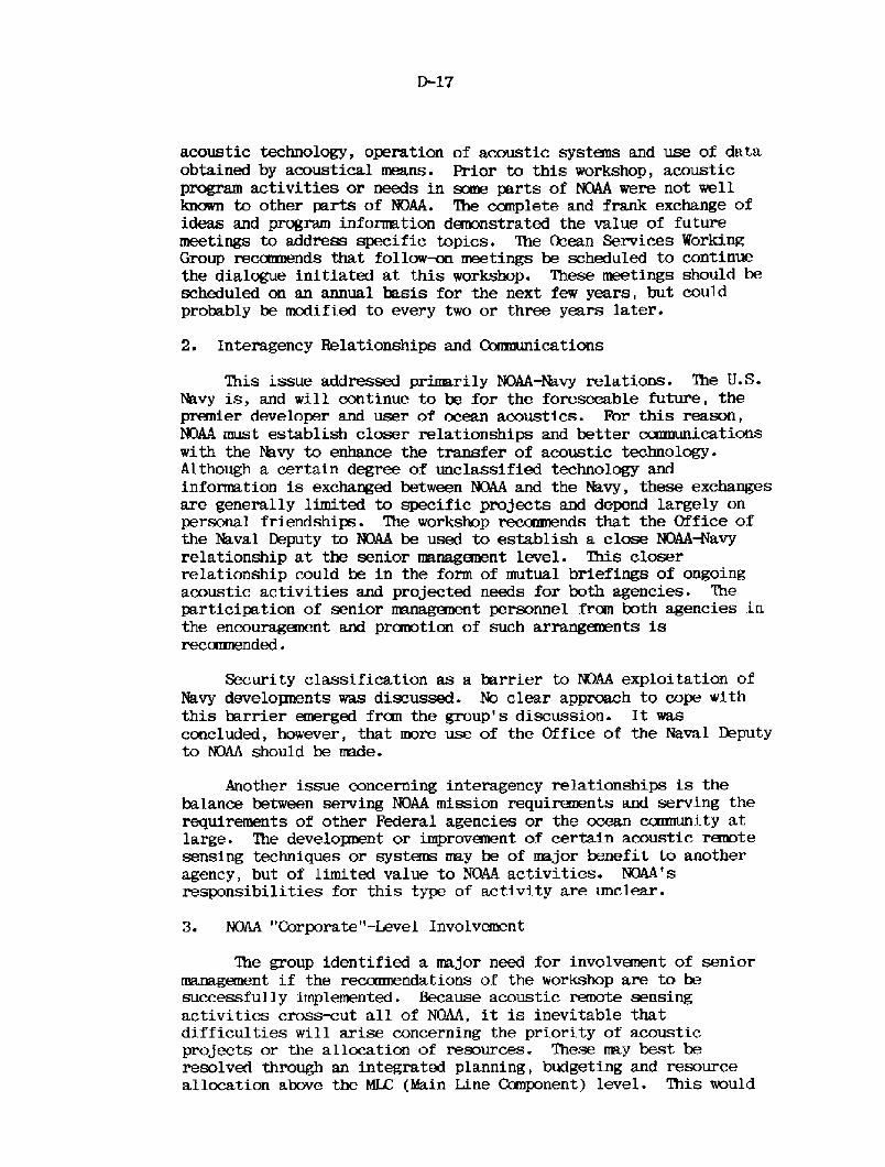
acoustic technology, operation of acoustic systans and use of dataobtained by acoustical means. Prior to this workshop, acousticprogram activities or needs in some parts of NQAA were not wellknown to other parts of NOAA. The complete and frank exchange ofideas and program information dmunstrated the value of futuremeetings to address specific topics. 'Ihe Ocean Services WorkingGroup reccxrrnends that follow~ meetings be scheduled to continuethe dialogue initiated at this workshop. These meetings should bescheduled on an annual basis for the next few years, but couldprobably be modified to every two or three years later.
2. Interagency Relationships and Goamunications
This issue addressed prirrarily NOAA-Navy relations. '?he U.S-Navy is, and will continue to be for the foreseeable future, thepremier developer and user of ocean acoustics. For this reason,NQAA must establish closer relationships and better ccxrmunicationswith the Navy to enhance the transfer of acoustic technology.Although a certain degree of unclassified technology andinformation is exchanged between NOAA and the Navy, these exchangesare generally limited to specific projects and depend largely onpersonal friendships. The workshop recamnends that the Office ofthe Naval Ehputy to NOAA be used to establish a close NQAAWavyrelationship at the senior management level. This closerrelationship could be in the form of mutual briefings of ongoingacoustic activities and projected needs for both agencies. Theparticipation of senior management personnel from both agencies inthe encouraganent and prcmotion of such arranganents isreconxnended.
Security classification as a barrier to NOAA exploitation ofNavy developnents was discussed. No clear approach to cope withthis barrier emerged frccn the group's discussion. It wasconcluded, however, that more use of the Office of the Naval Deputyto NOAA should be made.
Another issue concerning interagency relationships is thebalance between serving NOAA mission requirements and serving therequirements of other Federal agencies or the ocean ccmnunity atlarge. The development or improvement of certain acoustic ranotesensing techniques or systems may be of major benefit to anotheragency, but of limited value to NOAA activities. NQAA'sresponsibilities for this type of activity are unclear.
3. NOAA "Corporate"-Level Involvement
'Ihe group identified a major need for involvanent of seniormanagement if the reccxnnendations of the workshop are to besuccessfully implemented. Because acoustic remote sensingactivities crosscut all of NOAA, it is inevitable thatdifficulties will arise concerning the priority of acousticprojects or the allocation of resources. These may best beresolved through an integrated planning, budgeting and resourceallocation above the MLC Main Line Component! level. 'Ibis would

require that an official above the KC level, with broad scientificand technical background, but without a, parochial view toward theinterests of any S'IL, be intimately involved in the resourceallocation process. Perhaps the appropriate place for thisfunction is the N3AA Science and Services Kblicy Group.
In addition, it is felt that, as a matter of policy, a.percentage of the NOAA budget be designated for technology researchand developnent subject to the above allocation process to achievebalanced technology progmuns responsive to NQAA's ocean servicesand scientific missions.
Based cn econanic analyses and results of technical work conductedto date by industry and NOS, it is recamended that the acoustic remotesensing development program for Ocean Services be completed as discussedin Section D.2 abave.
%he developneat of techniques required to provide the high-resolution sonars in support of the hydrographic missions fishingobstruction detection, clear channel determination and bathymetricsurveys! should be funded. United States and foreign technology must beaddressed to assure use of prior work. It was also agreed that econanicand alternative concept tradeoff analyses must be conducted.
Many of the techniques applicable to the hydrographic mission areborrowed fran airborne sidelook radar developnents and are beingextended to meet ocean acoustic requiranents. It appears that, ~ ondiscussions of hydrographic requirements and possible techniques formeeting these needs, no fundamental physical limitations are foreseen.
Working GroupOcean Services
Dr. Stanley Al perOffice of Marine Technology/NOAA
Asst. Chairman: Mr. Maurice K. RingenbachEngineering Deve lopnent Laboratory/NOAA
Mr. William 0. Rainnie, Jr.NOAA Da,ta Buoy Office/NQAA
Mr. Mn A. AtkociusNava,l Oceanographic Of f ice
Cdr. Sam SigmundOffice of Policy and Planning/NOAA
Mr. Leo S. CraigOffice of Sea Grant/NOAA
Capt. Wayne L. MobleyNa.tional Ocean Survey/NOAA
+Speaker
D.5 Conclusions and Recaranendations
+ Dr. Fred N. SpiessMarine Physical laboratoryScripps Institution of Oceanography