Embed Size (px)
Citation preview
Highway 50C o r r i d o r S y S t e m m a n a g e m e n t P l a n
Working Paper 1Corridor Definition

Working Paper 1Corridor Definition
September 2008
interstate 80
®
®
highway 50 corridor system management plan

HigHway 50 corridor system management plan [ � ]
table of contents
Chapter �: IntroduCtIon 3
1.1 Overview .....................................................................................................3
1.2 Background .................................................................................................6
1.3 Relationship to Other Plans ..........................................................................8
1.4 Stakeholder Participation .............................................................................8
1.5 CSMP Value to Stakeholders .........................................................................9
Chapter 2: CorrIdor defInItIon and desCrIptIon ��
2.1 Highway 50 Corridor Limits and Rationale ....................................................11
2.2 Criteria for including System Elements in the Highway 50 CSMP
Transportation Network ..............................................................................12
2.3 Highway 50 CSMP Transportation Network: State Highway System ................12
2.4 Highway 50 CSMP Transportation Network: Parallel and Connecting Roads ....12
2.5 Highway 50 CSMP Transportation Network: Transit and Ridesharing ..............13
2.6 Highway 50 CSMP Transportation Network: Bicycle Routes ...........................14
Chapter 3: programmed, planned, and ConCeptual projeCts 25
3.1 Programmed Projects .................................................................................25
3.2 Planned Projects ........................................................................................25
3.3 Conceptual Projects ...................................................................................25
lIst of fIgures
Figure 1.1. CSMP Corridors in District 3 ..................................................................4
Figure 1.2. Strategic growth Plan Strategy ...............................................................7
Figure 2.1. Highway 50 CSMP Transportation Network Map.....................................15
Figure 2.2. Highway 50 CSMP Transportation Network Map (Sacramento insert) ......16
Figure 2.3. Highway 50 CSMP Corridor Bicycle Routes Network Map ........................23
Figure 2.4. Highway 50 CSMP Corridor Bicycle Routes Network Map
(Sacramento insert) .............................................................................24
lIst of tables
Table 2.1. Highway 50 CSMP Transportation Network .............................................17
Table 2.2. Highway 50 CSMP Rank 1 Parallel Roadways .........................................19
Table 2.3. Highway 50 CSMP Rank 2 Parallel Roadways .........................................20
Table 2.4. Highway 50 CSMP Park and Ride Lots ....................................................21
Table 2.5. Highway 50 CSMP Parallel Bicycle Routes ..............................................22
Table 3.1. Highway 50 Programmed Projects ..........................................................26
Table 3.2. Highway 50 Planned Projects ................................................................35
Table 3.3. Highway 50 Conceptual Projects ............................................................41

introduction
chapter one
HigHway 50 corridor system management plan [ 3 ]
1.1 Overview
Corridor System Management Plans (CSMPs) provide
for the integrated management of travel modes and
roadways so as to facilitate the efficient and effective
mobility of people and goods within our most con-
gested transportation corridors. Each CSMP presents
an analysis of existing conditions and proposes traffic
management strategies and capital improvements to
maintain and enhance mobility within each corridor. The
corridor management planning strategy is based on the
integration of system planning and system management.
Each CSMP will address State Highways, local parallel
roadways, regional transit services, and other regional
modes pertinent to corridor mobility.
Each CSMP is developed in concert with, and in consid-
eration of, State, local and regional goals, including, but
not limited to, local and regional mobility, transportation
system connectivity, regional blueprint planning, context
sensitive transportation solutions, and encouraging the
use of alternative transportation modes to the single
occupant vehicle. The CSMP functions in an extremely
dynamic environment within which growth is inevitable.
However, the CSMPs provide the mechanism through
which the State and its local partners can accommodate
this growth and still realize their unique and shared
goals and objectives.
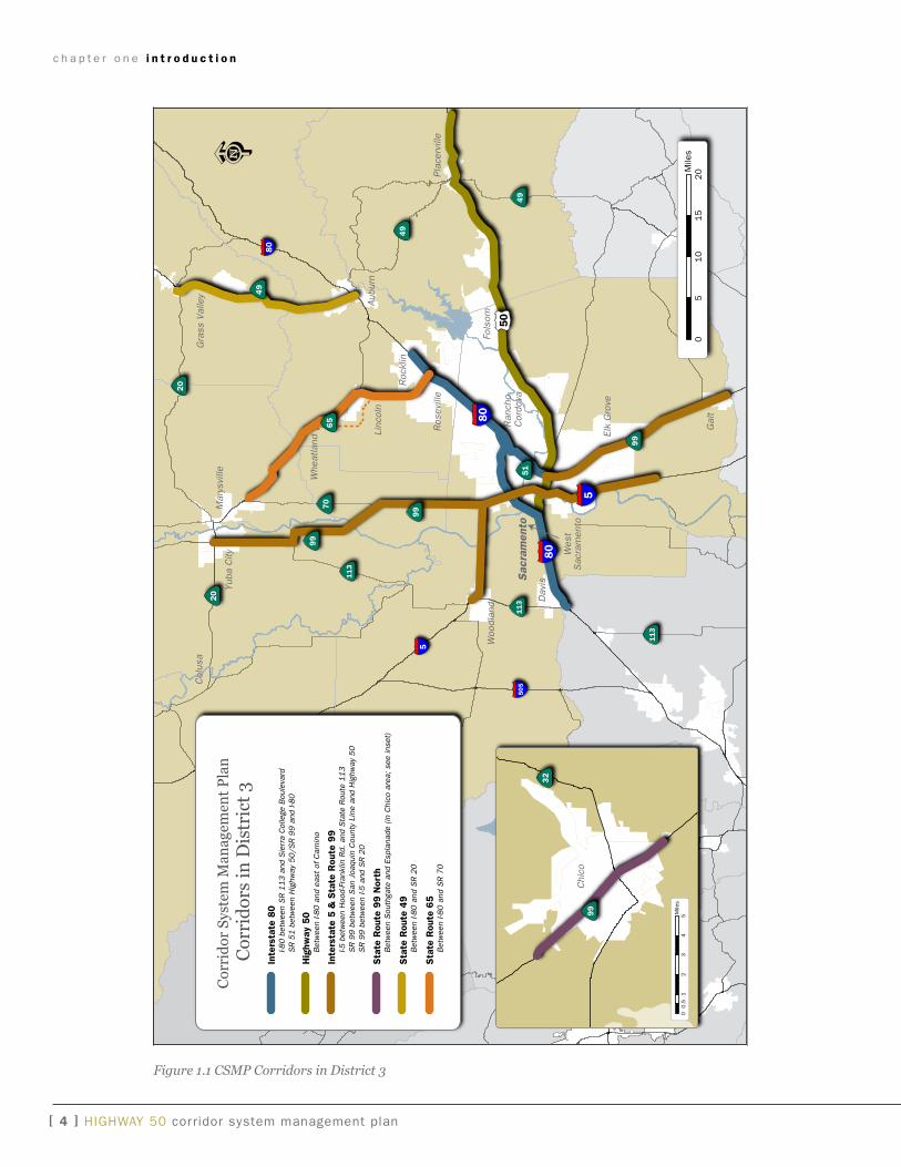
CSMPs are being developed throughout the State for cor-
ridors within which funding is being used from the Cor-
ridor Mobility improvement account (CMia) and Highway
99 Bond Programs. These Programs were created by
the passage of the Highway Safety, Traffic Reduction, air
Quality, and Port Security Bond act of 2006, approved by
the voters as Proposition 1B on November 7, 2006. The
intent is to eventually develop CSMPs for all congested
urban corridors. Figure 1.1 depicts the location of the
corridors for the CSMPs currently under development in
District 3.
The precise limits of each
CSMP will be determined
through a collaborative coop-
erative process involving the
major transportation planning
organizations and service
providers functioning within
the corridor.
The United States Highway 50 (US 50) CSMP addresses
the portion that begins at interstate 80 in west Sac-
ramento and extends east through Sacramento and El
Dorado Counties, ending at the Cedar grove interchange
in the community of Camino.
CSMPs are required
by the CTC to access
a part of the Propo-
sition 1B transpor-
tation funding that
California voters
approved in 2006.
c h a p t e r o n e i n t r o d u c t i o n
[ � ] HigHway 50 corridor system management plan
Figure 1.1 CSMP Corridors in District 3
50
5
80
80
80
5
50
5
99
99
29
29
11
3
22
1
11
3
11
3
99
70
49
49
65
20
20
20
53
49
51
Chi
co
Sac
ram
ento
Aub
urn
Yub
a C
ity
Mar
ysvi
lle
Ran
cho
Cor
dova
Col
usa
Woo
dlan
d
Pla
cerv
ille
Fols
om
Elk
Gro
ve
Gal
t
Ros
evill
e
Roc
klin
Linc
oln
Whe
atla
nd
Dav
is
Wes
tS
acra
men
to
Gra
ss V
alle
y
05
10
15
20M
iles
01
23
45
0.5
Mile
s
32
99
Cor
rid
or S
yste
m M
anag
emen
t P
lan
Cor
rid
ors
in D
istr
ict
3In
ters
tate
80
I-8
0 b
etw
een
SR
11
3 a
nd S
ierr
a C
olle
ge B
oule
vard
S
R 5
1 b
etw
een
Hig
hway
50
/SR
99
and
I-8
0
Hig
hway
50
B
etw
een
I-80
and
eas
t of
Cam
ino
Inte
rsta
te 5
& S
tate
Rou
te 9
9
I-5 b
etw
een
Hoo
d-Fr
ankl
in R
d. a
nd S
tate
Rou
te 1
13
S
R 9
9 b
etw
een
San
Joa
quin
Cou
nty
Line
and
Hig
hway
50
S
R 9
9 b
etw
een
I-5 a
nd S
R 2
0
Sta
te R
oute
99 N
orth
B
etw
een
Sou
thga
te a
nd E
spla
nade
(in
Chi
co a
rea;
see
inse
t)
Sta
te R
oute
49
B
etw
een
I-80
and
SR
20
Sta
te R
oute
65
B
etw
een
I-80
and
SR
70
c h a p t e r o n e i n t r o d u c t i o n
HigHway 50 corridor system management plan [ 5 ]
Development of each CSMP involves a six-step process:
• Defining the corridor system management plan trans-portation network including, but not limited to, State Highways, major local streets and roads, intercity rail service, regional rail service, regional transit service, and regional bicycle facilities.
• Summarizing existing travel conditions along the cor-ridor.
• Evaluating existing system management practices along the corridor.
• identifying major transportation challenges along the corridor.
• Preparing a corridor management strategy, includ-ing proposed detection and monitoring strategies, needed capital improvement projects, and defining the roles and responsibilities of each jurisdiction in the corridor development and management process.
• Completion of the final CSMP and use of the CSMP as part of the regional transportation planning pro-
cess.
in order to expedite the development of this process,
four working Papers will be developed culminating in the
draft and final US 50 CSMP. Each working Paper will
correspond with each of the first four CSMP development
steps and will be circulated for the review and comment
of major stakeholders. Once comments are received
back for each working Paper, the working Papers will
be revised and combined into a complete draft US 50
CSMP, which will then be circulated for a final round
of review and comment. The final US 50 CSMP will be
prepared thereafter for consideration into the regional
planning process by the applicable regional transporta-
tion planning agencies.
Caltrans has summarized the delivery schedule for all of
the CSMPs under development statewide using common
milestones. The following is an outline of the working
Papers and what issues will be addressed in each, in-
cluding an indication of which of the common milestones
is being met:
working Paper 1 provides an overview of the corridor
system management planning process and a definition
of the CSMP transportation network, including a ratio-
nale for the selection of the specific corridor limits and
modes to be included in the corridor planning process,
as well as a summary of improvement projects on the
corridor, which are already programmed, planned, or
conceptual.
milestone: CSMP Corridor Defined; Corridor Team Assembled
working Paper 2 will define the current services being
provided by the CSMP transportation network defined
in working Paper 1, propose performance measures for
the corridor, and provide baseline data regarding the
current CSMP transportation network for the proposed
performance measures.
milestone: Preliminary Performance Assessment
working Paper 3 will describe existing corridor manage-
ment activities, including all facilities and services cur-
rently in use to maximize mobility within and through the
corridor. These activities include traffic operations sys-
tems elements, facilities such as high occupancy vehicle
lanes, traveler information services, and transportation
demand management programs.
milestone: Detection in Place
working Paper 4 will provide an assessment of current
corridor performance by identifying the major problems
inhibiting efficient corridor operations for each element
(mode) of the CSMP transportation network.
milestone: Comprehensive Performance Assessment; Causality of Performance Degradation Identified
Draft and Final CSMPs will be prepared following comple-
tion of working Paper 4. The draft and final CSMP will
include highlights of working Papers 1 through 4, and
present the proposed corridor management strategy.
c h a p t e r o n e i n t r o d u c t i o n
[ � ] HigHway 50 corridor system management plan
This strategy will include the identification of proposed
multimodal corridor transportation improvements, the
roles and responsibilities for key stakeholders relative to
daily corridor system management, both today and in the
future, and the process for continuous corridor system
management planning.
milestone: Plan Completed and Accepted
1.2 BackgrOund
1.2.1 Need and Purpose of Corridor System Management Plan
The need for preparing CSMPs is to identify methods to
efficiently and effectively use all transportation modes
and facilities in congested corridors, to maximize mobil-
ity and reduce delay costs. California’s population is
projected to increase by twelve million new residents
over the next 20 years. Population growth, economic
expansion, and increasing travel demand have resulted
in congested travel corridors and the associated recur-
rent travel delay. Limited transportation resources
cannot keep pace with this increasing demand. Our re-
sources need to be invested in management strategies
and projects that will improve the performance of the
existing transportation system and reduce delay costs.
Restoring productivity is vital to the state, regional, and
local economy, and to the quality of life and safety for
travelers.
The purpose of preparing CSMPs is to reduce the antici-
pated increase in traffic congestion, improve safety, and
to preserve the mobility gains of the funding investments
for highway improvements under the Corridor Mobil-
ity improvement account (CMia) and Highway 99 Bond
programs. Both programs were established following the
passage of the transportation bond propositions in the
November 2006 election. The California Transportation
Commission (CTC) has since adopted guidelines and
adopted a program of projects for funding.
On March 15, 2007, the CTC adopted Resolution CMia-
P-0607-02. in Sections 2.12 and 2.13 of this resolu-
tion, the CTC resolved that “…the Commission expects
Caltrans and regional agencies to preserve the mobility
gains of urban corridor capacity improvements over time
that will be described in CSMPs, which may include the
installation of traffic detection equipment, the use of
ramp metering, operational improvements, and other
traffic management elements as appropriate…” and
“…the nominating agencies shall report the status of
development and implementation of the corridor system
management plans, including the installation of detec-
tion equipment and other supporting elements, to the
project delivery council on a semiannual basis…”.
1.2.2 Corridor System Management Planning Strategy
The corridor system management strategy exhibited in
each CSMP is based on the integration of system plan-
ning and system management.
System Planning is the long-range transportation plan-
ning process of Caltrans that evaluates the current and
future operating conditions and deficiencies on the State
transportation system. improvements are recommend-
ed to maintain mobility by minimizing or alleviating the
identified deficiencies. The process considers the entire
transportation system on and off the State Highway
System (SHS), including the highways and local arterials,
inter- and intra-city transit services, railroads, airports,
seaports, bicycling and walking, goods movement, intel-
ligent Transportation Systems (iTS), and local land use
and environmental issues.
System Management is the process of maximizing the
efficiency and effectiveness of the existing transporta-
tion infrastructure through use of proven methods and
technologies, which generally involve low capital or no
cost activities. a few examples include ramp metering,
traffic information collection and dissemination, incident
management, high occupancy vehicle lanes, use of lo-
cal arterial roadways that are parallel with the highway
c h a p t e r o n e i n t r o d u c t i o n
HigHway 50 corridor system management plan [ � ]
corridor, and demand management strategies, such
as transit and rideshare marketing, flexible work hour
schedules, and telecommuting.
The strategy of this CSMP requires a commitment by
Caltrans and applicable regional and local agencies to
develop and implement the CSMP.
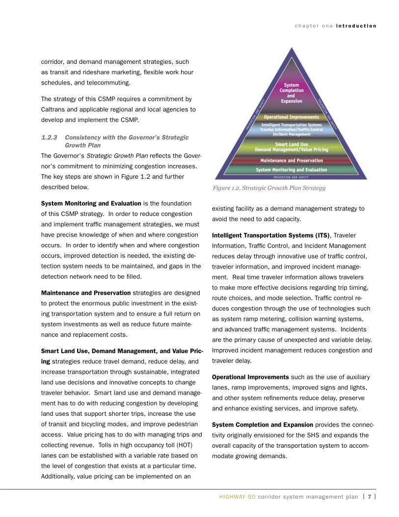
1.2.3 Consistency with the Governor’s Strategic Growth Plan
The governor’s Strategic Growth Plan reflects the gover-
nor’s commitment to minimizing congestion increases.
The key steps are shown in Figure 1.2 and further
described below.
system monitoring and evaluation is the foundation
of this CSMP strategy. in order to reduce congestion
and implement traffic management strategies, we must
have precise knowledge of when and where congestion
occurs. in order to identify when and where congestion
occurs, improved detection is needed, the existing de-
tection system needs to be maintained, and gaps in the
detection network need to be filled.
maintenance and preservation strategies are designed
to protect the enormous public investment in the exist-
ing transportation system and to ensure a full return on
system investments as well as reduce future mainte-
nance and replacement costs.
smart land use, demand management, and Value pric-
ing strategies reduce travel demand, reduce delay, and
increase transportation through sustainable, integrated
land use decisions and innovative concepts to change
traveler behavior. Smart land use and demand manage-
ment has to do with reducing congestion by developing
land uses that support shorter trips, increase the use
of transit and bicycling modes, and improve pedestrian
access. Value pricing has to do with managing trips and
collecting revenue. Tolls in high occupancy toll (HOT)
lanes can be established with a variable rate based on
the level of congestion that exists at a particular time.
additionally, value pricing can be implemented on an
existing facility as a demand management strategy to
avoid the need to add capacity.
Intelligent transportation systems (Its), Traveler
information, Traffic Control, and incident Management
reduces delay through innovative use of traffic control,
traveler information, and improved incident manage-
ment. Real time traveler information allows travelers
to make more effective decisions regarding trip timing,
route choices, and mode selection. Traffic control re-
duces congestion through the use of technologies such
as system ramp metering, collision warning systems,
and advanced traffic management systems. incidents
are the primary cause of unexpected and variable delay.
improved incident management reduces congestion and
traveler delay.
operational Improvements such as the use of auxiliary
lanes, ramp improvements, improved signs and lights,
and other system refinements reduce delay, preserve
and enhance existing services, and improve safety.
system Completion and expansion provides the connec-
tivity originally envisioned for the SHS and expands the
overall capacity of the transportation system to accom-
modate growing demands.
Figure 1.2, Strategic Growth Plan Strategy
c h a p t e r o n e i n t r o d u c t i o n
[ � ] HigHway 50 corridor system management plan
1.3 relatiOnship tO Other plans
There are a number of system planning and system
management documents that have been used as the
foundation for the preparation of this CSMP. The system
planning documents prepared by Caltrans include the
2005 California Transportation Plan (CTP), the 1998
interregional Transportation Strategic Plan (iTSP), the
2007-08 Caltrans California State Rail Plan, and several
District 3 plans that include the draft 2008 District Sys-
tem Management Plan (DSMP), the draft 2008 Trans-
portation System Development Program (TSDP), and
the draft 2008 US 50 Transportation Corridor Concept
Report (TCCR), which is currently under development.
System and regional planning documents prepared by
other agencies include the 2008 Metropolitan Transpor-
tation Plan 2035 (MTP 2035) and background informa-
tion including the project list for the 2008 MTP 2035 pre-
pared by the Sacramento area Council of governments
(SaCOg), the 2050 Blue Print Plan prepared by SaCOg,
the 2006 Regional goods Movement Study, Phase 1 pre-
pared by SaCOg, and the 2005 (2025) Regional Trans-
portation Plan (RTP) prepared by the El Dorado County
Transportation Commission (EDCTC).
There are also a number of system management docu-
ments that have been utilized in the development of
this CSMP. These documents include the 2008 Stra-
tegic growth Plan, the Traffic Operations Sytsem (TOS)
Element Plan, the 2004 Transportation Management
System Master Plan (TMSMP), the Traffic Management
System (TMS) Plan, the 2006 Ramp Meter Development
Plan, the 2006 State Highway Congestion Monitoring Re-
port (HiCOMP), the 2006 Traffic Monitoring Station (TMS)
Summary Report, and the 2004 California Statewide iTS
architecture.
in addition, there are numerous bicycle facilities within
and connecting to the US 50 corridor. Some of those
facilities are included in the CSMP transportation net-
work because they provide for mobility along the corridor;
however, the listing is not comprehensive. For a detailed
look at bicycle facilities in the area, the appropriate local
plan should be reviewed.
1.4 stakehOlder participatiOn
The development and successful implementation of the
CSMPs is dependent upon the close participation and
cooperation of all stakeholders.
internal and external stake-
holders for the US 50 corridor
are identified below and will
continue to participate in the
development of each working
Paper and the final CSMP. a
Project Development Team
has been formed and will
meet periodically to review
and comment on the work-
ing Papers, and to provide
direct technical assistance as
needed.
The internal and external stakeholders are further identi-
fied as follows:
internal stakeholders include Caltrans Headquarters
Traffic Operations (System Management Planning, intel-
ligent Transportation Systems, Traffic Safety, and System
Management Operations), Transportation Planning, Mass
Transportation, Caltrans District 3 Traffic Operations
(Traffic Management Center, Freeway Operations), Main-
tenance, and Transportation Planning (Travel Forecasting
and Modeling, System and Regional Planning), Program/
Project Management, and the neighboring Caltrans Dis-
tricts 4 (Bay area) and District 10 (northern San Joaquin
Valley).
External stakeholders include the Counties of yolo, Sac-
ramento and El Dorado, the Cities of west Sacramento,
Sacramento, Rancho Cordova, Folsom, and Placerville
as well as the El Dorado County Transportation Commis-
sion, the Sacramento area Council of governments, 50
Corridor Transportation Management association, the
Highway 50 Corridor Mobility Partnership, yolo Trans-
Stakeholders on US
50 Corridor:
SACOG , EDCTC,
Counties, Cities,
TMAs, Transit
Agencies, Bike
Advocates, Amtrak,
Port, Airports, CHP,
Chambers of Com-
merce and Caltrans
c h a p t e r o n e i n t r o d u c t i o n
HigHway 50 corridor system management plan [ � ]
portation Management association, El Dorado County
Transit authority, Folsom Stage Lines, Sacramento
Regional Transit District, yolo County Transportation
District, Sacramento County airport System, California
Highway Patrol, Port of Sacramento, amtrak and the
Capital Corridor Joint Powers authority, Sacramento area
Bicycle advocates, Folsom area Bicycle advocates, and
the Sacramento Metropolitan Chamber of Commerce.
1.5 csMp value tO stakehOlders
The CSMP process provides an opportunity for each
stakeholder to make more efficient use of its own
transportation system for which it has legal and financial
responsibility, while also working with its neighbors and
regional transportation partners to create a synergy re-
sulting in the more efficient and effective use of regional
resources. This will provide for a clearer link and un-
derstanding between the operational structure, system
deficiencies and needed improvements for each mode
within the corridor. Furthermore, this more detailed
understanding of the connections between regional
trips and local roadways will allow for better control and
prevention of trip diversions onto neighborhood streets.
also, most pending intelligent transportation system
(iTS) alternatives (for example, seamless traffic signal
synchronization, traveler information, etc.) traverse
jurisdictional boundaries and require jurisdictional input
and participation to be successful. ideally, the corridor-
approach to system management will allow the entire
system to operate more efficiently and will help reduce
congestion.
From a financial perspective, the concept of corridor
system planning is a priority for the California Transpor-
tation Commission (CTC). it remains to be seen what
role the CTC creates for CSMPs beyond CMia funding.
Nevertheless, participation with the “first generation”
CSMPs may position local agencies and transportation
advocates to more competitively access future funding
for transportation projects.
HigHway 50 corridor system management plan [ �� ]
a CRiTiCaL STEP iN THE CSMP PROCESS includes the
definition of the corridor transportation network, which
will be the focus of CSMP corridor improvement and
management activities. This chapter describes the indi-
vidual modes and roadway components of this network
and presents the rationale for their selection and inclu-
sion.
The following is applicable to all transportation modes
included as part of this CSMP:
• all State Highways in the corridor are proposed for inclusion in the CSMP transportation network based on the critical role of the State Highway System in providing interregional mobility for the majority of traf-fic between major activity centers.
• Freeway congestion causes some drivers to select alternatives, which often include parallel roads. in some instances, the neighborhood context or function of the roadway is not compatible with its use as a parallel facility. The integration of select parallel road-ways as part of the CSMP transportation network will allow for the better management of the entire system, including stronger control over the use of parallel roadways by drivers in concert with local needs.
• Encouraging the use of alternatives to the single occupant vehicle (SOV), including ridesharing and transit, is a critical component of the CSMP. where and when feasible as an alternative, corridor manage-ment activities will give priority to, and take action to encourage, operational strategies and capital projects that facilitate the use of SOV alternatives.
• Bicycle facilities contribute to the connectivity of the various transportation modes within the CSMP cor-ridor. Caltrans plans to work extensively with local agencies and bicycle advocates to determine the cor-rect bike routes to include in the CSMP.
2.1 us 50 cOrridOr liMits and ratiOnale
US 50 is a transcontinental highway that originates in
west Sacramento, California and terminates in Ocean
City, Maryland. US 50 is the key transportation artery
connecting yolo County with Sacramento County, con-
necting fast growing sub regions within Sacramento and
El Dorado Counties, and serving as a “Main artery”
through much of El Dorado
County.
The corridor for the US 50
CSMP begins where US 50
begins, at the US 50/inter-
state 80 (i-80) interchange in the City of west Sacramen-
to, and extends east to the US 50/Cedar grove inter-
change in the El Dorado County community of Camino.
These beginning and end points were selected based on
traffic and commute patterns,
level of service calculations, and input from stakehold-
ers.
chapter two
corridor definition and description
The US 50 CSMP
Corridor runs from
West Sacramento to
Camino.
[ �2 ] HigHway 50 corridor system management plan
2.2 criteria fOr including systeM el-eMents in the us 50 csMp trans-pOrtatiOn netwOrk
a diverse mixture of transportation modes and roadways
combine to provide mobility through the corridor, includ-
ing several State Highways and interchange ramp ter-
mini, major arterial roads, transit services, and bicycle
routes and facilities. along with State Highways, addi-
tional modes and roadways are proposed for inclusion
into the CSMP transportation network and must satisfy
the following criteria:
• Provide for mobility within or through the boundaries of this US 50 CSMP corridor,
• Major roadways, which:
• Provide capacity for corridor travel and are located roughly parallel to the State Highway in urban areas,
• Provide a realistic alternative for vehicle trips, which would predominantly use the State Highway were the roadway not available,
• Connect major parallel arterials included as part of the CSMP network with the State Highway,
• Primarily provide mobility between major activity cen-ters, and
• Have carrying capacity or throughput, or have poten-tial to add capacity.
• Transit and rail routes, which provide regularly sched-uled service between major activity centers,
• Bicycle routes and facilities, which provide for biking opportunities roughly parallel to the State Highway and key crossings of freeways, and
• The transportation mode or roadway could potentially be integrated into the coordinated corridor manage-
ment system.
The proposed boundaries and transportation modes
network for the US 50 CSMP are delineated on page 16
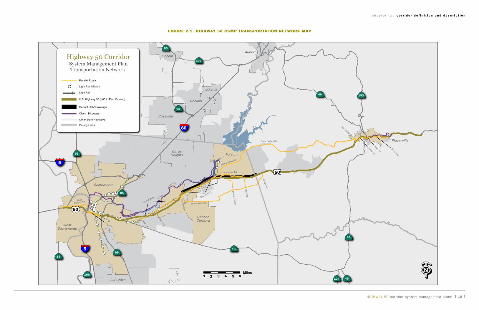
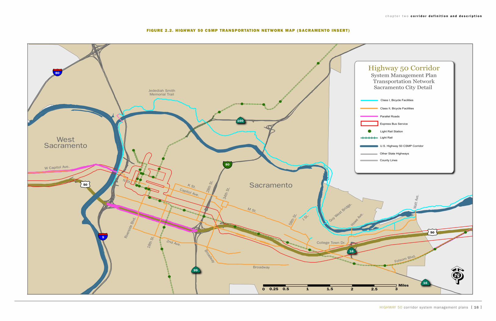
in Figure 2.1 and page 17 in Figure 2.2.
2.3 us 50 csMp transpOrtatiOn net-wOrk: state highway systeM
The portion of the State Highway System to be included
in this CSMP is US 50, beginning at the US 50 / i-80
merge in the City of west Sacramento in yolo County to
Cedar grove in the community of Camino in El Dorado
County. The highway traverses 52 miles through 3 coun-
ties: yolo (3.156 miles), Sacramento (23.136 miles) and
El Dorado (25.949 miles).
2.4 us 50 csMp transpOrtatiOn netwOrk: parallel rOadways
Based on the criteria listed in Section 2.2, and with
consideration of the need to consider the integrated
system and local needs, the major roads indicated in
Table 2.1 and in Figure 2.1 are proposed for inclusion in
the CSMP transportation network. The parallel connect-
ing roads have been categorized in a two-rank system.
Rank 1 roadways, or portions thereof, meet the above
listed criteria and are proposed for immediate inclusion
in the proposed initial network to be managed. Rank 2
roadways also appear to meet the general intent of the
criteria listed above; however, they are not proposed for
immediate inclusion in the CSMP transportation network
because they either do not have the vehicular capacity,
sufficient data available to assess its ability to function
as a parallel roadway, or for other reasons. Since the
corridor management planning and implementation is a
dynamic process, the roadways in Rank 2 will be con-
sidered for inclusion in the management system at the
appropriate time.
widening of white Rock Road has been identified as a
critical improvement by the 50 Corridor Mobility Partner-
ship (Partnership) in an effort to proactively address
transportation challenges of the Hwy 50 corridor in the
rapidly growing area of eastern Sacramento County
and western El Dorado County. The Partnership is a
cooperative effort by the County of Sacramento, City of
Rancho Cordova, City of Folsom, County of El Dorado,
and several private landowners including genCorp, Elliott
Homes, aKT Properties, and Carpenter Ranch. Serving
in an advisory capacity are Caltrans, SaCOg, and Sac-
ramento Regional Transit. The widening of white Rock
Road from grant Line Road to Prairie City Road is the
sole non-State Highway System project to be selected by
c h a p t e r t w o c o r r i d o r d e f i n i t i o n a n d d e s c r i p t i o n
HigHway 50 corridor system management plan [ �3 ]
the CTC to receive CMia funds.
widening white Rock Road to four lanes and improving
intersections is an opportunity to create much needed
parallel capacity to relieve congestion on Hwy 50. The
white Rock Road project alone will decrease peak period
delay on Hwy 50 by 18 percent. in addition, the project
will improve overall safety of the facility for all modes
of travel, improve connectivity between Hwy 50, Hwy
99, and interstate 5, and assist the region in meet-
ing air quality standards by reducing traffic congestion
on US 50 due to local use of white Rock Road. also,
the project will initiate the implementation of the Elk
grove-Rancho Cordova-El Dorado Connector and is an
important physical infrastructure improvement needed
to achieve the future economic development potential in
the corridor.
The major local arterials on page 21 in Table 2.2 are
proposed for inclusion in the CSMP transportation net-
work.
2.5 us 50 csMp transpOrtatiOn net-wOrk: transit and ridesharing
Encouraging the use of alternatives to the SOV, includ-
ing ridesharing and transit, is a critical component of the
CSMP. where and when feasible as an alternative, cor-
ridor management activities will give priority to, and take
action to encourage, operational strategies and capital
projects which facilitate the use of SOV alternatives.
The following rail and transit services are proposed for
inclusion in the CSMP transportation network:
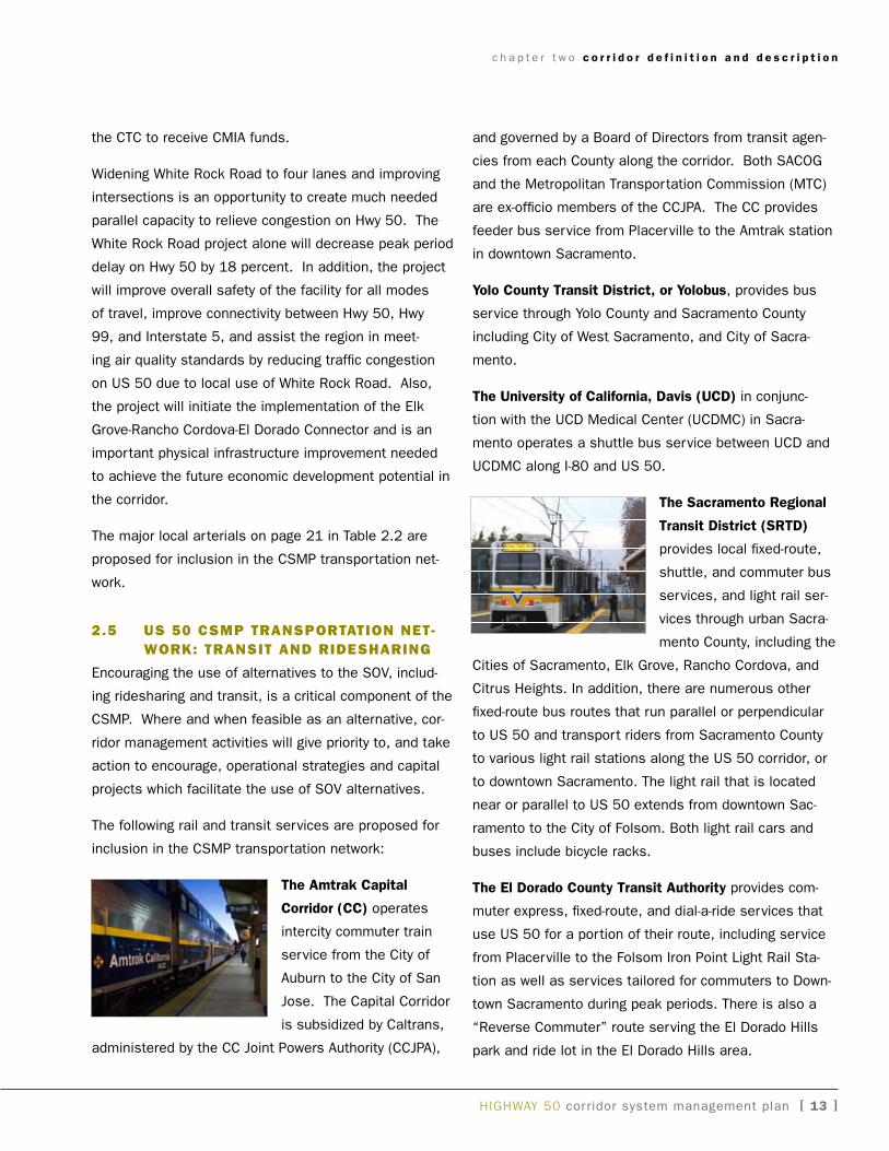
the amtrak Capital
Corridor (CC) operates
intercity commuter train
service from the City of
auburn to the City of San
Jose. The Capital Corridor
is subsidized by Caltrans,
administered by the CC Joint Powers authority (CCJPa),
and governed by a Board of Directors from transit agen-
cies from each County along the corridor. Both SaCOg
and the Metropolitan Transportation Commission (MTC)
are ex-officio members of the CCJPa. The CC provides
feeder bus service from Placerville to the amtrak station
in downtown Sacramento.
Yolo County transit district, or Yolobus, provides bus
service through yolo County and Sacramento County
including City of west Sacramento, and City of Sacra-
mento.
the university of California, davis (uCd) in conjunc-
tion with the UCD Medical Center (UCDMC) in Sacra-
mento operates a shuttle bus service between UCD and
UCDMC along i-80 and US 50.
the sacramento regional
transit district (srtd)
provides local fixed-route,
shuttle, and commuter bus
services, and light rail ser-
vices through urban Sacra-
mento County, including the
Cities of Sacramento, Elk grove, Rancho Cordova, and
Citrus Heights. in addition, there are numerous other
fixed-route bus routes that run parallel or perpendicular
to US 50 and transport riders from Sacramento County
to various light rail stations along the US 50 corridor, or
to downtown Sacramento. The light rail that is located
near or parallel to US 50 extends from downtown Sac-
ramento to the City of Folsom. Both light rail cars and
buses include bicycle racks.
the el dorado County transit authority provides com-
muter express, fixed-route, and dial-a-ride services that
use US 50 for a portion of their route, including service
from Placerville to the Folsom iron Point Light Rail Sta-
tion as well as services tailored for commuters to Down-
town Sacramento during peak periods. There is also a
“Reverse Commuter” route serving the El Dorado Hills
park and ride lot in the El Dorado Hills area.
c h a p t e r t w o c o r r i d o r d e f i n i t i o n a n d d e s c r i p t i o n
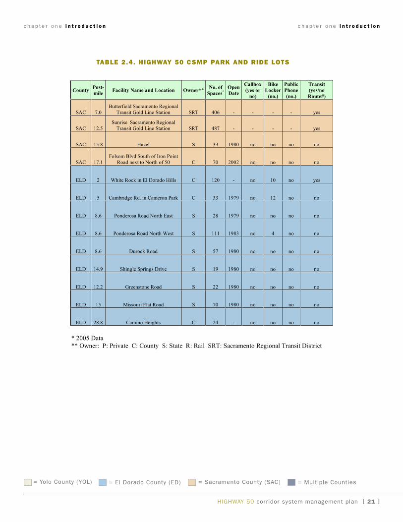
El Dorado Transit operates seven Park and Ride facili-
ties located in close proximity to US 50. These lots are
identified in Table 2.2, as are additional lots in El Dorado
and Sacramento Counties. Paratransit services focus on
addressing the needs of senior citizens and individuals
with disabilities or other limitations, which prevent use of
fixed-route transit.
Folsom Stage Lines operates a fixed-route bus service
within the City of Folsom, and also provides a Dial-a-
Ride curb-to-curb service for Folsom residents who have
a physical, developmental, or mental disability. Senior
citizens over 55 years old also qualify for the Dial-a-Ride
service. additional service includes light rail and Folsom
to downtown commuter services. Buses are wheelchair
accessible, and have front-mounted bicycle racks. Local
service connects with light rail at stations in the city of
Folsom.
2.5.1 Park and Ride Facilities
Park and Ride lots provide a place for drivers to park
their cars and connect with carpools, vanpools, and tran-
sit for work and other trips. Most are near major inter-
changes and three have bike lockers. There are eleven
Park and Ride lots located adjacent to or nearby the US
50 corridor, all of which are proposed for inclusion in the
CSMP transportation network. These facilities should
be utilized to improve the efficiency/effectiveness of the
system and reduce congestion by moving more people,
providing transportation choices, and enhancing multi-
modal connectivity. The Park and Ride lots are identified
in Table 2.2
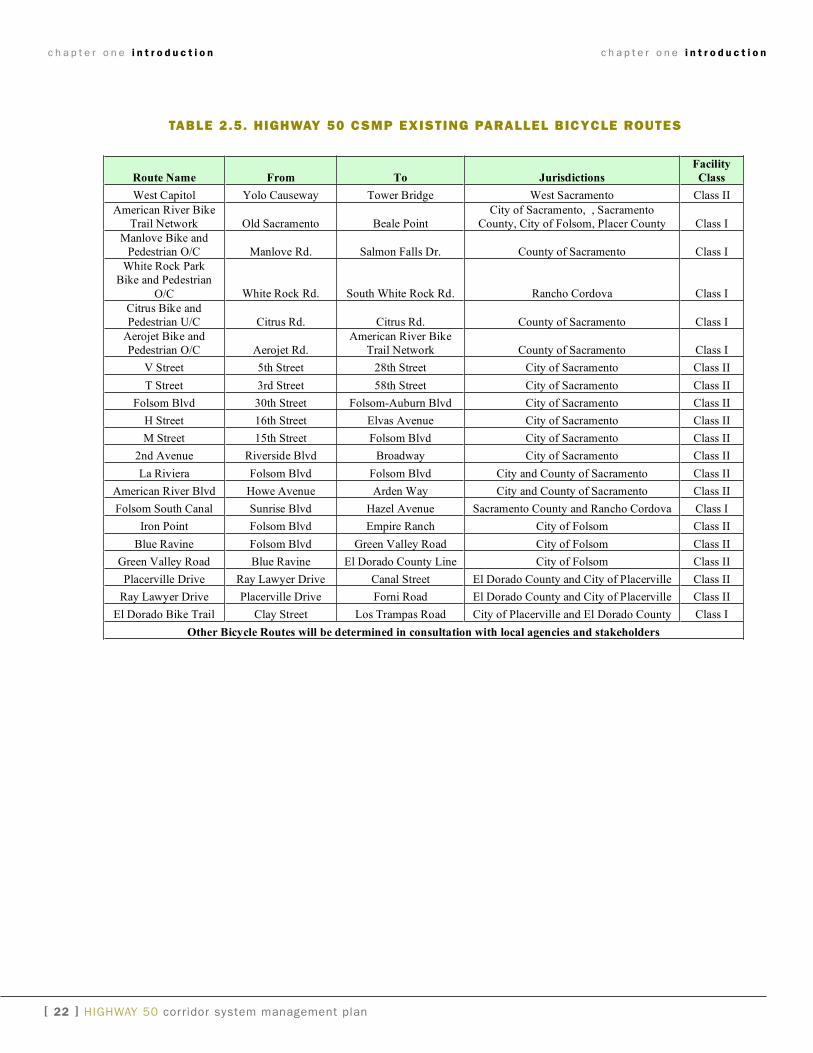
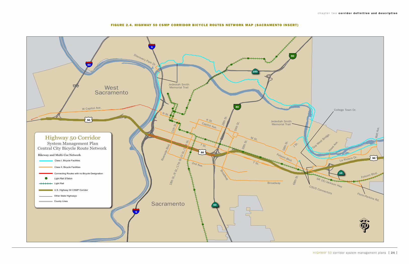
2.6 highway 50 csMp transpOrtatiOn netwOrk: existing parallel Bicycle rOutes
Bicycle facilities contribute to the connectivity of the vari-
ous modes of transportation within the CSMP corridor.
Bicycle facilities along the US 50 corridor include bicycle
routes adjacent to US 50. where portions of the State
Highway System are prohibited to bicycles and pedes-
trian traffic, alternative routes have been identified.
in addition to utilizing Caltrans highway data to identify
bicycle facilities on US 50, local bicycle master plans
from the cities, counties, Regional Transportation Plan-
ning agencies, and Metropolitan Planning Organizations
were used to identify Existing and Planned Class i Off-
Street Bike Paths, Class ii On-Street Bike Lanes, and
Class iii On-Street Shared Bike Routes.
a Class I bike path provides a completely separated
right of way for the exclusive use of bicycles and pedes-
trians with crossflow by motorists minimized.
a Class II bike lane provides a striped lane for one-way
bike travel on a street or highway.
a Class III bike route provides for shared use with
pedestrian or motor vehicle traffic.
Primary bicycle facilities proposed for inclusion in the
CSMP transportation network are described in Table 2.3.
c h a p t e r t w o c o r r i d o r d e f i n i t i o n a n d d e s c r i p t i o n
[ �� ] HigHway 50 corridor system management plan
HigHway 50 corridor system management plans [ 15 ]
Elk Grove
White Rock Rd.
Iron Point Rd.
MOTHER LODE DRCOUNTRY CLUB DR
MISSOURI FLAT RD
MADISON AVE
SERRANO PKWY
RAMP
RAMP
RAMP
RAMP
RAMP RAMP RA
MP
RA
MP
RAMP
RAMP
RAMP RAMP
RA
MP
R
AM
P
RA
MP
RAMP
RA
MP
RAMP
RAM
P
RA
MP
RAMP
RAMP
RAMP
RA
MP
R
AMP
RAMP
RA
MP
RAMP
RA
MP
RAMP
RA
MP
RAMP
RAMP
RAMP
RAMP RAMP
West
Capitol Ave Folsom Blvd. Folsom Blvd
.
Green Valley Rd.
Placerville Dr.
Forni Rd.Main St.
Broadway
Blue Ravine Rd.
70
99
84
160
99
80
193
49 193
49
49124
16
80
5
50
50
5
3RD
ST
BROADWAY
5TH
ST
24TH
ST
CAPITOL MALL
65TH
ST
S. R
IVE
R R
D
CAM
ERO
N PAR
K DR
W St.X St.
Watt Ave.
Bradshaw Rd.
Sunrise B
lvd.
Prairie City R
d.
Scott R
d.
Latrobe Rd.
WestSacramento
Sacramento
Lincoln
Loomis
RanchoCordova
Rocklin
Roseville
CitrusHeights
Auburn
Folsom
Placerville
Highway 50 CorridorSystem Management PlanTransportation Network
Parallel Roads
Light Rail STation
Light Rail
U.S. Highway 50 (I-80 to East Camino)
Current HOV Coverage
Other State Highways
County Lines
Class I Bikeways
65
65
5Miles
4321 6
c h a p t e r t w o c o r r i d o r d e f i n i t i o n a n d d e s c r i p t i o n
figure 2.1. highway 50 CSMP tranSPortation network MaP
HigHway 50 corridor system management plans [ 16 ]
0Miles
0.5 10.25 1.5 2 2.5 3
99
16
16
160
Broadway
J St.
N St.K St.
Capitol Ave.
M St.
2nd Ave.
Rive
rsid
e Bl
vd.
18th
St.
28th
St.
34th
St.
Broadway
58th
St.
Folsom Blvd.
Howe
Ave
.
Guy W
est B
ridge
.
Wat
t Ave
.
Jedediah SmithMemorial Trail
W Capitol Ave.
College Town Dr.
80
80
5
50
50
Sacramento
WestSacramento
Highway 50 CorridorSystem Management PlanTransportation NetworkSacramento City Detail
Parallel Roads
Class II, Bicycle Facilities
Class I, Bicycle Facilities
Light Rail
U.S. Highway 50 CSMP Corridor
Other State Highways
County Lines
Light Rail Station
Express Bus Service
c h a p t e r t w o c o r r i d o r d e f i n i t i o n a n d d e s c r i p t i o n
figure 2.2. highway 50 CSMP tranSPortation network MaP (SaCraMento inSert)
HigHway 50 corridor system management plans [ 17 ]
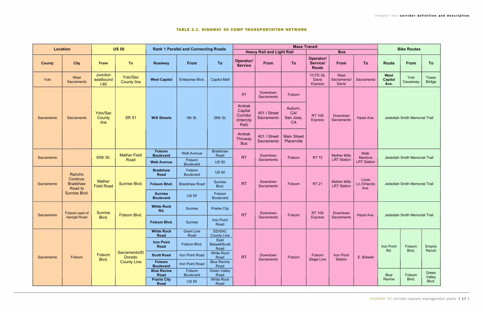
U.S. 50 Corridor System Management Plan
Table 2.1 US 50 CSMP Transportation Network
Mass TransitLocation US 50 Rank 1 Parallel and Connecting Roads
Heavy Rail and Light Rail BusBike Routes
County City From To Roadway From ToOperator/Service
From ToOperator/Service/Route
From To Route From To
YoloWest
Sacramento
Junctioneastbound
I-80
Yolo/SacCounty line
West Capitol Enterprise Blvd. Capitol MallYCTD 39,
DavisExpress
WestSacramento/
DavisSacramento
WestCapitol
Ave.
YoloCauseway
TowerBridge
RTDowntown
SacramentoFolsom
AmtrakCapitalCorridor(Intercity
Rail)
401 I StreetSacramento
Auburn,CA/
San Jose,CA
Sacramento Sacramento
Yolo/SacCounty
lineSR 51 W/X Streets 5th St. 26th St.
AmtrakThruway
Bus
401 I StreetSacramento
Main StreetPlacerville
RT 109Express
DowntownSacramento
Hazel Ave. Jedediah Smith Memorial Trail
FolsomBoulevard
Watt AvenueBradshaw
RoadSacramento 65th St.
Mather FieldRoad
Watt AvenueFolsom
BoulevardUS 50
RTDowntown
SacramentoFolsom RT 72
Mather MillsLRT Station
Watt-Manlove
LRT StationJedediah Smith Memorial Trail
Bradshaw
Road
Folsom
BoulevardUS 50
Folsom Blvd. Bradshaw RoadSunrise
Blvd.Sacramento
RanchoCordova:BradshawRoad to
Sunrise Blvd.
MatherField Road
Sunrise Blvd.
SunriseBoulevard
US 50Folsom
Boulevard
RTDowntown
SacramentoFolsom RT 21
Mather Mills
LRT Station
Louis
Ln./OrlandoAve.
Jedediah Smith Memorial Trail
White RockRd.
Sunrise Prairie City
SacramentoFolsom east ofAerojet Road
SunriseBlvd.
Folsom Blvd.
Folsom Blvd. SunriseIron Point
Road
RTDowntown
SacramentoFolsom
RT 109Express
DowntownSacramento
Hazel Ave. Jedediah Smith Memorial Trail
White RockRoad
Grant LineRoad
ED/SACCounty Line
Iron Point
RoadFolsom Blvd.
East
Bidwell/ScottRoad
Scott Road Iron Point RoadWhite Rock
Road
FolsomBoulevard
Iron Point RoadBlue Ravine
Road
Iron PointRd.
FolsomBlvd.
EmpireRanch
Blue RavineRoad
FolsomBoulevard
Green ValleyRoad
Sacramento FolsomFolsomBlvd.
Sacramento/ElDorado
County Line
Prairie CityRoad
US 50White Rock
Road
RTDowntown
SacramentoFolsom
FolsomStage Line
Iron PointStation
E. Bidwell
BlueRavine
FolsomBlvd.
GreenValleyBlvd.
c h a p t e r t w o c o r r i d o r d e f i n i t i o n a n d d e s c r i p t i o n
table 2.1. highway 50 CSMP tranSPortation network
HigHway 50 corridor system management plans [ 18 ]
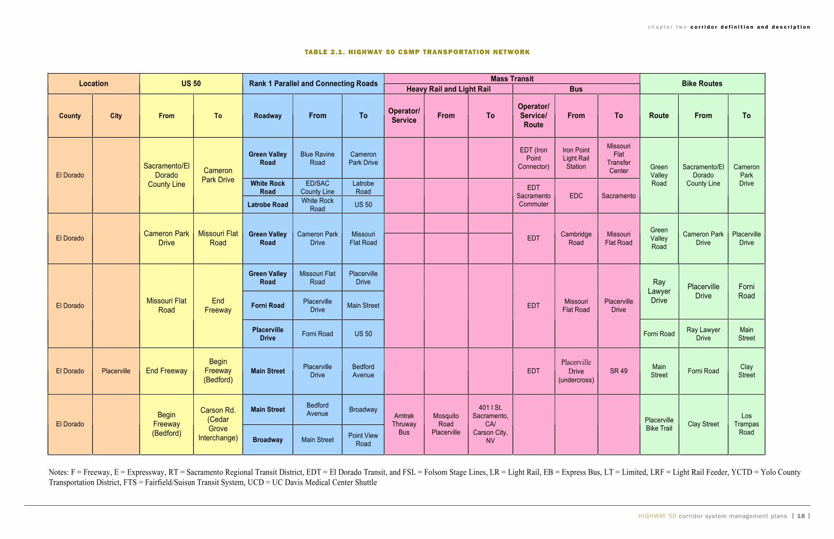
U.S. 50 Corridor System Management Plan
Table 2.1 US 50 CSMP Transportation Network
Mass TransitLocation US 50 Rank 1 Parallel and Connecting Roads
Heavy Rail and Light Rail BusBike Routes
County City From To Roadway From ToOperator/Service
From ToOperator/Service/Route
From To Route From To
Green ValleyRoad
Blue RavineRoad
CameronPark Drive
EDT (IronPoint
Connector)
Iron PointLight RailStation
MissouriFlat
TransferCenter
White RockRoad
ED/SACCounty Line
LatrobeRoad
El Dorado
Sacramento/ElDorado
County Line
CameronPark Drive
Latrobe RoadWhite Rock
RoadUS 50
EDTSacramentoCommuter
EDC Sacramento
GreenValleyRoad
Sacramento/ElDorado
County Line
CameronParkDrive
El DoradoCameron Park
DriveMissouri Flat
RoadGreen Valley
Road
Cameron Park
Drive
Missouri
Flat RoadEDT
Cambridge
Road
Missouri
Flat Road
Green
ValleyRoad
Cameron Park
Drive
Placerville
Drive
Green ValleyRoad
Missouri FlatRoad
PlacervilleDrive
Forni RoadPlacerville
DriveMain Street
RayLawyerDrive
PlacervilleDrive
ForniRoad
El DoradoMissouri Flat
RoadEnd
Freeway
PlacervilleDrive
Forni Road US 50
EDTMissouri
Flat RoadPlacerville
Drive
Forni RoadRay Lawyer
DriveMainStreet
El Dorado Placerville End FreewayBegin
Freeway(Bedford)
Main StreetPlacerville
DriveBedfordAvenue
EDT
Placerville
Drive
(undercross)
SR 49MainStreet
Forni RoadClay
Street
Main StreetBedfordAvenue
Broadway
El Dorado
BeginFreeway(Bedford)
Carson Rd.(CedarGrove
Interchange) Broadway Main StreetPoint View
Road
AmtrakThruway
Bus
MosquitoRoad
Placerville
401 I St.Sacramento,
CA/
Carson City,NV
PlacervilleBike Trail
Clay StreetLos
TrampasRoad
Notes: F = Freeway, E = Expressway, RT = Sacramento Regional Transit District, EDT = El Dorado Transit, and FSL = Folsom Stage Lines, LR = Light Rail, EB = Express Bus, LT = Limited, LRF = Light Rail Feeder, YCTD = Yolo County
Transportation District, FTS = Fairfield/Suisun Transit System, UCD = UC Davis Medical Center Shuttle
c h a p t e r t w o c o r r i d o r d e f i n i t i o n a n d d e s c r i p t i o n
table 2.1. highway 50 CSMP tranSPortation network
c h a p t e r o n e i n t r o d u c t i o n
HigHway 50 corridor system management plan [ �� ]
c h a p t e r t w o c o r r i d o r d e f i n i t i o n a n d d e s c r i p t i o n
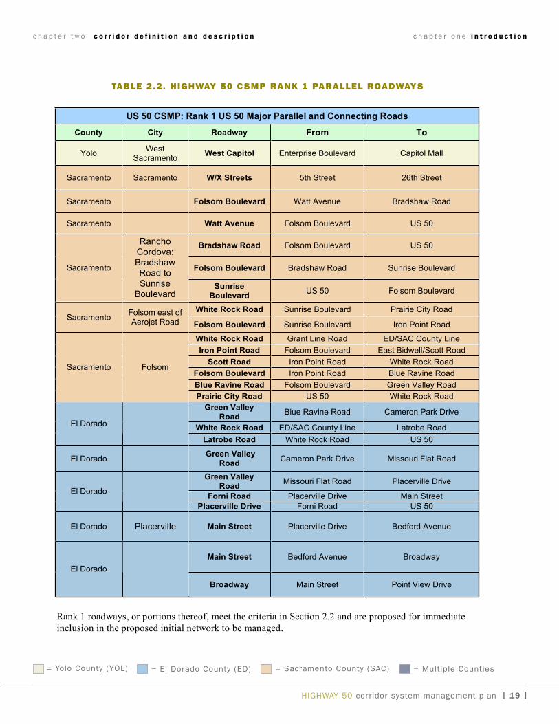
U.S. 50 Corridor System Management Plan
Table 2.2 US 50 CSMP Rank 1 Major Parallel and Connecting Roads
US 50 CSMP: Rank 1 US 50 Major Parallel and Connecting Roads
County City Roadway From To
YoloWest
SacramentoWest Capitol Enterprise Boulevard Capitol Mall
Sacramento Sacramento W/X Streets 5th Street 26th Street
Sacramento Folsom Boulevard Watt Avenue Bradshaw Road
Sacramento Watt Avenue Folsom Boulevard US 50
Bradshaw Road Folsom Boulevard US 50
Folsom Boulevard Bradshaw Road Sunrise BoulevardSacramento
RanchoCordova:BradshawRoad toSunrise
BoulevardSunrise
BoulevardUS 50 Folsom Boulevard
White Rock Road Sunrise Boulevard Prairie City RoadSacramento
Folsom east ofAerojet Road Folsom Boulevard Sunrise Boulevard Iron Point Road
White Rock Road Grant Line Road ED/SAC County Line
Iron Point Road Folsom Boulevard East Bidwell/Scott Road
Scott Road Iron Point Road White Rock Road
Folsom Boulevard Iron Point Road Blue Ravine Road
Blue Ravine Road Folsom Boulevard Green Valley Road
Sacramento Folsom
Prairie City Road US 50 White Rock Road
Green ValleyRoad
Blue Ravine Road Cameron Park Drive
White Rock Road ED/SAC County Line Latrobe RoadEl Dorado
Latrobe Road White Rock Road US 50
El DoradoGreen Valley
RoadCameron Park Drive Missouri Flat Road
Green ValleyRoad
Missouri Flat Road Placerville Drive
Forni Road Placerville Drive Main StreetEl Dorado
Placerville Drive Forni Road US 50
El Dorado Placerville Main Street Placerville Drive Bedford Avenue
Main Street Bedford Avenue Broadway
El Dorado
Broadway Main Street Point View Drive
Rank 1 roadways, or portions thereof, meet the criteria in Section 2.2 and are proposed for immediate
inclusion in the proposed initial network to be managed.
taBle 2.2. highway 50 csMp rank 1 parallel rOadways
= yolo County (yOL) = El Dorado County (ED) = Sacramento County (SaC) = Multiple Counties
c h a p t e r o n e i n t r o d u c t i o n
[ 20 ] HigHway 50 corridor system management plan
c h a p t e r t w o c o r r i d o r d e f i n i t i o n a n d d e s c r i p t i o n
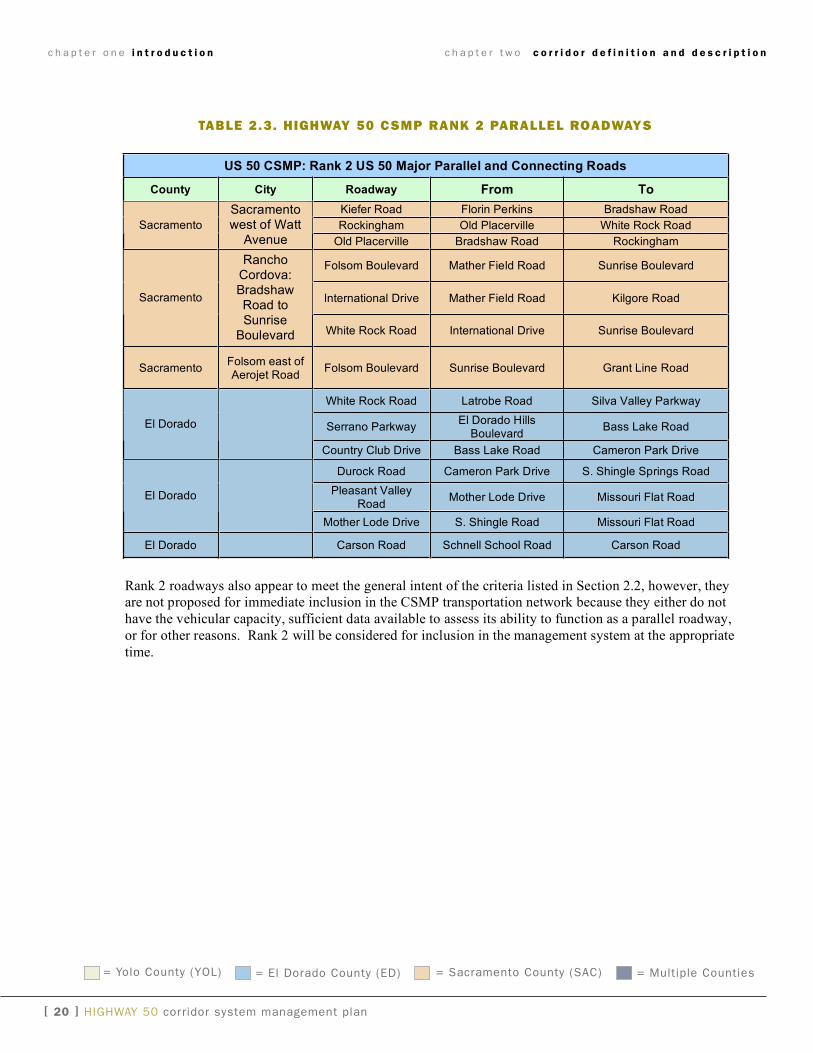
taBle 2.3. highway 50 csMp rank 2 parallel rOadways
U.S. 50 Corridor System Management Plan
Table 2.3 US 50 CSMP Proposed Rank 2 Major Parallel and Connecting Roads
US 50 CSMP: Rank 2 US 50 Major Parallel and Connecting Roads
County City Roadway From To
Kiefer Road Florin Perkins Bradshaw Road
Rockingham Old Placerville White Rock RoadSacramento
Sacramentowest of Watt
Avenue Old Placerville Bradshaw Road Rockingham
Folsom Boulevard Mather Field Road Sunrise Boulevard
International Drive Mather Field Road Kilgore RoadSacramento
RanchoCordova:BradshawRoad toSunrise
Boulevard White Rock Road International Drive Sunrise Boulevard
SacramentoFolsom east ofAerojet Road
Folsom Boulevard Sunrise Boulevard Grant Line Road
White Rock Road Latrobe Road Silva Valley Parkway
Serrano ParkwayEl Dorado Hills
BoulevardBass Lake RoadEl Dorado
Country Club Drive Bass Lake Road Cameron Park Drive
Durock Road Cameron Park Drive S. Shingle Springs Road
Pleasant ValleyRoad
Mother Lode Drive Missouri Flat RoadEl Dorado
Mother Lode Drive S. Shingle Road Missouri Flat Road
El Dorado Carson Road Schnell School Road Carson Road
Rank 2 roadways also appear to meet the general intent of the criteria listed in Section 2.2, however, they
are not proposed for immediate inclusion in the CSMP transportation network because they either do not
have the vehicular capacity, sufficient data available to assess its ability to function as a parallel roadway,
or for other reasons. Rank 2 will be considered for inclusion in the management system at the appropriate
time.
= yolo County (yOL) = El Dorado County (ED) = Sacramento County (SaC) = Multiple Counties
c h a p t e r o n e i n t r o d u c t i o n
HigHway 50 corridor system management plan [ 2� ]
U.S. 50 Corridor System Management Plan
Page 5
Table 2.4 US 50 CSMP Park and Ride Lots
* 2005 Data
** Owner: P: Private C: County S: State R: Rail SRT: Sacramento Regional Transit District
CountyPost-
mileFacility Name and Location Owner**
No. of
Spaces*
Open
Date
Callbox
(yes or
no)
Bike
Locker
(no.)
Public
Phone
(no.)
Transit
(yes/no
Route#)
SAC 7.0
Butterfield Sacramento Regional
Transit Gold Line Station SRT 406 - - - - yes
SAC 12.5
Sunrise Sacramento Regional
Transit Gold Line Station SRT 487 - - - - yes
SAC 15.8 Hazel S 33 1980 no no no no
SAC 17.1
Folsom Blvd South of Iron Point
Road next to North of 50 C 70 2002 no no no no
ELD 2 White Rock in El Dorado Hills C 120 - no 10 no yes
ELD 5 Cambridge Rd. in Cameron Park C 33 1979 no 12 no no
ELD 8.6 Ponderosa Road North East S 28 1979 no no no no
ELD 8.6 Ponderosa Road North West S 111 1983 no 4 no no
ELD 8.6 Durock Road S 57 1980 no no no no
ELD 14.9 Shingle Springs Drive S 19 1980 no no no no
ELD 12.2 Greenstone Road S 22 1980 no no no no
ELD 15 Missouri Flat Road S 70 1980 no no no no
ELD 28.8 Camino Heights C 24 - no no no no
taBle 2.4. highway 50 csMp park and ride lOts
c h a p t e r o n e i n t r o d u c t i o n
= yolo County (yOL) = El Dorado County (ED) = Sacramento County (SaC) = Multiple Counties
c h a p t e r o n e i n t r o d u c t i o n
[ 22 ] HigHway 50 corridor system management plan
U.S. 50 Corridor System Management Plan
Table 2.5 US 50 CSMP Parallel Bicycle Routes and Bicycle Crossings
Route Name From To Jurisdictions
Facility
Class
West Capitol Yolo Causeway Tower Bridge West Sacramento Class II
American River Bike
Trail Network Old Sacramento Beale Point
City of Sacramento, , Sacramento
County, City of Folsom, Placer County Class I
Manlove Bike and
Pedestrian O/C Manlove Rd. Salmon Falls Dr. County of Sacramento Class I
White Rock Park
Bike and Pedestrian
O/C White Rock Rd. South White Rock Rd. Rancho Cordova Class I
Citrus Bike and
Pedestrian U/C Citrus Rd. Citrus Rd. County of Sacramento Class I
Aerojet Bike and
Pedestrian O/C Aerojet Rd.
American River Bike
Trail Network County of Sacramento Class I
V Street 5th Street 28th Street City of Sacramento Class II
T Street 3rd Street 58th Street City of Sacramento Class II
Folsom Blvd 30th Street Folsom-Auburn Blvd City of Sacramento Class II
H Street 16th Street Elvas Avenue City of Sacramento Class II
M Street 15th Street Folsom Blvd City of Sacramento Class II
2nd Avenue Riverside Blvd Broadway City of Sacramento Class II
La Riviera Folsom Blvd Folsom Blvd City and County of Sacramento Class II
American River Blvd Howe Avenue Arden Way City and County of Sacramento Class II
Folsom South Canal Sunrise Blvd Hazel Avenue Sacramento County and Rancho Cordova Class I
Iron Point Folsom Blvd Empire Ranch City of Folsom Class II
Blue Ravine Folsom Blvd Green Valley Road City of Folsom Class II
Green Valley Road Blue Ravine El Dorado County Line City of Folsom Class II
Placerville Drive Ray Lawyer Drive Canal Street El Dorado County and City of Placerville Class II
Ray Lawyer Drive Placerville Drive Forni Road El Dorado County and City of Placerville Class II
El Dorado Bike Trail Clay Street Los Trampas Road City of Placerville and El Dorado County Class I
Other Bicycle Routes will be determined in consultation with local agencies and stakeholders
taBle 2.5. highway 50 csMp existing parallel Bicycle rOutes
c h a p t e r o n e i n t r o d u c t i o n
HigHway 50 corridor system management plans [ 23 ]
c h a p t e r t w o c o r r i d o r d e f i n i t i o n a n d d e s c r i p t i o n
figure 2.3. highway 50 CSMP Corridor biCyCle routeS network MaP
HigHway 50 corridor system management plans [ 24 ]
[DRAFT]
Broadway
J St.
16
Jedediah SmithMemorial Trail
N St.
K St.Capitol Ave.
M St.
T St.
2nd Ave.
Folsom Blvd.T St.
SR 16/Jackson Hwy
11th
St.
Rive
rsid
e Bl
vd.
18th
St./
R St
./17
th S
t./O
St./
18th
St.
28th
St.
34th
St.
39th
St.
Broadway
58th
St.
Jedediah SmithMemorial Trail
68th
St.
CSUS Connectors Florin-Perkins Rd.
Folsom Blvd.
La Riviera Dr.
Howe
Ave
.
Guy W
est B
ridge
.
Wat
t Av
e.
College Town Dr.
Highway 50 CorridorSystem Management Plan
Central City Bicycle Route Network
Connecting Routes with no Bicycle Designation
Class II, Bicycle Facilities
Class I, Bicycle Facilities
Light Rail
U.S. Highway 50 CSMP Corridor
Bikeway and Multi-Use Network
Other State Highways
County Lines
Light Rail STation
99
160
Sacramento
WestSacramento
W Capitol Ave.
Discovery Park Dr.
80
80
50
5
80
5
50
50
c h a p t e r t w o c o r r i d o r d e f i n i t i o n a n d d e s c r i p t i o n
figure 2.4. highway 50 CSMP Corridor biCyCle routeS network MaP (SaCraMento inSert)
chapter three
programmed, planned and conceptual projects
The CSMP is being developed in a dynamic environment
wherein many improvements directly or indirectly impact-
ing the proposed CSMP transportation network are un-
der development or in construction. These improvement
projects are either fully or partially programmed (funded),
planned (usually without specific funding sources identi-
fied), or conceptual. it should be noted that the projects
listed below do not include operations, maintenance,
planning studies, rolling transit stock replacement, and
unspecified lump sum distributions.
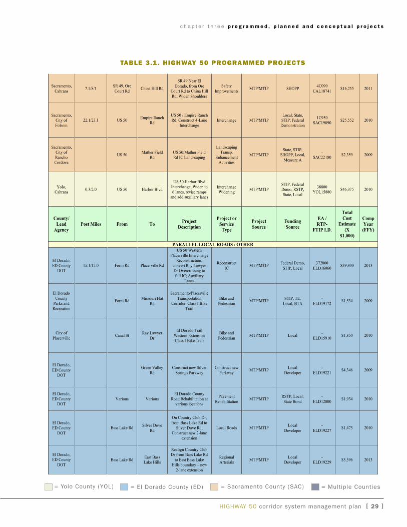
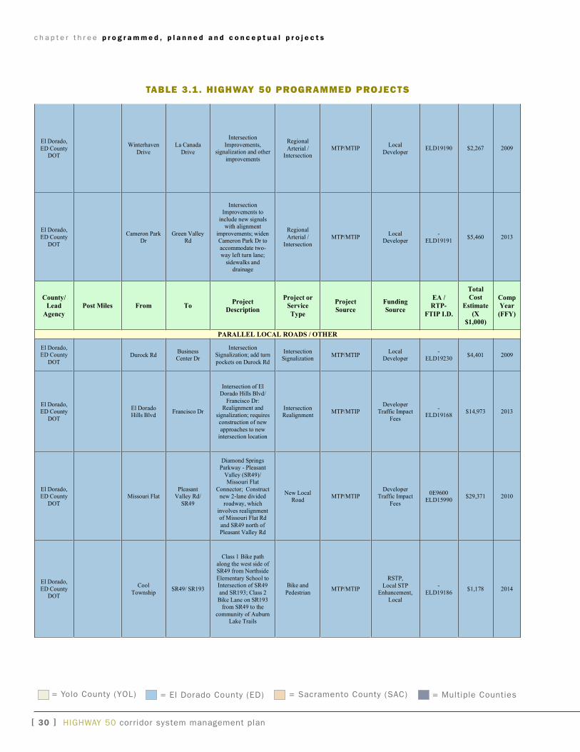
3.1 prOgraMMed prOjects
“Programmed” improvements are those projects with
guaranteed funding for either all or part of the total
project costs.
Utilizing the above selection criteria, numerous projects
were identified. Key projects include HOV lanes from
the El Dorado County line to the Bass Lake Road inter-
change, HOV lanes from Sunrise Boulevard to downtown
Sacramento, auxiliary lanes from Sunrise to Folsom
Boulevard, and improving white Rock Road to 4 lanes
from grant Line Road to Prairie City Road. Develop-
ment of transit services is also a significant element in
CSMP corridor management for US 50, which includes
bus acquisitions, new, transit routes and transit station
upgrades. These improvements will enhance transit con-
nectivity and further integrate multimodal options into
corridor management strategies. Other priority projects
include major rehabilitation to various sections of US 50,
traffic operations system projects such as placement
of ramp meters and traffic monitoring stations, transit
projects such as the purchase of additional commuter
buses, and light rail projects. Note: MTP = Metropolitan
Transportation Plan, MTiP = Metropolitan Transportation
improvement Plan.
3.2 planned prOjects
“Planned” improvements are those projects included in
the applicable metropolitan or regional transportation
plans (MTP or RTP), or the 2007 Ten-year State High-
ways Operation and Protection Program (SHOPP) Plan.
3.3 cOnceptual prOjects
“Conceptual” improvements are those projects included
in a planning document other than a MTP, RTP, or the
Ten-year SHOPP. Note: TSDP = Transportation System
Development Program.
HigHway 50 corridor system management plan [25 ]
c h a p t e r t h r e e p r o g r a m m e d , p l a n n e d a n d c o n c e p t u a l p r o j e c t s
[ 2� ] HigHway 50 corridor system management plan
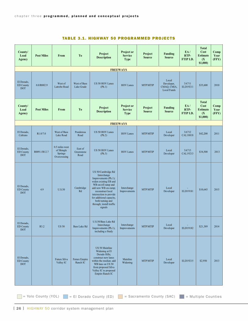
Table 3.1a Programmed Projects
County/
Lead
Agency
Post Miles From ToProject
Description
Project or
Service
Type
Project
Source
Funding
Source
EA /
RTP-
FTIP I.D.
Total
Cost
Estimate
(X
$1,000)
Comp
Year
(FFY)
FREEWAYS
El Dorado,
ED CountyDOT
0.0/R002.9West of
Latrobe Road
West of Bass
Lake Grade
US 50 HOV Lanes
(Ph.1)HOV Lanes MTP/MTIP
Local
Developer,CMAQ, CMIA,
Local Funds
3A711
ELD19211$35,600 2010
County/
Lead
Agency
Post Miles From ToProject
Description
Project or
Service
Type
Project
Source
Funding
Source
EA /
RTP-
FTIP I.D.
Total
Cost
Estimate
(X
$1,000)
Comp
Year
(FFY)
FREEWAYS
El Dorado,Caltrans
R1.0/7.0West of BassLake Road
PonderosaRoad
US 50 HOV Lanes(Ph.2)
HOV Lanes MTP/MTIPLocal
Developer3A712
CAL18818$42,200 2011
El Dorado,
ED CountyDOT
R009.1/R12.7
0.5 miles west
of ShingleSprings
Overcrossing
East of
GreenstoneRoad
US 50 HOV Lanes
(Ph.3)HOV Lanes MTP/MTIP
Local
Developer
3A713
CAL19213$34,500 2013
El Dorado,
ED CountyDOT
4.9 U.S.50Cambridge
Rd
US 50/Cambridge Rd
InterchangeImprovements (Ph.1);
widen existing EB andWB on/off ramp and
add new WB on-ramp;
reconstruct localintersection to provide
for additional capacity,both turning and
through; install trafficsignals
Interchange
ImprovementsMTP/MTIP
Local
Developer
-
ELD19181$10,645 2015
El Dorado,
ED CountyDOT
R3.2 US 50 Bass Lake Rd
U.S.50/Bass Lake Rd
InterchangeImprovements (Ph.1),
including a Study
Interchange
ImprovementsMTP/MTIP
Local
Developer
-
ELD19182$21,389 2014
El Dorado,
ED CountyDOT
Future Silva
Valley IC
Future Empire
Ranch IC
US 50 Mainline
Widening at ElDorado Hills;
construct new laneswithin the median; add
WB lane on US 50from proposed Silva
Valley IC to proposedEmpire Ranch IC
Mainline
WideningMTP/MTIP
Local
DeveloperELD19215 $2,950 2013
taBle 3.1. highway 50 prOgraMMed prOjects
= yolo County (yOL) = El Dorado County (ED) = Sacramento County (SaC) = Multiple Counties
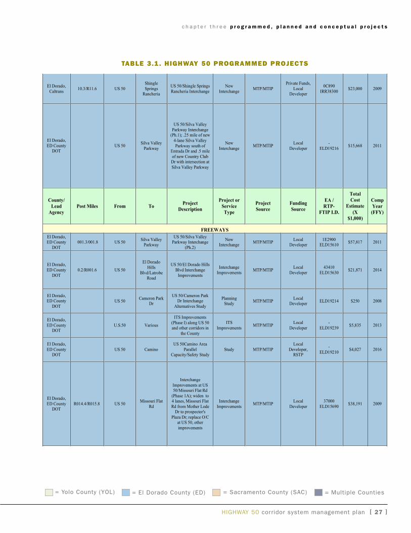
HigHway 50 corridor system management plan [ 2� ]
c h a p t e r t h r e e p r o g r a m m e d , p l a n n e d a n d c o n c e p t u a l p r o j e c t s
El Dorado,
Caltrans10.3/R11.6 US 50
Shingle
SpringsRancheria
US 50/Shingle Springs
Rancheria Interchange
New
InterchangeMTP/MTIP
Private Funds,
LocalDeveloper
0C890
IRR38300$23,000 2009
El Dorado,
ED CountyDOT
US 50Silva Valley
Parkway
US 50/Silva Valley
Parkway Interchange(Ph.1); .25 mile of new
4-lane Silva Valley
Parkway south ofEntrada Dr and .5 mile
of new Country ClubDr with intersection at
Silva Valley Parkway
New
InterchangeMTP/MTIP
Local
Developer
-
ELD19216$15,668 2011
County/
Lead
Agency
Post Miles From ToProject
Description
Project or
Service
Type
Project
Source
Funding
Source
EA /
RTP-
FTIP I.D.
Total
Cost
Estimate
(X
$1,000)
Comp
Year
(FFY)
FREEWAYS
El Dorado,ED County
DOT
001.3/001.8 US 50Silva Valley
Parkway
US 50/Silva ValleyParkway Interchange
(Ph.2)
NewInterchange
MTP/MTIPLocal
Developer1E2900
ELD15610$57,817 2011
El Dorado,
ED County
DOT
0.2/R001.6 US 50
El Dorado
Hills
Blvd/LatrobeRoad
US 50/El Dorado Hills
Blvd Interchange
Improvements
Interchange
ImprovementsMTP/MTIP
Local
Developer
43410
ELD15630$21,871 2014
El Dorado,ED County
DOTUS 50
Cameron ParkDr
US 50/Cameron ParkDr Interchange
Alternatives Study
PlanningStudy
MTP/MTIPLocal
DeveloperELD19214 $250 2008
El Dorado,
ED CountyDOT
U.S.50 Various
ITS Improvements
(Phase I) along US 50and other corridors in
the County
ITS
ImprovementsMTP/MTIP
Local
Developer
-
ELD19239$5,835 2013
El Dorado,
ED CountyDOT
US 50 Camino
US 50Camino Area
ParallelCapacity/Safety Study
Study MTP/MTIP
Local
Developer,RSTP
-
ELD19210$4,027 2016
El Dorado,
ED CountyDOT
R014.4/R015.8 US 50Missouri Flat
Rd
Interchange
Improvements at US50/Missouri Flat Rd
(Phase 1A); widen to4 lanes, Missouri Flat
Rd from Mother LodeDr to prospector's
Plaza Dr; replace O/Cat US 50, other
improvements
Interchange
ImprovementsMTP/MTIP
Local
Developer
37000
ELD15690$38,191 2009
taBle 3.1. highway 50 prOgraMMed prOjects
= yolo County (yOL) = El Dorado County (ED) = Sacramento County (SaC) = Multiple Counties
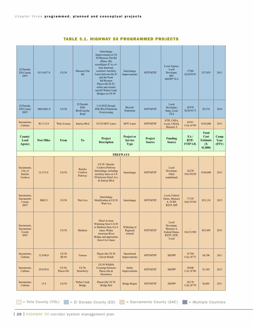
c h a p t e r t h r e e p r o g r a m m e d , p l a n n e d a n d c o n c e p t u a l p r o j e c t s
[ 2� ] HigHway 50 corridor system management plan
El Dorado,
ED CountyDOT
015.4/017.0 US 50Missouri Flat
Rd
Interchange
Improvements at US50/Missouri Flat Rd
(Phase 1B);reconfigure IC to a 4-
lane diamond,construct Auxiliary
Lanes between the ICand the Forni
Rd/WesternPlacerville Dr IC;
widen and seismicretrofit Weber Creek
Bridges on US 50
Interchange
ImprovementsMTP/MTIP
Local Agency,
LocalDeveloper,
RIP,SHOPP TEA
37280
ELD19193$37,859 2011
El Dorado,ED County
DOT000.8/001.0 US 50
El DoradoHills
Blvd/LatrobeRoad
U.S.50/El DoradoHills Blvd Pedestrian
Overcrossing
Bicycle/
PedestrianMTP/MTIP
LocalDeveloper,
State, LocalTEA
2E470
ELD19173$5,574 2014
Sacramento,
CaltransR5.3/12.8 Watt Avenue Sunrise Blvd US 50 HOV Lanes HOV Lanes MTP/MTIP
STIP, CMIA,
Local, CMAQ,Measure A
44161
CAL16790$165,000 2013
County/
Lead
Agency
Post Miles From ToProject
Description
Project or
Service
Type
Project
Source
Funding
Source
EA /
RTP-
FTIP I.D.
Total
Cost
Estimate
(X
$1,000)
Comp
Year
(FFY)
FREEWAYS
Sacramento,City of
Rancho
Cordova
12.5/15.8 US 50
RanchoCordova
Parkway
US 50 / RanchoCordova Parkway
Interchange, including
auxiliary lanes on US50 between Hazel Ave
& Sunrise Blvd
Interchange MTP/MTIP
LocalDeveloper,
Other
(undefined)
1E270SAC24220
$104,000 2013
Sacramento,
SacramentoCounty
DOT
R005.3 US 50 Watt Ave
Interchange
Modification at US 50/Watt Ave
Interchange MTP/MTIP
Local, Federal
Demo, MeasureA, TCRP,
RSTP, RIP
37120
SAC19350$53,134 2013
Sacramento,
SacramentoCounty
DOT
US 50 Madison
Hazel Avenue
Widening from U.S.50to Madison from 4 to 6
lanes; WidenAmerican River
Bridge and approachesfrom 4 to 6 lanes
Widening of
RegionalArterial
MTP/MTIP
Local
Developer,Measure A,
Federal Demo,RSTP, STIP,
Local
-
SAC21500$83,490 2013
Sacramento,
Caltrans32.0/40.0
US 50
SR 49Various
Placerville US 50
Culvert Rehab
Operational
ImprovementsMTP/MTIP SHOPP
3C760
CAL18773$4,296 2011
Sacramento,Caltrans
20.0/59.0US 50,
PlacervilleUS 50,
Strawberry
US 50 WildlifeCrossings between
Placerville &Strawberry
SafetyImprovements
MTP/MTIP SHOPP2E040
CAL18786$1,505 2013
Sacramento,Caltrans
15.4 US 50Weber Creek
BridgePlacerville US 50
Bridge RailBridge Repair MTP/MTIP SHOPP
2E170CAL18770
$4,001 2011
taBle 3.1. highway 50 prOgraMMed prOjects
= yolo County (yOL) = El Dorado County (ED) = Sacramento County (SaC) = Multiple Counties
c h a p t e r t h r e e p r o g r a m m e d , p l a n n e d a n d c o n c e p t u a l p r o j e c t s
HigHway 50 corridor system management plan [ 2� ]
Sacramento,
Caltrans7.1/8/1
SR 49, Ore
Court RdChina Hill Rd
SR 49 Near El
Dorado, from OreCourt Rd to China Hill
Rd, Widen Shoulders
Safety
ImprovementsMTP/MTIP SHOPP
4C090
CAL18741$16,255 2011
Sacramento,City of
Folsom
22.1/23.1 US 50Empire Ranch
Rd
US 50 / Empire RanchRd: Construct 4-Lane
Interchange
Interchange MTP/MTIPLocal, State,
STIP, Federal
Demonstration
1C950SAC19890
$25,552 2010
Sacramento,City of
RanchoCordova
US 50Mather Field
RdUS 50/Mather FieldRd IC Landscaping
LandscapingTransp.
EnhancementActivities
MTP/MTIPState, STIP,
SHOPP, Local,
Measure A
-SAC22180
$2,359 2009
Yolo,Caltrans
0.3/2.0 US 50 Harbor Blvd
US 50 Harbor BlvdInterchange, Widen to
6 lanes, revise rampsand add auxiliary lanes
InterchangeWidening
MTP/MTIPSTIP, FederalDemo, RSTP,
State, Local
38800YOL15880
$46,375 2010
County/
Lead
Agency
Post Miles From ToProject
Description
Project or
Service
Type
Project
Source
Funding
Source
EA /
RTP-
FTIP I.D.
Total
Cost
Estimate
(X
$1,000)
Comp
Year
(FFY)
PARALLEL LOCAL ROADS / OTHER
El Dorado,
ED CountyDOT
15.1/17.0 Forni Rd Placerville Rd
US 50 Western
Placerville InterchangeReconstruction;
convert Ray LawyerDr Overcrossing to
full IC; AuxiliaryLanes
Reconstruct
ICMTP/MTIP
Federal Demo,
STIP, Local
372800
ELD16060$39,800 2013
El Dorado
CountyParks and
Recreation
Forni RdMissouri Flat
Rd
Sacramento/Placerville
TransportationCorridor, Class I Bike
Trail
Bike and
PedestrianMTP/MTIP
STIP, TE,
Local, BTA
-
ELD19172$1,534 2009
City of
PlacervilleCanal St
Ray Lawyer
Dr
El Dorado Trail
Western ExtensionClass I Bike Trail
Bike and
PedestrianMTP/MTIP Local
-
ELD15910$1,850 2010
El Dorado,
ED CountyDOT
Green Valley
Rd
Construct new Silver
Springs Parkway
Construct new
ParkwayMTP/MTIP
Local
Developer
-
ELD19221$4,346 2009
El Dorado,
ED CountyDOT
Various Various
El Dorado County
Road Rehabilitation atvarious locations
Pavement
RehabilitationMTP/MTIP
RSTP, Local,
State Bond
-
ELD12000$1,934 2010
El Dorado,
ED County
DOT
Bass Lake RdSilver Dove
Rd
On Country Club Dr,
from Bass Lake Rd to
Silver Dove Rd,Construct new 2-lane
extension
Local Roads MTP/MTIPLocal
Developer
-
ELD19227$1,473 2010
El Dorado,ED County
DOTBass Lake Rd
East BassLake Hills
Realign Country ClubDr from Bass Lake Rd
to East Bass LakeHills boundary – new
2-lane extension
RegionalArterials
MTP/MTIPLocal
Developer-
ELD19229$5,596 2013
taBle 3.1. highway 50 prOgraMMed prOjects
= yolo County (yOL) = El Dorado County (ED) = Sacramento County (SaC) = Multiple Counties
c h a p t e r t h r e e p r o g r a m m e d , p l a n n e d a n d c o n c e p t u a l p r o j e c t s
[ 30 ] HigHway 50 corridor system management plan
El Dorado,
ED CountyDOT
Winterhaven
Drive
La Canada
Drive
Intersection
Improvements,signalization and other
improvements
Regional
Arterial /Intersection
MTP/MTIPLocal
DeveloperELD19190 $2,267 2009
El Dorado,
ED County
DOT
Cameron ParkDr
Green ValleyRd
IntersectionImprovements to
include new signalswith alignment
improvements; widenCameron Park Dr to
accommodate two-way left turn lane;
sidewalks anddrainage
Regional
Arterial /
Intersection
MTP/MTIPLocal
Developer-
ELD19191$5,460 2013
County/
Lead
Agency
Post Miles From ToProject
Description
Project or
Service
Type
Project
Source
Funding
Source
EA /
RTP-
FTIP I.D.
Total
Cost
Estimate
(X
$1,000)
Comp
Year
(FFY)
PARALLEL LOCAL ROADS / OTHER
El Dorado,ED County
DOTDurock Rd
BusinessCenter Dr
IntersectionSignalization; add turn
pockets on Durock Rd
IntersectionSignalization
MTP/MTIPLocal
Developer-
ELD19230$4,401 2009
El Dorado,ED County
DOT
El DoradoHills Blvd
Francisco Dr
Intersection of ElDorado Hills Blvd/
Francisco Dr:Realignment and
signalization; requiresconstruction of new
approaches to newintersection location
IntersectionRealignment
MTP/MTIPDeveloper
Traffic Impact
Fees
-ELD19168
$14,973 2013
El Dorado,ED County
DOT
Missouri FlatPleasant
Valley Rd/
SR49
Diamond SpringsParkway - Pleasant
Valley (SR49)/Missouri Flat
Connector; Constructnew 2-lane divided
roadway, which
involves realignmentof Missouri Flat Rd
and SR49 north ofPleasant Valley Rd
New LocalRoad
MTP/MTIPDeveloper
Traffic Impact
Fees
0E9600ELD15990
$29,371 2010
El Dorado,
ED CountyDOT
Cool
TownshipSR49/ SR193
Class 1 Bike path
along the west side ofSR49 from Northside
Elementary School toIntersection of SR49
and SR193; Class 2
Bike Lane on SR193from SR49 to the
community of AuburnLake Trails
Bike and
PedestrianMTP/MTIP
RSTP,
Local STPEnhancement,
Local
-
ELD19186$1,178 2014
taBle 3.1. highway 50 prOgraMMed prOjects
= yolo County (yOL) = El Dorado County (ED) = Sacramento County (SaC) = Multiple Counties
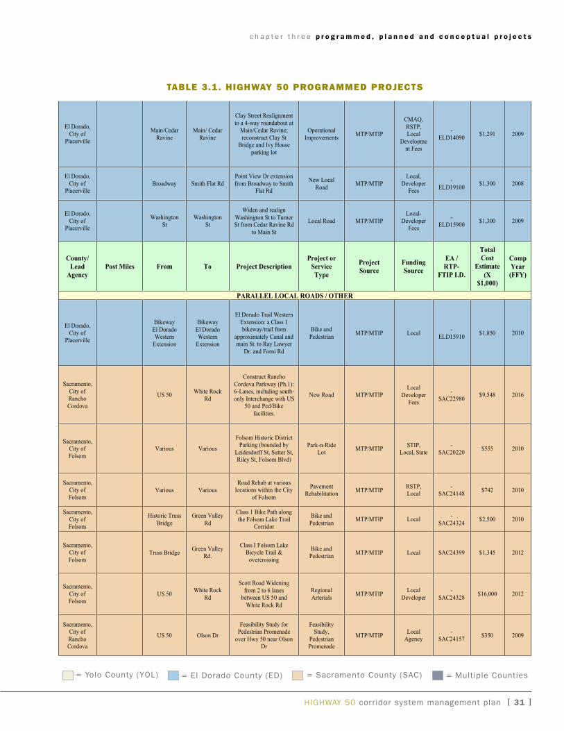
c h a p t e r t h r e e p r o g r a m m e d , p l a n n e d a n d c o n c e p t u a l p r o j e c t s
HigHway 50 corridor system management plan [ 3� ]
U.S. 50 Corridor System Management Plan
El Dorado,
City ofPlacerville
Main/Cedar
Ravine
Main/ Cedar
Ravine
Clay Street Realignment
to a 4-way roundabout atMain/Cedar Ravine;
reconstruct Clay StBridge and Ivy House
parking lot
Operational
ImprovementsMTP/MTIP
CMAQ,
RSTP,Local
Development Fees
-
ELD14090$1,291 2009
El Dorado,
City ofPlacerville
Broadway Smith Flat Rd
Point View Dr extension
from Broadway to SmithFlat Rd
New Local
RoadMTP/MTIP
Local,
DeveloperFees
-
ELD19100$1,300 2008
El Dorado,
City ofPlacerville
Washington
St
Washington
St
Widen and realign
Washington St to TurnerSt from Cedar Ravine Rd
to Main St
Local Road MTP/MTIP
Local-
DeveloperFees
-
ELD15900$1,300 2009
County/
Lead
Agency
Post Miles From To Project Description
Project or
Service
Type
Project
Source
Funding
Source
EA /
RTP-
FTIP I.D.
Total
Cost
Estimate
(X
$1,000)
Comp
Year
(FFY)
PARALLEL LOCAL ROADS / OTHER
El Dorado,
City ofPlacerville
Bikeway
El DoradoWestern
Extension
Bikeway
El DoradoWestern
Extension
El Dorado Trail Western
Extension: a Class 1bikeway/trail from
approximately Canal andmain St. to Ray Lawyer
Dr. and Forni Rd
Bike and
PedestrianMTP/MTIP Local
-
ELD15910$1,850 2010
Sacramento,
City ofRancho
Cordova
US 50White Rock
Rd
Construct Rancho
Cordova Parkway (Ph.1):6-Lanes, including south-
only Interchange with US50 and Ped/Bike
facilities.
New Road MTP/MTIPLocal
DeveloperFees
-
SAC22980$9,548 2016
Sacramento,City of
Folsom
Various Various
Folsom Historic DistrictParking (bounded by
Leidesdorff St, Sutter St,Riley St, Folsom Blvd)
Park-n-RideLot
MTP/MTIPSTIP,
Local, State-
SAC20220$555 2010
Sacramento,City of
FolsomVarious Various
Road Rehab at variouslocations within the City
of Folsom
PavementRehabilitation
MTP/MTIPRSTP,Local
-SAC24148
$742 2010
Sacramento,
City ofFolsom
Historic Truss
Bridge
Green Valley
Rd
Class 1 Bike Path along
the Folsom Lake TrailCorridor
Bike and
PedestrianMTP/MTIP Local
-
SAC24324$2,500 2010
Sacramento,City of
FolsomTruss Bridge
Green ValleyRd.
Class I Folsom LakeBicycle Trail &
overcrossing
Bike andPedestrian
MTP/MTIP Local SAC24399 $1,345 2012
Sacramento,
City ofFolsom
US 50White Rock
Rd
Scott Road Widening
from 2 to 6 lanesbetween US 50 and
White Rock Rd
Regional
ArterialsMTP/MTIP
Local
Developer
-
SAC24328$16,000 2012
Sacramento,City of
RanchoCordova
US 50 Olson Dr
Feasibility Study forPedestrian Promenade
over Hwy 50 near OlsonDr
FeasibilityStudy,
PedestrianPromenade
MTP/MTIPLocal
Agency-
SAC24157$350 2009
taBle 3.1. highway 50 prOgraMMed prOjects
= yolo County (yOL) = El Dorado County (ED) = Sacramento County (SaC) = Multiple Counties
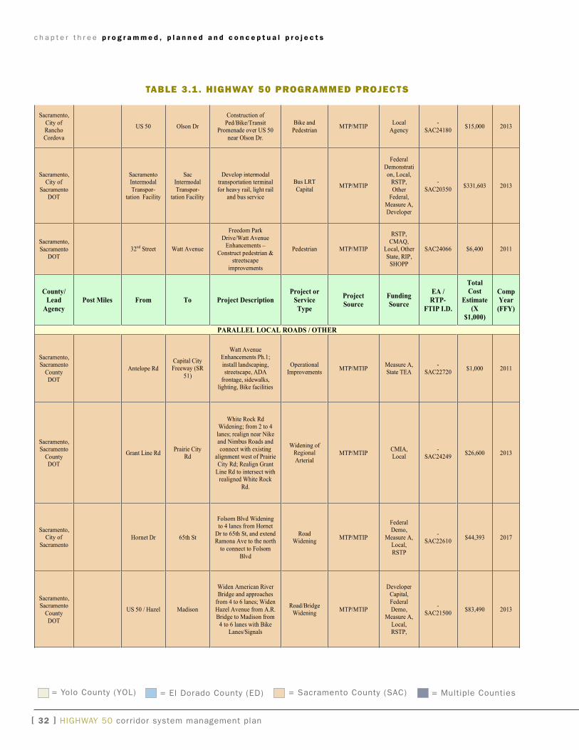
c h a p t e r t h r e e p r o g r a m m e d , p l a n n e d a n d c o n c e p t u a l p r o j e c t s
[ 32 ] HigHway 50 corridor system management plan
U.S. 50 Corridor System Management Plan
Sacramento,
City ofRancho
Cordova
US 50 Olson Dr
Construction of
Ped/Bike/TransitPromenade over US 50
near Olson Dr.
Bike and
PedestrianMTP/MTIP
Local
Agency
-
SAC24180$15,000 2013
Sacramento,City of
SacramentoDOT
SacramentoIntermodal
Transpor-tation Facility
SacIntermodal
Transpor-tation Facility
Develop intermodaltransportation terminal
for heavy rail, light railand bus service
Bus LRT
CapitalMTP/MTIP
Federal
Demonstrati
on, Local,RSTP,
OtherFederal,
Measure A,Developer
-
SAC20350$331,603 2013
Sacramento,
SacramentoDOT
32nd Street Watt Avenue
Freedom Park
Drive/Watt AvenueEnhancements –
Construct pedestrian &streetscape
improvements
Pedestrian MTP/MTIP
RSTP,
CMAQ,Local, Other
State, RIP,SHOPP
SAC24066 $6,400 2011
County/
Lead
Agency
Post Miles From To Project Description
Project or
Service
Type
Project
Source
Funding
Source
EA /
RTP-
FTIP I.D.
Total
Cost
Estimate
(X
$1,000)
Comp
Year
(FFY)
PARALLEL LOCAL ROADS / OTHER
Sacramento,Sacramento
CountyDOT
Antelope Rd
Capital CityFreeway (SR
51)
Watt AvenueEnhancements Ph.1;
install landscaping,streetscape, ADA
frontage, sidewalks,lighting, Bike facilities
OperationalImprovements
MTP/MTIPMeasure A,State TEA
-SAC22720
$1,000 2011
Sacramento,Sacramento
CountyDOT
Grant Line RdPrairie City
Rd
White Rock RdWidening; from 2 to 4
lanes; realign near Nikeand Nimbus Roads and
connect with existingalignment west of Prairie
City Rd; Realign Grant
Line Rd to intersect withrealigned White Rock
Rd.
Widening ofRegional
ArterialMTP/MTIP
CMIA,Local
-SAC24249
$26,600 2013
Sacramento,City of
SacramentoHornet Dr 65th St
Folsom Blvd Wideningto 4 lanes from Hornet
Dr to 65th St, and extendRamona Ave to the north
to connect to Folsom
Blvd
RoadWidening
MTP/MTIP
FederalDemo,
Measure A,Local,
RSTP
-SAC22610
$44,393 2017
Sacramento,Sacramento
County
DOT
US 50 / Hazel Madison
Widen American RiverBridge and approaches
from 4 to 6 lanes; Widen
Hazel Avenue from A.R.Bridge to Madison from
4 to 6 lanes with BikeLanes/Signals
Road/BridgeWidening
MTP/MTIP
DeveloperCapital,
Federal
Demo,Measure A,
Local,RSTP,
-SAC21500
$83,490 2013
taBle 3.1. highway 50 prOgraMMed prOjects
= yolo County (yOL) = El Dorado County (ED) = Sacramento County (SaC) = Multiple Counties
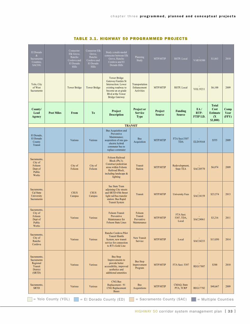
c h a p t e r t h r e e p r o g r a m m e d , p l a n n e d a n d c o n c e p t u a l p r o j e c t s
HigHway 50 corridor system management plan [ 33 ]
El Dorado
&Sacramento
Counties,SACOG
Connector:
Elk Grove,Rancho
Cordova andEl Dorado
Hills
Connector Elk
Grove,Rancho
Cordova andEl Dorado
Hills
Study a multi-modal
connector between ElkGrove, Rancho
Cordova and ElDorado Hills
Planning
StudyMTP/MTIP RSTP, Local
-
VAR10300$1,863 2010
Yolo, City
of WestSacramento
Tower Bridge Tower Bridge
Tower Bridge
Gateway/Garden StIntersection: Lower
existing roadway tobecome an at-grade
Blvd at the TowerBridge Gateway
Transportation
EnhancementActivities
MTP/MTIP RSTP, Local-
YOL19211$6,100 2009
County/
Lead
Agency
Post Miles From ToProject
Description
Project or
Service
Type
Project
Source
Funding
Source
EA /
RTP-
FTIP I.D.
Total
Cost
Estimate
(X
$1,000)
Comp
Year
(FFY)
TRANSIT
El Dorado,El Dorado
CountyTransit
Various Various
Bus Acquisition andPreventive
Maintenance;acquisition of one gas-
electric hybridcommuter bus to
replace commuter
BusAcquisition
MTP/MTIPFTA Sect.5307
TDA-
ELD19164$555 2009
Sacramento,
City ofFolsom
Dept ofPublic
Works
City of
Folsom
City of
Folsom
Folsom Railroad
Block (Ph.3);Construct pedestrian
areas within FolsomRailroad Block,
including landscape &lighting
Transit
StationMTP/MTIP
Redevelopment,
State TEA
-
SAC20570$6,074 2009
Sacramento,
Cal StateUniversity
Sacramento
CSUS
Campus
CSUS
Campus
Sac State Tram
adjoining City streetsand SRTD 65th Street
light rail/bus transferstation: Bus Rapid
Transit System
Transit MTP/MTIP University Fees-
SAC24159$23,574 2013
Sacramento,City of
FolsomDept of
Public
Works
Various Various
Folsom TransitPreventive
Maintenance forFolsom State Lines
FolsomTransit
PreventiveMaintenance
MTP/MTIPFTA Sect.
5307, TDA,
Local
-SAC24061
$3,216 2011
Sacramento,City of
Rancho
Cordova
Various Various
Rancho Cordova PilotTransit Shuttle
System; new transit
service for connectionto RT's Gold Line
New TransitService
MTP/MTIP Local-
SAC24233$13,050 2014
Sacramento,
SacramentoRegional
TransitDistrict
(SRTD)
Various Various
Bus Stop
Improvements toprovide better
accessibility, improvedaesthetics and
additional amenities
Bus Stop
ImprovementProgram
MTP/MTIP FTA Sect. 5307-
REG17807$388 2010
Sacramento,
SRTDVarious Various
CNG Bus
Replacement - 91CNG Replacement
Buses
Bus
AcquisitionsMTP/MTIP
CMAQ, State
PTA, TCRP
-
REG17782$40,667 2009
taBle 3.1. highway 50 prOgraMMed prOjects
= yolo County (yOL) = El Dorado County (ED) = Sacramento County (SaC) = Multiple Counties
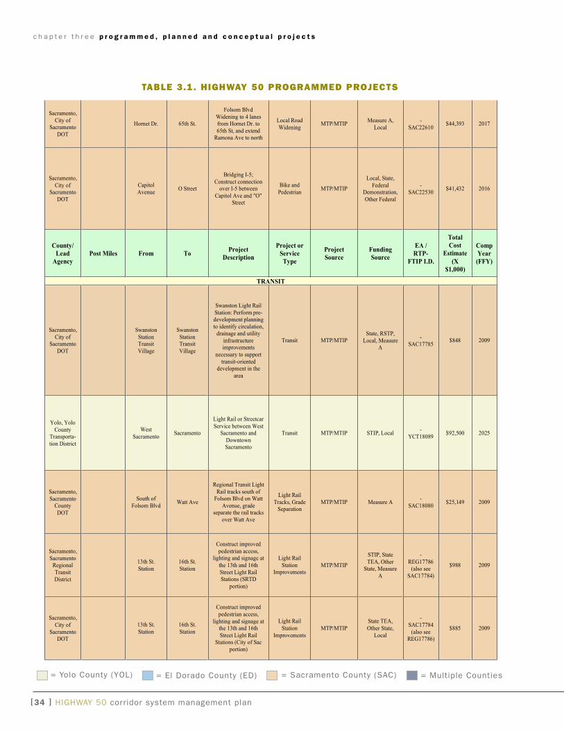
c h a p t e r t h r e e p r o g r a m m e d , p l a n n e d a n d c o n c e p t u a l p r o j e c t s
[3� ] HigHway 50 corridor system management plan
Sacramento,
City ofSacramento
DOT
Hornet Dr. 65th St.
Folsom Blvd
Widening to 4 lanesfrom Hornet Dr. to
65th St, and extendRamona Ave to north
Local Road
WideningMTP/MTIP
Measure A,
Local
-
SAC22610$44,393 2017
Sacramento,
City ofSacramento
DOT
Capitol
AvenueO Street
Bridging I-5;
Construct connectionover I-5 between
Capitol Ave and "O"Street
Bike and
PedestrianMTP/MTIP
Local, State,
FederalDemonstration,
Other Federal
-
SAC22530$41,432 2016
County/
Lead
Agency
Post Miles From ToProject
Description
Project or
Service
Type
Project
Source
Funding
Source
EA /
RTP-
FTIP I.D.
Total
Cost
Estimate
(X
$1,000)
Comp
Year
(FFY)
TRANSIT
Sacramento,
City ofSacramento
DOT
Swanston
StationTransit
Village
Swanston
StationTransit
Village
Swanston Light Rail
Station: Perform pre-development planning
to identify circulation,drainage and utility
infrastructureimprovements
necessary to support
transit-orienteddevelopment in the
area
Transit MTP/MTIPState, RSTP,
Local, MeasureA
-
SAC17785$848 2009
Yolo, Yolo
CountyTransporta-
tion District
West
SacramentoSacramento
Light Rail or Streetcar
Service between WestSacramento and
DowntownSacramento
Transit MTP/MTIP STIP, Local-
YCT18089$92,500 2025
Sacramento,
SacramentoCounty
DOT
South of
Folsom BlvdWatt Ave
Regional Transit Light
Rail tracks south ofFolsom Blvd on Watt
Avenue, gradeseparate the rail tracks
over Watt Ave
Light Rail
Tracks, GradeSeparation
MTP/MTIP Measure A-
SAC18080$25,149 2009
Sacramento,
SacramentoRegional
Transit
District
13th St.
Station
16th St.
Station
Construct improved
pedestrian access,lighting and signage at
the 13th and 16th
Street Light RailStations (SRTD
portion)
Light Rail
StationImprovements
MTP/MTIP
STIP, State
TEA, OtherState, Measure
A
-
REG17786(also see
SAC17784)
$988 2009
Sacramento,
City of
SacramentoDOT
13th St.
Station
16th St.
Station
Construct improved
pedestrian access,
lighting and signage atthe 13th and 16th
Street Light RailStations (City of Sac
portion)
Light Rail
Station
Improvements
MTP/MTIP
State TEA,
Other State,
Local
-
SAC17784
(also seeREG17786)
$885 2009
taBle 3.1. highway 50 prOgraMMed prOjects
= yolo County (yOL) = El Dorado County (ED) = Sacramento County (SaC) = Multiple Counties
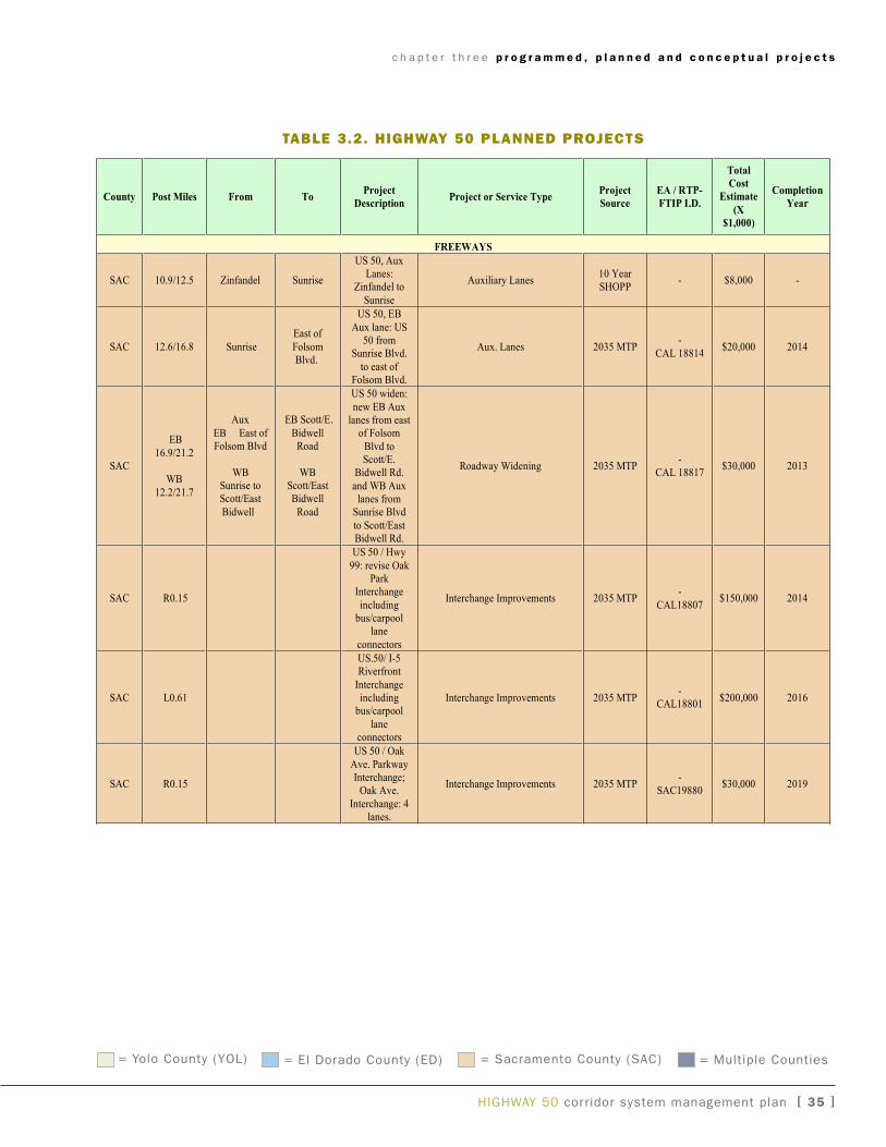
c h a p t e r t h r e e p r o g r a m m e d , p l a n n e d a n d c o n c e p t u a l p r o j e c t s
HigHway 50 corridor system management plan [ 35 ]
U.S. 50 Corridor System Management Plan
Page 17
3.2 Planned Projects
“Planned” improvements are those projects included in the applicable metropolitan orregional transportation plans (MTP or RTP), or the 2007 Ten-Year State HighwaysOperation and Protection Program (SHOPP) Plan.
Table 3.2 Planned Projects
County Post Miles From ToProject
DescriptionProject or Service Type
Project
Source
EA / RTP-
FTIP I.D.
Total
Cost
Estimate
(X
$1,000)
Completion
Year
FREEWAYS
SAC 10.9/12.5 Zinfandel Sunrise
US 50, AuxLanes:
Zinfandel to
Sunrise
Auxiliary Lanes10 YearSHOPP
- $8,000 -
SAC 12.6/16.8 Sunrise
East of
FolsomBlvd.
US 50, EB
Aux lane: US50 from
Sunrise Blvd.
to east ofFolsom Blvd.
Aux. Lanes 2035 MTP-
CAL 18814$20,000 2014
SAC
EB
16.9/21.2
WB
12.2/21.7
Aux
EB East ofFolsom Blvd
WBSunrise toScott/East
Bidwell
EB Scott/E.
BidwellRoad
WBScott/EastBidwell
Road
US 50 widen:
new EB Auxlanes from east
of Folsom
Blvd toScott/E.
Bidwell Rd.
and WB Auxlanes from
Sunrise Blvd
to Scott/EastBidwell Rd.
Roadway Widening 2035 MTP-
CAL 18817$30,000 2013
SAC R0.15
US 50 / Hwy
99: revise OakPark
Interchange
includingbus/carpool
lane
connectors
Interchange Improvements 2035 MTP-
CAL18807$150,000 2014
SAC L0.61
US.50/ I-5Riverfront
Interchangeincludingbus/carpool
laneconnectors
Interchange Improvements 2035 MTP-
CAL18801$200,000 2016
SAC R0.15
US 50 / Oak
Ave. ParkwayInterchange;
Oak Ave.
Interchange: 4lanes.
Interchange Improvements 2035 MTP-
SAC19880$30,000 2019
taBle 3.2. highway 50 planned prOjects
= yolo County (yOL) = El Dorado County (ED) = Sacramento County (SaC) = Multiple Counties
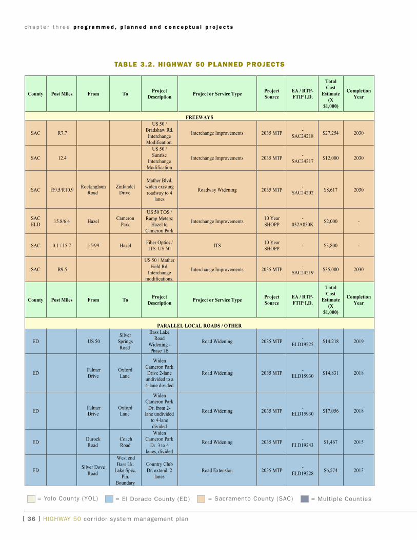
c h a p t e r t h r e e p r o g r a m m e d , p l a n n e d a n d c o n c e p t u a l p r o j e c t s
[ 3� ] HigHway 50 corridor system management plan
U.S. 50 Corridor System Management Plan
County Post Miles From ToProject
DescriptionProject or Service Type
Project
Source
EA / RTP-
FTIP I.D.
Total
Cost
Estimate
(X
$1,000)
Completion
Year
FREEWAYS
SAC R7.7
US 50 /Bradshaw Rd.
InterchangeModification.
Interchange Improvements 2035 MTP-
SAC24218$27,254 2030
SAC 12.4
US 50 /
SunriseInterchangeModification
Interchange Improvements 2035 MTP-
SAC24217$12,000 2030
SAC R9.5/R10.9Rockingham
RoadZinfandel
Drive
Mather Blvd,widen existing
roadway to 4lanes
Roadway Widening 2035 MTP-
SAC24202$8,617 2030
SAC
ELD15.8/6.4 Hazel
Cameron
Park
US 50 TOS /
Ramp Meters:Hazel to
Cameron Park
Interchange Improvements10 Year
SHOPP
-
032A850K$2,000 -
SAC 0.1 / 15.7 I-5/99 HazelFiber Optics /ITS: US 50
ITS10 YearSHOPP
- $3,800 -
SAC R9.5
US 50 / Mather
Field Rd.Interchange
modifications.
Interchange Improvements 2035 MTP-
SAC24219$35,000 2030
County Post Miles From ToProject
DescriptionProject or Service Type
Project
Source
EA / RTP-
FTIP I.D.
Total
Cost
Estimate
(X
$1,000)
Completion
Year
PARALLEL LOCAL ROADS / OTHER
ED US 50Silver
Springs
Road
Bass LakeRoad
Widening -Phase 1B
Road Widening 2035 MTP-
ELD19225$14,218 2019
EDPalmer
Drive
Oxford
Lane
Widen
Cameron ParkDrive 2-lane
undivided to a
4-lane divided
Road Widening 2035 MTP-
ELD15930$14,831 2018
EDPalmerDrive
OxfordLane
WidenCameron Park
Dr. from 2-lane undivided
to 4-lane
divided
Road Widening 2035 MTP-
ELD15930$17,056 2018
EDDurockRoad
CoachRoad
WidenCameron Park
Dr. 3 to 4lanes, divided
Road Widening 2035 MTP-
ELD19243$1,467 2015
EDSilver Dove
Road
West end
Bass Lk.Lake Spec.
Pln.
Boundary
Country Club
Dr. extend, 2lanes
Road Extension 2035 MTP-
ELD19228$6,574 2013
taBle 3.2. highway 50 planned prOjects
= yolo County (yOL) = El Dorado County (ED) = Sacramento County (SaC) = Multiple Counties
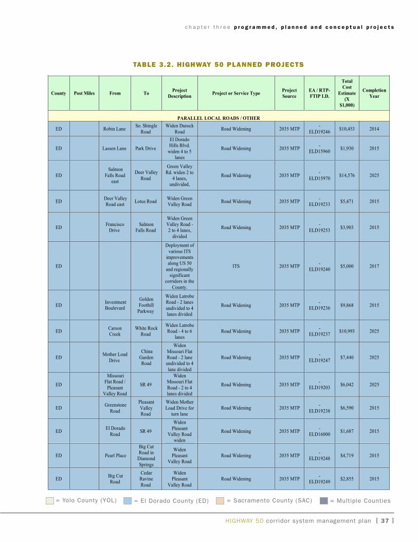
c h a p t e r t h r e e p r o g r a m m e d , p l a n n e d a n d c o n c e p t u a l p r o j e c t s
HigHway 50 corridor system management plan [ 3� ]
County Post Miles From ToProject
DescriptionProject or Service Type
Project
Source
EA / RTP-
FTIP I.D.
Total
Cost
Estimate
(X
$1,000)
Completion
Year
PARALLEL LOCAL ROADS / OTHER
ED Robin LaneSo. Shingle
Road
Widen Durock
RoadRoad Widening 2035 MTP
-
ELD19246$10,453 2014
ED Lassen Lane Park Drive
El DoradoHills Blvd.
widen 4 to 5lanes
Road Widening 2035 MTP-
ELD15960$1,930 2015
ED
Salmon
Falls Roadeast
Deer Valley
Road
Green Valley
Rd. widen 2 to4 lanes,
undivided,
Road Widening 2035 MTP-
ELD15970$14,576 2025
EDDeer ValleyRoad east
Lotus RoadWiden GreenValley Road
Road Widening 2035 MTP-
ELD19233$5,471 2015
EDFrancisco
DriveSalmon
Falls Road
Widen GreenValley Road -2 to 4 lanes,
divided
Road Widening 2035 MTP-
ELD19253$3,903 2015
ED
Deployment of
various ITSimprovementsalong US 50
and regionallysignificant
corridors in the
County.
ITS 2035 MTP-
ELD19240$5,000 2017
EDInvestmentBoulevard
GoldenFoothill
Parkway
Widen LatrobeRoad - 2 lanes
undivided to 4lanes divided
Road Widening 2035 MTP-
ELD19236$9,868 2015
EDCarsonCreek
White RockRoad
Widen LatrobeRoad - 4 to 6
lanesRoad Widening 2035 MTP
-ELD19237
$10,993 2025
EDMother Load
Drive
China
GardenRoad
Widen
Missouri FlatRoad - 2 laneundivided to 4
lane divided
Road Widening 2035 MTP-
ELD19247$7,440 2025
ED
MissouriFlat Road /
PleasantValley Road
SR 49
WidenMissouri Flat
Road - 2 to 4lanes divided
Road Widening 2035 MTP-
ELD19203$6,042 2025
EDGreenstone
Road
Pleasant
ValleyRoad
Widen Mother
Load Drive forturn lane
Road Widening 2035 MTP-
ELD19238$6,590 2015
EDEl Dorado
RoadSR 49
Widen
PleasantValley Road
widen
Road Widening 2035 MTP-
ELD16000$1,687 2015
ED Pearl Place
Big CutRoad in
Diamond
Springs
WidenPleasant
Valley RoadRoad Widening 2035 MTP
-ELD19248
$4,719 2015
EDBig CutRoad
CedarRavine
Road
WidenPleasant
Valley Road
Road Widening 2035 MTP-
ELD19249$2,855 2015
taBle 3.2. highway 50 planned prOjects
= yolo County (yOL) = El Dorado County (ED) = Sacramento County (SaC) = Multiple Counties
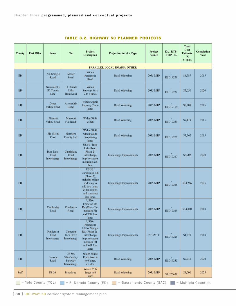
c h a p t e r t h r e e p r o g r a m m e d , p l a n n e d a n d c o n c e p t u a l p r o j e c t s
[ 3� ] HigHway 50 corridor system management plan
U.S. 50 Corridor System Management Plan
County Post Miles From ToProject
DescriptionProject or Service Type
Project
Source
EA / RTP-
FTIP I.D.
Total
Cost
Estimate
(X
$1,000)
Completion
Year
PARALLEL LOCAL ROADS / OTHER
EDNo. Shingle
Road
Meder
Road
Widen
PonderosaRoad
Road Widening 2035 MTP-
ELD19250$4,787 2015
ED
Sacramento/ED County
Line
El DoradoHills
Boulevard
WidenSaratoga Way
2 to 4 lanesRoad Widening 2035 MTP
-ELD19234
$5,050 2020
EDGreen
Valley Road
Alexandria
Road
Widen SophiaParkway 2 to 4
lanes
Road Widening 2035 MTP-
ELD19179$5,208 2015
EDPleasant
Valley Road
Missouri
Flat Road
Widen SR49
widenRoad Widening 2035 MTP
-
ELD19251$9,419 2015
EDSR 193 in
Cool
Northern
County line
Widen SR49
widen to addtwo passing
lanes
Road Widening 2035 MTP-
ELD19252$3,762 2015
EDBass Lake
Road
Interchange
CambridgeRoad
Interchange
US 50 / BassLake Road
Phase 2-interchange
improvements
including aux.lane
Interchange Improvements 2035 MTP-
ELD19217$6,902 2020
ED
US 50 /
Cambridge Rd.(Phase 2),
includes bridge
widening toadd two lanes,widen ramps,
and constructaux lanes
Interchange Improvements 2035 MTP-
ELD19218$14,286 2025
EDCambridge
Road
Ponderosa
Road
US50 /
Cameron Pk.Dr. (Phase 2) -
includes EB
and WB Aux.lanes
Interchange Improvements 2035 MTP-
ELD19219$14,000 2018
EDPonderosa
RoadInterchange
CameronPark Drive
Interchange
US50 /Ponderosa
Rd/So. Shingle
Rd. (Phase 2) -interchange
improvements
includes EBand WB Aux
lanes
Interchange Improvements 2035MTP-
ELD19220$4,270 2018
EDLatrobeRoad
US 50 /Silva Valley
Parkway
Interchange
Widen WhiteRock Road 4
to 6 lanes,
divided
Road Widening 2035 MTP-
ELD19235$9,230 2020
SAC US 50 BroadwayWiden 65th
Street to 6lanes
Road Widening 2035 MTP-
SAC23630$4,000 2025
taBle 3.2. highway 50 planned prOjects
= yolo County (yOL) = El Dorado County (ED) = Sacramento County (SaC) = Multiple Counties
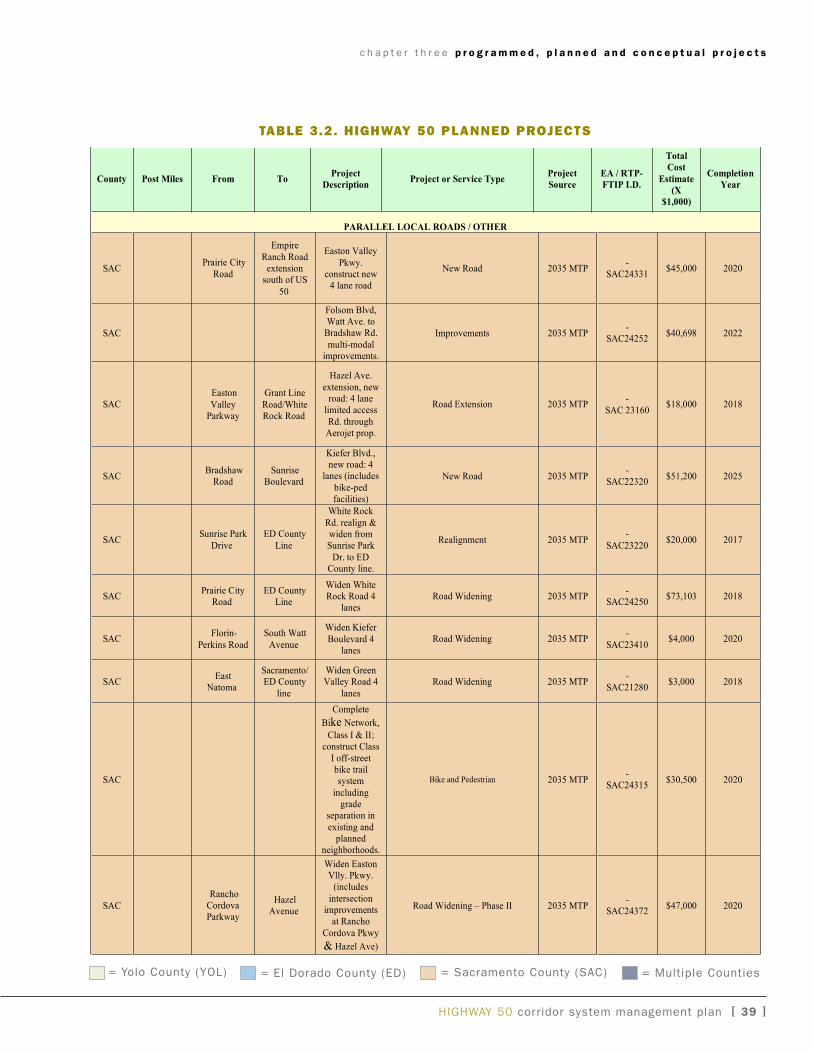
c h a p t e r t h r e e p r o g r a m m e d , p l a n n e d a n d c o n c e p t u a l p r o j e c t s
HigHway 50 corridor system management plan [ 3� ]
U.S. 50 Corridor System Management Plan
County Post Miles From ToProject
DescriptionProject or Service Type
Project
Source
EA / RTP-
FTIP I.D.
Total
Cost
Estimate
(X
$1,000)
Completion
Year
PARALLEL LOCAL ROADS / OTHER
SACPrairie City
Road
Empire
Ranch Roadextension
south of US
50
Easton Valley
Pkwy.construct new
4 lane road
New Road 2035 MTP-
SAC24331$45,000 2020
SAC
Folsom Blvd,Watt Ave. to
Bradshaw Rd.
multi-modalimprovements.
Improvements 2035 MTP-
SAC24252$40,698 2022
SACEaston
ValleyParkway
Grant Line
Road/WhiteRock Road
Hazel Ave.
extension, newroad: 4 lane
limited access
Rd. throughAerojet prop.
Road Extension 2035 MTP-
SAC 23160$18,000 2018
SACBradshaw
RoadSunrise
Boulevard
Kiefer Blvd.,new road: 4
lanes (includes
bike-pedfacilities)
New Road 2035 MTP-
SAC22320$51,200 2025
SACSunrise Park
Drive
ED County
Line
White Rock
Rd. realign &widen fromSunrise Park
Dr. to EDCounty line.
Realignment 2035 MTP-
SAC23220$20,000 2017
SACPrairie City
RoadED County
Line
Widen WhiteRock Road 4
lanesRoad Widening 2035 MTP
-SAC24250
$73,103 2018
SACFlorin-
Perkins Road
South Watt
Avenue
Widen Kiefer
Boulevard 4lanes
Road Widening 2035 MTP-
SAC23410$4,000 2020
SACEast
Natoma
Sacramento/ED County
line
Widen GreenValley Road 4
lanes
Road Widening 2035 MTP-
SAC21280$3,000 2018
SAC
Complete
Bike Network,
Class I & II;construct Class
I off-streetbike trailsystem
includinggrade
separation in
existing andplanned
neighborhoods.
Bike and Pedestrian 2035 MTP-
SAC24315$30,500 2020
SAC
RanchoCordovaParkway
HazelAvenue
Widen EastonVlly. Pkwy.
(includes
intersectionimprovements
at Rancho
Cordova Pkwy
& Hazel Ave)
Road Widening – Phase II 2035 MTP-
SAC24372$47,000 2020
taBle 3.2. highway 50 planned prOjects
= yolo County (yOL) = El Dorado County (ED) = Sacramento County (SaC) = Multiple Counties
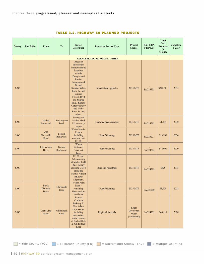
c h a p t e r t h r e e p r o g r a m m e d , p l a n n e d a n d c o n c e p t u a l p r o j e c t s
[ �0 ] HigHway 50 corridor system management plan
U.S. 50 Corridor System Management Plan
County Post Miles From ToProject
DescriptionProject or Service Type
Project
Source
EA / RTP-
FTIP I.D.
Total
Cost
Estimate
(X
$1,000)
Completio
n Year
PARALLEL LOCAL ROADS / OTHER
SAC
At grade
intersectionimprovements:
locations
include:Douglas and
Sunrise,
InternationalDr. and
Sunrise, White
Rock Rd. andSunrise,
Folsom Blvdand Sunrise
Blvd., RanchoCordova Pkwy
and White
Rock Rd. andothers
Intersection Upgrades 2035 MTP-
SAC24335$242,301 2035
SACMather
BoulevardRockingham
Road
ReconstructMather FieldRd. two-way
couplet
Roadway Reconstruction 2035 MTP-
SAC24203$1,884 2030
SAC
OldPlacerville
Road
FolsomBoulevard
Widen RoutierRoad -
includingstructure over
US 50.
Road Widening 2035 MTP-
SAC24221$13,706 2030
SACInternational
DriveFolsom
Boulevard
WidenZinfandelDrive to 6
lanes
Road Widening 2035 MTP-
SAC24214$12,000 2020
SAC
US 50 ped./bike crossing
at Mather FieldRd.: facility
crossing US 50
along theMather Airport
RR Spur
alignment.
Bike and Pedestrian 2035 MTP-
SAC24299$820 2015
SAC
BlackDiamond
Drive
ClarksvilleRoad
Widen PointRoad -
remaining4lane sections
to 6 lanes
Road Widening 2035 MTP-
SAC21210$5,000 2018
SACGrant Line
RoadWhite Rock
Road
RanchoCordova
Parkway II:New 6-laneexpressway,
includingintersection
improvements
at Kiefer Blvd.& White Rock
Road
Regional Arterials
LocalDeveloper,
Other(Undefined)
SAC24295 $44,518 2020
taBle 3.2. highway 50 planned prOjects
= yolo County (yOL) = El Dorado County (ED) = Sacramento County (SaC) = Multiple Counties
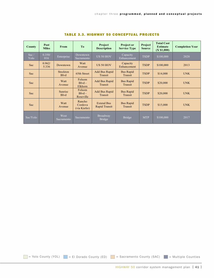
c h a p t e r t h r e e p r o g r a m m e d , p l a n n e d a n d c o n c e p t u a l p r o j e c t s
HigHway 50 corridor system management plan [ �� ]
U.S. 50 Corridor System Management Plan
3.3 Conceptual Projects
“Conceptual” improvements are those projects included in a planning document otherthan a MTP, RTP, or the Ten-Year SHOPP. Note: TSDP = Transportation SystemDevelopment Program
Table 3.3 Conceptual Projects
CountyPost
MilesFrom To
Project
Description
Project or
Service Type
Project
Source
Total Cost
Estimate
(X $1,000)
Completion Year
Sac /Yolo
0.350/016
EnterpriseDowntownSacramento
US 50 HOVCapacity
EnhancementTSDP $100,000 2020
Sac0.962/5.336
DowntownWatt
AvenueUS 50 HOV
CapacityEnhancement
TSDP $100,000 2013
SacStocktonBlvd
65th StreetAdd Bus Rapid
TransitBus Rapid
TransitTSDP $14,000 UNK
SacWatt
Avenue
Folsom
Blvd -Elkhorn
Add Bus Rapid
Transit
Bus Rapid
TransitTSDP $20,000 UNK
SacSunriseBlvd
FolsomBlvd -Roseville
Add Bus RapidTransit
Bus RapidTransit
TSDP $20,000 UNK
SacWatt
Avenue
RanchoCordova(via Kiefer)
Extend BusRapid Transit
Bus RapidTransit
TSDP $15,000 UNK
Sac/YoloWest
SacramentoSacramento
Broadway
BridgeBridge MTP $100,000 2017
taBle 3.3. highway 50 cOnceptual prOjects
= yolo County (yOL) = El Dorado County (ED) = Sacramento County (SaC) = Multiple Counties