Embed Size (px)
Citation preview

Working with Census OperationsCase Study from KSA
International Workshop on Integrating Geospatial and Statistical Information
Abdullah M.AlhamlanKingdom of Saudi Arabia
Central Department of Statistics & InformationHead of Mapping [email protected]
http://www.cdsi.gov.sa
Beijing 9‐12 June 2014

The Kingdom of Saudi Arabia lies at thefurthermost part of southwestern Asia. It isbordered to the west by the Red Sea, to theeast by the Arabian Gulf, United ArabEmirates and Qatar, to the north by Kuwait,Iraq and Jordan, and to the south by Yemenand Oman. The Kingdom lies between 16 2246 and 32 14 00 North, and 34 29 30 and 5540 00 East.
The Kingdom of Saudi Arabia occupiesabout four‐fifths of the Arab Peninsula,with a total area of around 2,000,000square kilometers.
The Kingdom of Saudi Arabia is divided into13 regions. In addition to the headquartersof the region (emirate), each region isdivided into a number of governorates.
Kingdom of Saudi Arabia

Sector of statistics and information in the Kingdom of Saudi Arabia consists of the Central Department ofStatistics and Information (Central Agency for Statistics) and multi Suit of statistical centers and units formedwithin the administrative structures of government agencies and some private sector institutions under atechnical supervision done by the Central Department of Statistics and Information (CDSI).
CDSI draws out its statistical information from two main sources representing the core of national statisticssystem, namely:
1. General statistics of censuses, field surveys, research and statistical studies conducted by the CDSI.
2. Administrative records (administrative data) derived from the records, bulletins and statistical reports issuedby the statistical units and information centers in government agencies and institutions in its capacity asresponsible for providing the service concerned.
Central Department of Statistics & Information

CDSI Objective
Improving , enhancing and facilitating the Process of
Census Operationto deliver not
only data but alsoKnowledge
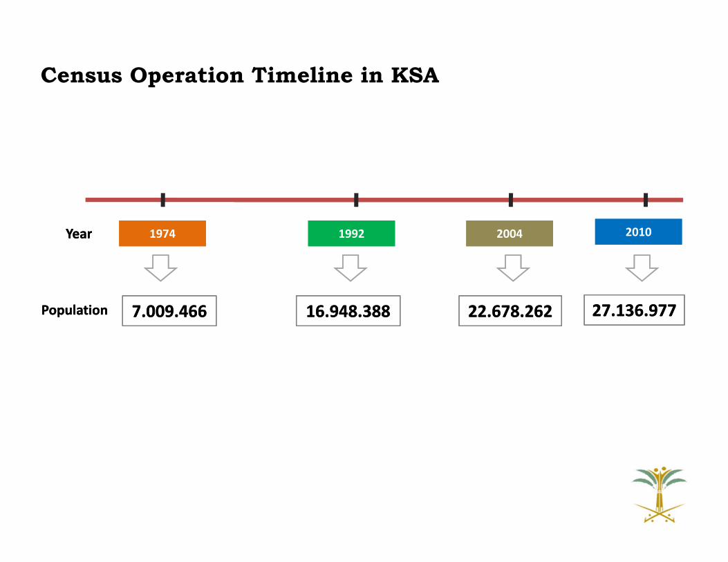
Census Operation Timeline in KSA
19741974 19921992 20042004 20102010
7.009.4667.009.466 16.948.38816.948.388 22.678.26222.678.262 27.136.97727.136.977
YearYear
PopulationPopulation

Population Census is defined as the entireoperation of collecting demographic,economic and social data with reference topopulation in a specific period of time. Itincludes the counting of every individualalive inside the borders of a specific countryat a particular point in time. It also meansthe registration of the individual's social andeconomic characteristics at that point intime. These characteristics are recorded forevery member of the family.
Population Census is defined as the entireoperation of collecting demographic,economic and social data with reference topopulation in a specific period of time. Itincludes the counting of every individualalive inside the borders of a specific countryat a particular point in time. It also meansthe registration of the individual's social andeconomic characteristics at that point intime. These characteristics are recorded forevery member of the family.
1 ‐ Provide the state, planners andresearchers with the basic data onpopulation and housing necessary fordevelopment planning.
2 ‐ Set up an up‐to‐date frame for allspecialized statistical research beingundertaken in accordance with the samplemethod such as research related to: laborforce, consumption expenditures, fertility,mortality, migration and environment,housing features, etc.
3 ‐ Set up a wide database to help inundertaking various demographic studiesrequired for social and economic planning.
4 ‐ Periodically make available data andindices required to measure the change indemographic profile, make comparisonsand make future projections.
All persons inside the Saudi borders(whether Saudis or non Saudis) arecovered by the census operation whetherthose persons are staying permanently ortemporarily in the Kingdom.
The census includes the followingcategories as well:
1‐ Saudi diplomats living abroad. Thecounting of those diplomats isundertaken in coordination with theMinistry of Foreign Affairs.
2 ‐ Other Saudis living abroad for variousreasons (such as business, tourism,medical treatments, etc.)
WHAT WHY WHERE
Understanding Census Operation

The Roles of CDSI-Mapping Unit in Census Operation
Production and preparing maps for census operation and statistical tasks in KSA
Analyze and normalize data for better understanding of
the census results
Build the base‐map for census operation to be available in and out CDSI
Build CDSI spatial database repository (multi–layer)
Building capacity of field surveyors and researchers
Disseminate the census results (Geo‐Distribution) for experts and public
(Atlases – Portal – Reports)

Preparing the Census OperationPre-Phase

9
Spatial Data Collection and Manipulation
Spatial Data Collection and Manipulation
Field MapsField Maps
Supervisors Maps+327
Supervisors Maps+327
Inspectors Maps+1390
Inspectors Maps+1390
Observers Maps+7300
Observers Maps+7300
GPS DataGPS Data
Settlements Numbering
Maps
Settlements Numbering
Maps
City Numbering Maps
City Numbering Maps
Detailed Maps (District Level)
+6500
Detailed Maps (District Level)
+6500
Detailed Maps(City Level)
+430
Detailed Maps(City Level)
+430
Regions Maps+13
Regions Maps+13
Governorates Maps+118
Governorates Maps+118
Collecting Updated Maps from local
Authorities
Collecting Updated Maps from local
Authorities
Build CDSI Spatial Database RepositoryBuild CDSI Spatial
Database Repository
Post ‐CensusPost ‐Census
Working with ResultsWorking with ResultsUpdating ProcessUpdating Process
Census AtlasPreliminary Results
Census AtlasPreliminary Results
CDSI Web Mapping Portal
CDSI Web Mapping Portal
Census AtlasDetailed ResultsCensus Atlas
Detailed Results
Using Maps in Census Operation
Pre‐CensusPre‐Census
More Than
16000Pre‐Census Field
Work Maps
Production of Maps for Census OperationProduction of Maps for Census Operation

Types of Maps in Census Operation
Settlements Maps
Regions Level
Governorates Level
Inspectors LevelInspectors Level
Observers LevelObservers Level
City Maps
City Level
Districts Level
Inspectors LevelInspectors Level
Observers LevelObservers Level

Producing Maps for Census
Operation
Producing (City – District –
Sector) Maps Producing Inspector or
Markup Map for any Selected
City
Producing Settlement Maps for any selected
governorate or region
CDSI-Mapping System

Pro
du
cti
on
of
Cit
ies
Ma
ps
District Boundaries
Sector Boundaries
Block Number
City NameNo of Districts
City IDNO of Sections
City MapsDistrict Map

SUPE
RVISOR 12
11
INSPECTOR 11
11
INSPECTOR 11
13
INSPECTOR 13
12
INSPECTOR 12
12
INSPECTOR 12
14
INSPECTOR 14
14
INSPECTOR 14
15
INSPECTOR 15
15
INSPECTOR 15
Supervisor Map City Maps

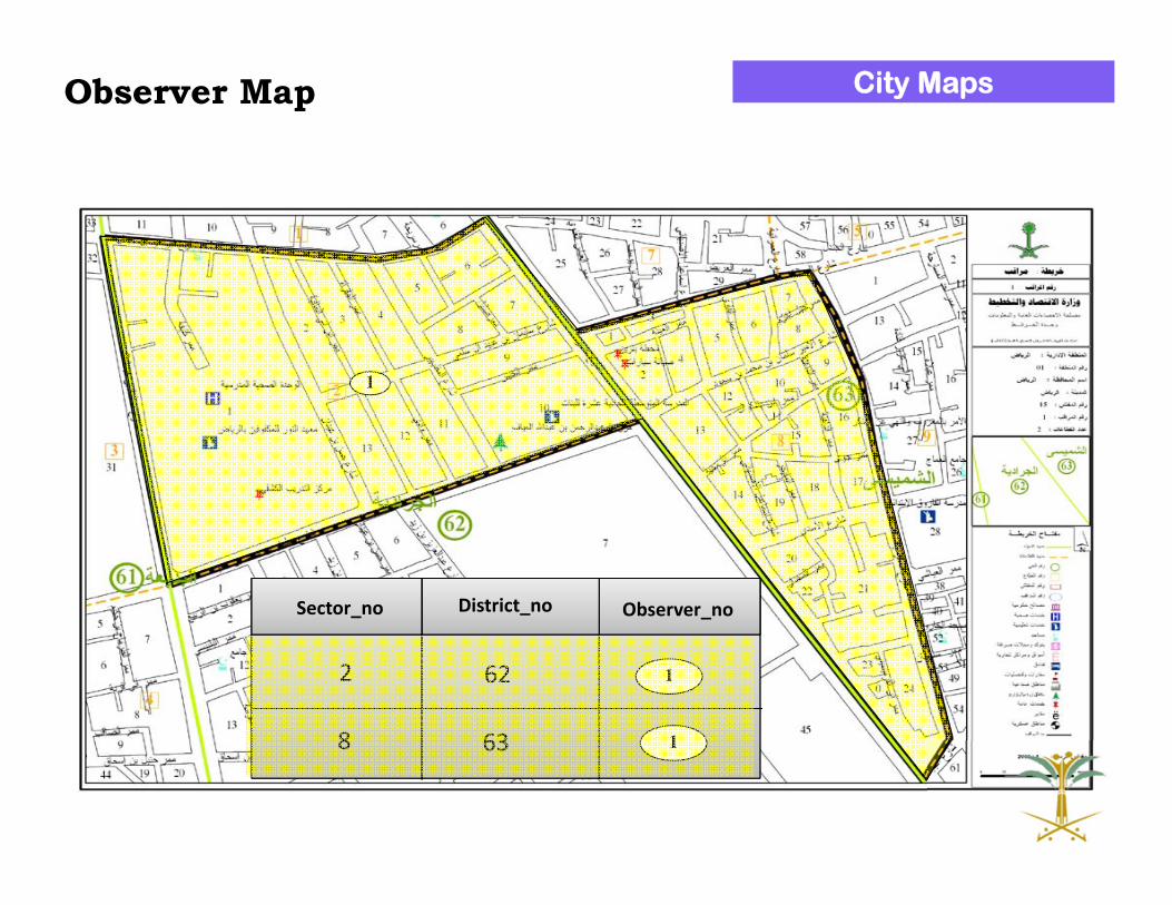
63
62263862313910624625626
ObserverDistrict_noSector_no
1
12
3
34
5
1
2
3
5
4
INSPECTOR 15
Each Observer has a Different Color
Inspector Map City Maps
1
Observer_noDistrict_noSector_no
1
1638
622
Observer Map City Maps

Pro
du
cti
on
of
Se
ttle
me
nts
Ma
ps
Region boundaries
Settlements
Governorate boundaries
Region Map
Classification of settlements
No of settlements in the governorate
Governorate boundaries
Settlements Classification of settlements
No of settlements in the governorate
Governorate boundaries
Settlements
Governorate Map
Observer Map Inspector Map
Inspector ID
Number of Settlements
Observer 1
Observer 2Observer ID
Number of Settlements
Observer 1
Observer X

Working with ResultsPost-Phase
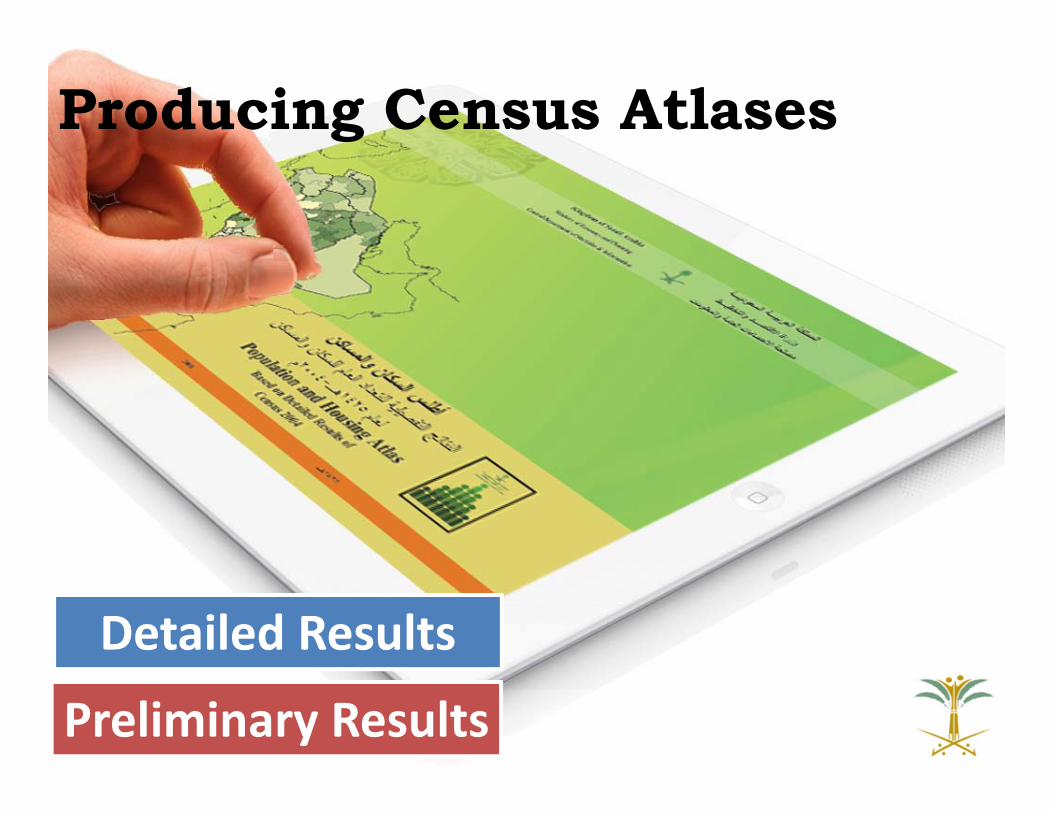
Producing Census Atlases
Preliminary Results
Detailed Results

Census Atlas ‐ Preliminary Results (Level 1)
Census Atlas ‐ Preliminary Results (Level 1)
Housing DistributionHousing Distribution Population distributionsPopulation distributions Administrative divisionsAdministrative divisions
KSA RegionsKSA Regions
KSA GovernoratesKSA Governorates
Population distribution by Regions
Population distribution by Regions
Population distribution by cities
Population distribution by cities
Population distribution by Governorates
Population distribution by Governorates
Population Distribution by governorates of each regionPopulation Distribution by governorates of each region
Houses distribution by RegionsHouses distribution by Regions
Houses distribution by citiesHouses distribution by cities
Houses distribution by Governorates
Houses distribution by Governorates
Houses Distribution by governorates of each region
Houses Distribution by governorates of each region

KSA Administrative Boundaries

Administrative Boundaries– Governorates Level

Population Distribution – Regions Level

Population Distribution – Cities Level

Population Distribution – Governorates Level

Census Atlas ‐ Detailed Results (Level 2)
Census Atlas ‐ Detailed Results (Level 2)
Administrative divisionsAdministrative divisions
KSA RegionsKSA Regions
KSA GovernoratesKSA Governorates
Distribution By GovernoratesDistribution By Governorates
Demographic CharacteristicsDemographic Characteristics
Education CharacteristicsEducation Characteristics
Economic CharacteristicsEconomic Characteristics
Housing & Household Characteristics
Housing & Household Characteristics
DisabilityDisability
Distribution By RegionsDistribution By Regions
Demographic CharacteristicsDemographic Characteristics
Education CharacteristicsEducation Characteristics
Economic CharacteristicsEconomic Characteristics
Housing & Household Characteristics
Housing & Household Characteristics
DisabilityDisability

Education Characteristics – Regions Level

Education Characteristics – Governorates Level

Current CDSI Web Mapping Architecture
Census
Database
Web
Server
(Intern
et In
form
atio
n Server)
Ap
plicatio
n
Server
(Active
Server P
age)
PM
EIn
tarnet
Http
Req
uest
Web BrowserWeb Browser
Http Request
Http Request
HTML
HTML
Client SideClient Side Server SideServer Side
This architecture consists of three separates tiers, namely :The presentation tier , The application logic tierand the data tier
Client ‐Server
Spatial
Database

CDSI Web Mapping PortalCDSI Web Mapping Portal
KSA City GuideKSA City GuideDemographic DataDemographic Data
Kingdom MapKingdom Map
Riyadh CityRiyadh City
Makka CityMakka City
Jeddah CityJeddah City
Damam‐Khubar‐Dharan
Damam‐Khubar‐Dharan
AnalysisAnalysis Housing DataHousing Data Services dataServices data Population dataPopulation data
EducationEducation
HealthHealth
AgricultureAgriculture
SocialSocial
AdministrativeAdministrative
GeneralGeneral
Population CategoriesPopulation Categories
Population DensityPopulation Density
Population Pyramid
Population Pyramid
Education StatusEducation Status
Social StatusSocial Status
Type of HousingType of Housing
Building MaterialBuilding Material
Ownership TypeOwnership Type
Water & ElectricityWater & Electricity
Sewage MethodSewage Method
Telephone AvailabilityTelephone Availability
Water TanksWater Tanks
StatisticsStatistics
◌Statistical Comparisons ◌Statistical Comparisons
Statistical AnalysisStatistical Analysis
Electricity SourceElectricity Source

Population Distribution

Statistical Analysis

Statistical Operations

Statistical Analysis
CDSIReporting System

InputInput EditingEditing RevisingRevising
Census Data Repository
XMLXML
Mobile ModuleNative App
Mobile ModuleNative App
iOS
Android
Backend Module
Web Mapping Module
(web application hybrid)
Web Mapping Module
(web application hybrid)
Desktop browser
Mobile browser
Application to ApplicationWeb ServiceHTTP + XMLWeb ServiceHTTP + XML
The Proposed CDSI Mapping Portal Architecture(Open Source Vision)
MashUP
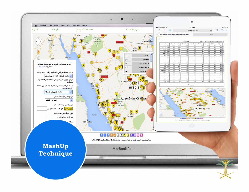
MashUpTechnique