Embed Size (px)
Citation preview
13
15
Talbot Tr
Talbot Rd E
Mersea Rd 10
Mersea Rd 11
Sim
pso
nS
drd
Mersea Rd 2
Mersea Rd C
Mersea Rd B
Whe
atle
y R
d
Eri
e S
t S
Deer Run Rd
Mersea Rd 1
Deer Run R
d
Man
ery
Sd
rd
Mersea Rd D
Pier Rd
Mersea Rd 4
RobsonRd
Eri
e S
t N
Bevel Line Rd
Point Pelee Dr
Oak St E
Seacliff Dr E
Klondyke Rd
Dan
fort
h A
v
Mersea Rd A
Middleton Ln
Hill
man
Sd
rd
Milo
Rd
Mersea Rd 2
Talbot Rd W
3rd C
oncession Ln
Fox Run Rd
Mersea Rd E
Talbot T
r
Bea
ch R
d
Mer
sea
Rd
19
Wheatley
WheatleyProvincial Park
Hillman MarshConservation Area
Kopegaron WoodsConservation Area
Two CreeksConservation Area
Mennonite Home
Erie GlenManor
77
C h a t h a m - K e n t
E s s e x
Legend / LégendeOn-road / Sur la route
Off-road / Hors route
Alerts / Alertes
Distance / Distance (km)
Connection / Liaison
Hospital / Hôpital
Attraction / Attraction
Beach / Plage
Campground / Camping
Information / Renseignements
Lookout / Vue panoramique
Marina / Marina
Parking / Stationnement
Town Hall / Hôtel de ville
Washrooms / W.-C.
Winery / Vinicole
Conservation Area / Zone de protection de la nature
Provincial Park / Parc provincial de l'Ontario
Built-up / Secteur bâti
Cemetery / Cimetière
Park, Natural Area / Parc, Espace naturelMarsh / Marais
L a k e E r i eL a c É r i e
Point Pelee Dr
Mersea Rd EPoint Pelee
0 0.5 1 km
MAP 14 TRAIL LENGTH: 32.3 km
2.0
Point Pelee National Park
LAKE ERIE MAP 14 OF 22
Wheatley /Point Pelee
Ontario
3
1
37
37
20
34
33
Bridge (no shoulder)Pont (pas d'accotement)
Loose surface roadRoute en gravier
S-turn / rough pavement.Narrow bridge / no shoulderVirage en S. / pavé rugueuxPont étroit / pas d’accotement
RoundaboutExit onto Bevel Line RdCarrefour giratoireSortez sur Bevel Line Rd
33
0 1 2 kmScale
ï
Southernmost Pointof Mainland Canada
L’extrême sud du Canadacontinental – 42e parallèle
Cartography & Design © 2013 416.244.7881 www.mapmobility.com
Carolinian Canada EcoTrail Site / Site du sentier écologique Carolinian Canada
Parc national de laPointe-Pelée

16
E S
hore R
d
W S
hore
Rd
Cen
tre
Dyk
e R
d
Hen
der
son
Rd
East+West Rd
Parson's Rd
Vic
tori
a R
d
S Shore Rd
N Shore Rd
Stone R
d
Brown's Rd
Ste
war
t R
d
Coop
er Rd
W Pump Rd
Homeward Rd
Cur
ry D
yke
Rd
Ruggles Run
Clutto
n Rd
Mahoney Blvd
Dyke Rd
Scudder R
d
Lora
inR
d
Harris-Garno Rd
Old
Vineyard
Rd
E s s e x
LIGHTHOUSE POINTPROVINCIAL NATURE RESERVE
FISH POINT PROVINCIAL
NATURE RESERVE
Pelee Airport
Pelee IslandCampground
Pelee IslandWine Pavilion
Legend / LégendeOn-road / Sur la route
Off-road / Hors route
Alerts / Alertes
Distance / Distance (km)
Connection / Liaison
Hospital / Hôpital
Attraction / Attraction
Beach / Plage
Campground / Camping
Information / Renseignements
Lookout / Vue panoramique
Marina / Marina
Parking / Stationnement
Town Hall / Hôtel de ville
Washrooms / W.-C.
Winery / Vinicole
Conservation Area / Zone de protection de la nature
Provincial Park / Parc provincial de l'Ontario
Built-up / Secteur bâti
Cemetery / Cimetière
Park, Natural Area / Parc, Espace naturelMarsh / Marais
L a k e E r i eL a c É r i e
MAP 16b TRAIL LENGTH: 28 km
2.0
LAKE ERIE MAP 16b OF 30
Ontario
Pelee Island
0 0.5 1 kmScale
Ferry to Kingsville & Leamington
Ferry to Sandusky, Ohio
ï
Visit or call for schedules and otherinformation.
www.ontarioferries.com 1-800-661-2220 Visitez ou composez lepour obtenir les horaires et autres renseignements.
www.ontarioferries.com 1-800-661-2220
Traversier à Kingsville et Leam
ington
Cartography & Design © 2015 416.244.7881 www.mapmobility.com

1416
Pet
erso
n R
d
Rd 2 W
Heritage Rd
Rd 2 E
Arn
er T
ow
nlin
e R
d
Iler
Rd
Seacliff Dr
Mersea Rd 5
Mersea Rd 6
Mersea Rd 7
Mersea Rd 8
Mersea Rd 4
Uni
on
Av
McC
ain
Sd
rd
Gra
ham
Sd
rd
Talbot St W
Eri
e S
t S
Seacliff Dr W
Fo
x La3rd Conc Rd
Robson Rd
Talbot Rd
Main St W
Mersea Rd 3
Bevel Line Rd
Oak St W
Seacliff Dr E
Oak St E
Eri
e S
t N
Talbot St E
Ho
pe
La
She
rk S
t
Main St E
Fra
ser
Rd
Bru
ner
Rd
Mer
sea
Rd
12
Que
en S
t
Dan
fort
h A
v
Do
lso
nR
d
Mersea Rd 1
Elli
ott
St
Wig
le A
v
HuffmanRd
Marlborough St E
Mer
sea
Rd
12
LeamingtonKingsville
Union Beach
A.M. O'Neil Memorial Conservation Area
RomaClub
Cedar IslandPark & Beach
Cedar BeachConservation Area
Clark Beach
BreezyBeach
Ferry Terminal
Mennonite Home
ErieGlen
ManorLakesidePark
LittleEssex Beach
Pleasant ValleyCampground
Cedar CreekConservation Area
LeamingtonMunicipal
MarinaCedar Creek
Conservation Area
WatersBeach
Leamington District Memorial
John R ParkHomestead
Conservation Area
3
77
3
E s s e x
Lakeside Park
Rd 2 E
Fo
x L
a
Main St W
Heritage Rd
Kra
tz R
d
Main St E
Qu
een
St
Wig
le A
v
Div
isio
n S
t S
Eri
e A
v Cull DrPark St
Lakeview Av
Seacliff Dr
Div
isio
n S
t N
Erie St
Lan
sdo
wne
AvMill St W
Sandybrook Way
Div
isio
n R
d N
Pri
nce
Alb
ert
St
N
Wo
od
ycre
st A
v
Su
mac
Dr
James Av
Law
ndal
e A
v
Woodlawn Cr
Jasp
erso
n La
Aug
ustin
e D
r
Jasp
erso
n D
r
Vic
tori
a A
v
Do
ck Rd
Rem
ark
Dr
Mcd
ona
ld S
t
Will
iam
Av
Woodland St
Train Ct
Kingsville
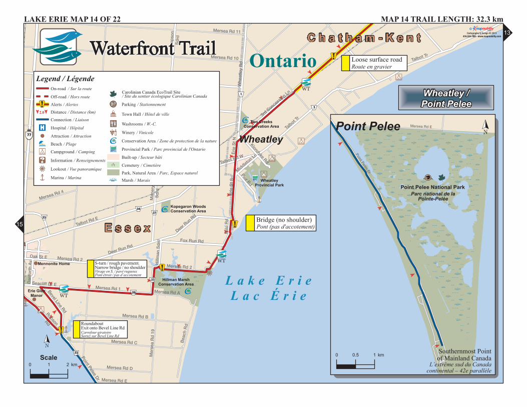
MAP 15 TRAIL LENGTH: 36.7 km
Roma Club
Mennonite HomeLeamington District
Memorial
Erie S
t S
Talbot St W
Seacliff Dr W
Oak St W
Oak St E
Seacliff Dr E
Talbot St E
Sh
erk St
Ellio
tt St
Fraser R
d
Mersea Rd 3
Ellison Av
Erie S
t N
Dan
forth A
v
Orange St
Ben
nie Av
Wig
le St
Lutsch AvFo
x St
Bevel Line Rd
Pulford Av
Mo
rse Rd
Alderton St
John St
Cherry L
a
Ivan St
Ho
dg
ins S
t
Prin
cess St
Mersea Rd 2
Seneca D
r
Sutton Dr
Robson Rd
Anfred
St
Russell St
Joann
e Ct
Sandy Lake Dr
Fuller Av
Cam
elot A
v
Po
plar S
t
Coronation Av
Cameo Dr
Marie C
r
Qu
eens Av
Ken
neth Dr
Go
slin
Ct
Parkdale Av
Leamington
0 0.5 1 km
Ontario
LAKE ERIE MAP 15 OF 22
Chrysler Canada Greenway 42 kms
Kingsville /Leamington
EnterChryslerCanada
Greenway
20
33
20
50
23 34
45
34
34
33
18
20
34
3448
33
33
20
29
29
50
Ferry to Pelee Island
Ferry to Pelee Island
0 0.5 1 km
L a k e E r i eL a c É r i e
Legend / LégendeOn-road / Sur la route
Off-road / Hors route
Alerts / Alertes
Distance / Distance (km)
Connection / Liaison
Hospital / Hôpital
Attraction / Attraction
Beach / Plage
Campground / Camping
Information / Renseignements
Lookout / Vue panoramique
Marina / Marina
Parking / Stationnement
Town Hall / Hôtel de ville
Washrooms / W.-C.
Winery / Vinicole
Conservation Area / Zone de protection de la nature
Provincial Park / Parc provincial de l'Ontario
Built-up / Secteur bâti
Cemetery / Cimetière
Park, Natural Area / Parc, Espace naturelMarsh / Marais
2.0
RoundaboutCarrefour giratoire
Bridge, wooden deckPont, terrasse en bois
Narrow bridge /No shoulderPont étroit /Pas d'accotement
Gate / Cyclist dismountBarrière / Les cyclistes doivent descendre
Ferr
y to
Pel
ee Is
landNarrow bridge /
No shoulderPont étroit /Pas d'accotement
0 1 2 kmScale
ï
Traversier à l’île Pelée Tr
aver
sier
à l’
île P
elée
Cartography & Design © 2013 416.244.7881 www.mapmobility.com

15
17
Pike Rd
3rd Conc Rd
4th Conc Rd
7th Conc Rd
Heritage Rd
Concession 6 Rd
Gore Rd
7th
Co
nc S
Arn
er T
ow
nlin
e R
d
5th Conc Rd
Iler
Rd
Eri
e R
d
Fer
ris
Rd
Dun
n R
d
5th
Co
nc S
9th
Co
nc S
Ho
war
d A
v
Concession 8 Rd
Mar
sh R
d
4th
Co
nc S
S Malden Rd
Potlake Rd Rid
ge
Rd
South Sdrd
McLeod Av
Cre
ek R
d
Co
ulte
r S
drd
Wri
ght
Rd
Huffman Rd
Bel
l Rd
Collison Sdrd
Simcoe St
Fer
ris
Sd
rd
Fry
er S
t
6th
Co
nc S
Lowes Sdrd
R
Mea
do
ws
Rd
3rd
Co
nc S
Fo
x S
drd
Mel
och
e R
d
Que
en S
t
Gia
rdin
i Rd
Sm
ith R
d
Lakeside Rd
Do
lso
nR
d
San
dw
ich
St
SAlma St
Mcc
orm
ick
Rd
Wal
ker
Rd
Lakewood Dr
John
son
Rd
Riz
zo N
ico
la R
d
Dru
mm
on
d R
d
Malden Rd
Arn
er T
ow
nlin
e R
d
South Sdrd
4th Conc Rd
Sm
ith R
d
Ho
war
d A
v Fer
ris
Rd
6th
Co
nc S
Heritage Rd
5th Conc Rd
Colchester
Harrow
Amherstburg
Lypps Beach
Craig Beach
Clark Beach
Willow Beach
Pigeon Beach Argyle Beach
BreezyBeach
Crystal Beach
Lakewood Beach
Goodview Beach
McCarthy BeachBelcreft Beach
Cornwall Beach
Northrop Beach
Levergood Beach
EvergreenBeach
Ambassador Beach
CloverdaleBeach
MNR MigrantBirds Lookout
Cedar CreekConservation Area
John R ParkHomestead
Conservation Area
Holiday BeachConservation Area
Klie's Beach
WatersBeach
BluewaterBeach
Maple LeafBeachPoplar Bluff
Beach
SunsetBeach
Bailey'sBeach
FortMaldenNationalHistoric
Site
Brumor YachtClub
White SandsConservation Area
Big CreekConservation Area
North 42DegreesEstateWinery
OxleyEstateWinery
PaglioneEstateWinery
Lieu historique national du Fort-Malden
E s s e x
Legend / LégendeOn-road / Sur la route
Off-road / Hors route
Alerts / Alertes
Distance / Distance (km)
Connection / Liaison
Hospital / Hôpital
Attraction / Attraction
Beach / Plage
Campground / Camping
Information / Renseignements
Lookout / Vue panoramique
Marina / Marina
Parking / Stationnement
Town Hall / Hôtel de ville
Washrooms / W.-C.
Winery / Vinicole
Conservation Area / Zone de protection de la nature
Provincial Park / Parc provincial de l'Ontario
Built-up / Secteur bâti
Cemetery / Cimetière
Park, Natural Area / Parc, Espace naturelMarsh / Marais
L a k e E r i eL a c É r i e
Colio Estate Winery
Eri
e S
t S
Qu
een
St
King St EKing St W
Ro
seb
oro
ug
h R
d
Eri
e S
t N
Centre St E
Art
hur
St
S
Munger St W
Maple Av
Wal
nut
St
S
Sinasac St W
Sn
ake La
Munger St E
Sinasac St E
Clark St
Given Rd
Su
nset
Dr
Wellington St
Pollard Dr
Kael Dr
Centre St W
Wo
od
land
Dr
Sec
ord
Av
Shepley Ct
Harrow
0 0.5 1 km
MAP 16 TRAIL LENGTH: 38.5 km
Harrow /Colchester
Ontario
LAKE ERIE MAP 16 OF 22
2.0
Chrysler Canada Greenway 42 kms
Chrysler Canada Greenway
23
50
50
20
20
20
15
11
11
189
41
5
20
13
13
11
16
18
Narrow bridge /No shoulderPont étroit /Pas d'accotement
0 1 2 kmScale
ï
Cartography & Design © 2013 416.244.7881 www.mapmobility.com
Carolinian Canada EcoTrail Site / Site du sentier écologique Carolinian Canada

16
18
Lypps Beach
RantaMarina
SunsetBeach
Willow Beach
Pigeon BeachArgyle Beach
Hotte Harbour
Crystal Beach
Bailey's Beach
LakewoodBeach
Goodview Beach
McCarthy BeachBelcreft Beach
Holiday Harbour
Levergood Beach
St. Clair Marine
Mueller's MarinaRiver Run Harbor
Ambassador Beach
Brumor YachtClub
Island View Marina
Riverfront Harbour
Acali Place Marina
Dean ConstructionCo Ltd
Amherstburg-EssexGreenway
Big CreekConservation Area
Petite CoteConservation Area
White SandsConservation Area
Crystal BayConservation Area
Holiday BeachConservation Area
Fort MaldenNationalHistoric Site
MNR Migrant Birds Lookout
Lieu historiquenational duFort-Malden
Wal
ker
Rd
Alma St
Ho
war
d A
v
Texas Rd
Pike Rd
North Sdrd
Middle Sdrd
Heritage Rd
5th
Co
nc N
6th
Co
nc N
4th
Co
nc N
8th
Co
nc N
3rd
Co
nc N
7th
Co
nc S
S Talbot Rd
Gore Rd
Fron
t Rd
N
3rd Conc Rd
Talbot Rd
Maiden Rd
5th
Co
nc S
14th Conc
Front Rd
4th Conc Rd
2nd
Co
nc
N
9th
Co
nc S
N Malden Rd
4th
Co
nc S
Mar
sh R
d
S Malden Rd
12th Conc Rd
N Townline Rd
Wal
ker
Sd
rd
Dis
put
ed R
d
Fro
nt R
d S
Brush S
drd
7th Conc Rd
Eri
e R
d
Martin LaF
ryer
St
Dun
n R
d
Mcleod Av
Concession 13 Rd
Bro
der
ick
Rd
Cre
ek R
d
Trembley S
drd
Kelly Rd
Wri
ght
Rd
Co
nces
sio
n 6
Rd
Victory St
Collison Sdrd
Potlake Rd
Simcoe St
Mel
och
e R
d
Co
nces
sio
n 8
Rd
Lowes Sdrd
Snake Lane Rd
Huron C
hurch Line Rd
11th Conc Rd
Matchette R
d
Cam
pbell Sdrd
Sand
wich S
t S
Ric
hmo
nd
St
Mea
do
ws
Rd
3rd
Co
nc S
Ed
gar
Sd
rd
Fo
x S
drd
Eri
e S
t S
Dal
hous
ieS
t
Que
en S
t
Sm
ith R
d
Lakeside Rd
Tho
mas
Rd
Townline Rd
5th Conc RdM
clea
n R
d
S Riverview
Dr
King St E
Mal
den
-co
lche
ster
So
uth
To
wnl
ine
Rd
Lakewood Dr
Dru
mm
on
d R
d
Sand
wich S
t N
Linwood Dr
Concession 7 Rd
Townline Rd
Middle Sdrd
Ho
war
d A
v Dru
mm
on
d R
d
6th
Co
nc S
Cam
pb
ell S
drd
Concession 6 Rd
Marsh Rd
Mal
den
Rd
Middle Sdrd
Sm
ith R
d
5th Conc Rd
LaSalle
Amherstburg
E s s e x
3
Legend / LégendeOn-road / Sur la route
Off-road / Hors route
Alerts / Alertes
Distance / Distance (km)
Connection / Liaison
Hospital / Hôpital
Attraction / Attraction
Beach / Plage
Campground / Camping
Information / Renseignements
Lookout / Vue panoramique
Marina / Marina
Parking / Stationnement
Town Hall / Hôtel de ville
Washrooms / W.-C.
Winery / Vinicole
Conservation Area / Zone de protection de la nature
Provincial Park / Parc provincial de l'Ontario
Built-up / Secteur bâti
Cemetery / CimetièrePark, Natural Area / Parc, Espace naturel
Marsh / Marais
Brumor Yacht Club
White Sands Conservation Area
Amherstburg Chamber ofCommerce
Fort MaldenNational
Historic Site
King'sNavyYardPark
Lieu historiquenational duFort-Malden
Alma St
Fry
er S
t
Simcoe St
Mel
och
e R
d
Lowes Sdrd
Dalhousie S
tS
andw
ich S
t S
Richmond St
Fort St
Tho
mas
Rd
Gore St
Kin
g S
t Pike Rd
Murray St
Park St
2nd
Co
nc S
Mccurdy Dr
Sand
wich
St N
Duff Av
Pacific A
v
Middle Sdrd
Lair
d A
v S
Saint Arnaud St
States A
v
Cry
stal
Bay
Dr
Crownridge Blvd
Illin
ois
St
Mai
n S
t S
Vene
tian
Dr
William St
Bratt Dr
Brunner Av
Bal
tic
Av
Vermont DrBo
ard
wal
k A
v
Go
ld C
oast Dr
Briar Ridge Av
Amherstburg
0 0.5 1 km
MAP 17 TRAIL LENGTH: 38.3 km
Amherstburg
LAKE ERIE MAP 17 OF 22
2.0
Ontario
20
20
9
5
16
50
18
510
20
3
3
8
11
Ferry
Railway crossingPassage à niveau
Sharp S-turn with hillVirage serré en S. avec colline
Bridge, no shoulderPont, pas d'accotement
Railway crossingPassage à niveau
Narrow bridge, no shoulderPont étroit, pas d'accotement
Narrow bridge, cyclists dismountPont étroit, les cyclistes doivent descendre
0 1 2 kmScale
ï
Cartography & Design © 2013 416.244.7881 www.mapmobility.com
Carolinian Canada EcoTrail Site / Site du sentier écologique Carolinian Canada