Embed Size (px)
Citation preview

Assessing the Impact of RO Refractivity on the
Analysis and Prediction of Typhoon Morakot (2009)
with a New Data Assimilation Strategy
Xingqin Fang and Ying-Hwa Kuo
COSMIC Program Office, UCAR, Boulder, CO, USA
April 2, 2012
1
Outline:
1. A new data assimilation strategy for refractivity
2. Case overview of Typhoon Morakot (2009)
3. Experiments design
4. Encouraging positive results
5. Conclusions and discussions
2
Objective: To improve the performance of local operator of
refractivity for typhoon analysis and forecast

3
A new data assimilation strategy
for refractivity
4
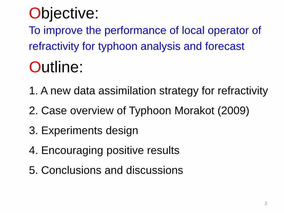
Observation resolutions of N --- Clarify “vertical resolution”
1 & 2 specific treatment for vertical error correlation
2 & 3 specific representative errors
1. N_ar vertical resolution of retrieval
~10-50m (observation density)
2. N_ar vertical resolution of information
~100-200m near surface,
~500-1000m in troposphere,
~1000-2000m in stratosphere
3. N_mod vertical resolution
--- Vary with NWP model
5
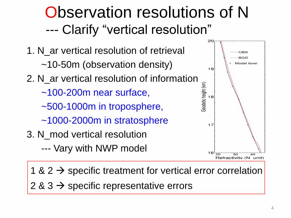
Observational error correlation
1. Variable transformation -- n/a for N
2. Thinning via super-obs -- n/a for monotonic N
3. Non-diagonal error matrix -- n/a for ensemble
4. Cost function down-weighting -- n/a for ensemble
5. Adaptive inflation -- OK for ensemble, still developing
6. Thinning via down-sampling
-- OK for N
-- OK for both ensemble and variational
-- Simplest to implement
This deserves further investigation…
✔
6
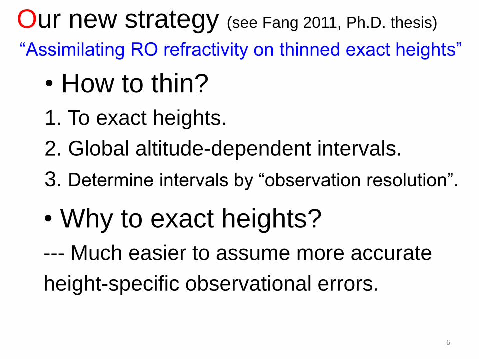
• How to thin?
1. To exact heights.
2. Global altitude-dependent intervals.
3. Determine intervals by “observation resolution”.
Our new strategy (see Fang 2011, Ph.D. thesis)
“Assimilating RO refractivity on thinned exact heights”
• Why to exact heights?
--- Much easier to assume more accurate
height-specific observational errors.
7
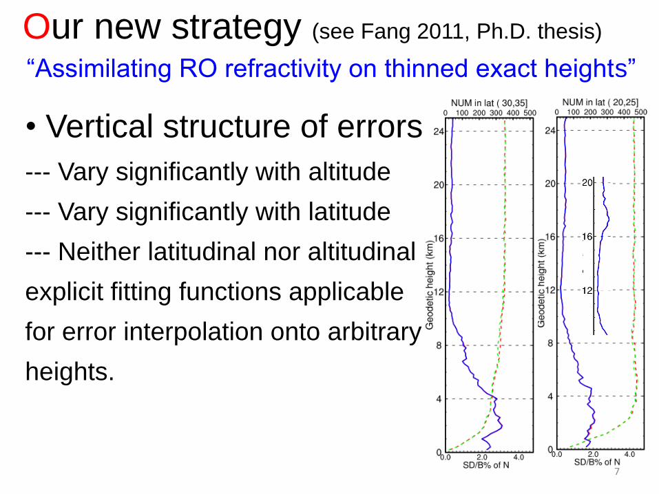
Our new strategy (see Fang 2011, Ph.D. thesis)
“Assimilating RO refractivity on thinned exact heights”
• Vertical structure of errors
--- Vary significantly with altitude
--- Vary significantly with latitude
--- Neither latitudinal nor altitudinal
explicit fitting functions applicable
for error interpolation onto arbitrary
heights.
8
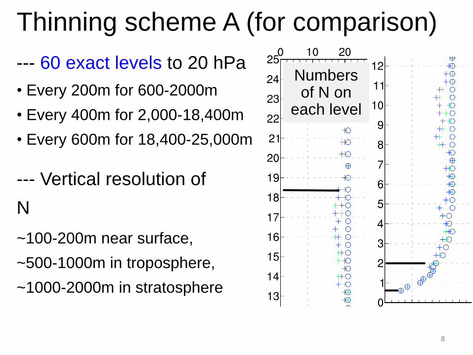
Thinning scheme A (for comparison)
--- 60 exact levels to 20 hPa
• Every 200m for 600-2000m
• Every 400m for 2,000-18,400m
• Every 600m for 18,400-25,000m
--- Vertical resolution of
N
~100-200m near surface,
~500-1000m in troposphere,
~1000-2000m in stratosphere
Numbers of N on
each level
9
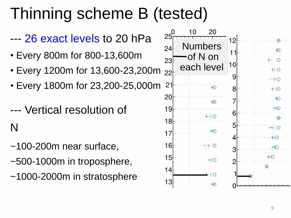
Thinning scheme B (tested)
--- 26 exact levels to 20 hPa
• Every 800m for 800-13,600m
• Every 1200m for 13,600-23,200m
• Every 1800m for 23,200-25,000m
--- Vertical resolution of
N
~100-200m near surface,
~500-1000m in troposphere,
~1000-2000m in stratosphere
Numbers of N on
each level

10
Case overview of
Typhoon Morakot (2009)
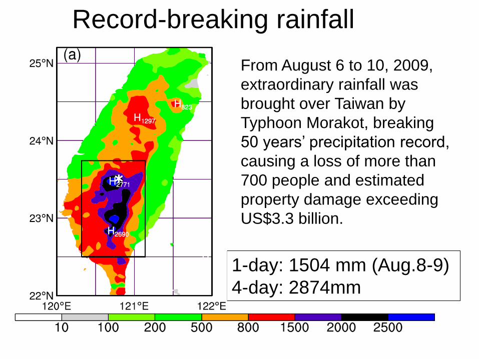
1-day: 1504 mm (Aug.8-9)
4-day: 2874mm
Record-breaking rainfall
From August 6 to 10, 2009,
extraordinary rainfall was
brought over Taiwan by
Typhoon Morakot, breaking
50 years’ precipitation record,
causing a loss of more than
700 people and estimated
property damage exceeding
US$3.3 billion.
12
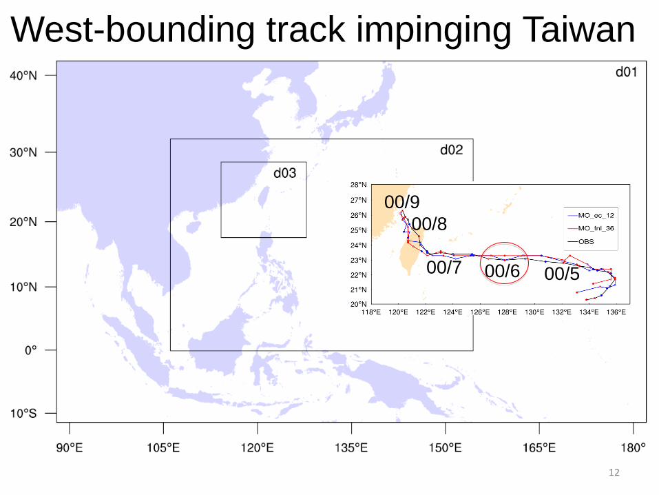
West-bounding track impinging Taiwan
00/6
00/5 00/7
00/8
00/9
13
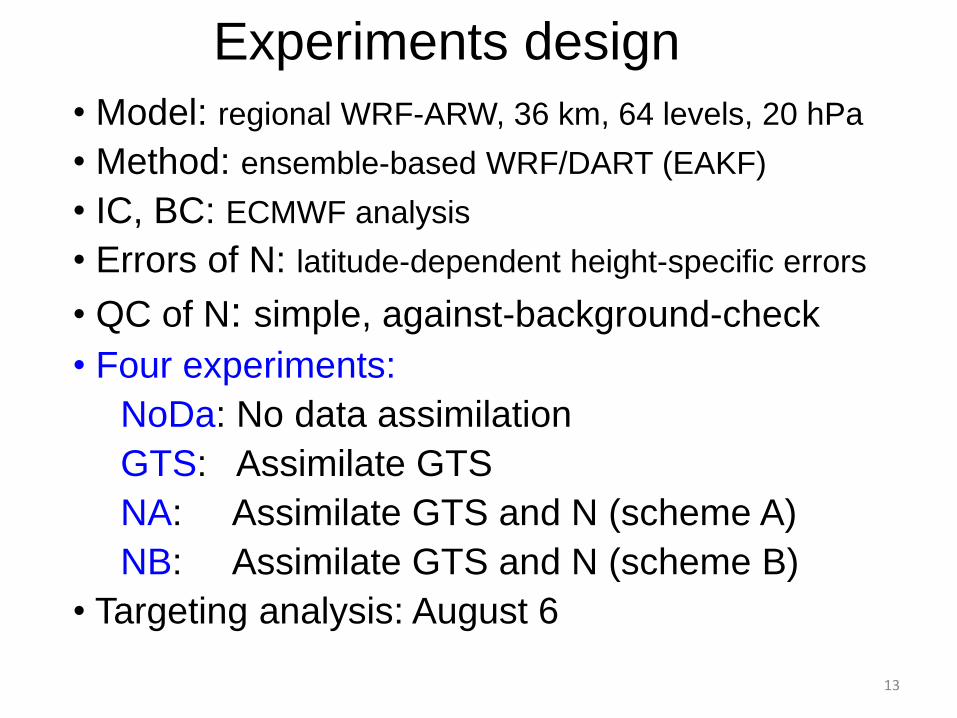
Experiments design
• Model: regional WRF-ARW, 36 km, 64 levels, 20 hPa
• Method: ensemble-based WRF/DART (EAKF)
• IC, BC: ECMWF analysis
• Errors of N: latitude-dependent height-specific errors
• QC of N: simple, against-background-check
• Four experiments:
NoDa: No data assimilation
GTS: Assimilate GTS
NA: Assimilate GTS and N (scheme A)
NB: Assimilate GTS and N (scheme B)
• Targeting analysis: August 6
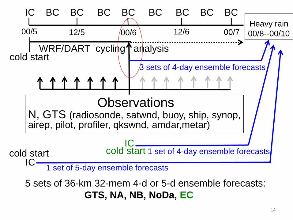
14
cold start WRF/DART cycling analysis
3 sets of 4-day ensemble forecasts
Observations N, GTS (radiosonde, satwnd, buoy, ship, synop, airep, pilot, profiler, qkswnd, amdar,metar)
Heavy rain
00/8--00/10
00/5
12/5
00/6
12/6
00/7
IC BC BC BC BC BC BC BC BC
IC
IC cold start cold start
5 sets of 36-km 32-mem 4-d or 5-d ensemble forecasts:
GTS, NA, NB, NoDa, EC
1 set of 4-day ensemble forecasts
1 set of 5-day ensemble forecasts
15
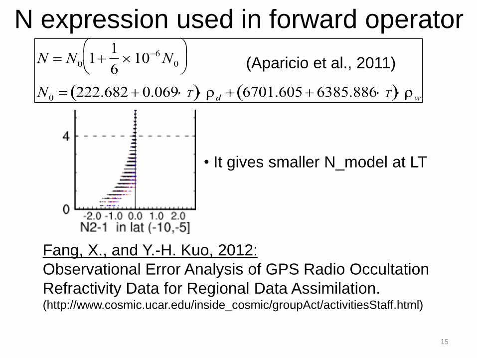
N N0 11
6106N0
N0 222.6820.069 T d 6701.6056385.886 T w
(Aparicio et al., 2011)
N expression used in forward operator
• It gives smaller N_model at LT
Fang, X., and Y.-H. Kuo, 2012:
Observational Error Analysis of GPS Radio Occultation
Refractivity Data for Regional Data Assimilation. (http://www.cosmic.ucar.edu/inside_cosmic/groupAct/activitiesStaff.html)
16
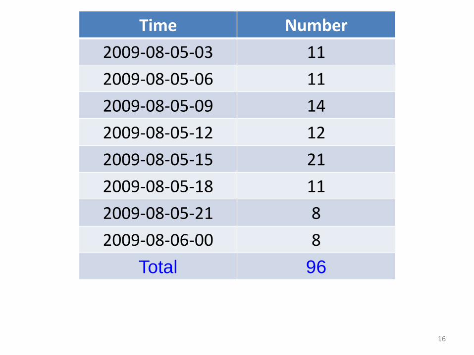
Time Number
2009-08-05-03 11
2009-08-05-06 11
2009-08-05-09 14
2009-08-05-12 12
2009-08-05-15 21
2009-08-05-18 11
2009-08-05-21 8
2009-08-06-00 8
Total 96

17
Encouraging positive results
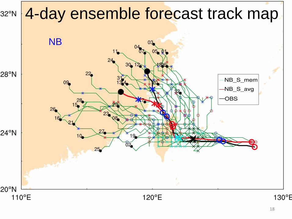
18
4-day ensemble forecast track map
NB
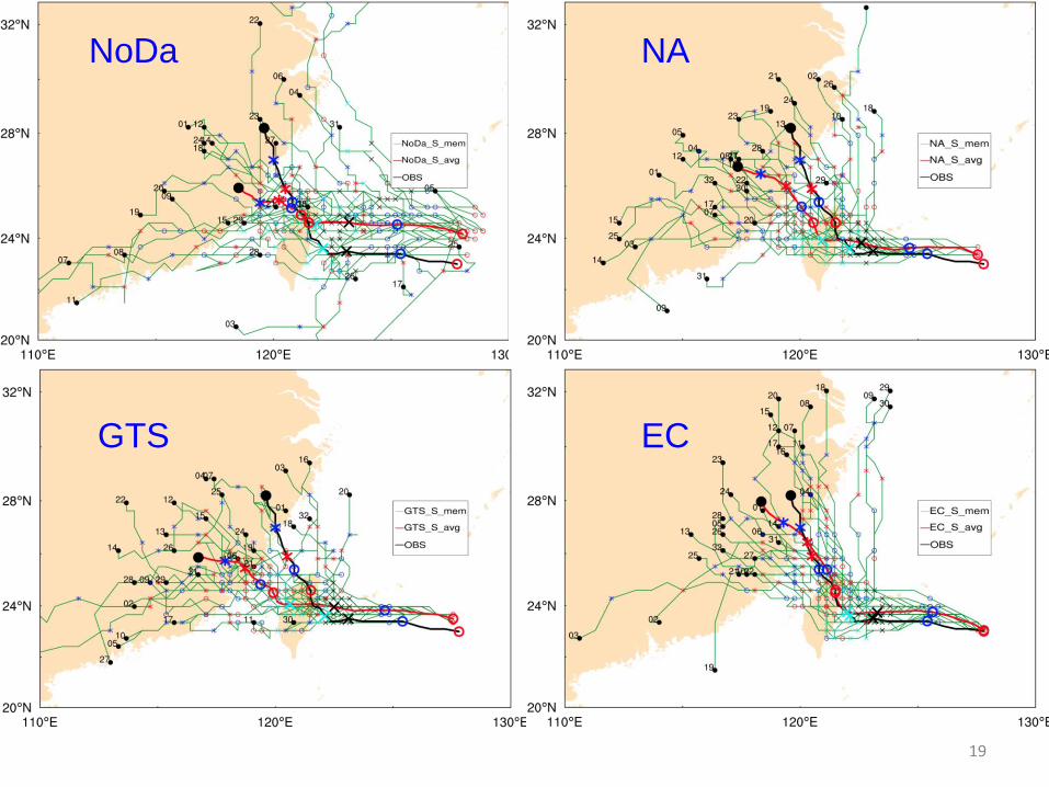
19
NoDa NA
GTS EC
20
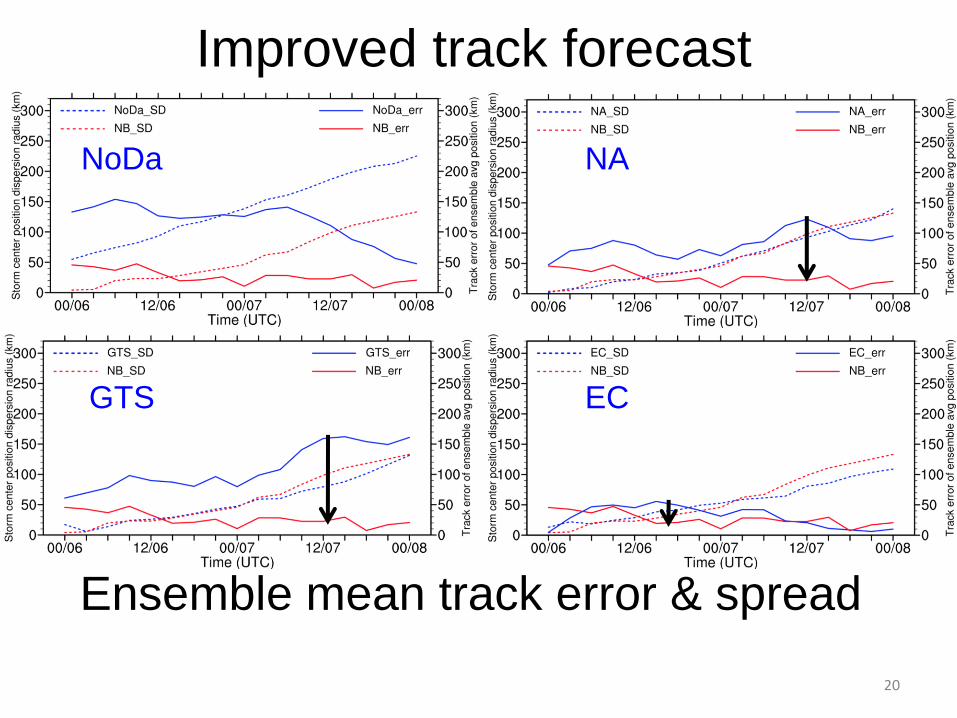
Ensemble mean track error & spread
Improved track forecast
GTS
NA
EC
NoDa
21
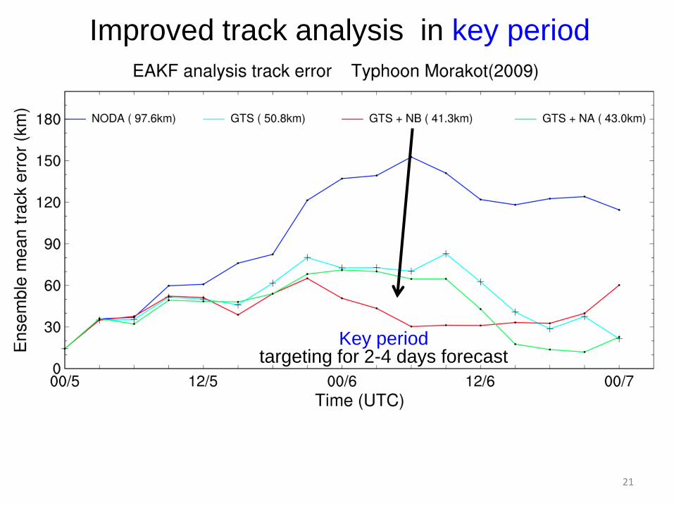
Improved track analysis in key period
Key period targeting for 2-4 days forecast
22
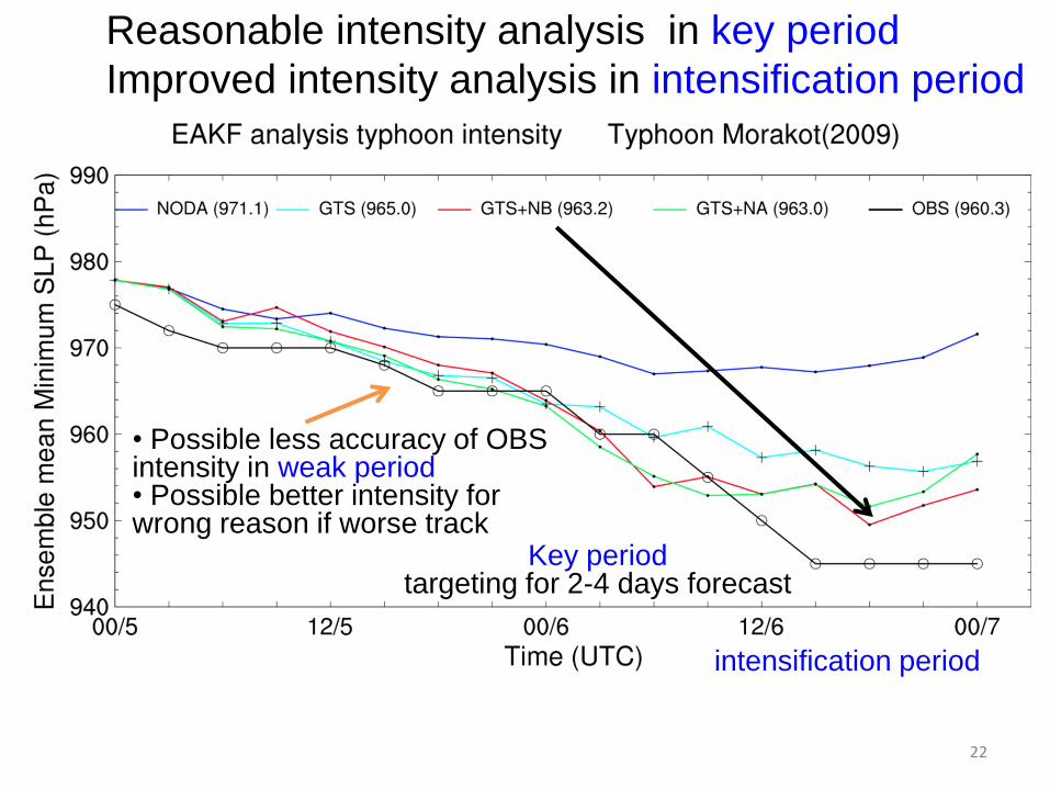
Reasonable intensity analysis in key period
Improved intensity analysis in intensification period
Key period targeting for 2-4 days forecast
• Possible less accuracy of OBS intensity in weak period • Possible better intensity for wrong reason if worse track
intensification period
23
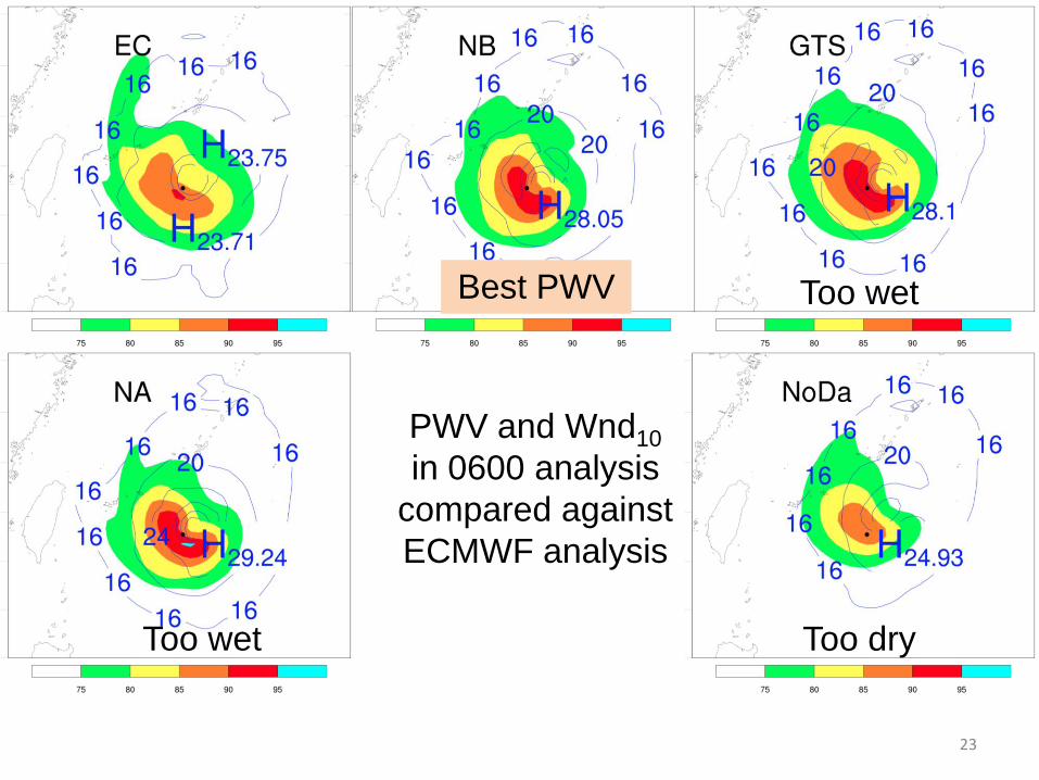
PWV and Wnd10
in 0600 analysis
compared against
ECMWF analysis
Best PWV
Too wet
Too dry
Too wet
24
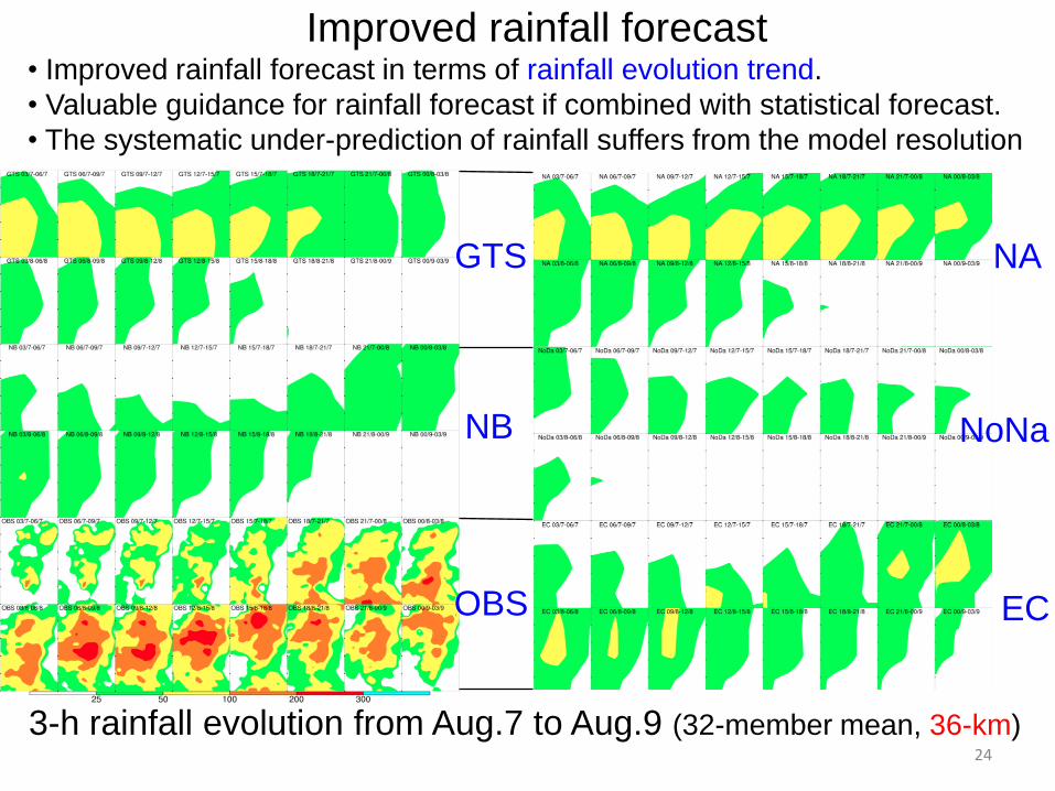
Improved rainfall forecast • Improved rainfall forecast in terms of rainfall evolution trend.
• Valuable guidance for rainfall forecast if combined with statistical forecast.
• The systematic under-prediction of rainfall suffers from the model resolution
3-h rainfall evolution from Aug.7 to Aug.9 (32-member mean, 36-km)
NB
OBS
GTS NA
NoNa
EC
25
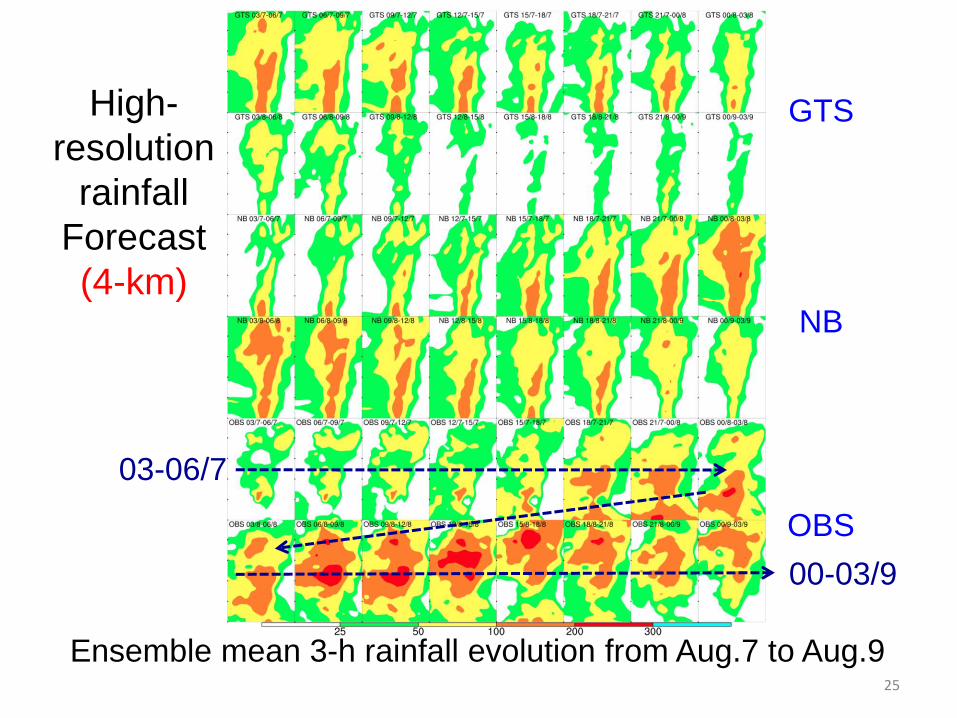
GTS
NB
OBS
High-
resolution
rainfall
Forecast
(4-km)
Ensemble mean 3-h rainfall evolution from Aug.7 to Aug.9
03-06/7
00-03/9
26
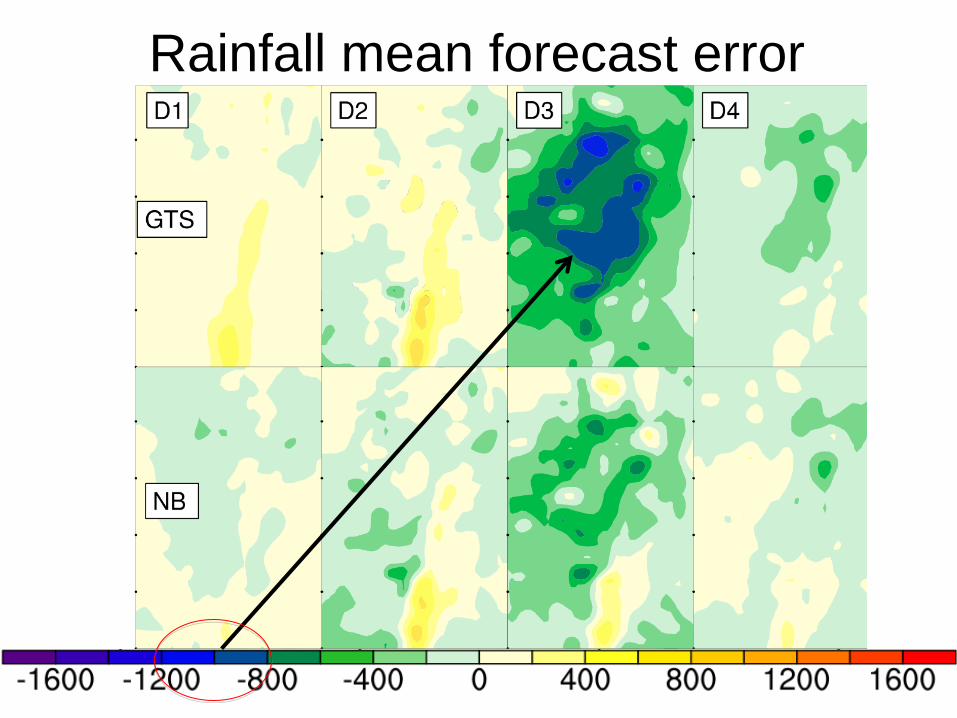
Discussions
on intervals in LT
Rainfall mean forecast error
27
Conclusions: 1.A new data assimilation strategy of refractivity is introduced to
improve the performance of the local operator of refractivity. GPS
refractivity retrievals are vertically correlated. Thinning the
refractivity profile in a manner consistent with the true information
content improves the performance of refractivity data
assimilation.
2.The artful point of this new strategy is to thin the profile on
exact heights rather than arbitrary heights, which is helpful in
assuming more accurate height-specific observational errors.
3.The assimilation of GPS refractivity data using this new
strategy with a high-resolution WRF/DART ensemble-based data
assimilation system improves the typhoon track and moisture
analysis and the rainfall forecast. --------- End -------
Thanks for you attention!


![Diversifying Trending Topic Discovery via Semidefinite ...yfang/IEEE-Bigdata-Fang.pdf · TwitterMonitor, a framework for online trend detection in Twitter. Weng et al. [19] use a](https://img.pdfslide.net/doc/110x75/5ed36ad7e450f87a2052e68e/diversifying-trending-topic-discovery-via-semideinite-yfangieee-bigdata-fangpdf.jpg)