Embed Size (px)
Citation preview

YARRA RANGES COUNCIL
GREEN WEDGE MANAGEMENT PLAN
Adopted 27 July 2010

2
Acknowledgements
This Plan has been prepared by Yarra Ranges Council with the assistance of a grant from the Department of Planning and Community Development.

3
Contents
EXECUTIVE SUMMARY.................................................................................................4
YARRA VALLEY, YARRA AND DANDENONG RANGES GREEN WEDGE…………….6 STATE AND LOCAL PLANNING CONTEXT………………………………………………11
DEVELOPING THE GREEN WEDGE MANAGEMENT PLAN......................................13
PROCESS AND CONSULTATION………………………………………………………….18 A VISION FOR THE GREEN WEDGE..........................................................................20
Overarching Issues........................................................................................................22
Agriculture .....................................................................................................................30
Biodiversity ....................................................................................................................38
Landscape Management ...............................................................................................47
Tourism and Leisure......................................................................................................51
Rural Living ...................................................................................................................56
Cultural Heritage……………………………………………………………………………….59
NEXT STEPS ................................................................................................................60

4
Executive Summary
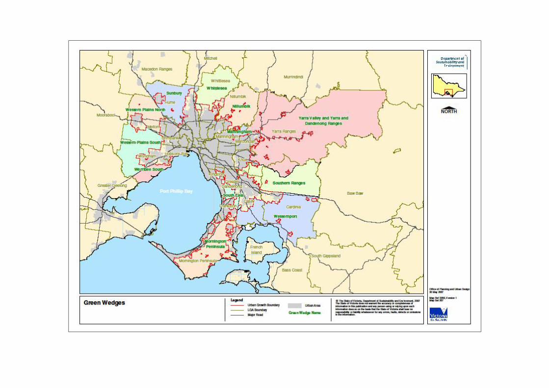
Melbourne’s green wedges make an important contribution to the liveability, economic strength and environmental health of Melbourne. The Melbourne 2030 vision for green wedges is to encourage their proper management and to protect them for non-urban uses. The Yarra Valley and Yarra and Dandenong Ranges Green Wedge is one of 12 green wedges identified in Melbourne 2030. The majority of this green wedge falls within the boundary of the Yarra Ranges Council, however small parts of it extend into the neighbouring municipalities of Casey, Cardinia, Maroondah and Knox. (See map on the following page). The State Government has required all green wedge councils to prepare a Green Wedge Management Plan. The purpose of the Green Wedge Management Plan is: § To establish a vision and set of objectives for the Yarra Ranges portion of the
Yarra Valley and Yarra and Dandenong Ranges green wedge which is shared by all levels of government, land owners, land managers and the community.
§ To identify a set of policies, programs and actions that support the ongoing sustainable management of the Yarra Ranges green wedge.
The Yarra Ranges Green Wedge encompasses diverse activities including: rural living, agriculture, rural industry, water catchments, tourism facilities and State and national parks. Understandably the community holds different expectations for how the Green Wedge should be managed. Council and the community must meet the challenge to manage these pressures, so that the assets which make up the Green Wedge are kept in place for future generations to enjoy. The green wedge vision statement takes account of all of this and articulates the community’s priorities as stated in Vision 2020 and this consultation, to preserve the green wedge as a valued resource for the local community and the people of Melbourne into the future. The shared vision for the Yarra Ranges Green Wedge is: The Yarra Ranges community will encourage and support sustainable farming, a healthy biodiversity, and valued landscapes in its Green Wedge. These are the primary green wedge values and are what make it attractive for other activities such as tourism, recreation, and rural living. Council will work with the community and other stakeholders to protect and enhance these primary values. Other activities will only be accommodated if they positively contribute to the primary values. The key challenges in achieving this vision are: § ensuring that the planning framework reflects the primary values of the Green
Wedge and that planning decisions are consistent with the vision, § prioritising Council’s resources to deliver effective programs to enhance these
primary values and, § establishing partnerships with the landowners, stakeholders and State and local
authorities to assist in their delivery. In real terms adopting this vision means that Council will actively discourage further subdivision or development of rural land that does not uphold the primary values and only support sustainable land management practices.
6
YARRA VALLEY, YARRA AND DANDENONG RANGES GREEN WEDGE
Yarra Ranges’ green wedge encompasses approximately 237,000 hectares making it the largest of Melbourne’s 12 green wedges. The Green Wedge contains distinct geographic areas, the Yarra Valley and the Yarra and Dandenong Ranges and represents 95% of the total land in the municipal area. The area contains rich volcanic soils, extensive forest cover and relatively high rainfall. Approximately 70% of green wedge land is managed by State and Government agencies – a large portion of which was set aside by Melbourne’s forefathers as a closed catchment for Melbourne’s water supply.
The natural environment of the green wedge provides important habitat for many threatened flora and fauna species, vital ecological services and carbon sequestration. The environmental importance and scenic values of the area attracts visitors from Melbourne, Victoria, Australia and overseas. Fertile land and reliable rainfall make agriculture a significant land use. The proximity to Melbourne helps to reduce the environmental impact of delivering food to the metropolitan area. The fine food and wine industry of the Yarra Valley is a major tourism attraction.
Key features and values for Melbourne
Biodiversity The area is rich in biodiversity, containing flora and fauna of regional, state and national significance. The green wedge provides an important habitat refuge for many rare and threatened species. The ecosystem services provided by the region support all sectors of the community and are an essential element of Melbourne’s liveability.
Agriculture The climate, soils, rainfall and proximity to markets make this green wedge one of the most intensively farmed areas in the State. Major industries include flowers, nursery plants, berry and orchard fruits, wine grapes, beef and grain. The agricultural produce of the Green Wedge contributes $222 million dollars to Victoria’s economy and helps to ensure a supply of healthy and affordable food needed for Melbourne’s growing population.

7
Landscape One of the defining features of Yarra Ranges green wedge are the scenic landscapes that include mountain ranges, rich valley floors, extensive waterway networks and thick temperate forest. National and State parks cover much of the region, famed for their natural appeal and scenic beauty. Valued landscapes are not just confined to ‘natural’ landscapes - many treasured landscapes are significantly modified such as cultivated croplands and rolling pastures.
Water Sustainable and safe water resources are fundamental to Melbourne’s long-term prosperity. A significant proportion of Melbourne’s drinking water comes from water catchments in the Yarra Ranges. Almost the entire green wedge falls within the Mid-Yarra River catchment and a smaller part within the Dandenong Creek catchment. Yarra Ranges contains important water storage areas, including the Upper Yarra, Silvan, Maroondah and O’Shannassy Reservoirs.
Tourism This green wedge supports a variety of tourism and leisure activities that attract 1.6 million people annually and generates $300 million to the local ecomony. Iconic attractions gaining local and international recognition include Healesville Sanctuary, Puffing Billy and the fine food and wine producing region of the Yarra Valley. Other attractions include health and wellbeing facilities, B & B’s and craft and produce markets.
8
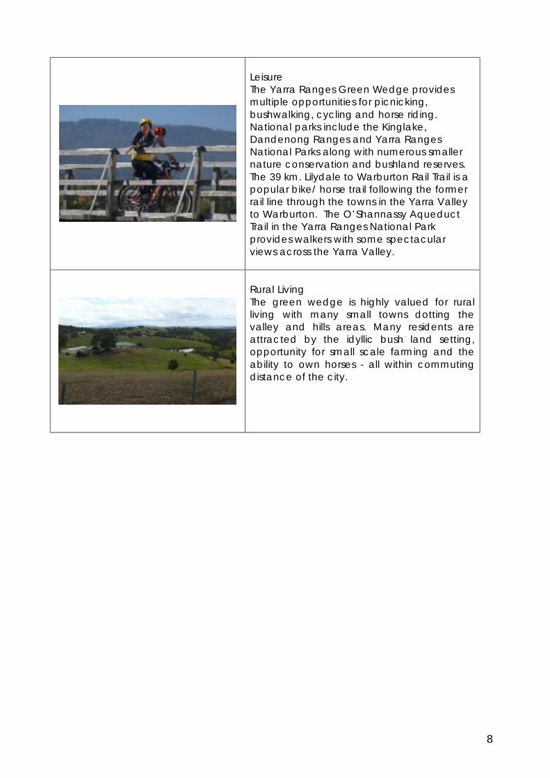
Leisure The Yarra Ranges Green Wedge provides multiple opportunities for picnicking, bushwalking, cycling and horse riding. National parks include the Kinglake, Dandenong Ranges and Yarra Ranges National Parks along with numerous smaller nature conservation and bushland reserves. The 39 km. Lilydale to Warburton Rail Trail is a popular bike/ horse trail following the former rail line through the towns in the Yarra Valley to Warburton. The O’Shannassy Aqueduct Trail in the Yarra Ranges National Park provides walkers with some spectacular views across the Yarra Valley.
Rural Living The green wedge is highly valued for rural living with many small towns dotting the valley and hills areas. Many residents are attracted by the idyllic bush land setting, opportunity for small scale farming and the ability to own horses - all within commuting distance of the city.

9
Study Area The study area for this Plan includes all rural land within Yarra Ranges Council - Green Wedge, Green Wedge A, Rural Conservation, Special Use, Public Park and Recreation, Public Conservation and Resource and Public Use zones (Map 1). The study area broadly coincides with one of twelve green wedge precincts identified in Melbourne 2030, known as the Yarra Valley and Yarra and Dandenong Ranges Green Wedge. The Melbourne 2030 precinct extends slightly into the neighbouring municipalities of Casey, Cardinia, Maroondah and Knox. All recommendations and actions in this Plan apply only to land within the boundaries of Yarra Ranges Council. Work for areas outside of the municipal boundary will be prepared at a later time by those municipalities.
Map 1- Study Area
Green Wedge – Land Use Map 2 broadly illustrates how the land is currently being used in the Green Wedge. The base data for this map comes from Agriculture Victoria Services Pty Ltd’s (AVS) mapping of the Port Philip Region completed in 2003. The Yarra Ranges information was complied in 2004 and is based on the classification system of Australian Land Use and Management which groups land use according to management objectives, commodities, land management practices and land cover information. This work was further verified through extensive field work undertaken between May and July 2004. To present a legible map at this scale, several classifications were grouped together to illustrate the primary land uses in the Yarra Ranges Green Wedge. As can be seen the largest portion of land is held in conservation and State Forests, with significant areas of grazing, horticulture and rural residential.

10
Map 2

11
STATE AND LOCAL PLANNING CONTEXT In total, approximately thirty different jurisdictional land and waterway managers operate in the Green Wedge. Collectively, these managers apply controls, run land management programs and environmental projects - many already in place - to protect the Green Wedge and enhance its assets. This combined framework of controls, incentives, and education helps maintain a proactive approach to managing the Green Wedge. Council plays a lead role in promoting sustainable use and preservation of the Green Wedge as well as directly managing its own land.
State Policy Context Melbourne 2030 - The State Government’s metropolitan strategy, Melbourne 2030 provides the overarching framework for green wedge management plans. It directs that an individual action plan be prepared for each green wedge. Melbourne 2030 defined an Urban Growth Boundary (UGB) for Melbourne which also defines the boundary for the green wedges. Development is encouraged to consolidate on the urban side of the UGB and is prevented from intruding into rural areas by a range of Planning Scheme controls including the green wedge zones and provisions which limit urban growth and development. Melbourne @ 5 Million – updates Melbourne 2030 taking into account new population projections for the State. The report directs established suburban areas to accommodate greater numbers of households than were anticipated by Melbourne 2030. It also reaffirms the State Government’s commitment to protecting the twelve green wedges around metropolitan Melbourne including the Green Wedge in Yarra Ranges. The State Government recently announced changes to the UGB in some municipalities that also contain a growth corridor. No changes to the UGB were proposed for Yarra Ranges and future changes are considered unlikely given the long history of planning protection for the Dandenong Ranges, the foothill areas and the Yarra Valley. Upper Yarra Valley and Dandenong Ranges Regional Strategy Plan (RSP) –was originally prepared by a State Government appointed Regional Planning Authority to create a consistent framework for planning and land management issues across the region. It was prepared during the late 1970’s and early 1980’s at a time when the region comprised of four separate municipalities. Building on the principles of Statement of Planning Policy No. 31, it provided a detailed set of policies and requirements that were required by legislation to be reflected in local planning schemes. The Regional Planning Authority was disbanded following Council amalgamations and the formation of the Shire of Yarra Ranges in 1994. However the Planning and Environment Act continued to require that any amendments to the Yarra Ranges Planning Scheme must be consistent with the RSP. With the introduction of the Victoria Planning Provisions, the planning requirements of the RSP that could not be achieved under the standard State provisions were put into the Planning Scheme via a unique provision of the Yarra Ranges Planning Scheme, known as Clause 53.

12
Land and Biodiversity White Paper – produced by the Department of Sustainability and Environment the White Paper is a long-term, strategic framework to secure the health of Victoria’s land, water and biodiversity in the face of ongoing pressures and a changing climate over the next fifty years. The Victorian Government’s agenda is to: build ecosystem resilience across Victoria, manage flagship areas to maintain ecosystem services and improve connectivity in areas identified as biolinks. The actions in the White Paper support and assist the work that Council will be undertaking in the implementation of the Green Wedge Management Plan.
Council Strategies and Plans A number of local strategies and policy statements influence land use and activities in the Green Wedge. They are described briefly below: § Vision 2020 – A vision of the Yarra Ranges Community - the community plan for Yarra
Ranges expresses a vision for Yarra Ranges which stresses the value of the Green Wedge…’a rich mosaic of urban settlements, productive rural holdings, healthy waterways, native bush land and forest… one of the most beautiful natural environments in the nation.’ The vision also values agriculture within the Shire… ‘home to some of Australia’s most famous rural produce... its fresh flowers, fruit and market garden produce are flown out to markets in the Asia - Pacific Region.. its wines, cheeses and other food products are in demand around the world…’
§ Council Plan 2009- 2013 - the business plan for the organisation includes two
strategic objectives which are relevant to the Green Wedge: Environmental Stewardship - to improve the health and biodiversity of the natural environment for current and future generations, and Local Economy & Tourism - to improve the economic health and vitality of our communities through sustainable business practices and local job creation.
§ The Shire of Yarra Ranges Community Well Being Plan – the plan is designed to
enhance the health status of people who live, work, visit or study in the municipality. Key Result Area 2 – Protect, Maintain and Enhance Environmental Health states as its goal, ‘sustain the health and well being of communities by protecting and enhancing the Shire’s natural environment.’ Objectives relevant to this Green Wedge Plan are to enhance biodiversity, reduce the communities’ ecological footprint and reduce negative impacts on water quality.
§ Yarra Ranges Planning Scheme – is the most important control on land and
development. The Scheme provides the framework for land use, subdivision, and development incorporating State and metropolitan planning policy for future development. The Scheme also contains local content relevant to Yarra Ranges and its Green Wedge. While there is only limited scope to affect State planning provisions for the Green Wedge, there is room to amend the local provisions to better reflect local circumstances. The State Government has also encouraged local government to use the Green Wedge Management Plan process to identify any problems with the Victoria Planning Provisions. This Plan will investigate these opportunities. Relevant sections of the Planning Scheme are summarised in Appendix 1.

13
DEVELOPING THE GREEN WEDGE MANAGEMENT PLAN The Green Wedge represents the majority of land within the municipality and accordingly extensive review of the rural areas and related issues had occurred before this project commenced. The Green Wedge Management Plan therefore benefits from numerous existing strategies and studies as outlined below. This Plan does not intend to duplicate existing policies and directions but does incorporate relevant recommendations and actions from existing studies as well as proposing new strategies/projects arising from additional consultation and research. In order to keep the Plan manageable and useful there has been a deliberate attempt to focus on key issues in the Green Wedge where Council can influence outcomes. Therefore a major focus of the Green Wedge Management Plan is on land use and development issues which can be influenced through Council’s statutory powers.
Background Reports and Strategies The State of the Environment Report, Environment Strategy, Economic Development Strategy, Vision 2020 by Design and the Directions Paper - Local Planning Policy Review provided relevant background material and outline much of the work to be accomplished by this Plan. The Green Wedge Management Plan will progress many of the recommendations and actions identified in these municipal wide strategies. A diagram showing the relationship of the Green Wedge Management Plan to existing strategies is presented below. The principle contributing strategies are shown in yellow and brief summaries follow.
§ State of the Environment Report – highlights the importance and fragility of the natural environment in the Yarra Ranges Council and beyond. The report quantifies the current condition of natural assets, biodiversity and ecosystem health (where data is available). It also outlines the human impacts and pressures being placed on
Draft Flora and Fauna
Management Strategy
Weed Management Strategy
November - 2005
Economic Development Strategy
2005-2009 Environment Strategy 2008
Tourism Policy and Action Plan - 2009
Yarra Ranges Visitor Accommodation Strategy
2005
Green Wedge
Management Plan
State of the Environment Report - 2008
Draft Domestic Wastewater Management and Draft
Stormwater Management Strategies
Vision 2020 by Design May 2008
Intensive Rural Industries Review - 2004
Directions Paper: Local Planning Policy
Review
Reconciliation Shire of Yarra Ranges
Draft Recreation and
Open Space Strategy
Shire of Yarra Ranges Community Wellbeing Plan
2007-2010

14
the natural environment through consumption and waste behaviours and attempts to raise awareness of issues for the community.
§ Environment Strategy 2008 - considers issues of global and local significance including climate change and measures to reduce our ecological footprint. The Strategy touches on three of the most significant issues in the green wedge, agriculture, tourism and biodiversity. It includes a Council policy statement on Land Waterways and Wetlands (4.2.1) which recognises that high value agricultural land should be preserved for agriculture, and that landowners should adopt sustainable land management practices to reduce any impacts on the environment. The strategy also recognises that tourism depends largely on the retention, protection and enhancement of natural assets and advocates that tourism and recreation activities be complementary to the protection and enhancement of these assets.
The policy statement on Fauna and Flora (4.2.2) recognises that protecting and enhancing indigenous vegetation is of the highest importance to the long-term health of ecosystems, and that the highest priority for vegetation management is to protect existing indigenous vegetation of high habitat value. The incremental loss of vegetation must be abated or reversed because it contributes to an ongoing and gradual erosion of native vegetation and its ecosystem. The roadside reserves with remnant vegetation and habitat are particularly important to the Shire’s biodiversity. The draft Flora and Fauna Strategy is also a source of specific recommendations relating to this policy statement.
§ Economic Development Strategy and Action Plan 2005-2009 - is guided by Vision 2020 and includes two “key result areas” which highlight the importance of tourism and agribusiness to Council. Tourism & Cultural Development (KRA 3) envisages that tourism will continue to be a major industry and employer and that it will build on the Yarra Ranges’ strengths in wine, food, arts and culture, and the natural environment. Agribusiness (KRA 7) sees agriculture continuing to make a major contribution to Council’s economy by adding value to local produce and providing career opportunities for local people while sustainably managing land and water resources so as to minimise the adverse impacts on the environment.
§ Directions Paper – Local Planning Policy Review 2007 – was prepared to comply with
a Planning and Environment Act 1987 requirement that Council review its planning scheme regularly. The Directions Paper audited the performance of the planning scheme and recommended a more effective expression of Council’s policy directions. It recognised changes in the State Government strategic planning policies particularly in the green wedge areas…the new green wedge zones widen and strengthen the tools available to protect the green wedge and allow a more effective implementation of the Regional Strategy Plan.
§ Vision 2020 by Design – addresses the built environment or ‘look’ of the urban areas,
towns, villages and rural landscapes. The report recommends actions which will assist to preserve the valued characteristics of the Shire. These include guiding the location, look and design of new development. The report identifies nine distinct urban and rural area types and presents guidelines that will enhance future development and protect rural vistas.
§ Recreation and Open Space Strategy - guides Council decision making in prioritising
the provision of recreation and open space facilities and services. The Strategy assists Council to direct funds and support to the areas that are in the most need and offer the greatest benefit for the community. Council’s intention for recreation

15
and open space is to focus on partnerships, work with volunteer groups to implement services and facilities, support multi – use facilities and advocate for additional resources to implement recreation and open space initiatives.

16
Management – Incentives, Programs and Education Green wedge management requires a holistic approach. Council backs up its strategic statements with incentives and education programs shown in the following table.
Biodiversity Offsets Program - Protecting and enhancing indigenous vegetation is critical to the long-term health of ecosystems within the municipality and beyond. In accordance with State Legislation and Council Policy; vegetation removal is to be avoided. In the event that vegetation removal is not avoidable, losses must be minimised and then offset to achieve a Net Gain. Council is currently in the process of developing an internal Biodiversity Offsets Program to assist permit holders to achieve offsets within the municipality. The Program aims to establish offset sites on Council owned land which will provide local offsets with good ecological outcomes. Credits from the Council owned offsets sites will be available for purchase and funds received will be used to manage the ecological values of the offset sites and Program. Trust For Nature Rate (TFN) rebate – the TFN is a non profit organisation which works to protect remnant bushland. It was established as a body corporate under the Victorian Conservation Trust Act 1972. The TFN assists landowners to place a covenant on their property to permanently protect it from subdivision, clearing or other threatening activities. The covenants are permanent and owners of these properties are entitled to a rate rebate from Council. There are currently 25 covenanted properties in the Yarra Ranges Council area.
Hea
lthy
Biod
iver
sity
Environmental Education – Council operates the Birdsland Environmental Centre in Belgrave South and conducts excursions and incursions for students from prep to year 12 to discover the natural word. Over 830 students participated this past year. Council also conducts Earthkeepers which takes students aged 10-12 on overnight excursions to Mt Toolebewong to encourage them to live in harmony with the earth. Learning for Sustainability Schools Program – assists schools to work through a ‘5+ STEP’ journey to sustainability based around the five key themes of water, materials, energy, biodiversity and community partnering. The Upper Yarra Community Environment Park is currently being developed to inspire people to participate in the sustainability revolution and respond to the challenges of climate change and responsible resource management. The Master Plan guides the development of the park so visitors will take home an increased awareness of sustainability and its potential to contribute to the quality of their lives.

17
Community Programs and Events – Weedbusters Week and Weed Wipeout (weed disposal). Program assists residents removing weeds from their property and supplies residents with a limited number of transfer station vouchers to dispose of a variety of weeds. 2009 Calendar and Sustainable Gardening Booklet – developed to assist the home gardener in considering some spectacular local plants in preference to some popular garden species that have become serious environmental weeds. Ribbons of Green- project to plant indigenous vegetation to offset Council’s vehicle fleet emissions and improve biodiversity in the region. Over 60,000 tubes of indigenous plants are distributed annually to be planted on 106 sites including private land, schools, Council property and Parks Victoria land. Friends of Groups – Council supports approximately 79 volunteer groups and the creation of new groups which protect and restore biodiversity on public and private land. Environmental Recovery post bushfires – Council continues to implement its Municipal Recover Actions through ongoing programs which cover the five key areas of; counselling and personal support, material aid, volunteer support, community projects and events and emergency accommodation.
Our Natural Environment Trailer – Council utilises a portable display that can be set up for various themes, including: weeds, energy and eco leaders – waste theme. Farm Rates – reduced rates are available to properties where the primary use or activity on the property is identified as farming and where the farming is intensive enough to outweigh the residential use of the property.
Prod
uctiv
e Fa
rmin
g
Agribusiness Yarra Valley (formerly known as the Centre for Agriculture and Business Yarra Valley (CAB) – is the regional agribusiness forum. It is a partnership between stakeholders, industry and government to support sustainable agricultural/ business development. Council provides Agribusiness Yarra Valley with annual funding to be an effective source of relevant information to agribusiness, be the lead agency for coordinating activities, and represent the views of agribusiness in the Region.

18
Yarra Valley & Dandenong Ranges Landcare Program – Council receives National Landcare Program funding to support landcare efforts and network coordination specific to the region and employs an officer to coordinate the program. The program includes management courses, ‘Yarra 4 Life’ initiative, connections with the Southern Ranges Environmental Alliance groups and organisation and support for events. Council collaborated with Port Phillip and Westernport Catchment Management Authority to deliver two land management demonstration sites.
Tour
ism
Partnerships: Tourism Alliance Victoria, Parks Victoria, Department of Sustainability and Environment (DSE) – Council maintains partnerships with a number of bodies at State and regional level to ensure a viable and sustainable tourism industry operates in the Shire. Financial support for Yarra Valley and Dandenong Ranges Marketing. Partnership with the Yarra Valley Wine Growers Association and the Yarra Valley Regional Food Group. Local Tourism Associations (LTA) – Council provides the accommodation/ buildings for LTA’s at the old Healesville Courthouse and the Warburton Waterwheel. Memorandum of Understanding (MOU) Parks Victoria – Council in partnership with Parks Victoria have agreed to work to provide more efficient and effective services to the residents of the municipality and the Victorian community. The protection of the Dandenongs and Yarra Ranges is enhanced through the development and implementation of agreed objectives which cross administrative boundaries.

19
PROCESS AND CONSULTATION Community participation is the key to any good strategic plan. All studies and adopted Council strategies which provided the basis for the GWMP went through extensive community consultation. Council’s visioning exercise to develop Vision 2020 Community Plan was a particularly comprehensive process, including community forums, youth interviews and children’s surveys. Information from these sessions was fed into a Community Forum held over two days where the key priorities were debated and discussed. Consultation on environmental stewardship, the built environment, local economy, tourism and cultural heritage occurred - all relevant to this report. The actions and particularly the vision statement presented in this Green Wedge Management Plan benefited significantly from the community feedback to the Vision 2020 Community Plan. The development of this final Green Wedge Management Plan follows a series of reports and consultations specifically on green wedge issues: § Issues Paper based on completed and draft strategies outlined on page 13 was
completed and circulated for comment in September/ October 2008. The feedback on the Issues Paper reaffirmed the community’s concerns on issues relating to agriculture, biodiversity, landscape protection, tourism and rural residential development.
§ Consultation Report November 2008 - Information received during consultation
was reported back to the community and Council. In particular many comments cited problems with the provisions of the green wedge planning controls.
§ Draft Green Wedge Management Plan - December 2009 –150 copies of
documents were provided to ‘Friends of’ and Landcare groups, Township groups, interested parties, government agencies etc. A public presentation was held and all information was provided on the web page.
§ Project Plans - To progress implementation of Council’s immediate priority
actions, detailed Project Plans were developed to accompany the Green Wedge Management Plan. The Project Plans were exhibited with the Draft GWMP to provide a more detailed analysis of a specific issues and present a work program or implementation measure to address the matter. The intent of the project plans was to further clarify the proposed projects with the community. The actions from the project plans are now contained in the implementation plan in this report.
§ Report on Submissions – May 2010 - approx 30 written submissions were received
commenting on the Draft GWMP and Project Plans, as well as minutes from public meetings. The Report summarises comments and identified modifications to the final document.
The Green Wedge Management Plan was developed with the assistance of an internal advisory committee. External advice was sought through multiple meetings and workshops which were held during the process. Representatives from the following groups assisted as well as interested landowners and stakeholders:

20
§ Yarra Ranges Environmental Advisory Committee § Public Agencies and adjoining Councils (Parks Vic, CMA, Melbourne Water, DPI,
CFA, DSE, DPCD etc) § Agribusiness Yarra Valley (formerly known as the Centre for Agriculture and Business
Yarra Ranges) and the CAB Living in the Region subcommittee. § Landcare and Environment Groups § Local Planning Framework Review reference group Public notification and consultation occurred via multiple press releases, an article in the notices section of the local newspapers and an article in the Shirewide magazine which is received by all households in the municipal area. All documents leading to the final Green Wedge Management Plan were posted on the Council website and were available throughout the process. All submitters and registered interested parties were notified directly by mail/ email.

21
A VISION FOR THE GREEN WEDGE
Defining a Vision The long term recognition of the Yarra Ranges Green Wedge has clearly benefitted the region; providing planning certainty which limited land speculation and minimised incursions into the green wedge which have afflicted many other green wedge areas. It also means people who live in the Green Wedge or nearby are those who value the area for what it has to offer. Defining and committing to a long term vision is critical in ensuring the Green Wedge continues to be valued and protected. This requires vigilance and conviction where there is no room for compromise or ‘trade offs’. A shared approach is required where all stakeholders - government, industry, landholders and the wider community share a common understanding that they are the custodians of the Green Wedge for future generations can also enjoy. The Yarra Ranges Green Wedge encompasses diverse activities ranging from rural living through to agriculture, tourist facilities, catchments, national parks and state forests. A vision for the Green Wedge must take account of all these, which in turn make the Green Wedge a valued asset for the local community and the people of Melbourne. The vision must also reflect the articulated priorities to strengthen and improve the planning and land management of the Green Wedge and ensure that it is not eroded by incremental incompatible activities. Melbourne 2030 states metropolitan green wedges are to be retained for rural and agricultural uses, natural resources, landscape, heritage, open space and conservation values. ‘They are to be protected from inappropriate development by consolidating new residential development in existing settlements, protecting important productive agricultural areas such as the Yarra Valley, and protecting areas of environmental, landscape and scenic value.’ The community plan for Yarra Ranges (Vision 2020) describes this purpose in more extravagant language, ‘Yarra Ranges will be a rich mosaic of urban settlements, productive rural holdings, healthy waterways, native bushland and forest and one of the most beautiful natural environments in the nation…’
Vision The vision for the Green Wedge should therefore protect and retain the primary values of the Green Wedge - its biodiversity, its agriculture, and its landscape. Because of these values and interrelated activities the Green Wedge is attractive for other secondary activities such as recreation, tourism, and rural living. Needless to say without the agricultural landscapes and natural environments, there would be little demand for tourism and rural living! The vision for the Green Wedge is as follows:
The Yarra Ranges community will encourage and support sustainable farming, a healthy biodiversity, and valued landscapes in its Green Wedge. These are the primary green wedge values and are what make it attractive for other activities such as tourism, recreation, and rural living. Council will work with the community and other stakeholders to protect and enhance these primary values. Other activities will only be accommodated if they positively contribute to the primary values.
22
Achieving the Green Wedge Vision This Green Wedge Management Plan outlines how Council will work towards achieving the green wedge Vision. The following chapters present key objectives and priority actions under the headings of: Overarching Matters, Agriculture; Biodiversity; Landscape; Tourism and Leisure, Rural Living and Cultural Heritage. At the conclusion of each section specific actions are identified in an implementation plan. This Green Wedge Management Plan deliberately focuses on matters where Council can achieve a result such as where Council: § Is the responsible authority to take action or § can advocate or influence an outcome or § can prioritise its resources toward enhancing the primary values of the Green
Wedge. The objectives and actions set up a framework to ensure that Council adopts a consistent approach to all programs and proposed development in the Green Wedge. Council must continue to be responsible and not compromise the Vision by random decisions which may have long term impacts.

23
Overarching Issues Three overarching matters have been recognised as influencing the Green Wedge Management Plan. The first two are climate change and related to it the increased risk of bushfire. Council has the capacity to influence and direct the community’s response to these critical issues and has committed significant ongoing resources to address them. The third overarching matter is the planning framework. The Yarra Ranges Planning Scheme presents policy statements on many critical aspects of the Green Wedge and its management. As will be discussed in this and following sections, the evolution of this document has resulted in a unique Scheme, which while upholding the ideals of the green wedge, has over time become convoluted and less effective in delivering outcomes.
Climate Change Yarra Ranges Council recognises the growing world consensus that climate change is a reality. Climate change is the most important long-term global issue that we face as a community, both at the local and international level. The Yarra Ranges State of the Environment Report identified that the following will likely occur: § Less rainfall and run-off, resulting in reduced water supplies and stream flow. § More heat waves § Changes in habitat suitability with further pressures on indigenous flora and fauna § Increased risk and severity of bushfires § Increased frequency and severity of storms with associated impacts on
infrastructure, land stability and catchments § Reduced snow cover with associated impacts on tourism. § Shifting seasonal boundaries with associated impacts on agricultural production.
Council, through its Environment Strategy has identified a series of actions that will contribute to reducing greenhouse gas emissions, promote carbon neutrality and support the local community to prepare for inevitable climatic changes. The mix of statutory powers and community advocacy roles available to Council can assist in directly addressing these issues. From a green wedge management perspective, Council must help increase the ability of the local environment -and the community that lives within it - to adapt to future climate instability. At a fundamental level this includes long term preservation of the values and assets of the Green Wedge that are considered important to the local and broader community. Retaining viable agricultural land close to Melbourne is critical. Farming practices (such as those that lead to beneficial increase of carbon reserves in the soil) will also need to evolve and finally regulatory processes must keep pace with new technologies and climate change responses. Similarly, areas of natural habitat will become more and more important in the preservation of native species. As climate change occurs local wildlife populations are likely to need better connectivity between key habitat areas. Maintaining and

24
enhancing local habitat in the Green Wedge is critical if we are to protect biodiversity into the future.

25
Climate Change – 4 Year Action Plan
Resources Required $ $0 - $20,000 $$ $20,000 - $50,000 $$$ $50,000 - $100,000 $$$$ $100,000 + Internal resources Forms part of internal operating budget
Objective – To support an active community working toward reduction of atmospheric green house gases and preparing for inevitable climate changes.
Number Action Lead External Partners
Timing Funding
1 Develop a Council position statement addressing
§ alternative energy sources and
§ associated innovative farming practices.
Incorporate into planning policies.
Strategic Planning/
Environment
Agribusiness Yarra Valley
Yarra Ranges Environmental Advisory Committee
2011/ 2012
$
2 Explore and support the benefits of increasing carbon in the soil through agricultural processes. Future trading could be financially beneficial for farmers and landholders.
Economic and Community Development/
Environment
Agribusiness Yarra Valley
Yarra Ranges Environmental Advisory Committee
2013/ 2014
$$
3 Explore the demand for carbon sinks as an alternative income stream to landowners in the Green Wedge.
Agribusiness officer /Environment
Agribusiness Yarra Valley
Yarra Ranges Environmental Advisory Committee
2013/ 2014
$$
Note: The funding and timing of all projects will be subject to approval through Council’s annual budget process. All planning scheme changes will be subject to the statutory process for planning scheme amendments, including public consultation outlined at Part 3 of the Planning and Environment Act 1987.

26
Fire Risk Many rural areas are subject to high fire risk due to vegetation, slope and other contributing factors. The 7th February bushfires had a devastating impact on the community of Yarra Ranges and its environment. The management of bushfire risk is recognised as a significant issue across the Green Wedge.
The first interim report of the Royal Commission was delivered in August 2009 and had a range of recommendations directly relating to local government – notably the implementation of Neighbourhood Safer Places (Places of last resort), a new schedule of fire danger ratings, Bushfire planning and prevention, emergency response and recovery.
The Bushfires Royal Commission, as part of its final report in August 2010, will review planning controls and local laws relating to bushfire management. In the interim Council will continue to work with the State Government toward the resolution of these issues. The State Government has already introduced several significant interim amendments to the Planning Scheme to facilitate rebuilding and vegetation clearance in bushfire affected areas. Given these recent amendments and the pending outcome of the Royal Commission’s final report, Council has chosen not to make recommendations to address fire risk in this Plan, but will review the matter on completion of the Royal Commission’s report.
Should any of the related strategies or actions contained in this report prove to be inconsistent with the Royal Commission’s findings, they will be revisited when the Commission’s report is released. A map of the Wildfire Management Overlay appears at the end of this section. It depicts areas the CFA have determined to be of high bushfire risk due to topography and vegetation.

27
Fire Risk – Ongoing Action Plan
Resources Required $ $0 - $20,000 $$ $20,000 - $50,000 $$$ $50,000 - $100,000 $$$$ $100,000 + Internal resources Forms part of internal operating budget
Objective – To maintain and enhance community safety from bushfire.
Number Action Lead External Partners
Timing Funding
4 The final report of the Commission is due in August 2010 and it is anticipated that there will be significant actions to be undertaken in response to recommendations from the report.
Emergency Management and Community Safety
Strategic Planning
Environment
Planning Services
DPCD, CFA Commencing
August 2010
Internal Resources and new budget as required.
5 Continue to Implement Council’s Municipal Recovery Plans
All Council CFA Ongoing Internal Resources
6 Continue to work with the CFA to identify areas of bushfire risk and apply/update the Wildfire Management Overlay.
Strategic Planning
CFA/DPCD Ongoing Internal Resources
7 Include fire safety measures when developing relevant strategic documents.
All Council CFA Ongoing Internal Resources
8 Facilitate discussion with the DSE and grape growers to address the issue of smoke taint resulting from controlled burns.
Economic and Community Development
DSE/
Agribusiness Yarra Valley
2010 Internal Resources
CFA – Country Fire Authority DPCD – Department of Planning and Community Development DSE – Department of Sustainability and Environment

28

29
Planning Framework
The Victoria Planning Framework provides a strong foundation for the preservation of the Green Wedge. It includes a suite of green wedge zones and the Urban Growth Boundary, which defines an absolute boundary between metropolitan and green wedge areas. Further, under the Planning and Environment Act 1987, any planning scheme amendment that would increase the subdivision potential in the green wedge is subject to ratification by Parliament ensuring local councils cannot make ad hoc changes to green wedge areas. The Yarra Ranges Planning Scheme is a unique and complex document that has attracted criticism from applicants, planning professionals and local residents. It was compiled over ten years ago from an essentially direct translation of the four separate planning schemes that preceded the creation of the Shire of Yarra Ranges. The Green Wedge component of the planning scheme is largely based on the policies in the Regional Strategy Plan. Legislation requires that any planning scheme amendment made to the planning scheme must be consistent with the RSP. Issues Regional Strategy Plan -The requirement for the planning scheme to be consistent with the RSP provided a valuable safeguard against inappropriate development in the Yarra Ranges Green Wedge during the late 1990’s and early 2000’s, when the standard zones available were very generous regarding rural subdivision and residential development. The RSP provided the basis for the Yarra Ranges Planning Scheme (through Clause 53) to include provisions that overrode these standard Victoria Planning Provision controls. However, in May 2004 the State Government made significant changes to the VPP Green Wedge planning policies and controls. As a result of these changes most VPP controls for Green Wedge areas have caught up with - and in some cases now exceed -the requirements of the RSP and the controls presented in Clause 53. For example the RSP still contemplates the outward expansion of Healesville and Yarra Junction, which is inconsistent with the location of the Urban Growth Boundary. It also still permits a second dwelling in rural areas which is now prohibited in the standard Green Wedge Zone and Rural Conservation Zone. The RSP even contemplates allowing general stores or convenience shops in rural areas. The current planning framework for Yarra Ranges (utilising Clause 53) has been seen as a powerful form of protection against changes that could undermine the long term protection of the Green Wedge. However amendments by the State Government to the RSP have occurred. The most recent amendment was undertaken in August 2009 to facilitate the 10m/30m right to clear vegetation provisions associated with bushfire protection. While many of the key policy directions of the RSP are still highly relevant and worthy of strengthening, the current arrangement of the RSP and the associated Clause 53 has resulted in an overly complicated planning scheme which cannot be easily updated or improved in response to emerging issues.
30
The RSP was never intended to be a static document and the legislation that introduced it required that it be reviewed every seven years. To date the only comprehensive review was undertaken between 1987 and 1989 and it resulted in a suite of changes which were ultimately approved under Amendment 29. The Regional Planning Authority was abolished in 1994 and there has been no further comprehensive review of the RSP since then. With the lapse of time and the ongoing evolution of planning and land management issues; a growing number of significant issues are scarcely addressed by the RSP. These include:
• increasing use of hail netting and other crop protection structures, • emergence of water availability as the key determinant of agricultural capability, • pressure for urban golf clubs to relocate to the area, • emergence of major outdoor musical events and other functions on rural
properties, • emergence of nature based tourism concepts and • market pressures for increasingly large buildings associated with agriculture with
consequently greater development footprints. The RSP is increasingly at risk of becoming marginalised as an outmoded strategic basis for land use planning in the Green Wedge. It would be unacceptable to simply abolish it; however there is a need to consider alternative approaches to providing a sustainable planning framework. Any proposal to introduce to Council a planning framework that better responds to contemporary planning issues would need to ensure the continuity of the RSP’s key principles. It must include an unambiguous commitment to:
• Preventing further encroachment of urban development into the Green Wedge; • Preventing further fragmentation of green wedge land through subdivision; • Preventing the further loss or fragmentation of biodiversity; • Protecting the catchment areas; • Prohibiting new extractive industries; • Retaining future options for long term agricultural activity; • Retaining the rural landscape character of the area.
Clause 53 Clause 53 was included in the original Yarra Ranges Planning Scheme to give effect to those RSP requirements that could not be met by the standard VPP controls. The structure of the Clause does not fit within the established format of planning schemes and creates interpretation problems for users of the Yarra Ranges Planning Scheme. Clause 53 applies broad permit requirements that have triggered numerous applications for insignificant matters. Clause 53 also specifies requirements derived from interpretations of RSP policies, such as the need for major tourist facilities to be associated with agriculture. However its terminology is not consistent with VPP definitions, and in some cases its land use provisions are more generous than the State standard controls contained in the Green Wedge zones. In conclusion, the introduction of the Green Wedge Zones has greatly reduced the need to retain aspects of Clause 53 in the planning scheme. The replacement of

31
Clause 53 provisions with statutory techniques now available under the Victoria Planning Provisions would greatly enhance the clarity and effectiveness of the Yarra Ranges Planning Scheme.
Planning Framework –
4 Year Action Plan
Resources Required $ $0 - $20,000 $$ $20,000 - $50,000 $$$ $50,000 - $100,000 $$$$ $100,000 + Internal resources Forms part of internal operating budget
Objective – To establish a new planning framework for Yarra Ranges which maintains the commitment to the key principles of the Regional Strategy Plan and the Green Wedge vision and enables the Planning Scheme to address emerging issues.
Number Action Lead External Partners
Timing Funding
9 To establish an agreed process with the State Government to undertake a review of the planning framework governing the Yarra Ranges Planning Scheme in particular the role of the Regional Strategy Plan. This process will include:
§ Identify key strategic principles of the Regional Strategy Plan that are required to underpin any future planning framework for the municipality.
§ Examine alternative statutory techniques for ensuring that these principles are given a durable status that cannot be undermined
§ Develop a robust planning framework for Yarra Ranges that reflects the primary values of the Green Wedge.
§ Ensure this is a more effective and transparent framework.
Strategic Planning
Planning Services
DPCD 2010/
2014
Internal
Note: The funding and timing of all projects will be subject to approval through Council’s annual budget process. All planning scheme changes will be subject to the statutory process for planning scheme amendments, including public consultation outlined at Part 3 of the Planning and Environment Act 1987.
DPCD – Department of Planning and Community Development
32
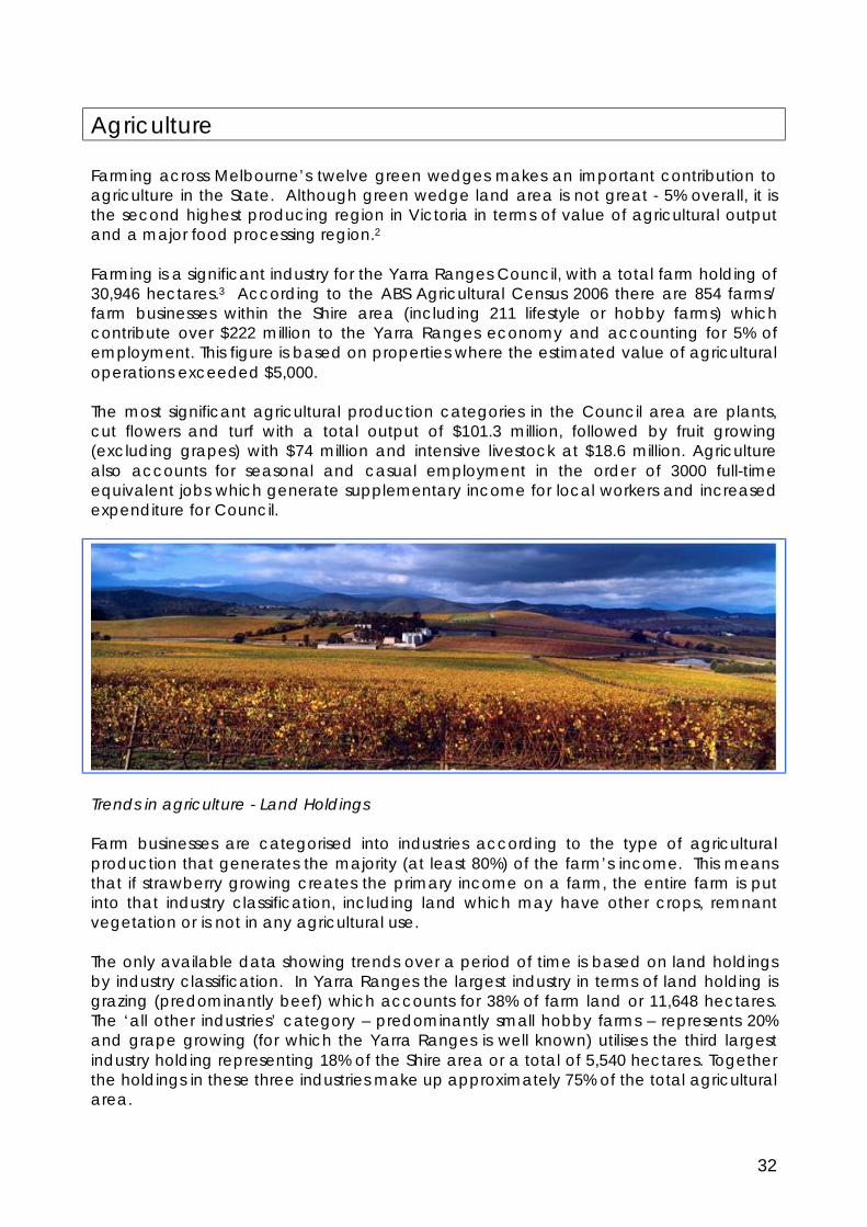
Agriculture
Farming across Melbourne’s twelve green wedges makes an important contribution to agriculture in the State. Although green wedge land area is not great - 5% overall, it is the second highest producing region in Victoria in terms of value of agricultural output and a major food processing region.2 Farming is a significant industry for the Yarra Ranges Council, with a total farm holding of 30,946 hectares.3 According to the ABS Agricultural Census 2006 there are 854 farms/ farm businesses within the Shire area (including 211 lifestyle or hobby farms) which contribute over $222 million to the Yarra Ranges economy and accounting for 5% of employment. This figure is based on properties where the estimated value of agricultural operations exceeded $5,000. The most significant agricultural production categories in the Council area are plants, cut flowers and turf with a total output of $101.3 million, followed by fruit growing (excluding grapes) with $74 million and intensive livestock at $18.6 million. Agriculture also accounts for seasonal and casual employment in the order of 3000 full-time equivalent jobs which generate supplementary income for local workers and increased expenditure for Council.
Trends in agriculture - Land Holdings Farm businesses are categorised into industries according to the type of agricultural production that generates the majority (at least 80%) of the farm’s income. This means that if strawberry growing creates the primary income on a farm, the entire farm is put into that industry classification, including land which may have other crops, remnant vegetation or is not in any agricultural use. The only available data showing trends over a period of time is based on land holdings by industry classification. In Yarra Ranges the largest industry in terms of land holding is grazing (predominantly beef) which accounts for 38% of farm land or 11,648 hectares. The ‘all other industries’ category – predominantly small hobby farms – represents 20% and grape growing (for which the Yarra Ranges is well known) utilises the third largest industry holding representing 18% of the Shire area or a total of 5,540 hectares. Together the holdings in these three industries make up approximately 75% of the total agricultural area.

33
A comparison of land holdings between 1994 and 2006 shows some change in the major agricultural industries. Land devoted to the grazing industry fell by nearly 7,900 hectares or 40% since 1994, while holdings in the grape growing industry grew from 949 hectares to 5,540 in the same 12 year period. Vegetable and nursery growing areas also shrunk substantially by 83% and 43% respectively from 1994 to 2006. Because data is only available for ‘industry holdings’ these figures give only a general view of emerging trends. The statistics for actual cropped or actively used agricultural land (2001 and 2006 data only) present a more constant picture with losses in one area generally offset by increases in another. One notable change over the five years was land in berry fruit production. which jumped from 393 hectares to 584 hectares which represents 79 percent of the State’s total value. Farming will undoubtedly continue to adapt to climate and market changes but the important thing is for Council to ensure it is also responsive and adaptable to the industry’s needs. From a Green Wedge perspective, the crucial information is the total land held in agricultural production. The chart below illustrates total farm holdings between 1994 and 2006 excluding the ‘all other industries group’ or hobby farms. Over this period, total farm holdings, in both active agricultural production and land with the potential to be put into production, decreased by 6851 ha or 22%. The data cannot provide a clear picture of what happened to the 22% of agricultural land no longer in farm holdings. One theory is that this has effectively been converted to rural residential use. However, as no data exists for the rural residential category before 2006, it is difficult to determine if the reduction in farm holdings results from an increase in hobby or life style properties. However, anecdotal information and the popularity of ‘tree change’ properties would suggest that this may be the case.
Chart 2: Area of Holding Trends for Agricultural Industriesin Yarra Ranges Shire
-
5,000
10,000
15,000
20,000
25,000
30,000
35,000
1994 1997 2001 2006
Year ending June 30th
Hec
tare
s
Dairy Farming Fruit Growing (excl Grapes) Grain, Sheep and Beef Farming
Grape Growing Intensive Livestock Farming Nurseries, Cut Flowers and Turf Growing
Other Crop Growing Other Livestock Farming Vegetable Growing

34
Value of production As stated earlier in nominal terms the value of agricultural production within the Council boundary in 2006 was approximately $222.6 million. The nursery and cut flower industry accounts for almost half the total production value and uses only 4.3% of agricultural land area and fruit growing (excluding grapes) produces 32% of total value from only 10.4% of the land. Overall between 1994 and 2006 the total value of production (adjusted for inflation) was up 92% so it seems the extent of actively farmed areas is getting smaller but the total production value from these areas is increasing.
Future of Farming Agriculture in Yarra Ranges has many advantages because of its proximity to the Melbourne market, the “Yarra Valley” brand for fine wines and healthy food, and ‘wine and food’ based tourism. However there are also serious challenges resulting from increasing land values, water shortages, bio-security, labour shortages and conflicts with amenity of rural life stylers. The nature of farming is also changing due to technology, new markets, global economics, and consumer demand. Today’s consumer wants fruit, vegetables and flowers that are ‘perfect’ and often organically grown produce and meat. The market is no longer content with seasonal availability, as shops and restaurants demand a variety of produce year round. Climatic change is also affecting the security and long
Value of Production by Industry Yarra Ranges Shire - 2006
Total Value: $222.6 million
3,005,393
73,994,381
9,459,574 7,087,652
18,652,520
101,330,135
9,079,268
Dairy Farming Fruit Growing (excl Grapes) Grain, Sheep and Beef Farming Grape Growing Intensive Livestock Farming Nurseries, Cut Flowers and Turf Growing Other Crop Growing Other Livestock Farming Vegetable Growing

35
term viability of agricultural production. The current drier conditions - which may be long-term - mean that access to reliable water supplies has assumed much greater importance than previously. It also means that the Yarra Ranges Green Wedge will increase in importance as some inland areas become more marginal for agriculture. The look of agriculture is also changing as more innovative technologies are embraced. Once intensive agriculture was dependent on soil quality - such as the red soils of the Silvan-Monbulk area but increasingly growers are utilising out of soil technologies. The new face of agriculture and horticulture will be increasingly industrial with controlled environments to reduce evaporation and simulate 24 hour growing conditions. Environmental covers to protect crops from frost, hail and heat may feature prominently in the landscape. The use of frost fans has also increased. Trends in broadacre grazing land will also change as cattle feed is controlled to reduce methane emissions, resulting in a feedlot approach. The future of local agriculture is difficult to predict given questions about climate change, transport costs, consumer demand and technology but one thing is clear, the emphasis in Yarra Ranges must continue to be on sustainable agriculture. Planning controls and Council policy will need to be flexible to accommodate and facilitate rapidly changing agricultural technologies designed to improve sustainability. Issues The challenges to farming in the Green Wedge continue to be greater than in other rural areas. The diverse range of competing demands on the area has lead to increased pressures from rural dwellers for regulation of farming activities. The attraction of the area for residential, tourism and recreational uses has also increased land values. Given this Plan focuses on outcomes that are within Council’s ability to deliver or advocate for change. The following specific matters have been raised:
§ Agricultural and landscape management - the increasing intensity of agricultural
operations - often resulting from a rural industry being added to a farm - requires larger farm structures (fruit packing houses, cool stores or wine processing). Alternatively there is need for centralised facilities - independent of growing operations - to be located in the Green Wedge. The large structures needed to house these facilities can result in significant landscape impacts and are subject to planning permits. Other sustainable agricultural practices such as the use of environmental covers are also attracting planning permits to assess their landscape impacts. The agricultural community has expressed a desire to streamline the planning processes to accommodate these changes.
§ Farm Gate/ Cellar Door Sales – from an economic development perspective,
Council wishes to support the sale of agricultural produce as a means of supplementing the viability of local agriculture. State planning policy prohibits farmers selling all but primary produce (unprocessed fruit, vegetable etc. Further all produce must be grown on the land from which it is sold or adjacent land). Any value added sales are classified as a ‘retail’ use which is prohibited in the green wedge zones. The exception is wineries which are allowed to sell retail vineyard products and food and drink for consumption on site. These regulations seem to disadvantage other agricultural producers by restricting them from selling their value added produce on site.
36
§ Accommodation for seasonal workers – sectors of the agricultural industry have expressed ongoing concern at the lack of available workforce to meet the demands of the harvest period. In 2005 the Centre for Agriculture and Business, Yarra Valley (CAB) commissioned a report specifically on the role of backpackers and transient workers in the horticultural industry and their accommodation and transport requirements. CAB is responsible for the implementation of this report and many key recommendations have been completed with the support of the Council’s agribusiness officer, including a prospectus for development opportunities for budget accommodation. From a planning perspective, the zone provisions do enable permits to be granted for seasonal worker accommodation. However, most forms of budget residential development attract concerns from the community in relation to local amenity, traffic, environmental and/or social impacts and approval processes can be protracted and costly.
§ Planning Information – the agricultural community has requested more information
on planning processes and what requires a planning permit. The CAB living in the region subcommittee has suggested during consultation that information sheets regarding planning application processes, vegetation removal and structures in the green wedge area would be helpful.
§ Climate change & Food Security – Volatile weather conditions in recent years
coupled with projections of increased climate instability have reinforced the role of the Yarra Valley as a long term agricultural resource. Council is participating in a study conducted by the Victorian Local Governance Association (VLGA) on Food Security. Food security is defined as, ‘the availability of nutritious and safe food that is accessible to all, for a reasonable price, on a regular basis.’ Despite a general trend towards drier seasons, the Yarra Ranges Green Wedge offers relatively high and regular rainfall, productive soils, and an established agricultural infrastructure all within close proximity to the Melbourne Metropolitan area. Council has a responsibility to ensure that areas of productive agricultural capability are not squandered through inappropriate land use and development.
§ Water recycling – Yarra Ranges is well placed to be a model for sustainable water
use because there are four sewerage treatment plants in the area which produce a significant amount of recycled water suitable for certain types of agriculture (or golf courses). Council is currently working on a project with Yarra Valley Water to promote the use of this recycled water.
§ Current Council programs - Council supports agriculture through a variety of
mechanisms discussed earlier in this report including applying the urban farm land rating to intensive agricultural properties, supporting the Centre for Agriculture and Business and landcare activities and employing an agribusiness officer. It is imperative that Council continues to encourage and support land management programs that promote sustainable land management practices including protecting waterways, revegetation and soil conservation measures.
§ Planted vegetation issues – an ongoing issue relates to the matter of vegetation
planted for land management purposes (such as wind rows) and permit requirements to later remove this vegetation to accommodate new crops etc. (Important: This is not planting required as a permit condition or as a vegetation offset requirement) The farming community have acknowledged that they deliberately avoid planting native or permit controlled vegetation because they don’t want to have to obtain a planning permit should they wish to remove it. This

37
attitude is counter productive to achieving Council’s policy of encouraging the planting of native vegetation that may be better suited to the local conditions, are not invasive and assist in ecological processes.
38
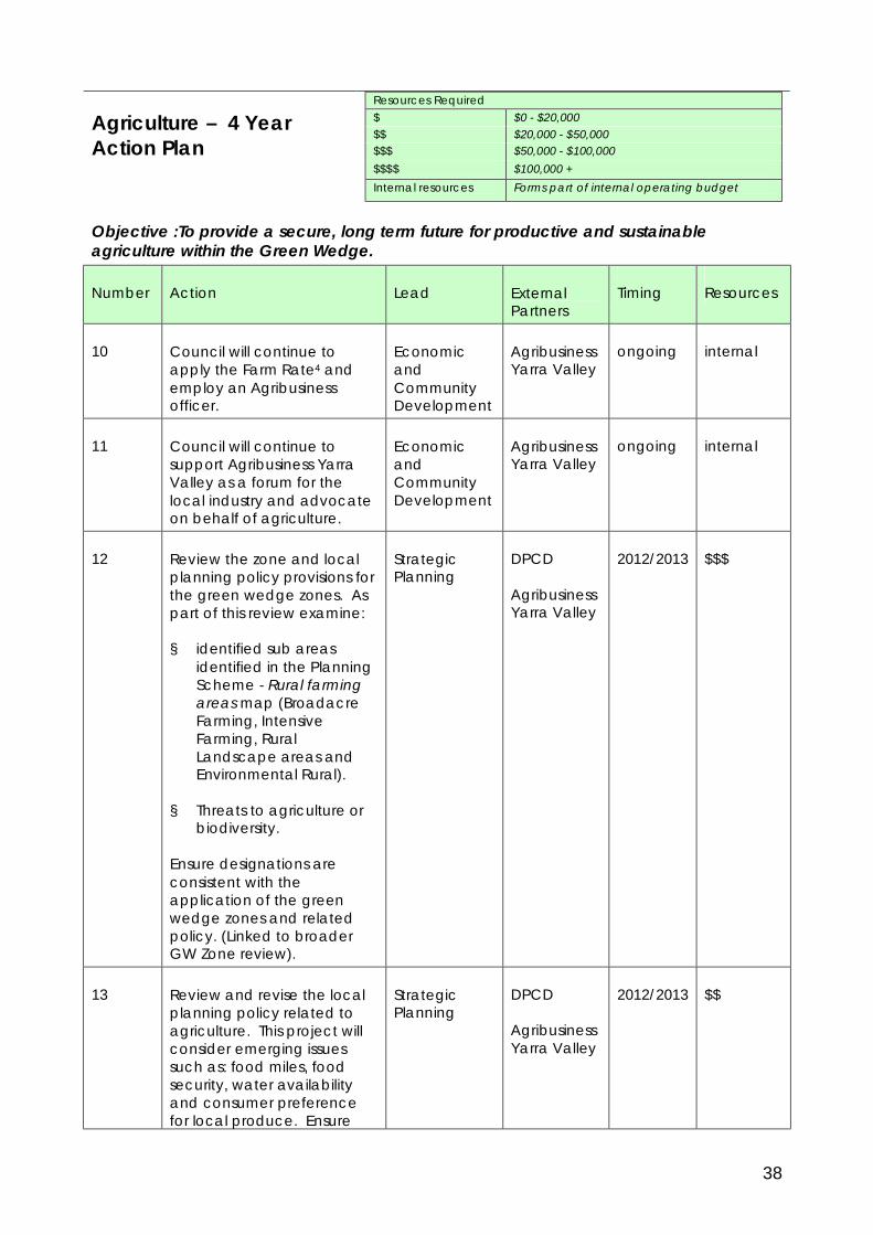
Agriculture – 4 Year Action Plan
Resources Required $ $0 - $20,000 $$ $20,000 - $50,000 $$$ $50,000 - $100,000 $$$$ $100,000 + Internal resources Forms part of internal operating budget
Objective :To provide a secure, long term future for productive and sustainable agriculture within the Green Wedge.
Number Action Lead External Partners
Timing Resources
10 Council will continue to apply the Farm Rate4 and employ an Agribusiness officer.
Economic and Community Development
Agribusiness Yarra Valley
ongoing internal
11 Council will continue to support Agribusiness Yarra Valley as a forum for the local industry and advocate on behalf of agriculture.
Economic and Community Development
Agribusiness Yarra Valley
ongoing internal
12 Review the zone and local planning policy provisions for the green wedge zones. As part of this review examine:
§ identified sub areas identified in the Planning Scheme - Rural farming areas map (Broadacre Farming, Intensive Farming, Rural Landscape areas and Environmental Rural).
§ Threats to agriculture or biodiversity.
Ensure designations are consistent with the application of the green wedge zones and related policy. (Linked to broader GW Zone review).
Strategic Planning
DPCD
Agribusiness Yarra Valley
2012/2013 $$$
13 Review and revise the local planning policy related to agriculture. This project will consider emerging issues such as: food miles, food security, water availability and consumer preference for local produce. Ensure
Strategic Planning
DPCD
Agribusiness Yarra Valley
2012/2013 $$

39
Number Action Lead External Partners
Timing Resources
planning controls seek to maintain a sustainable farming sector.
14 Advocate to State Government to consider sale of value added products in green wedge zones or modifying definitions to allow expanded farm gate sales.
Strategic Planning
DPCD
Agribusiness Yarra Valley
2011 internal
15 Review planning policy to support the provision of accommodation for seasonal workers. (Backpacker or Budget.)
Strategic Planning
2012/2013 internal
16 Develop Council policy position and related design guidelines for agricultural structures in the landscape. Examples include hail netting large sheds and rural industrial buildings.
Revise Horticultural Structures policy and produce information sheets as needed to clearly establish Council’s priorities and processes.
Strategic Planning/ Planning Services
2011- 2013
$$
17 Review and amend existing local laws regulating noise levels from (noise generating) bird deterrents having regard to amenity impacts to humans and threatened faunal species.
Prepare information, guidelines and web based resources for agribusiness and rural residents on the responsible use of devices with amenity impacts such as bird scaring devices, frost fans and other rural industries.
Environmental Health/ Environment
EPA 2011 $$$
18 Work with water authorities to increase the use of recycled water in
Economic Development
Melbourne Water/ Yarra Valley
ongoing internal

40
Number Action Lead External Partners
Timing Resources
agriculture. Water
19 Develop/improve planning information sheets on common agricultural and rural planning permits.
Planning Services
2012/2013 $$
20 Introduce a mechanism to maintain a record of planted native vegetation such as shelter belts, agroforestry, etc for the purpose of exempting registered land owners from planning permits. These permits would be associated with a whole farm plan and address future lopping or removal of planted vegetation.
Explore the suitability of issuing planning permits for whole farm/ or farm management plans. These could identify vegetation removal, dams etc.
Strategic Planning
Planning Services
2014/2015 $$
Note: The funding and timing of all projects will be subject to approval through Council’s annual budget process. All planning scheme changes will be subject to the statutory process for planning scheme amendments, including public consultation outlined at Part 3 of the Planning and Environment Act 1987. DPCD – Department of Planning and Community Development EPA – Environment Protection Agency - Victoria

41
Biodiversity The Green Wedge is part of the Yarra and Dandenong Ranges bioregion characterised by hills, extensive forest cover and high rainfall. Much has been written about the fauna and flora of Yarra Ranges; its biodiversity is one of the most treasured assets. National parks and state forests cover vast tracts of land and approximately half of the Shire has been identified as being of high botanical or zoological significance. Some 1432 indigenous plant species have been recorded of which 112 are listed as rare or threatened and six species are nationally significant for example the Buxton Gum and the Maroon Leek Orchid.
Photo of Buxton Gum: 1, 3, 4 Marilyn Gray ©; 2 Peter Kinchington ©
Yarra Ranges Council area is also home to 408 fauna species of which 92% or 375 are indigenous to the Shire. 62 are listed as Rare or Threatened in Victoria and 41 are listed as nationally significant under the Environment Protection and Biodiversity Conservation Act 1999 including the Helmeted Honeyeater, and Leadbeaters Possum. Flora and Fauna Issues Despite many initiatives to protect threatened species and habitat, it is evident that biodiversity continues to decline. While seemingly insignificant, the cumulative effect can be substantial. Although the Shire still retains extensive areas of forest in protected water catchments and national parks, much of the indigenous vegetation has been reduced to isolated remnant patches on private land with fragmented strips along roadsides and watercourses. With projections of ongoing climate variability, wildlife populations within these remnants are likely to be further threatened through droughts, fires and other calamitous events. Council can enhance the adaptability and viability of its flora and fauna by retaining a diversity of well managed habitat areas and providing connectivity between them. There are a number of specific areas that Council can address to improve local biodiversity. § Biodiversity mapping – The single most critical issue for Council is to obtain current
information on existing biodiversity. Council needs accurate and current data on the location, quality and significance of the flora and fauna habitats on both public and private land. The Yarra Ranges Planning Scheme contains Environmental Significance Overlays which recognise sites of botanical and zoological significance. However they are based on outdated data and provide

42
an incomplete coverage of the Shires significant wildlife habitats. Updated biodiversity mapping is essential to properly identify priorities for protection of significant habitat areas and actions to enhance habitat linkages between them. It will also lead to improved impact assessments of development proposals through better informed planning controls.
§ Bushland management - the management and maintenance of Council’s
reserves, many of which contain remnant vegetation needs to be considered strategically. Council has over 600 reserves in its care - both within the Green Wedge and in the urban areas - many containing remnant vegetation. A potential outcome of the biodiversity mapping project (above) is to use this data to develop a Bushland Reserves Strategy to prioritise work and resources to the most significant areas.
§ Net Gain - the State-wide approach to the management of native vegetation
was set out in a ‘Framework for Action 2002’. The Framework introduced a three step approach to achieving a net gain in the State’s biodiversity by implementing the following: avoid, minimise and offset. Vegetation ‘offsets’ (replacement of vegetation by replanting elsewhere) are required where it can be demonstrated that no other course of action is possible.5 Council is currently developing an internal Biodiversity Offsets Program to assist permit holders to achieve offsets within the municipality. As part of this project vegetation policy in the Planning Scheme needs to be modified to ensure offsets are undertaken within the Shire area and applied strategically to enhance key habitat areas and linkages between them.
§ Weeds – Council’s Weed Management Strategy recognises that pest plants
(weeds) represent the greatest significant threat to the extent and health of indigenous flora and fauna populations and should be controlled. This Strategy states that ‘weed populations have reached an ‘explosive stage’ and are now rapidly expanding especially in the Dandenongs. Remnant patches of bushland/forest are extremely prone to ‘edge effect’ weed invasion and the majority of these remnant areas are on private land.
§ Waterways - the waterways of the Shire traverse both public and private land.
Many contain the only remnants of indigenous flora and fauna in the settled areas and provide important opportunities for linkages between key habitat areas. Excessive stormwater flows, nutrient loads and other contaminants seriously reduce the habitat and amenity values of these waterways. Waterways must be managed to ensure their health as well as function and support for other natural resources.
Land Management Parks Victoria manages over 86,600 hectares of public land in the Shire including the Kinglake, Dandenong Ranges and Yarra Ranges national parks and with Council is working to achieve management of pest plants and animals on the public land within the Green Wedge. The areas of public land are vast and therefore share extensive boundaries with private land holdings. It is critical this interface is well managed to reduce pest plants and animals.

43
Council owns approximately 1000 hectares of the Green Wedge which - although not insignificant -constitutes less than 1% (.42 of one percent) of the total land mass. The following graph illustrates the importance of protecting, managing and enhancing environmental values and in particular controlling weeds on private land which makes up the remaining 36% of land area. Council must engage landholders as long term custodians if sustainable land management is to occur.
Land Ownership in Green Wedge (ha)
Crown Land 151,228.24
64%Council Land
999.320%
Private Land 86,682.88
36%
Crown Land Council Land Private Land
Sustainable land management results from a greater understanding of natural resources, improved land productivity, creating greater social awareness and participation amongst landholders and community. Sustainable land management is defined as: § improvement to -rather than merely maintenance of - private properties and § maintaining or increasing production while at the same time protecting the
environment. Council currently contributes to sustainable land management through a combination of measures (see Management – Incentives, Programs and Education). Many of Council’s land management initiatives are contained in the Yarra Ranges Environment Strategy (2008) and will be strengthened over time through the implementation of the Fauna and Flora Strategy, Land and Waterways Management Strategy, Landcare Programs and the Environmental Compliance Action Plan. Council will continue to carry out current land management activities including: § Managing council owned land, including roadsides, bushland reserves and
public open spaces. § Protecting and enhancing the natural environment through a range of
regulatory, educational, leadership and advocacy mechanisms. § Providing a range of services and support to the Yarra Ranges community
(residents, households, groups, schools, businesses, organisations, landowners and industry etc) that encourage the adoption of good environmental practices.
§ Advocating on behalf of the Yarra Ranges community to other government agencies for good environmental outcomes.
Ground Water All sources of water, including stormwater and groundwater supplies are scarce and high value natural resources. Groundwater (like surface water) is an important and limited source of water and should be considered carefully before harvesting. As a consequence of continued drought, the water table is not being replenished and landowners, faced with water restrictions, are increasingly seeking permits to sink bores

44
on their properties to provide water for personal use. Consideration must be given to the protection of ground water. Waterways and Stream Flow All waterways, whether permanent or seasonal, on both public and private land are important elements in the overall system of environmental health within the Shire area and need to be managed to ensure their healthy functioning and supporting role for other natural resources. Council is working with landowners and water agencies to take a proactive approach to incorporate best practices in stormwater management and encourage use of rainwater tanks, water gardens and other water sensitive designs into buildings particularly in the rural areas. Council also participates in Stream flow management committees and is working with agricultural producers to explore the benefits of off stream dams. Water Supply Catchments Water supply catchments are areas of land that drain into reservoirs or rivers which supply drinking water. Most of Melbourne’s drinking water is sourced from catchments located in the Yarra Ranges Council area, which include both public and private land. Safe drinking water is essential to life and, every effort needs to be taken to ensure that drinking water is safe to use. Melbourne is one of five cities in the world with protected water catchments. The foresight of our city founders in putting aside land for catching and storing water has given us a fantastic legacy. The forested (closed) catchments are located east of Healesville and Warburton and have supplied Melbourne with drinking water over many years. Parts of them are now National Parks managed by Melbourne Water and Parks Victoria and have remained largely undisturbed for more than 100 years, preserving the biodiversity of the ecosystem. However, approximately 30% of water harvested for Melbourne’s water supply is sourced from open catchments, where land is privately owned and not protected by public assets. In Yarra Ranges water is pumped from the Yarra River at Yering Gorge into the Sugarloaf Reservoir to be treated at the Winneke Water Treatment Plan in Christmas Hills. The catchment area at the pumping location is essentially upstream of Yerring Gorge or all of the Yarra Ranges Green Wedge and is called the Mid Yarra Catchment. Consequently catchment management in the Green Wedge is critically important, particularly given that during drought, the Winneke Water Treatment Plan can supply up to half of Melbourne’s drinking water. The area outlined in red in the map below shows the Mid Yarra Catchment. The areas which appear in green hatched pattern are privately owned land within the Green Wedge zones. The pale blue areas are land in public ownership.

45
Mid Yarra Catchment
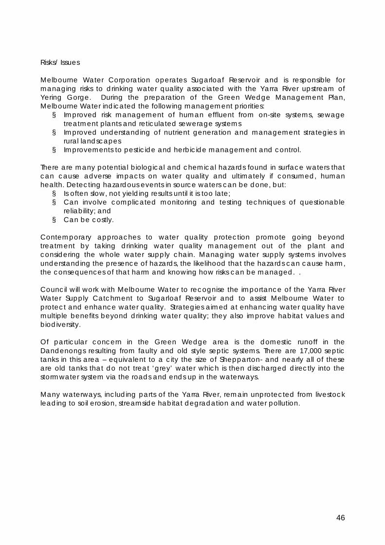
46
Risks/ Issues Melbourne Water Corporation operates Sugarloaf Reservoir and is responsible for managing risks to drinking water quality associated with the Yarra River upstream of Yering Gorge. During the preparation of the Green Wedge Management Plan, Melbourne Water indicated the following management priorities: § Improved risk management of human effluent from on-site systems, sewage
treatment plants and reticulated sewerage systems § Improved understanding of nutrient generation and management strategies in
rural landscapes § Improvements to pesticide and herbicide management and control.
There are many potential biological and chemical hazards found in surface waters that can cause adverse impacts on water quality and ultimately if consumed, human health. Detecting hazardous events in source waters can be done, but: § Is often slow, not yielding results until it is too late; § Can involve complicated monitoring and testing techniques of questionable
reliability; and § Can be costly.
Contemporary approaches to water quality protection promote going beyond treatment by taking drinking water quality management out of the plant and considering the whole water supply chain. Managing water supply systems involves understanding the presence of hazards, the likelihood that the hazards can cause harm, the consequences of that harm and knowing how risks can be managed. . Council will work with Melbourne Water to recognise the importance of the Yarra River Water Supply Catchment to Sugarloaf Reservoir and to assist Melbourne Water to protect and enhance water quality. Strategies aimed at enhancing water quality have multiple benefits beyond drinking water quality; they also improve habitat values and biodiversity. Of particular concern in the Green Wedge area is the domestic runoff in the Dandenongs resulting from faulty and old style septic systems. There are 17,000 septic tanks in this area – equivalent to a city the size of Shepparton- and nearly all of these are old tanks that do not treat ‘grey’ water which is then discharged directly into the stormwater system via the roads and ends up in the waterways. Many waterways, including parts of the Yarra River, remain unprotected from livestock leading to soil erosion, streamside habitat degradation and water pollution.

47
Biodiversity – 4 Year Action Plan
Resources Required $ $0 - $20,000 $$ $20,000 - $50,000 $$$ $50,000 - $100,000 $$$$ $100,000 + Internal resources Forms part of internal operating budget
Objective - To protect and enhance indigenous flora and fauna and habitat within the Shire. Number Action Lead External
Partners Timing Resources
Flora and Fauna 21
To develop and maintain detailed knowledge about the extent, nature and quality of flora and fauna species and habitats in the Shire as a basis for management controls. This will include: § An updated biodiversity
mapping system, consistent with the DSE framework for Ecological Vegetation Classes and Bioregions and that can consider links and buffers.
§ A system that can be progressively added to and updated over time.
§ Use this data to inform decisions on planning permit applications.
Environment Strategic Planning Planning Services
DSE/ DPCD
2011 through 2015
$$$$
22 Review all vegetation controls to maintain and enhance core environmental values. § Develop a revised
Environmental Significance Overlay,
§ local planning policy and § Modify vegetation
provisions to enhance existing provisions including connectivity and other strategic considerations.
Environment/ Strategic Planning
DSE / DPCD
2012 through 2015
Internal and included in funding action 21.
23 Develop an internal Biodiversity Offsets Program to assist permit holders to achieve offsets within the municipality.
Environment 2010/2011
Internal + $$
24 Continue to implement the actions in the Weed Management Strategy to reduce the impact of weeds in the Shire.
Environment and Engineering
DSE Melbourne Water
ongoing Internal and as budgeted
25 Work with Parks Victoria, public Environment DSE Ongoing internal

48
Number Action Lead External Partners
Timing Resources
agencies, Landcare networks and landowners in the Green Wedge to achieve more effective land management.
Melbourne Water Parks Victoria
26 Prepare information and advice sheets for landowners to address weed management.
Environment ongoing $$
Ground Water 27 Advocate to Southern Rural
Water to sustainably manage permits for additional bores within the municipality.
Strategic Planning
Southern Rural Water
2011 internal
Waterways and Stream Flow 28 Support and promote
Melbourne water programs that educate landowners to protect waterways by greater use of recycled water and reduced nutrient inputs into waterways.
Environment/ Environment and Engineering
Melbourne Water/ Yarra Valley Water/ South East Water
Ongoing Internal and as per budget
29 Investigate the application of an Environmental Significance Overlay for major waterways to encourage sustainable land management and protect habitat links.
Strategic Planning
DPCD 2011- 2013
$$$
30 Advocate to water authorities to review the criteria for issuing permits for dams to ensure there is no significant adverse impact on stream flows to tributaries and the greater catchment area.
Melbourne Water, Southern Rural Water, Yarra Valley Water
2012 internal
Water Quality 31 To recognise, protect and
enhance the quality of water in the Yarra River. Work with Melbourne Water to prepare a catchment management plan for the Yarra River Water Supply Catchment to Sugarloaf Reservoir.
Environment Strategic Planning
Melbourne Water
Ongoing $$$
32 Analyse land use and development within the catchment to identify risk to drinking water quality § review of the planning
provisions and policy to ensure appropriate recognition of the importance of protecting water quality
Strategic Planning
Melbourne Water/ Yarra Valley water
2010- 2015
internal

49
Number Action Lead External Partners
Timing Resources
§ prepare action plan (including funding principles) to direct catchment management activities toward drinking water quality priorities.
33 Review current planning policies and strategies for managing land use and development within the catchment.
Strategic Planning
Melbourne Water/ Yarra Valley water
2011 -2015
$$ + internal
34 Complete a Domestic Wastewater Management Plan. The plan will § commit all agencies to a
realistic timetable to eliminate the local sewerage backlog and
§ contain strategies to improve the management of on-site domestic wastewater systems where sewer systems will not be provided.
Adopt measures to encourage landowners to connect to the sewer.
Environmental Health
Water Agencies
ongoing $$ + internal
Note: The funding and timing of all projects will be subject to approval through Council’s annual budget process. All planning scheme changes will be subject to the statutory process for planning scheme amendments, including public consultation outlined at Part 3 of the Planning and Environment Act 1987. DSE – Department of Sustainability and Environment DPCD – Department of Planning and Community Development

50
Landscape Management ‘Yarra Ranges is a municipality that straddles the urban/rural interface in a location where one of the State’s most attractive and significant landscapes meets the edge of the metropolitan area. It’s varied landscapes ranging from mountain forests to cultivated, pastoral valleys are a major attraction for residents and visitors.’6 However, change is occurring in the landscape. Additional dwellings, tourist facilities and associated vegetation removal all impact the green wedge landscape. Additionally, the nature of the agricultural landscape is changing in line with new farming practices and a shift from broadacre grazing to more intensive agriculture. The beauty of the landscape itself attracts more development, creating additional pressure as more and more development locates in the Green Wedge. The planning framework addressing landscape protection needs to recognise these inevitable changes and manage them.
Issues Council needs a clearly articulated policy on the management of its significant landscapes; that will maintain and enhance them through progressive change. Many of the most important landscapes were designated in the Yarra Ranges Planning Scheme by a Significant Landscape Overlay (SLO) which outlines 21 valued landscape types. These landscapes were identified through assessments undertaken by the National Trust of Australia (Victoria) in 1982. While the landscapes originally identified by the National Trust have generally retained their significance, there remain extensive rural areas of the Shire which have no formal recognition of their landscape values. Existing planning controls require planning permits for most new development in green wedge areas; however they rely on landscape assessment work undertaken over 25 years ago. This coupled with the lack of well targeted design guidelines, has limited the effectiveness of the current permit controls to protect the valued landscapes from obtrusive development. To address these issues, Council commissioned a report, completed in May 2008, entitled Vision 2020 by Design. The report, adopted by Council in April 2009, provides a comprehensive assessment of design issues throughout the Green Wedge. It includes an analysis for each of five identified rural landscape character types. The report
51
recommends development guidelines specific to each of these landscape character types. The principle rural landscape types are described in Vision 2020 by Design as below and are illustrated on the map that follows: § Dandenong Ranges Landscape Type – the Dandenong Ranges are the most
prominent and substantial hills close to Melbourne, with dense forested scenery and intimate fern gullies that have attracted day trippers since white settlement. They provide an iconic backdrop to most long distance views across Melbourne’s eastern suburbs. Kalorama, Olinda, Ferny Creek and Kallista
§ Red Soil Intensive Agricultural Landscape Type – The Red Soil Intensive Agricultural
areas are the intimate patchwork of intensive cultivated hills and vales that extend from the Silvan Reservoir to the Woori Yallock and Cockatoo Creeks. Includes areas around Silvan, Wandin and Monbulk
§ Rolling Agricultural/ Bushy Agricultural Landscape Type – are the broad acres of
pleasantly undulant land with mountain backdrop, partly forested but mainly cultivated. Includes areas around Yellingbo, Seville, Hoddles Creek, Macclesfield, Gruyere, Warramate Hills and Dixons Creek.
§ Open Valleys Landscape Type – are pastoral plains with gentle topography
centred around the Yarra River floodplain, bordered by the slopes and foothills of the adjoining Ranges. Includes areas around Yarra Glen and Healesville.
§ Yarra Ranges Valleys Landscape Type – extends along the valley floors of the
Yarra River and the Little Yarra River, enclosed by long steep forested slopes. The area is largely undeveloped with a range of rural/pastoral uses with large stands of remnant native vegetation. Includes areas around Don Valley, Woods Point, Yarra Junction- Noojee Road.7
Vision 2020 by Design provides the basis for a comprehensive revision of the planning scheme policies and controls that currently seek to address landscape management issues. It also will enable Council to prepare design guidelines and information sheets to explain to the public what - in Council’s view - is acceptable for buildings and works in the Green Wedge. The issue of rural landscape management is particularly important to the agricultural community as discussed in earlier sections as some new farm technologies and trends in agriculture can have serious impact on the landscape. See Project Plan 3.

52

53
Landscape Management
4 Action Year Plan
Resources Required $ $0 - $20,000 $$ $20,000 - $50,000 $$$ $50,000 - $100,000 $$$$ $100,000 + Internal resources Forms part of internal operating budget
Objective –To protect and enhance the scenic qualities and rural landscapes of the Green Wedge for the benefit of the local and wider community. Number Action Lead External
Partners Timing Resources
35 Review the coverage and content of landscape protections controls set out in the Planning Scheme. (Significant Landscape Overlays and permit triggers under Clause 53) in accordance with Vision 2020 by Design and prepare a planning scheme amendment to implement changes. § Ensure the policy is
unambiguous and addresses issues and planning considerations.
Strategic Planning Planning Services
DPCD 2010-2012
$$
36 Investigate a policy position for agricultural structures to provide guidance to the agricultural community on their use in areas of landscape significance. Explore the possibility of a Code of Practice/ Local Planning policy for environmental covers/ hail netting or other similar structures.
Strategic Planning Planning Services
DPCD Agribusiness Yarra Valley
2010-2012
internal
37 Develop guidelines and information sheets on the preferred look of buildings in rural areas consistent with Vision 2020 by Design. These guidelines can be used when designing proposed buildings and works which will be subject to planning permits.
Strategic Planning / Planning Services
2012-2013
$$
Note: The funding and timing of all projects will be subject to approval through Council’s annual budget process. All planning scheme changes will be subject to the statutory process for planning scheme amendments, including public consultation outlined at Part 3 of the Planning and Environment Act 1987. DPCD – Department of Planning and Community Development
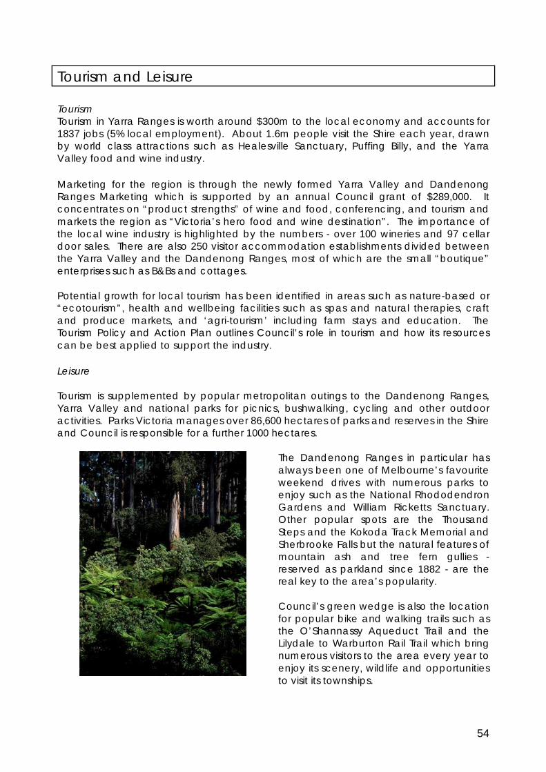
54
Tourism and Leisure Tourism Tourism in Yarra Ranges is worth around $300m to the local economy and accounts for 1837 jobs (5% local employment). About 1.6m people visit the Shire each year, drawn by world class attractions such as Healesville Sanctuary, Puffing Billy, and the Yarra Valley food and wine industry. Marketing for the region is through the newly formed Yarra Valley and Dandenong Ranges Marketing which is supported by an annual Council grant of $289,000. It concentrates on “product strengths” of wine and food, conferencing, and tourism and markets the region as “Victoria’s hero food and wine destination”. The importance of the local wine industry is highlighted by the numbers - over 100 wineries and 97 cellar door sales. There are also 250 visitor accommodation establishments divided between the Yarra Valley and the Dandenong Ranges, most of which are the small “boutique” enterprises such as B&Bs and cottages. Potential growth for local tourism has been identified in areas such as nature-based or “ecotourism”, health and wellbeing facilities such as spas and natural therapies, craft and produce markets, and ‘agri-tourism’ including farm stays and education. The Tourism Policy and Action Plan outlines Council’s role in tourism and how its resources can be best applied to support the industry. Leisure Tourism is supplemented by popular metropolitan outings to the Dandenong Ranges, Yarra Valley and national parks for picnics, bushwalking, cycling and other outdoor activities. Parks Victoria manages over 86,600 hectares of parks and reserves in the Shire and Council is responsible for a further 1000 hectares.
The Dandenong Ranges in particular has always been one of Melbourne’s favourite weekend drives with numerous parks to enjoy such as the National Rhododendron Gardens and William Ricketts Sanctuary. Other popular spots are the Thousand Steps and the Kokoda Track Memorial and Sherbrooke Falls but the natural features of mountain ash and tree fern gullies - reserved as parkland since 1882 - are the real key to the area’s popularity. Council’s green wedge is also the location for popular bike and walking trails such as the O’Shannassy Aqueduct Trail and the Lilydale to Warburton Rail Trail which bring numerous visitors to the area every year to enjoy its scenery, wildlife and opportunities to visit its townships.

55
These parks and trails are of significant value to greater Melbourne as they provide a place for people to get away and get together. Volunteers devote time to work in parks; and conservation, recreation and natural and cultural history groups visit parks. Activities such as these support personal wellbeing, build social cohesion and strengthen the community. Issues Tourism Policy - Council must consider ways to support the growth of tourism without compromising the Green Wedge. Tourist developments that support its primary values of biodiversity, agriculture and landscape should be encouraged. Council will also work with Parks Victoria to promote appropriate tourism and recreation opportunities within the public lands. The State Government’s planning provisions for the Green Wedge restrict much of what can occur. Council policy (derived from the Regional Strategy Plan) and developed prior to the green wedge provisions, is often inconsistent with State policy and there are unintended differences. This creates confusion and uncertainty in the community. The Tourism Policy and Action Plan lists several actions regarding Green Wedge planning controls including: § Standardise definitions for accommodation (bed and breakfast etc), § Review policy for location of tourist facilities and size of land on which a facility
may develop § Review current local planning requirements for uses associated with tourism
developments and consider options for allowing tourist developments in association with biodiversity enhancements.
A general review of tourism policy needs to occur consistent with the adopted vision for the Green Wedge. Accommodating New Golf Courses – the Green Wedge accommodates several golf courses already - Heritage Golf & Country Club and the Croydon Golf Club at Yerring Meadows - but there are currently proposals to develop further golf courses. The Chirnside Park, Waverley and Eastern golf clubs are currently pursuing relocation to sites within the Green Wedge. This appears to be part of a wider trend driven by population growth, urban consolidation policy and financial difficulties of established clubs. As part of the wider review of tourism policy mentioned above, Council should investigate its policy position on major recreation facilities including golf courses. Issues that should be considered include Council’s current requirement (under Clause 53) for recreation facilities to be either in association with agriculture or accommodation. This can lead to recreation facilities providing tokenistic agricultural activity for the sake of overcoming a planning requirement, which may not be the best long term outcome for the site. Special Use Zone – Although opportunity for new developments is constrained by current State Planning provisions, thirteen individual sites of up to 20ha exist that are within the Special Use Zone (SUZ). With the exception of the Balgownie Estate where a SUZ was recently applied by the State Government, these sites are based on site specific provisions that were historically agreed to by the Council at the time. The SUZ allows for uses that would otherwise be prohibited in the Green Wedge zones. The twelve sites are a legacy of earlier planning schemes and depending on the specifics, can offer employment and economic benefit. Unfortunately some of the development

56
proposals would no longer be viable or desirable in the current market environment or from a design aspect and others are vague and confusing ultimately impeding developments. It is proposed that these Special Use Zone sites be reviewed - either collectively or in collaboration with landowners, or on an as needed basis when a landowner approaches the Council or when new circumstances arise. Major Development Proposals - Different people representing a range of interests have asked that the Planning Scheme should be more effective in dealing with conflicting policies. This view has emerged through both the Green Wedge Management Plan process, and through the review of the Local Planning Policy Framework. There is a sense that planning policies and objectives in the Municipal Strategic Statement (MSS) and other policies such as Vision 2020, the Environment Strategy, and the Economic Development Strategy are too even handed and too balanced to the point that they are all things to all people. The Planning Scheme is intended to be policy driven and therefore supports multiple (sometimes conflicting issues). Establishing a clear vision for the Green Wedge through this management plan process will articulate some priorities and will partially resolve this matter. Festivals and Events in Rural Areas – Entertainment and community festivals have become commonplace and are popular in rural areas. They stimulate tourism in the Green Wedge and are also important to many agricultural enterprises especially vineyards and wineries as a way of diversifying income streams. Temporary or one off events generally do not fall within the realm of the Planning Scheme and do not require a planning permit. However a coordinated event management plan would be helpful to organisers to obtain approval from various Council and State agencies addressing (as relevant): traffic management, emergency management, security and crowd control, first aid, public health, amenity issues, food safety, temporary buildings etc. Council currently uses an event management guide developed by Victorian Authorities and Emergency Services to assist in coordinating an event. This comprehensive guide – 65 pages in total – can be cumbersome to use. Council is in the process of preparing a new streamlined event planning manual which will be managed through a single point of contact at Council to provide an easier process for event planning. While not specifically a green wedge issue, this process will assist in green wedge management. Where events become formalised and are scheduled on a regular basis, they are currently interpreted under the Planning Scheme as a ‘Place of Assembly’, which is defined as 'land where people congregate for religious or cultural activities, entertainment, or meetings'. Under the Green Wedge Zone and the Rural Conservation Zone a Place of assembly is prohibited. Rather than a complete prohibition, a more flexible approach is required and events that complement the Green Wedge should be permissible. Any changes to the green wedge zone provisions would need to be undertaken by the State Government.

57

58
Tourism and Leisure – 4 Year Plan
Resources Required $ $0 - $20,000 $$ $20,000 - $50,000 $$$ $50,000 - $100,000 $$$$ $100,000 + Internal resources Forms part of internal operating budget
Objectives:
- To ensure tourism, recreation and leisure activities complement the primary values of the green wedge. - To promote further development of the Shire’s tourism industry in a form that maintains and enhances a healthy environment and nurtures the Shire’s rich cultural heritage. Number Action
Lead External Partners
Timing Resources
38 Review tourism policy statements to ensure they reflect the vision for the Green Wedge – where tourism and recreation play a secondary and complementary role to the primary values of the Green Wedge: biodiversity, agriculture and landscape.
Strategic Planning
DPCD 2011/2012 Internal
39 Work in partnership with Parks Victoria and other public landholders to promote and provide tourism and nature based leisure opportunities.
Economic Development Planning Services
Parks Vic ongoing internal
40 Support and improve the major projects facilitation process to provide timely, considered and coordinated response to proposed major investments.
Economic Development Planning Services
ongoing internal
41 Establish a clear policy position on the development of recreation facilities including golf courses in the Yarra Ranges as part of a broader review of tourism policy.
Strategic Planning
2012-2013 internal
42 Advocate to the State Government to resolve issues associated with planning scheme controls in the Green Wedge. Specifically: § Allow tourism facilities to
be provided in association with enhancement of areas of natural beauty or biodiversity.
§ Clarify land use definitions
Strategic Planning
DPCD, DSE, Parks Victoria
2010/2011 internal
59
Number Action Lead
External Partners
Timing Resources
relating to visitor accommodation.
§ Modify the definition of primary produce sales to allow some value added product.
§ Review definition of Place of Assembly with a view to accommodate some ‘formalised’ events to occur in the green wedge.
43 Review the application of the Special Use Zone in the context of emerging tourism policy and the Green Wedge Vision.
Strategic Planning
Landowners of sites in the Special Use Zone. DPCD
2014/2015 $$
44 Prepare a planning manual to assist the management and operation of community festivals and events. § Develop a code of
practice for events to address amenity issues if this is allowable.
§ Explore whether a local law would be an appropriate method of dealing with amenity issues.
Strategic Planning, Arts Culture and Heritage Public Health
Tourism Alliance Victoria, Yarra Ranges Regional Marketing Local Community Groups
Ongoing internal
Note: The funding and timing of all projects will be subject to approval through Council’s annual budget process. All planning scheme changes will be subject to the statutory process for planning scheme amendments, including public consultation outlined at Part 3 of the Planning and Environment Act 1987. DPCD – Department of Planning and Community Development DSE – Department of Sustainability and Environment

60
Rural Living People want to live in the Green Wedge for many reasons; small-scale farming, ability to own horses, living in a bush land setting or a business which requires a larger property. The ability to live a rural lifestyle close to city services is a luxury and can ultimately compromise and spoil the environmental or agricultural values which originally made it attractive. The protection of green wedge areas from further rural residential development is strongly supported by the State Government’s planning framework, Melbourne 2030. In line with the State’s planning policy, Council’s position on residential development and further subdivision must be to limit opportunities as far as possible in accordance with legislation and natural justice. Issues Rural residential subdivisions -the Green Wedge contains many thousands of small lot rural subdivisions that were mostly created before the introduction of effective planning controls. These subdivisions have resulted in the widespread dispersal of rural residential properties throughout the Green Wedge. Many intermingle with larger properties managed for productive agricultural use. This situation has led to conflicts between the expectations of farmers and others seeking a rural residential lifestyle. Other rural residential subdivisions are concentrated in highly fire prone and environmentally sensitive locations such as the Dandenong Ranges and the upper reaches of the Yarra Valley. The Planning Scheme recognises the land management and servicing issues associated with rural residential development. The introduction of strict subdivision controls based on the Upper Yarra Valley and Dandenong Ranges Regional Strategy Plan has curtailed the creation of new residential subdivisions. Planning techniques such as land buy back programs, subdivision restructure controls and tenement provisions have limited the development of houses on vacant lots created under old rural residential subdivisions. Unfortunately, the State Government has largely withdrawn support for land buy back programs in more recent years. Council has utilised Restructure Overlays in the Planning Scheme and applied them to over 100 old rural residential subdivisions - the program for lot consolidation in these areas is now well advanced. Because of the attractive nature of the land and demand, there continues to be pressure to allow further houses on the remaining vacant lots in Council’s Green Wedge. House entitlements - the current planning scheme presents a confusing array of policies and controls relating to the use of vacant lots for a house. The land use controls for the Green Wedge, Green Wedge A and Rural Conservation Zones - introduced after the creation of the Yarra Ranges Planning Scheme - require a permit for the use of any vacant lot for a house. This has removed any perceived ‘right’ to use vacant lots for a dwelling, although it is still an expectation of many landowners. The current Planning Scheme also contains tenement controls in the Schedule to Clause 53. Tenement controls were initially introduced during the 1980’s as a technique for

61
limiting the number of vacant lots that could be used for a house. They provided each owner of vacant land with at least one dwelling entitlement. However where groups of lots were held by the same landowner, the tenement controls had the effect of allowing only one dwelling on the total landholding or ‘tenement’. Pressure from affected landowners prior to the creation of the Yarra Ranges Planning Scheme resulted in a series of changes to tenement controls. The most significant of these changes were:
• The limitation of tenement controls to only those parts of the Council area that were in the former Shires of Lilydale and Sherbrooke;
• The introduction of permit discretion to allow a house on a tenement subject to compliance with specified assessment criteria.
There are some serious deficiencies with the current tenement controls. These include:
• Inadequate permit assessment criteria which are vaguely expressed and open to broad interpretation;
• The inconsistent coverage of tenement controls across the Council area; • The lack of any clear policy direction for the assessment of house applications on
vacant lots where tenement controls do not apply; • The complexity and questionable equity of requiring permit decisions to be
based on land ownership patterns that existed over 25 years ago; • The tendency for tenement requirements to dominate the assessment of
applications at the expense of the more thorough consideration of issues under the zone based permit control over houses on vacant lots.
A more comprehensive and effective approach to controlling the use of vacant lots for houses would be to utilise the permit controls contained in the zone provisions. This permit control would need to be supported by a clearly expressed local planning policy that incorporated a more thorough range of assessment considerations than the current tenement control. Living in environmentally sensitive and/or farming areas – the differing expectations of rural residents and the ‘right to farm’ are well documented. Similarly, the real and perceived impacts to biodiversity resulting from residential land use (and farming) have also been covered earlier in this report. Clearly the differing expectations of landowners create compatibility issues. More effective control over new dwellings on vacant lots in green wedge areas can help to minimise the further intrusion of rural residential uses into farming areas and areas of environmental significance, although most are already interspersed with rural residential uses. Better publicity and information could manage some expectations, for instance with easy to read brochures about what residents (and tourists) should expect from the different green wedge zone (areas). Council has previously worked with the Centre for Agricultural Business Yarra Valley to produce such brochures8 for agricultural areas but feedback indicates that the information needs to be published and distributed more effectively. Distributing information packages through real estate agents has been explored, however agents are not keen to hand out any information that may discourage a potential buyer.

62
Rural Living – 4 Year Plan
Resources Required $ $0 - $20,000 $$ $20,000 - $50,000 $$$ $50,000 - $100,000 $$$$ $100,000 + Internal resources Forms part of internal operating budget
Objective - To manage rural living in the Green Wedge in a manner which prevents negative impacts on agriculture and biodiversity. Number
Action Lead External Partners
Timing Resources
45 Review the policies and controls relating to the assessment of proposals for houses and vacant rural lots and replace the existing tenement controls with a set of clear and comprehensive policies that: § Are applied in conjunction with
the zone based permit controls. § Strengthen support for
productive agriculture. § Address environmental
concerns and enhance biodiversity.
§ Minimise further intrusion of rural residential into areas of high biodiversity value.
§ Minimise opportunities for further residential development in areas of fire risk, poor access and lack of services.
Strategic Planning Planning Services
DPCD 2011-2015 $$
46 Design a method/process for engaging with rural lifestylers to ensure their opinions are known when policy is being developed.
Community Engagement and Development Strategic Planning
2011 internal
47 Work with local landowners through ‘friends of’ and Landcare groups to improve land management in rural areas.
Environment ongoing internal
48 Review current subdivision provisions to simplify existing controls, in particular. § Review the maximum
subdivision provisions. § Rationalise the number of
schedules to the zones.
Strategic Planning
DPCD 2012/ 2013
internal
Note: The funding and timing of all projects will be subject to approval through Council’s annual budget process. All planning scheme changes will be subject to the statutory process for planning scheme amendments, including public consultation outlined at Part 3 of the Planning and Environment Act 1987. DPCD – Department of Planning and Community Development DSE – Department of Sustainability and Environment

63
Cultural Heritage
Council’s Reconciliation Strategy and Action Plan 2008-2010 contains 5 priority actions for reconciliation. Of particular relevance to the Green Wedge Management Plan is Priority 2 – Acknowledge and protect Indigenous cultural heritage. The following objectives and actions are taken from the Reconciliation Strategy.
Cultural Heritage – 4 Year Plan
Resources Required $ $0 - $20,000 $$ $20,000 - $50,000 $$$ $50,000 - $100,000 $$$$ $100,000 + Internal resources Forms part of internal operating budget
Objective – To acknowledge and respect our Indigenous Heritage Number Action Lead External
Partners Timing Resources
48 Develop a process to better identify and map significant cultural heritage sites within the Shire.
Strategic Planning Services Social Planning
Indigenous Advisory Committee (IAC) Aboriginal Affairs Victoria, Indigenous Communities
Ongoing internal
49 Identify and promote the requirements of the Aboriginal Heritage Act and how it will impact the community.
Strategic Planning Social Planning
IAC, ongoing internal

64
NEXT STEPS Implementation The Strategic Planning department will oversee the overall implementation of this Plan and report on it. The implementation will involve considerable assistance from other Council departments and external partners as noted in the action plans. An important element of this process will be to liaise regularly with the Department of Planning and Community Development. Initially the State Government will need to agree to a process for changing the Yarra Ranges Planning Framework as they are the Responsible Authority for the Regional Strategy Plan. Further DPCD will need to be involved in any new over-arching plans or changes to planning controls affecting the Yarra Ranges Green Wedge. Review This Green Wedge Management Plan will be kept up to date and reviewed regularly by an internal working group. The monitor and review of actions contained in this document will be the responsibility of the Strategic Planning Department. An overall review of progress on the actions contained in the Plan will be undertaken at the two year mark. The review will be reported to Council to determine how well Council is meeting its objectives.
2010 Adoption of the Green Wedge management Plan
Incorporate Policy directions into the Local Planning Policy Framework
2013 Initial progress Review
2010-2015 Implementation process coordinated by Strategic
Planning
Embed the Actions in the Council Plan Establish an agreed
process with the State Government to review the planning framework.

65
APPENDIX 1 ZONES AND OVERLAYS IN THE YARRA RANGES PLANNING SCHEME
ZONE BRIEF DESCRIPTION
Green Wedge Zone
The purpose of this zone is to recognise and protect non-urban land outside the Urban Growth Boundary for its agricultural, environmental, landscape or recreational values. The zone provides a minimum lot size of 40 hectares unless an alternative is specified in a schedule to the zone (six schedules are specified in the Yarra Ranges Planning Scheme). The creation of smaller lots is prohibited except for the re-subdivision of existing lots.
Rural Conservation Zone
This zone is designed to protect and enhance the natural environment for its landscape, faunal habitat and cultural values. Agriculture is allowed provided it is consistent with the environmental and landscapes values of the area. The zone provides a minimum lot size of 40 hectares unless an alternative is specified in a schedule to the zone (three schedules are specified in the Yarra Ranges Planning Scheme). The creation of smaller lots is prohibited unless the subdivision is the re-subdivision of existing lots.
Green Wedge A Zone
The zone provides opportunity for residential development outside of the Urban Growth Boundary. It also provides opportunity for most agricultural uses and limits non-rural uses to those that support agriculture or tourism provided that the amenity of residential living is protected. It seeks to protect and enhance biodiversity, natural resources, scenic landscapes and heritage values and to promote sustainable land management. The zone provides a minimum lot size of 8 hectares unless an alternative is specified in a schedule to the zone (two schedules are specified in the Yarra Ranges Planning Scheme). The creation of smaller lots is prohibited unless the subdivision is the re-subdivision of existing lots.
Public Conservation and Resource Zone eg National parks, state forests etc
This zone applies where the primary intention is to conserve and protect the natural environment or resources. It also allows associated educational activities and resource-based uses.
Public Use Zone eg water catchments
This zone recognises the use of land for a public purpose and prescribes a number of categories of public use which can be shown on the Planning Scheme map. This is the main zone for public land used for utility or community service provision.
OVERLAYS
Environmental Significance Overlay
Environmental significance is intended to be interpreted widely and may include issues such as effects from noise or industrial buffer areas, as well as issues related to the natural environment. The Environmental Significance Overlays for Yarra Ranges identify about half of the Shire as of Botanical or Zoological Significance.
Significant Landscape Overlay
The reasons or characteristics which make up the significance of the landscape identified must be stated, together with the intended outcomes of imposed requirements. Generally, some explanation for the significance of the landscape would be expected in a reference document.
Restructure Overlay This overlay applies a restructure plan to old and inappropriate subdivisions as a condition of development approval. The restructure plan should be an incorporated document because it controls whether or not a permit can be considered.

66
Wildfire Management Overlay
This overlay is applied to areas identified by the Country Fire Authority (CFA) as having high bushfire hazard.
Erosion Management Overlay
This overlay identifies land subject to significant erosion. There should be appropriate technical justification available to support the application of this overlay.
ALLOWED LAND USES IN THE GREEN WEDGE ZONES
ZONE No permit requirement (if relevant provisions are met) Allowed subject to Permit
Green Wedge Zone
Crop Raising, Apiculture, B&B, Mining, Animal keeping, Telecommunications facility, Minor Utility installation, Search for Stone.
Agriculture, Camping and Caravan Park, Dwelling, Exhibition Centre, Function Centre, Group Accommodation, Freezing and Cool Store, Host Farm, Major sports and recreation facility, Market, Plant Nursery, Primary Produce Sales, Place of Worship, Research and Development Centre, Residential Hotel, Restaurant, Rural Industry, Rural Store, Timber Production, Vehicle Store, Winery
Rural Conservation Zone
Animal Keeping, B&B, Minor Utility, Telecommunications, Search for Stone
Agriculture, Community Market, Dwelling, Cool Store, Group Accommodation, Host Farm, Plant Nursery, Primary produce sales, Residential Hotel, Restaurant, Rural Industry, Rural Store, Timber Production, Utility Installation, Winery
Green Wedge A Zone Apiculture, B&B, Mining, Animal keeping, Telecommunications facility, Minor Utility installation, Search for Stone.
Agriculture (including crop raising), Camping and Caravan Park, , Dwelling, Exhibition Centre, Community Marker, Function Centre, Group Accommodation, Host Farm, Leisure and Recreation, Major Sports and Recreation, Place of Worship, Plant nursery, Primary Produce Sales, Research Centre, Residential Building, Restaurant, Rural Industry, Rural Store, Timber Production, Vehicle Store, Winery
RELEVANT LOCAL PLANNING POLICIES
POLICY BRIEF DESCRIPTION

67
Horticultural Structures The policy is designed to support the ongoing sustainability of intensive horticulture in the Shire but limits opportunities for horticultural structures in the form of plastic covered igloos and glasshouses.
Timber Industry The policy aims to support the restructuring of the timber industry and directs major sawmills and timber processing to "preferred development areas" at Powelltown, Launching Place, and South Yellingbo.
Vegetation Protection
The policy recognises the importance of remnant vegetation and applies to proposals to remove vegetation. It contains guidance for the removal of native vegetation, landscape considerations, the re-establishment of native vegetation, and vegetation removal in areas affected by an Environmental Significance Overlay.
1 Statement of Planning Policy 1 applied to the Upper Yarra Valley and Dandenong Ranges under the Town and Country Planning Authority Act 1961. 2 Land Use and Community Food Security in Victoria – Issues Paper; VLGA November 2008 3 Agricultural Profile: Shire of Yarra Ranges, Neil Clark and Associates February 2009. 4 The Valuation of Land Act 1960 defines farm land as: any rateable land – § That is not less than 2 hectares in area; and § That is used primarily for grazing (including agistment), dairying, pig-farming, fish-farming, tree-farming,
bee keeping, viticulture, horticulture, fruit growing or the growing of crops of any kind or for any combination of those activities; and
That is used for a business – o That has significant and substantial commercial purpose or character; and o That seeks to make a profit on a continuous or repetitive basis from its activities on the land and, o That is making a profit from its activities on the land or that has a reasonable prospect of making a
profit from its activities on the land if it continues to operate in the way that it is operating. 5 Victoria’s native Vegetation Management – A Framework for Action, Department of Natural Resources and Environment. 6 Vision 2020 by Design – A Built Environment for Yarra Ranges, Planisphere with Planning Collaborative Pty. Ltd. 2008 7 The area depicted on the map on page 32 as ‘Yarra Ranges Valleys’ type, will be modified to include areas of the Don Valley, in response to submissions to Vision 2020 by Design. 8 Council’s current publication is entitled ‘Living Together in the Shire of Yarra Ranges’.