Embed Size (px)
Citation preview
ZONAL DEVELOPMENT PLAN FOR
ZONE ‘F’
(SOUTH DELHI-I)
Modified based on the approval of Government of India vide
letter no. K 12011/23/2009/DDIB Dated 08-03-2010
Authenticated on behalf of Government of India vide letter No. K-12011/3/Zone-F (South Delhi-I)/2010-DDIB Dated 8th June, 2010.
AREA PLANNING - I DELHI DEVELOPMENT AUTHORITY
1
PREAMBLE
• The Zonal Development Plan for Zone – F has been approved by the Central
Government vide letter no. K-12011/23/2009 – DDIB dated the 8th March, 2010
under section 11A of DD Act, 1957.
• The regularization of Cultural, Religious (including spiritual), Educational and
Healthcare institutions shall be subject to fulfillment of the conditions as given in para
no. 2.5 of the ZDP/Govt. directions issued from time to time.
• Indication of Influence Zone along MRTS/Major Transport Corridor as well as
indication of uses other than residential shall be undertaken at the stage of Layout
Plan/Local Area Plans, as per provisions of MPD-2021 and the
Guidelines/Conditions as notified by DDA with the approval of Government of India
from time to time.
2
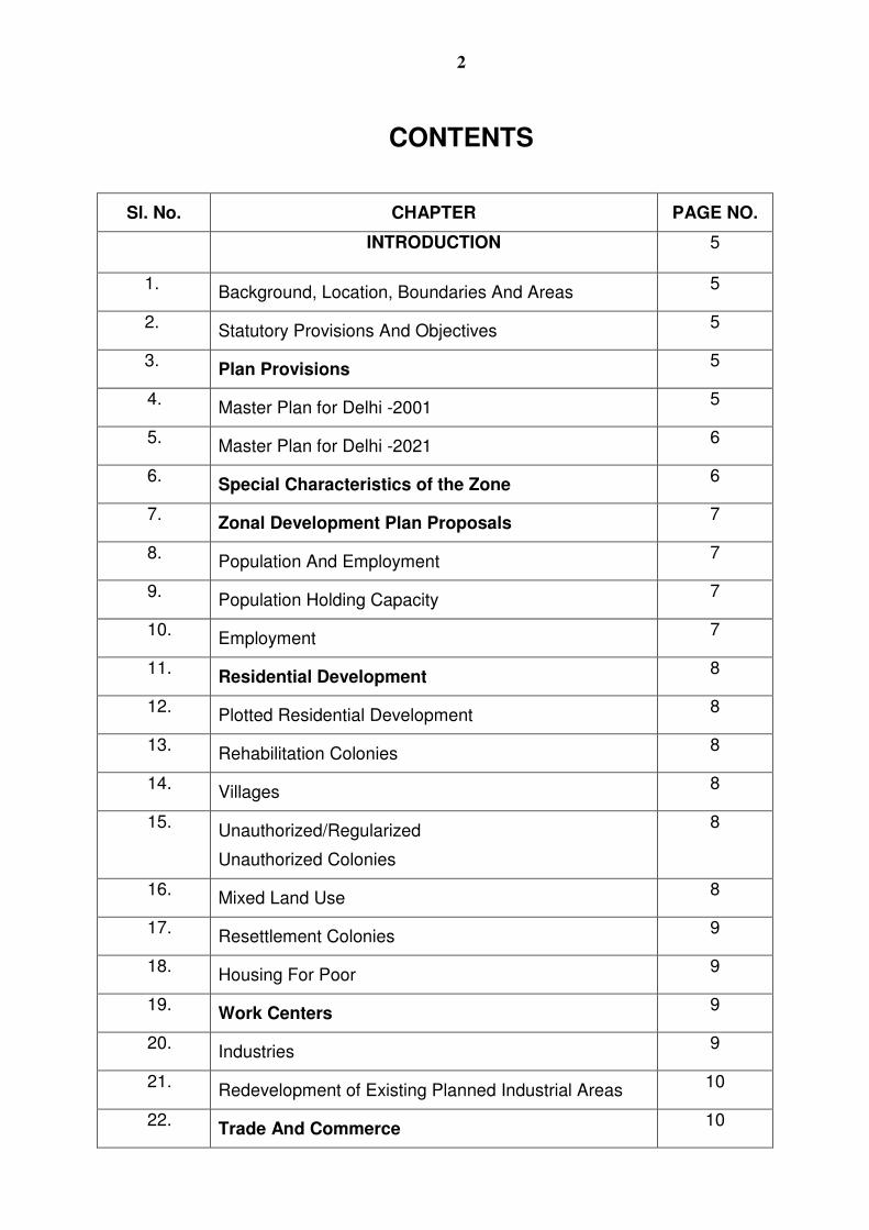
CONTENTS
Sl. No. CHAPTER PAGE NO.
INTRODUCTION
5
1. Background, Location, Boundaries And Areas 5
2. Statutory Provisions And Objectives 5
3. Plan Provisions
5
4. Master Plan for Delhi -2001 5
5. Master Plan for Delhi -2021 6
6. Special Characteristics of the Zone
6
7. Zonal Development Plan Proposals
7
8. Population And Employment 7
9. Population Holding Capacity 7
10. Employment 7
11. Residential Development
8
12. Plotted Residential Development 8
13. Rehabilitation Colonies 8
14. Villages 8
15. Unauthorized/Regularized
Unauthorized Colonies
8
16. Mixed Land Use 8
17. Resettlement Colonies 9
18. Housing For Poor 9
19. Work Centers
9
20. Industries 9
21. Redevelopment of Existing Planned Industrial Areas 10
22. Trade And Commerce
10
3
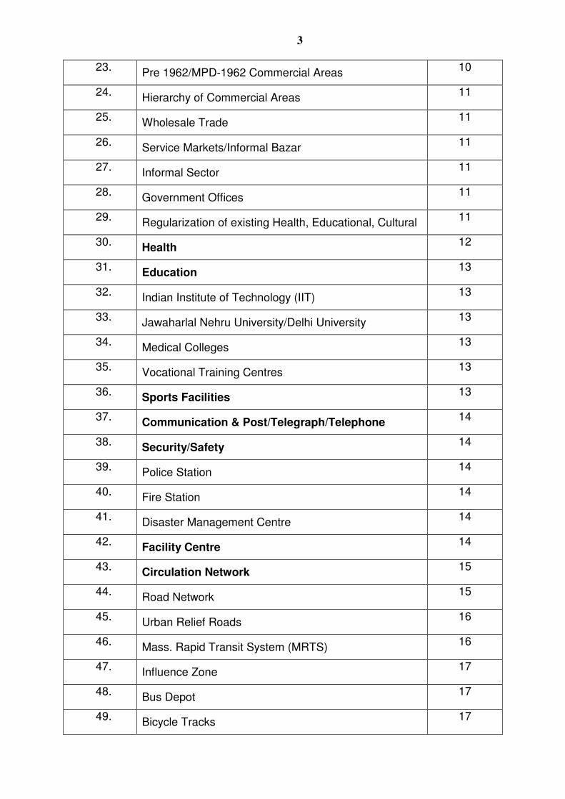
23. Pre 1962/MPD-1962 Commercial Areas 10
24. Hierarchy of Commercial Areas 11
25. Wholesale Trade 11
26. Service Markets/Informal Bazar 11
27. Informal Sector 11
28. Government Offices 11
29. Regularization of existing Health, Educational, Cultural 11
30. Health
12
31. Education
13
32. Indian Institute of Technology (IIT) 13
33. Jawaharlal Nehru University/Delhi University 13
34. Medical Colleges 13
35. Vocational Training Centres 13
36. Sports Facilities
13
37. Communication & Post/Telegraph/Telephone
14
38. Security/Safety
14
39. Police Station 14
40. Fire Station 14
41. Disaster Management Centre 14
42. Facility Centre
14
43. Circulation Network
15
44. Road Network 15
45. Urban Relief Roads 16
46. Mass. Rapid Transit System (MRTS) 16
47. Influence Zone 17
48. Bus Depot 17
49. Bicycle Tracks 17
4
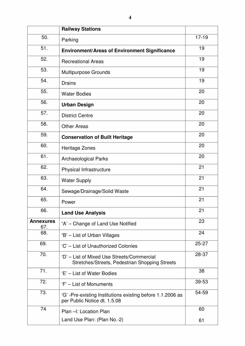
Railway Stations
50. Parking 17-19
51. Environment/Areas of Environment Significance
19
52. Recreational Areas 19
53. Multipurpose Grounds 19
54. Drains 19
55. Water Bodies 20
56. Urban Design
20
57. District Centre 20
58. Other Areas 20
59. Conservation of Built Heritage
20
60. Heritage Zones 20
61. Archaeological Parks 20
62. Physical Infrastructure 21
63. Water Supply 21
64. Sewage/Drainage/Solid Waste 21
65. Power 21
66. Land Use Analysis
21
Annexures 67.
‘A’ – Change of Land Use Notified 23
68. ‘B’ – List of Urban Villages 24
69. ‘C’ – List of Unauthorized Colonies 25-27
70. ‘D’ – List of Mixed Use Streets/Commercial Stretches/Streets, Pedestrian Shopping Streets
28-37
71. ‘E’ – List of Water Bodies 38
72. ‘F’ – List of Monuments 39-53
73. ‘G’ -Pre-existing Institutions existing before 1.1.2006 as per Public Notice dt. 1.5.08
54-59
74 Plan –I: Location Plan
Land Use Plan: (Plan No.-2)
60
61
5
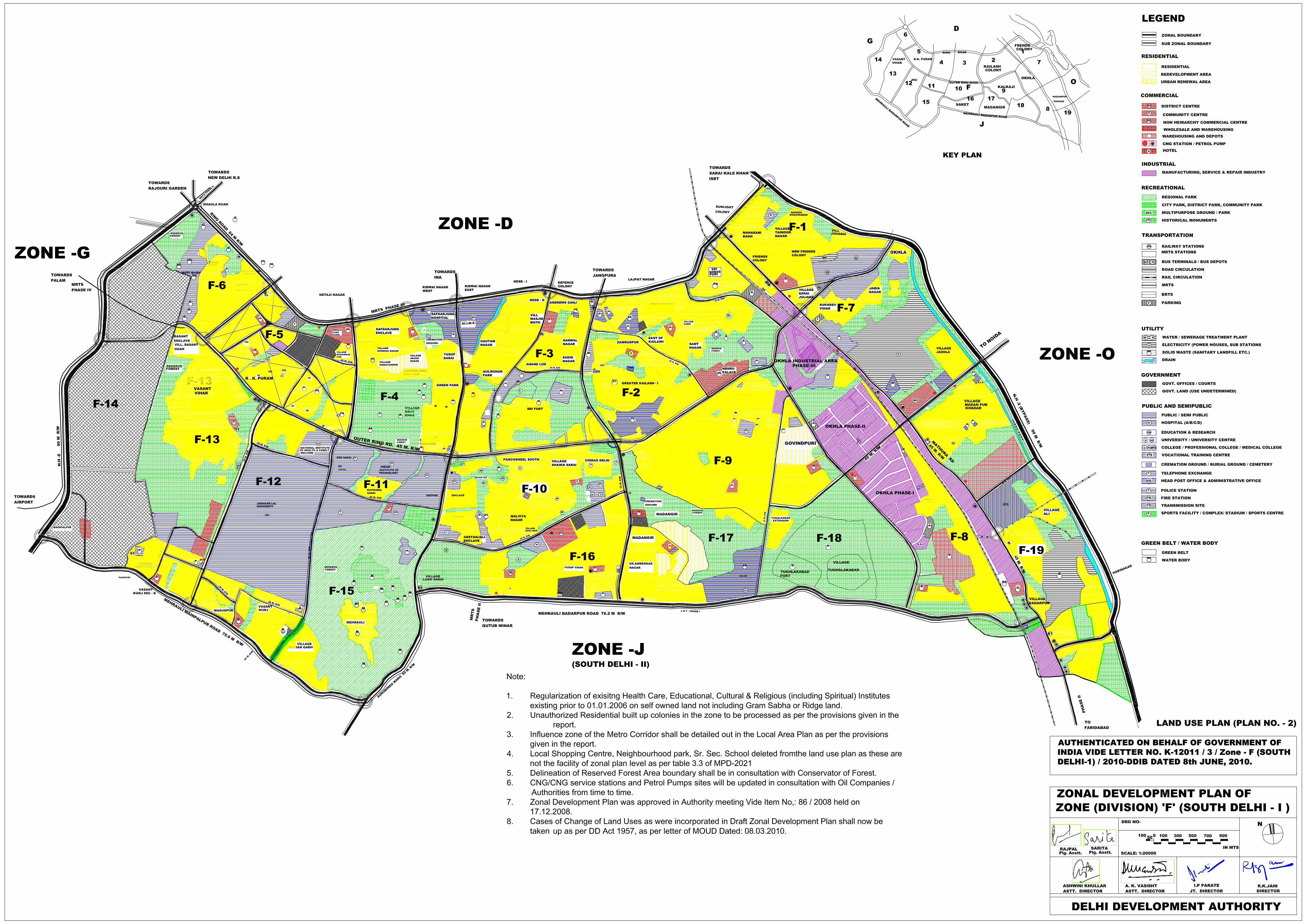
ZONAL DEVELOPMENT PLAN – ‘F’ (SOUTH DELHI –I) 1.0 INTRODUCTION: 1.1 BACKGROUND, LOCATION, BOUNDARIES AND AREAS: The National Capital Territory of Delhi has been divided in 15 - Planning Zones (Divisions) designated ‘A’ to ‘P’ (except (Zone ‘I’) as per Master Plan 2021, Zone ‘F’ covering an area of 11958-Ha. is situated towards the South of Ring Road from Dhaula Kuan to Maharani Bagh, in the East it is bounded by River Yamuna and NH-2 by-pass, in the West it is bounded by Delhi. Cantonment area, Indira Gandhi International Airport and by National Highway-8 and in the South it is bounded by Badarpur-Mehrauli-Mahipalpur Road (refer plan No.1)
This zone has been developing since pre-independence era through MPD-1962, MPD-2001 and now MPD-2021. As such, the zone has a hetrogenus characters, where the unplanned areas and planned areas developed under the norms of various plans co-exist.
This zone has some of the most prestigious institutions (like All India Institute of
Medical Sciences, Safdarjung Hospital, Holy Family Hospital), universities and educational institutes, such as South Campus of Delhi University, Indian Institute of Technology, Jawahar Lal Nehru University, Jamia Milia, etc. This zone also has a large number of significant historical monuments. 1.2 STATUTORY PROVISIONS AND OBJECTIVES: Further a Zonal Development Plan may contain a site plan and a land use plan with approximate location and extent of land uses, such as public and semi-public buildings, utilities, roads, housing, recreational, industry, commercial etc. It may also specify standards of population, density and various components of development of the zone. 1.3 PLAN PROVISIONS: 1.3.1 MASTER PLAN FOR DELHI – 2001:
As per MPD-2001, the Zonal Plan for Zone ‘F’ was prepared for a population of about 12,78,000 by the year 2001 and the total area of the Zone as 11,958-ha.
As per MPD-2001, the broad objectives are as under:
i) To preserve and enhance the green character of South Central Ridge (Mehrauli), forests and other green linkages.
ii) To make provisions for mixed use activities in residential areas. iii) To identify and conserve important historical monuments.
The Zonal Development Plan 2001 was approved by Govt. of India, Ministry of Urban Affairs and Employment vide letter no. K-13011/2/94-DDIB dt. 5.6.98.
1.3.2 MASTER PLAN FOR DELHI-2021 :
6
MPD-2021 has stipulated the population holding capacity of this zone to be about 19,75,000 and the total area of the Zone to be 11,958 ha.
MPD-2021 has stipulated a number of planning measures such as Local Area
Planning, Redevelopment of Villages, Unauthorized Colonies and Built up areas, Restructuring and up gradation of Residential Areas in the Influence Zone of MRTS and Major Transport Corridor, a network of Recreational and Sports facilities to be suitably incorporated while preparing the detailed Schemes.
Mapping of the Zone shall be done using remote sensing and GIS tools and shall
also be updated from time to time to have valuable data as regards ground situation and also to have inputs to detect and prevent unauthorized development and encroachment on public land and to facilitate the protection of greens. The help of Satellite Images and updated SOI Maps has been taken to find out the ground realities. 1.4. SPECIAL CHARACTERISTICS OF THE ZONE: Zone ‘F’ is identifiable with its low density and green character. This zone is mainly comprised of planned, well maintained posh residential localities. This also includes rehabilitation colonies and government housing areas. A significant feature of this zone is its urban heritage, where first four cities of Delhi namely, Lal Kot, Siri, Tuglakabad and Jahanpanah are located. There are number of developed parks which also includes city forests and the ridge area. Besides Lutyens’ Delhi, this zone has well planned residential areas. This Zone has been planned mostly as envisaged in Master Plan for Delhi – 1962. Some of the high income category residential localities are Vasant Vihar, West End, Anand Niketan, Punchsheel, Friends Colony, Maharani Bagh, Hauz Khas, South Extn., New Friends colony, Mayfair garden, Gulmohar Park, Geetanjali, East of Kailash, Safdarjung Development Scheme, etc. The residential locations of this zone can be divided in the following categories: a) Rehabilitation colonies. b) Govt. Housing Schemes. c) Co-operative House Building Societies. d) Privately developed colonies. e) Residential areas developed by the DDA including group hosing schemes. f) Slum & JJ housing Schemes. g) Unauthorized/regularized colonies. h) Urbanized villages.
There are three District Centers, namely, Nehru Place, Bhikaji Cama Place and Saket. This zone is unique in terms of large green area and open space. The South Central (Mehrauli Ridge) which is a conservation area falls in the hierarchy of Regional parks, Besides, large District parks, it has two city forests at Hauz Khas and Jahapanah. There are various sports complexes, like Siri Fort, Saket, Jasola and also Lawn Tennis Stadia. This zone has major public and semi-public facilities, both health and education. Some of these health and educational facilities are of national importance. The public and semi public facilities located in planned and developed area in this zone caters to the population of other zones. Three major social cultural institutional areas, viz Siri Fort, South of India Institute of Technology and Tughlakabad.
7
In the west of JNU, public & semi-public facilities, commercial areas, recreational areas and semi-developed areas are proposed to be developed. 2.0 ZONAL DEVELOPMENT PLAN :
A Zonal Development Plan means a plan for each Zone (Division) containing information regarding provisions of social infrastructure, parks and open spaces, circulation system etc. The Zonal Development Plan indicates the actual as well as proposed use zones designated in the 9 ‘land use’ categories stated in the Master Plan. According to which the area in the zone is to be finally developed. User indicated in the Zonal Development Plan will not give automatic right to the owners to use their property/land for the designated use. Based on the availability of infrastructure services by the respective departments, the urbanisable areas will be opened up for development in a phased manner to meet with the needs of urbanization envisaged in the Master Plan 2021. The hierarchy of Urban Development indicated in the Zonal Development plan is to be in conformity with table 3.3 of Master Plan – 2021.
2.1. POPULATION AND EMPLOYMENT :
i) Existing population year 2001 17,17,000 ii) Holding capacity as envisaged in MPD-2021 19,75,000 iii) Projected Population Year-2021 19,75,000
2.1.1 POPULATION HOLDING CAPACITY : Population holding capacity of Zone ‘F’ is to be enhanced through a redevelopment strategy and differential development norms as per MPD-2021. This shall be related with:
i) Residential development types and their potential for higher absorption. ii) Redensification of housing areas developed at lower densities and along
selected sections of the metro corridor. iii) Redevelopment areas should be identified by the concerned agencies and
special redevelopment schemes should be prepared for implementation with in a stipulated time frame work.
iv) Employment areas/ centres. v) Augmentation and rationalization of infrastructure – physical and social. vi) Increase in transportation network capacity.
2.1.2 EMPLOYMENT :
Based on various activities, this Zone has the following places to cater with the work force:
i) Okhla Industrial Area Ph-I, II & III. ii) Mohan Co-operative Industrial Area. iii) SISI Complex, Okhla near Modi Flour Mills. iv) District Courts. v) Delhi University – South Campus. vi) District Centers at Saket, Bhikaji Cama Place and Nehru Place. vii) Proposed Integrated Freight Complex at Madanpur Khadar. viii) Institutional area at South of IIT, Tuglakabad and Siri Fort. ix) Government Offices.
8
2.2 RESIDENTIAL DEVELOPMENT :
2.2.1 PLOTTED RESIDENTIAL DEVELOPMENT: Zone ‘F’ (South Delhi –I) is known for its posh residential colonies which afford an exclusive lifestyle. Most of these were developed by the co-operative House Building societies on the lands allotted by the Delhi Govt./Govt. of India, DDA except a few developed privately. Such colonies have recreational, shopping and other facilities. Keeping in view the significance of these residential pockets, further development should be regulated within the parameter of MPD-2021 to maintain and enhance their character. The largest govt. housing complex at R.K. Puram was developed at a comparatively low density. There are several other govt. housing complexes viz., Moti Bagh, Nankpura, Nauroji Nagar, Andrews Ganj, Sadiq Nagar, Pushp Vihar etc. Besides the govt. housing areas, there are other staff housing areas such as Air India, Indian Air Lines, Reserve Bank of India, MMTC, STC, Delhi Govt., MCD and DDA. These colonies were developed at a low density proposed for redensification of such pocket based on a comprehensive urban design scheme and providing required facilities as per the prevailing norms. Comprehensive schemes should be prepared by the concerned and using implementing agency for redevelopment of old housing areas. No piecemeal approach without an urban design scheme is to be adopted. 2.2.2 REHABILITATION COLONIES: There are several large rehabilitation colonies developed by the Ministry of Rehabilitation to provide accommodation for the displaced persons after the independence of the country. These include Lajpat Nagar, Kalkaji, Amar Colony, Malviya Nagar etc. These have become very congested, mainly due to non-residential activities in the residential premises. It is therefore, necessary that for certain pockets where there is a heavy congestion, urban renewal schemes be prepared and required infrastructure be provided by the local body. 2.2.3 VILLAGES: There are 36 villages in Zone ‘F’ (Refer Annexure ‘B’). The socio-economic changes in these villages have been substantial. The redevelopment plans should ensure that the permissibility of mixed use zoning at property or within the premise level is compatible to the predominant residential areas. Village Redevelopment Schemes must be prepared for villages for development and up gradation. The village abadi shall be treated as ‘Special Area’ where Special Area Regulation of MPD-2021 shall be applicable. 2.2.4 UNAUTHORIZED COLONIES: The process for regularisation of unauthorised colonies is being coordinated by the Govt. of NCTD. Regulations of unauthorised colonies is a continuing process and is subject to the Government guidelines approved from time to time. The tentative list of the unauthorised colonies falling in Zone ‘F’ has been annexed to this plan. As in the case of village abadis, the ‘land use’ of the finally approved unauthorised colonies located in any use zone, at any point of time, within the boundaries specified by the competent authority would be ‘Residential’ (Annexure ‘C’).
2.2.5 MIXED LAND USE: Ministry of Urban Development, Govt. of India and GNCTD vide notification dt. 7.9.2006, 14.9.2006, 15.9.2006 and 12.4.2007 have notified certain streets as mixed use streets, commercial stretches/streets and pedestrian shopping streets. List of the mixed use streets falling in Zone ‘F’ is at (Annexure ‘D).
9
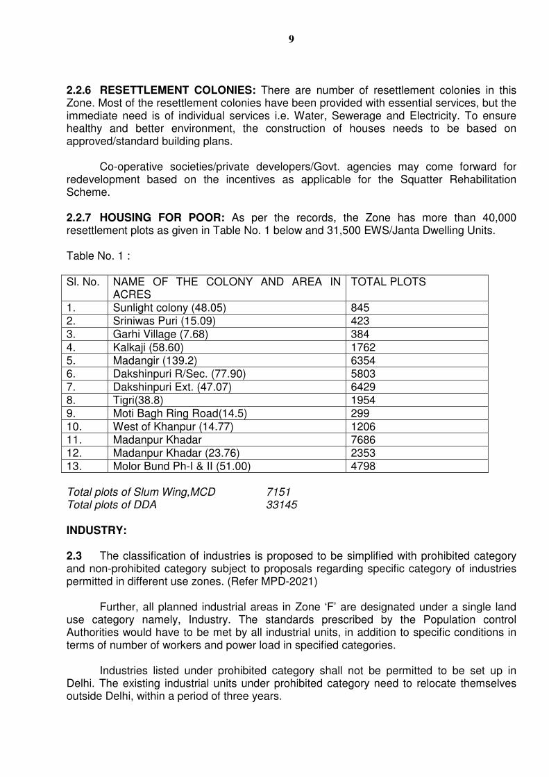
2.2.6 RESETTLEMENT COLONIES: There are number of resettlement colonies in this Zone. Most of the resettlement colonies have been provided with essential services, but the immediate need is of individual services i.e. Water, Sewerage and Electricity. To ensure healthy and better environment, the construction of houses needs to be based on approved/standard building plans.
Co-operative societies/private developers/Govt. agencies may come forward for redevelopment based on the incentives as applicable for the Squatter Rehabilitation Scheme. 2.2.7 HOUSING FOR POOR: As per the records, the Zone has more than 40,000 resettlement plots as given in Table No. 1 below and 31,500 EWS/Janta Dwelling Units. Table No. 1 : Sl. No. NAME OF THE COLONY AND AREA IN
ACRES TOTAL PLOTS
1. Sunlight colony (48.05) 845 2. Sriniwas Puri (15.09) 423 3. Garhi Village (7.68) 384 4. Kalkaji (58.60) 1762 5. Madangir (139.2) 6354 6. Dakshinpuri R/Sec. (77.90) 5803 7. Dakshinpuri Ext. (47.07) 6429 8. Tigri(38.8) 1954 9. Moti Bagh Ring Road(14.5) 299 10. West of Khanpur (14.77) 1206 11. Madanpur Khadar 7686 12. Madanpur Khadar (23.76) 2353 13. Molor Bund Ph-I & II (51.00) 4798 Total plots of Slum Wing,MCD 7151 Total plots of DDA 33145
INDUSTRY:
2.3 The classification of industries is proposed to be simplified with prohibited category and non-prohibited category subject to proposals regarding specific category of industries permitted in different use zones. (Refer MPD-2021) Further, all planned industrial areas in Zone ‘F’ are designated under a single land use category namely, Industry. The standards prescribed by the Population control Authorities would have to be met by all industrial units, in addition to specific conditions in terms of number of workers and power load in specified categories. Industries listed under prohibited category shall not be permitted to be set up in Delhi. The existing industrial units under prohibited category need to relocate themselves outside Delhi, within a period of three years.
10
2.3.1 REDEVELOPMENT OF EXISTING PLANNED INDUSTRIAL AREAS:
MPD-2021 has stated that guidelines for re-development of existing industrial areas shall be framed within 2 years by DDA in consultation with GNCTD and the local bodies.
The redevelopment schemes cover the following aspects: i) Modernization and upgradation of existing planned industrial areas; and ii) Redevelopment of area, which have become industrialised over the period of
the two Master Plans even though not designated as such. These industrialised areas were developed in the 70s and over the years, have deteriorated considerably in terms of physical infrastructure and in some cases deficiencies on this score have persisted in an overall sense. Besides, there have been changes in the nature of activities in some of the areas and there have also been demands for using part of the plots for activities, which could be classified as commercial. The following are the industrial areas in this zone:
i) Okhla Industrial Area Ph-I, II and III ii) Mohan Co-operative Industrial Area iii) SISI Complex, Okhla near Modi Flour Mill There is, therefore, a need for modernisation and up gradation of the existing industrial areas with due regard to environmental consideration. Since most of the industrial areas are located along the Mass Public Transport Corridors, there is also a need for optimizing the use around these areas through the process of redevelopment. This process of up gradation and redevelopment will need to be carried out in a planned manner, and in public-private partnership framework, in which the entrepreneurs contribute to the betterment and subsequent maintenance through suitable Operation and Maintenance arrangements.
2.4 TRADE AND COMMERCE: As per the MPD-2021 the five tier hierarchy of commercial areas is envisaged to accommodate required shopping, commercial office and other service activities like cinema, hotel and restaurant and various community services and facilities in an integrated manner. Service Market and Informal Bazar need to be integrated with district Centers wherever possible. Involvement of Developers, Owners associations in up gradation of infrastructure and built environment in Old District Centres is recommended.
In addition, some components of commercial use are also provided under mixed
use, non-hierarchical commercial Centres, and informal sector in the selected areas along the MRTS Corridor.
2.4.1 PRE 1962/MPD-1962: COMMERCIAL AREAS: Residential areas and streets/stretches earlier declared as commercial areas/streets or where commercial use was allowed in MPD-1962 shall continue such use at least to the extent as permissible in MPD-1962. Commercial activities existing from prior to 1962 in residential areas are also permitted subject to documentary proof thereof.
11
2.4.2. HIERARCHY OF COMMERCIAL AREAS: The five-tier system of Commercial Areas as envisaged in MPD-2021 will accommodate required shopping, commercial office and other service activities like cinema, hotel and restaurant and various community services and facilities in an integrated manner. There are three District Centers, viz. Nehru Place, Bhikaji Cama Place and Saket. Out of these two District Centers i.e. Nehru Place and Bhikaji Cama Place which are already developed and one at Saket is at developing stage. Two non-hierachy Commercial Centers were proposed in Zone – ‘F’. One at Khel Gaon Road in the vicinity of Siri Fort, the other at Okhla, adjoining the proposed passenger terminal. However, only one NC was proposed near the passenger terminal. The viability of the commercial center will depend upon the feasibility of the proposed passenger terminal. 2.4.3. WHOLESALE TRADE: An integrated freight Complex is proposed at Madanpur Khadar covering an area of 108 Ha. In addition, another 50 ha is proposed for a Truck Terminal adjoining this freight complex. This complex is envisaged as a composite scheme with godowns and transport facilities so that movement of goods by road and rail could work smoothly. 2.4.4 SERVICE MARKETS/INFORMAL BAZAR: Special attention is required for the low turnover and space extensive shops for fruits and vegetables, service and repair, junk and scrap materials (Kabari), building materials, automobile workshops etc. The grouping of such activities with planned retails markets leads to conversion of shops into high profit commercial activity. To avoid continuance of this situation, about 10% of the unutilized sites of Local Shopping Centre/Convenience Shopping Centre are proposed to be converted into service markets. These will be indicated in local area/layout plans. 2.4.5 INFORMAL SECTOR: The informal sector units locate themselves strategically near work centres, commercial areas, outside boundaries of schools, colleges, hospitals and transport nodes and near large housing clusters. A large number of units are mobile in nature. A very high percentage of this activity has been observed in Zone ‘F’. ‘Hawking and ‘No Hawking’ Zones are to be identified by the concerned local authority. 2.4.6 GOVERNMENT OFFICES: In this Zone, about 5% area is under Government Offices and locations of these offices are as given below:
i) Office Complex - R.K. Puram. ii) Office Complex- M.B. Road. iii) Office Complex opposite Pushp Vihar. iv) District Court Complex Saket.
2.5 REGULARISATION OF EXISTING HEALTH CARE, EDUCATIONAL, CULTURAL & RELIGIOUS (INCLUDING SPIRITUAL) INSTITUTES EXISTING PRIOR TO 01-01-2006 ON SELF OWNED LAND NOT INCLUDING GRAM SABHA OR RIDGE LAND.
2.5.1 In pursuance of the Public Notice issued in this regard, the Authority resolved incorporation & regularisation of the above uses/activities in the ‘Public & Semi Public’ land use category of the Master Plan. The applications of the existing institutions as listed in the Annexure-‘G’ shall be examined as per the Authority resolution and as per the directions of the Central Government issued from time to time. However, the regularisation of existing institutions located in the immediate vicinity of notified Ridge/Reserved Forest/Regional
12
Park shall be subject to finalization & demarcation of the boundaries of the aforesaid respective use zones/areas. 2.5.2 In case of cultural, health care and educational institutions, the structures of such institutes as existed as on 1/1/2006, but not beyond the prevailing relevant provisions of MPD-2021, shall be considered for regularization. However, in case of the existing religious (including spiritual) institutions and vis-à-vis the land presently owned by them, regularization shall be subject to the conditions that a) the built up area in these cases shall not exceed FAR of 15 with maximum 15% ground coverage; b)shall be confined to the buildings, which are directly related to the use activities – religious (including Spiritual); c) the structures as existed on 1/1/2006 shall only be considered; and d) the remaining area shall be kept as “green area” with no construction to be permitted in future.
The regularization of all the above institutions shall be confined to those listed in the Annexure –III of this Plan or those cases recommended by DDA to the Government on or before 8th march, 2010, & shall be undertaken only after ensuring that the change of land use u/s 11A of DD Act, 1957 is notified in conformity with the provisions of MPD-2021 as and where required. This is further subject to the condition that such individual cases shall not be considered for regularization, if the site in question is located:
a) On public/Government land; or on land acquired by DDA. b) On encroached land; or on illegal occupied land; c) In notified or reserved forest area; d) In area of right of way infrastructure such as of existing/proposed railway
lines/master plan roads, major trunk water supply and sewerage lines etc. e) Or if it violates the provisions of the Ancient Monuments and Archeological
Remains Act, 1958, amended from time to time; f) Or in cases where there is a Court Order restraining change of land use or
for eviction/vacation of premises. 2.5.3 Further, regularization orders of these categories of institutions shall not be considered as approved, unless the requisite payment of penalty/levy/additional FAR charges etc. are deposited by the applicant institutes; all the conditions prescribed by the Government are fulfilled and formal ‘Regularization Orders’ are issued by the DDA. None of the above institutes shall, however, be entitled to put the land to any other land use at any time, and doing so shall invite takeover of land by the DDA for alternative uses, on payment of reasonable compensation. 2.6 SOCIAL INFRASTRUCTURE
2.6.1 HEALTH: MPD-2021 states that the existing bed density per thousand population in Delhi works out to only 2.2. The World Health Organization (WHO) has recommended a norm of 5 beds per thousand population.
MPD-2021 has categorized Hospitals into the following Categories: Category A (501 beds and above) for every 5 lakh population.
Category B (201 beds to 500 beds) for every 2.5 lakh population.
Category C (101 beds to 200 beds) for every 1 lakh population.
Category D (upto 100 beds) for every 1 lakh population.
13
Other health facilities, which include maternity home, nursing home, family welfare
centre, polyclinic, pediatrics centre, diagnostic centre etc. shall be provided as per the norms given in MPD-2021. 2.6.1.1 List of Hospitals in Zone ‘F’ is as under:
i) Holy Family Hospital ii) Escorts Hospital iii) A.I.I.M.S. iv) Safdarjung Hospital v) Apollo Hospital vi) Venu Eye Institute Hospital vii) Pushpawati Singhania Hospital viii) Lala Ram Swarup T.B. Hospital ix) G.M. Modi Hospital x) Max Muller Hospital xi) Majeedia Hamdard Hospital
Rebuilding, up gradation and modernization of existing old hospitals is proposed by enhancement of FAR for various levels of health facilities.
2.6.2 EDUCATION:
2.6.2.1 INDIAN INSTITUTE OF TECHNOLOGY (IIT): It is one of the premier Institutes located in Zone ‘F’ near Village Katwaria Sarai.
2.6.2.2 JAWAHARLAL NEHRU UNIVERSITY/DELHI UNIVERSITY: Jawaharlal Nehru University and Delhi University is a city level facility. Delhi University has number of Colleges in this area within their own complex, namely, Atma Ram, Shri Venketshwer College, LSR, Moti Lal Nehru College, Gargi College, Ram Lal Anand College, Aurbindo College etc.. Jawaharlal Nehru University is located in the South of outer Ring Road along Nelson Mandela Road. 2.6.2.3 MEDICAL COLLEGES: There are two Medical Colleges i.e. All India Institute of Medical Sciences (AIIMS) and Safdarjung Hospital which are strategically located and have many specialised health facilities to serve the city population as well as that of the region and in many respects, the country as a whole. 2.6.2.4 VOCATIONAL TRAINING CENTRES: As per MPD-2021 norms one ITI (Vocational Training Institute) is required for every 5 lakh population. This Zone has one ITI (for Women) near Siri Fort Complex and two Polytechnics, namely, G.B. Panth and Meera Bhai Womens’ Polytechnic and one Vocational college located near Venu Hospital. 2.6.3 SPORTS FACILITIES: Sizeable sports facilities have been developed in the city by various agencies like the Sports Authority of India (SAI), DDA, GNCTD, etc. However, sports activities, so far, been dealt with as a part of Recreational use. It is also felt that many of the facilities, which have been developed, could actually be seen as recreation and/or club type of facilities. Zone ‘F’ has large network of excellent sports facilities, like, Siri Fort Sports Complex, Saket Sports Complex, Vasant Kunj Sports Complex, Sports facilities within Deer Park and Jasola Sports Complex.
14
2.6.4 COMMUNICATION & POST/TELEGRAPH/TELEPHONE FACILITY: As per MPD-2021 the site for Telephone Exchange and other means of communications shall not be reserved in layout plan due to liberalization and technological advancement.
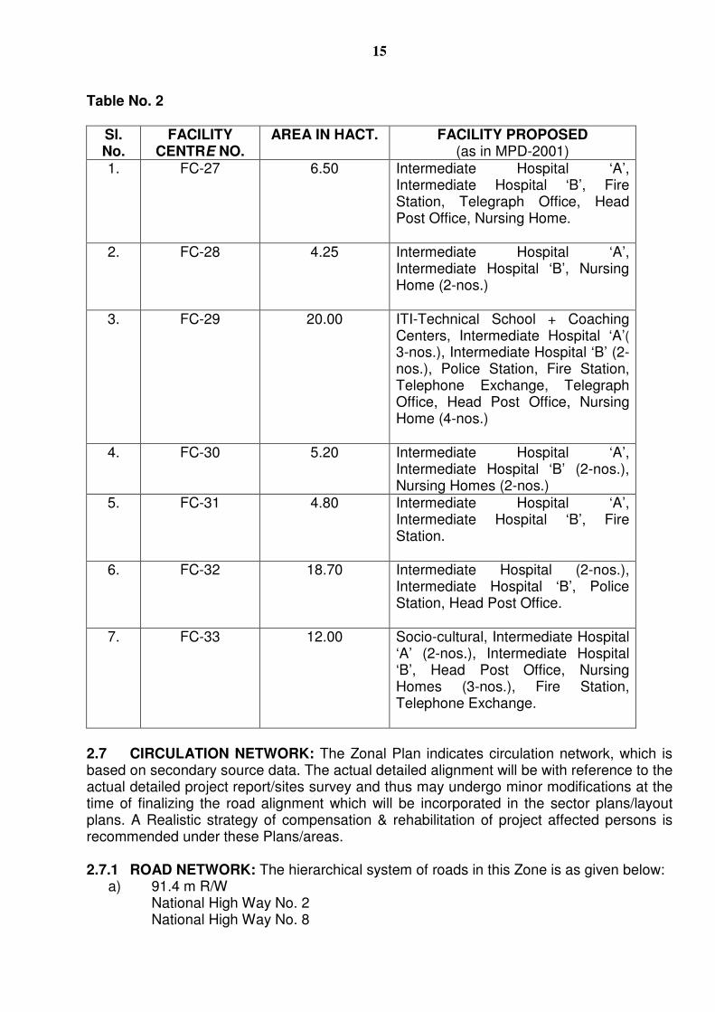
Two Transmission Center sites are marked in this zone near Siri Fort and near Grater Kailash-I. 2.6.5 SECURITY/SAFETY: The main agency looking after security aspect in the city is Delhi Police. 2.6.5.1 POLICE STATION: Fourteen Police Stations at different locations are existing in this area. 2.6.5.2 FIRE STATION: As per norms, three Fire Stations for every 5 lakh population are to be provided in 5-7 Km. radius, therefore 12 Fire Stations are required in this Zone. 2.6.6 DISASTER MANAGEMENT CENTER: As per MPD-2021, it is proposed to have a Disaster Management centre in each Administrative Zone. One Disaster Management Centre can be proposed on Mathura Road in IFC Madanpur Khadar with suitable parking, temporary shelter, parade ground etc. 2.6.7 FACILITY CENTRES: The Schemes for Facility Centre were prepared as per the norms given in the Master Plan for Delhi-2001. As the requirements are changed over the years, the land unutilised for the facilities earlier proposed can be used for other facilities as per requirement. The Facility Centers in this Zone ‘F’ as given in Table No. 2 below shall be used as part of Public & Semi Public use.
15
Table No. 2
Sl. No.
FACILITY CENTRE NO.
AREA IN HACT. FACILITY PROPOSED (as in MPD-2001)
1. FC-27 6.50 Intermediate Hospital ‘A’, Intermediate Hospital ‘B’, Fire Station, Telegraph Office, Head Post Office, Nursing Home.
2. FC-28 4.25 Intermediate Hospital ‘A’, Intermediate Hospital ‘B’, Nursing Home (2-nos.)
3. FC-29 20.00 ITI-Technical School + Coaching Centers, Intermediate Hospital ‘A’( 3-nos.), Intermediate Hospital ‘B’ (2-nos.), Police Station, Fire Station, Telephone Exchange, Telegraph Office, Head Post Office, Nursing Home (4-nos.)
4. FC-30 5.20 Intermediate Hospital ‘A’, Intermediate Hospital ‘B’ (2-nos.), Nursing Homes (2-nos.)
5. FC-31 4.80 Intermediate Hospital ‘A’, Intermediate Hospital ‘B’, Fire Station.
6. FC-32 18.70 Intermediate Hospital (2-nos.), Intermediate Hospital ‘B’, Police Station, Head Post Office.
7. FC-33 12.00 Socio-cultural, Intermediate Hospital ‘A’ (2-nos.), Intermediate Hospital ‘B’, Head Post Office, Nursing Homes (3-nos.), Fire Station, Telephone Exchange.
2.7 CIRCULATION NETWORK: The Zonal Plan indicates circulation network, which is based on secondary source data. The actual detailed alignment will be with reference to the actual detailed project report/sites survey and thus may undergo minor modifications at the time of finalizing the road alignment which will be incorporated in the sector plans/layout plans. A Realistic strategy of compensation & rehabilitation of project affected persons is recommended under these Plans/areas. 2.7.1 ROAD NETWORK: The hierarchical system of roads in this Zone is as given below:
a) 91.4 m R/W National High Way No. 2 National High Way No. 8
16
b) 60 to 64 m R/W Ring Road, Aurbindo Marg, Mehruali Road, Mehrauli-Badarpur Road.
c) 45 m R/W Outer Ring Road, Mathura Road, Abdul Gamel Nasir Marg, Panchasheel Marg, Chirag Delhi Road, Josep Tito Marg, Lal Bahadur Shastri Marg, Lala Lajpat Rai Path, Africa Avenue, Nelson Mandela Marg, Rao Tula Ram Marg etc.
d) 30-38 m R/W Vivekanand Marg, Khel Gaon Road No. 11 & 12 opposite IIT and in front of JNU, Road No. 13 & 14 near Govind Puri, Kalkaji and Ambedkar Nagar, Road No. 4 near East of Kailash.
The Grade Separators existing and proposed have been indicated in the land use plan. All road owning agencies shall get Road Development Plan prepared for 30 m. and above R/W roads shown in MPD-2021 along with interchange details of junctions/intersections showing location of bus-stops, metro stations and the pedestrian linkages falling in the alignment for smooth change over from one mode to the other mode. 2.7.2 URBAN RELIEF ROADS: MPD-2021 has proposed number of Urban Relief Roads all over Delhi. The following Urban Relief Roads have been identified in this zone:
i) Road between Nehru Place and Hotel Park Royal to be extended up to Lotus Temple and towards East of Kailash, if feasible.
ii) Badarpur Border entry point. iii) Sarita Vihar (Junction of Mathura Road and Road No. 13-A) to Okhla Industrial
Areas (road between Ph-I and Ph-II to be connected by ROB or RUB). Additional stretches of missing links could be identified from time to time by the
concerned agencies. Their project maybe implemented after carrying out detailed studies. 2.7.3 MASS RAPID TRANSIT SYSTEM (MRTS): An integrated multi-mode transport system within the overall structure of the city is envisaged in MPD-2021. it is envisaged that the future transport system shall consist of a mix of rail and road based systems which may include Metro Rails, Ring Rail, dedicated rail corridors for daily commuters. Bus Rapid Transit System (BRTS) other mass transit modes as technologies become available and Intermediate Passenger Transport (IPT) and private modes on selected corridors to be identified as per the needs from time to time. All roads should be made pedestrian, disabled and bicycle friendly as far as possible. The Metro Rail System is the most important, component, of a Mass Rapid System (MRTS) in the City. The Metro Rail network for the entire city has been identified in various phases, which comprises of a network of underground, elevated and surface corridors. There are two Corridors passing through this zone, which are:
i) Central Secretariat – Qutub Minar ii) Central Secretariat – Badarpur
Further extension of MRTS, if any, maybe taken up as and when required. This MRTS network would bring sizable urban area within walking distance from the proposed stations.
17
Besides, there are proposal of Light Rail Transit (LRT), Bus Rapid Transport (BRT) and High Capacity Bus Service (HCBS) corridor, in order to provide further convenience to common masses. The LRT route stretches from Badarpur to Vasant Kunj through Mehrauli-Mahipalpur Road. The BRT corridor passes through the outer ring road as well as on Moolchand-Chirag Delhi Road. The HCBS route starts from ‘T’ junction of Mehrauli-Badarpur Road and Dr. Ambedkar Road via Lal Bahadur Shastri Marg, Josip Broz Tito Marg to Delhi Gate. 2.7.4 INFLUENCE ZONE:As per Master Plan 2021 Para 3.3.2 Influence Zone along MRTS Corridor and the Sub Zones for redevelopment and renewal should be identified on the basis of physical features such as metro, roads, drains, high tension lines and control zones of monuments/heritage areas etc. This identification is to be done in consultation with GNCTD.
In Zonal Development Plan the number of colony roads, local drains, high tension
wires, heritage areas etc. are not indicated. Therefore, boundary of Influence Zone has not been indicated in the Zonal Development Plan. It will be shown only in the local area plans, which are more sites specific. 2.7.5 BUS DEPOT: In MPD-2021, it is envisaged to have One Bus Depot for a population of 5 lakhs. Accordingly, the required number of Bus Depots is four for a population of 19,75,000 persons. At present, there are seven operating under DTC. Two Depots are not under operation due to ground realities in R.K. Puram and Vasant Vihar.
2.7.6 BICYCLE TRACKS: Segregated Cycle tracks shall be proposed on feeder roads to Metro Stations only where “Park and Ride” facilities are available. These shall not be permitted on Arterial Roads. Existing Cycle tracks are on the following Roads:
a) One of these cycle tracks-link Chirag Delhi, Defence Colony along the Nallah and leads to Inderaprastha Estate Office Complex, along Mathura Road.
b) The other cycle track coming from Trans Yamuna areas, along ITO bridge,
connects Connaught Place and moves further down along Panchkuian Road.
c) Another cycle track would connect Talkatora Stadium and Mathura Road via Kushak Nallah.
2.7.7 RAILWAY STATIONS: Presently two Railway Stations/Railway Yards are existing in
this zone. These are Okhla and Tuglakabad. 2.7.8 PARKING: With the phenomenal increase in personalized motor vehicles, one of the
major problems being faced today is an acute shortage of parking space.
Parking has become a matter of serious public concern and requires a carefully considered policy and planned measures to alleviate the problem to the maximum feasible extent in existing areas and for adequate provisioning with reference to future developments. In this background, the following measures are proposed:
18
a) PARK AND RIDE: Park and Ride lots are available on MRTS station. Apart
from providing Park and Ride facilities with reference to integration between the Road and Metro Rail/Rail Transport System, such facilities shall be provided to reduce the problem of parking on main arterial roads in the context of identified work and activity centres which may not be directly connected by the MRTS and to encourage use of pubic transport.
b) PUBLIC PARKING: The major efforts will have to come through the creation of public facilities in designated commercial/work centres and other areas and corridors where significant commercial activity has developed by way of mixed use. In the context of the latter, it would also need to be linked to pedestrianisation within the identified areas.
c) PARKING FACILITIES IN DTC DEPOTS: The use of DTC terminals and depots for development of public parking along with parking of DTC buses, private buses and chartered buses should be explored and specific projects developed.
d) UNDERGROUND PARKING: Based on the site feasibility, parking facilities can be created under the open spaces without disturbing the green areas on the surface and surrounding environment. The approvals from the concerned agencies are mandatory before taking up such works.
e) PARKING IN RESIDENTIAL AREAS: Most of the parking is, in fact, being done on the road, which significantly reduces the carriage way width. The problem has been exacerbated by the traffic congestion generated by schools in residential areas. Some measures required to alleviate the problem, to some extent, will be as under:
i) All the encroachments on residential streets in the form of kitchen
gardens/road side private greens, large projections/ ramps etc. need to be removed.
ii) Road cross sections may be redesigned wherever possible to accommodate planned car parking along the residential streets and also creating more surface movement space.
iii) Other options, in selected areas, such as creation of underground parking below parks and open spaces will also have to be considered.
iv) Resident Welfare Associations will have to be called upon to participate in this process by raising contributions from the residents on the basis of objective criteria such as number of cars owned, etc. Problem of congestion arising on account of the traffic generated by schools have to be specifically addressed, and the main responsibility for putting up the required additional facilities has to be borne by the schools themselves. Policy guidelines will have to be evolved for this purpose.
f) MULTILEVEL PARKING: As per MPD-2021, Multilevel parking is proposed in
different part of the city looking into the traffic. This facility should preferably be developed in the designated parking and proposed commercial areas. In this zone Multilevel parking is proposed to be developed in the Community Centre, District Centres wherever possible, apart from other sites.
19
g) IDLE TRUCK PARKING: Idle tuck parking has been proposed in the land earmarked for IFC at Madanpur Khadar.
2.8 ENVIRONMENT/AREAS OF ENVIRONMENT SIGNIFICANCE: The South Central Ridge (Mehrauli) covers an area of 626 ha. It is an area of urban heritage, which has land marks and traces of the historical cities of Delhi. Besides this Tughlakabad is another important green area in the zone. The other major green areas, viz., around important monuments, planned green areas and other natural green areas need to be conserved. Conservation and restoration of the places of rich urban heritage and high tourist value should be taken up on priority. There is an urgent need to intensify aforestation of the ridge area. Certain areas, which have been notified as a Reserved Forest under the Forest Act shall be retained as such, where no construction, temporary or permanent is permitted. 2.8.1 RECREATIONAL AREAS: Zone ‘F’ has a much larger green cover than any of the other Zone and could well be called a ‘Green Zone’. The major green spaces are complemented and supplemented by a system of neighborhood open spaces, parks and playgrounds in the residential area. This would provide linkages for development of a continuous system of green areas. This has been indicated in the Zonal Plan, which should be detailed out at the stage of preparation of detailed schemes.
It is also proposed to develop the unutilized green spaces along the road and
adjoining to Institutional/Industrial/Commercial etc. by inviting participation of RWA’s/NGO’s etc. In addition to above, one Bio-diversity park is under development by the DDA at Vasant Vihar. 2.8.2 MULTIPURPOSE GROUNDS: A network of the multi-purpose grounds, which are basically of parks and open spaces are categorized in MPD-2021 at three levels viz City Multipurpose Ground, District Multipurpose Ground and Community Multipurpose Ground. These multi purpose grounds are at the community level shall be upto 2-ha., at the District level of 4 ha. and the city (Zone) level shall be upto 8-ha. Already approved parks on 60’-O’’ road for holding marriages by the local body/MCD are designated as multipurpose grounds. It has been proposed to utilize the following green areas for Multi purpose grounds:
i) Mahipal Pur ii) Lado Sarai iii) Behind Safdarjung Hospital iv) Jasola v) The parks already approved by Local Body/MCD/DDA/Govt. for holding
marriages are designated as Multi purpose Grounds. 2.8.3 DRAINS: There are seven drains passing through this Zone:
i) Barapullah Drain ii) Maharani Bagh Drain iii) Kalkaji Drain iv) Okhla Drain v) Tughlakabad Drain vi) Sarita Vihar Drain vii) Tekhand Drain
20
The drains shall be developed as green corridors and environmental Study shall be done before any part of the drain is covered.
There is proposal of IDFC on ‘South Delhi Green Ways’ along Barapulla drain to
connect the large open space in a linear ways for a green corridor near Quila Rai Pithora via Satpula lake, Siri Fort to Hamayun Tomb. 2.8.4 WATER BODIES: Water bodies, having a minimum size of surface area of 1ha. shall be preserved by the concerned authorities. Further efforts shall be made at the local area level to retain the smaller water bodies. This list of water bodies having an area more then one Ha. (Annexure-‘E’)
2.9 URBAN DESIGN:
2.9.1 DISTRICT CENTER: A District Centre should have all the components to create a pleasant environment with easy accessibility from the major transport modes and surrounding residential areas through pedestrian approach or by sub ways etc. Planned District Centres can be best utilized for creating public spaces. 2.9.2 OTHER AREAS: Other areas of Urban Design importance are as follows:
i) Historical monuments and gardens, Qutub Minar Complex, Vijay Mandal, Quila Rai Pithora, Tuglakabad Fort, Khirki villages, etc. and gardens like Mehrauli area, Hauz Khas, Jahapanah, Astha Kunj etc.
ii) Areas along entry routes and other important routes in Delhi – Badarpur
Border (NH-2), NH-8.
iii) Road and Rail, MRTS corridors, entries, and terminals – Tuglakabad Railway Station, Central Secretariat – Qutub Minar, Central Secretariat – Badarpur.
2.10 CONSERVATION OF BUILT HERITAGE: According to the Archeological Survey of India there are number of monuments in Delhi which have been notified as protected. It is envisaged that the extent of areas of heritage and declared protected monument under the ancient Monument and Archeological Sites and Remains Act, 1958, be reserved for conservation for which conservation schemes may be prepared by the concerned organization/local authority. Use of Heritage Building shall be put as per recommendation of the Heritage Conservation Committee. 2.10.1 HERITAGE ZONES: The areas have been identified as Heritage Zones.
i) Specific heritage complex within Mehrauli area. ii) Specific heritage complex within Vijay Mandal-Begumpur-Sarai, Shahji-Lal
Gumbad. iii) Specific heritage complex within Chirag Delhi.
2.10.2 ARCHAELOGICAL PARKS: The following areas have been designated as
Archaeological parks: i) Mehrauli Archaeological Park ii) Tuglakabad Archaeological Park.
The list of centrally protected monument, ASI and GNCTD in Zone ‘F’ (Annexure ‘F’)
21
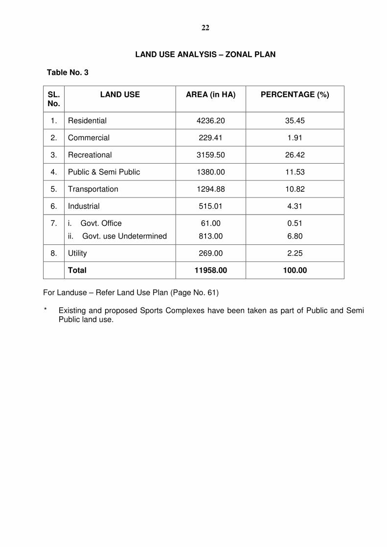
2.11 PHYSICAL INFRASTRUCTURE: The requirement of water, Sewerage, Power and Solid Waste Disposal for this zone shall be worked out in consultation with the concerned department and Engineering Department of DDA. 2.11.1 WATER SUPPLY: As per MPD-2021, it is proposed to augment the capacity of these Water Treatment plants to 919 mgd by 2021. The water supply would have to be augmented specially in view of preventing acute shortage and also the trend of population growth. In this zone there is one water treatment plant at Okhla and DJB has proposed construction of 20 mgd. water treatment plant at Okhla, to meet the short fall upto 2011. 2.11.2 SEWARAGE/DRAINAGE/SOLID WATER: The zone is almost fully served by underground sewerage. However, it is suggested to augment the sewerage network in the old areas identified for urban renewal. The zone has several major storm water drains, which flush out the storm water into the river. The zone has large sanitary landfill sites; on Maa Anand Mai Marg (Okhla Industrial Area Ph-I). However, for disposal of garbage, modern technology and methods which are environmentally more safe need to be adopted. 2.11.3 POWER: The existing power generation station in this zone is Badarpur Thermal Power Station. As per the Master Plan norms there is a need for 4 nos. of 220 KV ESS in this zone. It is suggested that no overhead cables be provided in this zone due to the urban design aspects. The power supply needs to be planned by the concerned department, keeping in view the increasing trends of power consumption and population growth. 2.12 LAND USE PLAN: The land analysis as per Zonal Plan is given in the Table No. 3 below. This includes the modification which have already been processed & notified under Section 11A of Delhi Development Act. These are listed as Annexure ‘A’
22
LAND USE ANALYSIS – ZONAL PLAN
Table No. 3
SL. No.
LAND USE AREA (in HA) PERCENTAGE (%)
1. Residential 4236.20 35.45
2. Commercial 229.41 1.91
3. Recreational 3159.50 26.42
4. Public & Semi Public 1380.00 11.53
5. Transportation 1294.88 10.82
6. Industrial 515.01 4.31
7. i. Govt. Office
ii. Govt. use Undetermined
61.00
813.00
0.51
6.80
8. Utility 269.00 2.25
Total 11958.00 100.00
For Landuse – Refer Land Use Plan (Page No. 61)
* Existing and proposed Sports Complexes have been taken as part of Public and Semi Public land use.
23
Annexure ‘A’ (Refer 2.12)
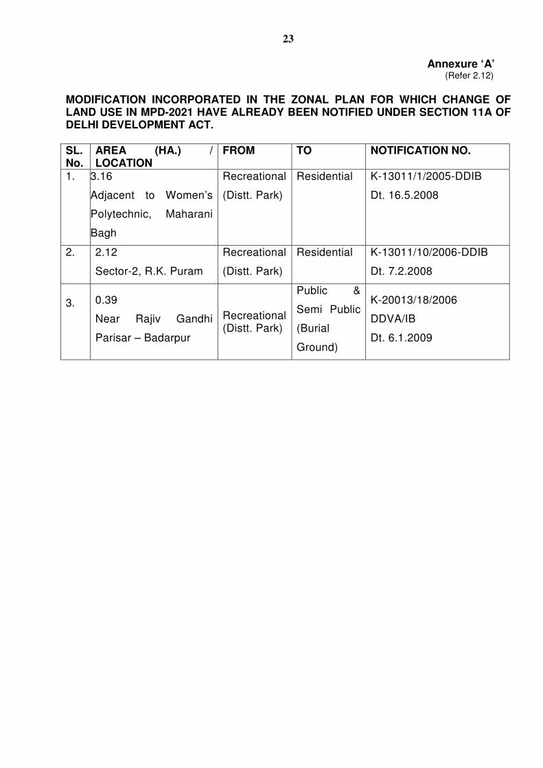
MODIFICATION INCORPORATED IN THE ZONAL PLAN FOR WHICH CHANGE OF LAND USE IN MPD-2021 HAVE ALREADY BEEN NOTIFIED UNDER SECTION 11A OF DELHI DEVELOPMENT ACT. SL. No.
AREA (HA.) / LOCATION
FROM TO NOTIFICATION NO.
1. 3.16
Adjacent to Women’s
Polytechnic, Maharani
Bagh
Recreational
(Distt. Park)
Residential K-13011/1/2005-DDIB
Dt. 16.5.2008
2. 2.12
Sector-2, R.K. Puram
Recreational
(Distt. Park)
Residential K-13011/10/2006-DDIB
Dt. 7.2.2008
3. 0.39
Near Rajiv Gandhi
Parisar – Badarpur
Recreational (Distt. Park)
Public &
Semi Public
(Burial
Ground)
K-20013/18/2006
DDVA/IB
Dt. 6.1.2009
24
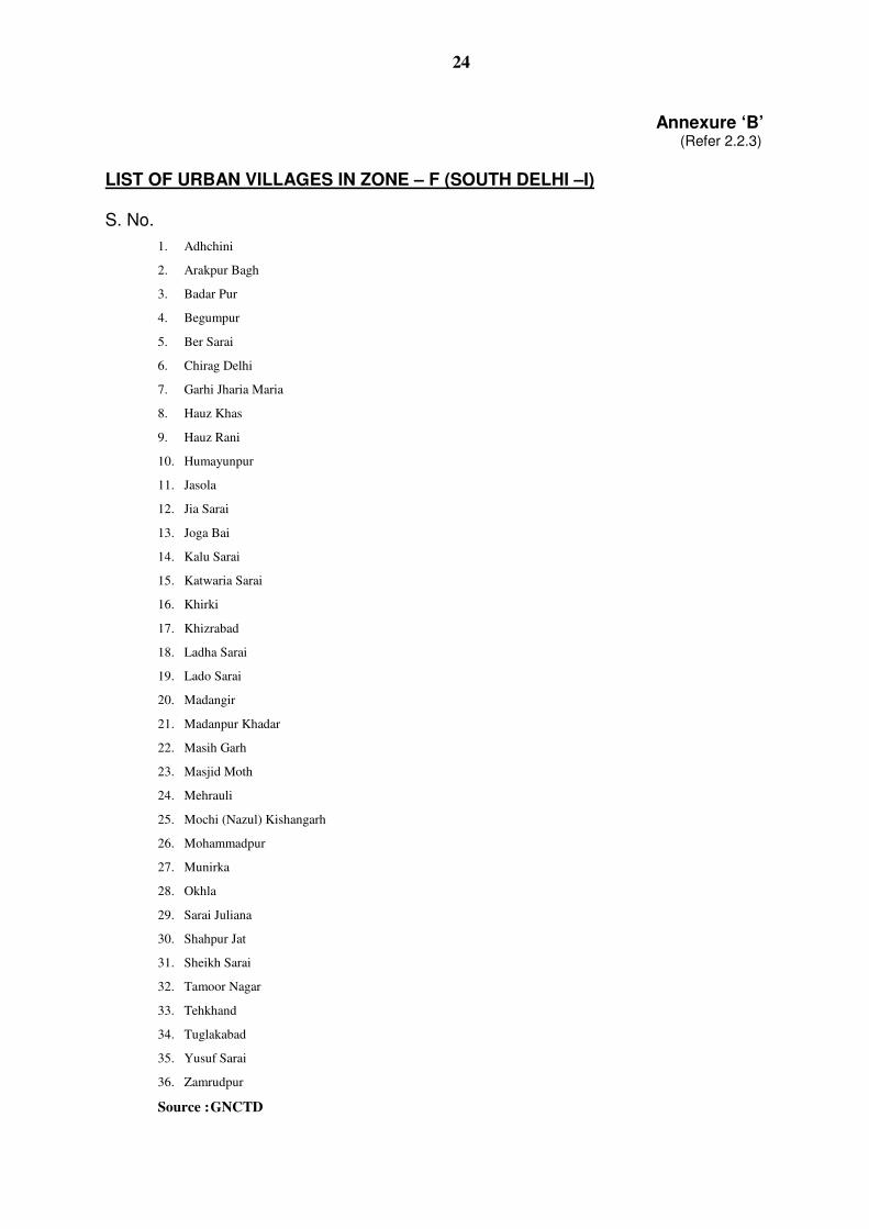
Annexure ‘B’ (Refer 2.2.3)
LIST OF URBAN VILLAGES IN ZONE – F (SOUTH DELHI –I) S. No.
1. Adhchini
2. Arakpur Bagh
3. Badar Pur
4. Begumpur
5. Ber Sarai
6. Chirag Delhi
7. Garhi Jharia Maria
8. Hauz Khas
9. Hauz Rani
10. Humayunpur
11. Jasola
12. Jia Sarai
13. Joga Bai
14. Kalu Sarai
15. Katwaria Sarai
16. Khirki
17. Khizrabad
18. Ladha Sarai
19. Lado Sarai
20. Madangir
21. Madanpur Khadar
22. Masih Garh
23. Masjid Moth
24. Mehrauli
25. Mochi (Nazul) Kishangarh
26. Mohammadpur
27. Munirka
28. Okhla
29. Sarai Juliana
30. Shahpur Jat
31. Sheikh Sarai
32. Tamoor Nagar
33. Tehkhand
34. Tuglakabad
35. Yusuf Sarai
36. Zamrudpur
Source : GNCTD
25
Annexure – C
(Refer 2.2.4)
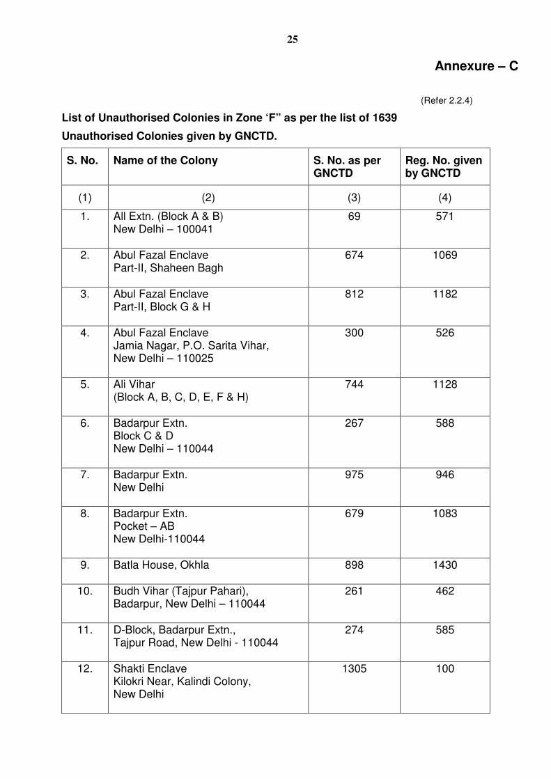
List of Unauthorised Colonies in Zone ‘F” as per the list of 1639
Unauthorised Colonies given by GNCTD.
S. No. Name of the Colony S. No. as per GNCTD
Reg. No. given by GNCTD
(1) (2) (3) (4)
1. All Extn. (Block A & B) New Delhi – 100041
69 571
2. Abul Fazal Enclave Part-II, Shaheen Bagh
674 1069
3. Abul Fazal Enclave Part-II, Block G & H
812 1182
4. Abul Fazal Enclave Jamia Nagar, P.O. Sarita Vihar, New Delhi – 110025
300 526
5. Ali Vihar (Block A, B, C, D, E, F & H)
744 1128
6. Badarpur Extn. Block C & D New Delhi – 110044
267 588
7. Badarpur Extn. New Delhi
975 946
8. Badarpur Extn. Pocket – AB New Delhi-110044
679 1083
9. Batla House, Okhla
898 1430
10. Budh Vihar (Tajpur Pahari), Badarpur, New Delhi – 110044
261 462
11. D-Block, Badarpur Extn., Tajpur Road, New Delhi - 110044
274 585
12. Shakti Enclave Kilokri Near, Kalindi Colony, New Delhi
1305 100
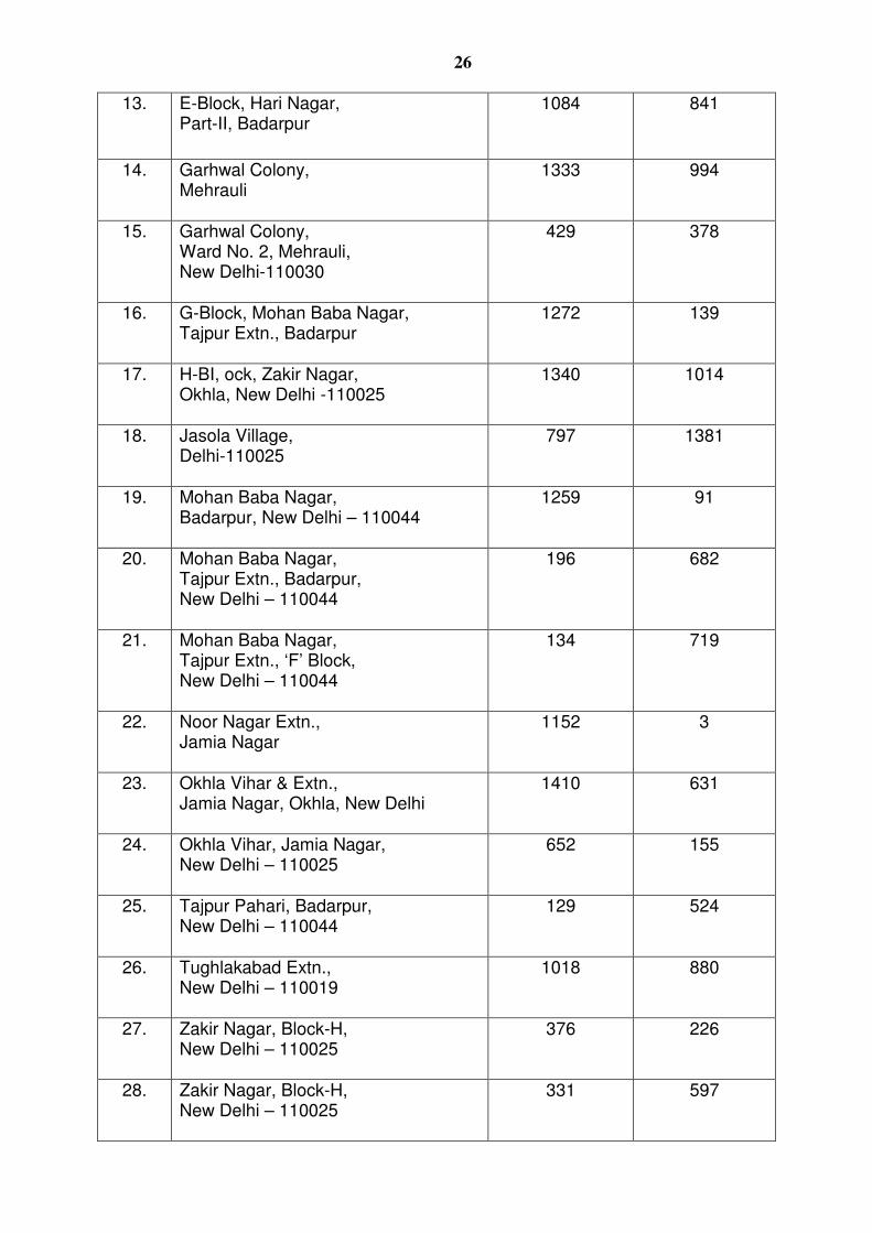
26
13. E-Block, Hari Nagar, Part-II, Badarpur
1084 841
14. Garhwal Colony, Mehrauli
1333 994
15. Garhwal Colony, Ward No. 2, Mehrauli, New Delhi-110030
429 378
16. G-Block, Mohan Baba Nagar, Tajpur Extn., Badarpur
1272 139
17. H-BI, ock, Zakir Nagar, Okhla, New Delhi -110025
1340 1014
18. Jasola Village, Delhi-110025
797 1381
19. Mohan Baba Nagar, Badarpur, New Delhi – 110044
1259 91
20. Mohan Baba Nagar, Tajpur Extn., Badarpur, New Delhi – 110044
196 682
21. Mohan Baba Nagar, Tajpur Extn., ‘F’ Block, New Delhi – 110044
134 719
22. Noor Nagar Extn., Jamia Nagar
1152 3
23. Okhla Vihar & Extn., Jamia Nagar, Okhla, New Delhi
1410 631
24. Okhla Vihar, Jamia Nagar, New Delhi – 110025
652 155
25. Tajpur Pahari, Badarpur, New Delhi – 110044
129 524
26. Tughlakabad Extn., New Delhi – 110019
1018 880
27. Zakir Nagar, Block-H, New Delhi – 110025
376 226
28. Zakir Nagar, Block-H, New Delhi – 110025
331 597
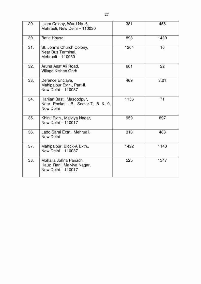
27
29. Islam Colony, Ward No. 6, Mehrauli, New Delhi – 110030
381 456
30. Batla House
898 1430
31. St. John’s Church Colony, Near Bus Terminal, Mehruali – 110030
1204 10
32. Aruna Asaf Ali Road, Village Kishan Garh
601 22
33. Defence Enclave, Mahipalpur Extn., Part-II, New Delhi – 110037
469 3.21
34. Harijan Basti, Masoodpur, Near Pocket –B, Sector-7, 8 & 9, New Delhi
1156 71
35. Khirki Extn., Malviya Nagar, New Delhi – 110017
959 897
36. Lado Sarai Extn., Mehruali, New Delhi
318 483
37. Mahipalpur, Block-A Extn., New Delhi – 110037
1422 1140
38. Mohalla Johna Panach, Hauz Rani, Malviya Nagar, New Delhi – 110017
525 1347
28
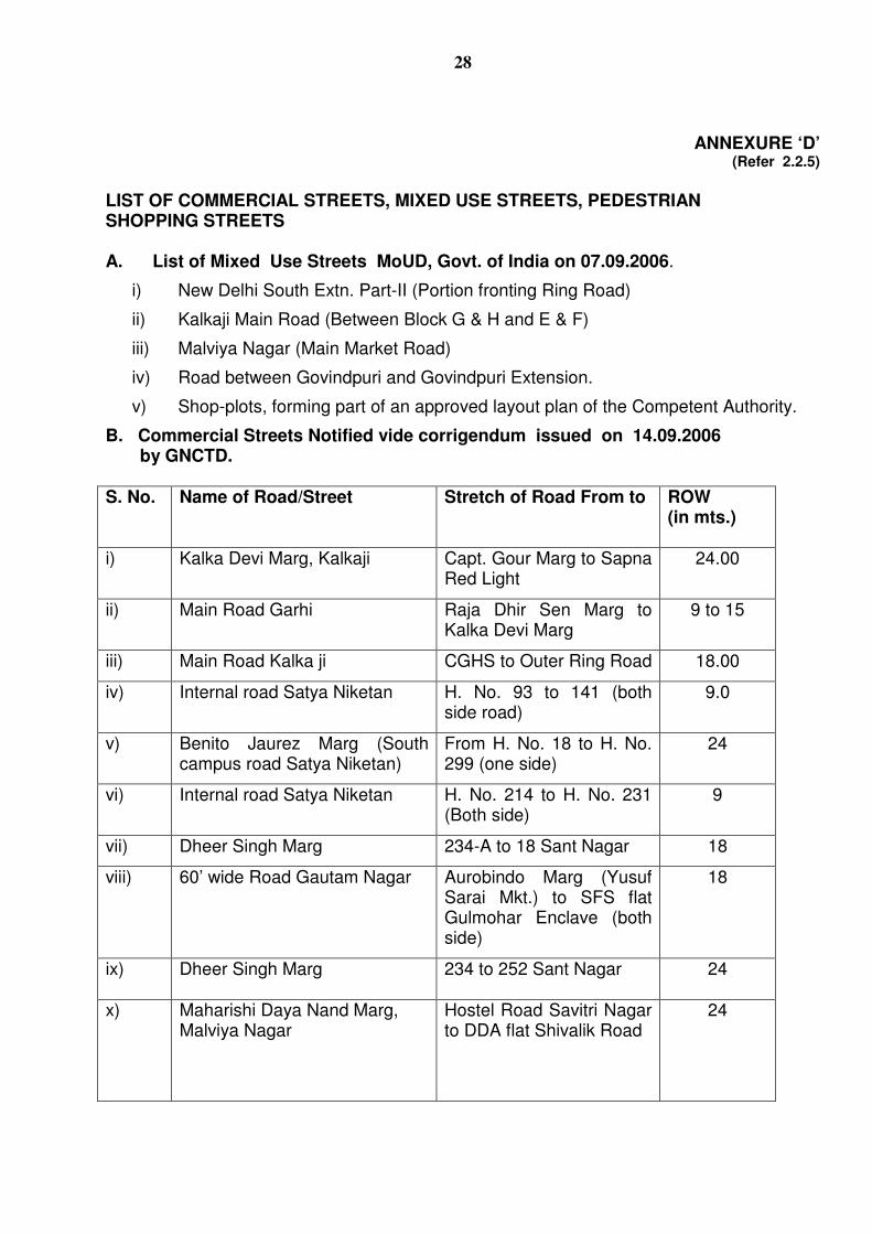
ANNEXURE ‘D’ (Refer 2.2.5)
LIST OF COMMERCIAL STREETS, MIXED USE STREETS, PEDESTRIAN SHOPPING STREETS A. List of Mixed Use Streets MoUD, Govt. of India on 07.09.2006.
i) New Delhi South Extn. Part-II (Portion fronting Ring Road)
ii) Kalkaji Main Road (Between Block G & H and E & F)
iii) Malviya Nagar (Main Market Road)
iv) Road between Govindpuri and Govindpuri Extension.
v) Shop-plots, forming part of an approved layout plan of the Competent Authority.
B. Commercial Streets Notified vide corrigendum issued on 14.09.2006 by GNCTD. S. No. Name of Road/Street Stretch of Road From to ROW
(in mts.)
i) Kalka Devi Marg, Kalkaji Capt. Gour Marg to Sapna Red Light
24.00
ii) Main Road Garhi Raja Dhir Sen Marg to Kalka Devi Marg
9 to 15
iii) Main Road Kalka ji CGHS to Outer Ring Road
18.00
iv) Internal road Satya Niketan H. No. 93 to 141 (both side road)
9.0
v) Benito Jaurez Marg (South campus road Satya Niketan)
From H. No. 18 to H. No. 299 (one side)
24
vi) Internal road Satya Niketan H. No. 214 to H. No. 231 (Both side)
9
vii) Dheer Singh Marg 234-A to 18 Sant Nagar
18
viii) 60’ wide Road Gautam Nagar Aurobindo Marg (Yusuf Sarai Mkt.) to SFS flat Gulmohar Enclave (both side)
18
ix) Dheer Singh Marg 234 to 252 Sant Nagar
24
x) Maharishi Daya Nand Marg, Malviya Nagar
Hostel Road Savitri Nagar to DDA flat Shivalik Road
24
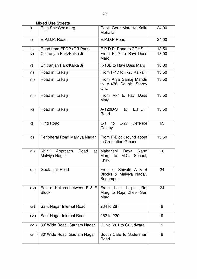
29
Mixed Use Streets i) Raja Shir Sen marg Capt. Gour Marg to Kallu
Mohalla
24.00
ii) E.P.D.P. Road E.P.D.P Road
24.00
iii) Road from EPDP (CR Park) E.P.D.P. Road to CGHS 13.50 iv) Chitranjan Park/Kalka Ji From K-17 to Ravi Dass
Marg
18.00
v) Chitranjan Park/Kalka Ji K-13B to Ravi Dass Marg
18.00
vi) Road in Kalka ji From F-17 to F-26 Kalka ji
13.50
vii) Road in Kalka ji From Arya Samaj Mandir to A-476 Double Storey Qrs.
13.50
viii) Road in Kalka ji From M-7 to Ravi Dass Marg
13.50
ix) Road in Kalka ji A-120D/S to E.P.D.P Road
13.50
x) Ring Road E-1 to E-27 Defence Colony
63
xi) Peripheral Road Malviya Nagar From F-Block round about to Cremation Ground
13.50
xii) Khirki Approach Road at Malviya Nagar
Maharishi Daya Nand Marg to M.C. School, Khirki
18
xiii) Geetanjali Road Front of Shivalik A & B Blocks & Malviya Nagar, Begumpur
24
xiv) East of Kailash between E & F Block
From Lala Lajpat Raj Marg to Raja Dheer Sen Marg
24
xv) Sant Nagar Internal Road 234 to 287
9
xvi) Sant Nagar Internal Road 252 to 220
9
xvii) 30’ Wide Road, Gautam Nagar H. No. 201 to Gurudwara
9
xviii) 30’ Wide Road, Gautam Nagar South Cafe to Sudershan Road
9
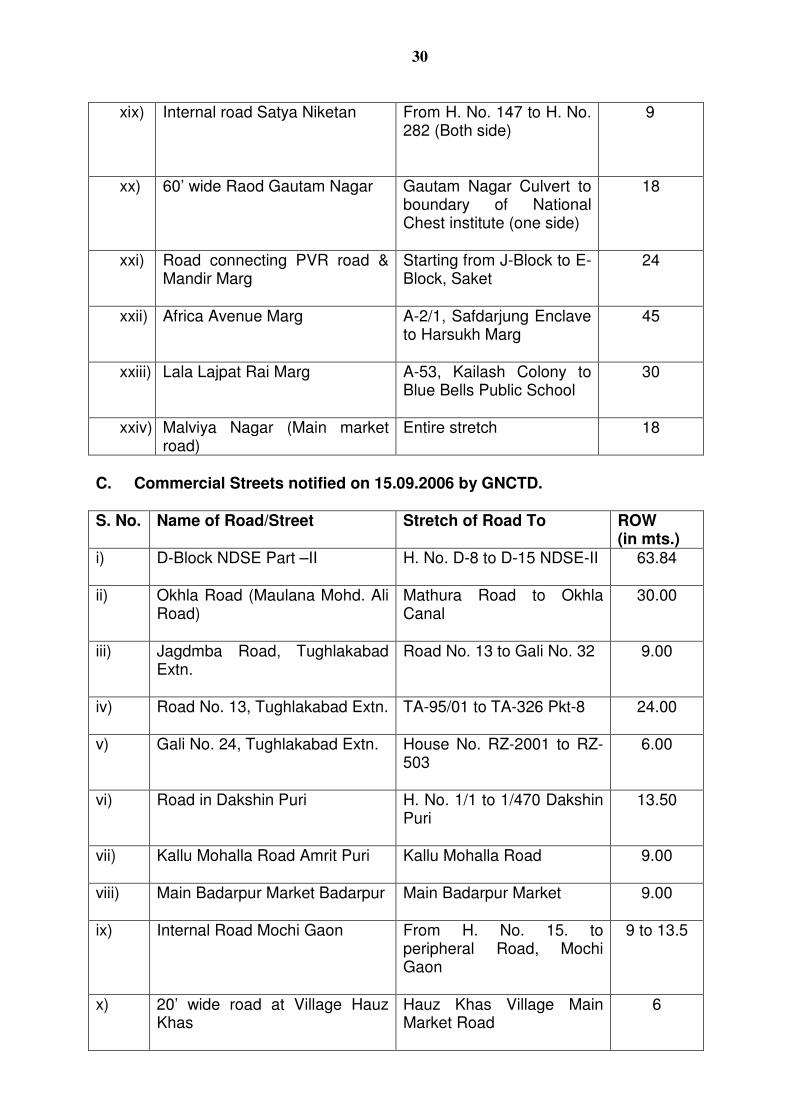
30
xix) Internal road Satya Niketan From H. No. 147 to H. No. 282 (Both side)
9
xx) 60’ wide Raod Gautam Nagar Gautam Nagar Culvert to boundary of National Chest institute (one side)
18
xxi) Road connecting PVR road & Mandir Marg
Starting from J-Block to E-Block, Saket
24
xxii) Africa Avenue Marg A-2/1, Safdarjung Enclave to Harsukh Marg
45
xxiii) Lala Lajpat Rai Marg A-53, Kailash Colony to Blue Bells Public School
30
xxiv) Malviya Nagar (Main market road)
Entire stretch 18
C. Commercial Streets notified on 15.09.2006 by GNCTD. S. No. Name of Road/Street Stretch of Road To ROW
(in mts.) i) D-Block NDSE Part –II
H. No. D-8 to D-15 NDSE-II 63.84
ii) Okhla Road (Maulana Mohd. Ali Road)
Mathura Road to Okhla Canal
30.00
iii) Jagdmba Road, Tughlakabad Extn.
Road No. 13 to Gali No. 32 9.00
iv) Road No. 13, Tughlakabad Extn.
TA-95/01 to TA-326 Pkt-8 24.00
v) Gali No. 24, Tughlakabad Extn. House No. RZ-2001 to RZ-503
6.00
vi) Road in Dakshin Puri H. No. 1/1 to 1/470 Dakshin Puri
13.50
vii) Kallu Mohalla Road Amrit Puri
Kallu Mohalla Road 9.00
viii) Main Badarpur Market Badarpur
Main Badarpur Market 9.00
ix) Internal Road Mochi Gaon From H. No. 15. to peripheral Road, Mochi Gaon
9 to 13.5
x) 20’ wide road at Village Hauz Khas
Hauz Khas Village Main Market Road
6
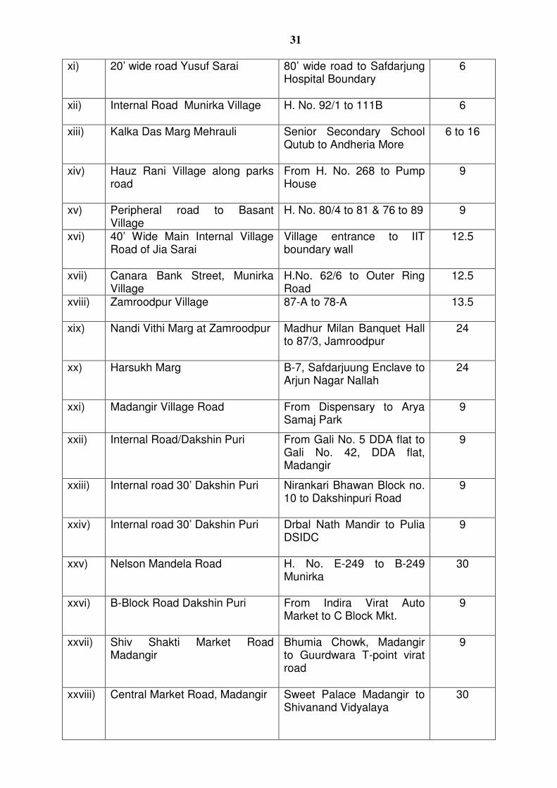
31
xi) 20’ wide road Yusuf Sarai 80’ wide road to Safdarjung Hospital Boundary
6
xii) Internal Road Munirka Village H. No. 92/1 to 111B
6
xiii) Kalka Das Marg Mehrauli Senior Secondary School Qutub to Andheria More
6 to 16
xiv) Hauz Rani Village along parks road
From H. No. 268 to Pump House
9
xv) Peripheral road to Basant Village
H. No. 80/4 to 81 & 76 to 89
9
xvi) 40’ Wide Main Internal Village Road of Jia Sarai
Village entrance to IIT boundary wall
12.5
xvii) Canara Bank Street, Munirka Village
H.No. 62/6 to Outer Ring Road
12.5
xviii) Zamroodpur Village 87-A to 78-A
13.5
xix) Nandi Vithi Marg at Zamroodpur Madhur Milan Banquet Hall to 87/3, Jamroodpur
24
xx) Harsukh Marg B-7, Safdarjuung Enclave to Arjun Nagar Nallah
24
xxi) Madangir Village Road From Dispensary to Arya Samaj Park
9
xxii) Internal Road/Dakshin Puri From Gali No. 5 DDA flat to Gali No. 42, DDA flat, Madangir
9
xxiii) Internal road 30’ Dakshin Puri Nirankari Bhawan Block no. 10 to Dakshinpuri Road
9
xxiv) Internal road 30’ Dakshin Puri Drbal Nath Mandir to Pulia DSIDC
9
xxv) Nelson Mandela Road H. No. E-249 to B-249 Munirka
30
xxvi) B-Block Road Dakshin Puri From Indira Virat Auto Market to C Block Mkt.
9
xxvii) Shiv Shakti Market Road Madangir
Bhumia Chowk, Madangir to Guurdwara T-point virat road
9
xxviii) Central Market Road, Madangir Sweet Palace Madangir to Shivanand Vidyalaya
30
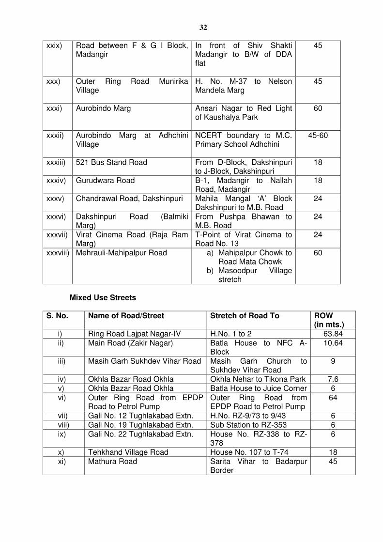
32
xxix) Road between F & G I Block, Madangir
In front of Shiv Shakti Madangir to B/W of DDA flat
45
xxx) Outer Ring Road Munirika Village
H. No. M-37 to Nelson Mandela Marg
45
xxxi) Aurobindo Marg Ansari Nagar to Red Light of Kaushalya Park
60
xxxii) Aurobindo Marg at Adhchini Village
NCERT boundary to M.C. Primary School Adhchini
45-60
xxxiii) 521 Bus Stand Road
From D-Block, Dakshinpuri to J-Block, Dakshinpuri
18
xxxiv) Gurudwara Road B-1, Madangir to Nallah Road, Madangir
18
xxxv) Chandrawal Road, Dakshinpuri Mahila Mangal ‘A’ Block Dakshinpuri to M.B. Road
24
xxxvi) Dakshinpuri Road (Balmiki Marg)
From Pushpa Bhawan to M.B. Road
24
xxxvii) Virat Cinema Road (Raja Ram Marg)
T-Point of Virat Cinema to Road No. 13
24
xxxviii) Mehrauli-Mahipalpur Road a) Mahipalpur Chowk to Road Mata Chowk
b) Masoodpur Village stretch
60
Mixed Use Streets S. No. Name of Road/Street Stretch of Road To ROW
(in mts.) i) Ring Road Lajpat Nagar-IV H.No. 1 to 2 63.84 ii) Main Road (Zakir Nagar) Batla House to NFC A-
Block 10.64
iii) Masih Garh Sukhdev Vihar Road Masih Garh Church to Sukhdev Vihar Road
9
iv) Okhla Bazar Road Okhla Okhla Nehar to Tikona Park 7.6 v) Okhla Bazar Road Okhla Batla House to Juice Corner 6 vi) Outer Ring Road from EPDP
Road to Petrol Pump Outer Ring Road from EPDP Road to Petrol Pump
64
vii) Gali No. 12 Tughlakabad Extn. H.No. RZ-9/73 to 9/43 6 viii) Gali No. 19 Tughlakabad Extn. Sub Station to RZ-353 6 ix) Gali No. 22 Tughlakabad Extn. House No. RZ-338 to RZ-
378 6
x) Tehkhand Village Road House No. 107 to T-74 18 xi) Mathura Road Sarita Vihar to Badarpur
Border 45
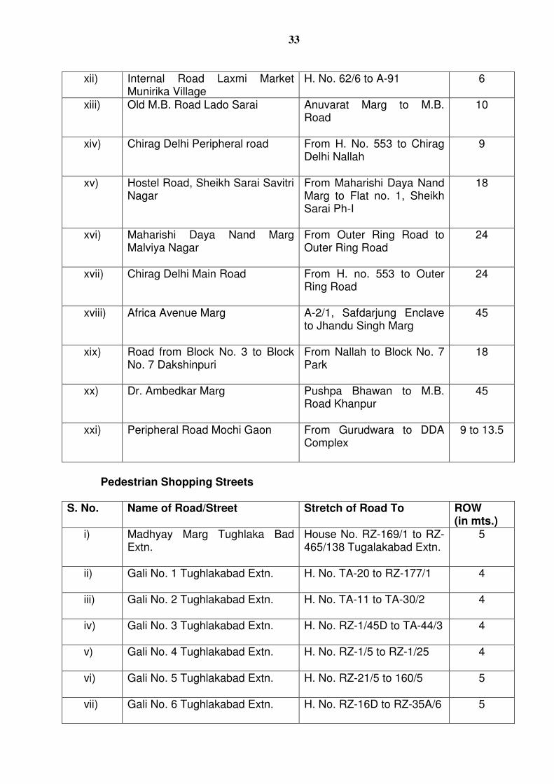
33
xii) Internal Road Laxmi Market Munirika Village
H. No. 62/6 to A-91 6
xiii) Old M.B. Road Lado Sarai Anuvarat Marg to M.B. Road
10
xiv) Chirag Delhi Peripheral road From H. No. 553 to Chirag Delhi Nallah
9
xv) Hostel Road, Sheikh Sarai Savitri Nagar
From Maharishi Daya Nand Marg to Flat no. 1, Sheikh Sarai Ph-I
18
xvi) Maharishi Daya Nand Marg Malviya Nagar
From Outer Ring Road to Outer Ring Road
24
xvii) Chirag Delhi Main Road From H. no. 553 to Outer Ring Road
24
xviii) Africa Avenue Marg A-2/1, Safdarjung Enclave to Jhandu Singh Marg
45
xix) Road from Block No. 3 to Block No. 7 Dakshinpuri
From Nallah to Block No. 7 Park
18
xx) Dr. Ambedkar Marg Pushpa Bhawan to M.B. Road Khanpur
45
xxi) Peripheral Road Mochi Gaon From Gurudwara to DDA Complex
9 to 13.5
Pedestrian Shopping Streets
S. No. Name of Road/Street Stretch of Road To ROW (in mts.)
i) Madhyay Marg Tughlaka Bad Extn.
House No. RZ-169/1 to RZ-465/138 Tugalakabad Extn.
5
ii) Gali No. 1 Tughlakabad Extn. H. No. TA-20 to RZ-177/1
4
iii) Gali No. 2 Tughlakabad Extn. H. No. TA-11 to TA-30/2
4
iv) Gali No. 3 Tughlakabad Extn. H. No. RZ-1/45D to TA-44/3
4
v) Gali No. 4 Tughlakabad Extn. H. No. RZ-1/5 to RZ-1/25
4
vi) Gali No. 5 Tughlakabad Extn. H. No. RZ-21/5 to 160/5
5
vii) Gali No. 6 Tughlakabad Extn. H. No. RZ-16D to RZ-35A/6
5
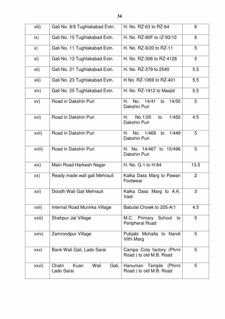
34
viii) Gali No. 8/9 Tughlakabad Extn. H. No. RZ-63 to RZ-64
6
ix) Gali No. 10 Tughlakabad Extn. H. No. RZ-80F to rZ-93/10
6
x) Gali No. 11 Tughlakabad Extn. H. No. RZ-9/20 to RZ-11
5
xi) Gali No. 13 Tughlakabad Extn. H. No. RZ-306 to RZ-4128
5
xii) Gali No. 21 Tughlakabad Extn. H. No. RZ-379 to 2540
5.5
xiii) Gali No. 23 Tughlakabad Extn. H No. RZ-1069 to RZ-401 5.5
xiv) Gali No. 25 Tughlakabad Extn. H. No. RZ-1912 to Masjid
5.5
xv) Road in Dakshin Puri H. No. 14/41 to 14/50 Dakshin Puri
5
xvi) Road in Dakshin Puri H. No.1/20 to 1/450 Dakshin Puri
4.5
xvii) Road in Dakshin Puri H. No. 1/469 to 1/449 Dakshin Puri
5
xviii) Road in Dakshin Puri H. No. 14/467 to 15/496 Dakshin Puri
5
xix) Main Road Harkesh Nagar H. No. G-1 to H-84
13.5
xx) Ready made wali gali Mehrauli Kalka Dass Marg to Pawan Footwear
2
xxi) Doodh Wali Gali Mehrauli Kalka Dass Marg to A.K. Vaid
3
xxii) Internal Road Munirka Village Babulal Chowk to 205-A/1
4.5
xxiii) Shahpur Jat Village M.C. Primary School to Peripheral Road
5
xxiv) Zamroodpur Village Pubjabi Mohalla to Nandi Vithi Marg
5
xxv) Bank Wali Gali, Lado Sarai Campa Cola factory (Phrni Road ) to old M.B. Road
5
xxvi) Chatri Kuan Wali Gali, Lado Sarai
Hanuman Temple (Phirni Road ) to old M.B. Road
5
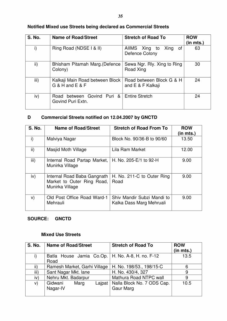
35
Notified Mixed use Streets being declared as Commercial Streets S. No. Name of Road/Street Stretch of Road To ROW
(in mts.) i) Ring Road (NDSE I & II) AIIMS Xing to Xing of
Defence Colony
63
ii) Bhisham Pitamah Marg.(Defence Colony)
Sewa Ngr. Rly. Xing to Ring Road Xing
30
iii) Kalkaji Main Road between Block G & H and E & F
Road between Block G & H and E & F Kalkaji
24
iv) Road between Govind Puri & Govind Puri Extn.
Entire Stretch
24
D Commercial Streets notified on 12.04.2007 by GNCTD
S. No. Name of Road/Street Stretch of Road From To ROW (in mts.)
i)
Malviya Nagar Block No. 90/36-B to 90/60
13.50
ii) Masjid Moth Village Lila Ram Market
12.00
iii) Internal Road Partap Market, Munirka Village
H. No. 205-E/1 to 92-H
9.00
iv) Internal Road Baba Gangnath Market to Outer Ring Road, Munirka Village
H. No. 211-C to Outer Ring Road
9.00
v) Old Post Office Road Ward-1 Mehrauli
Shiv Mandir Subzi Mandi to Kalka Dass Marg Mehruali
9.00
SOURCE: GNCTD
Mixed Use Streets
S. No. Name of Road/Street Stretch of Road To ROW (in mts.)
i) Batla House Jamia Co.Op. Road
H. No. A-8, H. no. F-12 13.5
ii) Ramesh Market, Garhi Village H. No. 198/53., 198/15-C 6 iii) Sant Nagar Mkt. lane H. No. 430/4, 327 9 iv) Nehru Mkt. Badarpur Mathura Road NTPC wall 9 v) Gidwani Marg Lajpat
Nagar-IV
Nalla Block No. 7 ODS Cap. Gaur Marg
10.5
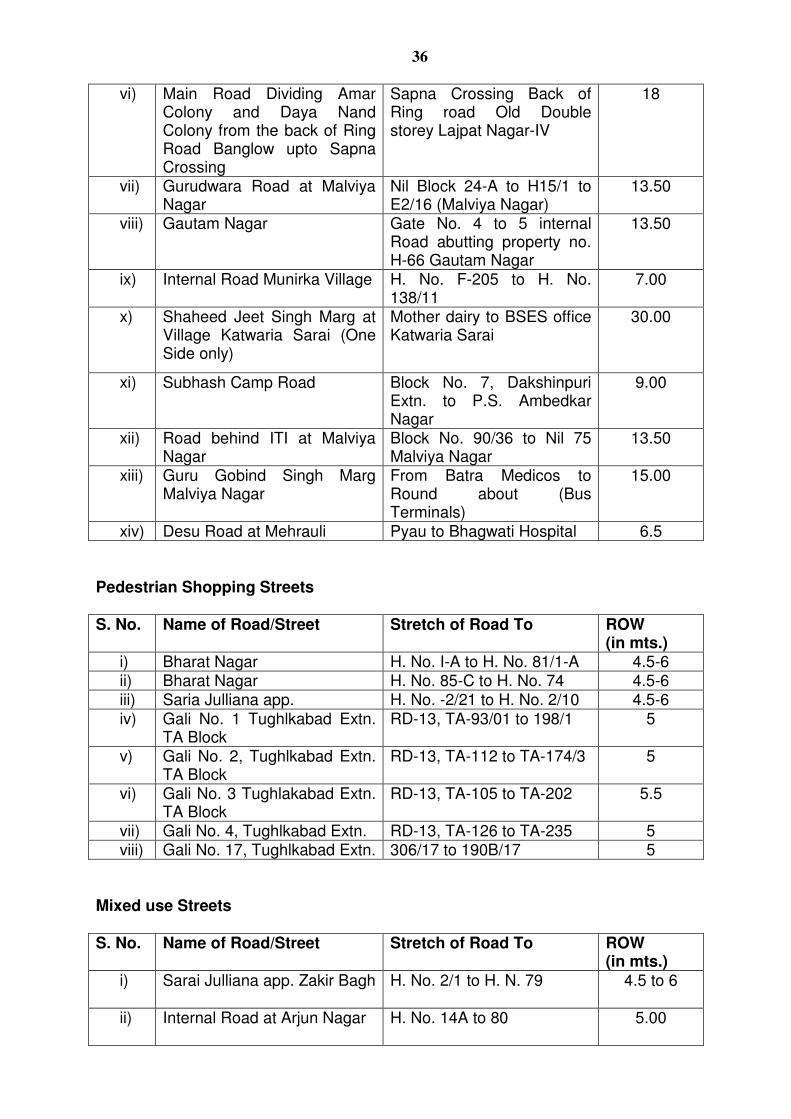
36
vi) Main Road Dividing Amar Colony and Daya Nand Colony from the back of Ring Road Banglow upto Sapna Crossing
Sapna Crossing Back of Ring road Old Double storey Lajpat Nagar-IV
18
vii) Gurudwara Road at Malviya Nagar
Nil Block 24-A to H15/1 to E2/16 (Malviya Nagar)
13.50
viii) Gautam Nagar Gate No. 4 to 5 internal Road abutting property no. H-66 Gautam Nagar
13.50
ix) Internal Road Munirka Village H. No. F-205 to H. No. 138/11
7.00
x) Shaheed Jeet Singh Marg at Village Katwaria Sarai (One Side only)
Mother dairy to BSES office Katwaria Sarai
30.00
xi) Subhash Camp Road Block No. 7, Dakshinpuri Extn. to P.S. Ambedkar Nagar
9.00
xii) Road behind ITI at Malviya Nagar
Block No. 90/36 to Nil 75 Malviya Nagar
13.50
xiii) Guru Gobind Singh Marg Malviya Nagar
From Batra Medicos to Round about (Bus Terminals)
15.00
xiv) Desu Road at Mehrauli Pyau to Bhagwati Hospital 6.5
Pedestrian Shopping Streets S. No. Name of Road/Street Stretch of Road To ROW
(in mts.) i) Bharat Nagar H. No. I-A to H. No. 81/1-A 4.5-6 ii) Bharat Nagar H. No. 85-C to H. No. 74 4.5-6 iii) Saria Julliana app. H. No. -2/21 to H. No. 2/10 4.5-6 iv) Gali No. 1 Tughlkabad Extn.
TA Block RD-13, TA-93/01 to 198/1
5
v) Gali No. 2, Tughlkabad Extn. TA Block
RD-13, TA-112 to TA-174/3 5
vi) Gali No. 3 Tughlakabad Extn. TA Block
RD-13, TA-105 to TA-202 5.5
vii) Gali No. 4, Tughlkabad Extn. RD-13, TA-126 to TA-235 5 viii) Gali No. 17, Tughlkabad Extn. 306/17 to 190B/17 5
Mixed use Streets S. No. Name of Road/Street Stretch of Road To ROW
(in mts.)
i) Sarai Julliana app. Zakir Bagh H. No. 2/1 to H. N. 79
4.5 to 6
ii) Internal Road at Arjun Nagar H. No. 14A to 80
5.00
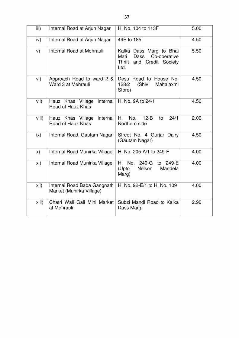
37
iii) Internal Road at Arjun Nagar H. No. 104 to 113F
5.00
iv) Internal Road at Arjun Nagar 49B to 185
4.50
v) Internal Road at Mehrauli Kalka Dass Marg to Bhai Mati Dass Co-operative Thrift and Credit Society Ltd.
5.50
vi) Approach Road to ward 2 & Ward 3 at Mehrauli
Desu Road to House No. 128/2 (Shiv Mahalaxmi Store)
4.50
vii) Hauz Khas Village Internal Road of Hauz Khas
H. No. 9A to 24/1 4.50
viii) Hauz Khas Village Internal Road of Hauz Khas
H. No. 12-B to 24/1 Northern side
2.00
ix) Internal Road, Gautam Nagar Street No. 4 Gurjar Dairy (Gautam Nagar)
4.50
x) Internal Road Munirka Village H. No. 205-A/1 to 249-F
4.00
xi) Internal Road Munirka Village H. No. 249-G to 249-E (Upto Nelson Mandela Marg)
4.00
xii) Internal Road Baba Gangnath Market (Munirka Village)
H. No. 92-E/1 to H. No. 109
4.00
xiii) Chatri Wali Gali Mini Market at Mehrauli
Subzi Mandi Road to Kalka Dass Marg
2.90

38
ANNEXURE – E (Refer 2.8.4)
LIST OF WATER BODIES HAVING AN AREA MORE THAN 1.0 HA. IN ZONE ‘F’ (SOUTH DELHI)-I
1. District Park Hauz Khas 2. District Park Dhuala Kuan 3. Satpula Lake
39
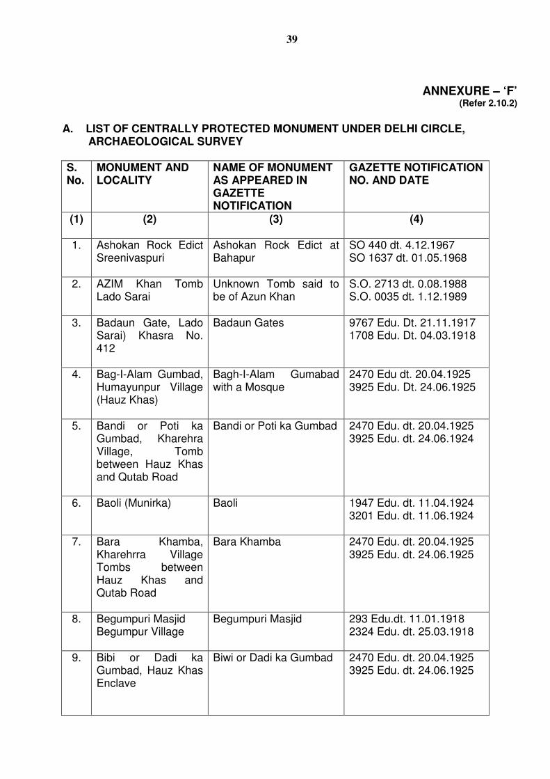
ANNEXURE – ‘F’ (Refer 2.10.2)
A. LIST OF CENTRALLY PROTECTED MONUMENT UNDER DELHI CIRCLE, ARCHAEOLOGICAL SURVEY
S. No.
MONUMENT AND LOCALITY
NAME OF MONUMENT AS APPEARED IN GAZETTE NOTIFICATION
GAZETTE NOTIFICATION NO. AND DATE
(1) (2) (3) (4)
1.
Ashokan Rock Edict Sreenivaspuri
Ashokan Rock Edict at Bahapur
SO 440 dt. 4.12.1967 SO 1637 dt. 01.05.1968
2. AZIM Khan Tomb Lado Sarai
Unknown Tomb said to be of Azun Khan
S.O. 2713 dt. 0.08.1988 S.O. 0035 dt. 1.12.1989
3. Badaun Gate, Lado Sarai) Khasra No. 412
Badaun Gates 9767 Edu. Dt. 21.11.1917 1708 Edu. Dt. 04.03.1918
4. Bag-I-Alam Gumbad, Humayunpur Village (Hauz Khas)
Bagh-I-Alam Gumabad with a Mosque
2470 Edu dt. 20.04.1925 3925 Edu. Dt. 24.06.1925
5. Bandi or Poti ka Gumbad, Kharehra Village, Tomb between Hauz Khas and Qutab Road
Bandi or Poti ka Gumbad 2470 Edu. dt. 20.04.1925 3925 Edu. dt. 24.06.1924
6. Baoli (Munirka) Baoli 1947 Edu. dt. 11.04.1924 3201 Edu. dt. 11.06.1924
7. Bara Khamba, Kharehrra Village Tombs between Hauz Khas and Qutab Road
Bara Khamba 2470 Edu. dt. 20.04.1925 3925 Edu. dt. 24.06.1925
8. Begumpuri Masjid Begumpur Village
Begumpuri Masjid 293 Edu.dt. 11.01.1918 2324 Edu. dt. 25.03.1918
9. Bibi or Dadi ka Gumbad, Hauz Khas Enclave
Biwi or Dadi ka Gumbad 2470 Edu. dt. 20.04.1925 3925 Edu. dt. 24.06.1925
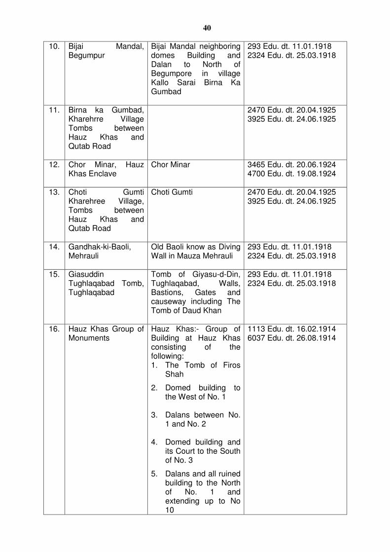
40
10. Bijai Mandal, Begumpur
Bijai Mandal neighboring domes Building and Dalan to North of Begumpore in village Kallo Sarai Birna Ka Gumbad
293 Edu. dt. 11.01.1918 2324 Edu. dt. 25.03.1918
11. Birna ka Gumbad, Kharehrre Village Tombs between Hauz Khas and Qutab Road
2470 Edu. dt. 20.04.1925 3925 Edu. dt. 24.06.1925
12. Chor Minar, Hauz Khas Enclave
Chor Minar 3465 Edu. dt. 20.06.1924 4700 Edu. dt. 19.08.1924
13. Choti Gumti Kharehree Village, Tombs between Hauz Khas and Qutab Road
Choti Gumti 2470 Edu. dt. 20.04.1925 3925 Edu. dt. 24.06.1925
14. Gandhak-ki-Baoli, Mehrauli
Old Baoli know as Diving Wall in Mauza Mehrauli
293 Edu. dt. 11.01.1918 2324 Edu. dt. 25.03.1918
15. Giasuddin Tughlaqabad Tomb, Tughlaqabad
Tomb of Giyasu-d-Din, Tughlaqabad, Walls, Bastions, Gates and causeway including The Tomb of Daud Khan
293 Edu. dt. 11.01.1918 2324 Edu. dt. 25.03.1918
16. Hauz Khas Group of Monuments
Hauz Khas:- Group of Building at Hauz Khas consisting of the following: 1. The Tomb of Firos
Shah 2. Domed building to
the West of No. 1 3. Dalans between No.
1 and No. 2 4. Domed building and
its Court to the South of No. 3
5. Dalans and all ruined
building to the North of No. 1 and extending up to No 10
1113 Edu. dt. 16.02.1914 6037 Edu. dt. 26.08.1914
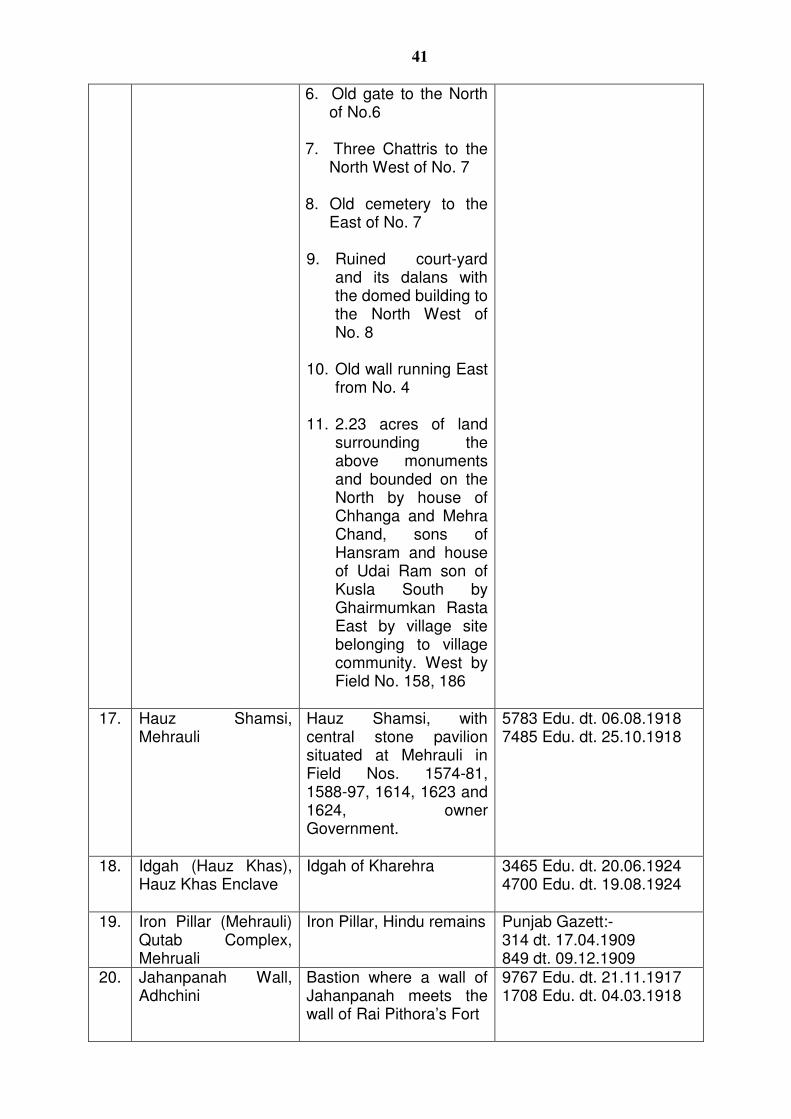
41
6. Old gate to the North of No.6
7. Three Chattris to the
North West of No. 7 8. Old cemetery to the
East of No. 7 9. Ruined court-yard
and its dalans with the domed building to the North West of No. 8
10. Old wall running East
from No. 4 11. 2.23 acres of land
surrounding the above monuments and bounded on the North by house of Chhanga and Mehra Chand, sons of Hansram and house of Udai Ram son of Kusla South by Ghairmumkan Rasta East by village site belonging to village community. West by Field No. 158, 186
17. Hauz Shamsi,
Mehrauli Hauz Shamsi, with central stone pavilion situated at Mehrauli in Field Nos. 1574-81, 1588-97, 1614, 1623 and 1624, owner Government.
5783 Edu. dt. 06.08.1918 7485 Edu. dt. 25.10.1918
18. Idgah (Hauz Khas), Hauz Khas Enclave
Idgah of Kharehra 3465 Edu. dt. 20.06.1924 4700 Edu. dt. 19.08.1924
19. Iron Pillar (Mehrauli) Qutab Complex, Mehruali
Iron Pillar, Hindu remains Punjab Gazett:- 314 dt. 17.04.1909 849 dt. 09.12.1909
20. Jahanpanah Wall, Adhchini
Bastion where a wall of Jahanpanah meets the wall of Rai Pithora’s Fort
9767 Edu. dt. 21.11.1917 1708 Edu. dt. 04.03.1918
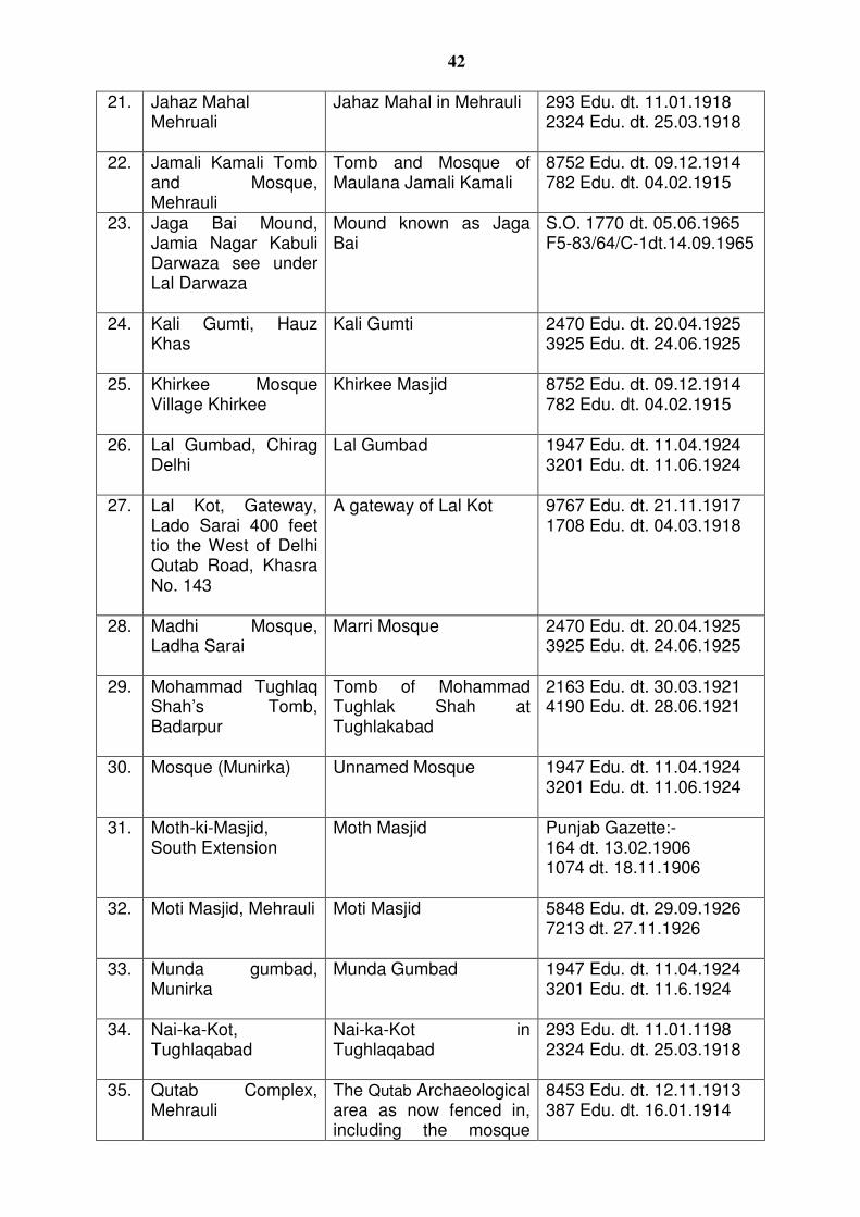
42
21. Jahaz Mahal Mehruali
Jahaz Mahal in Mehrauli 293 Edu. dt. 11.01.1918 2324 Edu. dt. 25.03.1918
22. Jamali Kamali Tomb and Mosque, Mehrauli
Tomb and Mosque of Maulana Jamali Kamali
8752 Edu. dt. 09.12.1914 782 Edu. dt. 04.02.1915
23. Jaga Bai Mound, Jamia Nagar Kabuli Darwaza see under Lal Darwaza
Mound known as Jaga Bai
S.O. 1770 dt. 05.06.1965 F5-83/64/C-1dt.14.09.1965
24. Kali Gumti, Hauz Khas
Kali Gumti 2470 Edu. dt. 20.04.1925 3925 Edu. dt. 24.06.1925
25. Khirkee Mosque Village Khirkee
Khirkee Masjid 8752 Edu. dt. 09.12.1914 782 Edu. dt. 04.02.1915
26. Lal Gumbad, Chirag Delhi
Lal Gumbad 1947 Edu. dt. 11.04.1924 3201 Edu. dt. 11.06.1924
27. Lal Kot, Gateway, Lado Sarai 400 feet tio the West of Delhi Qutab Road, Khasra No. 143
A gateway of Lal Kot 9767 Edu. dt. 21.11.1917 1708 Edu. dt. 04.03.1918
28. Madhi Mosque, Ladha Sarai
Marri Mosque 2470 Edu. dt. 20.04.1925 3925 Edu. dt. 24.06.1925
29. Mohammad Tughlaq Shah’s Tomb, Badarpur
Tomb of Mohammad Tughlak Shah at Tughlakabad
2163 Edu. dt. 30.03.1921 4190 Edu. dt. 28.06.1921
30. Mosque (Munirka) Unnamed Mosque 1947 Edu. dt. 11.04.1924 3201 Edu. dt. 11.06.1924
31. Moth-ki-Masjid, South Extension
Moth Masjid Punjab Gazette:- 164 dt. 13.02.1906 1074 dt. 18.11.1906
32. Moti Masjid, Mehrauli Moti Masjid 5848 Edu. dt. 29.09.1926 7213 dt. 27.11.1926
33. Munda gumbad, Munirka
Munda Gumbad 1947 Edu. dt. 11.04.1924 3201 Edu. dt. 11.6.1924
34. Nai-ka-Kot, Tughlaqabad
Nai-ka-Kot in Tughlaqabad
293 Edu. dt. 11.01.1198 2324 Edu. dt. 25.03.1918
35. Qutab Complex, Mehrauli
The Qutab Archaeological area as now fenced in, including the mosque
8453 Edu. dt. 12.11.1913 387 Edu. dt. 16.01.1914
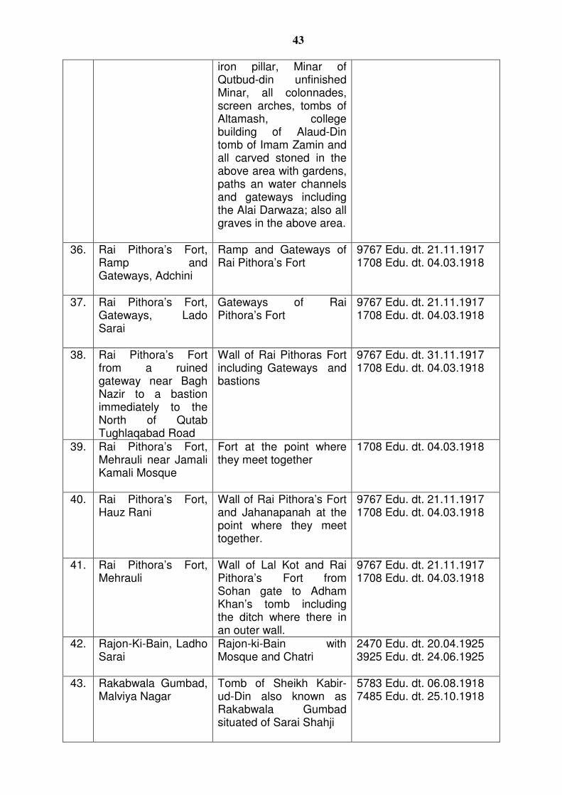
43
iron pillar, Minar of Qutbud-din unfinished Minar, all colonnades, screen arches, tombs of Altamash, college building of Alaud-Din tomb of Imam Zamin and all carved stoned in the above area with gardens, paths an water channels and gateways including the Alai Darwaza; also all graves in the above area.
36. Rai Pithora’s Fort, Ramp and Gateways, Adchini
Ramp and Gateways of Rai Pithora’s Fort
9767 Edu. dt. 21.11.1917 1708 Edu. dt. 04.03.1918
37. Rai Pithora’s Fort, Gateways, Lado Sarai
Gateways of Rai Pithora’s Fort
9767 Edu. dt. 21.11.1917 1708 Edu. dt. 04.03.1918
38. Rai Pithora’s Fort from a ruined gateway near Bagh Nazir to a bastion immediately to the North of Qutab Tughlaqabad Road
Wall of Rai Pithoras Fort including Gateways and bastions
9767 Edu. dt. 31.11.1917 1708 Edu. dt. 04.03.1918
39. Rai Pithora’s Fort, Mehrauli near Jamali Kamali Mosque
Fort at the point where they meet together
1708 Edu. dt. 04.03.1918
40. Rai Pithora’s Fort, Hauz Rani
Wall of Rai Pithora’s Fort and Jahanapanah at the point where they meet together.
9767 Edu. dt. 21.11.1917 1708 Edu. dt. 04.03.1918
41. Rai Pithora’s Fort, Mehrauli
Wall of Lal Kot and Rai Pithora’s Fort from Sohan gate to Adham Khan’s tomb including the ditch where there in an outer wall.
9767 Edu. dt. 21.11.1917 1708 Edu. dt. 04.03.1918
42. Rajon-Ki-Bain, Ladho Sarai
Rajon-ki-Bain with Mosque and Chatri
2470 Edu. dt. 20.04.1925 3925 Edu. dt. 24.06.1925
43. Rakabwala Gumbad, Malviya Nagar
Tomb of Sheikh Kabir-ud-Din also known as Rakabwala Gumbad situated of Sarai Shahji
5783 Edu. dt. 06.08.1918 7485 Edu. dt. 25.10.1918
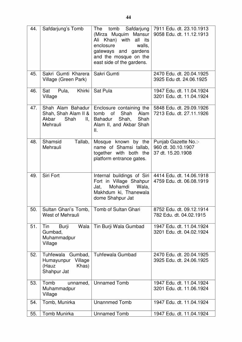
44
44. Safdarjung’s Tomb The tomb Safdarjung (Mirza Muquim Mansur Ali Khan) with all its enclosure walls, gateways and gardens and the mosque on the east side of the gardens.
7911 Edu. dt. 23.10.1913 9058 Edu. dt. 11.12.1913
45. Sakri Gumti Kharera Village (Green Park)
Sakri Gumti 2470 Edu. dt. 20.04.1925 3925 Edu dt. 24.06.1925
46. Sat Pula, Khirki Village
Sat Pula 1947 Edu. dt. 11.04.1924 3201 Edu. dt. 11.04.1924
47. Shah Alam Bahadur Shah, Shah Alam II & Akbar Shah II, Mehrauli
Enclosure containing the tomb of Shah Alam Bahadur Shah, Shah Alam II, and Akbar Shah II.
5848 Edu. dt. 29.09.1926 7213 Edu. dt. 27.11.1926
48. Shamsid Tallab, Mehrauli
Mosque known by the name of Shamsi tallab, together with both the platform entrance gates.
Punjab Gazette No.:- 960 dt. 30.10.1907 37 dt. 15.20.1908
49. Siri Fort Internal buildings of Siri Fort in Village Shahpur Jat, Mohamdi Wala, Makhdum ki, Thanewala dome Shahpur Jat
4414 Edu. dt. 14.06.1918 4759 Edu. dt. 06.08.1919
50. Sultan Ghari’s Tomb, West of Mehrauli
Tomb of Sultan Ghari 8752 Edu. dt. 09.12.1914 782 Edu. dt. 04.02.1915
51. Tin Burji Wala Gumbad, Muhammadpur Village
Tin Burji Wala Gumbad 1947 Edu. dt. 11.04.1924 3201 Edu. dt. 04.02.1924
52. Tuhfewala Gumbad, Humayunpur Village (Hauz Khas) Shahpur Jat
Tuhfewala Gumbad 2470 Edu. dt. 20.04.1925 3925 Edu. dt. 24.06.1925
53. Tomb unnamed, Muhammadpur Village
Unnamed Tomb 1947 Edu. dt. 11.04.1924 3201 Edu. dt. 11.06.1924
54. Tomb, Munirka Unannmed Tomb 1947 Edu. dt. 11.04.1924
55. Tomb Munirka Unnamed Tomb 1947 Edu. dt. 11.04.1924
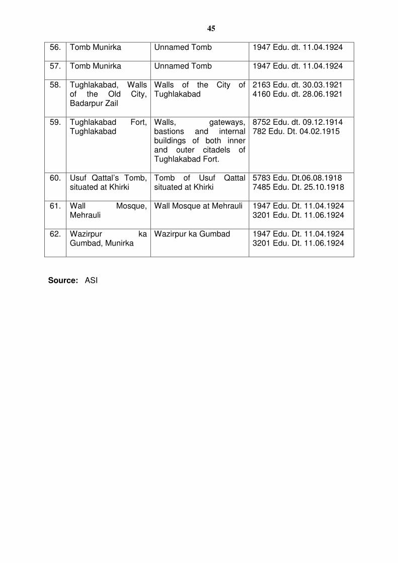
45
56. Tomb Munirka Unnamed Tomb 1947 Edu. dt. 11.04.1924
57. Tomb Munirka Unnamed Tomb 1947 Edu. dt. 11.04.1924
58. Tughlakabad, Walls of the Old City, Badarpur Zail
Walls of the City of Tughlakabad
2163 Edu. dt. 30.03.1921 4160 Edu. dt. 28.06.1921
59. Tughlakabad Fort, Tughlakabad
Walls, gateways, bastions and internal buildings of both inner and outer citadels of Tughlakabad Fort.
8752 Edu. dt. 09.12.1914 782 Edu. Dt. 04.02.1915
60. Usuf Qattal’s Tomb, situated at Khirki
Tomb of Usuf Qattal situated at Khirki
5783 Edu. Dt.06.08.1918 7485 Edu. Dt. 25.10.1918
61. Wall Mosque, Mehrauli
Wall Mosque at Mehrauli 1947 Edu. Dt. 11.04.1924 3201 Edu. Dt. 11.06.1924
62. Wazirpur ka Gumbad, Munirka
Wazirpur ka Gumbad 1947 Edu. Dt. 11.04.1924 3201 Edu. Dt. 11.06.1924
Source: ASI
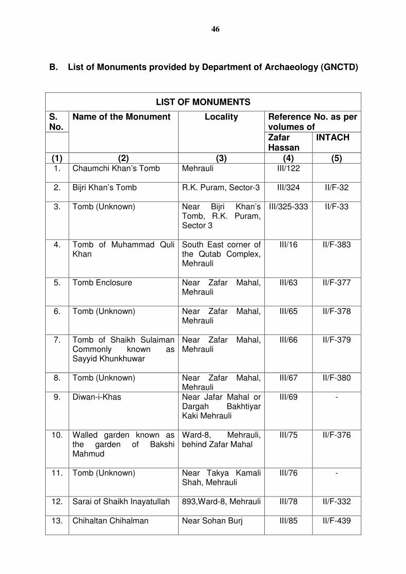
46
B. List of Monuments provided by Department of Archaeology (GNCTD)
LIST OF MONUMENTS
S. No.
Name of the Monument Locality Reference No. as per volumes of
Zafar Hassan
INTACH
(1) (2) (3) (4) (5) 1. Chaumchi Khan’s Tomb Mehrauli III/122
2. Bijri Khan’s Tomb R.K. Puram, Sector-3
III/324 II/F-32
3. Tomb (Unknown) Near Bijri Khan’s Tomb, R.K. Puram, Sector 3
III/325-333 II/F-33
4. Tomb of Muhammad Quli Khan
South East corner of the Qutab Complex, Mehrauli
III/16 II/F-383
5. Tomb Enclosure Near Zafar Mahal, Mehrauli
III/63 II/F-377
6. Tomb (Unknown) Near Zafar Mahal, Mehrauli
III/65 II/F-378
7. Tomb of Shaikh Sulaiman Commonly known as Sayyid Khunkhuwar
Near Zafar Mahal, Mehrauli
III/66 II/F-379
8. Tomb (Unknown) Near Zafar Mahal, Mehrauli
III/67 II/F-380
9. Diwan-i-Khas Near Jafar Mahal or Dargah Bakhtiyar Kaki Mehrauli
III/69 -
10. Walled garden known as the garden of Bakshi Mahmud
Ward-8, Mehrauli, behind Zafar Mahal
III/75 II/F-376
11. Tomb (Unknown) Near Takya Kamali Shah, Mehrauli
III/76 -
12. Sarai of Shaikh Inayatullah 893,Ward-8, Mehrauli
III/78 II/F-332
13. Chihaltan Chihalman Near Sohan Burj
III/85 II/F-439
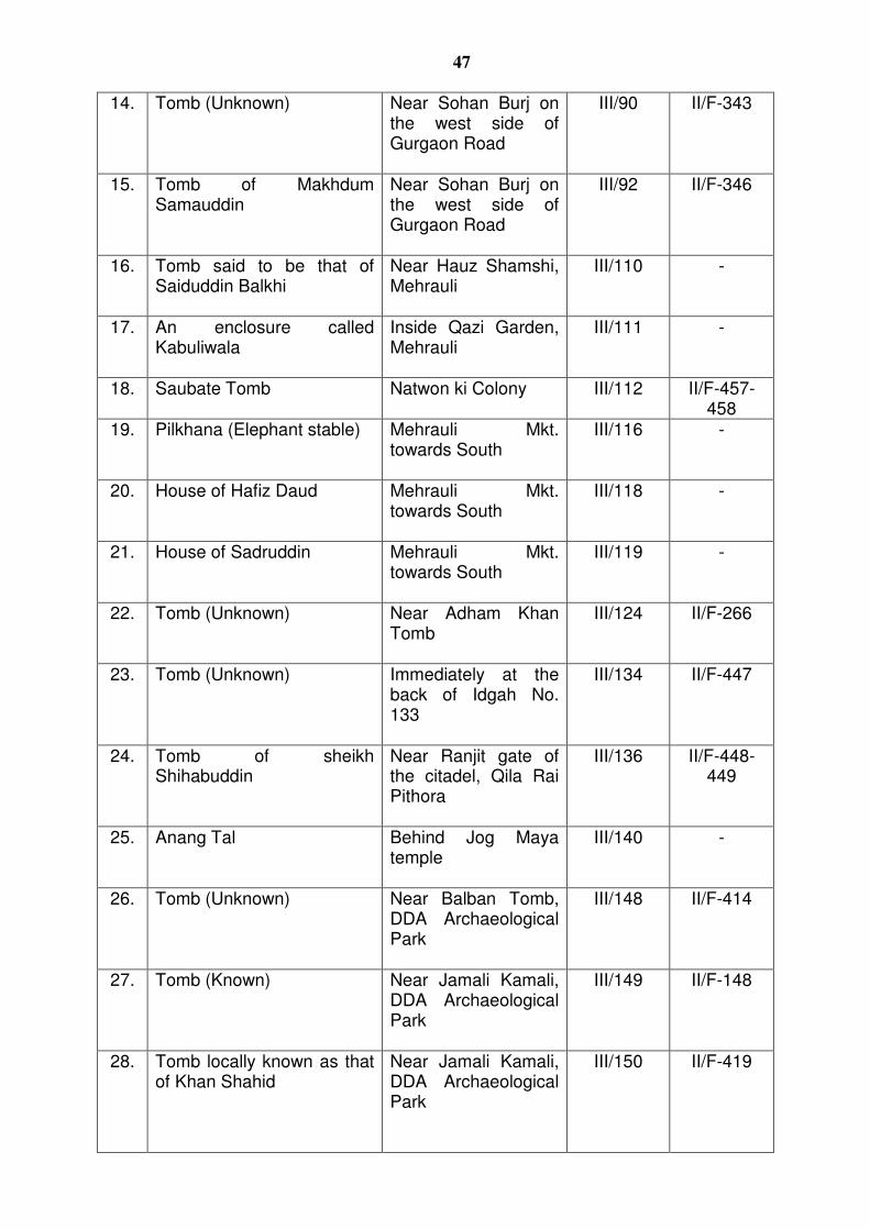
47
14. Tomb (Unknown) Near Sohan Burj on the west side of Gurgaon Road
III/90 II/F-343
15. Tomb of Makhdum Samauddin
Near Sohan Burj on the west side of Gurgaon Road
III/92 II/F-346
16. Tomb said to be that of Saiduddin Balkhi
Near Hauz Shamshi, Mehrauli
III/110 -
17. An enclosure called Kabuliwala
Inside Qazi Garden, Mehrauli
III/111 -
18. Saubate Tomb Natwon ki Colony III/112 II/F-457-458
19. Pilkhana (Elephant stable) Mehrauli Mkt. towards South
III/116 -
20. House of Hafiz Daud Mehrauli Mkt. towards South
III/118 -
21. House of Sadruddin Mehrauli Mkt. towards South
III/119 -
22. Tomb (Unknown) Near Adham Khan Tomb
III/124 II/F-266
23. Tomb (Unknown) Immediately at the back of Idgah No. 133
III/134 II/F-447
24. Tomb of sheikh Shihabuddin
Near Ranjit gate of the citadel, Qila Rai Pithora
III/136 II/F-448-449
25. Anang Tal Behind Jog Maya temple
III/140 -
26. Tomb (Unknown) Near Balban Tomb, DDA Archaeological Park
III/148 II/F-414
27. Tomb (Known) Near Jamali Kamali, DDA Archaeological Park
III/149 II/F-148
28. Tomb locally known as that of Khan Shahid
Near Jamali Kamali, DDA Archaeological Park
III/150 II/F-419
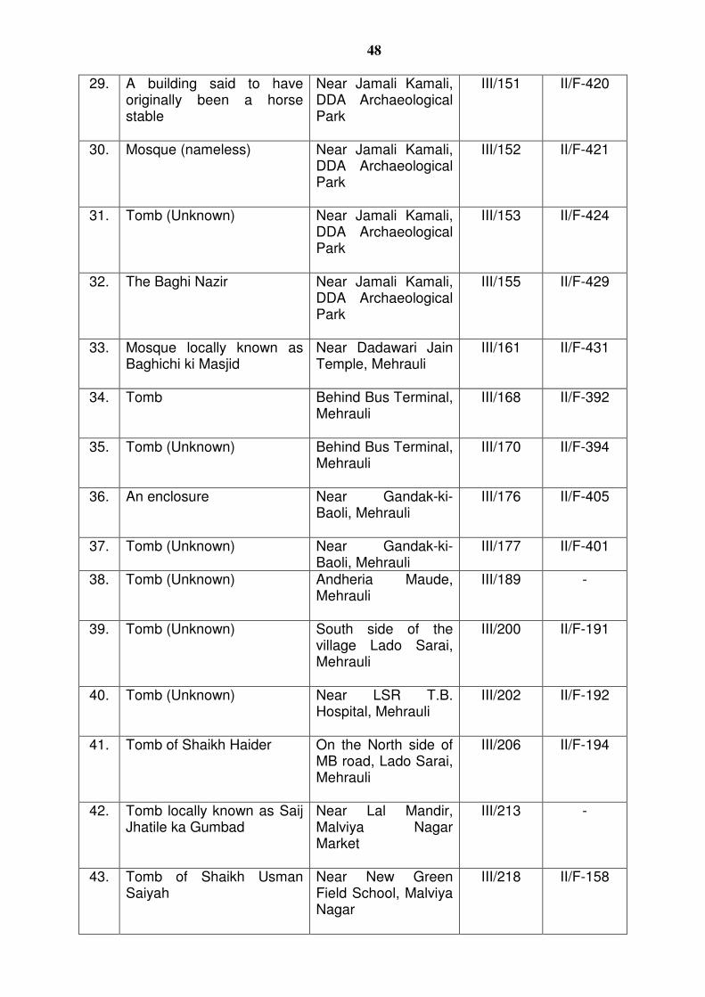
48
29. A building said to have originally been a horse stable
Near Jamali Kamali, DDA Archaeological Park
III/151 II/F-420
30. Mosque (nameless) Near Jamali Kamali, DDA Archaeological Park
III/152 II/F-421
31. Tomb (Unknown) Near Jamali Kamali, DDA Archaeological Park
III/153 II/F-424
32. The Baghi Nazir Near Jamali Kamali, DDA Archaeological Park
III/155 II/F-429
33. Mosque locally known as Baghichi ki Masjid
Near Dadawari Jain Temple, Mehrauli
III/161 II/F-431
34. Tomb Behind Bus Terminal, Mehrauli
III/168 II/F-392
35. Tomb (Unknown) Behind Bus Terminal, Mehrauli
III/170 II/F-394
36. An enclosure Near Gandak-ki-Baoli, Mehrauli
III/176 II/F-405
37. Tomb (Unknown) Near Gandak-ki-Baoli, Mehrauli
III/177 II/F-401
38. Tomb (Unknown) Andheria Maude, Mehrauli
III/189 -
39. Tomb (Unknown) South side of the village Lado Sarai, Mehrauli
III/200 II/F-191
40. Tomb (Unknown) Near LSR T.B. Hospital, Mehrauli
III/202 II/F-192
41. Tomb of Shaikh Haider On the North side of MB road, Lado Sarai, Mehrauli
III/206 II/F-194
42. Tomb locally known as Saij Jhatile ka Gumbad
Near Lal Mandir, Malviya Nagar Market
III/213 -
43. Tomb of Shaikh Usman Saiyah
Near New Green Field School, Malviya Nagar
III/218 II/F-158
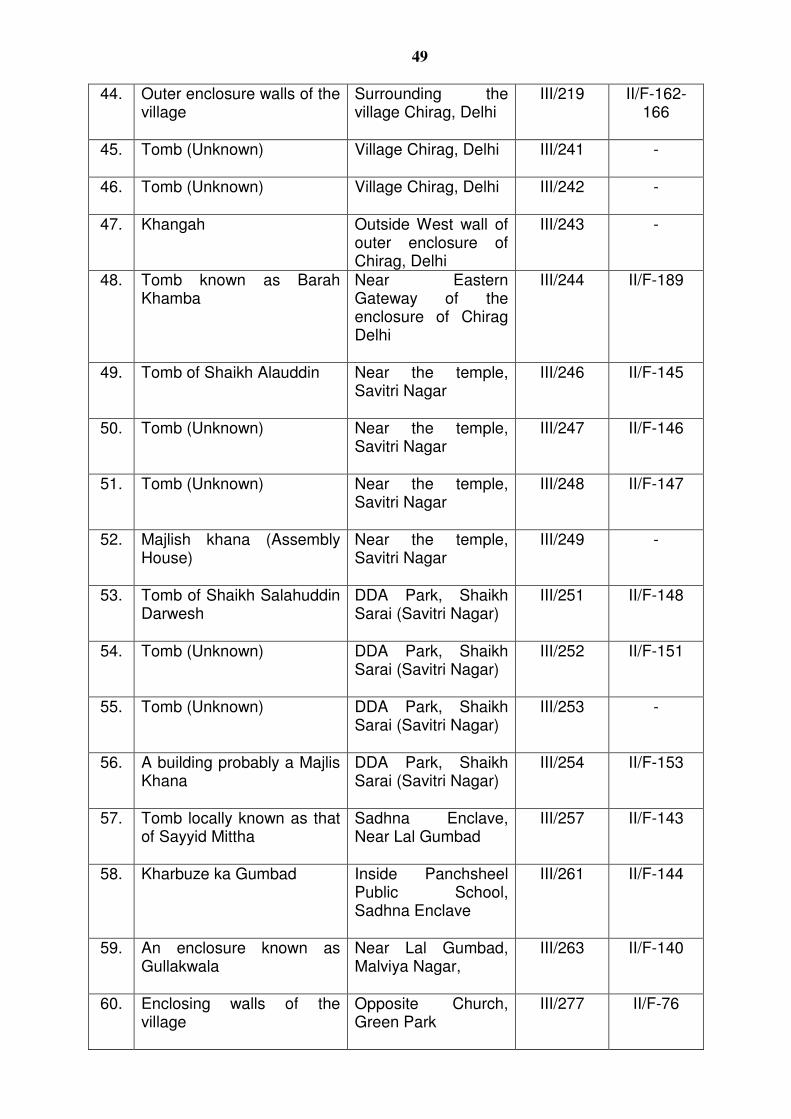
49
44. Outer enclosure walls of the village
Surrounding the village Chirag, Delhi
III/219 II/F-162-166
45. Tomb (Unknown) Village Chirag, Delhi
III/241 -
46. Tomb (Unknown) Village Chirag, Delhi
III/242 -
47. Khangah Outside West wall of outer enclosure of Chirag, Delhi
III/243 -
48. Tomb known as Barah Khamba
Near Eastern Gateway of the enclosure of Chirag Delhi
III/244 II/F-189
49. Tomb of Shaikh Alauddin Near the temple, Savitri Nagar
III/246 II/F-145
50. Tomb (Unknown) Near the temple, Savitri Nagar
III/247 II/F-146
51. Tomb (Unknown) Near the temple, Savitri Nagar
III/248 II/F-147
52. Majlish khana (Assembly House)
Near the temple, Savitri Nagar
III/249 -
53. Tomb of Shaikh Salahuddin Darwesh
DDA Park, Shaikh Sarai (Savitri Nagar)
III/251 II/F-148
54. Tomb (Unknown) DDA Park, Shaikh Sarai (Savitri Nagar)
III/252 II/F-151
55. Tomb (Unknown) DDA Park, Shaikh Sarai (Savitri Nagar)
III/253 -
56. A building probably a Majlis Khana
DDA Park, Shaikh Sarai (Savitri Nagar)
III/254 II/F-153
57. Tomb locally known as that of Sayyid Mittha
Sadhna Enclave, Near Lal Gumbad
III/257 II/F-143
58. Kharbuze ka Gumbad Inside Panchsheel Public School, Sadhna Enclave
III/261 II/F-144
59. An enclosure known as Gullakwala
Near Lal Gumbad, Malviya Nagar,
III/263 II/F-140
60. Enclosing walls of the village
Opposite Church, Green Park
III/277 II/F-76
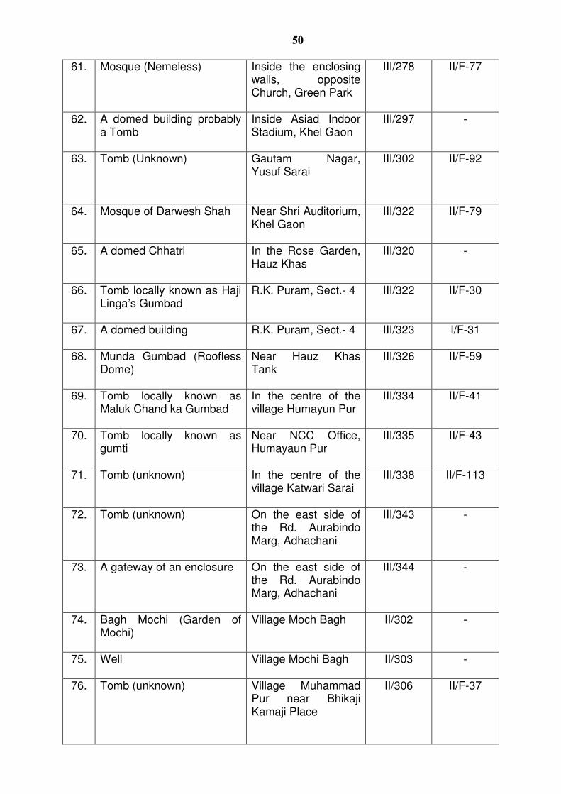
50
61. Mosque (Nemeless) Inside the enclosing walls, opposite Church, Green Park
III/278 II/F-77
62. A domed building probably a Tomb
Inside Asiad Indoor Stadium, Khel Gaon
III/297 -
63. Tomb (Unknown) Gautam Nagar, Yusuf Sarai
III/302 II/F-92
64. Mosque of Darwesh Shah Near Shri Auditorium, Khel Gaon
III/322 II/F-79
65. A domed Chhatri In the Rose Garden, Hauz Khas
III/320 -
66. Tomb locally known as Haji Linga’s Gumbad
R.K. Puram, Sect.- 4
III/322 II/F-30
67. A domed building R.K. Puram, Sect.- 4
III/323 I/F-31
68. Munda Gumbad (Roofless Dome)
Near Hauz Khas Tank
III/326 II/F-59
69. Tomb locally known as Maluk Chand ka Gumbad
In the centre of the village Humayun Pur
III/334 II/F-41
70. Tomb locally known as gumti
Near NCC Office, Humayaun Pur
III/335 II/F-43
71. Tomb (unknown) In the centre of the village Katwari Sarai
III/338 II/F-113
72. Tomb (unknown) On the east side of the Rd. Aurabindo Marg, Adhachani
III/343 -
73. A gateway of an enclosure On the east side of the Rd. Aurabindo Marg, Adhachani
III/344 -
74. Bagh Mochi (Garden of Mochi)
Village Moch Bagh II/302 -
75. Well Village Mochi Bagh
II/303 -
76. Tomb (unknown) Village Muhammad Pur near Bhikaji Kamaji Place
II/306 II/F-37
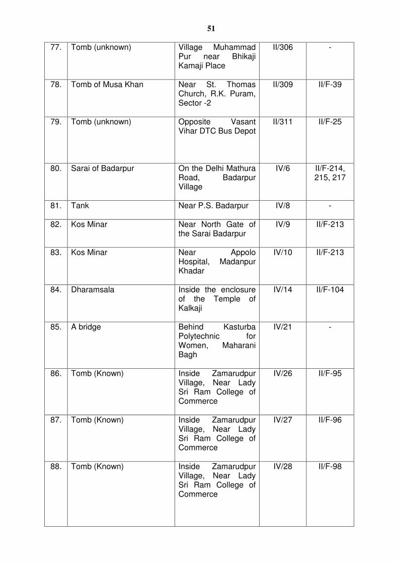
51
77. Tomb (unknown) Village Muhammad Pur near Bhikaji Kamaji Place
II/306 -
78. Tomb of Musa Khan Near St. Thomas Church, R.K. Puram, Sector -2
II/309 II/F-39
79. Tomb (unknown) Opposite Vasant Vihar DTC Bus Depot
II/311 II/F-25
80. Sarai of Badarpur On the Delhi Mathura Road, Badarpur Village
IV/6 II/F-214, 215, 217
81. Tank Near P.S. Badarpur
IV/8 -
82. Kos Minar Near North Gate of the Sarai Badarpur
IV/9 II/F-213
83. Kos Minar Near Appolo Hospital, Madanpur Khadar
IV/10 II/F-213
84. Dharamsala Inside the enclosure of the Temple of Kalkaji
IV/14 II/F-104
85. A bridge Behind Kasturba Polytechnic for Women, Maharani Bagh
IV/21 -
86. Tomb (Known) Inside Zamarudpur Village, Near Lady Sri Ram College of Commerce
IV/26 II/F-95
87. Tomb (Known) Inside Zamarudpur Village, Near Lady Sri Ram College of Commerce
IV/27 II/F-96
88. Tomb (Known) Inside Zamarudpur Village, Near Lady Sri Ram College of Commerce
IV/28 II/F-98
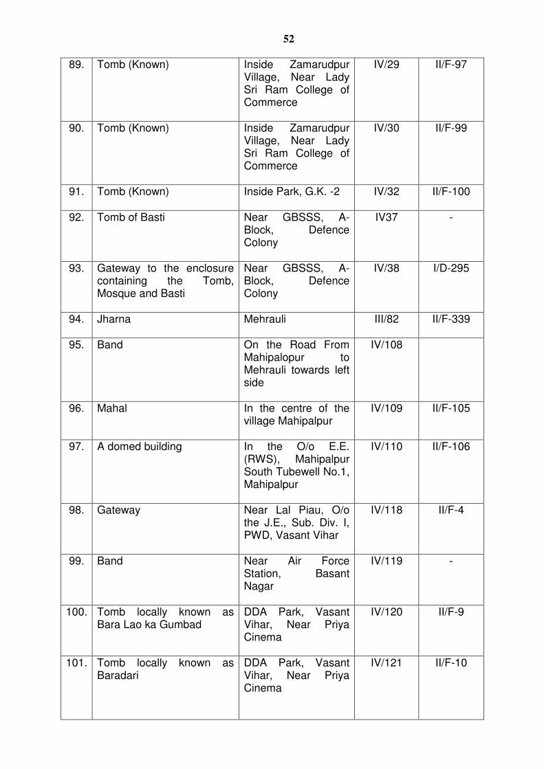
52
89. Tomb (Known) Inside Zamarudpur Village, Near Lady Sri Ram College of Commerce
IV/29 II/F-97
90. Tomb (Known) Inside Zamarudpur Village, Near Lady Sri Ram College of Commerce
IV/30 II/F-99
91. Tomb (Known) Inside Park, G.K. -2
IV/32 II/F-100
92. Tomb of Basti Near GBSSS, A-Block, Defence Colony
IV37 -
93. Gateway to the enclosure containing the Tomb, Mosque and Basti
Near GBSSS, A-Block, Defence Colony
IV/38 I/D-295
94. Jharna Mehrauli
III/82 II/F-339
95. Band On the Road From Mahipalopur to Mehrauli towards left side
IV/108
96. Mahal In the centre of the village Mahipalpur
IV/109 II/F-105
97. A domed building In the O/o E.E. (RWS), Mahipalpur South Tubewell No.1, Mahipalpur
IV/110 II/F-106
98. Gateway Near Lal Piau, O/o the J.E., Sub. Div. I, PWD, Vasant Vihar
IV/118 II/F-4
99. Band Near Air Force Station, Basant Nagar
IV/119 -
100. Tomb locally known as Bara Lao ka Gumbad
DDA Park, Vasant Vihar, Near Priya Cinema
IV/120 II/F-9
101. Tomb locally known as Baradari
DDA Park, Vasant Vihar, Near Priya Cinema
IV/121 II/F-10
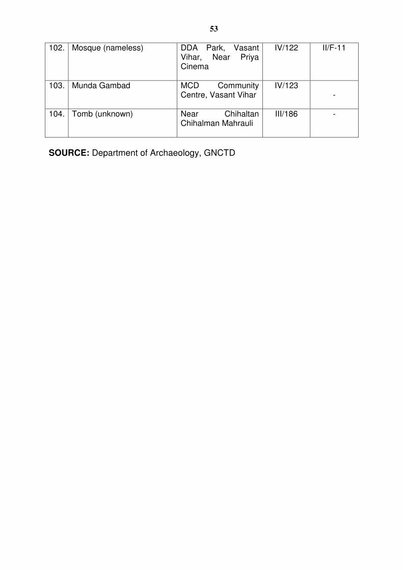
53
102. Mosque (nameless) DDA Park, Vasant Vihar, Near Priya Cinema
IV/122 II/F-11
103.
Munda Gambad MCD Community Centre, Vasant Vihar
IV/123 -
104. Tomb (unknown) Near Chihaltan Chihalman Mahrauli
III/186 -
SOURCE: Department of Archaeology, GNCTD
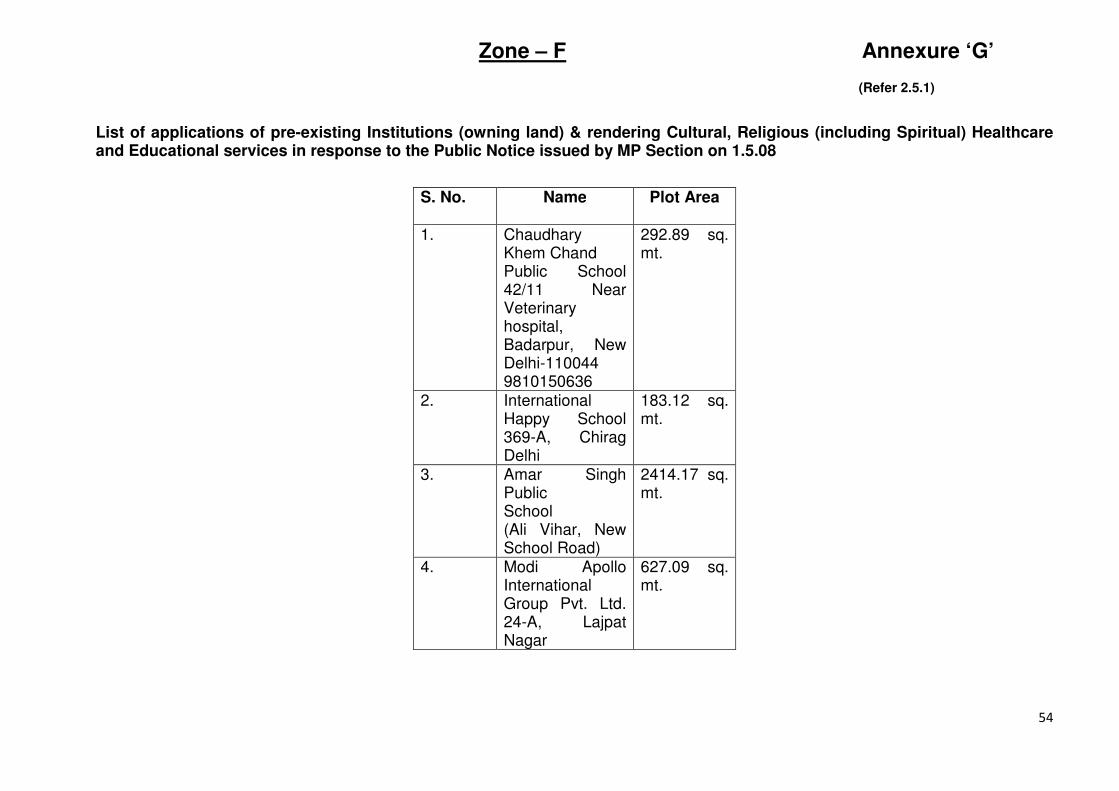
54
Zone – F Annexure ‘G’
(Refer 2.5.1)
List of applications of pre-existing Institutions (owning land) & rendering Cultural, Religious (including Spiritual) Healthcare and Educational services in response to the Public Notice issued by MP Section on 1.5.08
S. No.
Name Plot Area
1. Chaudhary Khem Chand Public School 42/11 Near Veterinary hospital, Badarpur, New Delhi-110044 9810150636
292.89 sq. mt.
2. International Happy School 369-A, Chirag Delhi
183.12 sq. mt.
3. Amar Singh Public School (Ali Vihar, New School Road)
2414.17 sq. mt.
4. Modi Apollo International Group Pvt. Ltd. 24-A, Lajpat Nagar
627.09 sq. mt.
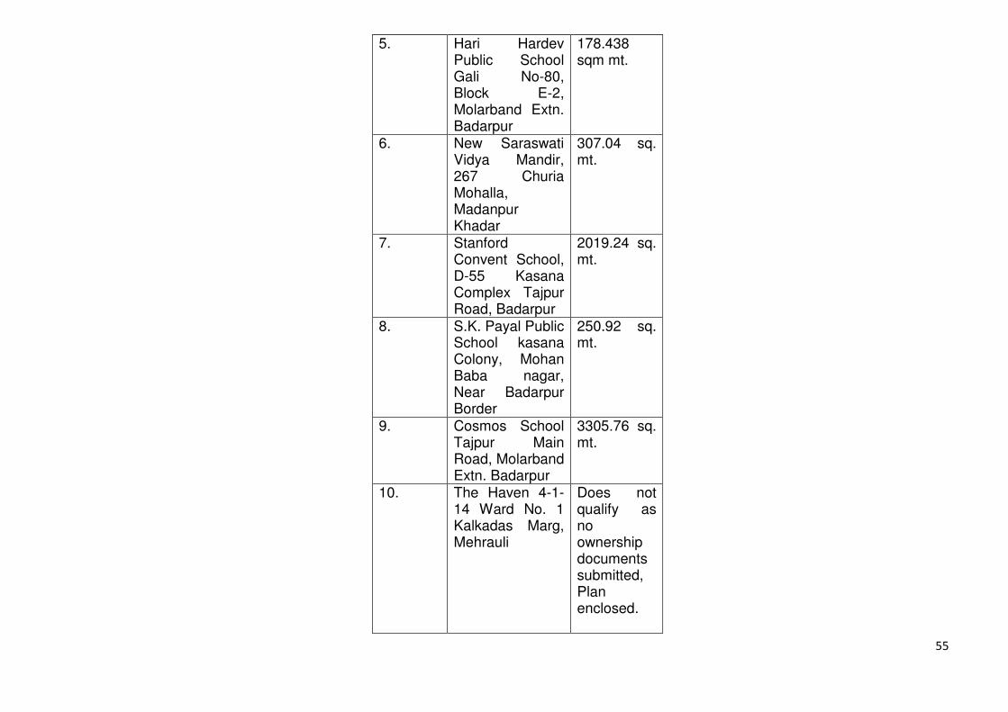
55
5. Hari Hardev Public School Gali No-80, Block E-2, Molarband Extn. Badarpur
178.438 sqm mt.
6. New Saraswati Vidya Mandir, 267 Churia Mohalla, Madanpur Khadar
307.04 sq. mt.
7. Stanford Convent School, D-55 Kasana Complex Tajpur Road, Badarpur
2019.24 sq. mt.
8. S.K. Payal Public School kasana Colony, Mohan Baba nagar, Near Badarpur Border
250.92 sq. mt.
9. Cosmos School Tajpur Main Road, Molarband Extn. Badarpur
3305.76 sq. mt.
10. The Haven 4-1-14 Ward No. 1 Kalkadas Marg, Mehrauli
Does not qualify as no ownership documents submitted, Plan enclosed.
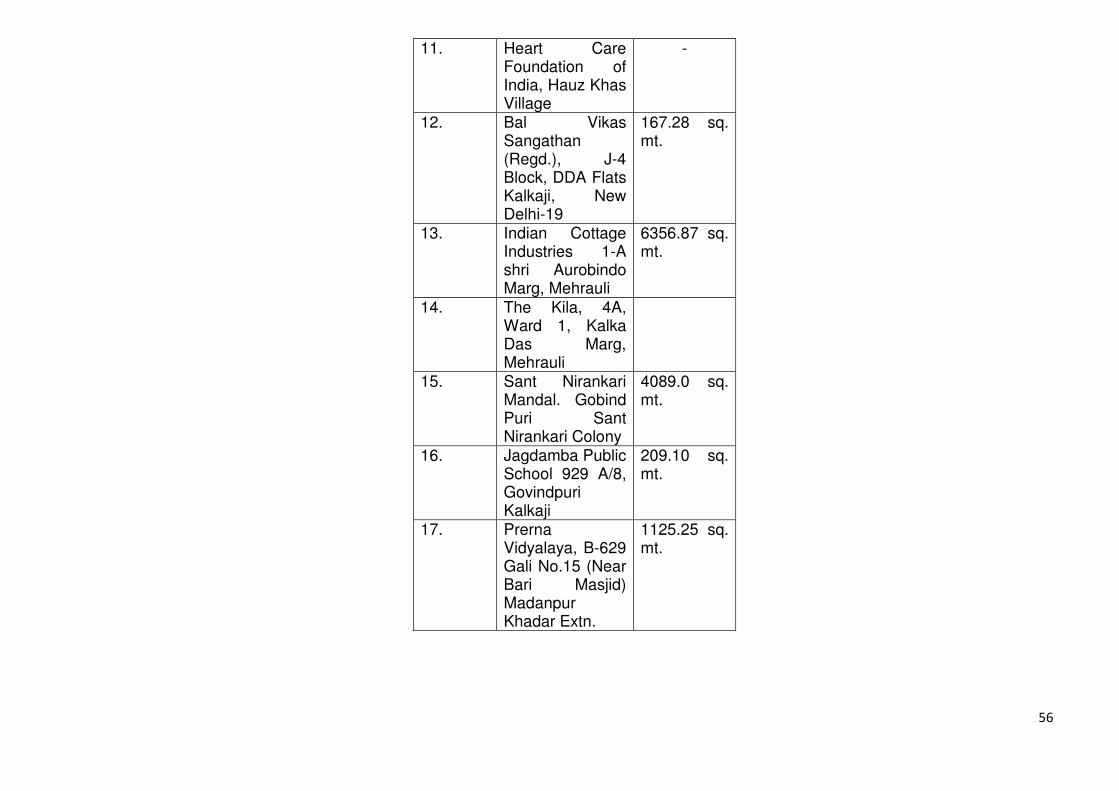
56
11. Heart Care Foundation of India, Hauz Khas Village
-
12. Bal Vikas Sangathan (Regd.), J-4 Block, DDA Flats Kalkaji, New Delhi-19
167.28 sq. mt.
13. Indian Cottage Industries 1-A shri Aurobindo Marg, Mehrauli
6356.87 sq. mt.
14. The Kila, 4A, Ward 1, Kalka Das Marg, Mehrauli
15. Sant Nirankari Mandal. Gobind Puri Sant Nirankari Colony
4089.0 sq. mt.
16. Jagdamba Public School 929 A/8, Govindpuri Kalkaji
209.10 sq. mt.
17. Prerna Vidyalaya, B-629 Gali No.15 (Near Bari Masjid) Madanpur Khadar Extn.
1125.25 sq. mt.
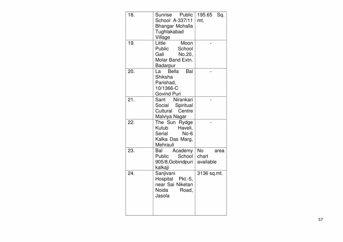
57
18. Sunrise Public School A-337/11 Bhangar Mohalla Tughlakabad Village
195.65 Sq. mt.
19. Little Moon Public School Gali No.20, Molar Band Extn. Badarpur
-
20. La Bella Bal Shiksha Parishad, 10/1366-C Govind Puri
-
21. Sant Nirankari Social Spiritual Cultural Centre Malviya Nagar
-
22. The Sun Rydge Kutub Haveli, Serial No-6 Kalka Das Marg, Mehrauli
-
23. Bal Academy Public School 905/8,Gobindpuri kalkaji
No area chart available
24. Sanjivani Hospital Pkt.-5, near Sai Niketan Noida Road, Jasola
3136 sq.mt.
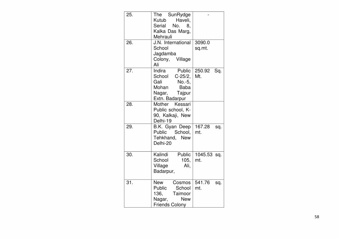
58
25. The SunRydge Kutub Haveli, Serial No. 8, Kalka Das Marg, Mehrauli
-
26. J.N. International School Jagdamba Colony, Village Ali
3090.0 sq.mt.
27. Indira Public School C-25/2, Gali No.-5, Mohan Baba Nagar, Tajpur Extn. Badarpur
250.92 Sq. Mt.
28. Mother Kessari Public school, K-90, Kalkaji, New Delhi-19
29. B.K. Gyan Deep Public School, Tehkhand, New Delhi-20
167.28 sq. mt.
30. Kalindi Public School 105, Village Ali, Badarpur,
1045.53 sq. mt.
31. New Cosmos Public School 136, Taimoor Nagar, New Friends Colony
541.76 sq. mt.
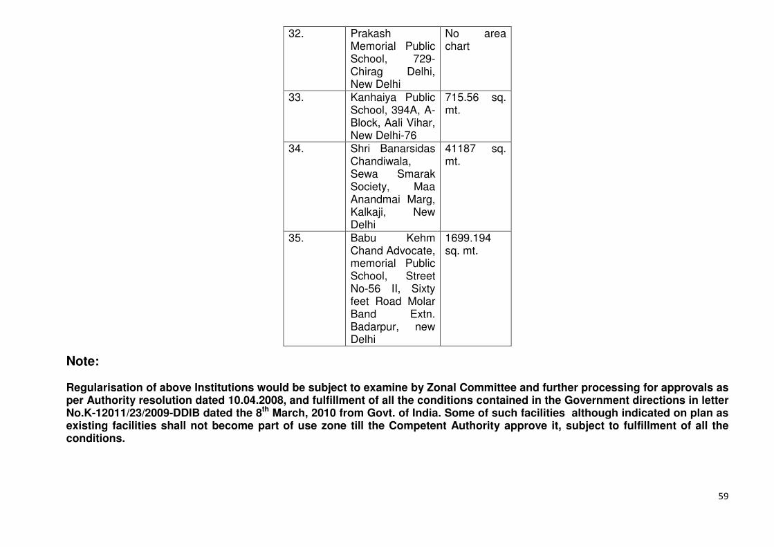
59
32. Prakash Memorial Public School, 729-Chirag Delhi, New Delhi
No area chart
33. Kanhaiya Public School, 394A, A- Block, Aali Vihar, New Delhi-76
715.56 sq. mt.
34. Shri Banarsidas Chandiwala, Sewa Smarak Society, Maa Anandmai Marg, Kalkaji, New Delhi
41187 sq. mt.
35. Babu Kehm Chand Advocate, memorial Public School, Street No-56 II, Sixty feet Road Molar Band Extn. Badarpur, new Delhi
1699.194 sq. mt.
Note: Regularisation of above Institutions would be subject to examine by Zonal Committee and further processing for approvals as per Authority resolution dated 10.04.2008, and fulfillment of all the conditions contained in the Government directions in letter No.K-12011/23/2009-DDIB dated the 8th March, 2010 from Govt. of India. Some of such facilities although indicated on plan as existing facilities shall not become part of use zone till the Competent Authority approve it, subject to fulfillment of all the conditions.
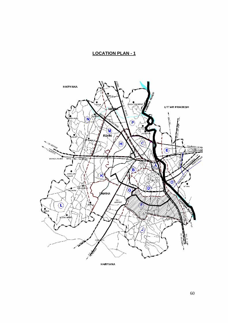
60
LOCATION PLAN - 1