Embed Size (px)
Citation preview

ZONING MAP CHANGE REPORT
2720 FAUCETTE AVE Z1900021
Page 1 of 5
Meeting Date: July 21, 2020
A. Summary
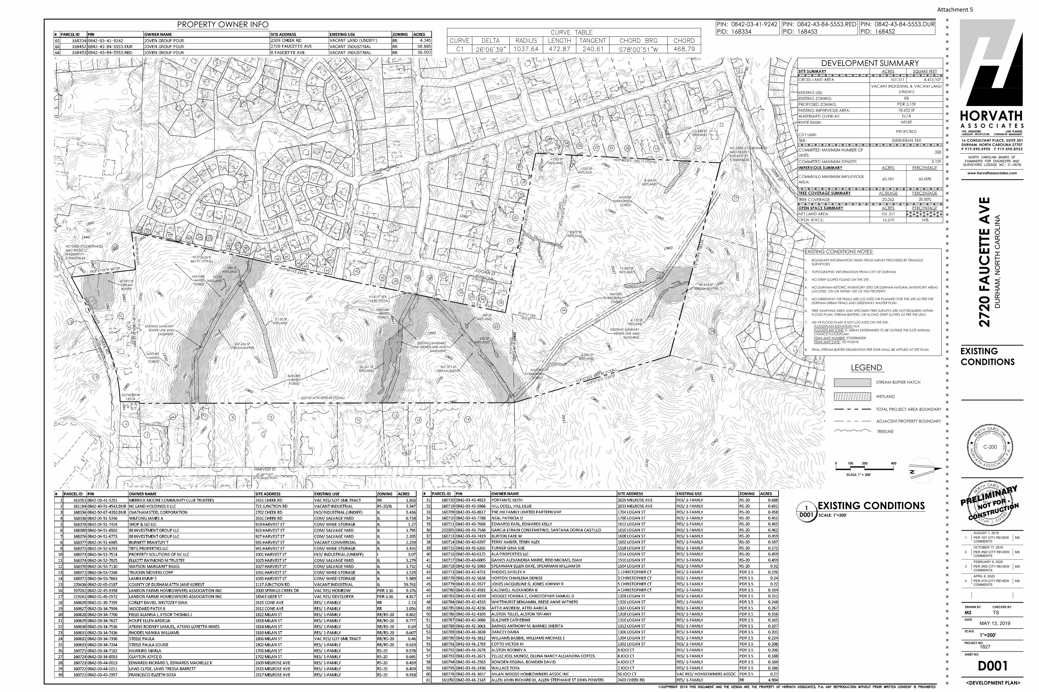
Tim Sivers of Horvath Associates, proposes to change the zoning designation of three parcels located generally at 2720 Faucette Avenue. The site is presently zoned Residential Rural (RR) and the applicant proposes to change this designation to Planned Development Residential 3.159 (PDR 3.159). The development plan associated with this request commits to a maximum of 320 single family detached and townhouse residential units and permitted accessory uses with a minimum of 20 percent of each unit type. The property is Low Density Residential on the Future Land Use Map (FLUM) which is consistent with the rezoning request for PDR 3.159. An annexation petition has been submitted for the 36.171 acre portion of the site that is not within the existing city limits.
Application Summary Application Information Reference Name 2720 Faucette Ave Submittal Date April 13, 2019 Application Type(s) (Case#) Zoning Map Change (Z1900021), Annexation (BDG1900012) Proposal Up to 320 single family detached and townhouse residential units
Applicant Tim Sivers, Horvath Associates Staff Contact Emily Struthers, Senior Planner ([email protected]) Site Information
Location 2720 Faucette Ave, 1035 Junction Road, and 2509 Cheek Road Legacy Cases N/A
Site Acreage 101.311 Existing Use Undeveloped Request
Designations Existing Proposed
Jurisdiction City/ County City
Development Tier Suburban No change
Future Land Use Low Density Residential No change
Zoning Residential Rural (RR) Planned Development Residential 3.159 (PDR 3.159)
Overlay Zoning District(s) Falls/Jordan Lake Watershed Protection Overlay District-B (F/J-B) No change
TIA Required Yes, See Attachments 10 and 11 Recommendations and Determinations
Staff Staff determines that this request is consistent with the Comprehensive Plan and other adopted ordinances and policies.
Planning Commission TBD BPAC See Attachment 8

Z1900021, 2720 Faucette Ave Zoning Map Change Report
Page 2 of 5
B. Site History
There have been no recent development approvals for this site. In 2017 a rezoning application was submitted and subsequently withdrawn for Industrial Light with a development plan for 400,000 square feet of light industrial uses on the northern portion of the site.
C. Existing Site Characteristics
Site Conditions. The 101.311 acre site proposed for rezoning comprises three parcels. As shown on the Existing Conditions Sheet of the development plan, the site contains mature forest, wetlands, streams, and sanitary sewer lines and easements. The following photos provide a visual context of the site. Their locations have been identified on the Aerial Map (Attachment 2).
Area Characteristics. The site is located in the Suburban Development Tier and the Falls/Jordan District B Watershed Protection Overlay. The area west of the site includes single family residences and Merrick Moore Elementary School. Single family residences and undeveloped land is located to the north. The area east of the site includes a mix of industrial-light and industrial properties including an undeveloped parcel owned by Durham County. Parcels to the south include a solar field and an industrial-light building. The following photos provide a visual context of the area. Their locations have been identified on the Aerial Map (Attachment 2).
Photo 3 Photo 4
Photo 1 Photo 2

Z1900021, 2720 Faucette Ave Zoning Map Change Report
Page 3 of 5
Photo 5 Photo 6
Photo 7 Photo 8
Photo 9 Photo 10
D. Consistency with Adopted Plans
A zoning map change is reviewed for consistency with the Future Land Use Map and policies of the Comprehensive Plan, as well as other adopted plans. Attachment 6 provides the associated Comprehensive Plan policies which are applicable to the proposal.
Staff Analysis. The requested PDR 3.159 zoning district meets the policy requirements in relation to the Comprehensive Plan and other adopted plans and policies.

Z1900021, 2720 Faucette Ave Zoning Map Change Report
Page 4 of 5
E. Compliance with the Unified Development Ordinance
The zoning map change request has been reviewed by staff and determined to be consistent with UDO requirements. The proposed commitments can be found in Attachment 5, Development Plan. Summaries of the commitments in excess of UDO requirements are below.
• Text Commitments. Text commitments include a maximum of 320 single family detached residential units and multi-family townhome residential units and permitted accessory uses; A minimum of 20% of each unit type shall be provided within the development; Transit improvements; Roadway improvements at site access points; Right of way dedication; Average block length shall not exceed 550 feet; Traffic calming devices shall be provided; A minimum of 2,000 linear feet of natural trails shall be constructed.
• Graphic Commitments. Graphic commitments include the location of site access points, building and parking envelopes, stream crossings, tree coverage locations, maximum 60% impervious surface, project boundary buffers including a screen fence in some locations.
• Design Commitments. Design commitments specify a variety of rooflines and exterior building materials. Distinctive architectural features shall be a choice or combination of projected bays, vertically proportioned windows, and/or gable end walls with accent siding.
Staff Analysis. The requested zoning district and associated development plan exceeds the minimum requirements of the UDO. If the zoning map change request is approved, the attached development plan establishes the level of development allowed on the property.
F. Development Impact Assessment
The impact of the requested change has been evaluated to suggest its potential impact on the transportation system, water and sewer, stormwater, and schools.
The proposal, assumed to have a maximum of 196 single family units and 124 townhouse units, is estimated to increase the traffic generation of the site by 1,714 vehicle trips per day. The site will be served by water and sewer in accordance with the Summary Utility Development Statement issued by the Department of Water Management for this project (Attachment 9). The Durham Stormwater Engineering Division of the Public Works Department reviewed the rezoning and has determined that adequate riparian buffers, floodplains requirements and impervious limitations have been addressed, where required.
Compared to the existing zoning, there will be an estimated elementary school demand increase by 18 students, a middle school demand increase by 10 students, and a high school demand increase by 13 students. Additional details are available in Attachment 7.
The City of Durham Departments of Transportation and Public Works, and City-County Planning, are conducting a conditions and cost assessment relating to the NCDOT roadways located within east and southeast Durham that are experiencing rapid transition from Rural to Suburban characteristics. The assessment will determine if the roadways meet current and potential future City standards. The departments are also assessing the physical road conditions and roadway design to determine what improvements might be needed to support the increase in vehicle trips that will be generated and will cause future deterioration of these roadways. The assessment is underway and a final completion date has not been identified.

Z1900021, 2720 Faucette Ave Zoning Map Change Report
Page 5 of 5
Staff Analysis. The proposed PDR 3.159 district is consistent with Comprehensive Plan policies regarding the infrastructure impacts of transportation, utilities, and schools.
G. Reasonable and in the Public Interest
UDO subsection 1.2.1 states that the purpose of the ordinance is to “promote the health, safety and general welfare of the residents of Durham City and County” and subsection 1.2.2 provides the intent behind the regulations contained in the ordinance. These requests have been evaluated based upon the ordinance’s purpose and intent and the policies of the Durham Comprehensive Plan.
Staff Analysis. The proposed zoning of PDR 3.159 is consistent with the goals and policies of the Comprehensive Plan and Suburban Tier designation. Staff finds the requested designation reasonable as it is compatible with the present Future Land Use Map. This proposal would result in additional housing in the Suburban Tier through infill and greenfield development. The proposed use provides an opportunity for additional housing which is a current need due to Durham’s population growth, housing demand, and escalating housing prices.
H. Staff Recommendation and Determination
Staff determines that this request is consistent with the Comprehensive Plan, including the Future Land Use Map, and other adopted ordinances and plans.
I. Contacts
Staff Contact
Emily Struthers, Senior Planner 919.560.4137 ext. 28263 [email protected]
Applicant Contact
Tim Sivers, Horvath Associates 919.490.4990 [email protected]
J. Notification
Staff certifies that newspaper advertisements, letters to property owners, and the posting of a zoning sign on the property has been carried out in accordance with Section 3.2.5 of the UDO. In addition, email notice was provided per the Durham Planning Public Notification Service.
K. Attachments
1. Context Map 2. Aerial Map 3. Future Land Use Map 4. Application 5. Development Plan Reduction 6. Comprehensive Plan Consistency Analysis 7. Summary of Development Impacts 8. BPAC Comments 9. Summary Utility Development Statement 10. City of Durham TIA 11. NCDOT TIA

F/J-B
Milan St
Cheek Rd
Harv
est S
t
Loga
n St
E Geer St
Joci
Ct
Junction Rd
Melrose Ave
Winburn Ave
Catal
pa D
r Rochester St
Syracuse St
Alicia Ct
Heide
lberg
St
Cone Ave
Attachment 1 - Context Map 2720 Faucette Ave
Legend:
Durham City-County Planning Department, 5/28/19
F/J-B
Milan St
Cheek Rd
Harv
est S
t
Loga
n St
E Geer St
Joci
Ct
Junction Rd
Melrose Ave
Winburn Ave
Catal
pa D
r Rochester St
Syracuse St
Alicia Ct
Heide
lberg
St
Cone Ave
±
Zoning Districts:
Proposed Zoning:Existing Zoning:
0 300 600Feet
PDR-LDR (2 - 4du/ac)RRRS-20RS-10IIL
Case AreaParcel LinesStreamsWatershedProtection Overlay
XY
XY XY XY XY
XY
XY
XYXYXYXY
Major TransportationCorridor Overlay
City Limits
PDR 3.500PDR 3.500
PDR 3.360PDR 3.360
PDR 3.159

Map prepared by the Durham City/County PlanningDepartment on 6/30/2020. Information depicted hereonis for reference purposes only and is compiled from thebest available sources. The City of Durham/DurhamCounty assumes no responsibility for errors arising fromuse or misuse of this map. Some basemapingprovided by ESRI via ArcGIS Online.
Case Number:Z1900021
Aerial Map
2720 Faucette Ave
85
EGeerSt
70
Midland
Ter
85
JunctionRd
FerrellRd
LandonFarms
NortheastHills
JunctionR
d
JunctionRdChe
ekRd
TwinLakesPark
Hoover RoadPark
MerrickMoore
MilanWoods
FerrellRd
CheekRd
Copyright nearmap 2015
Person County
Granville County
Orange County
Durham County
Wake County
Chatham County
F0.15 0 0.150.07
mi
Planning CasesZoning Change Cases
Attachment 2

Durham City/County Planning Department, 8/05/2019
Lindmont Ave
Rochester St
Hellen Ct
FlatfordCt
Estel
leCt
Sue
Ann Ct
AikenAve
Jessica Ct
Buffalo Way
Rachel Ln
Junc
tion R
d
Loga
n St
Faucette Ave
Overland Dr
Cynthia Dr
Cynthia Ct
Faucette Ave
Alicia Ct
Cheek Rd
MattieCt
Heide
lberg
St
Amberley Dr
Catal
paDr
Joci Ct
Milan St
Wayne Dr
Cone Ave
Willis Ct
Cliffo
rd Dr
Watson Rd
E Geer St
SpringCreek Dr
SyracusePl
CambianPl
Winburn Ave
MidlandTer
N Ho
over
Rd
Syracuse St
Mayo
St
Midland Ter Ext
Inlet Ave
Roane St Cent
er St
Melrose Ave
I85 S I85 N
Mich
ael D
r
Junction Rd
Clayton Rd
Harv
est S
t Pervis Rd
Legend:
0 500 1,000Feet
Attachment 3 - Future Land Use Map 2720 Faucette Ave
±
FLUM Designations:Low DensityResidential (4DU/Acre or less)CommercialIndustrialOfficeRecreation / OpenSpace
Case Area
Parcel Lines

Attachment 4


APPROVAL STAMP
ZONING CASE #Z1900021
INDEX OF DRAWINGS:D000 COVER SHEETD001 EXISTING CONDITIONSD100 DEVELOPMENT PLAN
DEVELOPER/OWNERJOVEN GROUP FOUR624 W CHATHAM STAPEX, NC 27502P: (919) 586-2628
ENGINEER/LAND PLANNERHORVATH ASSOCIATES, PA16 CONSULTANT PLACE, SUITE 201DURHAM, N.C. 27707P: (919) 490-4990F: (919) 490-8953e-mail: [email protected]
©
DRAWN BY: CHECKED BY:
DATE
SCALE
PROJECT NO.
SHEET NO.
16 CONSULTANT PLACE, SUITE 201DURHAM, NORTH CAROLINA 27707P 919.490.4990 F 919.490.8953
www.horvathassociates.com
HORVATHA S S O C I A T E S
DU
RH
AM
, N
OR
TH
C
AR
OL
IN
A
TS
MAY 13, 2019
1827
<DEVELOPMENT PLAN>
PIN: 0842-43-84-5553.DURPID: 168452
2720
FA
UCET
TE A
VE
No. 1576
PRO
FESS
IO
NAL LANDSCAPE ARCH
I TECT
NORT H CAROL I NA
T IMO T H Y J . S I V
E RS
« «
NORT H CAROL I NA
HO
RVA T H A S S OCIA T ES ,
P.A
.C-200
REGIS
TER
EDLA
NDSCAP E ARCH I T ECT U
RAL
CORP
4
APRIL 8, 2020
PER 4TH CITY REVIEW
COMMENTS
MS
3
FEBRUARY 6, 2020
PER 3RD CITY REVIEW
COMMENTS
MS
OCTOBER 17, 2019
PER 2ND CITY REVIEW
COMMENTS
MS
AUGUST 1, 2019
PER 1ST CITY REVIEW
COMMENTS
MS
2
1
PRELIMINARY
NOT FOR
CONSTRUCTION
PIN: 0842-43-84-5553.REDPID: 168453
PIN: 0842-03-41-9242PID: 168334
MS
AS NOTED
D000
COVERSHEET
VICINITY MAPNO SCALE N
CHEEK RD
HARV
EST
ST
E GEER ST
MILLA
N ST
CONE AVE
MELROSE AVE
LOG
AN
ST
FAUCETTE AVE
WINBURN AVE
JOCIE CT
RACHEL LN
JUN
CTIO
N R
D
SITE
2720 FAUCETTE AVEDURHAM,NC
DEVELOPMENT PLAN
GENERAL NOTES1. TOPOGRAPHIC INFORMATION TAKEN FROM CITY OF DURHAM GIS.
2. BOUNDARY INFORMATION PROVIDED BY TRIANGLE SURVEYORS DATED OCTOBER 12, 2018.
3. ADJACENT PARCEL BOUNDARY INFORMATION TAKEN FROM CITY OF DURHAM GIS.
4. BY REFERENCING ROADWAY IMPROVEMENTS ON THE PLAN, THE APPLICANT AGREES TO CONSTRUCT SAID IMPROVEMENTS PRIOR TO THEISSUANCE OF ANY CERTIFICATE OF OCCUPANCY IN A MANNER THAT WILL ALLOW THEM TO FUNCTION AS NOTED ON THE PLAN AND INACCORDANCE WITH NCDOT AND CITY OF DURHAM STANDARDS AND POLICIES. THIS INCLUDES (WHERE APPROPRIATE) BUT IS NOT LIMITEDTO: ADEQUATE TRANSITION TAPERS, ALIGNMENT OF LANES THROUGH INTERSECTIONS, ASSOCIATED SIGNAL MODIFICATIONS, PAVEMENTMARKINGS, ASSOCIATED SIGNAGE, CURB AND GUTTER, COORDINATION WITH OTHER PROPOSED ROADWAY IMPROVEMENTS AND BIKELANES. THE APPLICANT ALSO ACCEPTS THE FINANCIAL RESPONSIBILITY FOR ACQUISITION OF ANY ADDITIONAL RIGHT-OF-WAY NECESSARYTO ACCOMMODATE THESE IMPROVEMENTS AND ANY REQUIRED SIDEWALK CONSTRUCTION.
5. A TRAFFIC IMPACT ANALYSIS (TIA) DATED 07/22/19 WAS PREPARED BY RAMEY KEMP & ASSOCIATES, INC. WITH AN ADDENDUM DATED01/27/2020
TEXT COMMITMENTS1. THE PROPOSED DEVELOPMENT WILL INCLUDE A MAXIMUM OF 320 SINGLE FAMILY DETACHED RESIDENTIAL UNITS AND MULTI-FAMILY TOWNHOME
RESIDENTIAL UNITS AND PERMITTED ACCESSORY USES.
2. A MINIMUM OF 20% OF EACH UNIT TYPE SHALL BE PROVIDED WITHIN THE DEVELOPMENT.
3. A MINIMUM OF 20% PRESERVED TREE COVERAGE AREA WILL BE PROVIDED.
4. SUBJECT TO A DETERMINATION BY GODURHAM AND GOTRIANGLE ON THE NEED FOR TRANSIT RELATED IMPROVEMENTS AT THE TIME OF SITE PLANSUBMITTAL, CONSTRUCT A CONCRETE PAD/ BUS SHELTER TO GODURHAM/GOTRIANGLE SPECIFICATIONS ALONG THE SOUTH SIDE OF E. GEER STREETNORTH OF THE SITE.
5. PRIOR TO THE ISSUANCE OF A CERTIFICATE OF OCCUPANCY, CONSTRUCT SITE ACCESS #6 WITH ONE INGRESS LANE, TWO EGRESS LANES,ADEQUATE STORAGE AND INTERNAL PROTECTIVE STEM.
6. PRIOR TO THE ISSUANCE OF A CERTIFICATE OF OCCUPANCY, CONSTRUCT AN EXCLUSIVE EASTBOUND LEFT-TURN LANE ON CHEEK ROAD AT SITEACCESS #6 WITH ADEQUATE STORAGE AND APPROPRIATE TAPERS.
7. PRIOR TO THE ISSUANCE OF A CERTIFICATE OF OCCUPANCY, A MINIMUM OF 5 FT. OF ADDITIONAL ASPHALT (IN ADDITION TO THE PROPOSEDROADWAY IMPROVEMENTS) WILL BE PROVIDED FOR THE FULL FRONTAGE OF THE SITE ALONG THE NORTH SIDE OF CHEEK ROAD. THE ADDITIONALASPHALT WIDENING WILL BE PROVIDED TO ALLOW FOR A BICYCLE LANE.
8. PRIOR TO ISSUANCE OF A CERTIFICATE OF OCCUPANCY, CONSTRUCT FAUCETTE AVENUE TO THE CITY OF DURHAM STANDARDS WITHIN THE EXISTINGRIGHT-OF-WAY FROM LOGAN STREET TO SITE ACCESS #2.
9. PRIOR TO ISSUANCE OF A BUILDING PERMIT, DEDICATE AN ADDITIONAL 10' OF RIGHT-OF-WAY FOR THE FRONTAGE OF THE SITE ALONG CHEEKROAD.
10. THE REQUIRED ROADWAY IMPROVEMENTS MAY BE PHASED AT THE SITE PLAN SUBMITTAL STAGE WITH A TRAFFIC PHASING PLAN APPROVED BY CITYTRANSPORTATION AND NCDOT.
11. THE AVERAGE BLOCK LENGTH SHALL NOT EXCEED 550 FEET. BLOCK LENGTH SHALL BE DEFINED AS THE DISTANCE FROM INTERSECTION TOINTERSECTION OR PROJECT BOUNDARY MEASURED ALONG THE CENTERLINE OF THE STREET.
12. TRAFFIC CALMING DEVICES WILL BE PROVIDED AT ACCESS POINTS #1, #3, AND #4.
13. A MINIMUM OF 2,000 LINEAR FEET OF NATURAL TRAILS SHALL BE CONSTRUCTED BY THE DEVELOPER AND PRIVATELY MAINTAINED BY THE HOMEOWNERS ASSOCIATION. TRAIL LENGTH AND LOCATION ARE SUBJECT TO APPROVAL BY FEDERAL, STATE, AND LOCAL REGULATORY AGENCIES.
SURVEYORTRIANGLE SURVEYORS3715 UNIVERSITY DRIVEDURHAM, NC 27707-2646P: (919) 490-2929email: [email protected]
ANNEXATION CASE #BDG1900012
GENERAL STATUTEPER N.C. GENERAL STATUTE § 160A-393.2, ALL COMMITTED ELEMENTS (BOTH GRAPHICAL AND TEXT) DESCRIBED ON THIS PLAN HAVE BEENCONSENTED TO BY THE UNDERSIGNED APPLICANT.
_________________________________APPLICANT PRINT NAME
_________________________________APPLICANT SIGNATURE
DESIGN COMMITMENTS1. DESCRIPTION OF PROPOSED ARCHITECTURE:
GENERAL ARCHITECTURAL STYLE:
THE ARCHITECTURAL DESIGN FOR THE TOWNHOME UNITS OF THIS DEVELOPMENT WILL INCLUDE ELEMENTS AS DESCRIBED BELOW.
PROPOSED ROOFLINE(S):
UNITS WILL USE HIPPED, GABLED, OR SHED ROOFS, SINGLY OR IN COMBINATION.
PROPOSED BUILDING MATERIALS:
THE PRIMARY BUILDING MATERIAL TO BE USED SHALL BE A CHOICE OR COMBINATION OF THE FOLLOWING MATERIALS: BRICK, BLOCK, STONE, WOOD,EIFS, VINYL, AND / OR FIBER CEMENT BOARD / CEMENTITIOUS CLADDING.
DISTINCTIVE ARCHITECTURAL FEATURES (MULTI-FAMILY UNITS ONLY):
A MINIMUM OF ONE DISTINCTIVE ARCHITECTURAL FEATURE SHALL BE USED ON EACH BUILDING. THE DISTINCTIVE ARCHITECTURAL FEATURE(S) SHALL BE ACHOICE OR COMBINATION OF PROJECTED BAYS, VERTICALLY PROPORTIONED WINDOWS, AND / OR GABLE END WALLS WITH ACCENT SIDING.
2. DESCRIPTION OF HOW PROPOSED DESIGN WILL FIT INTO THE CONTEXT AREA:
HOW WILL THE PROPOSED DESIGN, INCLUDING TRANSITION TO ON AND OFF SITE DEVELOPMENT, FIT INTO THE CONTEXT AREA?
BY THE USE OF BOTH UNIT TYPES AND THROUGH PROPOSED LANDSCAPE BUFFERS, THIS DEVELOPMENT WILL PROVIDE A TRANSITION BETWEEN THE SINGLEFAMILY DETACHED RESIDENTIAL UNITS TO THE WEST AND THE INDUSTRIAL DEVELOPMENTS TO THE EAST.
Attachment 5
S72°
28'3
9"E
1383
.34
N05°48'08"E 1282.12 (TOTAL)
N76
°26'
00"W
1124
.81(
TOTA
L)
S13°57'35"E 1127.80 (TOTAL)
N15°40'12"E 632.26
N15°26'26"E861.97 (TOTAL)
S86°47'49"W 262.61
N88
°45'
45"W
927
.48
(TO
TAL)
N03°47'06"W 447.79
S64°57'32"W 464.94
S02°49'09"W133.04
916.
12
CITY
LIM
ITS
CITY
LIM
ITS
NC GRID COORDINATESNAD 83(2011)N 820909.71E 2044534.64
NC GRID COORDINATESNAD 83(2011)N 825439.97E 2043964.34
S13°57'35"E 1122.07
N88
°11'
04"W
615
.51
N14°17'18"E200.57
N76
°26'
00"W
116
2.04
N14°17'18"E1154.82 (TOTAL)
1
6059 58 57
56 55 54 53
52 5150
4948
47
4645
44
43
42
4140
39 3837
3534
33
32
31
30
29
28
27
26
2524
23 22 21 20 19 18
17
16
15
141312
11109876
5
4
3
2
36
61
MATUREMIXED
FOREST
MATUREMIXED
FOREST
MATUREMIXED
FOREST
MATUREMIXED
FOREST
MATUREEVERGREEN
FOREST
MATUREEVERGREEN
FOREST
MATUREEVERGREEN
FOREST
1,033 SFWETLAND
1,329 SFWETLAND
8,434 SFWETLAND
3,872 SFWETLAND
12,603 SFWETLAND
4,172 SFWETLAND
2,150 SFWETLAND
2,150 SFWETLAND
352 SFWETLAND
389 SFWETLAND
652 SFWETLAND
25,561 SFWETLAND
47,613 SFSTREAM BUFFER
680 SFWETLAND
357,371 SFSTREAM BUFFER
247,636 SFSTREAM BUFFER
47,097 SFSTREAMBUFFER
62
63
64
CHEEK RD
VARIABLE WIDTH R/W
21' PAVEMENT W
IDTH
GEER ST
VARIABLE WIDTH R/W
VARIABLE PAVEMENT W
IDTH
RAC
HEL
LN50
' PUB
LIC R
/W32
' PA
VEM
ENT W
IDTH
LOGAN ST60' PUBLIC R/W23' PAVEMENT WIDTH
CO
NE A
VE
60' PUBLIC R/W
20' PAVEM
ENT W
IDTH
S02°43'16"W 2595.42 (TOTAL)
HARVEST ST60' WIDTH R/W
40' PAVEMENT WIDTH
EXISTING SANITARYSEWER LINE AND
EASEMENT
EXISTING SANITARYSEWER LINE AND
EASEMENT
EXISTING SANITARYSEWER LINE AND
EASEMENT
LOGAN ST
50' PUBLIC R/W
24' PAVEMENT WIDTH
FAUC
ETTE
AVE
50' P
UBLIC
R/W
20' P
AVE
MEN
T WID
TH
MILAN ST
60' PUBLIC R/W
22' PAVEMENT WIDTH
C1
N88
°45
'45
"W11
.36
13,348 SFWETLAND
©
DRAWN BY: CHECKED BY:
DATE
SCALE
PROJECT NO.
SHEET NO.
16 CONSULTANT PLACE, SUITE 201DURHAM, NORTH CAROLINA 27707P 919.490.4990 F 919.490.8953
www.horvathassociates.com
HORVATHA S S O C I A T E S
DU
RH
AM
, N
OR
TH
C
AR
OL
IN
A
TS
MAY 13, 2019
1827
<DEVELOPMENT PLAN>
PIN: 0842-43-84-5553.DURPID: 168452
2720
FA
UCET
TE A
VE
No. 1576
PRO
FESS
IO
NAL LANDSCAPE ARCH
I TECT
NORT H CAROL I NA
T IMO T H Y J . S I V
E RS
« «
NORT H CAROL I NA
HO
RVA T H A S S OCIA T ES ,
P.A
.C-200
REGIS
TER
EDLA
NDSCAP E ARCH I T ECT U
RAL
CORP
4
APRIL 8, 2020
PER 4TH CITY REVIEW
COMMENTS
MS
3
FEBRUARY 6, 2020
PER 3RD CITY REVIEW
COMMENTS
MS
OCTOBER 17, 2019
PER 2ND CITY REVIEW
COMMENTS
MS
AUGUST 1, 2019
PER 1ST CITY REVIEW
COMMENTS
MS
2
1
PRELIMINARY
NOT FOR
CONSTRUCTION
PIN: 0842-43-84-5553.REDPID: 168453
PIN: 0842-03-41-9242PID: 168334
0
SCALE: 1" =
100 200 400
200'
N
SCALE:
EXISTING CONDITIONS1"=200'D001
1
MS
1"=200'
D001
EXISTINGCONDITIONSLEGEND
STREAM BUFFER HATCH
TOTAL PROJECT AREA BOUNDARY
ADJACENT PROPERTY BOUNDARY
WETLAND
EXISTING CONDITIONS NOTES:1. BOUNDARY INFORMATION TAKEN FROM SURVEY PROVIDED BY TRIANGLE
SURVEYORS.
2. TOPOGRAPHIC INFORMATION FROM CITY OF DURHAM.
3. NO STEEP SLOPES FOUND ON THE SITE.
4. NO DURHAM HISTORIC INVENTORY SITES OR DURHAM NATURAL INVENTORY AREASLOCATED ON OR WITHIN 100' OF THIS PROPERTY.
5. NO GREENWAY OR TRAILS ARE LOCATED OR PLANNED FOR THIS SITE AS PER THEDURHAM URBAN TRAILS AND GREENWAY MASTER PLAN.
6. TREE SAMPLING AREA AND SPECIMEN TREE SURVEYS ARE NOT REQUIRED WITHINFLOOD PLAIN, STREAM BUFFERS, OR ALONG STEEP SLOPES AS PER THE UDO.
7. 100 YR FLOOD PLAIN IS NOT LOCATED ON THE SITE.FLOODPLAIN ELEVATION: N/AFLOODPLAIN ZONE: X- AREAS DETERMINED TO BE OUTSIDE THE 0.2% ANNUAL CHANCE FLOODPLAINFEMA MAP NUMBER: 3720084200KFEMA MAP DATE: 10/19/2018
8. FINAL STREAM BUFFER DELINEATION PER DWR SHALL BE APPLIED AT SITE PLAN.
TREELINE
PROPERTY OWNER INFO
Attachment 5

1
6059 58 57
56 55 54 53
52 5150
4948
47
4645
44
43
42
4140
39 3837
3534
33
32
31
30
29
28
27
26
2524
23 22 21 20 19 18
17
16
15
141312
11109876
5
4
3
2
36
61
CHEEK RD
VARIABLE WIDTH R/W
21' PAVEMENT W
IDTH
GEER ST
VARIABLE WIDTH R/W
VARIABLE PAVEMENT W
IDTH
RAC
HEL
LN50
' PUB
LIC R
/W32
' PA
VEM
ENT W
IDTH
LOGAN ST60' PUBLIC R/W23' PAVEMENT WIDTH
CO
NE A
VE
60' PUBLIC R/W
20' PAVEM
ENT W
IDTH
HARVEST ST60' WIDTH R/W
40' PAVEMENT WIDTH
LOGAN ST
50' PUBLIC R/W
24' PAVEMENT WIDTH
FAUC
ETTE
AVE
50' P
UBLIC
R/W
20' P
AVE
MEN
T WID
TH
MILAN ST
60' PUBLIC R/W
22' PAVEMENT WIDTH
PROJECT BOUNDARY BUFFER0.8 OPACITY / 50' WIDTH WITH 6'TALL SCREEN FENCE OUTSIDESTREAM BUFFER
PROJECT BOUNDARY BUFFER0.2 OPACITY / 10' WIDTH
PROJECT BOUNDARY BUFFER0.8 OPACITY / 50' WIDTH WITH 6'
TALL SCREEN FENCE OUTSIDESTREAM BUFFER
PROJECTBOUNDARY
BUFFER0.8 OPACITY /
50' WIDTH WITH6' TALL SCREEN
FENCE
PROJECT BOUNDARY BUFFER0.8 OPACITY / 50' WIDTH WITH 6'
TALL SCREEN FENCE
PROJECTBOUNDARYBUFFER0.2 OPACITY /10' WIDTH
PROJECT BOUNDARY BUFFER0.4 OPACITY / 20' WIDTH
PROJECTBOUNDARY BUFFER0.2 OPACITY / 10'WIDTH
* PRESERVED TREECOVERAGE AREA75,000 - 100,000 SF * PRESERVED TREE
COVERAGE AREA75,000 - 200,000 SF
VEHICULARSTREAMCROSSING
VEHICULARSTREAM CROSSING
VEHICULARSTREAMCROSSING
PROPOSED PUBLIC STREETSITE ACCESS #1
FULL ACCESS WITH TRAFFICCALMING DEVICE
PROPOSED PUBLIC STREETSITE ACCESS #3FULL ACCESS WITH TRAFFICCALMING DEVICE
PROPOSED PUBLIC STREETSITE ACCESS #4 FULL
ACCESS WITH TRAFFICCALMING DEVICE
PROPOSED PUBLIC STREETSITE ACCESS #5FULL ACCESS
PROPOSED PUBLIC STREETSITE ACCESS #6 FULL
ACCESS CONTINGENTON NCDOT APPROVALS
PROPOSED ZONING: PDR 3.159MAXIMUM NUMBER OF UNITS: 320
COMMITTED MAXIMUM IMPERVIOUS AREA: 60.787 AC
PROPOSED PUBLIC STREETSITE ACCESS #2
FULL ACCESS
*PRESERVED TREECOVERAGE AREA10,000 - 40,000 SF
100' STREAMBUFFER
PROPOSED ZONING: PDR 3.159MAXIMUM NUMBER OF UNITS: 320
COMMITTED MAXIMUM IMPERVIOUS AREA: 60.787 AC
10' NO BUILD
10' NO BUILD
100' STREAMBUFFER
10' NO BUILD
100' STREAMBUFFER
10' ROWDEDICATION
PROJECT BOUNDARY BUFFER0.4 OPACITY / 20' WIDTH
PROJECTBOUNDARY BUFFER
0.4 OPACITY / 20'WIDTH
PROJECT BOUNDARY BUFFER0.4 OPACITY / 20' WIDTH
10' ROWDEDICATION
*
PRESERVED TREECOVERAGE AREA10,000 - 40,000 SF
PRESERVED TREECOVERAGE AREA50,000 - 150,000 SF
*
PROJECT BOUNDARY BUFFER1.0 OPACITY / 60' WIDTH IFREDUCED WITH 6' WALL
8' STREET YARD
PROJECT BOUNDARYBUFFER0.8 OPACITY / 50'WIDTH
10' PARKINGENVELOPE
BUILDING ANDPARKING
ENVELOPE
BUILDING ANDPARKING
ENVELOPE
BUILDING ANDPARKING
ENVELOPE
BUILDING ANDPARKING
ENVELOPE
BUILDING ANDPARKINGENVELOPE
BUILDING ANDPARKING ENVELOPE
BUILDING ANDPARKING ENVELOPE
BUILDING ANDPARKING ENVELOPE
BUILDING ANDPARKING ENVELOPE
BUILDING ANDPARKING ENVELOPE
BUILDING ANDPARKING
ENVELOPE
©
DRAWN BY: CHECKED BY:
DATE
SCALE
PROJECT NO.
SHEET NO.
16 CONSULTANT PLACE, SUITE 201DURHAM, NORTH CAROLINA 27707P 919.490.4990 F 919.490.8953
www.horvathassociates.com
HORVATHA S S O C I A T E S
DU
RH
AM
, N
OR
TH
C
AR
OL
IN
A
TS
MAY 13, 2019
1827
<DEVELOPMENT PLAN>
PIN: 0842-43-84-5553.DURPID: 168452
2720
FA
UCET
TE A
VE
No. 1576
PRO
FESS
IO
NAL LANDSCAPE ARCH
I TECT
NORT H CAROL I NA
T IMO T H Y J . S I V
E RS
« «
NORT H CAROL I NA
HO
RVA T H A S S OCIA T ES ,
P.A
.C-200
REGIS
TER
EDLA
NDSCAP E ARCH I T ECT U
RAL
CORP
4
APRIL 8, 2020
PER 4TH CITY REVIEW
COMMENTS
MS
3
FEBRUARY 6, 2020
PER 3RD CITY REVIEW
COMMENTS
MS
OCTOBER 17, 2019
PER 2ND CITY REVIEW
COMMENTS
MS
AUGUST 1, 2019
PER 1ST CITY REVIEW
COMMENTS
MS
2
1
PRELIMINARY
NOT FOR
CONSTRUCTION
PIN: 0842-43-84-5553.REDPID: 168453
PIN: 0842-03-41-9242PID: 168334
MS
D100
DEVELOPMENTPLAN
0
SCALE: 1" =
100 200 400
200'SCALE:
DEVELOPMENT PLAN1"=200'D100
1
LEGEND
TOTAL PROJECT AREA BOUNDARY
PROPOSED PROJECTBOUNDARY BUFFER
* PRESERVED TREE
ACCESS POINT
STREAM BUFFER HATCH
PROPERTY LINE (NOT INPROJECT AREA)
VEHICULAR STREAMCROSSING
1"=200'
N SITE ACCESS #6 ROAD IMPROVEMENTSSEE SHEET D000 FOR LIST OF ROAD IMPROVEMENTS
PROPOSED ROAD LANEEXISTING ROAD LANE
LEGENDLEGEND
BY THIS DEVELOPMENT
SITEACCESS
#6
CHEEK RD
PROPOSED BIKE LANE
DEVELOPMENT PLAN NOTES:1. DETERMINATION ON STREET STUB EXEMPTION(S) WILL BE
MADE AT THE SITE PLAN STAGE.
2. A TRAFFIC CALMING DEVICE SHALL BE INCLUDED IN AT LEASTONE OF THE FOLLOWING MEASURES FOR ACCESS POINT 1:NEIGHBORHOOD GATEWAY(S), NECKDOWNS, AND / ORMEDIAN(S) AS DEFINED IN THE CITY OF DURHAM TRAFFICCALMING GUIDELINES.
3. A TRAFFIC CALMING DEVICE SHALL BE INCLUDED IN AT LEASTONE OF THE FOLLOWING MEASURES FOR ACCESS POINT 3 &4 : NEIGHBORHOOD GATEWAY(S) AND / OR MEDIAN(S) ASDEFINED IN THE CITY OF DURHAM TRAFFIC CALMINGGUIDELINES.
COVERAGE AREA
BUILDING AND PARKINGENVELOPE
ACCESS POINT WITHTRAFFIC CALMING DEVICE
Attachment 5

ATTACHMENT 6:
COMPREHENSIVE PLAN CONSISTENCY ANALYSIS
Page 1 of 2
As directed by paragraph 3.4.7 of the Unified Development Ordinance, staff has reviewed the requested Zoning Map Change for consistency with all relevant policies of the Comprehensive Plan. That analysis is provided below.
Policy 2.1.2c. Suburban Tier Defined. The Suburban Tier is established to provide land for low to medium density residential development, employment centers, and commercial and industrial activity. Land located in the Suburban Tier is expected to accommodate a large proportion of Durham’s growth through greenfield development, infill, and redevelopment. While the Suburban Tier is expected to primarily develop at traditional suburban densities and patterns, it is recognized that the Research Triangle Park may develop one or more specific commercial nodes with more intense development and mix of uses that are walkable and able to be served by transit and bicycle facilities.
Staff Analysis: This proposal, if approved, will increase the density and commit to residential uses while remaining consistent with the Future Land Use designation of Low Density Residential. The proposed development plan would allow for more units than the current zoning thus better accommodating Durham’s growth in the Suburban Tier. The proposed zoning on this greenfield infill site will provide housing in the form of up to 320 units made up of both single family detached and townhouse residential units.
Policy 2.3.1a. Contiguous Development. Support orderly development patterns that take advantage of existing urban services, and avoid, insofar as possible, patterns of leapfrog, noncontiguous, scattered development.
Staff Analysis: The proposal supports orderly development patterns by expanding on the existing single family residential uses located to the west and north. The proposed development plan commits to a screen wall in locations along the eastern buffer to reduce conflicts between the proposed residential uses adjacent to existing industrial-light and industrial uses including salvage yards, warehouse storage, and undeveloped industrial light parcels. Residential proposed on this site capitalizes on the nearby elementary school and GoDurham routes 3 and 3T. Connection to water and sewer is available, following annexation of the northern portion of the site. This project will be required to provide a minimum of two waterline connections to existing mains, available in multiple locations which coordinate with proposed site access points and existing street stubs. Existing gravity sewer mains are available for connection of the site. This project will also be required to provide an easement dedication for a force main which is part of Phase 2 of the Southeast Regional Lift Station project.
Policy 2.3.2a Infrastructure
Capacity. In evaluating changes to the Future Land Use Map and Zoning Atlas, the City-County Planning Department shall consider impacts to the existing capacities of the transportation, water, and sewer systems, and other public facilities and services. In order to assess the impact on infrastructure and

Attachment 6 Comprehensive Plan Consistency Analysis
Z1900021 2720 Faucette
Page 2 of 2
services of changes to the Future Land Use and Zoning Maps, the City-County Planning Department shall measure from the potential maximum impact of current policy or regulation to the potential maximum impact of the proposed change in policy or regulation.
Staff Analysis: Existing infrastructure, such as road, water, and sewer capacity, is sufficient to accommodate potential impacts. Attachment 7 provides additional information.
Policy 8.1.2h. Transportation Level of Service Maintenance. In order to maintain the level of service on Durham roads, the City-County Planning Department shall not recommend approval for any zoning map change which would result in the average daily trips exceeding 110 percent of the adopted level of service standard for any adjacent road, unless the impact on the adjacent roads is mitigated. Development projects shall be exempt from this policy if the project results in a change in the average daily trips of no more than 3 percent of the level of service standard on any adjacent road. This exemption shall not apply if the present average daily trips exceed 120 percent of the level of service standard on any adjacent road. If the zoning map change request is found to be inconsistent with this policy, any associated Plan Amendment shall also be recommended for denial.
Staff Analysis: The proposed development plan is consistent with this policy; while the traffic from this proposed zoning will increase, the traffic volume is not anticipated to exceed the roadway capacity (LOS D) for East Geer Street or Cheek Road. Traffic Impact Analysis identified necessary roadwayimprovements that have been included as development plan text commitments.
Policy 8.1.4d. Development Review and Adopted Regional Bicycle Plans. The City-County Planning Department, the City Parks and Recreation Department, the City Public Works Department, and the City Department of Transportation shall review development proposals in relation to the 2006 Comprehensive Durham Bicycle Transportation Plan and the Bicycle Component of the most recent adopted Long Range Transportation Plan, and seek dedication or reservation of right-of-way or easements and construction of facilities in conformance with that Plan and Complete Street design standards.
Staff Analysis: The proposed development is consistent with this policy; the development plan commits to additional asphalt for a future bicycle lane along the north side of Cheek Road.
Policy 11.1.1a School Level of Service Standard. The level of service for public school facilities shall be established as a maximum enrollment of 110 percent of the system’s maximum permanent building capacity, measured on a system-wide basis for each type of facility.
Staff Analysis: The proposed development plan is consistent with this policy, as shown in Attachment 7, there is sufficient capacity within the school system to support the additional school aged children estimated as a result of the proposed zoning.

ATTACHMENT 7:
SUMMARY OF DEVELOPMENT IMPACTS
Page 1 of 3
This attachment provides a summary of the potential infrastructure impacts associated with the proposed request in terms of how it affects the transportation system, utilities (water, sewer systems, and stormwater) and schools.
1. Transportation Impacts
E. Geer Street and Cheek Road are the major roads impacted by the proposed zoning change. There areno scheduled City of Durham or NCDOT roadway improvement projects in the area.
Table 1: Existing Roadway Characteristics
Affected Segment E. Geer Street Cheek Road
Type of Roadway 2-lane undivided city/county classII arterial without left-turn lanes
2-lane undivided city/county class IIarterial without left-turn lanes
Current Roadway Capacity (LOS D) (AADT)*
11,800 11,800
Latest Traffic Volume (AADT)** 5,000
9,800
Source of LOS Capacity: FDOT Generalized Level of Service Volume Table 4-1 (2012) Source of Latest Traffic Volume: 2017 NCDOT Traffic Count Map
Table 2, below, shows the projected vehicle trips generated under the proposed rezoning compared to the present zoning designation.
Table 2: Traffic Generation
Traffic Generated by Present Designation (average 24 hour)* *1,201
Traffic Generated by Proposed Designation (average 24 hour)** **2,915 (103% of TIA)
Impact of Proposed Designation 1,714 *Assumption- (Max Use of Existing Zoning) – RR: 117 single family homes
**Assumption- (Max Use of Proposed Zoning) – PDR 3.159: 196 single family and 124 townhouses
Transit service is currently provided north of the site along E. Geer Street by via GoDurham Routes 3 and 3T.

Attachment 7 Summary of Development Impacts
Z1900021, 2720 Faucette
Page 2 of 3
2. Water and Sewer Impacts
This site will be served by city water and sewer. Water Management has reviewed the impact the proposed zoning will have on the following utilities:
1. Drinking water supply, treatment and distribution infrastructure, including available fire flowcapacity; and
2. Waste water collection and treatment infrastructure, including downstream lift station capacity.
As a result of this review, Water Management has issued a Summary Utility Development Statement to the applicant summarizing required off-site and on-site improvements to the water and wastewater systems to serve this proposed use, see Attachment 9 for additional information.
3. Stormwater Impacts
The Durham Stormwater Engineering Department reviewed the proposed zoning and determined that adequate riparian buffers, floodplain requirements and the appropriate impervious surface limitations have been addressed, where required.
All other impacts associated with the application would be addressed at the time of site plan review, because that requires a level of detail not required at the time of rezoning.
4. School System Impact
Durham Public Schools serving the area are Merrick-Moore Elementary, Neal Middle, and Southern School of Energy and Sustainability High School. Table 3 provides a summary of the current building capacity for the elementary, middle and high schools, as well as the current enrollment and the available capacity.
Table 3: School Enrollment and Capacity Figures
Elementary School
Students
Middle School
Students
High School
Students
Current Building Capacity 15,047 7,779 10,500
Maximum Building Capacity (110% of Building Capacity)
16,552 8,557 11,550
20th Day Attendance (2019-2020 School Year) 15,045 7,311 10,354
Committed to Date, Based on Recent Approvals (October 2016-September 2019) 121 24 (28)
Available Capacity 1,386 1,221 1,224
As shown in Table 4, the proposed zoning will generate 41 additional students compared to the existing zoning.

Attachment 7 Summary of Development Impacts
Z1900021, 2720 Faucette
Page 3 of 3
Table 4: Number of Projected Students Under Rezoning
Elementary School
Students
Middle School
Students
High School
Students
Potential Students Generated – Current Zoning*
18 9 13
Potential Students Generated – Proposed Zoning**
36 19 26
Impact of Proposed Zoning +18 +10 +13
*Assumption- (Max Use of Existing Zoning) – RR: 117 single family homes**Assumption- (Max Use of Proposed Zoning) – PDR 3.159: 196 single family and 124 townhouses
5. Summary
The proposed PDR3.159 zoning district and associated development plan is consistent with Comprehensive Plan policies regarding the infrastructure impacts of the transportation system, utilities, and schools.

ATTACHMENT 8:
BICYCLE AND PEDESTRIAN ADVISORY COMMISSION (BPAC) COMMENTS AND
RESPONSE
1. BPAC requests the applicant proffer off-site sidewalk construction on along Cheek Rd. tothe nearby Merrick Moore Elementary School to avoid a gap in the sidewalk system. If theapplicant agrees to make the requested proffer, add a text commitment to the CoverSheet. It is our understanding that the determination of providing the sidewalk cannot bedeferred to the site plan stage. Please perform the due diligence needed to determinewhether or not you can proffer the requested off-site improvement.
Applicant response: The existing topography, wetlands, and stream along this portion of the road makes this sidewalk very difficult to construct in addition to the impacts on the wetlands and stream that will be needed in order to construct it. For these reasons, we cannot include the construction of this sidewalk as a text commitment.
Staff response: BPAC requested a proffer for off-site sidewalk which the applicant may or may not wish to proffer.
2. In order to access transit service on E. Geer Street, BPAC requests the applicant proffer off-site sidewalk construction along the north side of existing Cone Avenue and along the eastside of Milan Street from Cone Avenue to E. Geer Street. If the applicant agrees to makethe requested proffer, add the following text commitment to the Cover Sheet: “Prior to theissuance of a certificate of occupancy, construct a 5’ sidewalk along the north side ofexisting Cone Avenue and along the east side of Milan Street from Cone Avenue to E. GeerStreet.” It is our understanding that the determination of providing the sidewalk cannot bedeferred to the site plan stage. Please perform the due diligence needed to determinewhether or not you can proffer the requested off-site improvement.
Applicant response: The existing topography along Cone Ave and the stream impacts along Milan St make this portion of the sidewalk difficult to construct as well. For these reasons, we cannot include the construction of this sidewalk as a text commitment.
Staff response: BPAC requested a proffer for off-site sidewalk which the applicant may or may not wish to proffer. Transportation also requested this proffer.
3. For conformance with Policy 8.1.6m of the Durham Comprehensive Plan and to further thegoals of Vision Zero Durham, BPAC requests that the applicant proffer the provision oftraffic calming features in the neighborhood to ensure safe bicycle and pedestrian use byadding traffic calming circles at intersections, speed humps/tables, or other design features.It is more efficient when building new neighborhoods to incorporate traffic calming features

into the street design, rather than to retrofit the streets later at taxpayer expense after residents complain to City Council about high speed traffic. Please perform the due diligence needed to determine whether or not you can proffer the requested improvement.
Applicant response: Traffic calming devices have been included on the development plan. A text commitment has been added.
Staff response: BPAC has requested a proffer for traffic calming devices which the applicant may or may not wish to proffer. If the applicant cannot provide the specificity required for a committed element, the requested proffer should not be made. Traffic calming devices or design techniques should be coordinated with Transportation and Public Works during the site plan and construction drawing stages.
4. For conformance with Policy 8.1.6m of the Durham Comprehensive Plan and to further thegoals of Vision Zero Durham, BPAC requests that the applicant proffer to provide off-roadtrails in this new residential development, with connectivity, where feasible, to adjacentdevelopment and community facilities. Off road trails have been provided in otherneighborhoods, such as Woodcroft, and contribute to the health and livability of theneighborhood. Please perform the due diligence needed to determine whether or not youcan proffer the requested improvement.
Applicant response: A text commitment concerning the trails has been added to the development plan.
Staff response: The applicant has proffered the commitment that a minimum of 2,000 linear feet of natural trails shall be constructed by the developer and privately maintained by the home owner’s association. Trail length and location are subject to approval by federal, state, and local regulatory agencies.

Attachment 9

Date: August 2, 2019 Revised August 20, 2019
To: Emily Struthers, Durham City County Planning Department From: Earlene Thomas PE, City of Durham Department of Transportation Subject: Cheek Road Residential (Z1900021 – 2720 Faucette Ave) Traffic Impact Analysis
The Unified Development Ordinance (UDO) requires a Traffic Impact Analysis (TIA) to be provided with site plan submittals estimated to generate 150 or more peak-hour vehicle trips. The proposed residential development consists of 280 single family homes. The development is expected to generate 2,690 trips per day, with 204 a.m. peak-hour trips (51 entering and 153 exiting) and 273 p.m. peak-hour trips (172 entering and 101 exiting). The proposed development is located north of Cheek Road, west of Junction Road and east of Milan Street. Access to the site will be provided via one full movement intersection on Cheek Road and through four roadway connections to the development west of the site. The expected completion year is 2022, and the TIA analysis year is 2023. The TIA was prepared Ramey Kemp & Associates, Inc. in April 2019 and revised July 2019.
Study Area The study area includes the following intersections:
Cheek Road and Midland Terrace / Muldee Street;
Cheek Road and (Western) Junction Road;
Cheek Road and (Eastern) Junction Road;
Midland Terrace and Geer Street;
Geer Street and Milan Street; and,
Cheek Road and Site Drive.
Trip Generation Trip generation numbers are based on the Institute of Transportation Engineers (ITE) Trip Generation Manual, 10th Edition, 2017. The residential development will generate an estimated 2,690 trips per day, with 204 a.m. peak-hour trips (51 entering and 153 exiting) and 273 p.m. peak-hour trips (172 entering and 101 exiting).
Traffic Data Collection The a.m. and p.m. peak- hour turning movement counts for the intersections in the study area were collected in March 2019 during the hours of 7:00-9:00 a.m. and 4:00-6:00 p.m. on days when school was in session.
Trip Distribution and Assignment The assignment of site traffic on the study area roadway network was based on the following trip distribution percentages:
20% to/from the north via US 70;
10% to/from the south via US 70;
15% to/from the west via Cheek Road ;
5% to/from the east via Cheek Road;
20% to/from the west via Geer Street;
Attachment 10

3% to/from the north via Geer Street;
10% to/from the west via Club Boulevard;
5% to/from the north via Midland Terrace;
5% to/from the south via Clayton Road;
5% to/from the south via E. Junction Road; and
2% to/from the south via Muldee Road.
Approved Developments and Background Growth A uniform annual compounded growth rate of 3% was utilized to determine the background traffic projections. Additionally, The TIA included trips generated by the approved Harris Beverage development, which were distributed based on existing traffic patterns.
TIP Roadway Improvements There are no significant scheduled transportation improvement projects in the study area vicinity.
Capacity Analysis Capacity analyses were performed using the a.m. peak-hour and p.m. peak-hour for the following scenarios:
Existing (2019) conditions;
No-Build (2023) conditions (2019 Existing + Background growth traffic + Improvements by others);
Build (2023) conditions (2019 Existing + Background growth traffic + Site traffic); and
Build (2023) with Improvements conditions (2023 Build + Improvements).
This development and project study area are located within the Suburban Tier where the adopted LOS standard is LOS D. The following table summarizes the average delay for the various Levels of Service (LOS) for unsignalized and signalized intersections:
Signalized Intersections Unsignalized Intersections
Level of Service Average Vehicle Delay
(Seconds) Average Vehicle Delay
(Seconds)
A 0-10 0-10
B 10-20 10-15
C 20-35 15-25
D 35-55 25-35
E 55-80 35-50
F >80 >50

Summary Level of Service Table
Intersection Existing (2019) No-Build (2023) Build (2023) Build (2023) with
Improvements
a.m.
LOS (delay)
p.m.
LOS (delay)
a.m.
LOS (delay)
p.m.
LOS (delay)
a.m.
LOS (delay)
p.m.
LOS (delay)
a.m.
LOS (delay)
p.m.
LOS (delay)
Cheek Rd and Midland Terrace / Muldee St
B (15)
B (13)
B (16)
B (14)
B (16)
B (14)
- -
Cheek Rd and (Western) Junction Road
E* (41)
F* (64)
F* (136)
F* (344)
F* (153)
F* (402)
- -
Cheek Road and (Eastern) Junction Rd
E* (42)
D* (29)
F* (91)
E* (48)
F* (109)
F* (61)
- -
Midland Terrace and Geer St
C (21)
C (20)
C (21)
C (20)
C (21)
B (20)
- -
Geer St and Milan St A*
(10) B*
(11) B*
(10) B*
(12) B*
(12) B*
(14) - -
Cheek Rd/ Site Drive - - - - D*
(25) D*
(31) D*
(25) D*
(31)
* Unsignalized operation, with LOS reported for the worst approach
Improvements Required Of This Development:
The following improvements are not currently required of any other development. Per the TIA, to provide an acceptable Level of Service for the Build scenario, the following improvements are required.
Cheek Road and Site Drive
The TIA recommended the following required improvement to address site traffic impacts:
Construct the Site Drive as a full movement driveway with one ingress lane and two egress lanes with aminimum 50 feet of storage and internal protective stem.
Construct an exclusive eastbound left-turn lane on Cheek Road at the Site Drives with a minimum 75feet of storage and appropriate tapers.
With the improvements listed above, the intersection will operate at an acceptable LOS D in both the a.m. and p.m. peak-hours for the Build (2023) condition.
Intersections With No Required Improvements
With the additional site traffic, the following intersections are projected to operate at an acceptable LOS C or better during both the a.m. and p.m. peak-hours for the Build (2023) condition. No roadway improvements are required to address site traffic impacts.

Cheek Road and Midland Terrace / Muldee Street;
Midland Terrace and Geer Street; and,
Geer Street and Milan Street.
With the additional site traffic, the following intersections are projected to operate at a LOS F during both the a.m. and p.m. peak-hours for the Build (2023) condition. Although a LOS F is undesirable at signalizedintersections, a LOS F is typical at many unsignalized intersections and driveways during the peak hours untilsuch time a traffic signal is warranted since nearly all of the anticipated delay is confined to the side streetapproach. The required improvements at this intersection were based on NCDOT requirements rather than Cityof Durham requirements since the city’s published TIA guidelines did not require this intersection to be includedin the study. NCDOT did not require any improvement at this intersection; therefore no roadway improvementsare required of this development.
Cheek Road and (Western) Junction Road; and,
Cheek Road and (Eastern) Junction Road.
Summary Of Improvements Required Of This Development:
Cheek Road and Site Drive
1. Construct the Site Drive as a full movement driveway with one ingress lane and two egress lanes withadequate storage and internal protective stem.
2. Construct an exclusive eastbound left-turn lane on Cheek Road at the Site Drives with adequate storageand appropriate tapers.

STATE OF NORTH CAROLINA
DEPARTMENT OF TRANSPORTATIONROY COOPER JAMES H. TROGDON, III
GOVERNOR SECRETARY
Mailing Address: NC DEPARTMENT OF TRANSPORTATION DIVISION 5/DISTRICT 2 815 STADIUM DRIVE DURHAM, NC 27704
Telephone: 919-220-4750 Fax: 919-560-3357
Customer Service: 1-877-368-4968
Website: www.ncdot.gov
Location: 815 STADIUM DRIVE DURHAM, NC 27704
August 16, 2019
Mr. Joshua Reinke, PE Ramey Kemp & Associates, Inc. 5808 Faringdon Place, Suite 100 Raleigh, NC 27609
SUBJECT: Traffic Impact Analysis for Cheek Road Residential in Durham Originally sealed April 9, 2019 Update sealed July 22, 2019
Dear Mr. Reinke:
The NCDOT has completed its review of the updated Traffic Impact Analysis for Cheek Road Residential sealed on July 22, 2019. In order to accommodate the site-generated traffic safely and efficiently, while also attempting to protect the functional integrity and operational capacity of the adjacent roadway facilities, the below noted improvements and/or restrictions are required.
SR 1800 (Cheek Road) at Proposed Site Access • Install a dedicated eastbound left turn lane on Cheek Road with 75ft of storage and
appropriate deceleration/taper.• The site access shall consist of one ingress lane and two egress lanes with 50ft of storage
and Internal Protective Stem.• Advisory note: The proposed access is subject to meeting NCDOT sight distance
requirements.
All improvements proposed on state maintained roadways shall meet all applicable NCDOT design requirements. If you have questions or need additional information, please feel free to contact me at (919) 220-4750.
Sincerely,
John Sandor, PE District Engineer
Ec: Earlene W. Thomas, PE, City of Durham Transportation Clarence Bunting, PE, Congestion Management
Attachment 11