1
SUBWAY-SIDEWALK INTERFACE PROJECT
JAY STREET
!Jay St.-Borough HallA,C,F)
QUEENSMA
NH
ATT
AN
BROOKLYN
STATEN ISLAND
THE BRONX
1. JAY STREET STATION
1.1 LOCATIONThe Jay Street-Borough Hall subway station providesaccess to the A and C trains on the Fulton Street lineand the F train on the Culver line in the Downtown Brook-lyn Central Business District. With eight entrances cur-rently in operation on Jay Street at the intersections ofFulton Street, Willoughby Street and Myrtle Promenade,the station serves Metrotech Center, Fulton Mall, andBorough Hall. The streets and sidewalks surroundingthe station are heavily used by pedestrians, and by thebuses that run along Jay Street and Fulton Mall.
1.2 AREA TRANSPORTATION FACILITIESDowntown Brooklyn is served by a number of major ar-terials. Adams Street, located west of the station, pro-vides direct access to the Brooklyn Bridge, while Tillary Street, located to the north of the station,connects to the Brooklyn Queens Expressway. To the east, Flatbush Avenue Extension links with theManhattan Bridge and continues further south through other areas in Brooklyn. All three of thesestreets are designated truck routes, as well as Atlantic Avenue, Dekalb Avenue, and Lafayette Avenue,which are also located in the vicinity of the station.
There is an extensive network of buses that serve the area surrounding the station, including severalthat terminate in the Downtown Brooklyn Central Business District. The B25, B26, B38, and B52buses run east-west along Fulton Mall. Along Jay Street, the B57, B67, B61, B75, and B54 buses runnorth-south, while the B26 travels just southbound. The B54 travels around Metrotech and runs east-west along Myrtle Avenue.
There are four subway stations providing service on ten train lines in the vicinity of the Jay Street-Borough Hall station. From the Jay Street-Borough Hall station, the A and C lines offer east-westservice to points as far east as the Rockaways and JFK Airport, while the F train runs north-south andterminates in Coney Island. Located west of the Jay Street-Borough Hall station, the Borough Hallsubway station provides access to the 2, 3, 4 and 5 trains, and is connected to Court Street station,with N, R, and M service. The Lawrence Street Station is located one block east of the Jay Street-Borough Hall Station and is served by the N, R, and M lines.
There are several streets and plazas in the area that are designated for pedestrians, including MyrtlePromenade, and segments of Lawrence Street and Bridge Street. Fulton Mall is a dedicated pedestrianmall where vehicular traffic is limited to permitted buses and trucks. Jay Street and Adams Street areboth recommended bicycle routes.

2
EXISTING CONDITIONS
JAY STREET
""""""""
""""
""""
""""""""
""""
""""
""""
""""
""""
""""
""""
""""""""
""""
""""
""""
""""
""""
""""
""""
""""
""""
""""
""""
""""
""""""""""""
""""
""""
""""
""""
""""
""""
""""
""""
""""
""""
""""
""""
""""
""""
""""
""""
""""
""""
""""
""""
""""
""""
""""
""""
""""
#
#
WILLIAMSBURG
SOUTH SIDE
NORTH SIDE
CLINTON HILL
VINEGAR HILLFULTON FERRY
DOWNTOWNNAVY YARD
FORT GREENE
BOERUM HILL
COBBLE HILL
CARROL GARDENS
RED HOOK
PROSPECT HEIGHTS
BROOKLYN HEIGHTS
BATTERY PARK CITY
FINANCIALDISTRICT
CHINATOWN
0 0.25
Miles
0.5""""
ATLANTIC AVE LIRR STATION
along Jay Street.
BARRY PARK
CADMAN PLAZA
FT. GREENE PARK
A C
B M
N R
NA
VY
ST
TILLARY ST
FLUSHING AV
AD
AM
S S
T
ATLANTIC AV
LAFAYETTE AV
DE KALB AV
MYRTLE AV
FLATB
US
H A
V
CO
UR
T S
T
3 AV
4 A
V
UNION ST
ATLANTIC AV
9
Jay St-Borough Hall
7th Ave
BATTERY PARK
HUDSON RIVER PARKCITY HALL PARK
RED HOOK PARK
ATTERY PARK CITY FERRY
WORLD TRADE CENTER
WHITEHALL FERRY TERMINAL
RS ISLAND
TRINITY CHURCH AND CEMETERY
RECTOR PARK
BOWLING GREEN
VIETNEM VETERANS PLAZA
DOWNTOWN MANHATTAN HELIPORT
SOUTH STREET SEAPORT
COLUMBUS PARK
FOLEY SQUARE
This map illustrates the various types and locations of the surrounding transportation facilities
SUBWAY LINES ANDSTATIONS
JAY STREET STATION LIRR TRACKS
LIRR STATIONTRUCK ROUTES
OTHER PROJECT SITES
8N

3
SUBWAY-SIDEWALK INTERFACE PROJECT
JAY STREET
MYRTLE AV
FLATB
US
H A
V E
XJAY
ST
LA
WR
EN
CE
ST
GO
LD
ST
FLEE
T ST
CO
UR
T S
T
LIVINGSTON ST
SCHERMERHORN ST
JORALEMON ST
CO
UR
T S
Q
STATE ST
ATLANTIC AV
SMIT
H S
T
FULTON ST
PE
AR
L S
T
WILLOUGHBY ST
AD
AM
S S
T
DU
FF
IEL
D S
T
BR
IDG
E S
T
JOHNSON ST
DE KALB AV
CA
DM
AN
PLZ W
CLI
NTO
N S
T
TILLARY ST
HO
YT
ST
JAY ST-BOROUGH HALL
ME
TR
OT
EC
H
TECH PL
PR
INC
E S
T
FL
EE
T W
AL
K
AGE DISTRIBUTION: 1990
0-21 (18.68%)65+ (12.16%)
22-64 (69.16%)
% of PopulationAge/Years
5.5%0-5
4.3%6-11
3.5%12-16
5.3%17-21
69.2%22-64
3.3%65-69
2.9%70-74
2.1%75-79
2.4%80-84
1.5%85 +
2. SECONDARY STUDY AREA
The secondary study area includes the quarter-mile radius(or approximately, a five-minute walk) surrounding the JayStreet subway station. This area is bounded by Tillary Streetto the north, State Street to the south, Flatbush AvenueExtension to the east, and Court Street to the west.
2.1 POPULATION DATAThe population pie chart shows the age distribution of residents in census tracts that intersect thesecondary study area as reported by the 1990 US Census. Although the census does not account forthe number of people who work and go to school in the area, it indicates the total population of this areawas 18,162. 19%, the portion of area residents under the age of 21 was significantly lower than the29% average for New York City as a whole. Twelve percent (12%) of area residents were over the ageof 65, which is only slightly lower than the citywide average of 13%. The remaining 69% of arearesidents were between the ages of 22 and 64.

4
EXISTING CONDITIONS
JAY STREET
2.2 JOURNEY TO WORKThe Journey to Work chart presents the distribution of various means of transportation among com-muters living in census tracts that intersect a quarter-mile radius of the Jay Street-Borough Hall sub-way station. These data were taken from the 1990 US Census. It should be noted that this data wascollected before Metrotech was built, hence recent numbers could be significantly now.
In the secondary study area’s census tracts, the subway was the most popular means of transporta-tion to work outside of the neighborhood, serving 58% of commuters (compared to 37% citywide).Over 17% of commuters traveled to work by walking, as compared to 11% of commuters citywide. Amuch lower percentage of commuters traveled to work alone by car, truck or van than the entire city(11% vs. 24%). Only four percent of commuters traveled to work by bus compared to 13% citywide,and three percent car pooled compared to nine percent citywide. An additional four percent worked athome, compared to two percent citywide, while two percent traveled by taxi, which is the same as thecitywide percentage. The remaining one percent of commuters traveled to work by other means oftransportation.
Reverse Journey to Work data indicate that 38% of commuters who worked in the area surroundingthe Jay Street-Borough Hall station used the subway for transportation to work. Almost 28% of reversecommuters drove to work alone by car, truck or van, 14% traveled by bus and ten percent car pooled.Additionally, five percent traveled to work by railroad, three percent walked and the remaining twopercent traveled by other means of transportation.
0 5000 10000 15000 20000 25000 30000 35000 Daily Number of Trips
Bicycle
Railroad
Other
Taxicab
Carpool
Bus or Trolleybus
Worked at Home
Car, Truck, or Van
Walked
Subway or Elevated
Journey to Work Reverse Journey to Work
JOURNEY TO WORK: 1990 Jay Street Secondary Study Area

5
SUBWAY-SIDEWALK INTERFACE PROJECT
JAY STREET
This map shows the existing land use conditions for the secondary study area
RESIDENTIAL /COMMERCIAL
RESIDENTIAL
COMMERCIAL
OPEN SPACE /PARKS
PUBLIC FACILITIES
INDUSTRIAL
PARKING
VACANT
TRANSPORTATION / UTILITY
2.3 MODE OF ACCESS TO SUBWAY STATIONAccording to the MTA’s 1990 survey of subway riders, 84% of riders walked to the Jay Street-BoroughHall station. This percentage is relatively low when compared to the other Brooklyn stations surveyedfor this report. On the other hand, approximately eight percent of those who accessed this stationtraveled by bus, which is a relatively high percentage in comparison to the other Brooklyn stationssurveyed for this report. Over three percent of subway riders surveyed drove to this station, which is amedian number when compared to the other Brooklyn stations surveyed.
2.4 LAND USELand use within the secondary study area consists of a number of commercial, professional andgovernment offices that exist within Downtown Brooklyn’s Central Business District. Metrotech Cen-ter, a complex of public and commercial offices surrounds the Commons, a courtyard leading to anetwork of pedestrian streets. A number of government offices and educational facilities are located atMetrotech Center, including the central office of the New York City Fire Department, Brooklyn Polytech-nic University and NYC Technical College. Other public facilities in the vicinity include Borough Hall, theBorough Courthouse, and the Municipal Building. The largest hotel in Brooklyn, the Brooklyn Marriot, islocated to the west of Metrotech Center.

6
EXISTING CONDITIONS
JAY STREET
Willoughby Street and Fulton Street primarily contain ground floor commercial space with offices above.The commercial density along these streets is higher than the density within Metrotech Center, eventhough the buildings are smaller. Several jewelers, record stores, shoe stores, fast food restaurants,and department stores are located along Fulton Mall, which is the primary shopping district in Down-town Brooklyn. Many of the offices within buildings along Fulton Street and Willoughby Street aredental, law and health offices.
2.5 ZONING AND DEVELOPMENTA portion of the Secondary Study Area is contained within the Special Fulton Mall District, which pro-motes commercial development through regulations regarding usage, circulation and signage. Theproposed Unified Bulk Regulations also include a section that would promote development in this area.
The secondary study area is surrounded by zoning that provides for primarily commercial and officedevelopment. Fulton Mall, as well as the west side of Jay Street are zoned C5-4 commercial, whichpromotes downtown retail uses including department stores, with offices above the ground floor. Tallercommercial buildings are permitted in the C6-1A commercial zone which exists on the east side of JayStreet. North of Metrotech Center, lower density commercial buildings are permitted within the C6-1zone.
2.6 ORGANIZATIONS AND ON-GOING PROJECTSA number of organizations are active within the secondary study area, including the Metrotech Busi-ness Improvement District, the Fulton Mall Business Improvement District, and the Fulton Mall Im-provement Association. New signage has recently been added to the western end of Fulton Street Mall.In addition, a coalition of local organizations are working to develop the new Downtown Brooklyn Sig-nage System. New decorative lampposts and new pedestrian lights are currently being installed withinthe retail corridor of the Metrotech BID.
The New York City Department of Transportation (DOT) is also conducting several projects in the area.One of these projects is the Downtown Brooklyn Traffic Calming Project, which will be promoting trafficmitigation and pedestrian safety. New York City Economic Development Corporation (NYC EDC) hassponsered the Boerum Place Street Scape Project, with funding from the Brooklyn Borough Presdient’sOffice. The project aims to install street scape improvements on Boerum Place just north of Joralemonto Atlantic Avenue.
There are several renovations and new buildings being developed within the secondary study area.330 Jay Street is scheduled to be redeveloped as a 32 story courthouse and office complex withparking. The project would include several changes to the existing roadways, including the directionalreversal of a segment of Johnson Street. There are also plans to build a gymnasium and dormatory forBrooklyn Polytechnic. A new federal court house is also planned for the area
Additional pedestrian traffic is expected to be generated by the Brooklyn Tabernacle Church, whichplans to reoccupy an abandoned theater on Fulton Street. Additional space will become available forredevelopment when The Metropolitan Transit Authority vacates its current location at 370 Jay Street.
The Metropolitan Transportation Authority has allocated funding for upgrading the station to comply withADA standards between the years of 2005 and 2019.

7
SUBWAY-SIDEWALK INTERFACE PROJECT
JAY STREET
3. PRIMARY STUDY AREA
The primary study area focuses on the three intersections where Jay Street meets Willoughby Street,Myrtle Avenue, and Fulton Street. The following section describes existing conditions at the subwaystation as well as the physical conditions of its roadways, crosswalks, and sidewalks. Descriptions ofphysical conditions are followed by descriptions of traffic conditions.
In 1998, the Jay Street-Borough Hall subway station had 6,646,332 turnstile registrations, making it thethird most utilized station in Brooklyn (out of 160), and 35th citywide. The 1998 figure represents a 16%increase from the previous year.
JAY
ST
RE
ET
SERVICE ROAD
MYRTLE PROMENADE
WILLOUGHBY STREET
FULTON STREET

8
EXISTING CONDITIONS
JAY STREET
3.1 STATION ENTRANCESThere are a total of ten entrances to the Jay Street-Borough Hall station, eight of which are currentlyin use. All of the active entrances are locatedalong Jay Street. There are two entrances southof Fulton Street on Smith Street, which are cur-rently closed.
Four of the entrances are located within the semi-enclosed plaza of 370 Jay Street, at the north-east and southeast corners of the building. Eachentrance consists of two stairwells and two es-calators that are partially enclosed by the 110' x45' structure, which is supported by columns andcomplemented by a series of planters. The es-calators are each five feet wide, within a sevenfoot wide stairwell.
The most northerly entrance is 15 feet wide and opens onto Myrtle Promenade, a pedestrian street thatleads to the Commons. There is a news stand located immediately to the north of this entrance.
The other three entrances are of a standard configuration and are approximately six feet wide. One islocated on the northeast corner of Jay Street and Willoughby Street, opening toward the south. Theremaining two functional entrances, located approximately 30 feet north of Fulton Street on Jay Streetopen toward the south and are used heavily by shoppers from Fulton Mall. Another two entrances, onSmith (Jay) Street south of Fulton, are closed: the entrance on the south side of the street is sealed atstreet level, the other is gated at the foot of the stairs.
Entrance opening onto Myrtle Promenade
Entrance within plaza of 370 Jay Street
Entrance located directly off of Fulton Mall

9
SUBWAY-SIDEWALK INTERFACE PROJECT
JAY STREET
3.2.1 RoadwaysJay Street is a two way thoroughfare running north-south from theEast River to Fulton Street. South of Fulton Street, Jay Street be-comes Smith Street. Within the study area, the roadbed is approxi-mately 52 feet wide, with one travel lane and one parking lane ineach direction. Metered parking exists on both sides of Jay Streetbetween Willoughby Street and Myrtle Avenue. Parking is not per-mitted on Jay Street between Fulton Street and Willoughby Street,where the curb lane is dedicated to buses picking up and discharg-ing passengers. A curb indentation, also designated for buses ex-ists on the east side of Jay Street, directly in front of Metrotech Cen-ter. A service road, beginning on the east side of Jay Street betweenWilloughby Street and Myrtle Avenue runs underneath Metrotech Cen-ter and continues for several blocks east. The New York City Bi-cycle Master Plan recommends the use of Jay Street as a bicycleroute.
Willoughby Street is an east-west corridor, which operates two-way between Pearl Street and Jay Street. This segment accomodatestwo through lanes and one parking lane along the south curb, whichis reserved for authorized vehicles only. West of Pearl Street,Willoughby becomes one-way westbound, feeding traffic on to AdamsStreet. East of Jay Street, Willoughby Street is one-way westboundand accomodates one travel lane and parking lane along each curb.Parking along the south curb of this segment is metered. Peak hourregulations exist along the north curb to provide an additional travellane between the hours of 7:00 AM and 10:00 AM and 4:00 PM and7:00 PM. Truck loading and unloading also is accomodated alongthe north curb between 10:00 AM and 4:00 PM.
Fulton Street is a two way street, running approximately east-west.Vehicular traffic, with the exception of buses and trucks with specialpermits, is not permitted between Flatbush Avenue Extension andAdams Street. With an unusually narrow roadway of only 24 feet inwidth, this segment of Fulton Street has no parking lanes. Severaltrucks were observed to be loading and unloading on the sidewalksadjacent to many of the retail establishments on Fulton Mall.
Myrtle Avenue is a major arterial that runs east-west across Brooklynto Lefferts Boulevard in Queens. From Jay Street east to DuffieldStreet, Myrtle Avenue becomes Myrtle Promenade, which is dedi-cated exclusively for the use of pedestrians. Myrtle Promenade iscomplemented by benches, planted medians, and distinctive pav-ers and lighting. This pedestrian path offsets to the south and iscontinued one block to the west of Jay Street by the plaza located tothe south of the Marriot Hotel. The New York City Bicycle MasterPlan recommends the use of Myrtle Avenue as a bicycle route.
A curb indentation widens Jay Street atMyrtle Promenade.
Willoughby Street is used by trucks forloading and unloading
Myrtle Promenade is dedicatedexclusively to pedestrians

10
EXISTING CONDITIONS
JAY STREET
3.2.2 SidewalksThe distinctive masonry sidewalks along Fulton Mall are a full25 feet wide, allowing ample room for the benches, planters,and other street furniture that line the mall. On Jay Street,however, the sidewalks become much narrower than thoseon Fulton Street.
The sidewalks along Jay Street are 13 feet wide, although theeffective sidewalk widths are narrowed to six feet in somelocations by subway entrances, vendors and street furniture.During peak hours, Willoughby Street’s 14 foot wide sidewalksadjacent to its intersection with Jay Street become congestedwith a high volume of office workers and shoppers.
3.2.3. CrosswalksAll intersections in the primary study area have crosswalks.At the intersection of Fulton Street and Jay Street, there areladder crosswalks varying in width from 18 to 24 feet, andcurb cuts that span from one side of the curb to the other oneach corner. The crosswalks on Willoughby Street are stan-dard pedestrian crosswalks, which range in width from ten to 12 feet and have curb cuts at all corners.A 12 foot wide ladder crosswalk spans the service road that is located on the east side of Jay Streetbetween Metrotech Plaza and Willoughby Street. A ten foot wide mid-block ladder crosswalk connectsthe subway entrance at Metrotech Center to the west side of Jay Street, just north of the pedestrianplaza adjacent to the Marriot hotel.
3.2.4 LightingA variety of distinctive lampposts and luminaires exists in the primary study area, including bishop’scrook and suburban lights along Fulton Street, as well as clustered flood lights mounted on very highposts in the mall. In the Metrotech area and in front of the Marriot there are several distinctive, customlighting styles that are sleek and modernist. The rest of the area, including Jay Street between Fultonand Metrotech, has cobra head lighting.
3.3 TRAFFIC
3.3.1 AutomobileJay Street is a major through street that runs through the Metrotech Center. Automobiles are not per-mitted to turn onto or off of Jay Street at Willoughby Street or Fulton Street, with the exception ofpermitted left turns from the northbound side of Jay Street on to Willoughby Street. Many double parkedvehicles were observed to be causing traffic congestion along Jay Street. Many of the loading zonesalong Jay Street were observed to be used by cars displaying police permits, resulting in a number ofcommercial vehicles loading and unloading merchandise in bus stops. The west side of Jay Streetfrom Willoughby to the Hotel is an NYPD “self enforcement” zone. Most of the parking spaces on thewest side of Jay Street between Willoughby Street and Myrtle Avenue were also observed to be in useby vehicles displaying police permits.
Distinctive lighting exists in Metrotech
11
SUBWAY-SIDEWALK INTERFACE PROJECT
JAY STREET
Looking north along Jay Street from Willoughby
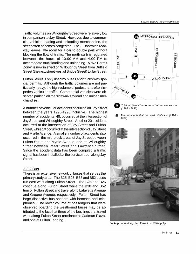
Traffic volumes on Willoughby Street were relatively lowin comparison to Jay Street. However, due to commer-cial vehicles loading and unloading merchandise, thestreet often becomes congested. The 32 foot wide road-way leaves little room for a car to double park withoutblocking the flow of traffic. The north curb is regulatedbetween the hours of 10:00 AM and 4:00 PM toaccomodate truck loading and unloading. A “No PermitZone” is now in effect on Willoughby Street from DuffieldStreet (the next street west of Bridge Street) to Jay Street.
Fulton Street is only used by buses and trucks with spe-cial permits. Although the traffic volumes are not par-ticularly heavy, the high volume of pedestrians often im-pedes vehicular traffic. Commercial vehicles were ob-served parking on the sidewalks to load and unload mer-chandise.
A number of vehicular accidents occurred on Jay Streetbetween the years 1996-1998 inclusive. The highestnumber of accidents, 48, occurred at the intersection ofJay Street and Willoughby Street. Another 20 accidentsoccurred at the intersection of Jay Street and FultonStreet, while 19 occurred at the intersection of Jay Streetand Myrtle Avenue. A smaller number of accidents alsooccurred in the mid-block areas of Jay Street betweenFulton Street and Myrtle Avenue, and on WilloughbyStreet between Pearl Street and Lawrence Street.Since the accident data has been compiled a trafficsignal has been installed at the service road, along JayStreet.
3.3.2 BusThere is an extensive network of buses that serves theprimary study area. The B25, B26, B38 and B52 busesrun east-west along Fulton Street. The B25 and B26continue along Fulton Street while the B38 and B52turn off Fulton Street and travel along Lafayette Avenueand Greene Avenue, respectively. Fulton Street haslarge distinctive bus shelters with benches and tele-phones. The lower volume of passengers that wereobserved boarding the westbound buses may be at-tributed to the fact that three of the bus lines that travelwest along Fulton Street terminate at Cadman Plaza,and one at Fulton Landing.
Total accidents that occurred at an intersection(1996 - 1998)
Total accidents that occurred mid-block (1996 -1998)
#
#
10
85
19
45
20
9
METROTECH COMMONS
PE
AR
L S
T
WILLOUGHBY ST
BR
IDG
E S
T
FULTON ST
JAY
ST
LAW
RE
NC
E S
T

12
EXISTING CONDITIONS
JAY STREET
Scaffolding at 370 Jay Street.
The B26, B57, B67, B61, B75 , and B54 buses run north-south along Jay Street. The B61 travels fromRed Hook through Downtown Brooklyn, all the way north to Hunters Point, Queens. The B57 travelsfrom Ridgewood, Queens and terminates just south of the primary study area, on Boreum Place andSchermerhorn Street. The B65 terminates on Smith Street between Livingston Street and Fulton Mall.From there it turns left on to Fulton Mall for one block, and then turns southbound on to Bergen Streetwhere it continues on to Crown Heights. The B26 only travels along Jay Street in the southbounddirection and turns onto Fulton Street. The B67 and B75 terminate a few blocks north of the primarystudy area and serve Windsor Terrace and Kensington. The B54 runs along Myrtle Avenue and turnsonto Jay Street from the service road that is locatedjust south of Metrotech.
On the east side of Jay Street there are numeroussigns for bus stops, but with different busses stop-ping at different locations. Not all busses stop at alllocations. South of Fulton Street, signage exists forthe B65 and B51 buses, although the B61, B57 andB75 also pass through this section of Jay Street.Farther north on the east side of Jay Street, betweenFulton Street and Willoughby Street, signage indi-cates that the B57 and B61 utilize the bus stop. Thewidened segment of Jay Street in front of MetrotechPlaza contains a bus stop and two signs. One ofthe signs indicates a list of the buses which stopthere. On the west side of Jay Street, signage indi-cates the B26, B61, B67, and B75 buses. Althoughmany more southbound buses pass the bus stop.
3.3.3 PedestrianA network of pedestrian streets and plazas existwithin the primary study area, including Myrtle Prom-enade, segments of Lawrence and Bridge Streets,and the pedestrian path which runs between Jay andAdams Street, to the west of Metrotech Center. Quitea few pedestrians were observed to be jay walkingacross Jay Street between this path and MyrtlePromenade.
Fulton Street was observed to have the highest pe-destrian volumes in the primary study area. In theimmediate vicinity of the Jay Street-Borough Hall sta-tion, Fulton Street is primarily a pedestrian mall. Ve-hicular traffic, with the exception of buses and some trucks, is not permitted between Flatbush AvenueExtension and Adams Street. Wide sidewalks and numerous amenities such as distinctive bus shel-ters with benches and phone booths make this a pleasant area for pedestrians and shoppers.
Several buses stop along Jay Street.
13
SUBWAY-SIDEWALK INTERFACE PROJECT
JAY STREET
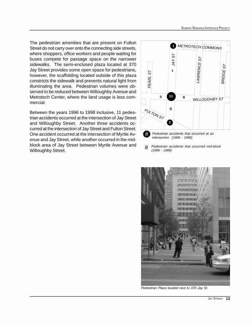
The pedestrian amenities that are present on FultonStreet do not carry over onto the connecting side streets,where shoppers, office workers and people waiting forbuses compete for passage space on the narrowersidewalks. The semi-enclosed plaza located at 370Jay Street provides some open space for pedestrians,however, the scaffolding located outside of this plazaconstricts the sidewalk and prevents natural light fromilluminating the area. Pedestrian volumes were ob-served to be reduced between Willoughby Avenue andMetrotech Center, where the land usage is less com-mercial.
Between the years 1996 to 1998 inclusive, 11 pedes-trian accidents occurred at the intersection of Jay Streetand Willoughby Street. Another three accidents oc-curred at the intersection of Jay Street and Fulton Street.One accident occurred at the intersection of Myrtle Av-enue and Jay Street, while another occurred in the mid-block area of Jay Street between Myrtle Avenue andWilloughby Street.
Pedestrian Plaza located next to 370 Jay St.
Pedestrian accidents that occurred at anintersection (1996 - 1998)
Pedestrian accidents that occurred mid-block(1996 - 1998)#
#
1
0 011
0
1
3
METROTECH COMMONS
LAW
RE
NC
E S
T
JAY
ST
BR
IDG
E S
T
PE
AR
L S
T
FULTON ST
WILLOUGHBY ST

14
EXISTING CONDITIONS
JAY STREET

15
SUBWAY-SIDEWALK INTERFACE PROJECT
JAY STREET
JAY STREET APPENDICES
APPENDIX 1: 1990 CENSUS DATA
Population Data by Age and Census Tract
APPENDIX 2: 1990 CENSUS DATA
Journey to Work - Workers by place of residence
Reverse Journey to Work - Workers by place of employment
APPENDIX 3: 1996-1998 ACCIDENT DATA
Accidents by Node/s
APPENDIX 4: SIGNAL TIMING DATA
APPENDIX 5: INVENTORY OF EXISTING CONDITIONS

16
EXISTING CONDITIONS
JAY STREET
Population data by age
APPENDIX 1: 1990 CENSUS DATA
Source: US Bureau of Census, 1990, STF 3
27
37
43
9
11
2513
5
Jay St-Borough Hall
85+ yrs80-84 yrs75-79 yrs70-74 yrs65-69 yrs22-64 yrs17-21 yrs12-16 yrs6-11 yrs0-5 yrsTotalTract
157212132201174452611612411823559955
723357839137657286211818239
9000135100007311
1223353587128556343362166213
56323124682152173157243150525
1690061390472203257727
701431041151381825226168318190329731
008072172770527137
425286249220928773102120295943
28044137452259212561968629790100518162People
1.5%2.4%2.1%2.9%3.3%69.2%5.3%3.5%4.3%5.5%100%Percent

17
SUBWAY-SIDEWALK INTERFACE PROJECT
JAY STREET
APPENDIX 2: 1990 CENSUS DATA
Journey to Work - Workers by place of residence
Reverse Journey to Work - Workers by place of employment
Source: US Bureau of Census, 1990, STF 3
PercentTotal043037031027025013011009005Census Tract
27.6%2484981337193831037436317262188086985Car, Truck, or Van
9.7%871626412541714327283319873258445Carpool
13.9%125403191837143608143164531524258435Bus or Trolley
0.3%264670182303239760Streetcar, Trolley
38.3%3453869755883721382277409010460106631009Subway or Elevated
4.5%40149164929189503971382116760Railroad
0.2%2190276000106800Ferry
0.5%4649600505313518517Taxi
0.1%9803200017201910Motorcycle
0.5%4224790006310414824Bike
3.4%308420427615182802574611111462Walk
0.6%5410970282165932289Other
0.5%419670290642070205Work at Home
PercentTotal043037031027025013011009005Census Tract
10.5%10091871510977261340103358Car, Truck, or Van
3.0%287580140753040115Carpool
3.6%3485305761587302719Bus or Trolley
0.3%320050000270Streetcar, Trolley
57.5%55056371286936897613128762381Subway or Elevated
0.6%5400108060030Railroad
0.1%100000000010Ferry
1.7%1670037001200118Taxi
0.1%8000080000Motorcycle
0.3%29900039080Bike
17.4%1660200039269712090146573Walk
0.4%3801200060020Other
4.4%419670290642070205Work at Home

18
EXISTING CONDITIONS
JAY STREET
APPENDIX 3:
1996-1998
Accident Data
Accidents by node/s
PedestriansInjuriesFatalitiesReportableAccidentsYearNode/s
12029199624454
01014199724454
22027199824454
3505203 yr total24454
45059199624453
560723199724453
240513199824453
1115017453 yr total24453
00003199624449 24453
00003199724449 24453
00002199824449 24453
000083 yr total24449 24453
00003199624453 24455
00002199724453 24455
00000199824453 24455
000053 yr total24453 24455
01015199624452 24453
11012199724452 24453
02023199824452 24453
1404103 yr total24452 24453
01015199624453 24454
02024199724453 24454
00000199824453 24454
030393 yr total24453 24454
00006199624452
11015199724452
01028199824452
1203193 yr total24452

19
SUBWAY-SIDEWALK INTERFACE PROJECT
JAY STREET
Source: New York State DOT Local Accident Surveillance Project
IntersectionFULTON ST AND JAY ST AND SMITH ST
FULTON ST AND JAY ST AND SMITH ST
FULTON ST AND JAY ST AND SMITH ST
FULTON ST AND JAY ST AND SMITH ST
JAY ST AND WILLOUGHBY ST
JAY ST AND WILLOUGHBY ST
JAY ST AND WILLOUGHBY ST
JAY ST AND WILLOUGHBY ST
WILLOUGHBY ST BETWEEN JAY ST AND LAWRENCE ST
WILLOUGHBY ST BETWEEN JAY ST AND LAWRENCE ST
WILLOUGHBY ST BETWEEN JAY ST AND LAWRENCE ST
WILLOUGHBY ST BETWEEN JAY ST AND LAWRENCE ST
WILLOUGHBY ST BETWEEN JAY ST AND PEARL ST
WILLOUGHBY ST BETWEEN JAY ST AND PEARL ST
WILLOUGHBY ST BETWEEN JAY ST AND PEARL ST
WILLOUGHBY ST BETWEEN JAY ST AND PEARL ST
JAY ST BETWEEN WILLOUGHBY ST AND MYRTLE AVE
JAY ST BETWEEN WILLOUGHBY ST AND MYRTLE AVE
JAY ST BETWEEN WILLOUGHBY ST AND MYRTLE AVE
JAY ST BETWEEN WILLOUGHBY ST AND MYRTLE AVE
JAY ST BETWEEN WILLOUGHBY ST AND FULTON ST
JAY ST BETWEEN WILLOUGHBY ST AND FULTON ST
JAY ST BETWEEN WILLOUGHBY ST AND FULTON ST
JAY ST BETWEEN WILLOUGHBY ST AND FULTON ST
JAY ST AND MYRTLE AVE
JAY ST AND MYRTLE AVE
JAY ST AND MYRTLE AVE
JAY ST AND MYRTLE AVE

20
EXISTING CONDITIONS
JAY STREET
APPENDIX 4: SIGNAL TIMING DATA
TIMEFLOWTRAFFIC
CROSSWALK ORIENTATIONINDICATORINTERSECTION
All dayFulton St.Crossing Jay St along north side of Fulton StA
All dayFulton St.Crossing Smith St along south side of Fulton StB
All dayJay St.Crossing Fulton St along west side of Jay StC
All dayJay St.Crossing Fulton St along east side of Jay StD
Fulton and Jay Street
TIMEFLOWTRAFFIC
CROSSWALK ORIENTATIONINDICATORINTERSECTION
All dayJay St.Crossing Willoughby St along west side of Jay StE
All dayJay St.Crossing Willoughby St along east side of Jay StF
All dayWilloughby St.Crossing Jay St along north side of Willoughby StG
All dayWilloughby St.Crossing Jay St along south side of Willoughby StH
Jay Street and Willoughby Street
G
H
FE
CA
DB
WILLOUGHBY ST
LAW
RE
NC
E S
T
MIT
H S
T FULTON ST
PL
AD
AM
S S
T
RED HOOK LA
JAY
ST
PE
AR
L S
T
LIV
Intersection Map: Jay Street

21
SUBWAY-SIDEWALK INTERFACE PROJECT
JAY STREET
Jay Street and Willoughby Street
Fulton and Jay Street
J
I
K
G
H
FE
JAY
ST
LAW
RE
NC
E S
T
WILLOUGHBY ST
PE
AR
L S
T
BR
IDG
E S
T
MYRTLE AV
Intersection Map: Jay Street
TimeCrossingSufficient
ofEstimationPreliminary
Street*to CrossRequired
TimeEstimated
Only)(GreenTime
CrossingPedestrianAdjusted
and Amber)Time (Green
CrossingPedestrian
Total
WidthCrosswalk
LengthCrosswalk
TIMECYCLE
REDAMBERGREEN
secondssecondssecondsfeetfeetsecondssecondssecondsseconds
Sufficient1330332552902330
Sufficient1330332552902330
Sufficient5.7550532023902350
Sufficient5.7550531823902350
TimeCrossingSufficient
ofEstimationPreliminary
Street*to CrossRequired
TimeEstimated
Only)(GreenTime
CrossingPedestrianAdjusted
and Amber)Time (Green
CrossingPedestrian
Total
WidthCrosswalk
LengthCrosswalk
TIMECYCLE
REDAMBERGREEN
secondssecondssecondsfeetfeetsecondssecondssecondsseconds
Sufficient849521232902349
Sufficient849521232902349
Sufficient13.25313411.553902331
Sufficient13.2531341153902331

22
EXISTING CONDITIONS
JAY STREET
TIMEFLOWTRAFFIC
CROSSWALK ORIENTATIONINDICATORINTERSECTION
All dayJay St.Crossing Myrtle St along east side of Jay StIAll dayWilloughby St.Crossing Jay St along north side of Willoughby StJAll dayWilloughby St.Crossing Jay St along south side of Willoughby StK
Jay Street and Myrtle Avenue*
* Outside of study area, informational purposes only.

23
SUBWAY-SIDEWALK INTERFACE PROJECT
JAY STREET
Source: NYC DOT
Jay Street and Myrtle Avenue
* Outside of study area, informational purposes only.
TimeCrossingSufficient
ofEstimationPreliminary
Street*to CrossRequired
TimeEstimated
Only)(GreenTime
CrossingPedestrianAdjusted
and Amber)Time (Green
CrossingPedestrian
Total
WidthCrosswalk
LengthCrosswalk
TIMECYCLE
REDAMBERGREEN
secondssecondssecondsfeetfeetsecondssecondssecondsseconds
**4952**902349
**3134**902331
**3134**902331


Recommended