GEOLOGIC MAPPING 101: COMMON PITFALLS AND SUGGESTIONS
FOR A MORE EFFICIENT APPROACH
Mark Zellman1 & Kristi Zellman2
1Fugro Consultants, Inc. 2Colorado School of Mines and U.S. Geological Survey

INTRODUCTION

COMMON TASKS
• Converting raster maps to vectors
• Scanned paper maps
• Digital raster images
• Cleaning up vector messes
• Symbolizing
• Attributing
• Metadata
• Publishing Raster Source
Vector Lines
Polygons

COMMON PROBLEMS: RASTER MAPS
• Missing spatial reference control
• Inaccurate spatial control
• No listed spatial reference information
• Obscure projections
• Shifted data
• Mapping errors
• Poor print quality
• Scanning of rare and brittle historic
maps
• Deep creases = warped scans
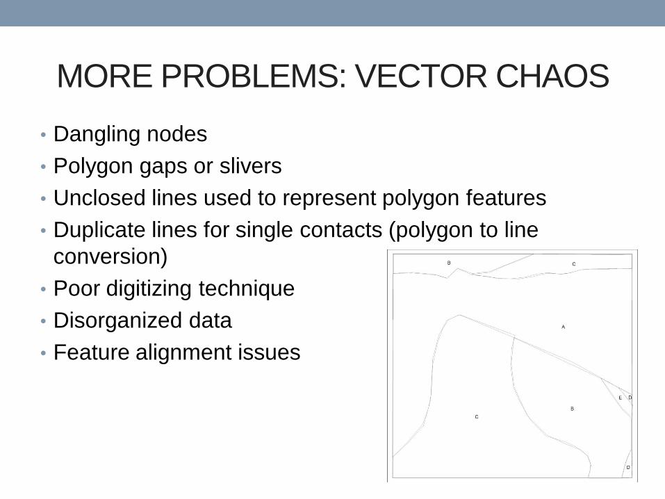
MORE PROBLEMS: VECTOR CHAOS
• Dangling nodes
• Polygon gaps or slivers
• Unclosed lines used to represent polygon features
• Duplicate lines for single contacts (polygon to line
conversion)
• Poor digitizing technique
• Disorganized data
• Feature alignment issues

MAP EXAMPLE

MAP EXAMPLE

MAP EXAMPLE
Unit overruns
fault contact
Gaps
Overshoot
Overshoot Map features
extend beyond
boundary
Gaps

UNCLOSED POLYLINES

MANAGING THE PROBLEMS
• Raster Issues
• Projections:
• Research (ASPRS is a good resource)
• Comparisons with satellite imagery, orthophotos, topographic maps
• Trial and error
• Warped Scans
• Georeferencing tools:
• 1st – 3rd order polynomial
• Stretch
• Vector Issues
• Data QA/QC
• Topology tools help!
• Educate misguided GIS users who pass their problems to you.

HOW TO AVOID THESE PITFALLS
• Learn how to use GIS tools effectively
• Don’t create GIS data in a graphics software package
• Understand your subject-matter to depict appropriately
• Use a standardized method for managing vector data
from the start…

STEP 1: HAVE A PLAN
• Know your:
• Projection
• Map scale
• Map units
• Establish a naming convention
• Organize the attribute table
• Consider the data format (shapefile or geodatabase)
• Not everybody can view your ArcGIS version 10 geodatabase files
• Vector structure (faults, contacts, folds, dikes, etc..)
• Plan the editing and revision process
• What about software??

STEP 1.1: SOFTWARE
• You’ve got options…
1. ArcGIS Desktop + Extensions
• Digitize shapefiles and convert to polygons with extensions (ET
Geowizards)
2. ArcINFO
• Create as shapefiles or geodatabase files and convert to polygons
• Create geodatabase files and establish topology then convert to
polygons

STEP 2: ORGANIZE YOUR DATA
• Develop an organized file structure
• Use a descriptive and progressive file naming convention

STEP 3: THE DIGITIZING WORKFLOW
• Digitize the units as LINES, not polygons
• If you were to draw units, how would you do it?
• Use the editing templates in ArcGIS version 10
• Digitize the map boundary and faults before contacts
• Keep cultural features, folds, hydrology separate – refer back to
your plan.
• Use snapping
• Save often!!!!
Points
Separates
Geologic Lines
Geologic Polygons

• ArcGIS + ET GEOWIZARDS
STEP 4.1: LINES TO POLYGONS
Build Polygon
Tool
Shapefile
Lines v1
ET
Geowizards Polygon v1

• ArcINFO
STEP 4.2: LINES TO POLYGONS
Feature to
Polygon
Shapefile
Lines v1 ArcToolbox Polygon v1
Construct
Polygons Topology Rules
Geodatabase
Lines v1 Editor
Toolbar
GDB
Polygon v1

STEP 5.1: THE EDITING PROCESS
• Maintain data organization and file naming conventions
• Develop an organized process for creating, editing and
updating files
• Edited polygons require updated attributes (preserve
attributes)

STEP 5.2: THE EDITING PROCESS
Polygon v1
Topology Edits
Editor Toolbar Polygon v2
Feature to Point • Preserve Attributes
• Choose Inside
Option
ArcToolbox
Points v1
Line v2
Line to Feature • Import attributes
from Points v1
ArcToolbox
Polygon v2
Edits
Lines v1
Option 1
Option 2

STEP 6: SYMBOLOGY AND ATTRIBUTES
• Use standard colors for unit polygons and standard
symbols for geologic features (ESRI, USGS)
• FGDC Digital Cartographic Standard for Geologic Map
Symbolization (FGDC, 2006)
• ESRI Geologic Map Template
• ESRI symbol template pallet
• Important traits for attributes
• Consistency
• Limitation
• Descriptive
• Easy for a user to interpret

STEP 7: METADATA
• Take time to write thorough metadata
• Know what format your users are using
• Use a metadata editor
• ArcCatalog
• EPA Metadata Editor

CONCLUSION
• These approaches can be applied to projects in other
disciplines
• To avoid common mapping pitfalls:
• Take the time to make a plan before you start a GIS project
• Understand your subject matter and audience
• Always take the time to write thorough metadata
• A standard and organized approach is necessary

REFERENCES Federal Geographic Data Committee [prepared for the Federal Geographic Data Committee by the U.S. Geological
Survey], 2006, FGDC Digital Cartographic Standard for Geologic Map Symbolization: Reston, Va., Federal Geographic Data
Committee Document Number FGDC-STD-013-2006, 290 p., 2 plates.
EPA Metadata Editor (EME), version 3.1.2, 2012; https://edg.epa.gov/EME/Home.htm

Thank You!
Questions?
Recommended