People’s perception in Early Warning System: A case study of Bhandara VDC Padariya -7 in Chitwan district, Nepal
A Dissertation for the Degree of Master in Disaster Management
By
Richa Lamichhane
Student ID: 10268O10
Fall 2011
Postgraduate Programs in Disaster Management (PPDM)
BRAC University, Dhaka, Bangladesh
i
Acknowledgement
Above all, I would like to thank my God for his untold and all time grace that gave
me enthusiasm to start and finish my dissertation and my family for all their support
especially Dad, Mum, Brother, Grandmother, maternal uncle and Aunts and my cousins.
I would also like to express my deepest gratitude to my advisor Professor Md. Rezaur
Rahman for his supervision and constructive comments throughout the preparation of this
thesis. I would also like to PPDM programme coordinator M Aminur Rahman for his
relentless support and pushing up to complete the dissertation was not possible.
I extend my inner thanks to Lok Raj Silwal and Anup Phaiju (Practical Action) who has
helped me by providing different resources on early warning which was really useful in
completing this study and his time to time feedback since the beginning of the work till the
completion of this Master’s thesis is accredited highly.
I would also extend my inner thanks to officials from VDC and local NGO for their
concerted effort to make my field work possible.
I would also like to thank my PPDM colleagues, apartment mates and others for making my
overall stay in Bangladesh sweet and memorable, may god bless you all.
Lastly my deepest gratitude goes to community at Padariya VDC ward 7 for their support and
time without them it would hadn’t been possible.
Table of Contents Acknowledgement i Abstract ii Table of Contents iii List of Figures iv List of Photographs v List of Abbreviations vi Chapter I INTRODUCTION 1-7
1.1 General 1 1.2 Background 2-3 1.3 Statement of the problem 3-4 1.4 Justification of the research 4-5 1.5 Organization of the report 5-6 1.6 Overall objectives of the study 6 1.7 Specific objectives 6 1.8 Limitations of the study 7
Chapter II REVIEW of LITERATURE 8-18
2.1 Flood scenario in Nepal 8-9 2.2 Early warning 9-10 2.3 Early warning in Nepal 10-12 2.4 Case studies from different countries 12-14 2.5 Government plans and policies regarding disaster management in Nepal 14-18 2.5.1 Natural calamity relief act 15-16 2.5.2 Local self governance act 16 2.5.3 The Tenth plan 16-17 2.5.4 Medium term expenditure framework 17 2.5.5 Hyogo framework of action and EWS 17-18 2.6 Research question 18 Chapter III Study Area 19-21 3.1 Study area and national context 19-21 Chapter IV Materials and Method 22 4.1 Conceptualization and research question identification 22 4.2 proposal preparation, presentation and integration of comments 22 4.3 Methods 22-26 4.3.1 Review of relevant literature and information 23 4.3.2 Source of data 23 4.3.3 Data collection tools 24-25 4.3.4 Data collection procedures 25 4.3.5 Data analysis procedures 25 4.3.6 Sample size 25-26
Chapter V Results 27-38 5.1 Introduction 27 5.2 Socio economic description of Padariya 27
5.2.1 Human assets in Padariya 28 5.2.2 Social assets 28 5.2.3 Natural asset 28 5.2.4 Physical asset 28 5.2.5 Financial asset 29
5.3 Resource Mapping 29-30 5.4 Focus group discussion 30 5.5 Key informant interview 30-31 5.6 Time line analysis 31-32 5.7 People Perception on EWS and response 32-35 5.8 Traditional Flood Knowledge 35-36 5.9 Drawbacks on the early warning facility at Padariya 37-38 5.9.1 Layout of the structure 37 5.9.2 Sustainability of the tower 37-38 Chapter VI Conclusion and Recommendations 39-42 References
ii
Abstract
Flood impact and vulnerability towards the poor people has always been significant aspect of issue
and discussion worldwide. With the current climate change scenario and various studies in the past
related to climate change has shown that flood frequency has increased leaving people in the flood
plains more vulnerable. People in the river bank due to lack of EWS and also due to the inefficiency
of the prevailing system they are more prone to stresses and burden in their lives due to floods.
The main objective of the paper was to understand the perception of the particular community
towards the prevailing Early Warning System (EWS) their response mechanism during the flood at
Padariya-7 of Bhandara VDC in Chitwan district of Nepal.. For this research participatory tools for
assessing the perception and response mechanism, various tools like, Resource Mapping, Timeline
Analysis, Focus Group Discussion were used and Key Informant Interview(KII) was used for the
validating the findings. To assess the information literature were reviewed from different journal
article, published books, government policies, and other unpublished thesis work and articles.
EWS is a very important aspect of Disaster Risk Reduction (DRR). For the people in the community
since the establishment of the system it has proved not of any significance. People were hostile
towards the project as it was giving false sense of hope towards the people. No proper warning
dissemination techniques were found during the study. Moreover villagers have no regular drills even
though the project was in the implementation phase. Rather than using the Early Warning facility
people living in the river bank for many decades they were more found to be using the traditional
knowledge for forecasting of the flood. No focus of the NGO was found to be upgrading the EWS
after it was over. Though most of the people go to the embankment to see the level of the river during
the rainy season the problem is more acute for the disabled, old age, ill people and lactating mother
which has less mobility. As the nature of the flood is flash in the area there is less time for people to
respond and they only manage to save their lives and livestock from the past experiences.
Thus the study suggest to address the challenges in the early warning facility for the community with
the help of study at micro level and making plans policies and programme of improvement of the
system with more lead time of forecast and proper dissemination techniques for the sufferer of the
flood in the river basin of Rapti.
List of Pictures
Pic no. Title of the Pic Page
Pic. 1 Early warning tower 11
Pic. 2 River gauge 12
Pic. 3 Padariya VDC at Chitwan District on the basin of Rapti river 20
Pic. 4 Resource Map 29
Pic. 5 Interview with Key Informant 30
Pic. 6 Timeline Analysis 31
Pic. 7 Early warning tower at study area 37
List of Tables
Table no. Title of the Table Page
Table. 1 Community Perception and response for reduction of loss with increased lead time 35
Table. 2 Traditional early warning flood indicators 36
Abbreviations:
CBS Central Bureau of Statistics
CDRC Central Disaster Relief Committee
DAO District Agriculture Office
DDC District Development Committee
DDRC District Disaster Relief Committee
DoHM Department of Hydrology and Meteorology
DRR Disaster Risk Reduction
DWIDP Department of Water Induced Disaster Prevention
EWS Early Warning System
FGD Focus Group Discussion
HFA Hyogo Framework of Action
KII Key Informant Interview
MOA Ministry of Agriculture
MOHA Ministry of Home Affairs
NGO Non Government Organization
NSDRM National Strategy for Disaster Risk Management
UNDP United Nations Development Programme
UNEP United Nations Framework Environment Programme
UNISDR United Nations International Strategy for Disaster Reduction
UNOCHA United Nations Office for Coordination of Humanitarian Affairs
VDC Village Development Committee
VHF Very High Frequency
WECS Water and Energy Commission and Secretariat
1
Chapter I
Introduction
1.1 General
Climate change and human activities are playing influential factor for disasters. Global warming is an
important cause of serious natural disaster (Such as typhoon, sea level rise, droughts and floods etc.
the disaster risk is the probability of losses occurring that depends on hazard and vulnerability (UNU-
ITC DGIM, 2009). The hazard factors are occurred by natural phenomenon and also socio natural
hazards. Concurrently, the vulnerability refers to political institution, economic and socio cultural
and environmental factors (GTZ, 2002). Referring to the framework of disaster risk management
(DRM) elements, the disaster risk reduction (DRR) or minimizing the vulnerability is possible by
prevention or limiting (mitigation and preparedness) the effects of hazard (UNU ITC, DGIM, 2009).
This also depends on the coping capacity of the people or communities living in disaster prone areas.
Currently the numbers of vulnerable groups in disaster areas are increasing due to population growth,
improper land use planning, environmental degradation .And they are in the high risk of disaster as
less investment is done for the early warning system for the communities living in the bank of river.
In order to minimize the damage on lives and livelihood early warning is most important. But
sometimes people have received warning after the vent has occurred, these event tend to lose the
confidence of the people regarding the EWS as poorly targeted system fails to reach to those who
were at risk.
Early warning is a key component to take appropriate measures with proper institutional
arrangements in the disaster prone areas. Early warning system plays a vital role in disaster prone
areas in pre disaster phase of Disaster risk management cycle. In other word EWS doesn’t only
support the independent operation but also the participation of the local people and key actors as a
part of preparedness activities to with stand the disaster impact. Therefore research aims to
seek the perception of the people regarding the warning message, dissemination
techniques, and their actions on the response to warning message.
2
1.2 Background:
Globally, Nepal is perhaps unique in the diversity of its topography and geography. Nepal is a small
landlocked country situated in the central part of the Himalayan Range with an area of 147,181sq
km. Nepal's landscape is incredibly diverse with lots of flora fauna within the 3 ecological regions
namely Mountain, Hill and Terai which range from flat pains to 8000m high mountains (WECS,
2002). For many synonymous with the high peaks of the Himalayas just under 50% of its population
actually live in the flat plains of the Terai, a region running from one end of the country to the other
parallel to the Indian border (CBS, 2006). Though occupying only 17% of the country’s land mass
the Terai is responsible for the bulk of the country's agricultural output, supports the main
communication and transportation arteries, and carries its major system. Watered by three major river
systems, the Koshi, Narayani and Karnali, the population of the Terai are exposed to floods annually,
the impacts of which have grown in severity and regularity in recent years. The reasons for this are
many, with climate change often cited as the most critical, but in truth the area has experienced
massive population growth and intensification of agriculture over the last 50 years, to the extent that
cause and effect are vague.
At the present time the damaged caused by unexpected hydro metrological disasters has increased
worldwide with assorted like East Asia Tsunami in 2004 that took lives of 2,30,000 people, hurricane
Katrina in North America in 2005 accounted more than $75 million worth of economic damage (FIG
2006). Lately the flood event in Pakistan 14 million people were affected (BBC, 2010). This disaster
event doesn’t destroy only lives and resources but also reduce liquidity of economic resource and
social development. (GTZ, 2002)
The climate change caused by human interventions also increasing the disaster frequency (GTZ,
2002). Every year 2, 50,000 people are killed by disaster all round the world out of which 95% lives
in developing countries (UN-HABITAT, 2008). As a developing country, Nepal suffers from severe
disasters as it has unique landscape and climate change.
Specifically various factors like: rugged and fragile geophysical structure, very high relief, high angle
of slopes, complex geology, variable climatic conditions, active tectonic processes, unplanned
settlement, dense and increasing population, poor economic condition and low literacy rate have
made Nepal vulnerable to natural disasters (Chettri, 1998).
3
The major sources of water in the river are the glacier in the great Himalayas and the snow fed rivers
are the main cause of flooding each year, which is intensified by the climate change scenario. For
hundreds and often thousands of people each year monsoon related floods result in massive loss of
property, erosion of land, loss of irreplaceable assets, and loss of livestock’s e.t.c.(Ibid). These facts
emerges that Early Warning system in the country should be the priority to minimize the loss and
damage rather than spending for post flood response and recovery.
In the management of flood in Nepal, development agencies have taken many structural and non
structural majors. One of the main non structural measures for flood preparedness is flood forecasting
and early warning. NSET (2008) identifies the need of early warning for flood hazards which is one
of the priority actions in the Hyogo framework of action which suggest identifying, assessing and
monitoring disaster risks and enhancing early warning in the disaster prone areas.
Many of the development organizations through different seminars, workshop and their publications
are trying to show the Early Warning System(EWS) is a great success but every year of the flood is
damaging infrastructure, taking away live of live stock and people. These consequences shows that
the main hurdle is the perception of the flood affected people regarding the early warning system/
message and their preparatory actions based on the early warning message.
At present few EWS has been setup in Nepal in the Eastern, western and central region in the flood
prone areas as community based early warning system by different International organization
namely, mercy corps, practical action (Practical action, 2009).
1.3 Statement of the problem:
Three quarter of the total land area of Nepal is hilly and many villages are situated on or adjacent to
the unstable hill slopes. As a result, the landslide and flood with debris flow occurs. Unplanned
settlements and physical constructions without due consideration to the natural hazards are
considerably aggravating the mountain environment. On the other hand the landslide add enormous
load to the streams and rivers causing flood and debris flow downstream. Each year such types of
disasters cause the losses of a number of human life and immense damages to agricultural land,
crops, human settlements and other physical property.
4
Though it is unfortunate that early warning system is not yet developed in Nepal except for
weather forecasting. Early warning has been one of the main agendas in the Hyogo framework of
action to reduce the disaster loss in terms of lives and property damage. By mainstreaming major
international framework and protocols very few NGO’s in Nepal has been working for promoting the
early warning system in Nepal. In Nepal there is no adequate forecasting and warning system for the
floods and other hazards. It is mainly due to the lack of technical manpower and adequate resources.
Combining the above features with the unyielding geographical feature of Nepal, the set of
challenges faced here with respect to disaster management are complex and difficult to overcome (
Chettri, 2010).
Planning and implementation has been a good achievement for the NGO’s in the field of early
warning for building the resilience of the vulnerable communities. Further many of the NGOs report
have depicted the pictures that early warning system has been success regarding the sustainability
and response of the people before the hazard.
Though the successful early warning system are facing hindrances like community perception, lack
of knowledge on responding to flood and prepare for it, lack of co-ordination between the
stakeholders and lack of community interest are emerging.
With the above mentioned hindrances it always a question on people’s perception regarding the
message in forecasting and warning, and people response on the basis of warning, and issues
regarding the sustainability which need to be addressed by the NGO’s and concerned stakeholders
for the success of EWS to increase the resilience of the people.
1.4 Justification of the Study:
Enemark 2010 stated that “by combining disaster risk information with people perception and other
relevant information of land use, people understanding about the hazards and responses during and
aftermath of disaster is crucial. Therefore information regarding the perception community responses
in needed in the emergency and pre disaster phase.
Fakruddin (2011) describes that lack of people understanding on forecasting and warning message
though the installation of the EWS increases the vulnerability and risk among the potential
beneficiaries of EWS.
UNEP(2010) reports that floods are the deadliest natural hazards that are currently increasing in
frequency, the study shows inadequate coverage of flood warning and monitoring systems, especially
5
in developing or least developed countries such as China, India, Bangladesh, Nepal, West Africa, and
Brazil. In addition, at a global scale flood monitoring systems are more developed than flood early
warning systems that have received less attention. For this reason, existing technologies for flood
monitoring must be improved aiming at increasing prediction capabilities and flood warning lead
times and community involvement is most.
In the case study area in chitwan district, sixteen hazards occur with flooding being the most severe
(DDC, 2004). Over Rs 10.62 billion has been loosed in last 49 years. The disaster vulnerability of the
district contributes landslides because of flooding. The consequence is the debris from hill of
Chitwan and Makwanpur to Rapti River. During last couple of years almost 1000 people were killed
in landslides and flooding. The dam developed by Asian Development Bank (ADB), East Rapti
Project (ERP) protects floods in agricultural areas, but with the increase in water level significantly
the dam could not prevent flooding in the near future. Accordingly the study on the perception of
people regarding the early warning system and their responses is necessary to reduce the loss of lives
and properties because of flooding.
These examples demonstrate that necessity of understanding peoples people insight on the existing
early warning system at study area, sustainability of the system are associated bundle of issues to
reduce the vulnerability of poor and marginalized people and communities. There for early warning
system in the disaster prone areas are relevant and important to be studied.
1.5 Organization of the report
The first chapter deals with the general information of the study relating to global impact of disasters
its risk to the vulnerable population. Global warming around the world is explained along with its
linkages to different sectors like change in temperature and precipitation, disastrous events, rise in
sea level etc. a precise summary is presented in the introductory part about different phases in
disaster risk management framework. Further, introductory chapter deals with sufficient background
information to allow the dissertation readers to understand the problems, contexts and significance.
Second part of the introductory chapter explains being more specific and concise about the problem,
importance of research topic in the national level as well as global level to know about the early
warning system. Problem is stated for readers and other who uses the research findings to give a clear
concept on why research was being done though these are further discussed.
6
Chapter II deals with the literature reviews from different articles, books, and journals available in
the internet, libraries, other published dissertation and unpublished works. Chapter III deals with the
justification of the study on the Early warning system. Based on the literature review the particular
topic of the dissertation is justified. First part of chapter IV deals with one overall objective and
three specific objectives of the study. This throws light on methodology as well as expected
outcomes of the accomplished work. Secondly, the extent of the work is covered. There is detail
description of the study area mainly chitwan district livelihood of the people, hazards to them in the
area and flood event faced by them in the Padariya VDC is also presented. Despite the coverage as
explained in the scope, there were other limitations in methodology, time, data, field visits which is
explained in the limitations. Materials and methods in order to gather information and present them
for useful purpose at an understandable level are explained in detail in Chapter V. There is a detail
description of the planning of the work. All materials and methods applied are explained in details
with information on sampling types of data used for analysis and presentation. A description is
provided on detail of field methods and each method is also clearly elucidated. Social mapping, Time
line analysis, and Focus group discussion interview their specific techniques are described. Data
collection and analysis procedures are dealt at the end of the chapter.
1.6 Overall objectives of the study:
To assess, people perception in forecasting and warning, their response on the basis of warning and
identify the suggestion to improve the message and dissemination techniques of EWS for the
sustainability of the system.
1.7 Specific Objectives:
To examine the perception of people on flood forecast and warning messages.
To explore the actions taken by community on the basis of warning messages.
To identify suggestion/advice to improve warning message and dissemination techniques and
ensure sustainability of the system.
7
1.8 Limitations of the Study:
It is exploratory in nature and is study of only one community where EWS was installed, from
Rapti river basin in chitwan district due to limited resources, time and financial constraints.
This is a case study research on the EWS of the Padariya -7 of Bhandara VDC on the bank of
Rapti River in Chitwan district, in Nepal. Thus, the finding will show the perception of people on
message of early warning, response mechanism focusing on the particular community. It is held
that the result generated from this study is relevant to many areas of the county as well as other
countries which have similar socioeconomic and livelihood pattern.
8
Chapter II
Review of Literature
2.1 Flood Scenario in Nepal:
There are more than 6000 streams and rivers in Nepal which flow mostly from the north towards the
south generally with high velocity due to high river gradient (Chettri, 1998). Most of the big rivers
are snow fed which originate from the Himalayan ranges that are covered by perpetual snow. As the
topography of the country is steep, rugged and high-angle slope with complex geology, very high
intensity of rainfall during monsoon season causes flood, For hundreds and often thousands of people
each year monsoon related floods result in massive loss of property, erosion of land, loss of
irreplaceable assets, and loss of livestock’s e.t.c.(ibid). According to the UNDP report “Reducing
Disaster Risk: A challenge for development” Nepal ranks 12th in the world in terms of the proportion
of its population exposed (23.74%) to the threat of flood annually.
Flood is the most destructive types of hazard in Nepal. Three quarter of the total land area of Nepal is
hilly and many villages are situated on or adjacent to the unstable hill slopes. As a result, the
landslide and flood with debris flow occurs. Unplanned settlements and physical constructions
without due consideration to the natural hazards are considerably aggravating the mountain
environment. On the other hand the landslide add enormous load to the streams and rivers causing
flood and debris flow downstream. Each year such types of disasters cause the losses of a number of
human life and immense damages to agricultural land, crops, human settlements and other physical
property. In July 1993 A.D. Nepal experienced a devastating flood in the Terai region of Nepal
which took the life of 1336 people and affected 487,534 people .(MOHA, 1998). Flood in 1998 was
severe which affected various parts of the country, mainly the Terai and Middle Hill region. This
disaster claimed 273 human lives, injured 80 people and killed 982 cattle heads. Besides, 33,549
families were affected, 13,990 houses and 1244 cattle sheds were destroyed and 45 thousand hectares
of land and agricultural crops were ruined (MOA, 1998). This disaster of 1998 A.D. caused the total
loss of about NRs 2 billion. Additionally, in 2007 60% of the country was affected by floods and
landslides affecting 70,000 families. In 2008 flooding in the Western Region affected more than
9
180,000 people and in the Eastern Region a separate flood event affected 70,000 people in Nepal and
more than 2.3 million in neighboring Bihar State in India (OCHA,2008)
Annual Precipitation of Nepal is 1630 mm and if the rain fall is more than 300 mm in a day then
many river in the country will lose its balance leading towards serious flooding. In addition, due to
global warming the melting of the snows in Himalayan region is increasing the water levels in the
river. The climate change model in 21st century shows that intense summer monsoon is increasing
the rainfall events. As the impact of climate change melting of the glaciers will cross the peak period
at 150-170% between 2030- 2050 in Nepal (Oxfam International, 2009).
Due to above mentioned a fact flooding is the serious annual phenomenon. The effectiveness in Early
warning system will help to reduce the vulnerability and increase resilience of the community to
withstand and cope with disaster. Lastly message dissemination and community response are the
other associated events to Early warning system is to be considered for the vulnerable community.
2.2 Early Warning:
Early warning has always been considered a cornerstone of disaster reduction. One goal of the
IDNDR was that all countries should, by the year 2000, have ready access to global, regional,
national and local warning systems and broad dissemination of warnings.
Early warning system includes chain of concerns i.e. Understanding & mapping hazard, forecasting
impending events, processing and disseminating understandable warning to political authorities and
the population, to take appropriate and timely actions in response to the warnings (UNISDR, 2007).
Advances in science and technology during the last decade have improved the potential of early
warning to reduce human loss. Early warning systems also must be comprehensible and accessible to
all users. They must deliver clear and concise messages tailored to respective social and cultural
contexts. The ability to deliver vital information to the public at risk has not always been successful.
In many cases, local mechanisms for communicating risk and interpreting warnings remain very
weak.
Sophistication of technical information may be of little use if it is not linked to the local situation’s
capacities, resources and traditions. Moreover, detailed information about the adverse impacts of
hazards on people and infrastructure, and their vulnerability – necessary for informed decision-
10
making – is often missing. Even where procedures do exist, communities often do not respond
appropriately to warnings because of lack of community engagement and lack of planning, training,
resources or viable response options. In many documented cases, the perceived threat of looting
following evacuations is considered greater than property loss caused by disaster. In the absence of
information about what actions to take, warnings can create panic or indifference. (UNISDR, 2009)
As stated by Sorensen (2000), “better local management and decision-making about the warning
process are more critical than promoting more advanced technologies, although both would help”.
2.3 Early Warning in Nepal:
Flood early warning is the advance notices that a flood may occur in a near future in a certain river
basin which usually issued in a time for a people to move to the safer places and safeguard their
properties.
Nepal being small and landlocked country has lots of problem with in it. Nepal suffers from low
levels of electrification, poor telephone connectivity, meager and seasonally disrupted road network,
political upheaval which has only recently moved beyond the stage of open conflict, ethnic, religious
and linguistic division and an only slowly expanding economy. Hand in hand with these problems,
Nepal suffers from different forms of disastrous events like flood, landslide, fire windstorm and
every year many people become homeless and asset less.
According to the UNDP report “Reducing Disaster Risk: A challenge for development” Nepal ranks
12th in the world in terms of the proportion of its population exposed (23.74%) to the threat of flood
annually. As many rivers in the country get it water from the Himalayas and upstream lies with in the
country. Damage done by flood is devastating every year so there is a strong need of proper early
warning system in the country at the upstream to save the population. As Nepal is a developing
country due to lack of resources government is reluctant to have the flood forecasting system in
Nepal. DHM has not enough rain stations and gauge station needed for the forecasting.
Different NGO's working in Nepal has initiated the flood forecasting and warning system in Nepal
with the concern to save the lives of the vulnerable population. Practical action, Oxfam GB and other
11
are initiating the work. The major work in the early warning was carried by Practical action in its
working areas.
Watch tower and the Benchmark in the river (river gauge) and small scale like linking upstream and
downstream linkages and integrating the Early warning committee with these components are the
basics work done till date.
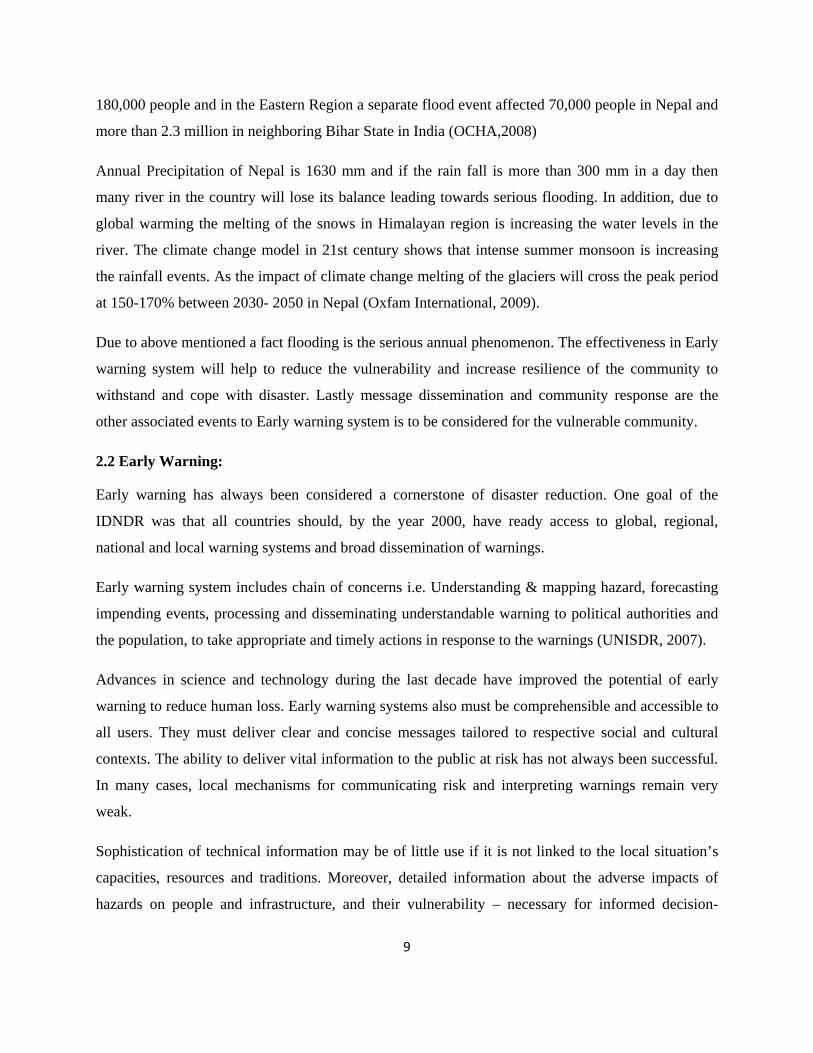
Watch Tower was initiated in the Chitwan district, which lies in the central region of the country and
the projected was initiated in 2002. Construction of the tower and provision of siren systems were
managed by Practical Action while site identification, land purchase, community mobilization,
awareness raising and establishing a user committee were the responsibility of the community.
Watch tower consist of battery for operating the sirens there is the problem of electricity.
Picture 1 : Early warning tower (Adapted from Practical action, 2008 )
The top of the tower consist of cogurrated tin during heavy rain fall there will be the problem in
disseminating warning followed by the range of the siren is limited.
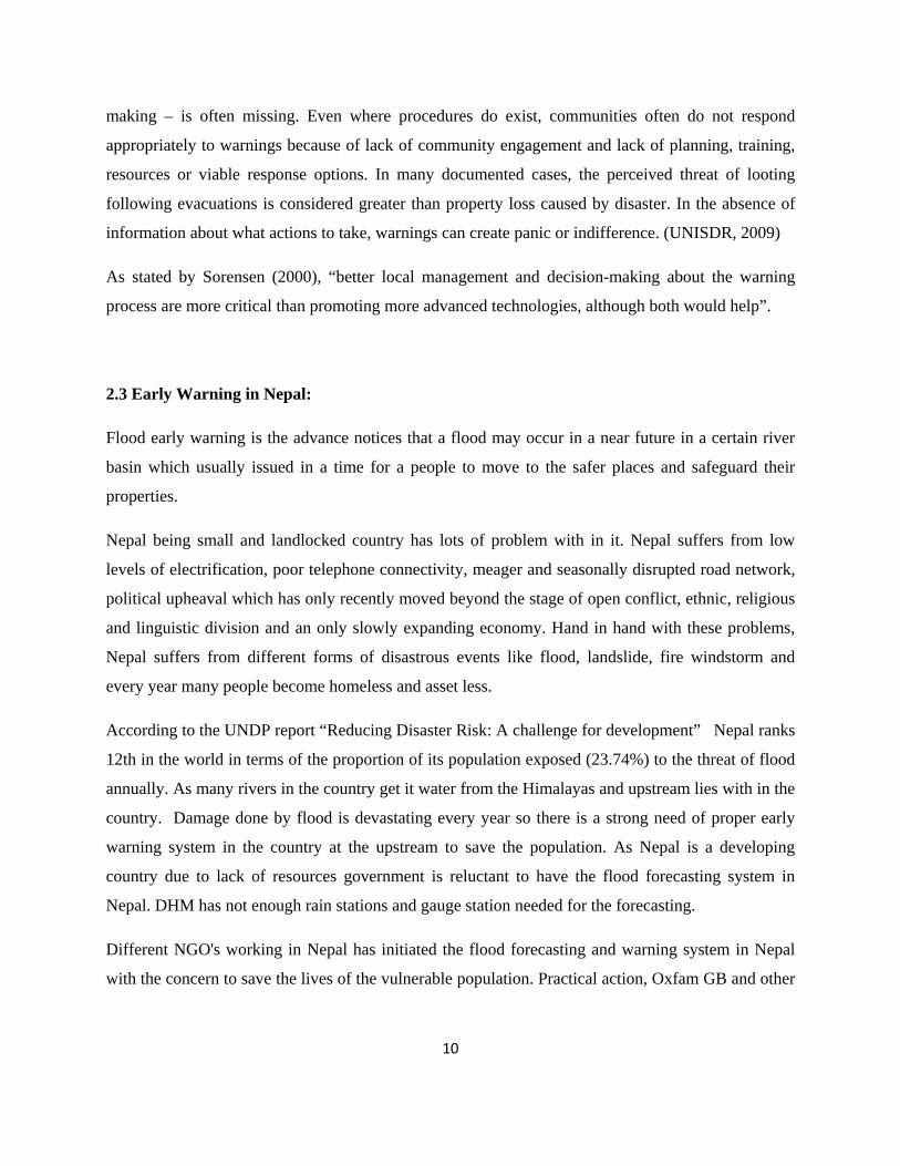
Another initiative for the early warning is the river gauge at the river which was started in early 2007.
Many river of Nepal during the summer is dependent on the rain fall in the upstream with the
objective of passing the information from upstream this project was initiated to prevent the loss from
flood. With the co ordination of DHM data were analysis for last 30 years and flood gauge were
constructed in the bank of river indicating different flood zone. The gauge reader at the gauge station
is responsible for disseminating the information to the early warning committee in case of flood
situation who were dwellers of the downstream through mobile or VHF set. Consecutively the
12
information is disseminated to Police offices, local fm stations and mobilization of early warning
volunteer is done to evacuate the place. The siren is also used to pass the information as 1st siren
gives people to manage their valuables and livestock’s where as second siren is to go towards the
safe place or higher ground.
Pic 2 River gauge (Adapted from Practical action, 2008)
Beside these there are small projects like linking the upstream and downstream communities. Due to
the topography rainfall at upstream have possibilities of flood in the downstream. So telephone
communication between two communities is also helping to forecast the flood. Rain fall at the
upstream mobilize the focal person to use the tele - communication to call the focal person of early
warning committee in the downstream. And the early warning volunteers at the community with
hand mike and local instrument starts to disseminate the information to the vulnerable people.
Still in the community with wide coverage has the problem of information dissemination and
information fails to reach the vulnerable people and the people in the thought that some is looking
after the flood will be hampered and will result in large damage and devastation.
2.4 Case studies from different countries:
Practical Action (2007):-
This paper is published by Practical action which contains the early warning system setup in
different part of the country including the research area. The literature of early warning uses a
13
number of different terminologies and classifications for the stages necessary to establish EWS.
Broadly speaking however they can be summarized as, risk awareness, monitoring and warning,
dissemination of warning, community response. Basically early warning system comprises of
awaring vulnerable people about the risk, monitoring of the hazard at community level or country
level dissemination of the information at the right time to the people or concerned authorities so that
they can response and minimize their loss. This research shows the SWOT analysis of the early
warning initiatives in Nepal but undermine issues how people take actions and respond to the
messages of early warning also study regarding the perception of the EWS which will be addressed
by the research.
Vera Thiemig etal, (2011):-
In this paper the early warning and flood forecasting system in Africa is reviewed by sending the
questionnaires to the institutions who are basically seeing the forecasting and issues of early warning
but research lack on the how end users perceive the warning messages before the event is not clearly
mentioned. The vulnerability of the flood and its possible catastrophic effect is rising due to Climatic
change and the increase in population density. Hence, many institutions are evolved to improve the
knowledge and their dissemination to public and concerned authorities; however different institution
working with the same objective due to poor coordination is complicating the dissemination and
forecasting.
The main aim of this particular survey was to identify the need of flood forecasting and warning for
African countries and also identify the shortcomings of the ongoing approach or system so, as to
improve them in future. Basically most of the concerned bodies working in this field are using an
international system EFAS (European flood alert system) which is an advanced prototype of
"continental flood alert system. The system uses various determinants (not mentioned in the article)
and helps to predict flooding at least 15 days prior to actual flooding. No any traditional means of
warning and forecasting methods are not mentioned in the paper and this all proceedings are carried
out by the administrative body with low participation of the community which may have impact on
the sustainability of the facility.
The paper gives an overview of modern and scientific early warning practices in the country but
lacks to convey how these practices are disseminated among the people and how people respond to
those
14
Erich plate etal (2002):-
Erich J Plate, in the keynote lecture on "Early Warning Systems for the Mekong River", has focused
on an approach for improving Early Warning Systems via introducing different stages of early
warning processes which would help the Mekong River countries and the Mekong River
Commission to obtain an effective warning system. The approach focuses on improving data base
along the river, by installing more stations along the main river. It also discusses about the modern
technologies and use of more refined and more detailed models in order to improve the early warning
as well as Forecasting systems. The writer has also shown the need of identification of best feasible
ways of improving the existing system and making it an ideal system. However, the document lacks
to give an emphasis to recognize the traditional strategies existing in the area. Understanding of
traditional practices in the area would help to recognize what is needed and accepted locally.
Although traditional practices are not based on scientific facts, they are formulated on the basis of
past observation and have been proven to be effective enough for people to adapt even in harsh
conditions. Further, in this paper people’s perception on the present EWS in the Mekong delta has
not been studied. Lastly paper suggests that for the sustainability of the prevailing system community
involvement from the beginning of the project is very important.
2.5 Government plans and policies regarding Disaster Management in Nepal:
Chaudhary and Aryal (2009) reveals strong need of government, civil societies, involvement of
NGO’s for the high quality of outcome in the field of climate change and disaster management.
Various proven studies including Regmi and Adhikari (2007) suggest that Nepal has started some
initiative for environmental protection and management. Debates on the issues of disaster
management have even been started since 1990 (ibid). But now with the preparation of NAPA
document and National strategy for Disaster Risk Management (NSDRM) is considered as the
priority work for the Nepal government. The following sections highlighted some of the initiatives
that Nepal has taken for environmental and disaster management.
15
2.5.1 Natural Calamity (Relief) Act:
The legal framework for disaster management has a long history in Nepal with the Natural Calamity
(Relief) Act 2039 promulgated in 1982. This Act allocated the responsibility for preparing and
responding to disasters in Nepal to the Government. The Act, for the first time in history of Nepal,
provided for a disaster management administrative structure in the country.
Central Level
At the central level, it constituted the Central Disaster Relief Committee (CDRC) with the Minister
of Home Affairs as the Chair. The 27-member apex body for disaster management comprises the
Secretaries of the ministries of Finance; Defense; Local Development; Physical Planning and Works;
Health and Population; Agriculture and Cooperatives; Education and Sports; Environment, Science
and Technology; Land Reform and Management, Industry Commerce and Sup[plies; Foreign
Affairs; Water Resources; Information and Communication; Forest and Soil Conservation; Women,
Children and Social Welfare, and representatives from the Nepal Army, Nepal Police and Nepal
armed Police, and also from the Nepal Red Cross Society, Nepal Scout, Social Welfare Council and
the Department of Mines and Geology, the Department of Water-Induced Disasters, and the
Department of Hydrology and Meteorology.
Following a disaster, the CDRC would meet as and when necessary to address the needs of the
affected population and on matters related to all sectors (e.g. food, health, shelter, water & Sanitation,
etc.). Because of the devastating effects of the annually recurrent floods, CDRC has been meeting
regularly at least twice a year - before the floods to take stock of the flood preparedness status and to
augment it, and immediately after to evaluate the response.
Regional Level
The Natural Calamity (Relief) Act, 1982 provides for the establishment of regional committees as
and when required. During the 1988 earthquake affecting eastern Nepal and the 1993 floods in south-
16
central Nepal, Regional Service Centre established respectively at Biratnagar and Simara provided
relief coordination demonstrating the usefulness of setting up regional committees to coordinate
relief activities related to more than one district. However, these centers were closed after the
emergency operations were over.
District Level District Disaster Relief Committees (DDRC) is a permanent outfit at the district level to coordinate
relief and preparedness. DDRC is chaired by the Chief District Officer (CDO) who is the main
administrative functionary to maintain law and order at the district level. Other members to DDRC
are the representatives of the district level offices of the various public sector agencies such as
district water supply office, district education office and district health office. The Local
development Officer (LDO) – the district level officer of the Ministry of Local development, who
coordinates development works with the elected bodies at the district level, is the member-secretary
of DDRC.
The Natural Calamity (Relief) Act 2039 (1982) was very progressive when promulgated, however,
although amended twice, it has failed to internalize the concept development and paradigm shift in
disaster risk management from a reactive intervention in the form of relief to a proactive approach of
mitigation. The Act does not have any instrument to correspond to the current concept of
mainstreaming disaster risk management to the efforts of national development. This Act should be
abrogated and replaced by a new Act that could internalize all the recent concepts of disaster risk
management.
2.5.2 Local Self Governance Act (1999):-
It promotes the concept of decentralizing disaster risk management and encourages the district
authorities to address the issues primarily at the district and VDC/municipality levels. While the Act
assigns responsibilities to the district level authorities, it is not followed by supporting regulations
and budgetary allocation resulting in poor implementation of the ideas contained in it.
2.5.3 The Tenth-Plan (2002-2007):-
The main objective of the Tenth Plan is to alleviate poverty by mobilizing optimum means and
resources with the participation of government, local agencies, non-governmental sectors, private
17
sector and civil society to extend economic opportunities. The tenth Five Year Plan has referred to
disaster management, it has not been backed by suitable legal instruments, either in form of acts or
ordinances. In fact, even Nepal’s land use policy has not been able to arrest flood plain encroachment
in rural and unsystematic town planning in the urban areas. Thus, a predominantly reactive approach
to disasters has continued across generations among most of the relevant stakeholders rather than the
less expensive option of proactive preparedness and risk mitigation.
2.5.4 Medium Term Expenditure Framework (MTEF):-
Shardul et al, (2003) finds that vector-borne disease control and emergency preparedness and disaster
management, mitigation of floods and erosion in cultivated areas, were discussed in MTEF. But it
remains silence regarding the development of early warning for flood in Nepal.
2.5.5 Hyogo framework of Action (HFA) and EWS:-
Hyogo Framework of Action 2005-2015 (HFA) is the consensus strategy adopted by 168 member
countries in the UN World Conference on Disaster Reduction in January 2005 in Kobe for
spearheading the task of disaster risk reduction globally. The HFA 2005-2015 was developed based
on the gap analysis in the national and global efforts in DRR in the preceding decade from 1994-
2004. The goals set by the HFA 2005-2015 are: a) Integration of disaster risk reduction into
sustainable development policies and planning, b) development and strengthening of institutions,
mechanisms and capacities to build resilience to hazards, and c) systematic incorporation of risk
reduction approaches into the implementation of emergency preparedness, response and recovery
program.
It recommends five priorities for Action, namely,
a) Priority Action 1: Ensure that disaster risk reduction (DRR) is a national and a local priority with a
strong institutional basis for implementation.
b) HFA Priority Action 2: Identify, assess and monitor disaster risks and enhance early warning.
c) HFA Priority Action 3: Use knowledge, innovation and education to build a culture of safety and
resilience at all levels
d) HFA Priority Action 4: Reduce the underlying risk factors
e) HFA Priority Action 5: Strengthen Disaster preparedness for effective response
18
Among the five priorities of actions in HFA, second actions talks about enhancing the early warning
system in the hazard prone zone. Basically the idea is to know about the pattern of rainfall in the
upstream. Assigning some persons to observe hydrological events in the catchment and water levels.
Observing clouds in the upper catchments, changes in the water flow, e.g., rising levels of water
surface, river water mixed with mud would be possible indicators to assess information in forecasting
flood and issue warning (CBFM, 2004). Forecasting of flood and accordingly issuing warning to the
people in the community can save many lives and properties. In many countries, the government
issues flood warning and the people respond accordingly. However, Nepal does not have such
warning system in place. The time between the rainfall and the occurrence of flood in an area is often
very short. Having an effective warning system is difficult and needs a lot of resources which Nepal
has not been able to afford so far. Therefore, it is important that individual communities should
develop their own warning system based on available information and resources available.
2.6 Research Question:
a) How do people of the particular community perceive on the existing flood forecasting and
warning message?
19
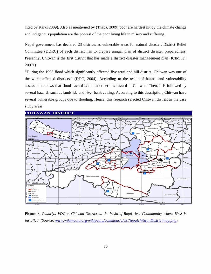
Chapter III Study Area
3.1 Study Area and National Context:
Nepal is considered as a disaster risk country where various disasters take place frequently. The
cause for the disaster is not only the topography condition and extreme climate but also exacerbate
by rapid population growth. Floods and landslides are the major natural hazard in Nepal. Regarding
with the disasters, the poor construction and lack of public awareness of the community in disaster
risk area makes the cope for emergency time in Nepal is very weak (Pokharel, 2004). Consequently,
it is increasing the vulnerability group in Nepal more and more (NSDRM, 2008).
The study area will be in the central part of Nepal in a district named chitwan which is in the inner
terai region of Nepal. Bhandara sits on the East Rapti river, 23 Kms east of Narayangadh
(Bharatpur), the district capital of Chitwan. In common with many riverside settlements in Chitwan
and eastern Nawalparasi the opposite bank of the river is occupied by the Chitwan National Park, the
thick vegetation of which protects the southern bank and encourages flood waters to erode and
inundate communities on the northern bank during the annual monsoon
The VDC is located to the river bank of Rapti River. And this community was one of the worst
affected by the flood in 2000. The study area is the Bhandara VDC, Padariya of Chitwan district
ward 7, where approximately 225 household of different caste system resides.
This community was displaced in the flood of 1992, 1998 and 2000 and during the flood they lost
their agricultural land, house and many livestock.
Most of the people in the area are farmers and work in their agriculture land and have livestock as
their main source of income. Other than this vegetable farming, and other occupation like teacher,
bank staff and labour in the gulf countries are the means of their alternative livelihood (Ghimire,
2007) for the people in the study area. Most of the people in the area are indigenous population and
ethnic minorities. Indigenous population in Nepal are more marginalized in social, economic, and
also in education sector.. Being poor and marginalized people are more vulnerable to climate change
as they have less knowledge and they live in vulnerable places (i.e. River bank) (Ghimire 2007 as
20
cited by Karki 2009). Also as mentioned by (Thapa, 2009) poor are hardest hit by the climate change
and indigenous population are the poorest of the poor living life in misery and suffering.
Nepal government has declared 23 districts as vulnerable areas for natural disaster. District Relief
Committee (DDRC) of each district has to prepare annual plan of district disaster preparedness.
Presently, Chitwan is the first district that has made a district disaster management plan (ICIMOD,
2007a).
“During the 1993 flood which significantly affected five terai and hill district. Chitwan was one of
the worst affected districts.” (DDC, 2004). According to the result of hazard and vulnerability
assessment shows that flood hazard is the most serious hazard in Chitwan. Then, it is followed by
several hazards such as landslide and river bank cutting. According to this description, Chitwan have
several vulnerable groups due to flooding. Hence, this research selected Chitwan district as the case
study areas.
Picture 3: Padariya VDC at Chitwan District on the basin of Rapti river (Community where EWS is
installed. (Source: www.wikimedia.org/wikipedia/commons/e/e9/NepalchitwanDistrictmap.png)

21
Other than this, climate change and global warming, is melting the glaciers increasing the frequency
of flood so these community would be ideal for the study and to know about the fact on flood threat
and existing EWS in the community.
22
Chapter IV
Materials and Methods
4.1 Conceptualization and Research Question Identification
Disaster has been a vexing issues and challenge for development all around the globe. Floods change
has its impact on the livelihood of the poor in rural areas and people in the bank of the river.
Recognizing this fact the topic was chosen to explain on the how people perceive EWS in their
community and their responsive mechanism during the emergency, Impact of flood on regular basis
despite the EWS was installed and sustainability of the system itself in the community was what give
rationale for undertaking this research. The concept on the research topic was therefore visualized
and as the problem was severe, Chitwan district, Rapti basin was taken and Padariya VDC ward- 7
was taken as unit of study. Based on some of the literatures as well as the site visits, research
questions were developed. These research questions are dealt in chapter II.
4.2 Proposal Preparation, Presentation and Integration of the Comments
Based on the literature review, together with the gaps identified in case of Nepal and community
level EWS were scrutinized, the proposal was prepared and presented. Dissertation seminars during
the third semester were helpful for the preparation of proposal. Many comments and suggestions
were obtained and they were integrated for undertaking the research activity.
4.3 Methods:
The study of need of early warning system and perception of local populations is increasingly
forwarded as an urgent research needs (Marasini, 2008,). Since the emphasis of this research is
to undergo an examination of perception of people regarding the early warning system and their
response in association with societies/ communities with in specific location, a case study
research strategy is used (Bryman 2008 ). In case study research, an exploratory questions,
‘’what’’ and ‘’how’’, and inductive research are most appropriate and helps to harness detailed
23
and valuable insights and understanding of the topic which could not be achieved by a survey (Yin
2003). The case study strategy is both ‘’qualitative and quantitative’’ (Yin 2003). Methodological
triangulation; obtaining data from different sources, such as observations, Focus group discussions
documentations and Key informants interview, helps to harnesses diverse ideas about the same issue
and assist in cross-checking the results, and consequently helps to increase the validity,
reliability of the findings and eases data analysis (Bryman 2008; A. Rialp, & J. Rialp, 2006).
4.3.1Review of relevant literature and Information
This was one of the methodologies that were followed in order to develop a clear understanding of
the concept of EWS a. In order to broaden the ideas and concept about the study, relevant reports and
documents will be reviewed. In addition to these, study reports, reports of other organizations related
to DRR(Disaster Risk Reduction), EWS, and existing policy and strategy related to DRR will also
reviewed to understand the issues and concerns of EWS installed in the different communities in
Nepal and in the context of other countries.
As part of the review of secondary information collection, workshop reports, and lesson learnt by the
donors in the EWS, fact and figures from the local office will be used to broaden the concept and
perspective of the study. A very few EWS installed in the country and very few published and
unpublished material for literature review will be a challenge for the collection of the data but study
tries to relate with the other relevant study done in the other place with similar pattern of framework.
4.3.2Source of Data:
The source of information for the study will be the primary data source and secondary data. In this
study, the current perception, response mechanism, stakeholders map will be assessed by
collecting primary data from respondents (focus group discussion interviews, field observation ) and
secondary data (disaster loss by previous flood, government initiative after the past flood and
published and unpublished information). The data on EWS and its usefulness to the community,
community perception on the message will be collected from group discussion with community,
interview with government, officials, and interview with key informants at local level. Further field
observation through transect walk will be used and secondary data from government offices and
other relevant literatures will be studied.
24
4.3.3 Data collection tools:
Focus group discussion (FGD) will be used from the community as for collecting primary
information or data. There will be interview with the government officials and other key informant
on the basis of information. It is required to verify the communities’ perceptions through experts’
opinion. Some stories will also be given in the report as to give the descriptive picture on the EWS
from the community people regarding the perception.
i. Building Rapport with local level stakeholders
Preliminary meetings will be organized with local level stakeholders to share the purpose of the
study. It was useful to select the study community and clusters within the community.
ii. Modality of the selection of community
River basin concept will be while selecting the study community i.e. the Padariya- 7 of Bhandara
VDC in the Basin of Rapti River in Chitwan district would be the possible community. It will help to
explore the perspectives and issues of EWS, its perception to the beneficiaries and response in the
time of emergency as due to the frequency of disaster is increasing and the people living in the river
regime are hampered and to increase resilience this study is most for further improvement in the
warning system and forecasting.
iii. Hazard Mapping:
Hazard mappings exercise is useful to know the context of people's vulnerabilities from hazard,
occurrence of disastrous events. In the exercise, people were requested to show the social
infrastructures along with major vulnerabilities to hazards, the most affected areas from hazard by
sketching the community map. The symbol for the appraisal was made on the basis of agreed
consensus of the people.
iv. Time Line Analysis:
This is another important tool for the research. This tool was helpful to understand the different level
of responses people in the community will do on the basis of lead time. Lead time was allocated to
the people up to 7 days. During the exercise people discussed their responses in accordance to
25
different types of livelihood resources.
v. Key Informant Interview (KII):
In order to validate the information from the discussion with community KII was done with the
different government line agencies at village level. Unstructured interview was done to verify the
answer.
4.3.4 Data collection procedure
First and foremost relevant literature and information about the place will be gathered. After that
different reports and research done in the sector of EWS in the country will be analyzed after that
consultation with local experts, government officials would be done .To know about the place and to
know the people of the area reconnaissance survey will be done. Participatory tools would be used to
collect data with the community people, suggestion and necessary adjustment will be done
accordingly. After that collection of data with people and local experts and people in the government
office face to face unstructured interview will be done to avoid duplication and ensure more
reliability and transparency on the data’s and information.
4.3.5 Data analysis Procedures:
The first part will show the district profile and places followed by quantitative on the trends of Socio
– economic condition. The second and third part presents the people’s perception regarding the EWS,
and consequently community’s response on the basis of warning message will be presented based on
the data gathered during the field study which will be more qualitative in nature. And qualitative data
will be provided in a descriptive way under different headings as the findings and discussion of the
findings is on the separate chapter. Finally study will try to give some recommendations for the
future intervention in the particular community and for the improvement of the EWS.
4.3.6 Sample Size:
For the research to sample size is necessary as it not possible to use whole population in the place.
So, for saving time and obtaining the accurate result with limited money is helpful from sampling. So
for this particular research convenient sampling would be use.

26
For this research local beneficiaries of the community took part in focus group discussion and they
were 8 in number. Other few were involved in the key informant’s interview .While selecting the
sample gender balance was maintained and inclusion of the children was also being taken in account.
27
Chapter V
RESULTS
5.1 Introduction As part of the dissertation objectives which have been listed in the previous chapter and to answer the
research question, it is required to collect appropriate data from the field. The primary data set used
in this research were collected by conducting resource mapping, focus group discussion, key
informant interview, Whereas secondary data has been obtained from concerned stakeholders. These
data are required to meet the objectives. The first step of data collection is pre-fieldwork phase in
which preparation has been done. The various stages that have been done are as follows:
1. Designing data collection approach;
2. Making a fieldwork schedule;
3. Making an appointment with the stakeholders;
4. Making reservation for accommodation in chitwan;
5. Making list of data to be collected.
This chapter has been started by the socio economic description of the community then description of
the different tools used for data collection can be seen. Further people perception of flood early
warning is described. Then the responses by the people on the basis of warning are also discussed.
5.2 Socio Economic Description of Padariya:
Padariya is one of the wards in Bhandara VDC which is situated in the bank of Rapti river.
According to the information from DWIDP and DAO, flooding hazard areas of Chitwan always take
place with return period of 8 years in Bhandara Village/VDC. Most the areas in Bhandara village is
located along Rapti River are Flash flood risk area. Same as information of Chitwan District Disaster
Management Action Plan (2004) shows that Bhandara village is in the very high flood hazard status
of Chitwan. Therefore, this research has selected Padariya as case study area.
28
5.2.1 Human Assets in Padariya:
The total population of Bhandara VDC at the time of the census of 2001 it had a population of
10,424 people living in 1795 individual households. Padariya has total population of 1280 people
living in approximately 315 households. Among 1280 49.38% is male and 50.62% is female (VDC
profile, 2010). The main source of livelihood in the place is agriculture (75%), cattle farming (15%),
and Agricultural labor (4.85%), fishing (2.15%), Commerce and Service (2.5%) others (0.5%) (ibid).
5.2.2 Social Assets:
Several NGO’s are working in the VDC so they have institutional support regarding the promotion of
livelihood. People of the village also has their own cooperative which has saving and also busy
different dairy products and agricultural commodities from the people which helps to make good
market linkages for the farmers. Friends, relatives and neighbor in the community plays vital role in
the time of crisis and extend their support. Feale have no strong voice in the community and in
decision making process though they are partially affiliated with the NGO activities.
5.2.3 Natural Assets:
The study area is rich in natural assets as it lies very close to the national park. Total cultivable land
in the area is 1500 hectares and bare land is 10 hectares (DAO, 2008). In the southern part of
Padariya, Chitwan national park lies which are divided by Rapti in the middle. The people of
Padariya also have their own community forest from which they have access to timber, firewood and
fodder for cattle’s.
5.2.4 Physical Assets:
Community has school, temple as a part of physical asset. Most of the house hold have corrugated
sheet roofs with brick and cement walled(40%),30% of household are with bamboo and straw roof.
80 percent of the people in the community have groundwater for drinking and other household
activities,. As the place is frequently flooded none of the houses in the community has raised their
plinths.
29
5.2.5 Financial Assets:
Different people from different castes reside in the community. Brahmin and Chettris are financially
strong in the community where as indigenous and tribal castes like Tharus, Rai, Magar doesn’t have
enough saving so they depends on elites class for the loan. Also there are different cooperative and
microfinance institution from where they take loans. Most of the lower castes people depend on their
male member of the family to earn their livelihood. Male members from the marginalized community
work as agricultural labor or daily wage labor.
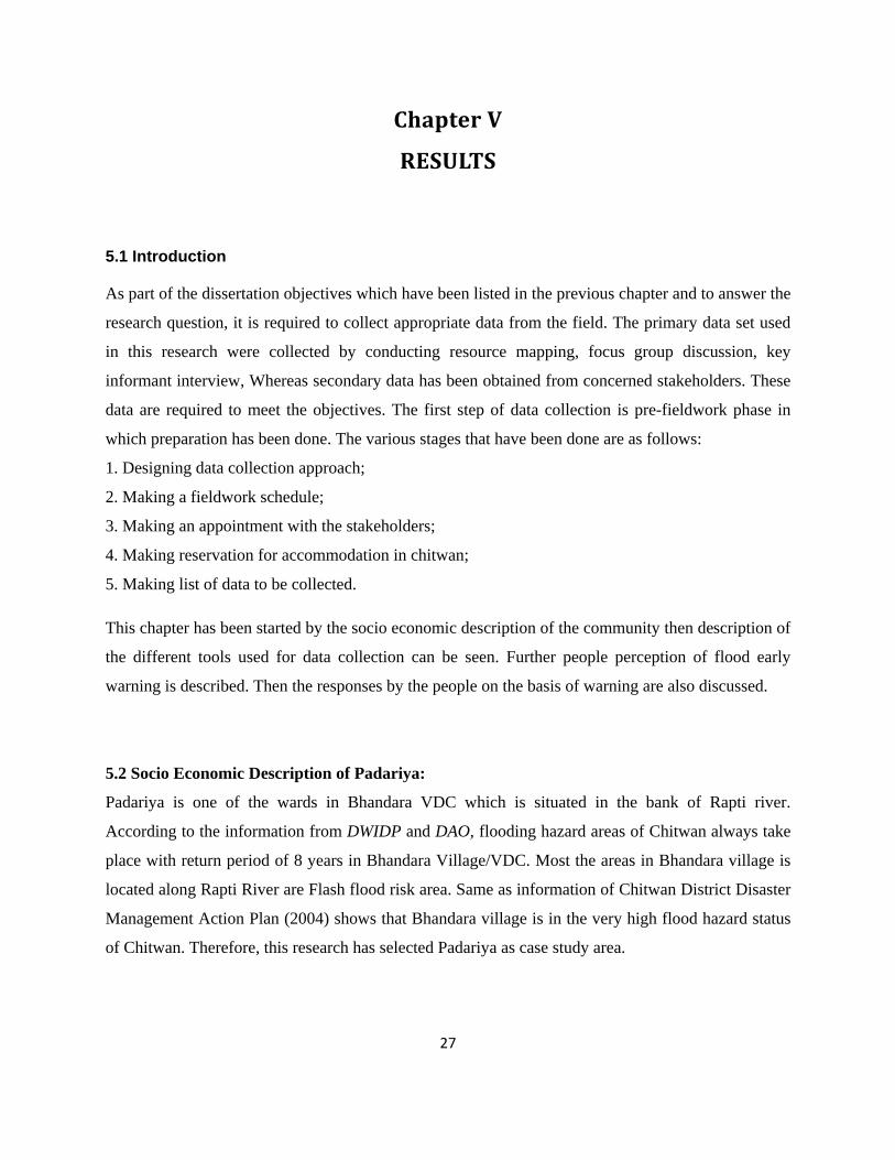
5.3 Resource mapping:
With the help of resource mapping vulnerable areas were identified in discussion with the
community. During the discussion with the community
areas to be affected by floods, river cutting were shown
in the maps.
Agricultural lands which are constantly under the threat
by local hazard were also identified. People were
requested to show the social infrastructures along with
major vulnerabilities to disasters, the most affected
areas from floods in the recent past, etc by sketching the
village map in the ground. In this process altogether 8
people participated.
Pic 4: Resource Map
People were from different livelihood group i.e. farmers, local leaders, school teachers, housewives,
agricultural labors etc were the participants in the mapping exercise.
Further mapping exercise also lead to some vital information on the causes of floods in the area i.e.
filling of river bed with soil and gravels from that are carried by the river form the hills in the
upstream. During the discussion the respondents agreed that deforestation and rapid population
growth are the other major causes of floods in the area. As the rain falls it directly get in to the
30
ground which loosens the grip of the soil and surface runoff is increased leading to landslide and
flooding in the downstream.
The agricultural land in these areas can grow rice, maize and different kind of vegetables throughout
the year but due to the flood threat people feel insecure in investing the money for the monsoon
farming of paddy. Low income groups like daily laborer and especially who depends on river and
forest for their livelihood are under serious problem as are not financially resilient towards the
hazardous event. Respondents were unsatisfied with the EWS installed in the area as not much of the
training and exercise were given to them from the NGO.
Within the resource mapping stakeholder involvement was also analyzed but most of the respondents
agreed that only the local elites and VDC officials were involved at the community level but there
was no accountability towards the under privileged and indigenous people living in the community.
5.4 Focus Group discussion:
Focus group discussion was carried out in the field to know about the EWS in the community. Focus
group discussion was held with the beneficiaries of the system. Local people from various livelihood
and economical background attended the FGD session. FGD was done around one and half hours in
the school building of the community. Information on how beneficiaries sees the EWS, flood
information, indigenous knowledge and coping mechanism and responses were collected from the
focus group discussion and recommendation were also seek from the people to improve the
prevailing EWS in the community.
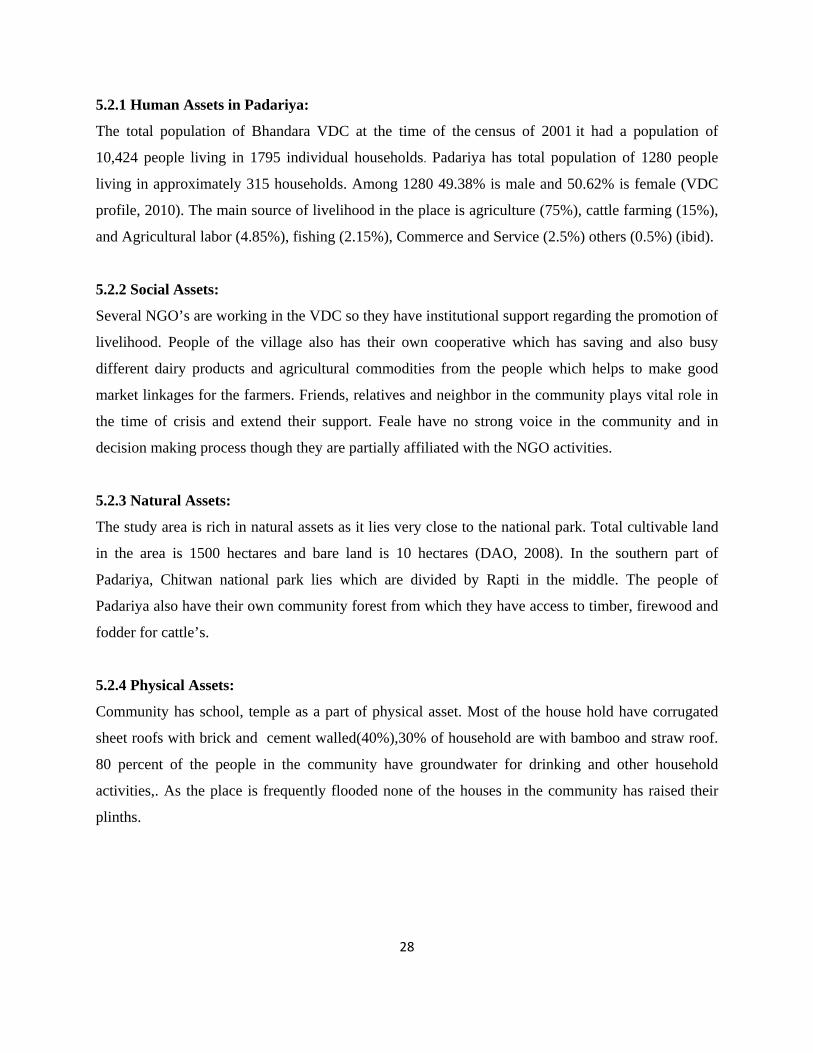
5.5Key Informant interview:
Key Informant Interview was taken with 3people. Key
informant represents different line agencies at district i.e.
Village development committee secretary, Political leader,
school headmaster. Other Than this local NGO’s focal person
31
and elites of the local area were taken the interview on the basis of information needed. Beyond
helping as a good source of providing comprehensive information regarding the early warning issues
in the community they were also helpful in clarification of gaps created during community exercise.
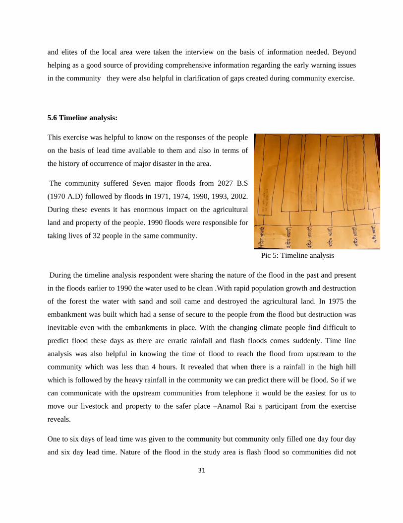
5.6 Timeline analysis:
This exercise was helpful to know on the responses of the people
on the basis of lead time available to them and also in terms of
the history of occurrence of major disaster in the area.
The community suffered Seven major floods from 2027 B.S
(1970 A.D) followed by floods in 1971, 1974, 1990, 1993, 2002.
During these events it has enormous impact on the agricultural
land and property of the people. 1990 floods were responsible for
taking lives of 32 people in the same community.
Pic 5: Timeline analysis
During the timeline analysis respondent were sharing the nature of the flood in the past and present
in the floods earlier to 1990 the water used to be clean .With rapid population growth and destruction
of the forest the water with sand and soil came and destroyed the agricultural land. In 1975 the
embankment was built which had a sense of secure to the people from the flood but destruction was
inevitable even with the embankments in place. With the changing climate people find difficult to
predict flood these days as there are erratic rainfall and flash floods comes suddenly. Time line
analysis was also helpful in knowing the time of flood to reach the flood from upstream to the
community which was less than 4 hours. It revealed that when there is a rainfall in the high hill
which is followed by the heavy rainfall in the community we can predict there will be flood. So if we
can communicate with the upstream communities from telephone it would be the easiest for us to
move our livestock and property to the safer place –Anamol Rai a participant from the exercise
reveals.
One to six days of lead time was given to the community but community only filled one day four day
and six day lead time. Nature of the flood in the study area is flash flood so communities did not
32
believe that six days lead time is possible. Community gave information regarding arrangement of
necessary shelter for livestock and people of the community, medical arrangement, communication
arrangement with the district headquarter, saving some money for the crisis time, preservation of
firewood’s and some food items to use during the crisis.
5.6 People’s perception on EWS and Response:
The prerequisite for effective early warning is the strong recognition of the human dimensions of
early warning mechanisms (UNISDR, 2008). Early warning messages must reach, be understood,
believed and personalized by the public at risk, in order to be acted upon so as to reduce immediate
exposure to hazards. Therefore community involvement is essential to the design of locally efficient
and socially relevant early warning systems.
As part of a larger investigation of intangibles associated with the assessment of flood management
projects the author studied attitudes to Early warning system for flood in Padariya -7 of chitwan
district in Nepal. While studying some components of perception on flood risk are also essential to
correlate with the study. Flood hazard, to some is natural (uncontrollable), to others man-made
(controllable), and yet to others both natural and man-made (Correia, et al., 1990). Flood perception,
among people who believe that it is not natural, may vary for people living along different rivers or
for people along the same river over decades or centuries (Wohl 2000). In some cases, low levels of
awareness of the risk, has encouraged complacency. A study of inhabitants of Polish regions struck
by the disastrous floods of 1997 and 1998 revealed that their perception of the risk was low and the
majority (70%) of participants in the study admitted that they did nothing to minimize the danger of
floods or to protect themselves (Kruszewski & Madej 2000). The study in Padariya people have low
awareness level regarding the operation of EWS and as they were living in the floods for decades
they know the way of responding if there is a flooding in the area.
On the other hand, while flood protection structures are designed to provide a specific level of
protection, they are perceived to fail when their design capacity is exceeded.
Often people realize that they are living and working in a hostile environment but also believe no
amount of protection will ever make them totally safe from floods (Gough, 2000). The belief that
33
floods are inevitable not only deters people from seeking mitigation solutions, but also causes a
distrust of flood management practices (Wohl, 2000).
If people believe that a structure protects them from flooding, they are more likely to build in the
floodplain as in the study area after the embankments are constructed in 1975 more people started
living there starting the agricultural production. Flood-control structures such as embankments or
dams may create a misleading sense of security with people assuming that floods will no longer
occur. Structural flood protection measures increase the attractiveness of the floodplain as a location
for development, by increasing the perceived safety from hazard (Bollens et al.1988). but the EWS
system installed in the community is of no use as it is not under operation and people had no
ownership of the system as the operation cost is the issue . Ram Bahadur Gurung a local resident of
study area explains - initially we had faith in this technology as the Ngo had kept watchmen in the
tower to monitor the behavior of the river. Ngo left and we were not even consulted regarding the
handover issue of the system. And now you can see as it is out of order and not under operation. We
have lost faith in it. Now we feel like embankment is saving us from the flood not the tower.
User based approach in forecast and warning aims in matching user’s information and information’s
needs. Traditionally in Nepal only weather forecasts produced by department of hydrology and
meteorology are mainly targeted to the people at district and central level. When floods are
approaching warning message should be given to the people who are likely to be affected by the
flood.
Early warning system in Padariya initially was seen as a milestone for the community but till date
even a single study has not been done by the NGOs to know how people perceive on the system that
is in the community in line with flooding risk. During the FGD with the people of the community
were hostile about the EWS that was installed in the community as, the tower was built in 2002 and
the same year flood occurred in the village but system was not useful for the people of the
community. Due to the nature of the EWS it was not so popular among the people of the community.
This watch tower needs a watchmen to look after the river but after the NGO left then it’s out of
business even in the monsoon – says Rajendra lama (local teacher at primary school).
Lokraj Silwal local elite and social workers explain -The tower is made at low level, trees are taller
than tower. It is hidden under dense forest. So to make proper utilization tower should be made at
34
higher place, near to river, made clearly visible. Tower made seems to be benefiting only political
parties’ n leaders and not the community people. Not a single community people were consulted
before the installation of the tower.
Early warning facility that exists in Padariya can give warning with 2-4 hours of lead time which is
only sufficient for saving the lives and livestock only. Community perceives that if there is 7 days
lead time then they would be able to save their crops and other valuable goods.
According to the respondents looking back to the flood history flood has always come during the
night time so the challenges still remain on delivering the warning message before the nightfall. And
siren in the watch tower cannot be heard during the heavy rain fall is another constraints in the
system. People in the area never receive information from any media and government authorities
regarding the forecast and warning of the flood.
In the research site most of the people believed to go and see river by themselves during monsoon
from the embankment and can assume whether there would be flooding or not using their traditional
flood knowledge which is discussed briefly in section 5.7 of this chapter.
For the effective EWS the characteristics of the population under threat need to be considered for
example disabled, old age, and lactating mother need more time to respond as they have mobility
problem so warning system need to have an effective. Other than this people living in the lower part
of the village are first to be affected by the rising flood waters these things needs to be taken into
account.
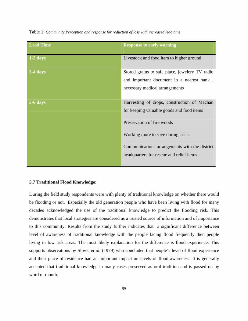
35
Table 1: Community Perception and response for reduction of loss with increased lead time
Lead Time Response to early warning
1-2 days Livestock and food item to higher ground
3-4 days Stored grains to safe place, jewelery TV radio
and important document in a nearest bank ,
necessary medical arrangements
5-6 days Harvesting of crops, construction of Machan
for keeping valuable goods and food items
Preservation of fire woods
Working more to save during crisis
Communications arrangements with the district
headquarters for rescue and relief items
5.7 Traditional Flood Knowledge:
During the field study respondents were with plenty of traditional knowledge on whether there would
be flooding or not. Especially the old generation people who have been living with flood for many
decades acknowledged the use of the traditional knowledge to predict the flooding risk. This
demonstrates that local strategies are considered as a trusted source of information and of importance
to this community. Results from the study further indicates that a significant difference between
level of awareness of traditional knowledge with the people facing flood frequently then people
living in low risk areas. The most likely explanation for the difference is flood experience. This
supports observations by Slovic et al. (1979) who concluded that people’s level of flood experience
and their place of residence had an important impact on levels of flood awareness. It is generally
accepted that traditional knowledge in many cases preserved as oral tradition and is passed on by
word of mouth.
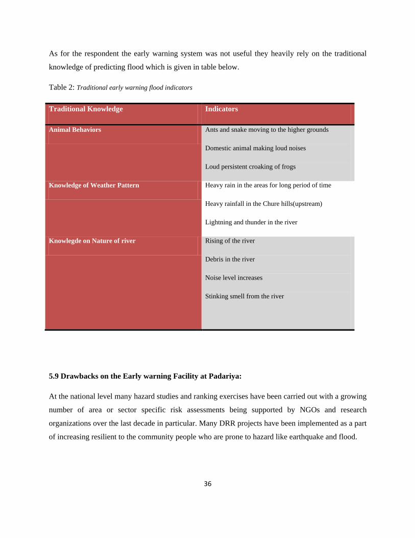
36
As for the respondent the early warning system was not useful they heavily rely on the traditional
knowledge of predicting flood which is given in table below.
Table 2: Traditional early warning flood indicators
Traditional Knowledge Indicators
Animal Behaviors Ants and snake moving to the higher grounds
Domestic animal making loud noises
Loud persistent croaking of frogs
Knowledge of Weather Pattern Heavy rain in the areas for long period of time
Heavy rainfall in the Chure hills(upstream)
Lightning and thunder in the river
Knowlegde on Nature of river Rising of the river
Debris in the river
Noise level increases
Stinking smell from the river
5.9 Drawbacks on the Early warning Facility at Padariya:
At the national level many hazard studies and ranking exercises have been carried out with a growing
number of area or sector specific risk assessments being supported by NGOs and research
organizations over the last decade in particular. Many DRR projects have been implemented as a part
of increasing resilient to the community people who are prone to hazard like earthquake and flood.
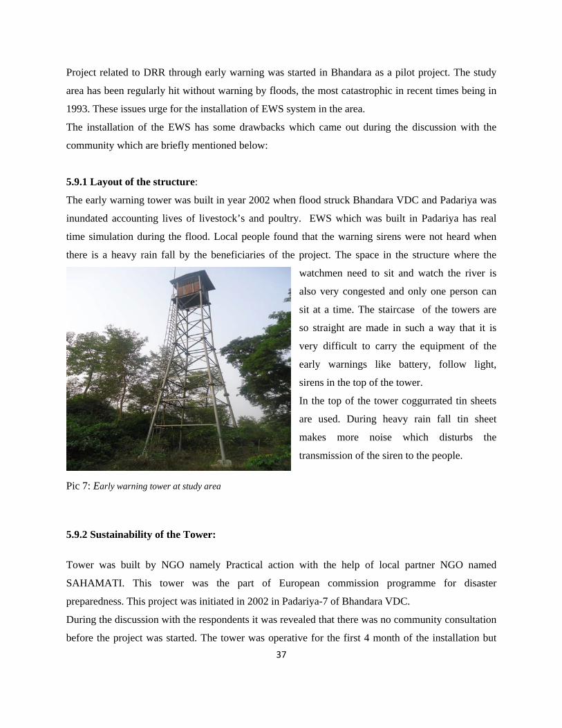
37
Project related to DRR through early warning was started in Bhandara as a pilot project. The study
area has been regularly hit without warning by floods, the most catastrophic in recent times being in
1993. These issues urge for the installation of EWS system in the area.
The installation of the EWS has some drawbacks which came out during the discussion with the
community which are briefly mentioned below:
5.9.1 Layout of the structure:
The early warning tower was built in year 2002 when flood struck Bhandara VDC and Padariya was
inundated accounting lives of livestock’s and poultry. EWS which was built in Padariya has real
time simulation during the flood. Local people found that the warning sirens were not heard when
there is a heavy rain fall by the beneficiaries of the project. The space in the structure where the
watchmen need to sit and watch the river is
also very congested and only one person can
sit at a time. The staircase of the towers are
so straight are made in such a way that it is
very difficult to carry the equipment of the
early warnings like battery, follow light,
sirens in the top of the tower.
In the top of the tower coggurrated tin sheets
are used. During heavy rain fall tin sheet
makes more noise which disturbs the
transmission of the siren to the people.
Pic 7: Early warning tower at study area 5.9.2 Sustainability of the Tower:
Tower was built by NGO namely Practical action with the help of local partner NGO named
SAHAMATI. This tower was the part of European commission programme for disaster
preparedness. This project was initiated in 2002 in Padariya-7 of Bhandara VDC.
During the discussion with the respondents it was revealed that there was no community consultation
before the project was started. The tower was operative for the first 4 month of the installation but
38
after the pilot project phase out from the area it is just a tower standing in the bank of the river.
People don’t use tower in the monsoon but they go to the embankment to see the behavior of the
river.
Respondents of the study have no ownership of the project as they were not involved with the project
from the very beginning. So, the project after phasing out its is only the tower standing in the bank of
Rapti river with structure and its component theft from the structure is a great challenge for the
sustainability for the EWs at Bhandara.
39
Chapter VI
CONCLUSION AND
RECOMMENDATIONS
In Nepal, flooding has been a vexing issues from the past and with the climate change scenario its
frequency has increased (Regmi etal, 2007) increasing the vulnerability of the people residing in the
bank of river. For hundreds and often thousands of people each year monsoon related floods result in
massive loss of property, erosion of land, destruction of irreplaceable assets, death of live stock,
spoiling of stored food stuffs and ultimately, loss of life.
Many NGOs in particular are actively engaged in DRR activities in Nepal. These have spread the
understanding and practice of numerous risk reduction and capacity building activities, to the extent
that many risk prone communities. EWS in Padariya is the result of some of the DRR activities that
was carried out in the vulnerable community of Nepal. The concept of early warning being new, it is
best introduced as part of a more general DRR project, particularly one providing more immediate
tangible benefits.
Regarding the perception towards the system people were getting it of no use at present in their
community for warning dissemination but people in the study areas knows its importance if used
properly for forecasting and warning of the flood hazards. Moreover, they have seen some prospect
in the system to make it sustainable through bird and animal watching in the tourist season. EWS in
the study area proved to be useless for the people of Padariya. People felt that system was of no use
for them as it was a pilot project and it failed to meet the expectation of the community people. Other
than this the structural deficiency in the tower was the important factor which make it unpopular
among the beneficiaries of the project. For the success of the project community involvement from
the designing to completion is must. This helps the community about the project and helps to build
the feeling of ownership of the work. More on the software part was needed for this EWS as donor
investment in the hardware part of the project.
Further, community consultation which was not taken into account during the project time in the area
was one of the roots cause which failed to know about local need priorities and perception which
40
could have positive impact of the pilot project and would make it a success. People in Padariya
respond to the disaster as per their experiences from the past disasters. People also use some
traditional knowledge for forecasting the flood in Rapti River and move to the nearest market or
higher grounds with their valuables and livestock. But people with the lead time of one day to seven
day could respond to a flood in different ways by harvesting their crops, saving money for the crisis,
collection of firewood’s etc.
People response during the flood was only to save their live and livestock as the flash flood occur in
the region. So lead time of more days could help them in saving their crop, small scale industries and
other valuables which are needed to be focus which is only possible through use of scientific
techniques which need to be explored form the concerned authorities.
Early warning has always been considered a cornerstone of disaster risk reduction. During the past
decade, many activities promoted the benefits and feasibility of early warning, and identified major
strengths and weaknesses of related capacities around the world. The first prerequisite for an
effective early warning system is the recognition of the benefits of early warning in protecting
societies. With the lack of technology and financial resources Nepal is lagging behind for the
improvement of the early warning system in the different part of the country especially Padariya 7
Bhandara VDC. For improving the early warning system of Padariya recommendations are briefly
discussed:
Communication requirements:
People have emphasized the need for forecasting and issuance of warning from concerned
stakeholders. Coordination between different government line ministries will help people to get the
information for saving their properties and lives. So, essential coordination’s to communicate the risk
of flooding is required to take proper decision and action in response.
Application of scientific forecasts:
Clear and reasonable access to relevant early warning information for beneficiaries of EWS is
necessary but not sufficient. Advances in forecasting and monitoring must be going together with
accurate and comprehensive vulnerability and risk information. Major efforts should be undertaken
in the coming years to assess vulnerabilities, generate risk scenarios and vulnerability maps, based on
standardized methodologies. Further collaboration with weather satellites from the region can also be
acquired for better forecast through scientific means.
41
More attention should be devoted to developing user-friendly products for decision makers and
communities at risk regarding the forecast. This will require a better understanding of user needs and
preferences on how information should be presented as forecast and how to apply it in the decision-
making process i.e. warning.
Public knowledge and participation User-oriented warning information can only become a reality with the structured and focused
involvement of the public from the very beginning of the project. People need to understand the risks
they face, be aware of the existence of the warning system, and understand the appropriate early
warning reactions.
Issuers of warnings need to understand better those people at risk and what form of information is
needed to secure effective responses to the warnings. Public participation is the key to trustworthy
and credible early warning systems. This includes the full and equal gender balance. Integrated
information systems that ensure community participation in national early warning strategies need to
be developed. Further Different programmes related to warning messages and forecasting should be
given in local Medias which will help people to prepare for the upcoming hazardous event.
Public participation is also essential for the regular testing of warning systems and in providing
feedback for improvement and creates positive perception among the beneficiaries.
Promotion of Traditional Knowledge:
Traditional knowledge has always provided a platform for new inventions around the world. People
of Nepal are rich in traditional as they have been living with flood for many decades. Traditional
knowledge need to be improvised and should be promoted in close line with scientific tool and
techniques for forecasting and warning of the flood risk.
Upstream and Down Stream Linkages:
In Nepal due to rugged and steep terrain the prevalence of Flash flood is very high in many part of
the country. Upstream community can know the possibility of the flood so that they can inform the
communities in downstream. Other mechanism like use of telephone and communicating with the
police station nearby can help to disseminate the information among the people. When there is a
rainfall the people of upstream can inform the downstream communities about the rainfall. Thus the

42
time to time community visit, interaction between upstream and downstream or vice versa can be
done to have access of knowledge to the vulnerable communities.
References:
BBC, (2010). News South Asia retried, 18th
Bryman, A., (2008). Social research methods, Oxford New York.
March, 2011, from htpp://www.bbc.co.uk/news/world-
south-asia-10943606.
CBS, Central Bureau of Statistics, (2006) Environmental statistics Book, Nepal,
DDC, (2004). Chitwan district Disaster Management Action Plan, Chitwan, Nepal. District Development Committee (DDC) Chitwan.
Ghimire Bishnu Prasad, (2007). Social and Cultural Study of Indigenous Population in Chitwan District. District Development Committee, Chitwan [Original Nepali]
GTZ, (2002). Disaster Risk Management: Working concept Eschborn: Deutsche Gesellschaft Fur Technische Zusammenarbeit (GTZ) GmbH
International Labour Office.
Marasini Sambhu Prasad, (2008), “Country Paper on Disaster Risk Reduction Management in Nepal” Ministry of Home Affairs, GON.
NSET (2008), National Strategy for Disaster Risk Management in Nepal, NSET
Oxfam International, (2009). Even Himalayas has stopped smiling; Climate Change, Poverty and Adaptation in Nepal. Oxfam International.
Poudyal Chhetri, M. B. (2010) “Country Paper in Disaster Governance in Nepal” Disaster Preparedness Network Nepal.
Poudyal Chhetri, M.B. (1998) " Disaster Management in Nepal: Challenges Opportunities" an unpublished research paper, 1998 Kathmandu, Nepal.
Practical Action, (2009), “Early warning Saving Lives” Practical Action/ European Commission.
Regmi B.R. & A. Adhikari (2007), Climate change and human development – risk and vulnerability in a warming world ,Country Case Study-Nepal, LI- BIRD/UNDP, Nepal
Rialp, A. & Rialp, J., 2006. International marketing research: opportunities and challenges in the 21st century, UK: Emerald Group Publishing.
SHARMA, D. 2002. Coping strategies and early warning systems of tribal people in India in the face of natural disasters: case studies in Maurbhanj, Orissa and Durgapur, Rajasthan, India. New Delhi:
SLOVIC, P., FISCHHOFF, B. & LICHTENSTEIN, S. 1979. Rating the Risks.
Thapa Nar Bikram, (2009), Getting Prosperity through Farmer Led Agriculture, Ratna Pustak bhandar, Kathmandu.
UN HABITAT (2008). Post Disaster Project in Asia.
UN/ISDR; "Words into Action: A Guide for Implementing the Hyogo Framework"; Hyogo Framework for Action 2005-2015: Building the resilience of nations and communities to disasters. United Nations International Strategy for Disaster Reduction (UN/ISDR) Geneva, 2007.
UNDP, 2009, Human Development report, UNDP
UNDP, Reducing Disaster Risk: A Challenge For Development, United Nations Development Program (UNDP), 2004.
UNU ITC DGIM, 2009. Multi hazard risk assessment. Enscheda, the Netherlands: ITC and Associated Institution of the United Nation University.
WECS, (2002). Water Resources Strategy, Nepal Government of Nepal Water and Energy Commission and Secretariat, (WECS) IN Government of Nepal 2008.
Yin, R.K., 2003. Case study research: Design and methods, Sage Publications, Inc.
Recommended