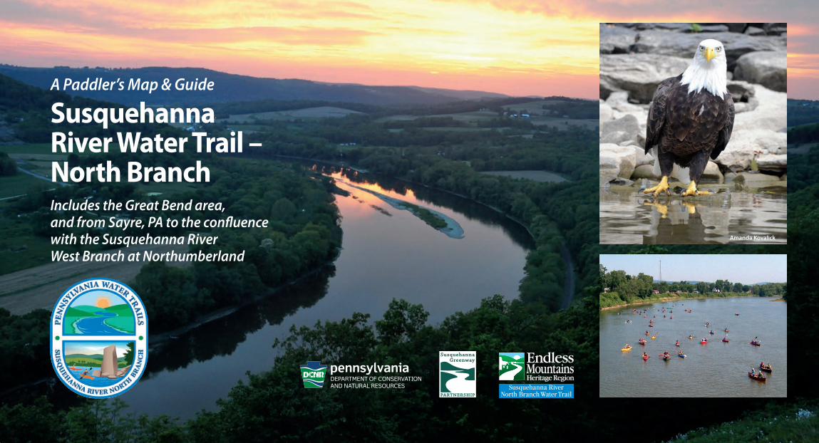
SusquehannaRiver Water Trail –North BranchIncludes the Great Bend area, and from Sayre, PA to the confluencewith the Susquehanna RiverWest Branch at Northumberland
A Paddler’s Map & Guide
Amanda Kovalick
9feb21-20pg-12x13-cx2.qxp_Layout 1 2/10/21 3:10 PM Page 1
NEW YORKPENNSYLVANIA
S U S Q U E H A N N A
B R O O M E
T I O G AC H E M U N G
W Y O M I N G
WAYNE
L A C K A W A N N A
L U Z E R N E
S U L L I V A N
LY C O M I N G
MONTOUR
N O R T H U M B E R L A N DS N Y D E R
U N I O N
C O L U M B I A
C A R B O N
M O N R O E
S C H U Y L K I L L
Dushore
EaglesMere
HopBottom
LittleMeadows
Forksville
Laporte
Montrose
Coaldale
ForestCity
Friendsville
Shenandoah
Thompson
MahanoyCity
McAdoo
Ringtown
Roseville
Kulpmont
McEwensville
Lewisburg
Benton
NewBerlin
Turbotville
Washingtonville
Orangeville
Stillwater
Millville
Nesquehoning
HarveysLake
Starrucca
Rome
Nicholson
Muncy
PennLakePark
Lehighton
Palmerton
WestHazleton
Factoryville
Freeland
BeaverMeadows
NewColumbus
Jeddo
Hughesville
Montgomery
Conyngham
JimThorpe
LeRaysville
Monroe
NewAlbany
ClarksSummit
Dalton
DicksonCity
Vandling
Moscow
Blakely
Owego
Williamsport
Hazleton
Carbondale
Scranton
BinghamtonElmira
Milton
SaltSpringStatePark
LackawannaStatePark
World’s EndState Park
RickettsGlenStatePark
NescopeckState Park
HickoryRunStatePark
BeltzvilleStatePark
FrancesSlocum
State Park
WYOMINGSTATE FOREST
TIADAGHTONSTATEFOREST
1717
17
92
220
66
2206
6
6
81
81
86
476
81
80
476
80
380
476
84
80
180
81
True North
12°32'
Magnetic North
Magnetic Declinationincreasing 1' annually
(as of 1 May 2007)
0
0
4 6 Mile2
10 Kilometer5 1
2
3
4
5
6
7
8
11
1314
Sunbury
Wilkes-Barre
Nanticoke
Pittston
SayreS lt
Hallstead
Northumberland
Berwick
Danville
Tunkhannock
LaceyvilleMeshoppen
Shickshinny
Wyalusing
Towanda
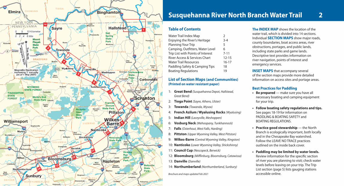
Susquehanna River North Branch Water Trail
Table of ContentsWater Trail Index Map 2Enjoying the River’s Heritage 3-4Planning Your Trip 5Camping, Outfitters, Water Level 6Trip List with Points of Interest 7-11River Access & Services Chart 12-15Water Trail Resources 16-17Paddling Safety & Camping Tips 18Boating Regulations 19
List of Section Maps (and Communities) (Printed on water resistant paper)
1: Great Bend (Susquehanna Depot, Hallstead, Great Bend)
2: Tioga Point (Sayre, Athens, Ulster)
3: Towanda (Towanda, Wysox)
4: French Azilum / Wyalusing Rocks (Wyalusing)
5: Indian Hill (Laceyville, Meshoppen)
6: Vosburg Neck (Mehoopany, Tunkhannock)
7: Falls (Osterhout, West Falls, Harding)
8: Pittston (Upper Wyoming Valley, West Pittston)
9: Wilkes-Barre (Central Wyoming Valley, Kingston)
10: Nanticoke (Lower Wyoming Valley, Shickshinny)
11: Council Cup (Nescopeck, Berwick)
12: Bloomsburg (Mifflinburg, Bloomsburg, Catawissa)
13: Danville (Danville)
14: Northumberland (Northumberland, Sunbury)
Brochure and maps updated Feb 2021
The INDEX MAP shows the location of thewater trail, which is divided into 14 sections.Individual SECTION MAPS show major roads,county boundaries, boat access areas, riverobstructions, portages, and public lands,including state parks and game lands.Descriptive text provides information onriver navigation, points of interest andemergency services.
INSET MAPS that accompany several of the section maps provide more detailedinformation on access sites and portage areas.
Best Practices for Paddling• Be prepared — make sure you have all
necessary boating and camping equipment for your trip.
• Follow boating safety regulations and tips. See pages 18-19 for information on PADDLING & BOATING SAFETY and BOATING REGULATIONS.
• Practice good stewardship — the North Branch is ecologically important, both locally and in the Chesapeake Bay watershed. Follow the LEAVE NO TRACE practices outlined on the inside back cover.
• Paddling may be limited by water levels. Review information for the specific section of river you are planning to visit; check water levels before leaving on your trip. The TripList section (page 5) lists gauging stations accessible online.
2
9feb21-20pg-12x13-cx2.qxp_Layout 1 2/10/21 3:10 PM Page 2
The key to an enjoyable trip on the watertrail is advance planning and safe boating.This guide will assist you in preparing for yourtrip. Included are maps, information on tripplanning, portages, safety, camping, andequipment to bring.
The North Branch meanders through some ofthe most remote and diverse plant and animalcommunities found in Pennsylvania. Trail userswill be presented with multiple opportunities to witness many of the more common species,and quite possibly a few of the state’s rarestones as well.
Eagles commonly soar high along the rockcuts. Peregrine falcons can be found nestingunder a bridge in the Wyoming Valley. Whitetaildeer, beaver, river otters, and great blue heronsare seen along the river banks, and the waterabounds with smallmouth bass and other fish.
Geologic OriginsThe fertile valleys of Northeastern Pennsylvaniahave supported scattered agricultural villagessince pre-historic times. The steep terrain,however, historically restricted travel throughthe region, limiting the creation of largesettlements. The majority of the region islocated on the Allegheny Plateau, a portionof the much larger Appalachian Uplands.
Glacial action and erosion over the eons have created a landscape of broad rolling hillscrisscrossed by an extensive network of valleysand streams. A prominent regional feature is theNorth Branch of the Susquehanna River, whichmeanders through Susquehanna, Bradford,Wyoming, Lackawanna, Luzerne, Columbia,Montour, and Northumberland Counties. Theriver was once a major transportation corridor,although its shallow rocky waters are nowconsidered unnavigable in the modern sense.
Following the retreat of the Wisconsin Glacier 15,000 years ago, the region underwent a gradual transformation from a relativelybarren, post-glacial landscape inhabited bynomadic bands of hunters and gatherers to a largely forested region supporting diversewildlife and small agricultural villages.
Historic PointsThe Susquehannocks, a powerful Iroquoian-speaking tribe, lived along the North Branchof the Susquehanna River at the time of theearliest European contacts. As they movedsouth, other peoples moved in, among themthe Delaware, or Lenni Lenape. A group ofthirteen mostly Algonquian tribes, they oncelived on the Atlantic coast. They were called“Delaware’s Indians” after Lord De la Warr,governor of the colony where they originated.
Like the Iroquois, who also settled in theregion, the Delaware were farmers. Bothquickly adapted to life in the rich SusquehannaRiver Valley, taking advantage of the river’sresources and abundant game. The NorthBranch Susquehanna River Valley becameknown as the “Breadbasket of the Indians,”supplying tons of corn and other foods for theDelaware and Iroquois peoples. The well-knownRoute 6 scenic overlook at Wyalusing Rocks wasonce a strategic lookout.
FriedenshüttenIn 1765, David Zeisberger establishedFriedenshütten, a Moravian mission, withDelaware people led by Chief Paupunhank atM’chwihilusing (Wyalusing). The mission closedin 1772 before the outbreak of the AmericanRevolution. Despite wars and removals, someNative Americans remained in the region, theircrops and agricultural techniques adopted byEuropean settlers.
Route of the North BranchIn Pennsylvania, the Susquehanna River NorthBranch Water Trail starts with a 15-mile-longpaddling journey from Oakland to Great Bendin Susquehanna County. The River enters New York State at river mile 340 for 49 miles. It re-enters the Commonwealth in Bradford
Enjoying the River’s Heritage & WildlifeCounty at Sayre and continues 166 miles,ending at Shikellamy State Park inNorthumberland - Sunbury at the confluencewith the West Branch of the Susquehanna.You will paddle through a region of beautifulmeandering river cuts in the Endless Mountainsand then through the Wyoming Valley,passing many river towns on your way to theconfluence. While following the North BranchWater Trail, you can see Native Americanlookout points, the remnants of a past canalsystem, and an area that was the hub of thenation’s anthracite coal and industrial boomin the 1800s.
Water Trail ManagementThe Susquehanna River Water Trail– NorthBranch is co-managed by the Endless MountainsHeritage Region and the Susquehanna GreenwayPartnership. More information about theseorganizations can be found on Page 16.The North Branch Water Trail serves as onebranch of the Susquehanna River Water Trail,which traverses the Commonwealth ofPennsylvania. As part of this larger system,the North Branch is also within the nationallydesignated Captain John Smith ChesapeakeNational Historic Trail.
3
9feb21-20pg-12x13-cx2.qxp_Layout 1 2/10/21 3:10 PM Page 3
North Branch Canal ExtensionNearly twenty years in the making from1836-1855, the extension of the North BranchCanal greatly contributed to the developmentof the region. The Canal connected Pittston,just north of Wilkes-Barre, to Athens in BradfordCounty and ultimately with the Junction Canalalong the Chemung River to Elmira, New York,and points north.
Laborers were contracted and work beganalong the river in 1836. By the end of the year,funds had been exhausted and work cameto a halt. In 1849 operations resumed and thebuilding of the canal moved forward, althoughslowly, until 1854 when the canal was completed.For a variety of reasons including expensiverepairs due to poor workmanship and harshwinters, and insufficient toll income, the canalwas sold in 1858 to the North Branch CanalCompany headed by a local man, C.F. Welles, Jr.
Anthracite CoalNortheast Pennsylvania is home to 98% of theanthracite coal in the United States. Hard coalcontains more carbon and burns hotter andcleaner than bituminous. In the Wyoming Valleyin the 1800s and early 1900s, most of the malepopulation worked in the coal industry.
Iron Heritage in DanvilleFounded on land purchased by General WilliamMontgomery in 1774 and named after his sonDaniel Montgomery, who laid out the town in1792. The first American iron "T" rail railroadtrack was rolled here in 1845 using iron oremined from the nearby Montour ridge. MarketStreet runs parallel to the river one block north,where many fine 19th-century homes reflectthe wealth of their iron mine and iron millowners who resided there.
FishingThe PFBC shares this informationon North Branch fishing:The entire North Branch has high numbers offish including smallmouth bass, sunfish, carp,walleye, muskellunge, and channel catfish.Very popular areas with anglers are where thefeeder streams enter the river. Some sectionsof the North Branch have been written aboutin popular magazines such as Field and Stream.
For more information, regulations andpermits for fishing and boating in Pennsylvaniavisit the PFBC website. fishandboat.com
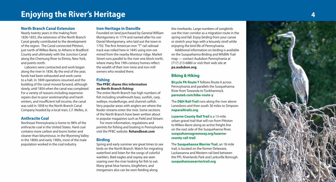
BirdingSpring and early summer are great times to seebirds on the North Branch. Watch for migratingwaterfowl and listen for the songs of colorfulwarblers. Bald eagles and osprey are seensoaring over the river looking for fish to eat.Many great blue herons, kingfishers, andmergansers also can be seen feeding along
the riverbanks. Large numbers of songbirds use the river corridor as a migration route in thespring and fall. Enjoy birding from your canoeor stretch your legs with a leisurely stroll whileenjoying the bird life of Pennsylvania.
Additional information on birding is availableon the Susquehanna Birding and Wildlife Trailmap — contact Audubon Pennsylvania at (717) 213-6880 or visit their web site atpa.audubon.org.
Biking & HikingBicycle PA Route Y follows Route 6 acrossPennsylvania and parallels the SusquehannaRiver from Towanda to Tunkhannock.paroute6.com/bike-route-y
The D&H Rail-Trail runs along the river aboveLanesboro and then south 30 miles to Simpson.neparailtrails.org
Luzerne County Rail Trail is a 13-mile urban gravel trail that will run from Pittston to Wilkes-Barre along an active freight line on the east side of the Susquehanna River. susquehannagreenway.org/luzerne-county-rail-trail
The Susquehanna Warrior Trail, an 18-miletrail, is located on the former Delaware,Lackawanna and Western rail bed between the PPL Riverlands Park and Larksville Borough.susquehannawarriortrail.org A
man
da K
oval
ick
4Enjoying the River’s Heritage
9feb21-20pg-12x13-cx2.qxp_Layout 1 2/10/21 3:10 PM Page 4
The North Branch Susquehanna is suitable forboth motorized and non-motorized watercraft,depending on the stretch of the river, flowconditions, and season of the year. Some181 miles long, it can be used for day trips orlonger journeys. The average speed of a canoepowered by two adults is 2–3 miles per hour.Novice boaters should plan on covering10–14 miles per day (paddle time about4–5 hours) or one trail section map.Experienced canoeists, with average waterand weather conditions, can plan to paddle20–24 miles a day and the entire route in8 –9 days. Novice paddlers should notattempt the full route.
Be sure your experience level matches thetrip — some sections may be more challengingthan others. If you are a novice boater orunfamiliar with the North Branch, complete aboating training course before setting out.Information on weather, river levels and tripplanning are available from outfitters, canoeclubs and other organizations. For specificinformation check the link to the water trailwebsite at emheritage.org
Dam Safety and PortagesThe North Branch has one dam in thePennsylvania section of the trail corridor. There are several dams on the New York section of the North Branch Water Trail near
Binghamton and you should carefully note their locations on the map, for all are potentiallydangerous. New York State law requires allboaters to stay at least 200 feet upstream and100 feet downstream from these dams. Eachdam must be portaged, by vehicle or by foot.
CAUTION: Susquehanna Depot Hydro Dam[in Pennsylvania] Susquehanna HydroelectricDam. Stay close to left shore. Take out 50 yardsupstream of dam on river left. Carry boatsaround the dam abutment to the path belowthe dam. USE EXTREME CAUTION approachingdam and entering water below dam. Keep boatsaway from turbulent water. When WindsorUSGS gauge reads 5 feet or higher, take out atthe Susquehanna Depot Access at RM 351 andportage 1 mile to the Front Street PrivateAccess: canoe launch next to the railroad bridgedownstream of Susquehanna Dam. Note: seeinset map on section map one: Great Bend.
Potable WaterWater is available at a limited number of siteslisted in the RIVER ACCESS table (pages 12-15).Take enough water for drinking and cookingto carry you between sites. River water may alsobe purified using commercial drinking waterfilters, iodine tablets, or by boiling for at least 10 minutes. While these methods will removemost biological pathogens, only some of the
commercially available filters will remove othercontaminants such as heavy metals orsediments.
Respect Private PropertyMuch of the land along the water trail is privatelyowned. Do not trespass. You should camp onlyat officially designated areas. The good will andstewardship of private landowners are essential
to sustaining the water trail and the river itself.Several access points, particularly in the upperreaches of the water trail, are on private land.These access sites are made available to thewater trail by special agreement with thelandowner, which is subject to change at anytime. Please check with the landowner prior to using these sites.
Additional information:
Binghamtoncityofbinghamton.com
Owegovillageofowego.com
Broome Countygobroomecounty.com
New York Departmentof EnvironmentalConservation
dec.state.ny.us
New York Section of the Susquehanna Water Trail
The Susquehanna river from river mile 340 to river mile 291 is in New York State.If paddling through this section use caution and be aware of low head dams and hazards in the Binghamton area.
Kirkwood Access point Kirkwood ParkConklin Access point Schurbusch ParkBinghamton Access point Sandy BeachBinghamton Rock Bottom Dam Portage RRBinghamton CAUTION: Dam Pipe crossing Binghamton Confluence Chenango RiverBinghamton CAUTION: Dam Twin 30 inch pipesBinghamton Goudy Station Dam Portage RLVestal Access point Harold Moore ParkEndicott Access point Grippen ParkApalachin Access point NYSDECOwego Access point Hickories ParkNichols Access point NicholsBarton Access point Barton Access
Planning Your Trip 5
9feb21-20pg-12x13-cx2.qxp_Layout 1 2/10/21 3:10 PM Page 5
Outfitters and Canoe LiveriesLocal outfitters are invaluable sources ofinformation about current river and weatherconditions and can assist with trip planning,camping information, transport around damsand canoe rentals:
Endless Mountain OutfittersSugar Run, PA (570) 746-9140 emo444.com
Susquehanna Kayak & Canoe RentalsFalls, PA (570) 388-6107 kayaktheriver.com
Five Mountain OutfittersShickshinny, PA (570) 885-0081fivemountainoutfittersco.com
Susquehanna Outdoor AdventuresBloomsburg, PA (570) 854-4333kayaktheriverpa.com
Riverside Adventure CompanyDanville, PA (570) 854-2437
Lake Augusta Boat RentalsSunbury, PA (570) 988-2804lakeaugustaboatrentals.com
Launch Tags - PFBCPennsylvania Fish and Boat CommissionLandings/Access areas require a launchpermit for all boats. Tags available at somelocal outfitters and on-line fish.state.pa.us.Launch permits are also required at DCNRproperties and State Parks. (888) 727-4741
Safe Paddling Levels - Gauge Station Readings
Location Gauge Number MAP Lower Good Upper Section Limit Paddling Limit. . . . . . . . . . . . . . . . . . . . . . . . . . . . . . . . . . . . . . . . . . . . . . . . . . . . . . . . . . . . . . . . . . . . . . . .
Windsor, NY 01502731 1 1 ft 3 ft 6 ftWaverly, NY 01515000 2 - 3 0 ft 3 ft 5 ftChemung, PA 01531000 2 - 3 2 ft 3 ft 6 ftTowanda, PA 01531500 3 - 5 Negative 0.5 ft 2 ft 5 ftMeshoppen, PA 01533400 6 - 8 7 ft 9 ft 13 ftWilkes-Barre, PA 01526500 10 - 11 0 ft 2 ft 5 ftBloomsburg, PA 01538700 12 - 13 1 ft 3 ft 6 ftDanville, PA 01540500 13 - 14 2 ft 4 ft 7 ft
River Flow and ForecastsReal-time information on river levels andforecast levels are available from the MiddleAtlantic River Forecast Center:http://www.erh.noaa.gov/er/marfc
Public and Privately Owned CampgroundsMile Owner Contact275.5 Larnard Hornbrook County Park Bradford County (570) 265-1719265.5 Riverside Acres Campground Private (570) 265-3235241.5 Endless Mountains Campground Private (570) 869-2580206.6 Susquehanna Shores Campground Private (570) 388-6921146.6 Indian Head Campground Private (570) 784-6150133.6 Wray's Riverfront Campground Private (570) 275-5783125.4 Fantasy Island Campground Private (866) 882-1307
CampingThe North Branch Water Trail passes severalnumbered State Game Lands. Camping isprohibited on Pennsylvania State GameLands. There are public campgrounds andareas to camp in municipal parks along theriver including some DCNR-owned islands.Prior camping permits are required at mostmunicipal parks along the river.
Contact phone numbers are provided onthe map sections. Public facilities should beused when available to minimize the impacton the river environment.
Please note that most of the river islandsare privately owned, camping or stopping isnot permitted without prior written permission.
IMPORTANT InformationPortage around all dams as noted onmaps and in notes. Be aware of safe riverlevels for paddling. Wear an approved lifejacket/Personal Flotation Device (PFD) anda carry whistle or noise device (by law).
Amanda Kovalick
River Gauge ReadingsCurrent readings from the U.S. GeologicalSurvey gauges: (717) 730-6900http://waterdata.usgs.gov/pa/nwis/rt
6Best River Levels, Outfitters & Camping
9feb21-20pg-12x13-cx2.qxp_Layout 1 2/10/21 3:10 PM Page 6
CAUTION – DAM350.5 RL, Susquehanna Depot, portage
around dam at Susquehanna DepotMunicipal Access. Alternatively, toavoid dam: use Front Street PrivateAccess 350.5 to Hallstead 342.5;8.0 miles; 2–3 hours
348.9 Mormon Monument, RR. Depictslocation where priesthood wasconferred on Church of Jesus Christ ofLatter-Day Saints founder Joseph Smith.
342.5 PFBC Hallstead Access
PFBC Sayre Access 290.5 to UlsterBridge Access 278.8;11.7 miles; 3 – 4 hoursSection Map #2 Tioga Point
Other Public Access:287.8 RR, Sayre Riverfront Park Borough 286.8 RR, Susquehanna Street Bridge Municipal
Stopping Points:286.6 Harrigan Island. Donated by Dick
and Amy Harrigan in 2006 for theuse of River paddlers.
286.6 RR, Tioga Point Museum.Path from river. Exhibits include localNative American artifacts, Sullivan’s Expedition, Stephen Foster, early canals and the Civil War.
286.5 RR, Fort Sullivan. Stone monument marking site of wooden fort built 1779 by General Sullivan’s expedition.
284.0 RR, Tioga Point, at confluence with Chemung River. Private property but stopping at the point is OK.
Overnight Stops:286.6 Harrigan Island, primitive campsite.
Points of Interest:288.6 RR, Lehigh Valley Railroad Station
Built in 1881.287.9 Carantouan Greenway, RR. Destiny
Kinal Loop Trail located at SayreRiverfront Park.
285.5 RR, Start of Tioga Point to river mile 284.Arrow-shaped landform at confluenceof Chemung and Susquehanna Rivers.Location of Teaoga, an Iroquois sentrytown. 1778 gathering point for Indiansand British allies before attacks onWyoming Valley settlements.
283.7 Tioga Point Overlook, RL. Scenic viewsoverlooking valley and the confluenceof Chemung and Susquehanna rivers.
281.0 RL, Sheshequin Universalist Church1827 church and cemetery with gravesof American Revolution soldiers fromBattle of Wyoming in July 1778.
Ulster Bridge Municipal Access278.8 to Wysox Township ParkMunicipal Access 267.5;11.3 miles; 4 hoursSection Map # 3 Towanda
Other Public Access:275.5 RL, Larnard Hornbrook County Park 271.1 RR, Towanda Borough 271.0 RL, Towanda Riverfront Park Borough 268.6 RL, PFBC Wysox
Stopping Points:271.1 RR, Towanda Borough.
Towanda Historic District. BradfordCounty Court House. Bradford CountyHistorical Society Museum;(570) 265-2240. Two-mile trail.Washington Street Station, RR. Largebrick freight station built in 1880s.
Overnight Stops:275.5 RL, Larnard Hornbrook County Park
CAUTION: 274.6 RR, Current flows into trees.Stay RL.
CAUTION: 272.0 Fast riffles under railroadbridge arches
CAUTION: 270.9 Bridge: Route 6, VeteransMemorial Bridge (Towanda).Fast current flows toward bridge pier on left. Paddlers should stay to thecenter or paddle on left side of smallisland prior to the bridge.
PFBC Oakland Access 354.4to PFBC Hallstead Access 342.511.9 miles; 4-5 hoursSection Map #1 Great Bend
Other Public Access:351.1 RL, Ira Reynolds Riverfront Park 350.5 RL, Front Street Private 347.8 RL, PFBC Great Bend
Overnight Stops:354.6 RL, Cascade “Wye” primitive campsite
352.2 RR, P.J. O’Hare’s private campsite
Points of interest:355.4 PA Rt. 92 Pennsylvania Scenic Byway.355.4 D&H Rail Trail to RM 353.0, RL.
A 38-mile trail on former Delaware and Hudson railbed that runs from N.Y. State line south along river to Lanesboro, south to Forest City, and along Lackawanna River to Simpson.
352.5 Starrucca Viaduct, RL. 1,040' long, 110' high, with 17 arches. Built in 1848with local bluestone it is the oldestbluestone railroad bridge still in use in the state.
350.9 RL, Starrucca House Beautiful large brick train station.
nA
nB
nC7Favorite Day and Overnight Trips (page 1 of 5)
9feb21-20pg-12x13-cx2.qxp_Layout 1 2/10/21 3:10 PM Page 7
Wysox Township Park MunicipalAccess 267.5 to Endless MountainsOutfitters Public Access 249.318.2 miles; 4–6 hoursSection Map #4 French Azilum
Other Public Access:260.4 RR, French Azilum Access256.7 RR, Asylum Township Old Mill
Park Access 256.7 RL, Homet's Ferry PennDOT Access253.9 RR, PFBC Terrytown Access252.0 RR, PA Game Commission Access
Stopping Points:261.6 RR, Standing Stone, a 24-foot-high
glacial rock260.4 RR, French Azilum Historical Site:
Site of French refugee colony from 1793–1803 for exiles escaping FrenchRevolution.
256.7 RR, Asylum Township Old Mill Park Access. Site of small village, Homet’s Mill and Ferry.
251.3 RL, Wyalusing Museum Private Access. Located on early 1800s Welles’ family homestead. Nature trails located along Susquehanna River andWyalusing creek.
Overnight Stops: 265.5 RR, Riverside Acres Campground.260.4 RR, French Azilum Historical Site.
Points of Interest:263.5 RL, Standing Stone Community Vespers
Church. Built in 1858, large mosaicdonated to church in 1921.
259.6 RL, Marie Antoinette Overlook.1930's scenic overlook on old Route 6with view of French Azilum.
257.9 RR, French Asylum Methodist Church.Built in 1860s. Church’s interior retainsoriginal design.
253.3 RL, Wyalusing Rocks Overlook onRoute 6. Used by Iroquois and Delawareas a signal point. Dramatic views from500-ft high cliffs.
251.5 RL, Wyalusing Historic DistrictQuaint Victorian town located ¼ milealong Wyalusing Creek.Wyalusing Hotel.
249.4 RL, Friedenshutten Monument Moravian mission settled in 1765 and abandoned in 1772 when pastorsled 200 Christian Indians to Ohio to avoid frontier troubles.
Endless Mountains OutfittersPublic Access 249.3 to LaceyvilleBorough Access 240.9;8.4 miles; 3 hoursSection Map #5 Indian Hill
Overnight Stops:241.5 RL, Endless Mountain Campground
Points of interest:246.0 RL, Indian Hill Battlefield Monument
Site of skirmish between NativeAmericans and troops of Colonel Hartleyin 1778 after the Battle of Wyoming.
241.6 RR, Scenic rock cliffs 500 feet upfrom the River.
Laceyville Borough Access 240.9to Mehoopany Private Access230.3; 10.6 miles; 4 hoursSection Map #5 Indian Hill
Other Public Access:232.7 Meshoppen Boat Launch Municipal
Overnight Stops:238.4 RR, River island. Owned by PA DCNR235.6 RR, River Island. Owned by PA DCNR
Points of Interest:237.8 RL, Village of Black Walnut
Known as Black Walnut Bottom forabundant black walnut trees that once grew along the local creek.
235.5 RL, Kiwanis Wyoming County Fairgrounds. One-mile nature trail.
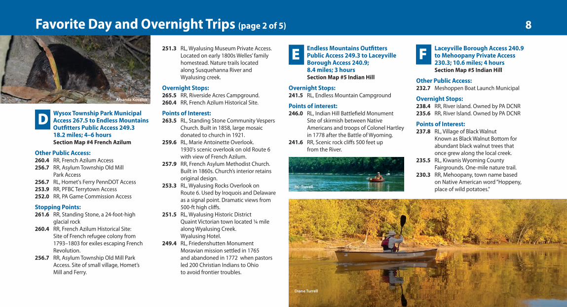
230.3 RR, Mehoopany, town name based on Native American word “Hoppeny,place of wild potatoes."
nD
nE nF
Amanda Kovalick
8Favorite Day and Overnight Trips (page 2 of 5)
Diane Turrell
RC Turrell
9feb21-20pg-12x13-cx2.qxp_Layout 1 2/10/21 3:11 PM Page 8
Mehoopany Private Access 230.3to Tunkhannock Riverside ParkMunicipal Access 218.5;11.8 miles; 4 hoursSection Map #6Vosburg Neck
Stopping Points:227.0 RL, North Branch Canal224.0 RL, Howland Preserve.
Prior permission only
Overnight Stops:229.2 River island. Owned by PA DCNR228.3 Two river islands. Owned by PA DCNR225.6 RL, Camp Lackawanna Private Access.
Prior permission only.
Points of Interest:229.9 RL, Procter and Gamble Paper Plant
Large paper-products plant, employing 2,300 people.
228.0 RL, Start of Vosburg Neck to mile 223, Long river meander flanked by scenic 500 foot high rock cliffs. Bald eagles commonly seen in area. Start of Vosburg 4000 foot long Lehigh ValleyRailroad tunnel.
223.0 RL, Howland Preserve Ownership: North Branch Land Trust. Over 2 miles of River frontage.(570) 310-1781
Tunkhannock Riverside ParkMunicipal Access 218.5 to PFBCApple Tree Access 201.7;16.8 miles; 5-6 hoursSection Map #7 Falls
Other Public Access:217.0 RR, PFBC Tunkhannock 211.3 RR, PFBC Whites Ferry 207.2 RR, PFBC West Falls
Overnight Stops:210.3 River island. Owned by Pa. DCNR206.6 Susquehanna Shores Campground
Point of interest:218.5 RL, Tunkhannock, name derived from
Native American word “Tonkhonink,” meaning “two small streams of waterfalling into one another” referring toTunkhannock Creek and Bowman'sCreek. Wyoming County Courthouse.National Register Historic District.
207.4 RL, Mouth of Buttermilk Creek. Paddle under the railroad bridge on RL to view lower waterfall.
PFBC Apple Tree Access 201.7 toNesbitt Park Municipal Access188.0; 13.7 miles; 4 – 5 hoursSection Map # 8 Pittston(UpperWyomingValley)
Stopping Point:195.5 RL, Pittston Riverfront Park
CAUTION: 196.8 Lower River levels expose apipe that crosses the River. It has sharp steelsticking out of the water that can damage aboat. Stay RL just past bridge.
Point of interest:198.0 RL, Campbell’s Ledge. Scenic sandstone
cliff, located .75 miles north ofconfluence of Susquehanna andLackawanna Rivers. Carved by glaciers;divides Wyoming and LackawannaValleys. Used by early settlers as asundial: the sun lights up the cliff face at approximately noon.
197.5 RR, Start of West Side Trail. 19-mile trail. 196.8 RL, Twin Shaft Disaster. Site of massive
cave-in at the Newton Coal Company'sTwin Shaft Colliery on June 28, 1896,killing 58 men.
195.6 RL, Pittston Riverfront Park. 8-acre riverfront area, walkways,artwork, and amphitheater.
195.5 RL, Start of Luzerne County Railwith Trail to river mile 189.7.11.6 mile trail to connect Pittstonand Wilkes-Barre.
194.5 RL, Knox Mine Disaster. In 1959 minersdug too close to the riverbed causingthe Susquehanna River to flood theanthracite mines killing 12 miners.This disaster ended undergroundmining in the Wyoming Valley.
193.4 RR, Queen Esther’s Bloody Rock Marker.Marks murder site of the 14 captiveAmerican soldiers by a local Indianwoman, traditionally identified as"Queen Esther" Montour, on the night ofJuly 3, 1778 after the Battle of Wyoming.
192.9 RR, Wyoming Monument.Commemorates Battle of Wyomingon July 3, 1778. 700 British, Tories, andSeneca Indians defeated 375 patriotsunder the command of Colonel ZebulonButler. Remains of the battle’s dead areburied in a mass grave belowmonument.
192.5 RR, Wyoming Valley Levee Trail,completed to river mile 187, Connectsto West Side Trail.
192.0 RR, Luzerne County Recreation Complex. Soccer fields, softball fields, picnicpavilions, and walking trails. Connectswith the Wyoming Valley Levee TrailSystem.
nG nH nI9Favorite Day and Overnight Trips (page 3 of 5)
Amanda Kovalick
22feb21-20pg-12x13-cx3.qxp_Layout 1 2/22/21 12:02 PM Page 9
Nesbitt Park Municipal Access188.3 to Canal Park MunicipalAccess 179.6; 8.7 miles; 3 hoursSection Map: # 9 Wilkes-Barre(Central Wyoming Valley)
Other Public Access:185.0 RL, PFBC Hanover Township
CAUTION: 180.0 Nanticoke Rapids: Class ll at certain river levels; stay right ofcenter, be cautious of boulders.
Points of interest:188.0 RL, City of Wilkes-Barre. Attractions
include the new River Commons Park,Lion Brewery, Luzerne CountyCourthouse, Luzerne County HistoricalSociety, F.M. Kirby Center, Kings College,and Wilkes University.
188.0 Black Diamond Trail, RL. A 10-mile stretch from Middleburg Road near White Haven to Route 437 justbelow Glen Summit in Mountain Top.
186.0 Susquehanna Warrior Trail168.0 RR. 18-mile trail located on former
Delaware, Lackawanna and Westernrailroad.
181.4 Avondale Mine Disaster, RR. Historic marker along Route 11 details catastrophic death of 110 men and boys who perished in 1869 mine fire.
180.5 Tilbury Knob, RL. Locally renowned sandstone rock outcrop. Legend has itthat a captive of a local Native Americantribe leapt from a cliff with his horse in the middle of the night, whileattempting to escape captors.
Canal Park Municipal Access 179.6to Shickshinny Municipal Access171.4; 8.2 miles; 3 hoursSection Map: #10 Nanticoke(Lower Wyoming Valley)
Other Public Access:178.3 RR, Hunlock Township Gardens 174.0 RR, PFBC Union
Point of interest:179.5 – 176.3
RR, Remnants of North Branch Canal.
Shickshinny Municipal Access171.4 to Test Track Park MunicipalAccess 158.4; 13.0 miles; 4–5 hoursSection Map #11 Council Cup
Other Public Access:166.3 RR, Wetlands Nature Area
CAUTION: 160.5 Nescopeck Falls.Very hazardous during low river levels (2 feet and lower at the Bloomsburggauge). Paddle close to right shore forsafest route.
Stopping Point:166.3 RR, Wetlands Nature Area Access
Points of Interest:171.0 RL, Mocanaqua Trail. A 9-mile system
with four trails. Ridgetop area hasseveral scenic overlooks. Trailheadlocated in Mocanaqua alongSusquehanna River.
167.4 RR, PPL/ Berwick Power Generating Plant166.9 RR, Susquehanna Riverlands
Environmental Preserve. Established in 1980. Encompasses 1,200 acres oneast and west banks of SusquehannaRiver. Jointly owned by Talen Energy and Allegheny Electric Cooperative, Inc.Provides year-round facilities for hiking,boating, fishing and attracts abundantwildlife. Connection to SusquehannaWarrior Trail.
161.5 RL, Nescopeck Borough. Known as Nescopeck Village; built on former siteof a Delaware Indian village.
160.1 RR, Berwick. Jackson Mansion:built by Civil War colonel, now borough offices.
nJ
nK
nL
Test Track Park Municipal Access158.4 to Bloomsburg Town ParkMunicipal Access 147.8;10.6 miles; 3 hoursSection Map #12 Bloomsburg
Other Public Access:155.9 RL, Mifflinville Municipal 154.4 RR, Columbia Park Municipal 150.0 RR, Espy Park Municipal 148.8 RR, PFBC Bloomsburg Access
Municipal park located on land used as an obstacle course to test militarytanks produced at Berwick American Car & Foundry plant during World War IIand the Korean War.
nM10Favorite Day and Overnight Trips (page 4 of 5)
Amanda Kovalick
9feb21-20pg-12x13-cx2.qxp_Layout 1 2/10/21 3:11 PM Page 10
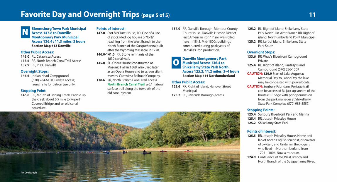
137.0 RR, Danville Borough. Montour CountyCourt House. Danville Historic District.First American iron "T" rail was rolledhere in 1845. Mid-1800s buildingsconstructed during peak years ofDanville’s iron production.
Danville Montgomery ParkMunicipal Access 136.4 toShikellamy State Park NorthAccess 125.2; 11.2 miles; 3–4 hoursSection Map #14 Northumberland
Other Public Access:125.6 RR, Right of island, Hanover Street
Municipal 125.2 RL, Riverside Borough Access
125.2 RL, Right of island, Shikellamy StatePark North. On West Branch RR, Right ofisland, Northumberland Point Municipal
125.2 RR, Left of island, Shikellamy StatePark South
Overnight Stops:133.6 RR, Wray's Riverfront Campground
Private 125.4 RL, Right of island, Fantasy Island
Campground (570) 286-1307CAUTION: 129.9 Start of Lake Augusta;
Memorial Day to Labor Day the lake may be congested with powerboats.
CAUTION: Sunbury Fabridam. Portage trail can be accessed RL just up stream of theRoute 61 Bridge with prior permissionfrom the park manager at ShikellamyState Park Complex, (570) 988-5557.
Stopping Points:125.4 Sunbury Riverfront Park and Marina125.4 RR, Joseph Priestley House125.2 Shikellamy State Park
Points of interest:125.5 RR, Joseph Priestley House. Home and
lab of noted English scientist, discovererof oxygen, and Unitarian theologian,who lived in Northumberland from 1794 – 1804. Now a museum.
124.9 Confluence of the West Branch and North Branch of the Susquehanna River.
nO
Bloomsburg Town Park MunicipalAccess 147.8 to DanvilleMontgomery Park MunicipalAccess 136.4 ; 11.3 miles; 3 hoursSection Map #13 Danville
Other Public Access:145.0 RL, Catawissa Access138.6 RR, North Branch Canal Trail Access137.9 RR, PFBC Danville
Overnight Stops:146.6 Indian Head Campground
(570) 784-6150. Private access;launch site for patron use only.
Stopping Point:146.6 RR, Mouth of Fishing Creek. Paddle up
the creek about 0.5 mile to RupertCovered Bridge and an old canalaqueduct.
nNPoints of interest:147.0 Fort McClure House, RR. One of a line
of stockaded log houses or ‘forts’reaching from the West Branch to theNorth Branch of the Susquehanna builtafter the Wyoming Massacre in 1778.
146.0-141.0 RR, Stone remnants of the1830 canal wall.
145.0 RL, Opera House; constructed asMasonic Hall in 1869, also used lateras an Opera House and to screen silentmovies. Catawissa Railroad Company.
138.6 RR, North Branch Canal Trail AccessNorth Branch Canal Trail; a 6.1 naturalsurface trail along the towpath of theold canal system.
11Favorite Day and Overnight Trips (page 5 of 5)
Art Coolbaugh
9feb21-20pg-12x13-cx2.qxp_Layout 1 2/10/21 3:11 PM Page 11
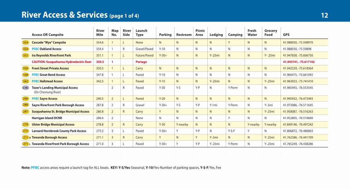
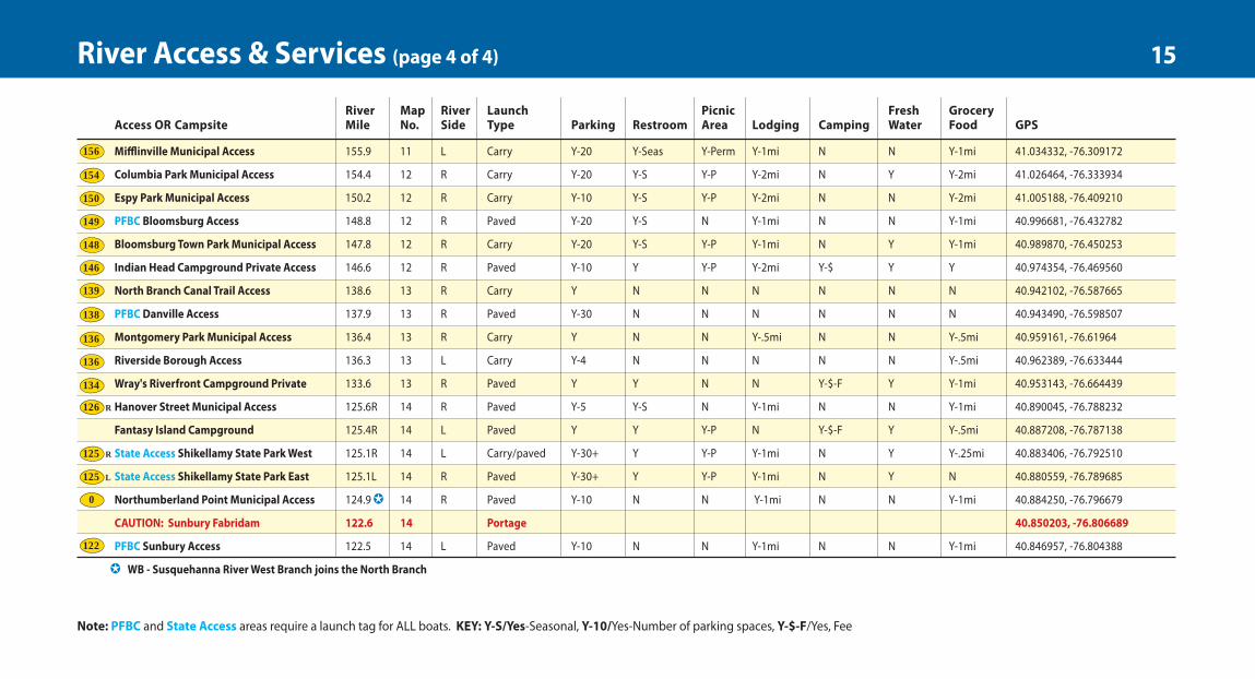
Note: PFBC access areas require a launch tag for ALL boats. KEY: Y-S/Yes-Seasonal, Y-10/Yes-Number of parking spaces, Y-$-F/Yes, Fee
River Map River Launch Picnic Fresh Grocery Access OR Campsite Mile No. Side Type Parking Restroom Area Lodging Camping Water Food GPS
Cascade “Wye” Campsite 354.6 1 L None N N N N Y N N 41.988030, -75.598970
PFBC Oakland Access 354.4 1 R Gravel/Paved Y-10 N N N N N N 41.988030, -75.59898
Ira Reynolds Riverfront Park 351.1 1 L Future/Paved Y-30+ N N Y-.25mi N N Y- .25mi 41.947838, -75.606750
CAUTION: Susquehanna Hydroelectric Dam 350.5 1 Portage 41.943741, -75.617102
Front Street Private Access 350.5 1 L Carry N N N N N N N 41.942529, -75.618364
PFBC Great Bend Access 347.8 1 L Paved Y-10 N N N N N N 41.960475, -75.661092
PFBC Hallstead Access 342.5 1 L Paved Y-15 N N Y-.25mi N N Y-.25mi 41.963023, -75.741410
Tozer's Landing Municipal Access 2 R Paved Y-30 Y-S Y-P N Y-Perm N N 41.985493, -76.553545 (On Chemung River)
PFBC Sayre Access 290.5 2 L Paved Y-20 N N N N N N 41.995932, -76.473493
Sayre Riverfront Park Borough Access 287.8 2 R Gravel Y-30+ Y-S Y-P Y-1mi Y-Perm N Y-.5mi 41.973086, -76.511645
Susquehanna St. Bridge Municipal Access 286.8 2 R Carry Y N N N N N Y-.25mi 41.958087, -76.516263
Harrigan Island DCNR 286.6 2 None N N N N Y N N 41.952805, -76.510660
Ulster Bridge Municipal Access 278.8 2 R Carry Y-30 Y-nearby N N N Y-nearby Y-nearby 41.849146, -76.497242
Larnard Hornbrook County Park Access 275.5 3 L Paved Y-30+ Y Y-P N Y-$-F Y N 41.806872, -76.486063
Towanda Borough Access 271.1 3 R Carry Y N Y Y-.5mi N N Y-.25mi 41.762386, -76.441709
Towanda Riverfront Park Borough Access 271.0 3 L Paved Y-30+ Y Y-P Y-.25mi Y-Perm N Y-.25mi 41.765249, -76.438286
River Map River Launch Picnic Fresh Grocery Mile No. Side Type Parking Restroom Area Lodging Camping Water Food GPS
268.6 3 L Gravel Y-20 N N N N N N 41.753570, -76.410521
3 L Paved Y-20 Y Y-Perm Y-.25mi N N Y-.25mi 41.767712, -76.397729
265.5 3 R Gravel Y Y Y-P Y Y-$-F Y N 41.761996, -76.376408
French Azilum Access 260.4 4 R Carry Y-30+ Y-S Y-P N Y-Perm-$-F Y N 41.738127, -76.309481
4 R Gravel Y-10 Y-S Y-P N N N N 41.698439, -76.329881
256.7 4 L Carry N N N N N N N 41.698152, -76.326212
253.9 4 R Gravel Y-20 Y-S N N N N N 41.694170, -76.281846
4 R Carry Y-5 N N N N N N 41.668076, -76.278744
249.3 4 R Carry Y-20 Y Y Y-.5mi Y-$-F Y N 41.641895, -76.237211
241.5 5 L Gravel Y Y Y-P N Y-$-F Y Y-2mi 41.638234, -76.174758
5 L Gravel Y-10 N Y N Y-Perm N Y-.25mi 41.643447, -76.163227
238.4 5 R None N N N N Y N N 41.616597, -76.137451
235.6 5 R None N N N N Y N N 41.609281, -76.110929
5 L Gravel/Paved Y-20 N N N N N Y-.25mi 41.610829, -76.049065
230.3 6 R Carry Y-5 Y Y N Y Y Y 41.576546, -76.060144
229.2 6 None N N N N Y N N 41.568467, -76.045572
228.3 6 None N N N N Y N N 41.564871, -76.028491
225.6 6 L Carry Y-20 Y Y-Perm Y Y-Perm-$-F Y N 41.533024, -76.033965
223.3 6 L Carry Y N Y-Perm N N N N 41.5495, -76.0070
River Map River Launch Picnic Fresh Grocery Access OR Campsite Mile No. Side Type Parking Restroom Area Lodging Camping Water Food GPS
218.5 6 L Paved Y-30 Y-Seas Y-Perm Y-.25mi Y-Perm N Y-.25mi 41.535222, -75.957458
217.0 6 R Paved Y-20 N N N N N Y-.25mi 41.522597, -75.940743
211.3 7 R Paved Y-10 Y-Seas N N N N N 41.477650, -75.905073
210.3 7 None N N N N Y N N 41.462767, -75.894696
2 7 R C Y Y Y N Y-Perm Y N 4
207.2 7 R Paved Y-20 N N N N N Y-.25 mi 41.459368, -75.853322
206.6 7 R Paved Y Y N N Y-$-F Y N 41.452319, -75.854259
201.7 7 R Paved Y-20 N N N N Y-nearby Y-nearby 41.388328, -75.823568
1 8 L Carry Y-10+ N Y N N Y-.5 mi Y-.5 mi 41.2911, -75.8518
1 9 L Gravel Y N Y Y-.25mi N Y-.25mi Y-.25mi 41.2497, -75.8830
188.3 9 R Paved Y-30+ N Y-Perm Y-.5 mi N N Y-.5 mi 41.250975, -75.884735
PFBC 185.0 9 L Paved Y-30+ N N N N N Y-1 41.237129, -75.938106
178.3 10 R Paved Y-10 Y N N N N N 41.212057, -76.042414
174.0 10 R Paved Y-30+ Y N N N N N 41.178963, -76.106207
171.4 10 R Paved Y Y N N Y N Y-.5 mi 41.152032, -76.147240
166.3 11 R Carry Y-10 N Y N N N N 41.090993, -76.131286
1 11 L Paved Y-10 Y-Seas N N N Y-.5 mi 4
158.4 11 R Paved Y-20 Y-Seas Y Y-1mi Y-P N Y-1mi 41.040126, -76.260558
River Map River Launch Picnic Fresh Grocery Mile No. Side Type Parking Restroom Area Lodging Camping Water Food GPS
155.9 11 L Carry Y-20 Y-Seas Y-Perm Y-1mi N N Y-1mi 41.034332, -76.309172
154.4 12 R Carry Y-20 Y-S Y-P Y-2mi N Y Y-2mi 41.026464, -76.333934
150.2 12 R Carry Y-10 Y-S Y-P Y-2mi N N Y-2mi 41.005188, -76.409210
148.8 12 R Paved Y-20 Y-S N Y-1mi N N Y-1mi 40.996681, -76.432782
147.8 12 R Carry Y-20 Y-S Y-P Y-1mi N Y Y-1mi 40.989870, -76.450253
146.6 12 R Paved Y-10 Y Y-P Y-2mi Y-$ Y Y 40.974354, -76.469560
138.6 13 R Carry Y N N N N N N 40.942102, -76.587665
137.9 13 R Paved Y-30 N N N N N N 40.943490, -76.598507
136.4 13 R Carry Y N N Y-.5mi N N Y-.5mi 40.959161, -76.61964
1 13 L Carry Y-4 N N N N N Y-.5mi 40.962389, -76.633444
133.6 13 R Paved Y Y N N Y-$-F Y Y-1mi 40.953143, -76.664439
125.6R 14 R Paved Y-5 Y-S N Y-1mi N N Y-1mi 40.890045, -76.788232
125.4R 14 L Paved Y Y Y-P N Y-$-F Y Y-.5mi 40.887208, -76.787138
125.1R 14 L Carry/paved Y-30+ Y Y-P Y-1mi N Y Y-.25mi 40.883406, -76.792510
125.1L 14 R Paved Y-30+ Y Y-P Y-1mi N Y N 40.880559, -76.789685
124.9 14 R Paved Y-10 N N Y-1mi N N Y-1mi 40.884250, -76.796679
122.6 14 Portage 40.850203, -76.806689
122.5 14 L Paved Y-10 N N Y-1mi N N Y-1mi 40.846957, -76.804388
l354
l354
l351
l350
l348
l342
l290
l288
l287
l279
l275
l271 R
l271 L
R
L
lCHE
12River Access & Services (page 1 of 4)
9feb21-20pg-12x13-cx2.qxp_Layout 1 2/10/21 3:11 PM Page 12
River Map River Launch Picnic Fresh Grocery Mile No. Side Type Parking Restroom Area Lodging Camping Water Food GPS
354.6 1 L None N N N N Y N N 41.988030, -75.598970
354.4 1 R Gravel/Paved Y-10 N N N N N N 41.988030, -75.59898
351.1 1 L Future/Paved Y-30+ N N Y-.25mi N N Y- .25mi 41.947838, -75.606750
1 Portage 41.943741, -75.617102
350.5 1 L Carry N N N N N N N 41.942529, -75.618364
347.8 1 L Paved Y-10 N N N N N N 41.960475, -75.661092
342.5 1 L Paved Y-15 N N Y-.25mi N N Y-.25mi 41.963023, -75.741410
2 R Paved Y-30 Y-S Y-P N Y-Perm N N 41.985493, -76.553545
290.5 2 L Paved Y-20 N N N N N N 41.995932, -76.473493
287.8 2 R Gravel Y-30+ Y-S Y-P Y-1mi Y-Perm N Y-.5mi 41.973086, -76.511645
286.8 2 R Carry Y N N N N N Y-.25mi 41.958087, -76.516263
286.6 2 None N N N N Y N N 41.952805, -76.510660
278.8 2 R Carry Y-30 Y-nearby N N N Y-nearby Y-nearby 41.849146, -76.497242
275.5 3 L Paved Y-30+ Y Y-P N Y-$-F Y N 41.806872, -76.486063
271.1 3 R Carry Y N Y Y-.5mi N N Y-.25mi 41.762386, -76.441709
271.0 3 L Paved Y-30+ Y Y-P Y-.25mi Y-Perm N Y-.25mi 41.765249, -76.438286
River Map River Launch Picnic Fresh Grocery Access OR Campsite Mile No. Side Type Parking Restroom Area Lodging Camping Water Food GPS
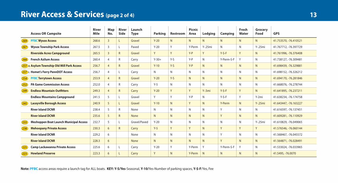
PFBCWysox Access 268.6 3 L Gravel Y-20 N N N N N N 41.753570, -76.410521
Wysox Township Park Access 267.5 3 L Paved Y-20 Y Y-Perm Y-.25mi N N Y-.25mi 41.767712, -76.397729
Riverside Acres Campground 265.5 3 R Gravel Y Y Y-P Y Y-$-F Y N 41.761996, -76.376408
French Azilum Access 260.4 4 R Carry Y-30+ Y-S Y-P N Y-Perm-$-F Y N 41.738127, -76.309481
Asylum Township Old Mill Park Access 256.7 4 R Gravel Y-10 Y-S Y-P N N N N 41.698439, -76.329881
Homet's Ferry PennDOT Access 256.7 4 L Carry N N N N N N N 41.698152, -76.326212
PFBC Terrytown Access 253.9 4 R Gravel Y-20 Y-S N N N N N 41.694170, -76.281846
PA Game Commission Access 252.0 4 R Carry Y-5 N N N N N N 41.668076, -76.278744
Endless Mountain OutAtters 249.3 4 R Carry Y-20 Y Y Y-.5mi Y-$-F Y N 41.641895, -76.237211
Endless Mountains Campground 241.5 5 L Gravel Y Y Y-P N Y-$-F Y Y-2mi 41.638234, -76.174758
Laceyville Borough Access 240.9 5 L Gravel Y-10 N Y N Y-Perm N Y-.25mi 41.643447, -76.163227
River Island DCNR 238.4 5 R None N N N N Y N N 41.616597, -76.137451
River Island DCNR 235.6 5 R None N N N N Y N N 41.609281, -76.110929
Meshoppen Boat Launch Municipal Access 232.7 5 L Gravel/Paved Y-20 N N N N N Y-.25mi 41.610829, -76.049065
Mehoopany Private Access 230.3 6 R Carry Y-5 Y Y N Y Y Y 41.576546, -76.060144
River Island DCNR 229.2 6 None N N N N Y N N 41.568467, -76.045572
River Island DCNR 228.3 6 None N N N N Y N N 41.564871, -76.028491
Camp Lackawanna Private Access 225.6 6 L Carry Y-20 Y Y-Perm Y Y-Perm-$-F Y N 41.533024, -76.033965
Howland Preserve 223.3 6 L Carry Y N Y-Perm N N N N 41.5495, -76.0070
River Map River Launch Picnic Fresh Grocery Access OR Campsite Mile No. Side Type Parking Restroom Area Lodging Camping Water Food GPS
6 L Paved Y-30 Y-Seas Y-Perm Y-.25mi Y-Perm N Y-.25mi 41.535222, -75.957458
217.0 6 R Paved Y-20 N N N N N Y-.25mi 41.522597, -75.940743
211.3 7 R Paved Y-10 Y-Seas N N N N N 41.477650, -75.905073
210.3 7 None N N N N Y N N 41.462767, -75.894696
2 7 R C Y Y Y N Y-Perm Y N 4
207.2 7 R Paved Y-20 N N N N N Y-.25 mi 41.459368, -75.853322
206.6 7 R Paved Y Y N N Y-$-F Y N 41.452319, -75.854259
7 R Paved Y-20 N N N N Y-nearby Y-nearby 41.388328, -75.823568
1 8 L Carry Y-10+ N Y N N Y-.5 mi Y-.5 mi 41.2911, -75.8518
1 9 L Gravel Y N Y Y-.25mi N Y-.25mi Y-.25mi 41.2497, -75.8830
188.3 9 R Paved Y-30+ N Y-Perm Y-.5 mi N N Y-.5 mi 41.250975, -75.884735
PFBC 185.0 9 L Paved Y-30+ N N N N N Y-1 41.237129, -75.938106
10 R Paved Y-10 Y N N N N N 41.212057, -76.042414
174.0 10 R Paved Y-30+ Y N N N N N 41.178963, -76.106207
171.4 10 R Paved Y Y N N Y N Y-.5 mi 41.152032, -76.147240
11 R Carry Y-10 N Y N N N N 41.090993, -76.131286
1 11 L Paved Y-10 Y-Seas N N N Y-.5 mi 4
158.4 11 R Paved Y-20 Y-Seas Y Y-1mi Y-P N Y-1mi 41.040126, -76.260558
River Map River Launch Picnic Fresh Grocery Mile No. Side Type Parking Restroom Area Lodging Camping Water Food GPS
155.9 11 L Carry Y-20 Y-Seas Y-Perm Y-1mi N N Y-1mi 41.034332, -76.309172
154.4 12 R Carry Y-20 Y-S Y-P Y-2mi N Y Y-2mi 41.026464, -76.333934
150.2 12 R Carry Y-10 Y-S Y-P Y-2mi N N Y-2mi 41.005188, -76.409210
148.8 12 R Paved Y-20 Y-S N Y-1mi N N Y-1mi 40.996681, -76.432782
12 R Carry Y-20 Y-S Y-P Y-1mi N Y Y-1mi 40.989870, -76.450253
12 R Paved Y-10 Y Y-P Y-2mi Y-$ Y Y 40.974354, -76.469560
138.6 13 R Carry Y N N N N N N 40.942102, -76.587665
137.9 13 R Paved Y-30 N N N N N N 40.943490, -76.598507
136.4 13 R Carry Y N N Y-.5mi N N Y-.5mi 40.959161, -76.61964
1 13 L Carry Y-4 N N N N N Y-.5mi 40.962389, -76.633444
133.6 13 R Paved Y Y N N Y-$-F Y Y-1mi 40.953143, -76.664439
125.6R 14 R Paved Y-5 Y-S N Y-1mi N N Y-1mi 40.890045, -76.788232
125.4R 14 L Paved Y Y Y-P N Y-$-F Y Y-.5mi 40.887208, -76.787138
125.1R 14 L Carry/paved Y-30+ Y Y-P Y-1mi N Y Y-.25mi 40.883406, -76.792510
125.1L 14 R Paved Y-30+ Y Y-P Y-1mi N Y N 40.880559, -76.789685
124.9 14 R Paved Y-10 N N Y-1mi N N Y-1mi 40.884250, -76.796679
122.6 14 Portage 40.850203, -76.806689
122.5 14 L Paved Y-10 N N Y-1mi N N Y-1mi 40.846957, -76.804388
l269
l267
l260
l257 R
l257 L
l254
l252
l249
l241
l233
l230
l225
l223
R
Note: PFBC access areas require a launch tag for ALL boats. KEY: Y-S/Yes-Seasonal, Y-10/Yes-Number of parking spaces, Y-$-F/Yes, Fee
13River Access & Services (page 2 of 4)
9feb21-20pg-12x13-cx2.qxp_Layout 1 2/10/21 3:11 PM Page 13
River Map River Launch Picnic Fresh Grocery Mile No. Side Type Parking Restroom Area Lodging Camping Water Food GPS
354.6 1 L None N N N N Y N N 41.988030, -75.598970
354.4 1 R Gravel/Paved Y-10 N N N N N N 41.988030, -75.59898
351.1 1 L Future/Paved Y-30+ N N Y-.25mi N N Y- .25mi 41.947838, -75.606750
1 Portage 41.943741, -75.617102
350.5 1 L Carry N N N N N N N 41.942529, -75.618364
347.8 1 L Paved Y-10 N N N N N N 41.960475, -75.661092
342.5 1 L Paved Y-15 N N Y-.25mi N N Y-.25mi 41.963023, -75.741410
2 R Paved Y-30 Y-S Y-P N Y-Perm N N 41.985493, -76.553545
290.5 2 L Paved Y-20 N N N N N N 41.995932, -76.473493
287.8 2 R Gravel Y-30+ Y-S Y-P Y-1mi Y-Perm N Y-.5mi 41.973086, -76.511645
286.8 2 R Carry Y N N N N N Y-.25mi 41.958087, -76.516263
286.6 2 None N N N N Y N N 41.952805, -76.510660
278.8 2 R Carry Y-30 Y-nearby N N N Y-nearby Y-nearby 41.849146, -76.497242
275.5 3 L Paved Y-30+ Y Y-P N Y-$-F Y N 41.806872, -76.486063
271.1 3 R Carry Y N Y Y-.5mi N N Y-.25mi 41.762386, -76.441709
271.0 3 L Paved Y-30+ Y Y-P Y-.25mi Y-Perm N Y-.25mi 41.765249, -76.438286
River Map River Launch Picnic Fresh Grocery Mile No. Side Type Parking Restroom Area Lodging Camping Water Food GPS
268.6 3 L Gravel Y-20 N N N N N N 41.753570, -76.410521
267.5 3 L Paved Y-20 Y Y-Perm Y-.25mi N N Y-.25mi 41.767712, -76.397729
265.5 3 R Gravel Y Y Y-P Y Y-$-F Y N 41.761996, -76.376408
French Azilum Access 260.4 4 R Carry Y-30+ Y-S Y-P N Y-Perm-$-F Y N 41.738127, -76.309481
256.7 4 R Gravel Y-10 Y-S Y-P N N N N 41.698439, -76.329881
256.7 4 L Carry N N N N N N N 41.698152, -76.326212
253.9 4 R Gravel Y-20 Y-S N N N N N 41.694170, -76.281846
252.0 4 R Carry Y-5 N N N N N N 41.668076, -76.278744
249.3 4 R Carry Y-20 Y Y Y-.5mi Y-$-F Y N 41.641895, -76.237211
241.5 5 L Gravel Y Y Y-P N Y-$-F Y Y-2mi 41.638234, -76.174758
240.9 5 L Gravel Y-10 N Y N Y-Perm N Y-.25mi 41.643447, -76.163227
238.4 5 R None N N N N Y N N 41.616597, -76.137451
235.6 5 R None N N N N Y N N 41.609281, -76.110929
232.7 5 L Gravel/Paved Y-20 N N N N N Y-.25mi 41.610829, -76.049065
230.3 6 R Carry Y-5 Y Y N Y Y Y 41.576546, -76.060144
229.2 6 None N N N N Y N N 41.568467, -76.045572
228.3 6 None N N N N Y N N 41.564871, -76.028491
225.6 6 L Carry Y-20 Y Y-Perm Y Y-Perm-$-F Y N 41.533024, -76.033965
223.3 6 L Carry Y N Y-Perm N N N N 41.5495, -76.0070
River Map River Launch Picnic Fresh Grocery Access OR Campsite Mile No. Side Type Parking Restroom Area Lodging Camping Water Food GPS
Tunkhannock Riverside Park Boro. Access 218.5 6 L Paved Y-30 Y-Seas Y-Perm Y-.25mi Y-Perm N Y-.25mi 41.535222, -75.957458
PFBC Tunkhannock Access 217.0 6 R Paved Y-20 N N N N N Y-.25mi 41.522597, -75.940743
PFBCWhites Ferry Access 211.3 7 R Paved Y-10 Y-Seas N N N N N 41.477650, -75.905073
River Island DCNR 210.3 7 None N N N N Y N N 41.462767, -75.894696
Falls Township Municipal Access 207.6 7 R Carry Y Y Y N Y-Perm Y N 41.462273, -75.857034
PFBCWest Falls Access 207.2 7 R Paved Y-20 N N N N N Y-.25 mi 41.459368, -75.853322
Susquehanna Shores Campground 206.6 7 R Paved Y Y N N Y-$-F Y N 41.452319, -75.854259
PFBC Apple Tree Road Access 201.7 7 R Paved Y-20 N N N N Y-nearby Y-nearby 41.388328, -75.823568
Plains Township 192 8 L Carry Y-10+ N Y N N Y-.5 mi Y-.5 mi 41.2911, -75.8518
River Common Park Access 188.3 9 L Gravel Y N Y Y-.25mi N Y-.25mi Y-.25mi 41.2497, -75.8830
Nesbitt Park Municipal Access 188.3 9 R Paved Y-30+ N Y-Perm Y-.5 mi N N Y-.5 mi 41.250975, -75.884735
PFBC Hanover Township Access 185.0 9 L Paved Y-30+ N N N N N Y-1 41.237129, -75.938106
Hunlock Township Gardens Access 178.3 10 R Paved Y-10 Y N N N N N 41.212057, -76.042414
PFBC Union Access 174.0 10 R Paved Y-30+ Y N N N N N 41.178963, -76.106207
Shickshinny Municipal Access 171.4 10 R Paved Y Y N N Y N Y-.5 mi 41.152032, -76.147240
Wetlands Nature Area Access 166.3 11 R Carry Y-10 N Y N N N N 41.090993, -76.131286
Nescopeck VFW Launch 165.4 11 L Paved Y-10 Y-Seas N N N Y-.5 mi 41.069187, -76.140346
Test Track Park Municipal Access 158.4 11 R Paved Y-20 Y-Seas Y Y-1mi Y-P N Y-1mi 41.040126, -76.260558
River Map River Launch Picnic Fresh Grocery Mile No. Side Type Parking Restroom Area Lodging Camping Water Food GPS
11 L Carry Y-20 Y-Seas Y-Perm Y-1mi N N Y-1mi 41.034332, -76.309172
12 R Carry Y-20 Y-S Y-P Y-2mi N Y Y-2mi 41.026464, -76.333934
150.2 12 R Carry Y-10 Y-S Y-P Y-2mi N N Y-2mi 41.005188, -76.409210
148.8 12 R Paved Y-20 Y-S N Y-1mi N N Y-1mi 40.996681, -76.432782
12 R Carry Y-20 Y-S Y-P Y-1mi N Y Y-1mi 40.989870, -76.450253
12 R Paved Y-10 Y Y-P Y-2mi Y-$ Y Y 40.974354, -76.469560
13 R Carry Y N N N N N N 40.942102, -76.587665
137.9 13 R Paved Y-30 N N N N N N 40.943490, -76.598507
136.4 13 R Carry Y N N Y-.5mi N N Y-.5mi 40.959161, -76.61964
13 L Carry Y-4 N N N N N Y-.5mi 40.962389, -76.633444
13 R Paved Y Y N N Y-$-F Y Y-1mi 40.953143, -76.664439
125.6R 14 R Paved Y-5 Y-S N Y-1mi N N Y-1mi 40.890045, -76.788232
125.4R 14 L Paved Y Y Y-P N Y-$-F Y Y-.5mi 40.887208, -76.787138
Carry/paved Y-30+ Y Y-P Y-1mi N Y Y-.25mi 40.883406, -76.792510
125.1L 14 R Paved Y-30+ Y Y-P Y-1mi N Y N 40.880559, -76.789685
124.9 14 R Paved Y-10 N N Y-1mi N N Y-1mi 40.884250, -76.796679
122.6 14 Portage 40.850203, -76.806689
122.5 14 L Paved Y-10 N N Y-1mi N N Y-1mi 40.846957, -76.804388
l219
l217
l211
l208
l207
l202
l192
l188
l188
l185
l178
l171l174
l165l166
l158
R
L
R
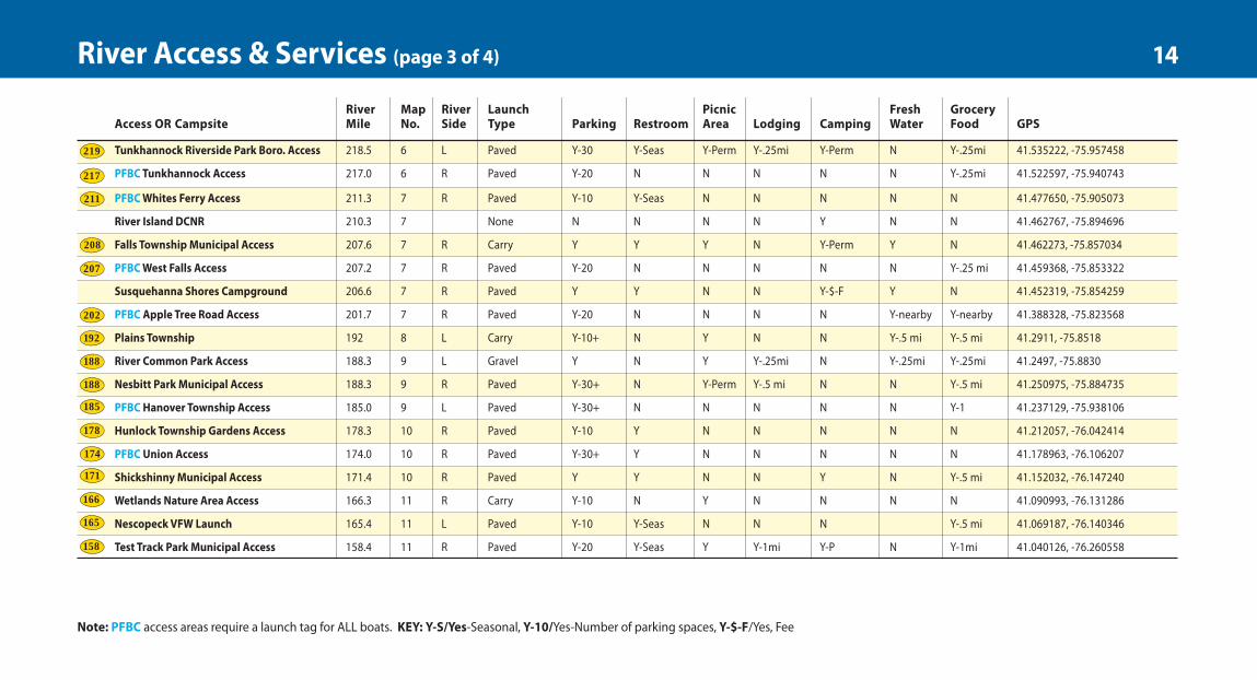
Note: PFBC access areas require a launch tag for ALL boats. KEY: Y-S/Yes-Seasonal, Y-10/Yes-Number of parking spaces, Y-$-F/Yes, Fee
14River Access & Services (page 3 of 4)
9feb21-20pg-12x13-cx2.qxp_Layout 1 2/10/21 3:11 PM Page 14
River Map River Launch Picnic Fresh Grocery Mile No. Side Type Parking Restroom Area Lodging Camping Water Food GPS
354.6 1 L None N N N N Y N N 41.988030, -75.598970
354.4 1 R Gravel/Paved Y-10 N N N N N N 41.988030, -75.59898
351.1 1 L Future/Paved Y-30+ N N Y-.25mi N N Y- .25mi 41.947838, -75.606750
1 Portage 41.943741, -75.617102
350.5 1 L Carry N N N N N N N 41.942529, -75.618364
347.8 1 L Paved Y-10 N N N N N N 41.960475, -75.661092
342.5 1 L Paved Y-15 N N Y-.25mi N N Y-.25mi 41.963023, -75.741410
2 R Paved Y-30 Y-S Y-P N Y-Perm N N 41.985493, -76.553545
290.5 2 L Paved Y-20 N N N N N N 41.995932, -76.473493
287.8 2 R Gravel Y-30+ Y-S Y-P Y-1mi Y-Perm N Y-.5mi 41.973086, -76.511645
286.8 2 R Carry Y N N N N N Y-.25mi 41.958087, -76.516263
286.6 2 None N N N N Y N N 41.952805, -76.510660
278.8 2 R Carry Y-30 Y-nearby N N N Y-nearby Y-nearby 41.849146, -76.497242
275.5 3 L Paved Y-30+ Y Y-P N Y-$-F Y N 41.806872, -76.486063
271.1 3 R Carry Y N Y Y-.5mi N N Y-.25mi 41.762386, -76.441709
271.0 3 L Paved Y-30+ Y Y-P Y-.25mi Y-Perm N Y-.25mi 41.765249, -76.438286
River Map River Launch Picnic Fresh Grocery Mile No. Side Type Parking Restroom Area Lodging Camping Water Food GPS
268.6 3 L Gravel Y-20 N N N N N N 41.753570, -76.410521
267.5 3 L Paved Y-20 Y Y-Perm Y-.25mi N N Y-.25mi 41.767712, -76.397729
265.5 3 R Gravel Y Y Y-P Y Y-$-F Y N 41.761996, -76.376408
French Azilum Access 260.4 4 R Carry Y-30+ Y-S Y-P N Y-Perm-$-F Y N 41.738127, -76.309481
256.7 4 R Gravel Y-10 Y-S Y-P N N N N 41.698439, -76.329881
256.7 4 L Carry N N N N N N N 41.698152, -76.326212
253.9 4 R Gravel Y-20 Y-S N N N N N 41.694170, -76.281846
252.0 4 R Carry Y-5 N N N N N N 41.668076, -76.278744
249.3 4 R Carry Y-20 Y Y Y-.5mi Y-$-F Y N 41.641895, -76.237211
241.5 5 L Gravel Y Y Y-P N Y-$-F Y Y-2mi 41.638234, -76.174758
240.9 5 L Gravel Y-10 N Y N Y-Perm N Y-.25mi 41.643447, -76.163227
238.4 5 R None N N N N Y N N 41.616597, -76.137451
235.6 5 R None N N N N Y N N 41.609281, -76.110929
232.7 5 L Gravel/Paved Y-20 N N N N N Y-.25mi 41.610829, -76.049065
230.3 6 R Carry Y-5 Y Y N Y Y Y 41.576546, -76.060144
229.2 6 None N N N N Y N N 41.568467, -76.045572
228.3 6 None N N N N Y N N 41.564871, -76.028491
225.6 6 L Carry Y-20 Y Y-Perm Y Y-Perm-$-F Y N 41.533024, -76.033965
223.3 6 L Carry Y N Y-Perm N N N N 41.5495, -76.0070
River Map River Launch Picnic Fresh Grocery Access OR Campsite Mile No. Side Type Parking Restroom Area Lodging Camping Water Food GPS
218.5 6 L Paved Y-30 Y-Seas Y-Perm Y-.25mi Y-Perm N Y-.25mi 41.535222, -75.957458
217.0 6 R Paved Y-20 N N N N N Y-.25mi 41.522597, -75.940743
211.3 7 R Paved Y-10 Y-Seas N N N N N 41.477650, -75.905073
210.3 7 None N N N N Y N N 41.462767, -75.894696
2 7 R C Y Y Y N Y-Perm Y N 4
207.2 7 R Paved Y-20 N N N N N Y-.25 mi 41.459368, -75.853322
206.6 7 R Paved Y Y N N Y-$-F Y N 41.452319, -75.854259
201.7 7 R Paved Y-20 N N N N Y-nearby Y-nearby 41.388328, -75.823568
1 8 L Carry Y-10+ N Y N N Y-.5 mi Y-.5 mi 41.2911, -75.8518
1 9 L Gravel Y N Y Y-.25mi N Y-.25mi Y-.25mi 41.2497, -75.8830
188.3 9 R Paved Y-30+ N Y-Perm Y-.5 mi N N Y-.5 mi 41.250975, -75.884735
PFBC 185.0 9 L Paved Y-30+ N N N N N Y-1 41.237129, -75.938106
178.3 10 R Paved Y-10 Y N N N N N 41.212057, -76.042414
174.0 10 R Paved Y-30+ Y N N N N N 41.178963, -76.106207
171.4 10 R Paved Y Y N N Y N Y-.5 mi 41.152032, -76.147240
166.3 11 R Carry Y-10 N Y N N N N 41.090993, -76.131286
1 11 L Paved Y-10 Y-Seas N N N Y-.5 mi 4
158.4 11 R Paved Y-20 Y-Seas Y Y-1mi Y-P N Y-1mi 41.040126, -76.260558
River Map River Launch Picnic Fresh Grocery Access OR Campsite Mile No. Side Type Parking Restroom Area Lodging Camping Water Food GPS
Mi@inville Municipal Access 155.9 11 L Carry Y-20 Y-Seas Y-Perm Y-1mi N N Y-1mi 41.034332, -76.309172
Columbia Park Municipal Access 154.4 12 R Carry Y-20 Y-S Y-P Y-2mi N Y Y-2mi 41.026464, -76.333934
Espy Park Municipal Access 150.2 12 R Carry Y-10 Y-S Y-P Y-2mi N N Y-2mi 41.005188, -76.409210
PFBC Bloomsburg Access 148.8 12 R Paved Y-20 Y-S N Y-1mi N N Y-1mi 40.996681, -76.432782
Bloomsburg Town Park Municipal Access 147.8 12 R Carry Y-20 Y-S Y-P Y-1mi N Y Y-1mi 40.989870, -76.450253
Indian Head Campground Private Access 146.6 12 R Paved Y-10 Y Y-P Y-2mi Y-$ Y Y 40.974354, -76.469560
North Branch Canal Trail Access 138.6 13 R Carry Y N N N N N N 40.942102, -76.587665
PFBC Danville Access 137.9 13 R Paved Y-30 N N N N N N 40.943490, -76.598507
Montgomery Park Municipal Access 136.4 13 R Carry Y N N Y-.5mi N N Y-.5mi 40.959161, -76.61964
Riverside Borough Access 136.3 13 L Carry Y-4 N N N N N Y-.5mi 40.962389, -76.633444
Wray's Riverfront Campground Private 133.6 13 R Paved Y Y N N Y-$-F Y Y-1mi 40.953143, -76.664439
Hanover Street Municipal Access 125.6R 14 R Paved Y-5 Y-S N Y-1mi N N Y-1mi 40.890045, -76.788232
Fantasy Island Campground 125.4R 14 L Paved Y Y Y-P N Y-$-F Y Y-.5mi 40.887208, -76.787138
State Access Shikellamy State Park West 125.1R 14 L Carry/paved Y-30+ Y Y-P Y-1mi N Y Y-.25mi 40.883406, -76.792510
State Access Shikellamy State Park East 125.1L 14 R Paved Y-30+ Y Y-P Y-1mi N Y N 40.880559, -76.789685
Northumberland Point Municipal Access 124.9G 14 R Paved Y-10 N N Y-1mi N N Y-1mi 40.884250, -76.796679
CAUTION: Sunbury Fabridam 122.6 14 Portage 40.850203, -76.806689
PFBC Sunbury Access 122.5 14 L Paved Y-10 N N Y-1mi N N Y-1mi 40.846957, -76.804388
G WB - Susquehanna River West Branch joins the North Branch
l156
l154
l150
l149
l148
l146
l139
l138
l136
l136
l134
l125 R
l125 L
l122
l0
l126 R
Note: PFBC and State Access areas require a launch tag for ALL boats. KEY: Y-S/Yes-Seasonal, Y-10/Yes-Number of parking spaces, Y-$-F/Yes, Fee
15River Access & Services (page 4 of 4)
9feb21-20pg-12x13-cx2.qxp_Layout 1 2/10/21 3:11 PM Page 15
EndlessMountainsHeritage Regionemheritage.org
The EMHR is a non-profit organization created in 1998 under the Heritage AreasProgram administered by the Department of Conservation and Natural Resources. Our region covers Susquehanna, Bradford,Wyoming and Sullivan counties and it containsa multitude of scenic, natural, historic andrecreational resources that collectivelyexemplify the rural agricultural heritage of Pennsylvania. Since 1998, the EMHR hasfunded numerous projects with partnerorganizations, all oriented to increasing thequality of life for residents and visitors.
emheritage.org602 Main St., Suite 7Towanda, PA 18848(570) 265-1528
Executive Director: Cain [email protected]
Administrative Assistant:Vanessa [email protected]
Water Trails inPennsylvaniaThe Susquehanna RiverWater Trail – North Branchis part of the PennsylvaniaWater Trail System and theprogram is coordinated
by Pennsylvania Environmental Council (PEC)with funding support from DCNR. At Sunbury,the water trail connects with two other routes -the Susquehanna River Water Trail’s MiddleSection and West Branch.
For more on Pennsylvania water trails visit:pawatertrails.org
SusquehannaGreenway PartnershipThe Susquehanna GreenwayPartnership is dedicated todeveloping and sustaining the Susquehanna Greenway to connect communities and
enrich lives through enhanced recreation,healthy living, economic prosperity andenvironmental stewardship. The Partnershipguides planning for the Susquehanna Greenwayand fosters community action to establish theGreenway. Establishment of the Greenway is a farsighted undertaking shaped by regionalvalues and an over-arching vision, extendingnearly 500 miles through 22 Pennsylvaniacounties. Greenway plans and designs arebased on consideration of existing, currentlyplanned, and newly proposed projects andideas identified through public involvement.Please join us in creating the SusquehannaGreenway!
Department of Conservation and Natural ResourcesEstablished on July 1, 1995, the PennsylvaniaDepartment of Conservation and NaturalResources (DCNR) was established with amission to conserve and sustain Pennsylvania’snatural resources for present and futuregenerations’ use and enjoyment. The agencyis responsible for maintaining and protectingover 120 state parks, managing 2.2 million acresof state forest land, providing information onthe state's ecological and geologic resources,and establishing community conservationpartnerships with grants and technicalassistance to benefit rivers, trails, greenways,local parks and recreation, regional heritageparks, open space, and natural areas. The DCNRis also charged with designating and overseeingthe 12 Pennsylvania Heritage Areas.
dcnr.pa.gov
Susquehanna North Branch Water Trail Resources 16
RC Turrell
9feb21-20pg-12x13-cx2.qxp_Layout 1 2/10/21 3:11 PM Page 16
Water Trail ManagersSections 1 through 10Endless Mountains Heritage Region
emheritage.org (570) 265-1528
Sections 11 through 14Susquehanna Greenway Partnership susquehannagreenway.org (570) 478-0178
Section 1 through 7
Endless Mountains Heritage RegionTowanda emheritage.org (570) 265-1528
Endless Mountains Visitors Bureau Tunkhannock endlessmountains.org (800) 769-8999
Section 2 (Sayre, Athens)
Greater Valley Chamber of CommerceSayre (570) 888-2217
Section 3, 4 (Towanda, Wysox)
Central Bradford Co. Chamber of CommerceTowanda towandawysox.com (570) 268-2732
Information for Lodging, Businesses & Attractions
Pennsylvania State Parks dcnr.state.pa.us/StateParks
Salt Springs State Park (570) 967-7275Mt. Pisgah State Park (570) 297-2734Lackawanna State Park (570) 945-3239Frances Slocum State Park (570) 696-3525Nescopeck State Park (570) 403-2006Shikellamy State Park (570) 988-5557
State AgenciesPennsylvania Fish & Boat Commission (PFBC)
fishandboat.com (888) 723-4741
Pennsylvania Game Commission pgc.state.pa.us (717) 787-4250
Pennsylvania State Parks & Forests dcnr.state.pa.us (717) 787-2869
Section 5 (Wyalusing)
Greater Wyalusing Chamber of CommerceWyalusing wyalusing.net (570) 746-4922
Section 6, 7 (Tunkhannock, West Falls)
Wyoming County Chamber of CommerceTunkhannock wyccc.com (570) 836-7755
Sections 8, 9, 10 (Pittston, Wilkes-Barre, Shickshinny)
Lackawanna County Convention & Visitors Bureau
visitnepa.org (800) 229-3526
Visit Luzerne County Tourism Agencyvisitluzernecounty.com (570) 819-1877
Greater Pittston Chamber of CommercePittston pittstonchamber.org (570) 655-1424
Greater Wyoming Valley Chamber of Commerce
City of Wilkes-Barre wyomingvalleychamber.org (570) 823-2101
Sections 11, 12, 13(Berwick, Bloomsburg, Catawissa, Danville)
Berwick Area Chamber of CommerceBerwick berwickpa.org (570) 752-3601
Columbia-Montour Chamber of Commerce Bloomsburg (570) 784-2522 columbiamontourchamber.com
Columbia-Montour Visitors BureauBloomsburg (570) 784-8279itourcolumbiamontour.com
Section 14 (Northumberland, Sunbury)
Greater Susquehanna Valley Chamber of Commerce
Shamokin Dam gsvcc.org (800) 410-2880
Susquehanna Valley Visitors Bureau Lewisburgvisitcentralpa.org (570) 524-7234
DCNR Dept. of Forestry DCNR owned islands
Contact EMHR (570) 265-1528
17Water Trail Managers & Local Business Information
9feb21-20pg-12x13-cx2.qxp_Layout 1 2/10/21 3:11 PM Page 17
Minimize Use and Impact of Fires• Use existing fire rings and keep fires
small or use a camp stove.• Use only downed, dead wood narrower
than your wrist.• Leave limbs on standing trees (dead or alive).• Make sure that your fire has been
extinguished before leaving the site.
Respect Wildlife• Enjoy all wildlife from a distance and
do not disturb.• Keep well away from nests and burrows.• Never feed animals or leave food scraps
where they might be eaten by wildlife.• Store rations securely.
Be Considerate of Others• Respect the privacy of others.• Maximize the sense of solitude
(minimize noise and visibility).• Be courteous to other river users
(anglers, boaters, and hunters).• Respect private property.• Practice good pet etiquette.
Never boat alone. Boating safety increaseswith numbers.
Keep painter lines (ropes tied to the bow)and any other ropes collied and secured.
Never tie rope to yourself or to another paddler, especially a child.
If canoeing, kneel to increase your stabilitybefore entering rougher water such as a rapid.
If you collide with an obstruction, leantoward It. This will usually prevent capsizing or flooding the boat.
File a float plan with a reliable person,indicating where you are going and when youwill return. Remember to contact the personwhen you then returned safely.
Aids to Navigation
Markers designate the edges of a channeland direction of open water. When travelingdownstream boaters should navigate withthe red markers on the port (left) side andgreen markers on the starboard (right) side.Marker numbers get smaller as you continuedownstream.
Leave No Trace Guidelines
Plan Ahead and Prepare• Know your route.• Carry the proper equipment and clothing.• Know the limitations and skills of yourself
and your group.• Notify someone of when you intend to return.• Allow adequate time to find a campsite.
Camp and Recreate on Durable Surfaces• Use existing clearings that won't
be damaged by your stay.• Avoid long stays on a site.• Avoid trampling plants.• Keep groups small.
Dispose of Waste Properly• Carryout all waste including human
and pet waste.• Do all washing as far from the river
as possible.• Scatter strained dish water away from camp.• Clean fish away from camp.• Use biodegradable soaps and use sparingly.• Plan meals to minimize waste.
Leave What You Find• Leave rocks, plants, trees, and artifacts
as you found them.• Minimize campsite alterations.
The PA Fish and Boat Commissionoffers these tips from its publicationPaddle Pennsylvania
Wear your Iife Jacket. Some 80 percent of allrecreational boating fatalities happen to peoplewho are not wearing a life jacket.
Expect to get wet. Even the best paddlerssometimes capsize or swamp their boats. Bring extra clothing in a waterproof bag.
Be prepared to swim. If the water looks toohazardous to swim in, do not go padding.
If you capsize, hold on to your boat, unless itpresents a life threatening situation. If floatingin a current, position yourself on the upstreamside of the capsized boat. Always re-enter theboat from the upstream side.
Scout ahead whenever possible.Know the river. Avoid surprises. Be prepared forthe weather. Get the local forecast before yougo. Sudden winds and rain are common andcan turn a pleasant trip into an unpleasantadventure.
Wear wading shoes or tennis shoes withwool, polypropylene pile or neoprene socks.
Never take your boat over a low-head dam.
Portage (carry) your boat around any sectionof water about which you feel uncertain.
Paddling Safety & Camping Tips 18
9feb21-20pg-12x13-cx2.qxp_Layout 1 2/10/21 3:11 PM Page 18
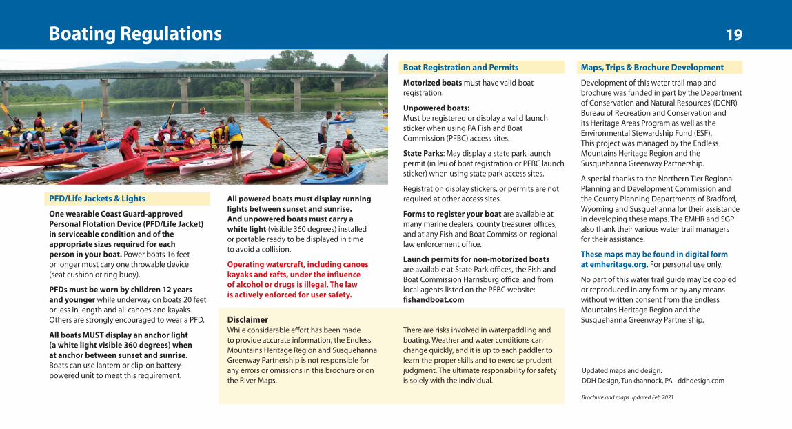
PFD/Life Jackets & Lights
One wearable Coast Guard-approvedPersonal Flotation Device (PFD/Life Jacket) in serviceable condition and of theappropriate sizes required for each person in your boat. Power boats 16 feet or longer must cary one throwable device (seat cushion or ring buoy).
PFDs must be worn by children 12 years and younger while underway on boats 20 feetor less in length and all canoes and kayaks.Others are strongly encouraged to wear a PFD.
All boats MUST display an anchor light (a white light visible 360 degrees) when at anchor between sunset and sunrise. Boats can use lantern or clip-on battery-powered unit to meet this requirement.
DisclaimerWhile considerable effort has been madeto provide accurate information, the EndlessMountains Heritage Region and SusquehannaGreenway Partnership is not responsible for any errors or omissions in this brochure or onthe River Maps.
Boat Registration and Permits
Motorized boats must have valid boatregistration.
Unpowered boats:Must be registered or display a valid Iaunchsticker when using PA Fish and BoatCommission (PFBC) access sites.
State Parks: May display a state park launchpermit (in leu of boat registration or PFBC launchsticker) when using state park access sites.
Registration display stickers, or permits are notrequired at other access sites.
Forms to register your boat are available atmany marine dealers, county treasurer offices,and at any Fish and Boat Commission regionallaw enforcement office.
Launch permits for non-motorized boats are available at State Park offices, the Fish andBoat Commission Harrisburg office, and fromlocal agents listed on the PFBC website:fishandboat.com
Maps, Trips & Brochure Development
Development of this water trail map andbrochure was funded in part by the Departmentof Conservation and Natural Resources’ (DCNR)Bureau of Recreation and Conservation and its Heritage Areas Program as well as theEnvironmental Stewardship Fund (ESF). This project was managed by the EndlessMountains Heritage Region and theSusquehanna Greenway Partnership.
A special thanks to the Northern Tier RegionalPlanning and Development Commission andthe County Planning Departments of Bradford,Wyoming and Susquehanna for their assistancein developing these maps. The EMHR and SGPalso thank their various water trail managers for their assistance.
These maps may be found in digital form at emheritage.org. For personal use only.
No part of this water trail guide may be copiedor reproduced in any form or by any meanswithout written consent from the EndlessMountains Heritage Region and theSusquehanna Greenway Partnership.
All powered boats must display runninglights between sunset and sunrise.And unpowered boats must carry a white light (visible 360 degrees) installed or portable ready to be displayed in time to avoid a collision.
Operating watercraft, including canoeskayaks and rafts, under the influence of alcohol or drugs is illegal. The law is actively enforced for user safety.
There are risks involved in waterpaddling andboating. Weather and water conditions canchange quickly, and it is up to each paddler tolearn the proper skills and to exercise prudentjudgment. The ultimate responsibility for safetyis solely with the individual.
Updated maps and design:DDH Design, Tunkhannock, PA - ddhdesign.com
Brochure and maps updated Feb 2021
Boating Regulations 19
9feb21-20pg-12x13-cx2.qxp_Layout 1 2/10/21 3:11 PM Page 19
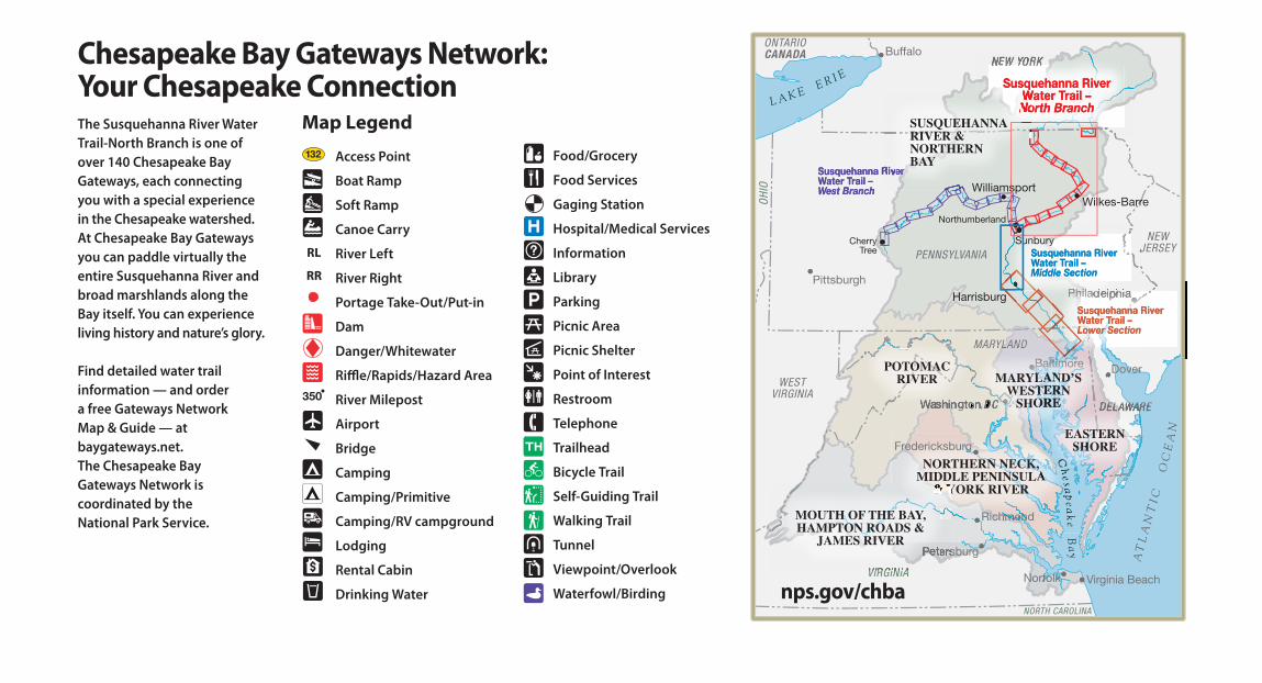
The Susquehanna River WaterTrail-North Branch is one ofover 140 Chesapeake BayGateways, each connectingyou with a special experiencein the Chesapeake watershed.At Chesapeake Bay Gatewaysyou can paddle virtually theentire Susquehanna River andbroad marshlands along theBay itself. You can experienceliving history and nature’s glory.
Find detailed water trailinformation — and order a free Gateways Network Map & Guide — atbaygateways.net. The Chesapeake Bay Gateways Network iscoordinated by the National Park Service.
Access Point
Boat Ramp
Soft Ramp
Canoe Carry
River Left
River Right
Portage Take-Out/Put-in
Dam
Danger/Whitewater
Ri!e/Rapids/Hazard Area
River Milepost
Airport
Bridge
Camping
Camping/Primitive
Camping/RV campground
Lodging
Rental Cabin
Drinking Water
Map Legend
350
132
RL
RR
Food/Grocery
Food Services
Gaging Station
Hospital/Medical Services
Information
Library
Parking
Picnic Area
Picnic Shelter
Point of Interest
Restroom
Telephone
Trailhead
Bicycle Trail
Self-Guiding Trail
Walking Trail
Tunnel
Viewpoint/Overlook
Waterfowl/Birding
Chesapeake Bay Gateways Network:Your Chesapeake Connection
nps.gov/chba
22feb21-20pg-12x13-cx3.qxp_Layout 1 2/22/21 12:09 PM Page 20
Recommended