PO Box 3005 Wamberal NSW 2260 T 0404 858573 E kristy@[email protected]
Kristy McQueen operates as a Sole Trader under registered business name Coast Ecology ABN: 249 246 74371
i
Beyond Environmental Consulting Drainage Works
Tuggerah Parade, Long Jetty
Aquatic Assessment Job No: 141017
Date: 27 November 2014
COAST ECOLOGY
Environmental Assessment
PO Box 3005 Wamberal NSW 2260 T 0404 858573 E kristy@[email protected]
Kristy McQueen operates as a Sole Trader under registered business name Coast Ecology ABN: 249 246 74371
i
This aquatic assessment has been prepared by Dr Kristy McQueen for proposed drainage works at Tuggerah Parade, Long Jetty, in response to a request from Beyond Environmental Consulting.
Issue Date Description Author Reviewed By
A 07/11/14 Draft KM MM
B 27/11/14 Final KM CO
PO Box 3005 Wamberal NSW 2260 T 0404 858573 E kristy@[email protected]
Kristy McQueen operates as a Sole Trader under registered business name Coast Ecology ABN: 249 246 74371
i
Executive Summary Wyong Shire Council propose to undertake drainage works at six drainage lines along Tuggerah Parade at Long Jetty. The works are restricted to the drainage lines and works will not directly impact the seagrass beds and aquatic fauna adjoining the Subject site.
There is no habitat potential in the Subject site or broader Study Area for threatened aquatic species listed on either the FM Act or the EPBC Act. The potential indirect impacts of the proposed works on protected flora and fauna that occur in the broader Study Area are considered in this assessment.
The drainage lines do contain refuge/fish habitat however due to poor water quality and a thick layer of Casuarina glauca needles, the habitat available to benthos is considered low in the drainage lines.
Mitigation measures are provided to minimize impacts on the aquatic flora and fauna in the Subject Site and broader Study Area during the proposed drainage works.

Beyond Environmental Consulting
Drainage Works Tuggerah Pde, Long Jetty: Aquatic Assessment
Page 2 KM/141007/141127
Contents
1. INTRODUCTION ................................................. 3
2. SITE DESCRIPTION ............................................. 3
3. PROPOSED DEVELOPMENT .................................... 3
4. METHODS ....................................................... 3
4.1 DESKTOP ASSESSMENT ............................... 3
4.2 EXPERIMENTAL DESIGN .............................. 4
4.3 LIMITATIONS........................................... 4
5. RESULTS ......................................................... 5
5.1 DESKTOP ASSESSMENT ............................... 5
5.2 WATER QUALITY ...................................... 5
5.3 HABITAT ASSESSMENT ................................ 6
5.3.1 DRAINAGE LINES .................................. 6
5.3.2 LAKE ENVIRONMENT ............................. 8
6. ASSESSMENT ................................................... 10
6.1 ASSUMPTIONS ........................................ 10
7. MITIGATION MEASURES ...................................... 11
8. REFERENCES ................................................... 11
9. FIGURES ........................................................ 12
10. APPENDIX 1. HABITAT ASSESSMENT ........................ 16

Beyond Environmental Consulting
Drainage Works Tuggerah Pde, Long Jetty: Aquatic Assessment
Page 3 KM/141007/141127
1. INTRODUCTION
Coast Ecology was engaged by Beyond Environmental Consulting to undertake an aquatic assessment for proposed drainage works at Tuggerah Parade, Long Jetty. Wyong Shire Council (WSC) propose to design a constructed wetland at the Venice St outlet and re-design the six stormwater outlets between Lake St and Gladstan St.
For the purpose of this assessment, the Subject Site is defined as the zone of disturbance at each of the six outlets. The Study Area includes the Subject Site along with broader Tuggerah Lake environment that may be indirectly impacted by the proposed works.
2. SITE DESCRIPTION
The Subject Site is located at the south eastern end of Tuggerah Lake. The foreshore area includes Tuggerah Lake foreshore shared pathway network. This network comprises a continuous 25km off-road shared pathway, predominately foreshore, from Tuggerah to The Entrance North. The shared pathway is used extensively by pedestrians, cyclists and the wider community.
The general area is characterized by parklands with areas of both intact and disturbed vegetation including Estuarine Swamp Oak Forest, Saltmarsh communities and areas of cleared land with exotic grasses. Residential development characterizes the area on the other side of Tuggerah Parade.
3. PROPOSED DEVELOPMENT
Wyong Shire Council plans to make the 2km foreshore at Long Jetty more attractive and increase use by the community. The stormwater outlets along the foreshore to Tuggerah Lake are overgrown and restrict the foreshores use.
Each outlet comprises approximately 30 meters of narrow open drain between the end of the pipe system and the lake edge. Each open drain is constantly filled with lake water due to the pipe system being below the lake level. Since the lake is not tidal the water in the drains does not get flushed and remains stagnant and turbid. The open drains are overgrown with Casuarina glauca that restrict vegetation growth by blocking sunlight and covering the ground with a mat of needles. Council propose to design a constructed wetland at the Venice St outlet and re-design the six stormwater outlets between Lake St and Gladstan St.
4. METHODS
4.1 DESKTOP ASSESSMENT
A database search was conducted within a 10 km radius of the Subject Site from the following databases:
Australian Government: Department of the Environment Protected Matters Search Tool for Matters of National Environmental Significance (NES) listed under the Environmental Protection and Biodiversity Conservation Act 1999 (EPBC Act) that may occur in the Study Area. a point search was conducted on 05/11/14 using search coordinates:-33.366458, 151.473145 http://www.environment.gov.au/topics/about-us/legislation/environment-protection-and-biodiversity-conservation-act-1999/protected
NSW Department of Primary Industries (DPI): Mapping the estuarine habitats of NSW was consulted for seagrass/saltmarsh mapping within Tuggerah Lakes (within Wyong LGA and Hunter Central Rivers CMA). http://www.dpi.nsw.gov.au/research/areas/aquatic-ecosystems/estuarine-habitats-maps
Beyond Environmental Consulting
Drainage Works Tuggerah Pde, Long Jetty: Aquatic Assessment
Page 4 KM/141007/141127
4.2 EXPERIMENTAL DESIGN
Aquatic survey design depends on the objectives of the investigation, the nature of the disturbance from the proposed development and how the components of the aquatic ecosystem may respond.
In accordance with Wyong Shire Councils Flora and Fauna Survey Guidelines (2014), the following survey techniques were used:
At each of the six stormwater outlets:
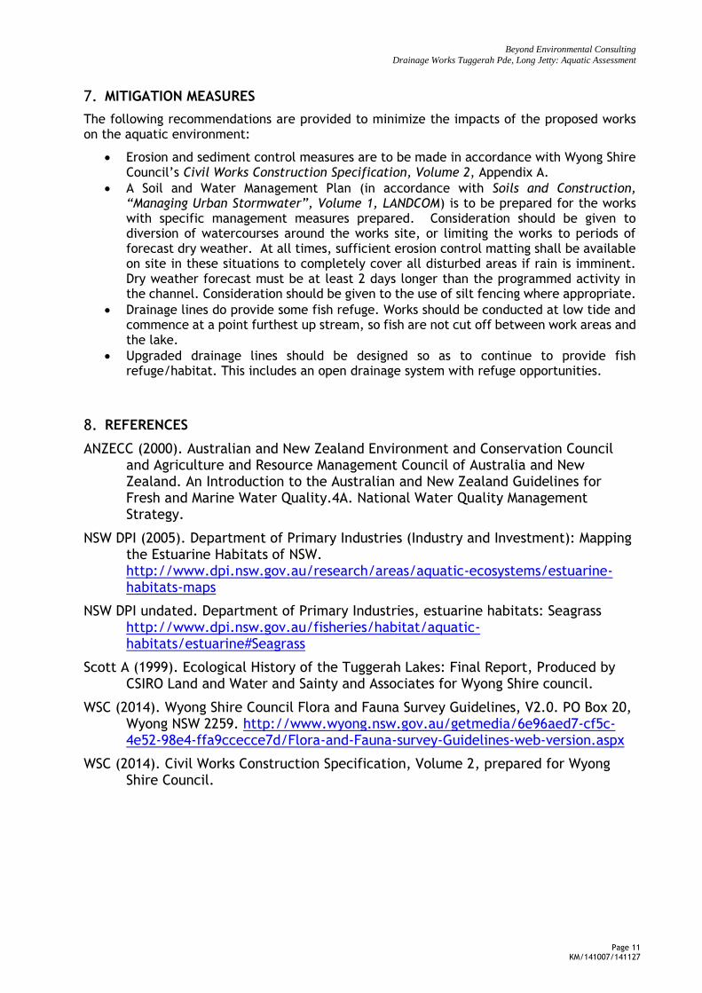
Transects were conducted from the bank to the furthest edge of the flora (seagrass). All flora observed along the transect were recorded (Figure 1).
Three 1x1m randomly placed quadrats were placed along each transect. A measure of %cover of each flora species within the quadrat was recorded (Figure 1). Fauna surveys were based on observation of benthos and fish.
Surface water quality was measured in situ from each of the drainage lines and off Parry’s Jetty using a Yeokall 611 water quality probe. The following variables were recorded:
o Temperature (°C);
o Conductivity (µS/cm);
o pH;
o Oxidation – Reduction Potential (ORP) (mV);
o Dissolved Oxygen (% saturation and mg/L);
o Turbidity (ntu).
Alkalinity was measured using a field titration kit.
Water quality data were compared with the ANZECC (2000) default trigger values to physical and chemical stressors for protection of slightly disturbed aquatic ecosystems in south-eastern Australia.
4.3 LIMITATIONS
The design of the aquatic assessment does not incorporate spatial and/or temporal replication due to budget and time restraints. However, given the limited extent of works within the lake, the current level of assessment is considered adequate to assess the impacts of the proposal.
Wind chop and turbidity were high at the time of survey and visibility was low. While it is possible that species were missed during survey due to poor visibility, it is considered unlikely that any threatened species were present and not observed.
Beyond Environmental Consulting
Drainage Works Tuggerah Pde, Long Jetty: Aquatic Assessment
Page 5 KM/141007/141127
5. RESULTS
5.1 DESKTOP ASSESSMENT
No threatened species, populations or communities listed under the Fisheries Management Act (FM Act) are on record with NSW Fisheries for the Wyong Shire Council LGA or the Hunter Central Rivers Catchment Management Authority (CMA). Following a habitat assessment, the Subject Site and broader Study Area does not contain suitable habitat for any threatened species, population or community listed as threatened under the FM Act. Posidonia australis is listed as an endangered population under the FM Act however this species has not previously been mapped in Tuggerah Lakes (NSW DPI, 2005).
A habitat assessment (Appendix 1) was conducted on fish and sharks that were listed as having potential habitat in the area in the Protected Matters Search (Appendix 2). Only one threatened aquatic species listed under the FM Act or EPBC Act has potential habitat in the broader Study Area: Green Sawfish Pristis zijsron. This species is presumed extinct in NSW, has not been recorded in Tuggerah Lakes, and as such is considered unlikely to occur in the vicinity of the Subject Site. No assessment of significance is required for the proposed works.
Species listed as protected under the FM Act were also considered in this assessment. Protected species with habitat in the Study Area include:
All Seagrass
Weedy Seadragons Phyllopteryx taeniolatus
Syngnathiformes (seahorses, seadragons, pipefish, pipehorses and seamoths) are also protected in that their collection is illegal.
Estuary Cod Epinephelus coioides
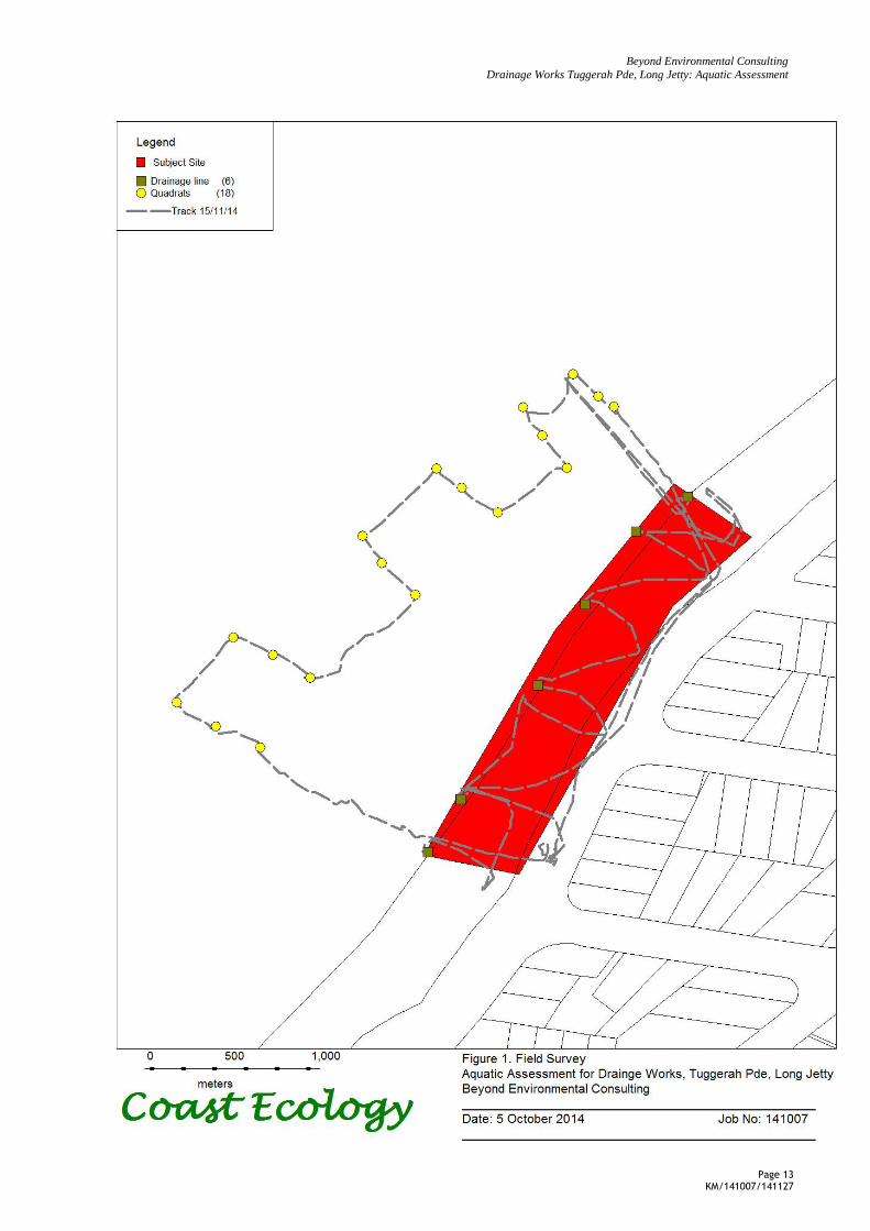
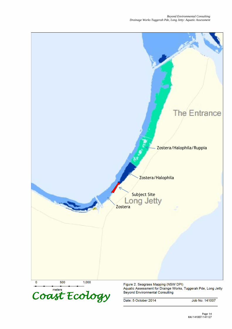
Seagrass mapping by NSW DPI (2005) is presented in Figure 2. The area directly in front of the Subject Site is shown as having Zostera Capricornia beds only. Seagrass beds immediately to the north of the Subject Site also have Halophila spp and beds further north again contain Zostera, Halophila spp and Ruppia spp.
5.2 WATER QUALITY
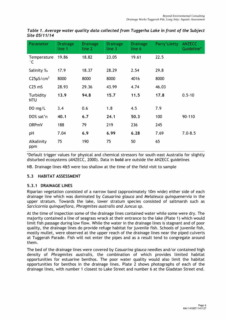
Table 1 shows water quality data results from readings taken from the drainage lines and Parry’s Jetty in Tuggerah Lake which is in front of drainage line 6. ANZECC guidelines provide default trigger values for turbidity, DO% and pH (Table 1).
At the time of sampling, the turbidity in Tuggerah Lake at the sample site was outside the range of the guidelines for slightly disturbed estuarine environments (Table 1). Due to its large size and shallow depths, strong winds can create steep surface waves which increase turbidity in the lake. Winds were up to 15km/hr at the time of sampling which would have contributed to the high turbidity values. The turbidity in the drainage lines also exceeded the guidelines, with drainage line 2 recording very high turbidity levels of 94.8 NTU (Table 1).
The percent dissolved oxygen (DO%) was outside of the guidelines, being well below the trigger values for slightly disturbed estuarine environments (Table 1). This is not surprising considering the current drainage issues and stagnant nature of the drainage lines which is the impetus for the proposed works. As expected for Tuggerah Lakes however, DO% was high (100%) resulting from strong wind and surface wave mixing.
The pH samples collected from the drainage lines were within or just below ANZECC guidelines. Drainage line 6 was only slightly acidic. Water samples collected from Parry’s jetty were within the acceptable guidelines (Table 1).
Beyond Environmental Consulting
Drainage Works Tuggerah Pde, Long Jetty: Aquatic Assessment
Page 6 KM/141007/141127
Table 1. Average water quality data collected from Tuggerha Lake in front of the Subject Site 05/11/14
Parameter Drainage line 1
Drainage line 2
Drainage line 3
Drainage line 6
Parry’sJetty ANZECC Guideline*
Temperature °C
19.86 18.82 23.05 19.61 22.5
Salinity ‰ 17.9 18.37 28.29 2.54 29.8
C25µS/cm3 8000 8000 8000 4016 8000
C25 mS 28.93 29.36 43.99 4.74 46.03
Turbidity NTU
13.9 94.8 15.7 11.5 17.8 0.5-10
DO mg/L 3.4 0.6 1.8 4.5 7.9
DO% sat’n 40.1 6.7 24.1 50.3 100 90-110
ORPmV 188 79 219 236 245
pH 7.04 6.9 6.99 6.28 7.69 7.0-8.5
Alkalinity ppm
75 190 75 50 65
*Default trigger values for physical and chemical stressors for south-east Australia for slightly disturbed ecosystems (ANZECC, 2000). Data in bold are outside the ANZECC guidelines
NB. Drainage lines 4&5 were too shallow at the time of the field visit to sample
5.3 HABITAT ASSESSMENT
5.3.1 DRAINAGE LINES
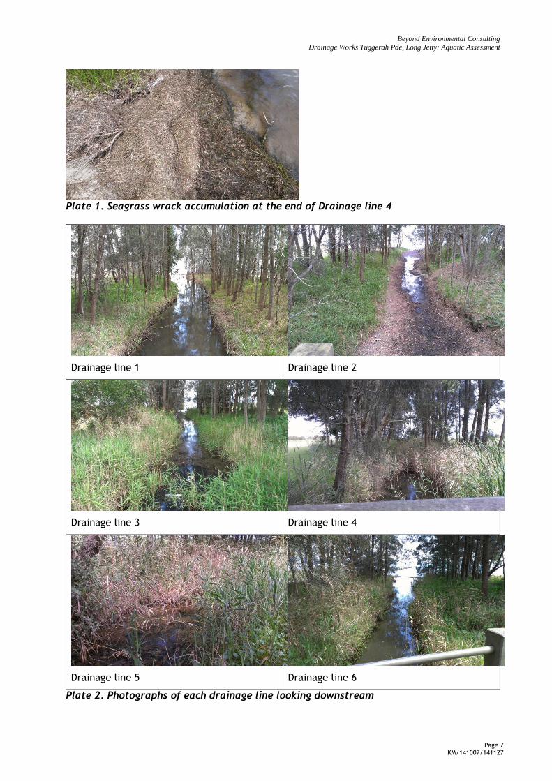
Riparian vegetation consisted of a narrow band (approximately 10m wide) either side of each drainage line which was dominated by Casuarina glauca and Melaleuca quinquenervia in the upper stratum. Towards the lake, lower stratum species consisted of saltmarsh such as Sarcicornia quinqueflora, Phragmites australis and Juncus sp.
At the time of inspection some of the drainage lines contained water while some were dry. The majority contained a line of seagrass wrack at their entrance to the lake (Plate 1) which would limit fish passage during low flow. While the water in the drainage lines is stagnant and of poor quality, the drainage lines do provide refuge habitat for juvenile fish. Schools of juvenile fish, mostly mullet, were observed at the upper reach of the drainage lines near the piped culverts at Tuggerah Parade. Fish will not enter the pipes and as a result tend to congregate around them.
The bed of the drainage lines were covered by Casuarina glauca needles and/or contained high density of Phragmites australis, the combination of which provides limited habitat opportunities for estuarine benthos. The poor water quality would also limit the habitat opportunities for benthos in the drainage lines. Plate 2 shows photographs of each of the drainage lines, with number 1 closest to Lake Street and number 6 at the Gladstan Street end.
Beyond Environmental Consulting
Drainage Works Tuggerah Pde, Long Jetty: Aquatic Assessment
Page 7 KM/141007/141127
Plate 1. Seagrass wrack accumulation at the end of Drainage line 4
Drainage line 1
Drainage line 2
Drainage line 3
Drainage line 4
Drainage line 5
Drainage line 6
Plate 2. Photographs of each drainage line looking downstream
Beyond Environmental Consulting
Drainage Works Tuggerah Pde, Long Jetty: Aquatic Assessment
Page 8 KM/141007/141127
5.3.2 LAKE ENVIRONMENT
Fauna
The types of fish caught commercially in the Tuggerah Lakes changes from year to year however the same species that made up the bulk of catch historically continue to be important and include mullet, blackfish, bream, garfish, whiting, flathead (Scott, 1999). During site visit, mullet and bream were observed around the jetty.
In amongst the seagrass, shells of Sydney Cockle Anadara trapezia and Sydney mud whelks Velacumantus australis were common however no live molluscs were collected during surveys.
Flora
Seagrasses occur in the intertidal and subtidal zones of estuaries. The area of seagrass beds can be highly variable seasonally as seagrasses die back during the cooler months and re-establish in warmer months of the year. Seagrasses are the only flowering plants that can live underwater. The most common species in Tuggerah Lakes are Zostera capricorni (eelgrass) and Halophila ovalis (paddleweed) and Ruppia megacarpa (Stackweed). Seagrasses are particularly valuable as nursery, feeding and shelter areas for many aquatic animals, including commercially and recreationally important fish, crabs and prawns. Like other estuarine vegetation, seagrasses contribute organic matter to the food chain, and remove nutrients from the water (NSW DPI, undated).
Based on transects and quadrats in the lake bed directly in front of each of the drainage lines, the seagrass bed was found to consist of only one species: Zostera capriconia. This is consistent with NSW DPI mapping (Figure 2). The Z. capricornia beds commenced approximately 111 m out from Drainage line 1 and at its closest point, approximately 56m out from Drainage line 5 (Figure 1). It occurred in depths from 0.4 m to 1.1 m.
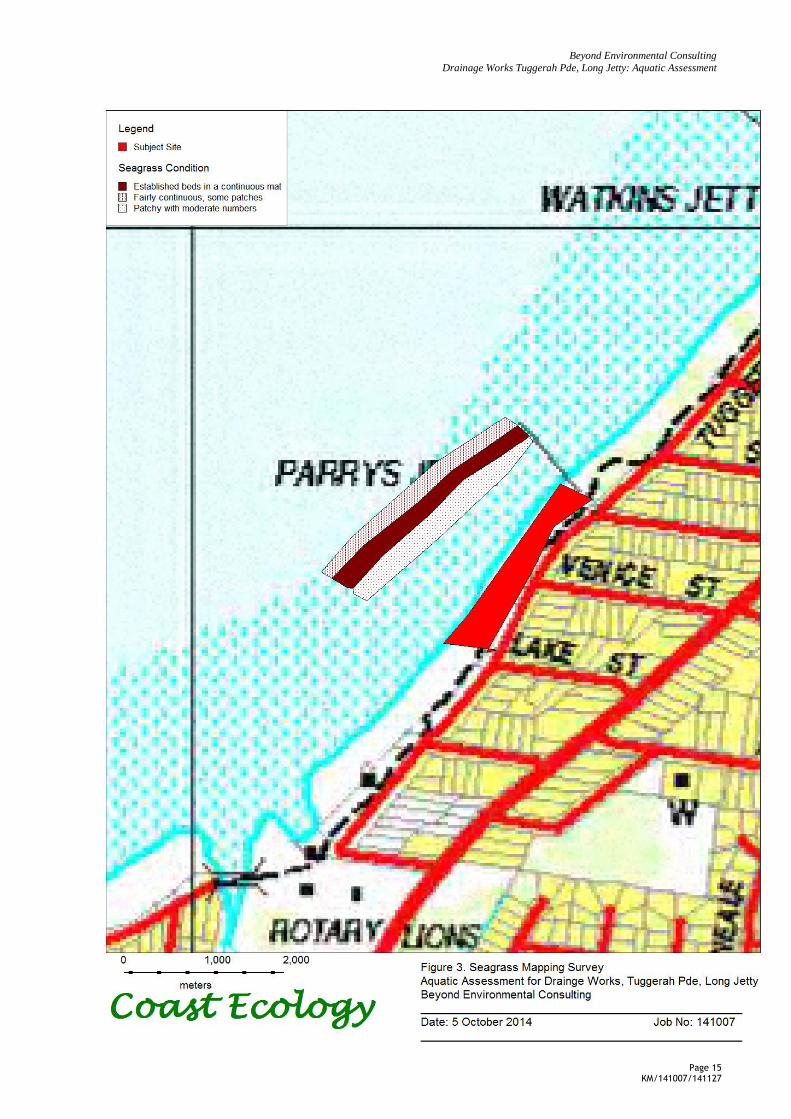
Zostera capriconia in the middle of the seagrass bed was a continuous mat with long (~40cm leaves. Around the perimeter of the bed however, the seagrass was patchy and did not appear as a healthy continuous mat (Figure 3). This is likely a combination of temporal variation in seagrass health (i.e dieback over winter) and anthropogenic factors impacting the seagrass. Human impacts on the seagrass include stormwater input, recreation use such as boating and swimming and the practice of wrack harvesting. These impacts either directly affect the seagrass beds through removal or trampling or indirectly affect the beds by increasing turbidity which limits light availability to the plants.
Macroalgae occurred over the seagrass in varying amounts. Large blooms of macroalgae can occur when nutrients are available which tends to indicate poor nutrient quality. The % cover of macroalge was higher closer to the shore. This may also contribute to the patchy distribution of seagrass closer to the shore. Macroalgae observed in the Study Area immediately in front of the Subject Site includes the green algae Enteromorpha and Rhizoclonium and the red algae Gracilaria verrucosa.
The substrate between the shoreline and the start of the Zostera capriconia seagrass was covered with a layer of fine sediment. Many sink holes occur where substrate is unstable.
Table 2 below shows co-ordinates for each quadrat, the % cover of Z. capricornia, the % cover of macroalgae covering the seagrass and the approximate depth. The provision of this information is in accordance with Councils flora and fauna guidelines for aquatic assessments (WSC, 2014).
Beyond Environmental Consulting
Drainage Works Tuggerah Pde, Long Jetty: Aquatic Assessment
Page 9 KM/141007/141127
Table 2. Percent cover of seagrass per quadrat
Drainage Line Quadrat Map X Map Y Quadrat % Zostera Cover*
% Macroalgae Depth m
1 1 -33.3619 151.476 1 70 30 0.6
2 -33.3618 151.476 2 90 25 0.8
3 -33.3617 151.476 3 80 20 1.1
2 4 -33.3613 151.476 1 55 15 0.6
5 -33.3614 151.476 2 85 15 0.8
6 -33.3619 151.476 3 75 10 1.1
3 7 -33.361 151.477 1 45 15 0.6
8 -33.3611 151.477 2 85 10 0.8
9 -33.361 151.477 3 70 10 1.1
4 10 -33.3608 151.477 1 45 15 0.4
11 -33.3605 151.477 2 80 10 0.6
12 -33.3606 151.477 3 55 10 0.8
5 13 -33.3607 151.478 1 40 10 0.5
14 -33.3605 151.478 2 80 5 0.5
15 -33.3603 151.478 3 90 5 0.7
6 16 -33.3602 151.478 1 10 2 0.4
17 -33.36 151.478 2 2 2 0.5
18 -33.3601 151.478 3 70 5 0.6
*1x1m quadrad. At each drainage line, quadrats were numbered from the shore lake ward.

Beyond Environmental Consulting
Drainage Works Tuggerah Pde, Long Jetty: Aquatic Assessment
Page 10 KM/141007/141127
6. ASSESSMENT
The drainage lines do provide refuge/habitat for juvenile fish species, however it is unlikely that the drainage lines provide important habitat for benthos or crustaceans due to the poor water quality and the thick layer of C. glauca needles in the drainage lines. Mitigation measures provided in Section 7 of this assessment will minimise the impacts of the construction works on any juvenile fish species utilising the drainage lines. As the final designs of the proposed drainage line upgrade have not been completed, the long term impact of the works on the availability of fish habitat in the drainage lines is not known.
The proposed works involve dredging/reclamation within the drainage lines however no works are proposed in the lake bed. As such, there will be no direct impacts on seagrass or fauna within the lake. There is the potential for indirect impacts resulting from works to affect the habitat within the broader Study Area. Dredging and reclamation within the drainage lines may result in high turbidity in the lake and shading of the seagrass beds. Mitigation measures have been provided in Section 7 of this report to minimise the impacts of works on the nearby seagrass beds.
Following the completion of works, stormwater run-off entering the lake will be treated and dispersed, rather than entering at fixed points. This will have a beneficial outcome for the lake environment, with reduced souring, reduced nutrient/heavy metal input and reduced turbidity.
No threatened aquatic species listed under the FM Act or EPBC Act were considered likely to occur in the Subject Site or broader Study Area however the broader Study Area does contain potential habitat for protected species such as seagrass, weedy sea dragons and other syngnathids.
With the implementation of appropriate mitigation measures, the proposed works are considered unlikely to impact any threatened or protected aquatic species listed under the FM Act or the EPBC Act.
6.1 ASSUMPTIONS
Aquatic mammals and reptiles listed under the TSC Act and/or EPBC Act will be
considered as part of the terrestrial flora and fauna assessment.
No direct impacts (i.e. dredging and/or reclamation) will occur within lake bed
Following the completion of works, direct flows from the drainage lines into Tuggerah Lakes will be reduced and stormwater will enter the lake as sheet flows.
Beyond Environmental Consulting
Drainage Works Tuggerah Pde, Long Jetty: Aquatic Assessment
Page 11 KM/141007/141127
7. MITIGATION MEASURES
The following recommendations are provided to minimize the impacts of the proposed works on the aquatic environment:
Erosion and sediment control measures are to be made in accordance with Wyong Shire Council’s Civil Works Construction Specification, Volume 2, Appendix A.
A Soil and Water Management Plan (in accordance with Soils and Construction, “Managing Urban Stormwater”, Volume 1, LANDCOM) is to be prepared for the works with specific management measures prepared. Consideration should be given to diversion of watercourses around the works site, or limiting the works to periods of forecast dry weather. At all times, sufficient erosion control matting shall be available on site in these situations to completely cover all disturbed areas if rain is imminent. Dry weather forecast must be at least 2 days longer than the programmed activity in the channel. Consideration should be given to the use of silt fencing where appropriate.
Drainage lines do provide some fish refuge. Works should be conducted at low tide and commence at a point furthest up stream, so fish are not cut off between work areas and the lake.
Upgraded drainage lines should be designed so as to continue to provide fish refuge/habitat. This includes an open drainage system with refuge opportunities.
8. REFERENCES
ANZECC (2000). Australian and New Zealand Environment and Conservation Council and Agriculture and Resource Management Council of Australia and New Zealand. An Introduction to the Australian and New Zealand Guidelines for Fresh and Marine Water Quality.4A. National Water Quality Management Strategy.
NSW DPI (2005). Department of Primary Industries (Industry and Investment): Mapping the Estuarine Habitats of NSW. http://www.dpi.nsw.gov.au/research/areas/aquatic-ecosystems/estuarine-habitats-maps
NSW DPI undated. Department of Primary Industries, estuarine habitats: Seagrass http://www.dpi.nsw.gov.au/fisheries/habitat/aquatic-habitats/estuarine#Seagrass
Scott A (1999). Ecological History of the Tuggerah Lakes: Final Report, Produced by CSIRO Land and Water and Sainty and Associates for Wyong Shire council.
WSC (2014). Wyong Shire Council Flora and Fauna Survey Guidelines, V2.0. PO Box 20, Wyong NSW 2259. http://www.wyong.nsw.gov.au/getmedia/6e96aed7-cf5c-4e52-98e4-ffa9ccecce7d/Flora-and-Fauna-survey-Guidelines-web-version.aspx
WSC (2014). Civil Works Construction Specification, Volume 2, prepared for Wyong Shire Council.
Beyond Environmental Consulting
Drainage Works Tuggerah Pde, Long Jetty: Aquatic Assessment
Page 12 KM/141007/141127
9. FIGURES
Beyond Environmental Consulting
Drainage Works Tuggerah Pde, Long Jetty: Aquatic Assessment
Page 13 KM/141007/141127
Beyond Environmental Consulting
Drainage Works Tuggerah Pde, Long Jetty: Aquatic Assessment
Page 14 KM/141007/141127
Zostera/Halophila
Zostera/Halophila/Ruppia
Zostera
Subject Site
Beyond Environmental Consulting
Drainage Works Tuggerah Pde, Long Jetty: Aquatic Assessment
Page 15 KM/141007/141127

Beyond Environmental Consulting
Drainage Works Tuggerah Pde, Long Jetty: Aquatic Assessment
Page 16 KM/141007/141127
10. APPENDIX 1. HABITAT ASSESSMENT
Species Status Distribution and Ecology Habitat in Study Area
Fish
Black Rockcod
Epinephelus daemelii
V (EPBC
Act)
V (FM
Act)
Black cod, also known as black rockcod or black-saddled rockcod, are a large,
reef-dwelling, carnivorous grouper species. They are found in warm temperate
and subtropical parts of the south-western Pacific, and naturally occurred along
the entire NSW coast including Lord Howe Island.
Adult black cod are usually found in caves, gutters and beneath bomboras on
rocky reefs. They are territorial and often occupy a particular cave for life. Small
juveniles are often found in coastal rock pools, and larger juveniles around rocky
shores in estuaries.
Black cod are opportunistic carnivores, eating mainly other fish and crustaceans.
They can change from one colour pattern to another in just a few seconds. They
are usually black in estuaries and banded around clear water reefs.
Black cod are apparently slow growing. Smaller fish are mostly females, but they
generally change sex to become males at around 100-110 cm in length.
Nil. Study Area lacks reef.
Macquarie Perch
Macquaria
australasica
E (EPBC
Act)
E (FM
act)
Macquarie perch are found in the Murray-Darling Basin (particularly upstream
reaches) of the Lachlan, Murrumbidgee and Murray rivers, and parts of south-
eastern coastal NSW, including the Hawkesbury and Shoalhaven catchments. The
conservation status of the different populations is not well known, but there have
been long-term declines in their abundance.
Habitat and Ecology
Macquarie perch are found in both river and lake habitats, especially the upper
reaches of rivers and their tributaries.
They are quiet, furtive fish that feed on aquatic insects, crustaceans and
molluscs.
Sexual maturity occurs at two years for males and three years for females.
Macquarie perch spawn in spring or summer in shallow upland streams or flowing
parts of rivers.
Females produce around 50,000-100,000 eggs which settle among stones and
Nil. Not found in Hunter/Central Rivers
Catchment.
Beyond Environmental Consulting
Drainage Works Tuggerah Pde, Long Jetty: Aquatic Assessment
Page 17 KM/141007/141127
gravel of the stream or river bed.
Australian Grayling
Prototroctes
maraena
V (EPBC
Act)
Currently, the Australian Grayling occurs in streams and rivers on the eastern and
southern flanks of the Great Dividing Range, from Sydney, southwards to the
Otway Ranges of Victoria and in Tasmania. The species is found in fresh and
brackish waters of coastal lagoons, from Shoalhaven River in NSW to Ewan Ponds
in South Australia.
The Australian Grayling is diadromous, spending part of its lifecycle in freshwater
and at least part of the larval and/or juvenile stages in coastal seas
Unlikely. Distribution is further south of
Sydney.
Sharks
Grey Nurse Shark
(east coast
population)
Carcharias Taurus
CE (EPBC
Act)
CE (FM
Act)
Grey nurse sharks are a large shark native to subtropical to cool temperate
waters in the Mediterranean Sea and the Atlantic, Indian and western Pacific
Oceans. Once widely distributed, they are now mainly restricted to Australia and
the east coasts of the USA, Uruguay, Argentina and South Africa. In Australia
there is an east coast and a west coast population. The east coast population is
found predominantly in inshore coastal waters along the coast of NSW and
southern Queensland. There are a number of key habitat sites along the coast of
NSW and southern Queensland where grey nurse sharks are regularly found in
groups. These sites generally have sandy-bottomed gutters or rocky caves and
are in the vicinity of inshore rocky reefs or islands.
Habitat and Ecology
Grey nurse sharks are mainly active at night and feed on a wide range of bony
fishes, sharks, rays, squids and crustaceans.
Sexual maturity is reached in about 4-6 years for males and 6-8 years for females,
at lengths of around 1.9m and 2.2m for males and females respectively.
Mating probably occurs in autumn and females are likely to give birth in winter
at the sites where they aggregate.
Grey nurse sharks breed in a highly unusual way. Towards the end of their 9-12
month gestation period the most advanced embryos eat the remaining developing
embryos and then the unfertilised eggs within the female shark's uterus. This
results in the birth of only one or two pups per litter. Females then enter a resting
stage for around one year.
As a result of this two-yearly reproductive cycle, females produce one pup per
year or less on average, which gives this species the lowest reproductive rate of
Low. Unlikely to occur in estuarine
environments.

Beyond Environmental Consulting
Drainage Works Tuggerah Pde, Long Jetty: Aquatic Assessment
Page 18 KM/141007/141127
any shark and makes them extremely vulnerable to human-induced pressures.
Great White Shark
Carcharodon
carcharias
V (EPBC
Act)
V (FM
Act)
Great white sharks are found throughout the world in temperate and subtropical
oceans, with a preference for cooler waters. This distribution includes the
coastal waters of NSW. Great white sharks are responsible for attacks on humans
and have had a high media profile in recent years. However, scientific evidence
suggests that their numbers and average size have declined over the last few
decades. Their natural rarity, low natural mortality, low reproductive rate and
other life history characteristics make their populations highly vulnerable to the
impacts of fishing.
Habitat and Ecology
Relatively little is known about the biology of great white sharks because of their
rarity and the difficulties and dangers of studying large, live individuals.
Great white sharks are normally found in inshore waters around rocky reefs and
islands, and often near seal colonies. They have been recorded at varying depths
down to 1200m.
They may travel large distances in a relatively short time but can remain in the
same area for weeks or even months.
As apex predators (at the top of the food chain), great white sharks play an
important role in marine ecosystems.
Juveniles feed mainly on fish and adults mainly on other sharks, rays and marine
mammals.
Great white sharks reach sexual maturity at around 10 years of age. They
probably do not breed every year. Females give birth to relatively few pups
(between 4 and 10). They are fully developed and independent at birth, and
measure around 120-150 cm in length.
Low. Unlikely to occur in estuarine
environments.
Green Sawfish
Pristis zijsron
V (EPBC
Act)
PE (FM
Act)
Green sawfish were once widely distributed in the northern Indian Ocean, around
South and South-East Asia and around northern Australia. However, their
numbers have been greatly reduced by fishing and accidental capture in prawn
trawl and gill nets. Their large size and saw allow them to easily become
entangled in nets and they are difficult to remove, and so rarely survive capture.
The natural distribution of green sawfish originally extended from the
Queensland border to the NSW south coast (Shoalhaven River).
Green sawfish live on muddy or sandy-mud soft bottom habitats in inshore areas.
Potential habitat in the broader Study
Area however this species is presumed
extinct and is considered unlikely to
occur within the Study Area.
There have been no records of this
species in Tuggerah Lakes.
Beyond Environmental Consulting
Drainage Works Tuggerah Pde, Long Jetty: Aquatic Assessment
Page 19 KM/141007/141127
They also enter estuaries, where they have been found in very shallow water.
They feed on slow-moving, shoaling fish such as mullet, which they stun with
sideswipes of the snout. They also use their saw to sweep other prey, such as
molluscs and small crustaceans, out of the sand and mud.
Green sawfish probably don’t reach sexual maturity until they are at least 2-3
metres in length. Like all sharks and rays, they have internal fertilisation and
give birth to a limited number of live young.
Whale Shark
Rhincodon typus
V, M
(EPBC
Act)
In Australia, the Whale Shark is known from NSW, Queensland, Northern
Territory, Western Australia and occasionally Victoria and South Australia, but it
is most commonly seen in waters off northern Western Australia, Northern
Territory and Queensland.
The Whale Shark is an oceanic and coastal, tropical to warm-temperate pelagic
shark. It is often seen far offshore, but also comes close inshore and sometimes
enters lagoons of coral atolls.
Nil.
Recommended