Centre for Advanced Spatial Analysis, University College LondonCentre for Advanced Spatial Analysis
Urban Models:Urban Models:The Decline of Theory, The Rise of Big Data The Decline of Theory, The Rise of Big Data
and the Fragmentation of Applicationsand the Fragmentation of Applications
Michael BattyUniversity College London
t @jmichaelbatty
ECNU Writing Workshop, October 28th, 2012CAMUSS

Centre for Advanced Spatial Analysis, University College LondonCentre for Advanced Spatial Analysis
Themes
• Defining Urban Models: A Generic Type
• Theory, Data, Models, Policy Applications
• The Decline of Theory and Rise of Data, & Refocusing on Smart Cities
• Land Use Transportation Models: LUTI
• Cellular Automata and Agent Based Models
• The New Short Termism: The Fragmentation of Applications and the New Plurality of Planning
• Future Prospects

Centre for Advanced Spatial Analysis, University College LondonCentre for Advanced Spatial Analysis
Defining Urban Models: A Generic TypeThese are computer models that explain and predict
urban outcome such as land uses and activities therein
They are built on mathematical structures in the broadest sense of the word that range from formal and analytical equation systems to rule-based logics
They are applicable at urban scales from the metro-region to the local district level but rarely outside these scales
They either predict spatial outcomes at a cross section in time or outcomes that change in time: these types are called static or dynamic

Centre for Advanced Spatial Analysis, University College LondonCentre for Advanced Spatial Analysis
We can write their structure as a generic type and the basic equation is called a reaction-diffusion equation. It can be written as follows
We can derive any urban model we like from this generic structure by suppressing space, time, reaction, diffusion, & external effects – & we will show how below
IZj
itjtitit XAAA )1(1
spatial outcome iat time t+1.
spatial outcome iat time t.
spatialdiffusionfrom i to j
externaleffect on i
reaction diffusion external effect/input

Centre for Advanced Spatial Analysis, University College LondonCentre for Advanced Spatial Analysis
Urban models depend on two kinds of theory –
first a theory of the city which is absolutely key to the formulation of the model, and
second a theory of how the model might be used which in essence is not a theory of the city but a theory of planning
Urban models that began almost as soon as computers moved out the scientific lab – perhaps even in the lab in the early 1950s – were in fact articulated not for scientific purposes per se but for policy applications
The first example was the Chicago Area Transportation Study (CATS) which began in the mid 1950s
Centre for Advanced Spatial Analysis, University College LondonCentre for Advanced Spatial Analysis
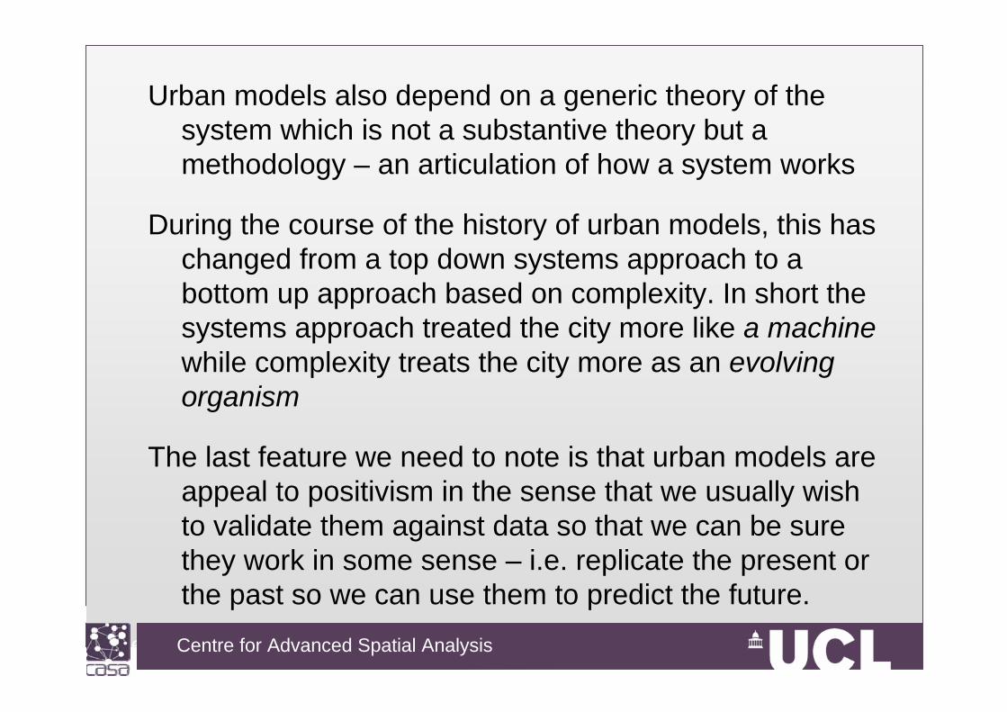
Urban models also depend on a generic theory of the system which is not a substantive theory but a methodology – an articulation of how a system works
During the course of the history of urban models, this has changed from a top down systems approach to a bottom up approach based on complexity. In short the systems approach treated the city more like a machinewhile complexity treats the city more as an evolving organism
The last feature we need to note is that urban models are appeal to positivism in the sense that we usually wish to validate them against data so that we can be sure they work in some sense – i.e. replicate the present or the past so we can use them to predict the future.

Centre for Advanced Spatial Analysis, University College LondonCentre for Advanced Spatial Analysis
Theory, Data, Models, Policy Applications
In fact, all of these assumptions have been questioned during the last 50 - 60 years and we now need to make this history explicit. We will divide our history into four streams – implying how urban models have grappled with theory (of cities), data, methodology and applications (in planning)
Theory Data Methods Applications
1950s1960s1970s1980s1990s2000s2010s

Centre for Advanced Spatial Analysis, University College LondonCentre for Advanced Spatial Analysis
Theory Data Methods Applications
1950s
1960s
1970s
1980s
1990s
2000s
2010s fragmented big data complexity partial occasionalPSS/DSS
comprehensive small data whole systems comprehensiveland use transportLand Use Transportation
Interaction Models (LUTI)
Cellular AutomataModels (CA)
Agent-Based Models (ABM)
Spatial Econometric (SE)
Micro-Simulation (MS)
Systems-Dynamics (MS)

Centre for Advanced Spatial Analysis, University College LondonCentre for Advanced Spatial Analysis
Theory Data Methods Applications
1950s1960s1970s1980s1990s2000s2010s fragmented big data complexity partial occasional
PSS/DSS
comprehensive small data whole systems comprehensiveland use transport
A gradual loosening of theory, a gradual abandonment of comprehensiveness, a much more pragmatic approach to applications, and a concentration on data. GIS is part of this, so is the idea of the smart city, of data everywhere, accessible anytime, anywhere
The Decline of Theory and the Rise of Data, and Refocusing on Smart Cities

Centre for Advanced Spatial Analysis, University College LondonCentre for Advanced Spatial Analysis
1950s1960s1970s1980s1990s2000s2010s dynamic disaggregate temporal complex partial
static aggregate spatial simple comprehensive
A major paradigm shift is now occurring in which our theory of the city in so far as there is one is under intense scrutiny.
The focus is now on much more routine localised change, on short term, diurnal change not long term change – there are many reasons for this but before I sketch these I need to return to LUTI and CA models and sketch their evolution
Centre for Advanced Spatial Analysis, University College LondonCentre for Advanced Spatial Analysis
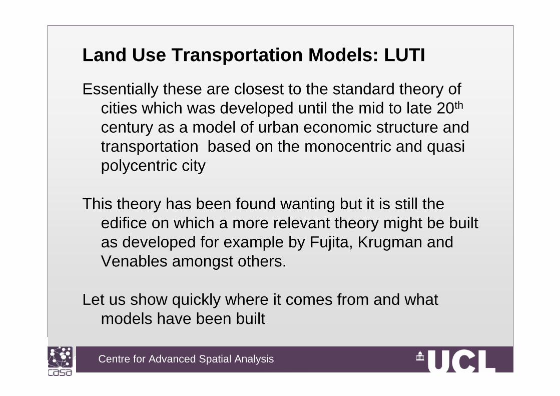
Land Use Transportation Models: LUTI
Essentially these are closest to the standard theory of cities which was developed until the mid to late 20th
century as a model of urban economic structure and transportation based on the monocentric and quasi polycentric city
This theory has been found wanting but it is still the edifice on which a more relevant theory might be built as developed for example by Fujita, Krugman and Venables amongst others.
Let us show quickly where it comes from and what models have been built

Centre for Advanced Spatial Analysis, University College LondonCentre for Advanced Spatial Analysis
Thünen, Johann Heinrich von, (1826) Der isolierte Staat in Beziehung auf
Landwirtschaft und Nationaloekonomie,
Jena : G Fischer, 1910 (1826)
rent
Distancefrom market

Centre for Advanced Spatial Analysis, University College LondonCentre for Advanced Spatial Analysis

Centre for Advanced Spatial Analysis, University College LondonCentre for Advanced Spatial Analysis
Ira S. Lowry (1964) A Model of Metropolis, The Rand Corporation, Santa Monica, CA

Centre for Advanced Spatial Analysis, University College LondonCentre for Advanced Spatial Analysis

Centre for Advanced Spatial Analysis, University College LondonCentre for Advanced Spatial Analysis
IZj
itjtitit XAAA )1(1
reaction diffusion external effect/input
XX X

Centre for Advanced Spatial Analysis, University College LondonCentre for Advanced Spatial Analysis

Centre for Advanced Spatial Analysis, University College LondonCentre for Advanced Spatial Analysis
If I have time I will run this model to show you are far we have come since 1964 – it is on the desktop but we have a web based version too as most software is now delivered this way

Centre for Advanced Spatial Analysis, University College LondonCentre for Advanced Spatial Analysis
Cellular Automata and Agent Based ModelsThe big difference as I will elaborate in more detail in my
paper with Paul Torrens and David O’Sullivan on Saturday I think, is that these CA type models are much less rich in urban theory but essentially dynamic and built from the bottom up
Generically we can see this difference from the reaction-diffusion equation
IZj
itjtitit XAAA )1(1
reaction diffusion external effect/input
X?

Centre for Advanced Spatial Analysis, University College LondonCentre for Advanced Spatial Analysis
Almost as soon as LUTI models were developed, cellular development models appeared on the scene. In 1960, Chapin and Weiss began their work on the development process.
Alan Schmidt built an urban development animation as a precursor to raster based in GIS in 1967 and it is so good it is worth showing
It takes data from the early 19th century on land parcels and prints SYMAP type maps of this at each time stage and then strings them together and uses a movie camera, I guess, to develop the animation as follows:

Centre for Advanced Spatial Analysis, University College LondonCentre for Advanced Spatial Analysis

Centre for Advanced Spatial Analysis, University College LondonCentre for Advanced Spatial Analysis
CA models in fact are based on
• a grid of cells, • a neighbourhood around each cell which is composed of
the nearest cells, • and some rules for how what happens in the
neighbourhood affects the development of the cell in question.
I am not going to repeat what you know – strict CA models lead to emergence as this is the algorithm which generates a self similar structure like a fractal and this works as follows
Most CA models are not strict and do not really show emergence – they are more like GIS models ….

Centre for Advanced Spatial Analysis, University College LondonCentre for Advanced Spatial Analysis
(a) (b) (c)The neighbourhood iscomposed of 8 cells
around the central cell
Place the neighbourhood over each cell on the grid. The rule says that if there
is one or more cells developed (black) in theneighbourhood, then the
cell is developed.
If you keep on doing this for every cell, you get the diffusion from the central cell shown below.
Here is an example of a diffusion process

Centre for Advanced Spatial Analysis, University College LondonCentre for Advanced Spatial Analysis

Centre for Advanced Spatial Analysis, University College LondonCentre for Advanced Spatial Analysis

Centre for Advanced Spatial Analysis, University College LondonCentre for Advanced Spatial Analysis
Greater London
1875 1895 1915 1935 1960 1985 2005
Kiril Stanilov (and mine) West London model developed at the parcel level

Centre for Advanced Spatial Analysis, University College LondonCentre for Advanced Spatial Analysis Kiril Stanilov, March 2010 CASA
1875
2005
Developed using Metronamica, courtest of Engelen and White and RIKS

Centre for Advanced Spatial Analysis, University College LondonCentre for Advanced Spatial Analysis Kiril Stanilov, April 2010 CASA
2005 modeled2005 actual
1875
Stanilov, K. and Batty, M. (2011) Exploring the Historical Determinants of Urban Growth Patterns through Cellular Automata, Transactions in GIS, 15(3), 253–271

Centre for Advanced Spatial Analysis, University College LondonCentre for Advanced Spatial Analysis
The New Short Termism: Fragmentation of Applications & the New Plurality of Planning
My last set of examples are hardly models at all. They are more or less manipulations of big data. The shift that this has occasioned is from the long to the short term
Most of our models look at the long term and the short term – what happens routinely during the day or occasionally but at an instant – has not been subject to much analysis and simulation, with perhaps the exception of time space budgeting and activity modelling in transport
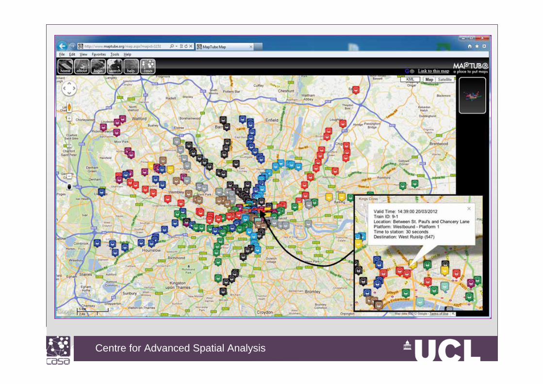
There is now a new focus in mobility and flow at all scales

Centre for Advanced Spatial Analysis, University College LondonCentre for Advanced Spatial Analysis
There has been a major change too to problems that are more immediate – such as crises as well as routine movement. This has come from massive decentralization and a feeling that the long term is less easy to forecast
I could give you an entire lecture on how all of this is beginning to have an impact on a science of cities but what it means for us is that we can model these new problems but they are much more partial than before. In fact CA models are quite well suited to modelling flows which are discrete – in fact some of the new LUTI style models such as MAT Sims are developed in this style.
Let me show some examples and a possible simulation.
Centre for Advanced Spatial Analysis, University College LondonCentre for Advanced Spatial Analysis
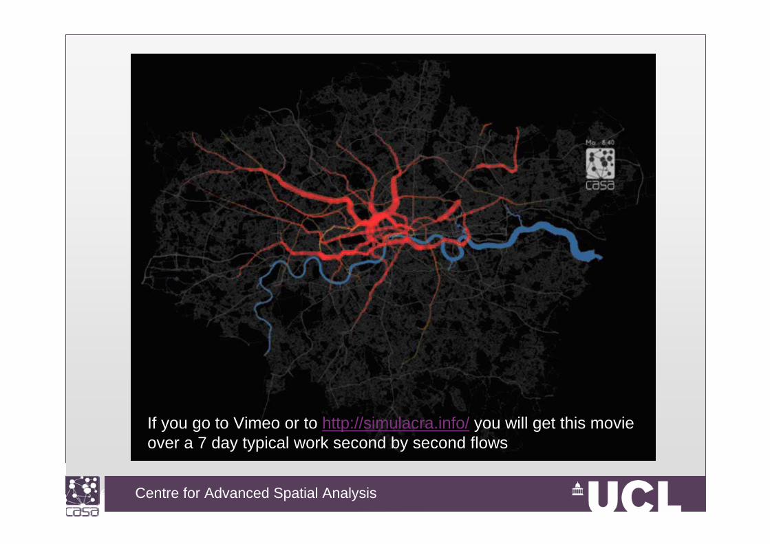
If you go to Vimeo or to http://simulacra.info/ you will get this movie over a 7 day typical work second by second flows
Centre for Advanced Spatial Analysis, University College LondonCentre for Advanced Spatial Analysis

Centre for Advanced Spatial Analysis, University College LondonCentre for Advanced Spatial Analysis

Centre for Advanced Spatial Analysis, University College LondonCentre for Advanced Spatial Analysis
Centre for Advanced Spatial Analysis, University College LondonCentre for Advanced Spatial Analysis
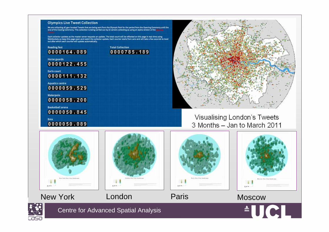
New York London Paris Moscow

Centre for Advanced Spatial Analysis, University College LondonCentre for Advanced Spatial Analysis
Future Prospects
Ok – I have given you a glimpse of where I think we lie in terms of urban modelling
There is little doubt that we are now moving into a world where our focus is much more short term but in time the long term will come to reassert itself as big data from routine transactions begins to mount up and give us change.
Models like UrbanSim and Matsims are key to all this. The science that all this implies is extremely rich but also there is no strong theory to tie it all together

Centre for Advanced Spatial Analysis, University College LondonCentre for Advanced Spatial Analysis
In fact I think there was an assumption 40 years ago when I came into this field that there as a momentum for such a theory of cities and models which would make this applicable.
In fact quite the opposite has occurred – there are signs of theory as for example in new approached to mobility but we do not have new kinds of urban model of a comprehensive nature
The other key development is that urban models do not look at though they will be routinised like GIS – in fact all the applications like MATSIM are tailored to specific applications, the same with Urbansim. SLEUTH for example is not really a model of the same kind.

Centre for Advanced Spatial Analysis, University College LondonCentre for Advanced Spatial Analysis
Moreover policy applications seem to required more elaborate models like Matsims and Urbansim that provide possibilities for partial applications but in the context of a wider simulation.
CA models really cannot do this unless they are linked to suites of models such as the Engelen-White models as they were developed for Murbandy and other projects.
To finish, I think we do stand at a dividing line – where we cannot easily see the way forward – as the age of the comprehensive urban model has passed and now the focus is on tools to build specific models. CA is attuned to this context to an extent but the range of applications is limited.

Centre for Advanced Spatial Analysis, University College LondonCentre for Advanced Spatial Analysis
Resources
Batty, M. (2012) A Generic Framework for Computational Spatial Modelling, Chapter 2 in A. J. Heppenstall, A. T. Crooks, L. M. See and M. Batty, (Editors) Agent-Based Models of Geographical Systems, Springer, Berlin and New York, pp. 19-50.
Our blogs at CASAhttp://blogs.casa.ucl.ac.uk/
My blogshttp://www.complexcity.info/http://www.spatialcomplexity.info/http://www.simulacra.info/ and others that spin off from this
Recommended