OIE Cooperation Project
Capacity development for implementing a Geographic Information System (GIS) applied to surveillance, control and zoning of avian influenza and other emerging avian diseases in China
Parent Reference Laboratory Collaborating Centre for Epidemiology, Training and
Control of Emerging Avian Diseases at Istituto
Zooprofilattico Sperimentale delle Venezie (IZSVe)
Legnaro (PD) - Italy
Candidate Laboratory Chinese Academy of Inspection and Quarantine (CAIQ)
Beijing - China
Annual report

1
Contents
OIE Cooperation Project ......................................................................................................................................
Introduction ....................................................................................................................................................... 1
Background information .................................................................................................................................... 1
Phase 0: Inception Phase ................................................................................................................................... 2
Phase I: Preparatory activities ........................................................................................................................... 2
Phase II: Capacity building ................................................................................................................................. 3
Project changes ................................................................................................................................................. 4
Follow-up ........................................................................................................................................................... 4
List of Annexes ................................................................................................................................................... 5
Introduction The OIE Cooperation Project between the OIE Collaborating Centre for Epidemiology and Training on
Emerging Avian Diseases (IZSVe), Parent Collaborating Centre, and the Chinese Academy for Inspection and
Quarantine (CAIQ), Candidate Collaborating Centre, entitled “Capacity development for implementing a
Geographic Information System (GIS) applied to surveillance, control and zoning of avian influenza and
other emerging avian diseases in China” officially started on 27th October 2014.
The main objective of the project is to allow CAIQ to acquire expertise to implement GIS applications for
surveillance, disease control and zoning. In order to achieve this objective training activities on GIS
management techniques, spatial statistical analyses and spatial models integrated with GIS applications will
be implemented.
GIS can be beneficial to veterinary organisations by providing a means to map their own data and use them
for internal analysis but also to inform other organisations about their activities. In order to organise a
successful GIS platform, it is necessary to integrate a well-designed GIS framework into the organisational
veterinary data management system workflow. The IZSVe and the CAIQ believe that a system that
integrates GIS data with epidemiology and surveillance information, can reduce the complexity of their
analysis (i.e. the biosecurity evaluation for a new candidate quarantine farm), minimise mistakes and
enhance transparency through inter-application operability, communication and cooperation.
Background information Geospatial technology can benefit veterinary services by providing them the ability to map and spatially
analyse their own data. While the use of maps to share information has the potential to become a useful
tool to support surveillance and emergency activities, veterinary services, that simply do not have the
know-how and the required resources to dedicate appropriately trained staff and time to capacity building,
can result unconnected from this growing geospatial community.

2
There is a range of online guidelines and short courses available to individuals and/or organisations wishing
to use GIS and spatial analysis for their projects (such as the series of courses in ArcGIS). Beyond these
standard means, there are also numerous studies and scientific papers available to help users from
veterinary organisations to design and implement their intended mapping activities. However, according to
the experience on GIS, spatial analysis courses, and consultancies acquired by the IZSVe in the last 15 years,
it has been found that standard GIS training offers pay little attention to how veterinary services have to act
in practice in building their GIS and spatial analysis capacity.
This Cooperation Program, designed for technical and managerial staff working at the CAIQ in China, has
the main goal to build the capacity needed to acquire expertise in order to introduce, design and
implement GIS applications for surveillance, disease control and zoning. In particular, the cooperation
program has been modulated to train the Candidate Institute scientists on (i) practical principles on
identification, traceability of live animals, and surveillance (ii) GIS management techniques, and (iii) spatial
statistical analyses and spatial models integrated with GIS applications. All applications and examples refer
to avian influenza and other emerging avian diseases occurring in China.
Soon after the project started in October 2014, a kick-off meeting was held in Beijing (China) with AQSIQ
and CAIQ scientists and top managers (Zhao Zengliang - AQSIQ Deputy Director General, Fang Zhiqiang -
CAIQ Vice President, Dou Shulong - AQSIQ Deputy Director, Jiang Hongqi - Chongqing CIQ Deputy Director).
This meeting highlighted that even if the participants understand the importance of using GIS to perform
their activities, there was little awareness of what a GIS could do and how a GIS office should be organised.
Therefore it was mutually agreed to organise a series of activities to improve both i) the CAIQ management
awareness for developing an effective GIS program to support CAIQ activities, ii) the assessment of the GIS
capabilities of CAIQ.
The first year of activities were entirely dedicated to the two above-mentioned objectives.
Phase 0: Inception Phase The activities performed during the inception phase have been already described in the Interim Report
(Annex 1). One of the elements that emerged during this phase was the difficulty for the CAIQ to acquire
spatial (i.e. farm location in terms of coordinates) and non-spatial (e.g. farm name, species reared)
information about the farm distribution in China and some ancillary background spatial data (e.g. satellite
images, land use).
Phase I: Preparatory activities Phase 1 was dedicated to:
the assessment of the CAIQ GIS capabilities;
the improvement of the GIS awareness among the CAIQ scientists.
In the Interim Report (Annex 1) the results of Activity 1.1 – Collation and search of relevant updated
information and Activity 1.2 – Baseline assessment of CAIQ GIS organisation and capacity - has already been
illustrated.
In the present document it is just highlighted that:
a) In its routinely GIS activities CAIQ performs a risk analysis of the farms under its jurisdiction for the
purpose of disease control and international trade. Spatial considerations (together with good
management and biosecurity plans) play important roles in this analysis. IZSVe and CAIQ scientists
agreed on the fact that these activities are not an application of the Zoning procedure defined
under the provisions of chapter 4.3 of the OIE Terrestrial Code.

3
b) The availability of spatial data in China is very scarce. The attempt made to get in touch with the
Chinese spatial agency (National Administration of Surveying, Mapping and Geoinformation of
China - http://en.nasg.gov.cn/article/Programs/MainProjects/201404/20140400009562.shtml) was
of no avail. The availability of spatial data appears to be one of the major constraints in the
development of the project.
Activity 1.3 Introductory Workshop
Workshop agenda, list of participants, and workshop minutes are presented in the report of the
introductory workshop (Annex 2). All presentations are available on the website
(http://gis.izsvenezie.it/OIE/IZSVe-CAIQ/)
The workshop agenda was drafted according to the approved rationale and the ideas developed during the
kick-off meeting. The aim of the workshop was to present the activities related to the application of GIS
methods in the veterinary field and the tools to be used for zoning and to facilitate an open discussion
among the participants on these topics.
The participants, especially Mr Dou Shulong, AQSIQ Deputy Director, showed great interest in the GIS
technological aspects and particularly on WebGIS. Mr Dou Shulong suggested to refine the cooperation
program activities toward the recently emerged CAIQ needs. After a long discussion the following elements
were proposed:
1. to implement a start-up WebGIS application in order to improve the spatial data accuracy and
capture;
2. to implement a draft procedure to perform a risk analysis of farms under CAIQ jurisdiction, based
on spatial consideration;
3. to refine the capacity building approach on spatial analysis including topics that have a short
term application on CAIQ activities.
Both IZSVe and CAIQ scientists agreed to propose to the OIE the discussed changes of the program, in order
to get the needed approval. An official authorisation to introduce WebGIS application training activities
and to refine the other approved training actions was requested by IZSVe to OIE in November 2015.
Activity 1.4 Assessment of the availability and legal usability of spatial data
Since the very beginning of the project, the spatial data availability was one of the issues investigated by
the CAIQ scientists. The researches revealed that in China the availability of spatial data is very poor. The
CAIQ GIS office was able to purchase a set of data on:
Administrative divisions
Names of administrative divisions
Natural geographic names
Railroads
Street lines
Waterlines
For assessment purposes the above listed data were metadated and added in a IZSVe metadata catalogue
specifically developed for this project (http://gis.izsvenezie.it/OIE/IZSVe-CAIQ/).
Phase II: Capacity building The first part of the Capacity Building phase, was dedicated to the implementation of a training course for
two CAIQ scientists at IZSVe. Due to some problems related to the Visa release from the Italian Embassy in
Beijing, the training shifted almost three months later then the scheduled time (from July 2015 to October
2015 ) .

4
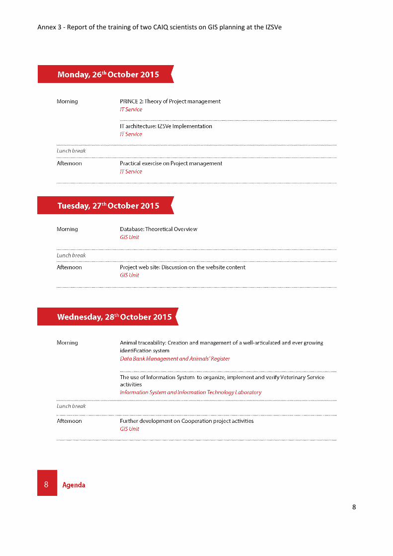
Activity 2.1 Training of two CAIQ scientists on GIS planning at the IZSVe
Training agenda, list of participants and minutes are reported in Annex 3
The training program was drafted according to the approved Activity 2.1, in order to better explore the
feasibility to implement a start-up WebGIS application and a draft risk analysis procedure.
The training course allowed a general increase of GIS awareness and know-how for the two trained CAIQ
scientists. The CAIQ scientists gained a clear idea of what GIS planning is, and in particular of the required
steps and documentations needed for a GIS project, and of the technologies required for developing a
WebGIS start-up. As a material training output, a series of documents for internal GIS planning were
delivered to the participants . The Business Case described in Annex 4 is an example of the documents
produced.
The documentation produced have been used by the CAIQ scientists to support the development a WebGIS
Application. The proposal is under evaluation by the CAIQ managers.
Project changes During the training period, the feasibility to include the proposed changes in the cooperation project was
analysed and the impact evaluated. Both the IZSVe and CAIQ scientists consider the changes feasible and
they agreed to review the budget in order to include an IZSVE expert in the Business planning to support
the development of the WebGIS start-up.
From a practical point of view the following activities have been reformulated:
2.5 Training of two candidate institute scientists on GIS management at the parent institute;
2.6 Training of two candidate institute scientists on GIS analysis at the parent institute;
2.7 Training of four candidate institute scientists on Zoning at the parent institute;
2.8 Editing a conceptual model for developing Zoning areas in China
as follows (amendments are underlined):
2.5 Training of two candidate institute scientists on GIS management and WebGIS techniques at
the parent institute;
2.6 Training of one candidate institute scientist on GIS analysis at the parent institute;
2.7 Training of three candidate institute scientists on development of a GIS system to support the
Zoning activities at the parent institute;
Editing a conceptual model for developing Zoning areas in China and coaching in developing a
WebGIS application.
The documents “Changes between the approved and the new version of the cooperation project.” (Annex
5) report the proposed changes.
Follow-up By end of January 2016 the “Introductory workshop proceedings” (Output 1.3) were completed, revised
and published on the cooperation project web pages.
In January 2016 the CAIQ staff will start the installation, testing and configuration of the “server side” of the
WebGIS application. This coaching phase will end in March 2016 when the IZSVe experts will visit the CAIQ
GIS office.
In March 2016 a meeting in China (presumably in Beijing) will be organised. During the meeting the
following activities will be performed:

5
1. the “client side” of the WebGIS application will be developed by a jointly team formed by the IZSVe
experts and the CAIQ IT staff;
2. the first-cut Zoning related risk analysis framework will be discussed and outlined and a filed test
of the framework will be performed.
In summer (presumably in July 2016) three CAIQ scientists will be trained at IZSVe on the following topics:
a) GIS project study, design and implementation;
b) exploratory spatial data analysis to support the Zoning related risk analysis of farms under CAIQ
jurisdiction;
c) refinement and tuning of the WebGIS application;
d) planning of the training program for local CIQ personnel on GIS and the WebGIS application.
In Autumn (presumably in October 2016) the exploratory spatial data analysis to support the zoning related
risk analysis of farms under CAIQ jurisdiction will be finalised, documented and linked to the WebGIS
application. After the framework release the test and validation procedure of the framework will be
organised.
List of Annexes
1 - First Interim Report (Annexes omitted) 2 - Introductory Workshop report 3 - Report of the training of two CAIQ scientists on GIS planning at the IZSVe 4 - Business Case 5 - Changes between the approved and the new version of the cooperation project 6 - Pictures 7 - Financial report 8 - Revised budget plan

Annex 1 - First Interim Report of the OIE cooperation project IZSVe-CAIQ
OIE Cooperation Project
Capacity development for implementing a Geographic Information System (GIS) applied to surveillance, control and zoning of avian influenza and other emerging avian diseases in China
Parent Reference Laboratory Collaborating Centre for Epidemiology,
Training and Control of Emerging Avian
Diseases at Istituto Zooprofilattico
Sperimentale delle Venezie (IZSVe)
Legnaro (PD) - Italy
Candidate Laboratory Chinese Academy of Inspection and
Quarantine (CAIQ)
Beijing - China
Interim report
29th April 2015

Annex 1 - First Interim Report of the OIE cooperation project IZSVe-CAIQ
1
Document information
Title: Interim Report of the OIE cooperation project IZSVe-CAIQ
Creator: Matteo Morini, Paolo Mulatti, Nicola Ferrè
Date: 13/01/2014
Subject: Interim report
Publisher: Istituto Zooprofilattico Sperimentale delle Venezie - IZSVe (Italy)
Description: Interim Report of the OIE cooperation project IZSVe-CAIQ. It describes the activities performed during the first 6 months of the project.
Relation: OIE cooperation project IZSVe-CAIQ
Identifier: IR_2015.docx
Revisions
Date Author type
20/01/2015 Ferrè Set the doc as deliverable
20/04/2015 Matteo Morini 1st review
25/04/2015 Nadia Micoli 2nd review
28/04/2015 Ferrè Editing

Annex 1 - First Interim Report of the OIE cooperation project IZSVe-CAIQ
2
Introduction
The OIE Cooperation Project between the OIE Collaborating Centre for Epidemiology and Training on
Emerging Avian Diseases at Istituto Zooprofilattico Sperimentale delle Venezie (IZSVe) and the Chinese
Academy for Inspection and Quarantine (CAIQ), entitled “Capacity development for implementing a
Geographic Information System (GIS) applied to surveillance, control and zoning of avian influenza and
other emerging avian diseases in China” officially started on 27th October 2014.
The main objective of the project is to allow CAIQ to acquire expertise to introduce and design GIS
applications for surveillance, disease control, and zoning. To achieve these objectives training activities on
GIS management techniques, spatial statistical analyses and spatial models integrated with GIS applications
have to be implemented.
GIS can be beneficial to veterinary organisations by providing a means to map their own data and use them
not only for internal analysis but also to inform other organisations about their activities. In order to
organise a successful GIS platform, it is necessary to integrate well-designed GIS framework into the
organisational veterinary data management system workflow. IZSVe and CAIQ believe that a system
integrating GIS data, with epidemiology and surveillance data, can hide complexity from users, minimise
mistakes and enhance the transparency through inter-application operability, communication and
cooperation.
Inception phase and preparatory activities
The project inception (activities put into practice before the 27th of November 2014) was dedicated: (i) To
create and define, by means of remote connection tools, the project environment that will be used to
exchange documents and information, (ii) to plan the first mission, (iii) to start the collection of relevant
updated information on Zoning (Activity 1.1).
Project environment implementation
Two elements were tentatively defined for document exchange:
1. A Dropbox folder (Dropbox.com), named “OIE Cooperation project IZSVe – CAIQ”, was created. All the
scientists involved in the project were invited to join this folder. The aim of the folder is to exchange the
final version of public documents.
2. A FTP folder hosted by IZSVe. The IP address of the folder is:
ftp://90.147.123.12/OIE_Coop_IZSVe_CAIQ. The access to this folder can be only by means of user
name and password provided by IZSVe to the project scientists. The aim of this folder is to contain
reserved documents and draft versions.

Annex 1 - First Interim Report of the OIE cooperation project IZSVe-CAIQ
3
A web site was also published. The DNS of the web site is:
http://gis.IZSVenezie.it/tests/OIE/IZSVe-CAIQ/index.php
Figure 1: home page of the cooperation project
At present, the web site consists of only an html page. It will be expanded with documents and information
that OIE, IZSVe and CAIQ will agree to publish.
Activity 1.1 Collation and search of relevant updated information
A bibliographical review was carried out by a search of relevant keywords in well-known literature
repositories, including PubMed, Web of Knowledge, and the OIE websites. The results were further
skimmed by adding definite filters to obtain a core of published papers both to better contextualise the
concept of Zoning in veterinary activities and to clarify the glossary already present in the OIE Terrestrial
Animal Health Code (OIE Code).
A detailed description of the result of activity 1.1 can be founded in annex 1 (Annex 1 – Biblio search)
Activity 1.2 Baseline assessment of CAIQ GIS organisation and capacity
From 22nd to 27th November 2014 the first mission of IZSVe experts to China was carried out to perform a
baseline assessment of CAIQ as far as regard GIS issues are concerned(Activity 1.2). A detailed description
of the activities implemented during the mission can be found in annex 2 (Annex 2 – BTOR meeting
November 2014).
The selection of a workable dataset on surveillance, identification and traceability by CAIQ is still in
progress.
Activity 1.3
The introductory workshop will be jointly organised by IZSVe and CAIQ in May 2015.

Annex 1 - First Interim Report of the OIE cooperation project IZSVe-CAIQ
4
Activity 1.4
In progress: assessment of the availability and legal usability of spatial data.
Enclosed documents
Annex 1 (Bibliographical search)
Annex 2 (BTOR meeting November 2014)
Annex 3 (Financial Report)

Annex 2 – Introductory workshop
OIE Cooperation Project
Capacity development for implementing a Geographic
Information System (GIS) applied to surveillance, control
and zoning of avian influenza and other emerging avian
diseases in China
Introductory Workshop GIS applications to support entry-exit inspection and quarantine activities
GuangZhou (CHN) – 14-15 May 2015
Annex 2 - Introductory workshop
1
LIST OF PARTICIPANTS
Name Department
Mr Qiu Songyin, CAIQ
Mr Chen Ke CAIQ
Mrs Liu Xiaofei CAIQ
Mr Nicola Ferrè IZSVe
Mr Paolo Mulatti IZSve
Mr Andrea Ponzoni IZSVe
Mr Matteo Mazzucato IZSVe
Mr Jiang Hongqi Chongqing CIQ
Mr Liao Jinwan Guangdong CIQ
Mr Xi Xin Zhuhai CIQ
Mr Ji Fan Shenzhen CIQ
Mr Chen Yonghong Guangdong CIQ
Mr Dou Shulong AQSIQ (deputy director)
Ms Li Yijuan AQSIQ (deputy director general)
Mr Fang Zhiqiang CAIQ (vice president)

Annex 2 - Introductory workshop
2
WORKSHOP AGENDA
DAY 1 – 14/05/2015
09:00 – 09:45 Welcome and Introductions
Workshop Goals/Objectives Qiu Songyin
09:45 – 10:45 GIS Management Strategies for entry-exit inspection and quarantine sector
Nicola Ferrè
10:45 – 11:15 break
11:15 – 13:00 GIS Software and applications for an Import/Export Organization
Matteo Mazzucato
13:00 – 14:30 lunch
14:30 – 15:30 GIS analysis for an Import/Export Organization Paolo Mulatti
15:30 – 16:30 The role of the IT infrastructure for GIS applications Andrea Ponzoni
16:30 – 17:30 End of day 1. Discussion on:
“What GIS for entry-exit inspection and quarantine sector”
Moderator:
Qiu Songyin
DAY 2 – 15/05/2015
09:00 – 09:45 Day 1 Wrap-Up Qiu Songyin
09:45 – 10:30 Q&I System for Animals Exported from China Mainland to Hong Kong and Macao
Xi Xin
10:30 – 11:00 break
11:00 – 11:30 Requirements Analysis of Export Livestock Information Management System
Ji Fan
11:30 – 12:30
End of day 2. Discussion on:
“What GIS for entry-exit inspection and quarantine sector [continue]”
Moderator:
Qiu Songyin

Annex 2 - Introductory workshop
3
MISSION REPORT 12th-15thMay 2015
Day 1 Tuesday 12th May 2015 – preliminary meeting
Topics:
- introductory meeting - revision and approval of 1st meeting documents
Participants:
Italy China
Nicola Ferrè, Head of GIS office Liu Xiaofei, CAIQ
Paolo Mulatti, Epidemiological Surveillance, Veterinary
Legislation and Animal Welfare Unit
Qiu Songyin, CAIQ
Andrea Ponzoni, IT manager head of IZSVe IT office
Matteo Mazzucato, GIS technician
Minutes Mr Ferrè informed Chinese colleagues that the Interim report of the project (doc name: Interim report.pdf
– date: 29/04/2015) was submitted to OIE and a positive feedback was provided by Gounalan Pavade
(eMail date: 30/04/2015).
Discussion
Web site
The participants agreed on the importance of a well structured Cooperation Project website. The group
agreed also to increase the quantity of documents published. It was also proposed to improve the home
page with the following menu voices: Home, Project, Participants, Reports, Events, Multimedia.
All the information and documents published in the web site of the project must be approved by both
partners.
The participants hope for an improvement of the web site contents before the beginning of Autumn 2015.
Mr Songyin suggested creating a parallel web site in Chinese language hosted in one of their server linked
from main web site.
Financial matters
Mr Ferrè underlined the importance of keeping the expenditure in line with the approved cooperation
project budget. It is clear that each expenditure must be always attested with an invoice or a receipt. The
eligible expenditure are those included in the approved budget.
Data
Mr Ferrè underlined the importance to collect base maps. He asked Mr Songyin to get in touch with the
National Administration of Surveying mapping and Geo-information (NASG) agency to verify the possibility
to acquire some spatial info.
Annex 2 - Introductory workshop
4
About the spatial analysis
Mr Mulatti renovated the request of selecting a specific researcher to be trained on spatial data analysis.
The selection of the researcher must be done as soon as possible in order to tailor the training materials for
the training period at IZSVe. Moreover, Mr Mulatti has proposed that the type of spatial analysis that will
be offered during the training period at IZSVe will be based on the ESDA techniques and possibly, after a
discussion with the researcher, an upgrade toward more sophisticated techniques will be planned.
About Information Technology
According to Mr Ponzoni it is very important to have an interchange with CAIQ IT experts in order to
identify the current situation and the future trend of CAIQ IT components that will be possible to exploit for
GIS tools and procedures.
About workshop
Mrs Liu Xiaofei suggested to reorganize the workshop agenda of “Day 3” in order to include the
presentation of Mr Xi Xin on the quarantine and inspection procedures for the exported animals from China
mainland to Hong Kong and Macao, and that of Mr Ji Fan on a requirement analysis for the identification of
the core elements for an information system dedicated to the management of the livestock export. The
proposed change was approved by all the participants.

Annex 2 - Introductory workshop
5
Day 2 Wednesday 13th May 2015
Topics: - Visit to a pig farm and a poultry farm in the Guangdong area.
Participants:
Italy China1
Nicola Ferrè, Head of GIS office Liu Xiaofei, CAIQ
Paolo Mulatti, Epidemiological Surveillance, Veterinary
Legislation and Animal Welfare unit
Qiu Songyin, CAIQ
Andrea Ponzoni, IT manager head of IZSVe IT office Mr Chen Ke, CAIQ
Matteo Mazzucato, GIS technician Mr Jiang Hongqi, Chongqing CIQ
Mr Liao Jinwan, Guangdong CIQ
Mr Xi Xin, Zhuhai CIQ
Mr Ji Fan, Shenzhen CIQ
Mr Chen Yonghong, Guangdong CIQ
Minutes The day was entirely dedicated to the visit of two farms that are under AQSIQ supervision in order to show
the farm characteristics (e.g.: dimensions, facilities, etc.), the surrounding environment (e.g.: land use, land
coverage, etc.) and the organisation of the local CIQ offices to the Italian researchers.
The first farm was a pig farm located in the municipality of Baiyun district.
After a presentation of the participants and the preliminary introductory speeches, the farm manager
presented the farm characteristics and briefly described the production cycle in place.
Mr Ferrè briefly explained the role of GIS to support the surveillance and monitoring activities. He
presented a possible usage of the GIS analysis that combine environment characteristics, wildlife
presence and surrounding farms distribution as a tool to describe the area where the farms under
AQSIQ supervision are located. A brief discussion about the disease early warning system managed by
Ministry of Agriculture and the availability of maps useful to support GIS activities took also place.
Furthermore, during the visit some issues about the traceability of pigs were discussed.
Another topic discussed was the inspection activities made by the CAIQ personnel.
In the afternoon the visit continued to a poultry farm located in the municipality of Panyu district.
After a presentation of the participants and the preliminary introductory speeches, the farm manager
presented the farm characteristics and briefly described the farm activities. He also informed the
participants that an IT system was in place in order to manage information related to the restocking
program, vaccination, etc.
Mr Ferrè briefly described the OIE zooning and compartmentalisation process and also how the GIS can
be used to support those processes.
1 In this table only the people directly involved in the OIE cooperation project mission are listed. The CAIQ personnel
that accompanied the team, as well as the farms personnel, are not mentioned.

Annex 2 - Introductory workshop
6
Day 3 Thursday 14th May 2015
Topics: - Workshop first part – topic presentation
o Title: CAIQ and IZSVe OIE cooperation project - introductory workshop. o Goal: to present activities related to GIS methods and the tools to be used for surveillance,
control and zoning of Avian Influenza and other emerging avian diseases in China in order to improve GIS awareness.
Participants Italy China
Nicola Ferrè, Head of GIS office Dou Shulong
Paolo Mulatti, Epidemiological Surveillance, Veterinary
Legislation and Animal Welfare unit
Liu Xiaofei, CAIQ
Andrea Ponzoni, IT manager head of IZSVe IT office Qiu Songyin, CAIQ
Matteo Mazzucato, GIS technician Mr Chen Ke, CAIQ
Mr Jiang Hongqi, Chongqing CIQ
Mr Liao Jinwan, Guangdong CIQ
Mr Xi Xin, Zhuhai CIQ
Mr Ji Fan, Shenzhen CIQ
Mr Chen Yonghong, Guangdong CIQ
Minutes The workshop has been organised in the framework of Phase 1 (Preparatory activities) of the CAIQ-IZSVe
OIE cooperation project..
Morning In the morning session the following presentations were delivered:
Mr Ferrè - GIS Management Strategies for entry-exit inspection and quarantine sector
Mr Mazzucato - GIS Software and applications for an Import/Export Organization
Discussion - morning Mr Dou emphasized the importance of a GIS strategic plan for defining strategic goals and initiatives to
enhance geospatial functionality, services and strategy for a large organisation like CAIQ. Mr Dou also
emphasised the importance of efficiently managing data to improve their reuse.
Mr Ferrè highlighted the concept of the IT infrastructure as a way to organise spatial and non spatial
information. The dimension of the infrastructure depends on the type and amount of investments (both in
terms of human and technical resources) programmed.
Afternoon In the afternoon session the following presentations were made:
Mr Ponzoni The role of the IT infrastructure for GIS applications
Mr Mulatti GIS analysis for an Import/Export Organization
Mr Xi Xin Quarantine & Inspection system for animals exported from China mainland to
Hong Kong and Macao
Mr Ji Fan Requirements analysis of export livestock – information management system.

Annex 2 - Introductory workshop
7
Discussion - afternoon. Mr Dou emphasized the importance of GIS as a very useful tool for supporting (i) surveillance activities, (ii)
food safety programmes (iii) and risk communication. Especially the last feature could play an important
role for the CAIQ activities.
Mr Ferrè reminded the fact that GIS needs data. GIS has the ability to combine spatial and non-spatial data
and create a data warehouse useful not only for map producing but also for generating “classical”
information like tables, graphs etc..
The discussion continued with speculation about the data quality and data harmonisation and the
challenges that an organisation like CAIQ could face to gain a well organised data warehouse.

Annex 2 - Introductory workshop
8
Day 4 Friday 15th May 2015
Topics: - Workshop second part – discussion
o Title: CAIQ and IZSVe OIE cooperation project - introductory workshop. o Goal: to present activities related to GIS methods and the tools to be used for surveillance,
control and zoning of Avian Influenza and other emerging avian diseases in China in order to improve GIS awareness.
Participants Italy China
Nicola Ferrè, Head of GIS office Ms Li Yijuan, AQSIQ
Paolo Mulatti, Epidemiological Surveillance, Veterinary
Legislation and Animal Welfare unit
Mr Dou Shulong, AQSIQ
Andrea Ponzoni, IT manager head of IZSVe IT office Mr Fang Zhiqiang, CAIQ
Matteo Mazzucato, GIS technician Liu Xiaofei, CAIQ
Qiu Songyin, CAIQ
Mr Chen Ke, CAIQ
Mr Jiang Hongqi, Chongqing CIQ
Mr Liao Jinwan, Guangdong CIQ
Mr Xi Xin, Zhuhai CIQ
Mr Ji Fan, Shenzhen CIQ
Mr Chen Yonghong, Guangdong CIQ
Minutes The second day of the workshop started with the self introduction of the participants, followed by a
presentation that resumed the main points presented the day before made by Qiu Songyin.
Discussion Mr Ferrè recalled the ideas of the OIE project and the importance of the capacity building for developing an
effective GIS for an organisation like the CAIQ. Mr Ferrè described the progress made during the
cooperation activities and the importance of the previous mission where the assessment exercise was
carried out.
Mr Dou elucidated the importance of developing an effective GIS to manage information useful for
supporting the CAIQ activities. Mr. Dou recognised that the CAIQ needs some capacity building actions to
improve the functionalities developed by their GIS office.
The discussion continued with some speculation on the importance of organising a well structured strategy
to design and to implement GIS applications. In particular the IZSVe researchers pointed out that an
approach based on project management techniques should be taken into account by the CAIQ colleagues.
Mr Dou observed that CAIQ has some IT applications already in place that must be, in some way, integrated with the GIS to facilitate the decision making processes. He suggested to consider the exchange of knowledge that will take place during the Cooperation Project as an opportunity to understand the IZSVe GIS organizational model and try to grasp from them the most useful solutions for CAIQ. In particular Mr Dou appreciated the leanings adopted by the IZSVe technicians based on Open Source tools as a way to
limit costs for implementing GIS solutions.
Annex 2 - Introductory workshop
9
About the idea of integrating GIS technology into the CAIQ frameworks, Mr Ferrè highlighted the
importance of a well defined change in the management strategy and these changes should be supported
by the CAIQ decision makers. Moreover, the CAIQ management should consider that some of their
resources should be prepared to face the challenge that GIS technologies present.
Mr Dou agreed with the concept explained by Mr Ferrè and remarked the importance of achieving some
results from GIS technologies in the near future. Therefore, he asked the IZSVe team to start with some
practical activities in order to implement some GIS functionality and to integrate them into CAIQ
frameworks.
Following the request of Mr Dou, the discussion speculated on the possible scenarios that could be
implemented in the next future by CAIQ, in particular two different scenarios were depicted:
1. A stand-alone system based on desktop applications where a GIS software combines different
spatial and non-spatial information in order to provide maps and analysis useful to support the
required activities.
2. A webGIS application dedicated to collect and publish spatial and non-spatial information. Desktop
applications should be designed to derive maps and analysis useful to support the required
activities. The webGIS can also be used to publish the derived maps that could be used to inform
foreign countries about the production sites.
Mr Ferrè highlighted that both solutions require background maps. He suggested to CAIQ to get in touch
with the National Administration of Surveying mapping and Geo-information (NASG).
About the idea to develop the webGIS scenario, Mr Ferrè informed the CAIQ colleagues that the
development of this technology was not included in the Cooperation Project and therefore it should be
asked to OIE if it is possible to introduce it and, eventually, how it should be done.
Mr Fang considered the discussion developed during the workshop very useful for the CAIQ scientists and
gave him the opportunity to see the high expertise on GIS matters of the Italian partners. After this
workshop he considered that a good level of reciprocal understanding was reached. Moreover, he
considered that GIS is a very important tool to support the decision making process and he hopes that CAIQ
will be able to promote its usage GIS in all China and in the neighbouring countries.
Mrs Li thanked all the participants for the effort put in the workshop. She expressed the opinion that the
passion and the competence put by both the Italian and Chinese scientists were impressive. She hoped that
the workshop would allow the CAIQ to better understand the required elements to develop successful GIS
application. She considered GIS technologies really important for supporting the CAIQ and AQSIQ activities
regarding the export and import programs.
Annex 3 – Report of the training of two CAIQ scientists on GIS planning at the IZSVe
OIE Cooperation Project
Capacity development for implementing a Geographic
Information System (GIS) applied to surveillance, control
and zoning of avian influenza and other emerging avian
diseases in China
Training of two CAIQ scientists on GIS planning at the IZSVe – October 2015

Annex 3 - Report of the training of two CAIQ scientists on GIS planning at the IZSVe
1
INFORMATION TO PARTICIPANTS AND TRAINING AGENDA

Annex 3 - Report of the training of two CAIQ scientists on GIS planning at the IZSVe
2

Annex 3 - Report of the training of two CAIQ scientists on GIS planning at the IZSVe
3

Annex 3 - Report of the training of two CAIQ scientists on GIS planning at the IZSVe
4

Annex 3 - Report of the training of two CAIQ scientists on GIS planning at the IZSVe
5

Annex 3 - Report of the training of two CAIQ scientists on GIS planning at the IZSVe
6

Annex 3 - Report of the training of two CAIQ scientists on GIS planning at the IZSVe
7
Annex 3 - Report of the training of two CAIQ scientists on GIS planning at the IZSVe
8

Annex 3 - Report of the training of two CAIQ scientists on GIS planning at the IZSVe
9

Annex 3 - Report of the training of two CAIQ scientists on GIS planning at the IZSVe
10
MINUTES Training of two CAIQ scientists on GIS planning at the IZSVe – October 2015
Meeting venue Location: IZSVe headquarter, Legnaro (PD), Italy
Flight schedule and transfer CAIQ experts Departure: Beijing airport – 17/10/2015
Arrival: Venice airport – 18/10/2015
Departure: Venice airport – 31/10/2015
Arrival: Beijing airport – 01/11/2015
Participants
CAIQ IZSVe
QIU SONGYIN - VETERINARIAN NICOLA FERRÈ – GIS MANAGER
JI FAN - VETERINARIAN PAOLO MULATTI - VETERINARIAN
ANDREA PONZONI – IT MANAGER
MATTEO MAZZUCATO – GIS TECHNICIAN
MATTEO TROLESE – DBA
MONICA LORENZETTO – GIS ANALYST
GRAZIA MANCA – VETERINARIAN
LAURA BORTOLOTTI - VETERINARIAN
Introduction With the training of two CAIQ scientists on GIS planning at the IZSVe the cooperation program enters phase
2, the capacity building phase. This is the most important phase of the program as the CAIQ scientists will
be trained in GIS planning essential elements in order to allow them to develop a GIS project in a coherent
and structured way in their home country.
During the workshop held in May 2015 in Guangdong (CHN), emerged the need from CAIQ scientists to
refine the cooperation program. In particular, it was proposed to consider, as a Use Case1 to implement a
GIS plan, the development of a WebGIS application to support the Zoning activities. Following this request,
Activity 2.1 “Training of two CAIQ scientists on GIS planning at the Parent Institute”, was designed to
transpose the theoretical aspects of GIS management and spatial analysis into the idea of developing a
1 A Use Case expresses a contract between the stakeholders of a system about its behaviour. It describes the system’s
behaviour and interactions under various conditions

Annex 3 - Report of the training of two CAIQ scientists on GIS planning at the IZSVe
11
system that includes a WebGIS application and some temptative framework for the data capture and
spatial analysis. In particular, for the planned activity of 2.1.2 more emphasis was put on the practical
example of “Setting up a GIS laboratory” activity (45% of the total amount of time) with respect to the
theoretical aspects presented during the “advanced GIS and ESDA” and “Introductory GIS components”
activities (respectively 25% and 30% of the total amount of time).
, the training included the presentation and discussion of theoretical aspects of a given issue in the
morning (i.e. WebGIS configuration, ESDA, etc.), while the related practical activities were performed by
the two CAIQ scientists supported by IZSVe experts in the afternoon. The results of the afternoon jointly
practical activities are a series of documents useful to the design, develop and implement a system for the
management of the spatial information of farms dedicated to the import/export of live animals in China.
The training was designed according to the project management aspects defined by the PRINCE 2 methods
(https://www.axelos.com/best-practice-solutions/prince2).
Day 1 - Monday 19th October 2015 – Preliminary meeting Topics:
- introductory meeting - revision and approval of the workshop minutes - further activities of cooperation program
Participants:
CAIQ IZSVe
QIU SONGYIN - VETERINARIAN NICOLA FERRÈ – GIS MANAGER
JI FAN - VETERINARIAN PAOLO MULATTI - VETERINARIAN
ANDREA PONZONI – IT MANAGER
MATTEO MAZZUCATO – GIS TECHNICIAN
Minutes Mr Ferrè presented the training program describing the last adjustments on the agenda. The program was
approved by the participants.
Mr Ferrè introduced the concept of the project web site. He asked to the participants to propose some
actions to develop the web pages.
Mr Mazzucato proposed to publish the documents already sent to OIE both in a PDF form and in a HTML
format (for some of them) in order to navigate on them.
The idea was approved and, moreover, it was asked to Mr Mazzucato to prepare a program about the
implementation of HTML pages.
About the spatial data availability in China Mr Songyin informed IZSVe staff, he got in touch with the
Chinese spatial agency, but unfortunately no spatial data was available. The participants agreed on keep
monitored the GIS community channels in order to grasp any potential news on spatial data availability in
China.

Annex 3 - Report of the training of two CAIQ scientists on GIS planning at the IZSVe
12
According to the outcomes of the workshop held in May 2015, Mr Songyin asked to refine the cooperation
program activities in order to introduce the development of a WebGIS application as a practical application
of the GIS management theories.
Mr Ferrè informed Mr Songyin that the training program of the next two weeks was tailored to follow the
request emerged during the workshop but the modification of the cooperation program according to the
Chinese requests should be approved by OIE.
Mr Ferrè informed the participants that he will get in touch with the OIE referent to present the request of
introducing the WebGIS practical and theoretical aspects into the cooperation program.
Mr Ferrè suggested to speculate on the possible impact that the introduction of the WebGIS development
study will have on the cooperation program activities. After the discussion a list of possible impacts was
identified. This analysis will be reviewed by Mr Ferrè, Mr Mulatti and Mr Mazzucato after the two-week
training.
From day 2 to day 10 (20th – 30th of October 2015)
Topics: Training of the two CAIQ scientists on:
GIS management and project planning
WebGIS development
Explorative Spatial Data Analysis (ESDA) for Zoning
Enterprise database design and development
Data bank management system
Information system to support veterinary activities
Participants:
CAIQ IZSVe
QIU SONGYIN - VETERINARIAN NICOLA FERRÈ – GIS MANAGER
JI FAN - VETERINARIAN PAOLO MULATTI – VETERINARIAN
ANDREA PONZONI – IT MANAGER
MATTEO MAZZUCATO – GIS TECHNICIAN
MATTEO TROLESE – DBA
MONICA LORENZETTO – GIS ANALYST
GRAZIA MANCA – VETERINARIAN
LAURA BORTOLOTTI - VETERINARIAN
Minutes The training activities were organised in the following way:
Morning session: theoretical aspects on a specific training subject.
Afternoon session: the CAIQ scientists developed the assigned activities supported by the IZSVe
experts.

Annex 3 - Report of the training of two CAIQ scientists on GIS planning at the IZSVe
13
The first part of the training focused on project planning using a revised version of the PRINCE2 (Projects IN
Controlled Environments) business case method. The outcome of this phase was a Business case document
(written both in English and Chinese) dedicated to the development of a system to support the
management of GIS activities related to (i) the supervision of farms that export animals to Hong Kong and
Macao, and (ii) the certification of quarantine farm (Annex 4_Business Case).
The next phases were dedicated to the As-Is analysis, functional requirement analysis and gap analysis. By
using the Use Case technique, the As-Is analysis was developed in order to describe the system in place at
the AQSIQ – CAIQ for the management of the spatial information of the quarantine farm. aAn As-Is analysis
document was developed. The next step was the development of a first-cut functional analysis of the
envisaged system. The result of this analysis was a functional requirement analysis document and a gap
analysis document.
The final part of the training was dedicated to the discussion on the possible spatial analysis for supporting
the CIQ Zoning tasks.

Annex 4 – Business case
1
MOE WebGIS
(WebGIS for Management of export farms)
project proposal for the development of a system for the management
of the CAIQ GIS activities
出口活动物 WebGIS
地理信息技术管理系统项目建议
Description
This is a project proposal for the development of a system to support the
management of GIS activities related to (i) the supervision of farms that export
animals to Hong Kong and Macao, and (ii) the certification of quarantine farms.
The envisaged system is based on a WebGIS tools dedicated to the data
collection and validation integrated with a series of framework. These tools are
related to the implementation of the risk analyses associated with the evaluation
of the candidate farm to become a quarantine or export farm (a single system to
manage different processes).
The main outcome of the project is to create a system that allows the local CIQ to
collect the spatial information of a candidate farm and other related information
(i.e. name, address, specie, etc.) by using a computing system that stores the
information in an enterprise database and controls the flow of data entry
process.
The system includes also a series of framework dedicated to the risk analysis of
the candidate farm based on GIS tools available in any GIS software and some
functionality useful for the traceability of exported animal.
项目描述:
此项目建议书为开发基于地理信息技术的出口农场监管及进口隔离场审核
计算机管理系统提供支持。
该系统设想基于 WebGIS 工具来收集和验证一系列来自出口农场及进口隔
离场的用于实施风险分析的数据。
该项目的主要产出是创建一个可以让 CIQ 收集相关农场注册信息及空间信
息的计算机系统,并将这些信息储存于数据库、管理数据流。
该系统包含一系列基于 GIS 工具进行风险分析的框架以及部分可应用于出
口动物追溯的功能。
Annex 4 – Business case
2
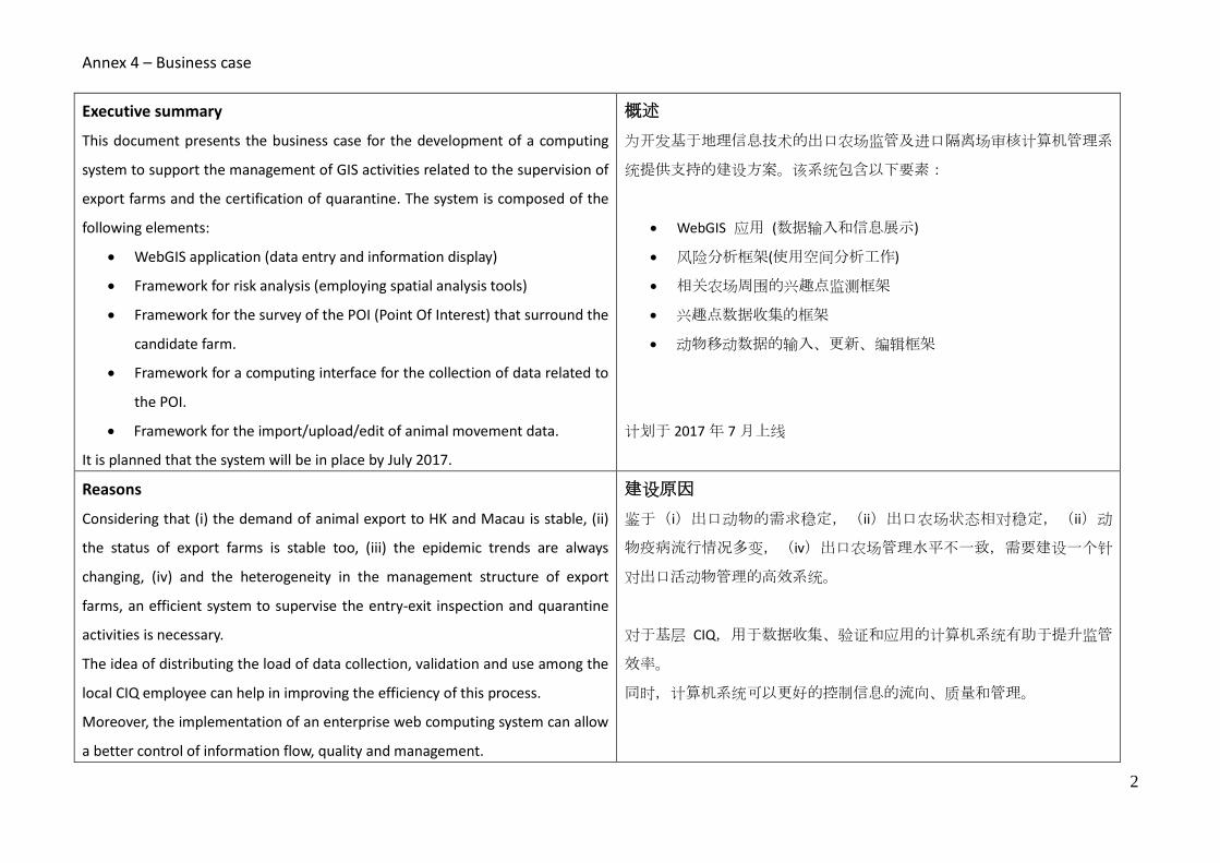
Executive summary
This document presents the business case for the development of a computing
system to support the management of GIS activities related to the supervision of
export farms and the certification of quarantine. The system is composed of the
following elements:
WebGIS application (data entry and information display)
Framework for risk analysis (employing spatial analysis tools)
Framework for the survey of the POI (Point Of Interest) that surround the
candidate farm.
Framework for a computing interface for the collection of data related to
the POI.
Framework for the import/upload/edit of animal movement data.
It is planned that the system will be in place by July 2017.
概述
为开发基于地理信息技术的出口农场监管及进口隔离场审核计算机管理系
统提供支持的建设方案。该系统包含以下要素:
WebGIS 应用 (数据输入和信息展示)
风险分析框架(使用空间分析工作)
相关农场周围的兴趣点监测框架
兴趣点数据收集的框架
动物移动数据的输入、更新、编辑框架
计划于 2017 年 7 月上线
Reasons
Considering that (i) the demand of animal export to HK and Macau is stable, (ii)
the status of export farms is stable too, (iii) the epidemic trends are always
changing, (iv) and the heterogeneity in the management structure of export
farms, an efficient system to supervise the entry-exit inspection and quarantine
activities is necessary.
The idea of distributing the load of data collection, validation and use among the
local CIQ employee can help in improving the efficiency of this process.
Moreover, the implementation of an enterprise web computing system can allow
a better control of information flow, quality and management.
建设原因
鉴于(i)出口动物的需求稳定,(ii)出口农场状态相对稳定,(ii)动
物疫病流行情况多变,(iv)出口农场管理水平不一致,需要建设一个针
对出口活动物管理的高效系统。
对于基层 CIQ,用于数据收集、验证和应用的计算机系统有助于提升监管
效率。
同时,计算机系统可以更好的控制信息的流向、质量和管理。

Annex 4 – Business case
3
Expected benefits
Improve the management and supervision of the animal export in the
farms.
Improve the quality of data used in the process.
The flow of animals and the related information are made synchronous
Make supervision work more transparent and efficient.
Preliminary implementation of zoning approach for the exporting farms.
Develop a group of GIS users also at local level.
预期收益
提升出口动物的分级分类管理水平
提升数据质量
实现货物流与信息流的同步传导
使监管工作更加透明高效
初步实现出口农场动物疫病区域化管理
培养一批 GIS应用专家
Expected pitfalls
Need a certain period of time to change the traditional management and
supervision mode.
Need to build up an extra user service to run the application smoothly
and solve problems in using the new system.
Some IT resources are necessary to implement and maintain the system.
负面提醒
改变传统管理方式需要一定适应期
需要建立客服支持系统顺利运行,解决系统使用的各类问题
需要 IT 团队运行和维护系统
Business options
The proposed system has been studied to replace the currently framework in
place. This solution is based on (i) a set of operations governed by a GIS
technician, (ii) made at central level, (iii) that use a series desk top software. Up
to now, this framework is able to guarantee the process load but it presents
some pitfalls such as (i) the difficulties to keep the POI update, (ii) the GIS
technician became more and more overcommitted, and (iii) the usage of
personal database that do not allow an efficacy data management.
In this proposal the adoption of Open source/Open license software allows the
备选方案
研究了另一种替代现行方案的系统,替代解决方案基于在中央层级开发的
由 GIS 专家支配的一整套操作,并使用一系列桌面软件。目前,这种框架
可以确保流程的质量,但是存在缺点,例如保持 POI 的更新相对困难,
GIS 专家工作量大,个人数据库的使用无法实现高效的数据管理。
同时,在技术解决方案上,现行方案使用开源软件,可以减少项目预算

Annex 4 – Business case
4
exclusion of the software cost in the project budget (only the cost for the system
implementation and application development remains and this is the same
amount for any kind of software solution adopted [i.e. ESRI ArcGIS Server]).
(只有系统开发成本,此类开发成本与任何一种软件解决方案的开发成本
一致)
Timescale(See Business Case Timescale”)
The proposed project has a time length of 18 months (starting from the 1st of
January 2016). For a detailed task Gantt diagram, please refer to the document
for the system scale.xlson
进度表(见“Business Case Timescale”)
该项目预计持续 18 个月(自 2016 年 1 月 1 日开始)。详见“详见 6 计持
续 imescale Case Timescale”
Cost CNY Man-month 成本 经费 人力 -
月
Personal
The basic idea is to employ AQSIQ personnel for the
implementation of the system supported by the
IZSVe experts (OIE cooperation program). These
activities regard:
Definition of the framework for the system
operability
Testing the system
Input of the required data
Development of a start-up WebGIS application
0 8 人员
在 IZSVE 支持下,质检总局派员完成系统建设
(OIE 合作项目)。包括:
系统框架确认
系统测试
需求数据输入、
开发 WebGIS 应用
0 8
Maintenance
The system maintenance
1. internet IP address (cost per year)
2. data backup (cost per year)
30,000
30,000
维护费用
两类维护费用:
1. 租用 IP(每年费用)
2. 数据备份(每年费用)
30,000
30,000

Annex 4 – Business case
5
3. IT personnel (i.e. data backup, infrastructure
monitoring, support the users, etc.) (cost per
year)
2 3. IT 员工(如数据备份、基础建设、运行、用户
支持等)
2
Hardware
It is planned to exploit the hardware already in use
at AQSIQ (i.e. server, pc, GPS, etc.), in any case some
cost should be considered in the next years (i.e. 3
years) for the replacement of obsolete components.
0
0
硬件
计划利用现有硬件(如服务器、电脑、GPS
等),未来(3 年)可能有部分设备更新成本。
0 0
Software
The software identified for the system
implementation is Open source/open license
software, therefore no cost for its acquisition is
computed.
0
0
软件
使用开源软件,无采购成本
0 0
Programming – application development
The development of the system requires that a
company is in charge to develop the application
according to the specification defined by the AQSIQ
personnel supported by the IZSVe experts (OIE
cooperation program). The cost shall include:
1. Development, installation and testing
2. Ordinary maintenance (cost per year)
3. Extraordinary maintenance (cost per year)
150,000
30,000
60,000
(per
year)
1
应用开发
开发系统需要公司来开发应用,开发过程由质
检总局进行指导并从 IZSVe 获取支持(OIE 合作
项目)。成本包括
1. 开发、安装、测试
2. 常规维护(每年经费)
3. 特别维护(每年经费)
150,000
30,000
60,000
(per
year
)
1

Annex 4 – Business case
6
Training course
Cost for training on WebGIS usage and frameworks
implementation
50,000
1
培训
WebGIS 工具应用及系统使用培训
50,000
1
Total cost for the first year 410,000 第一年成本总计 410,000
Total cost for the following years 150,000 后续成本 150,000
Investment appraisal
Reduce administrative costs
Reduce enterprise operating costs
投资评价
节约行政成本
减少企业日常管理成本
Major risks
Changes of personnel in the future (technicians and manage experts of
GIS)
No stationary and special funds for GIS project.
主要风险
未来可能发生的人员(技术及管理专家)变动
没有固定的专项资金投入 GIS 软硬件开发建设
Activities
The list of activities and the related time sequence are presented in the Gantt
diagram. It is worth to mention that some activities are scheduled according to
the OIE cooperation project and the IZSVe experts agenda. A full description of
the below listed steps is presented in the requirement analysis document
(Requirement Analysis.docx)
任务
任务列表及时间安排参见进度表。部分任务依据 OIE 合作项目及 IZSVe 议
程进行安排。下表中的完整描述可参见需求分析报告(Requirement
Analysis.docx)

Annex 4 – Business case
7
1. Project approval
2. Build up the system conceptual model. The conceptual model, derived from
the requirement analysis, defines the IT components and the IT interface for
the subsequent IT executive project development step.
3. WebGIS application executive project. With this document all the WebGIS
specifications are defined in order to allow the application developer to
develop a program according to the requirement analysis.
4. Database development. A database and the related schemas are developed,
tested and populated with the core data.
5. WebGIS application development.
6. GIS frameworks development, testing and implementation.
7. Define a pilot project for the zoning framework. The above mentioned
frameworks allow the AQSIQ personnel to implement a zone analysis around
quarantine or exporting farm. The main goal of the pilot project is to evaluate,
in an full operational environment, the capacity of the entire system (WebGIS
+ GIS frameworks).
8. Training local CIQ personnel for the implementation of developed system.
1. 项目批准
2. 建模。模型源自需求分析,为之后执行项目开发定义 IT 组件和界面。
3. WebGIS 应用执行项目. 确认 WebGIS 细节,确保应用开发者根据需求
分析进行项目开发。
4. 数据库开发。开发数据库及相关概要,用核心数据测试并填充
5. 开发 WebGIS 应用。
6. 开发 GIS 框架,测试并投入使用。
7. 确认区域化管理试点项目。上述框架的建设是 AQSIQ 员工可以对出口
农场及隔离场进行区域分析。试点项目主要目的是评估在一个完整的
可操作的环境中整个系统的能力。(WebGIS+GIS 框架)
8. 培训 CIQ 员工使用开发完成的系统。

Annex 4 – Business case
8
Roles and responsibilities
Executive:Lin Xiangmei
Superuser:Dou Shulong
Senior supplier :TBD
Project Manager:Qiu Songyin
Team Leader
WebGis team:Qiu Songyin
Framework Team:Ji Fan
Policy team:Ji Fan
IT team:Chen Ke
责任分工
项目执行:林祥梅
超级用户:窦树龙
高级支持:待定
项目管理:仇松寅
团队负责人
WebGIS 组:仇松寅
框架组:纪帆
政策组:纪帆
IT 组:陈克
Stakeholders
AQSIQ:General Administration of Quality Supervision, Inspection and
Quarantine.
CIQ:CAIQ official authorities that are present at different provinces who
are in charge to collect the information on export farms and supervise them.
Vendors and managers of export farms:People who own the export farms
and manage the process of raising the export animals
Ministry of Agriculture of PRC:Official authority that is responsible for
national farm management.
Food and Environmental Hygiene Department of HK:The official authority
in charge of the import animals products in HK.
Agriculture, Fisheries and Conservation Department of HK:The official
authority in charge of the import animals in HK.
潜在用户
国家质检总局:对出口活动物进行宏观管理的官方机构
检验检疫局:分布于不同省份负责收集农场信息并进行监管的官方机
构
出口农场拥有者及管理者:拥有农场的人,管理饲养全程的人
农业部:管理全国范围内农场的官方机构
食环署:负责香港进口动物且关注原农场监管

Annex 4 – Business case
9
The Official Provisional Municipal Council of Macau:The official authority
in charge of the import animals in Macau who focus on the management of
animals on the original farms in mainland.
香港渔护署:负责香港进口动物且关注原农场监管
澳门民政总署:负责澳门进口动物且关注原农场监管
Credits This document has been produced under the OIE Cooperation Project Capacity development for implementing a Geographic Information System (GIS) applied to surveillance, control and zoning of avian influenza and other emerging avian diseases in China
Authors
Qiu Songyin - Chinese Academy of Inspection and Quarantine
Ji Fan - Shenzhen Entry-Exit Inspection and Quarantine Bureau
Nicola Ferrè - Istituto Zooprofilattico Sperimentale delle Venezie

Annex 5 - Changes between the approved and the new version of the cooperation project
1
Changes between the approved and the new version of the cooperation project
Activity 2.3.Training of all the relevant CAIQ staff – Basic GIS course
This activity has been postponed after Activity 2.8. and modified as ”Training of all the relevant CAIQ staff – GIS and webGIS course” Activity 2.5 Training of two Candidate Institute scientists on GIS management at the IZSVe
Parent Institute
In this activity the webGIS task is introduced. This new task has been expressively requested by the Candidate Institute in order to support in a more professional way their process for Zoning analysis. In particular, in this activity a new bullet point has been added (Training on webGIS study, design and implementation), and the expert that will be hired to support the metadata analysis will be also involved in the webGIS development.
Comparison
Approved version New version
Activity 2.5 Training of two Candidate Institute scientists on GIS management at the IZSVe Parent Institute A training on GIS management will be implemented in order to train two Candidate Institute scientists as GIS manager. The training will last one week and will follow a tight agenda of theoretical lessons and discussions on the steps and the technical components necessary for implementing a GIS system. In particular, the training will provide notions on building laboratory capacity on procedures and methods for planning the GIS, evaluating potential data sources, testing available hardware and software and planning for its acquisition, building the GIS data base, developing GIS applications, and planning for long term maintenance of the GIS system and data base.
Training content The training course will be based on the following themes: • Setting project goals and objectives. • Developing GIS policies and procedures. • Coordinating GIS planning and analysis. • Designing and implementation of organization GIS
standards or structured frameworks. • Planning, setting and tracking GIS-related budgets. • Monitoring performance against plans and
establishing resolution actions for any variances from plans.
• Supervising, monitoring and evaluating the work of
Activity 2.5 Training of two Candidate Institute scientists on GIS management at the IZSVe Parent Institute A training on GIS management will be implemented in order to train two Candidate Institute scientists as GIS manager. The training will last one week and will follow a tight agenda of theoretical lessons and discussions on the steps and the technical components necessary for implementing a GIS system. In particular, the training will provide notions on building laboratory capacity on procedures and methods for planning the GIS, evaluating potential data sources, testing available hardware and software and planning for its acquisition, building the GIS data base, developing GIS applications, and planning for long term maintenance of the GIS system and data base.
Training content The training course will be based on the following themes:
Setting project goals and objectives.
Developing GIS policies and procedures.
Coordinating GIS planning and analysis.
Designing and implementation of organization GIS standards or structured frameworks.
Planning, setting and tracking GIS-related budgets.
Monitoring performance against plans and establishing resolution actions for any variances from plans.
Supervising, monitoring and evaluating the work of

Annex 5 - Changes between the approved and the new version of the cooperation project
2
GIS staff. • Recommending and, where appropriate,
developing GIS and related training programmes. • Coordinating and leading GIS initiatives with
external organizations. • Evaluating technological advances and promoting
the usage of appropriate technology and application.
• Training on metadata and catalogue service, software installation and tuning on the available server.
More specifically and with reference on the last bullet point, metadata is a detailed description of the contents and quality of a data set and an important building block in every GIS infrastructure. Metadata allows the user to discover whether an information resource exists, who owns and distributes it, where it is located, what are the conditions for its use and whether it is fit for the intended purpose by the user. A Metadata Catalogue is the web service that allows the publication of the metadata record-set. The technology on Metadata Catalogue is constantly upgraded. Experts on this filed are able to provide insight on new functionalities, future trends, and complete exploitation of the Metadata Catalogue functionalities. We reckon that for the Parent Institute GIS managers it is important to provide the more accurate and updated available information on how to organise and manage a Metadata Catalogue. For these educational goals it is foreseen a period of metadata training delivered by an external highly skilled expert currently not available at the Parent institute.
GIS staff.
Recommending and, where appropriate, developing GIS and related training programmes.
Coordinating and leading GIS initiatives with external organizations.
Evaluating technological advances and promoting the usage of appropriate technology and application.
Training on metadata and catalogue service, software installation and tuning on the available server.
Training on webGIS study, design and implementation
More specifically and with reference on the last two bullet points: metadata and webGIS. Metadata is a detailed description of the contents and quality of a data set and an important building block in every GIS infrastructure. Metadata allows the user to discover whether an information resource exists, who owns and distributes it, where it is located, what are the conditions for its use and whether it is fit for the intended purpose by the user. A Metadata Catalogue is the web service that allows the publication of the metadata record-set. WebGIS (or geobrowsing) application are methods for seeking and accessing information on the Internet via a method that is reverse of the traditional Web navigational path. Rather than navigating through a series of linear or non-linear hyperlinks, users browse maps similar to the way they think, and then navigate down to the textual information. The technology on Metadata Catalogue and webGIS is constantly upgraded. Experts on these fields are able to provide insight on new functionalities, future trends, and complete exploitation of the Metadata Catalogue and webGIS functionalities. We reckon that for the Parent Institute GIS managers it is important to provide the more accurate and updated available information on how to organise and manage such a tools. For these educational goals it is foreseen a period of training delivered by an external highly skilled expert currently not available at the Parent institute.
Activity 2.6 Training of two CAIQ scientists on GIS analysis at the IZSVe Parent Institute
This activity has been modified by considering only one CAIQ scientist instead of two. The related activities have been tailored accordingly.
Comparison
Approved version New version
Activity 2.6 Training of two CAIQ scientists on GIS Activity 2.6 Training of one CAIQ scientists on GIS

Annex 5 - Changes between the approved and the new version of the cooperation project
3
analysis at the IZSVe Parent Institute A training will be implemented in order to training two Candidate Institute scientists as GIS analyst. This training will last one week and will treat GIS and spatial statistic tools with lectures and practical exercises. Preparatory materials will be submitted to the candidate trainees in order to provide basic knowledge of the tools and software to be used. The output is building laboratory capacity on GIS analysis and spatial modelling. Training content The training course will focus on basic spatial analysis and will treat specifically: point pattern analysis, spatial autocorrelation, interpolation and geostatistical analyses and spatial regression. Practical applications will be performed using the specific software used at the Partner institute. It will focus on the development of tools and scripts for the above mentioned analyses.
analysis at the IZSVe Parent Institute A training will be implemented in order to training one Candidate Institute scientists as GIS analyst. This training will last one week and will treat GIS and spatial statistic tools with lectures and practical exercises. Preparatory materials will be submitted to the candidate trainees in order to provide basic knowledge of the tools and software to be used. The output is building laboratory capacity on ESDA (Exploratory Spatial Data Analysis) dedicated to support Zoning analysis. Training content The training course will focus on relevant ESDA techniques to support the required Zoning analysis. Practical applications will be performed using the specific software used at the Partner institute. It will focus on the development of tools and processes for the above mentioned analyses.
Activity 2.7 Training of four (two plus two) Candidate Institute scientists on Zoning at the IZSVe
Parent Institute
This activity has been modified into “Activity 2.7 Training of three (two plus one) Candidate Institute scientists on Zoning at the IZSVe Parent Institute.” The training planned for this activity keeps the same list of topics but clearly the presentations related to the ESDA strategies, framework and tools developed by the Parent Institute for supporting Zoning activities will be reduced in quantity, in comparison to the planned one, because of the presence of only one scientist involved in the ESDA instead of the planned two. Activity 2.8 Editing a conceptual model for developing Zoning areas in China
This activity has been modified into “Activity 2.8 Editing a conceptual model for developing Zoning areas in
China and coaching in developing a webGIS application.”
Comparison
Approved version New version
Activity 2.8 Editing a conceptual model for developing Zoning areas in China GIS program implementation requires careful consideration of the strategic components definition. To ensure that Candidate Institute has the appropriate know-how for developing and implement effective zoning projects, a conceptual model should be defined. Parent Institute scientists will visit Candidate Institute in order to produce a joint document that will highlight the main features of the conceptual framework for zoning in China.
Activity 2.8 Editing a conceptual model for developing Zoning areas in China and coaching in developing a webGIS application
GIS program implementation requires careful consideration of the strategic components definition. To ensure that Candidate Institute has the appropriate know-how for developing and implement effective zoning projects, a conceptual model should be defined. Parent Institute scientists will visit Candidate Institute in order to produce a joint document that will highlight the main features of the conceptual framework for zoning in China.
A field test of the process to collect the required information for the Zoning analysis will be implemented.

Annex 5 - Changes between the approved and the new version of the cooperation project
4
To support the zoning project a webGIS application will be developed by the Candidate Institute with the support of the Parent Institute scientists.
Activity 2.3.Training of all the relevant CAIQ staff – GIS and webGIS application
This is a new activity that combines activity 2.3 (Training of all the relevant CAIQ staff – Basic GIS course) and the training to the webGIS application developed by the Candidate Institute to support the zoning process.
Comparison
Approved version New version
Activity 2.3.Training of all the relevant CAIQ staff – Basic GIS course A “GIS course for veterinary applications” will be devised and developed by the Candidate Institute scientist in Chinese language with the support of Parent Institute scientists. The course will be aimed to training the Candidate Institute staff on using the GIS technologies.
Training content
GIS I: Organizing principles and data display The skills and key concepts included in this domain are basic software skills such as navigating a GIS software user interface, opening and saving a project, connecting to folders, adding data, viewing metadata, and exporting output. This domain also includes fundamentals on geographic data, organization strategies, logic for locational data, recognition of common formats and structures, basic processing (e.g., table joins and projections), and creating map layouts.
GIS II: Data management The key skills included in this domain relate to data management and organization. These skills support fundamental GIS concepts that permit novice users to evaluate and organize spatial data. Users will be able to perform basic operations on both tabular and spatial data sets. This domain also emphasizes the special privacy and confidentiality concerns created by working with spatial data and offers strategies for compliance.
GIS III: Data analysis Key concepts and skills included in this domain relate to the exploratory analysis of spatial data. Trainees are taught to perform proximity-based analyses (e.g., calculating service areas) and to overlay analyses that use spatial joins. More advanced data processing concepts related to masking techniques for point data are also covered.
Activity 2.3.Training of all the relevant CAIQ staff – GIS and webGIS application A “GIS course for relevant CAIQ staff will be devised and developed by the Candidate Institute scientist in Chinese language with the support of Parent Institute scientists. The course will be aimed to training the Candidate Institute staff on using the GIS technologies and the webGIS application developed by the Candidate Institute technicians to support the zoning process. Training content GIS I: Organizing principles and data display The skills and key concepts included in this domain are basic software skills such as navigating a GIS software user interface, opening and saving a project, connecting to folders, adding data, viewing metadata, and exporting output. This domain also includes fundamentals on geographic data, organization strategies, logic for locational data, recognition of common formats and structures, basic processing (e.g., table joins and projections), and creating map layouts. GIS II: Data management The key skills included in this domain relate to data management and organization. These skills support fundamental GIS concepts that permit novice users to evaluate and organize spatial data. Users will be able to perform basic operations on both tabular and spatial data sets. This domain also emphasizes the special privacy and confidentiality concerns created by working with spatial data and offers strategies for compliance. GIS III: webGIS application A training on the webGIS functionalities, process and utilities will provided to the trainees. Practical example on data capture, quality evaluation and management will be used.

Annex 5 - Changes between the approved and the new version of the cooperation project
5
Revised work plan (in blue)
Activity Travel
Location IZSVe CAIQ 1 2 3 4 5 6 7 8 9 10 11 12
Phase 0 Inception phase CAIQ, IZSVe
Phase 1 Preparatory activities
A1.1 Collation and search of relevant updated information
CAIQ, IZSVe X
A1.2 Baseline assessment of CAIQ GIS organisation and capacity
X CAIQ X
A1.3 Introductory Workshop X CAIQ X
A1.4 Assessment of availability and legal usability of spatial data CAIQ X X
Phase 2 Capacity building
A2.1 Training of two CAIQ scientists on GIS planning at the IZSVe Parent Institute X IZSVe X
A2.2 Preparation of the first annual report IZSVe X
A2.3 Training of all the relevant CAIQ staff – Basic GIS course CAIQ X
A2.4 Coaching of the Candidate Institute GIS laboratory organisation X CAIQ X X X X X X X
A2.5 Training of two CAIQ scientist on GIS management at the IZSVe Parent
Institute X IZSVe X
A2.6 Training of one CAIQ scientist on GIS analysis at the IZSVe Parent Institute X IZSVe X
A2.7 Training of three CAIQ scientists on zoning at the IZSVe Parent Institute X IZSVe X
A2.8 Editing a conceptual model and coaching in developing a webGIS application X CAIQ X X X
A2.3 Training of all the relevant CAIQ staff – GIS and webGIS application X
A2.9 Preparation of the second annual report IZSVe X
Phase 3 Establishment of GIS and zoning capacity and advocating their adoption for
improving the veterinary governance
A3.1 Strengthening of the Candidate Institute GIS laboratory CAIQ X X X
A3.2 Audit - Simulation exercise X CAIQ X
A3.3 Final assessment CAIQ GIS laboratory organisation X CAIQ X
A3.4 Report on the control measures adopted in China for controlling ADs CAIQ X
A3.5 Action Plan for introducing the GIS based OIE compliant zoning strategy in
China CAIQ, IZSVe X
A3.6 Final Workshop and press conference X CAIQ X
A3.7 Final report
CAIQ, IZSVe X

Annex 5 - Changes between the approved and the new version of the cooperation project
6
About the timetables and measurable outputs, the following changes have been considered:
Output 2.3: Training on basic GIS. Training report delivered on trimester 6 (activity 2.3)
Become: Output 2.3: Training on basic GIS – webGIS course. Training report delivered on trimester 9
(activity 2.3).

Annex 6 – Pictures
1
Pictures
Field visit Introductory workshop - GuangZhou (CHN)

Annex 6 – Pictures
2
Meeting at CIQ Introductory workshop - GuangZhou (CHN)
Work team Introductory workshop - GuangZhou (CHN)

Annex 7 – Financial report
1
Financial report for (month/year) to (month/year)
Parent Reference Laboratory Collaborating Centre:
Candidate Laboratory Centre:
Animal disease(s) or topic covered:
Project dates (day/month/year) - (day/month/year):
Final budget approved: € 132.380,00
Currency: euro
Revised budget
Currency:
EXPENDITURE
Amount
budgeted
Amount
spent to dateComments/Description
Total travel costs - Laboratory visits: Expert 1 (Matteo Morini) € 3.900,00 € 948,80 Matteo Morini Beijing 22-28/11/2014 (M1 111807/2014)
Total per diem - Laboratory visits: Expert 1 (Matteo Morini) € 3.177,11 € 767,06 Matteo Morini Beijing 22-28/11/2014 - 6 nights Beijing and Dubai (M1 111807/2014)
Sub-total € 7.077,11 € 1.715,86
€ 948,80 Nicola Ferre' Beijing 22-28/11/2014 (M1 111789/2014)
€ 576,12 Nicola Ferre' Canton 10-18/05/2015 (M1 115438/2015)
€ 716,94 Nicola Ferre' Beijing 22-28/11/2014 - 6 nights Beijing and Dubai (M1 111789/2014)
€ 1.095,98 Nicola Ferre' Canton 10-18/05/2015 - 6 nights (M1 115438/2015)
Sub-total € 17.360,49 € 3.337,84
Total travel costs - Laboratory visits: Expert 3 (Matteo Mazzucato) € 7.800,00 € 577,71 Matteo Mazzucato Guangzhou (Cina) 10-15/05/2015 (M1 115261/2015)
Total per diem - Laboratory visits: Expert 3 (Matteo Mazzucato) € 6.513,08 € 962,62 Matteo Mazzucato Guangzhou (Cina) 10-15/05/2015 - 6 nights (M1 115261/2015)
Sub-total € 14.313,08 € 1.540,33
€ 948,80 Paolo Mulatti Beijing 22-28/11/2014 (M1 111817/2014)
€ 577,71 Paolo Mulatti Guangzhou (Cina) 10-15/05/2015 (M1 115262/2015)
€ 694,66 Paolo Mulatti Beijing 22-28/11/2014 - 6 nights Beijing and Dubai (M1 111817/2014)
€ 929,67 Paolo Mulatti Guangzhou (Cina) 10-15/05/2015 - 6 nights (M1 115262/2015)
Sub-total € 17.360,49 € 3.150,84
Sub-total € 4.188,56
Sub-total € 12.218,80
€ 895,89
Ord. 4380/2015 Qiu Songyn flight tickets for training at IZS VE Legnaro (PD) from
18/10/15 to 31/10/15
€ 895,89
Ord. 4380/2015 Ji Fan flight tickets for training at IZS VE Legnaro (PD) from 18/10/15 to
31/10/15
Total travel costs (within China)- Laboratory visits: Expert (Trainees) € 750,00
€ 1.085,14
Qiu Songyn per diem from 18/10/15 to 31/10/15 at IZS VE Legnaro (PD) Ord.
4825/2015, Payment order 1019/15 dated 14/10/15
€ 1.085,14
Ji Fan per diem from 18/10/15 to 31/10/15 at IZS VE Legnaro (PD) Ord. 4826/2015,
Payment order 1019/15 dated 14/10/15
€ 460,00
Qiu Songyn overnight stay at Bed & Breakfast Al Ponte from 18/10/15 to 30/10/15,
Ord. 4904/2015 Receipt nr. 265 dated 14/11/15
€ 460,00
Ji Fan overnight stay at Bed & Breakfast Al Ponte from 18/10/15 to 30/10/15, Ord.
4904/2015 Receipt nr. 265 dated 14/11/15
€ 116,00
Qiu Songyn and Ji Fan transfer Ord. 4857/15 Air service Padova Invoice nr. 00073 del
31/10/15, Payment order 20/16 dated 13/01/16
€ 180,00
Ord. 5286/2015 Dinner at Zairo Filimbeni Srl, Invoice nr. 5 dated 30/10/15, Payment
order 1238/2015 dated 09/12/15
Sub-total € 27.829,84 € 5.178,07
Honorary - Expert External Consultant Massimo Rumor € 3.600,00
Sub-total € 3.600,00
Organisation cost (venue, printed material, etc.)
Translation Workshop in Guangzhou 14-15/05/15€ 3.003,69
Ord. 5203/2015 Translation expenses Beijing Ciyundacheng Information & Technology
Co. Ltd - Invoice nr. 20150610 dated 15/06/15
€ 434,82 Ord. 5203/2015 Chen Ke flight tickets
€ 346,14 Ord. 5203/2015 Qui Songyin flight tickets
€ 346,14 Ord. 5203/2015 Liu Xiaofei flight tickets
€ 145,89 Ord. 5203/2015 Chen Ke hotel expenses
Ord. 5203/2015 Qiu Songyin hotel expenses
Ord. 5203/2015 Liu Xiaofei hotel expenses
Sub-total € 5.252,83 € 4.762,99
GIS, Avian influenza and other emerging avian diseases, epidemiology
FINANCIAL REPORT
27/10/2014-27/11/2015
Collaborating Centre for Epidemiology, Training and Control of Emerging Avian Diseases at Istituto Zooprofilattico
Sperimentale delle Venezie
Chinease Academy of Inspection and Quarantine (CAIQ)
27/10/2014-27/10/2017
Travel - Laboratory visits (from Parent to Candidate lab and from Candidate to Parent Lab)
Total travel costs - Laboratory visits: Expert 2 (Nicola Ferrè) € 9.100,00
Total per diem - Laboratory visits: Expert 2 (Nicola Ferrè) € 8.260,49
Total travel costs - Laboratory visits: Expert 4 (Paolo Mulatti) € 9.100,00
Total per diem - Laboratory visits: Expert 4 (Paolo Mulatti) € 8.260,49
Total travel costs - Laboratory visits: Expert (Trainees) € 10.400,00
Total travel costs - Laboratory visits: Expert 5 (Stefano Marangon) € 2.600,00
Total per diem - Laboratory visits: Expert 5 (Stefano Marangon) € 1.588,56
Total travel costs - Laboratory visits: Expert 6 (Andrea Ponzoni) € 6.500,00
Total per diem - Laboratory visits: Expert 6 (Andrea Ponzoni) € 5.718,80
Total per diem - Laboratory visits: Expert (Trainees) € 16.679,84
Meeting/Workshop/Training 1
€ 2.870,00
Total travel cost (fights, visas, etc.) Workshop in Guangzhou 14-15/05/15
Total per diem Workshop in Guangzhou 14-15/05/15 € 2.382,83
€ 486,31

Annex 7 – Financial report
2
Organisation cost (venue, printed material, etc.) € 6.760,00
Total travel cost (international travel) € 8.200,00
Total travel cost (within China) € 2.500,00
Total per diem € 5.718,80
Sub-total € 23.178,80
TOTAL € 132.380,00 € 19.685,93
Remaining funds to date € 112.694,07
INCOME (Payments from OIE) Amount Date received
First payment € 66.000,00 13/08/14
Intermediary payment
Final payment
Total income to date € 66.000,00
BALANCE Amount
Total income € 66.000,00
Total expenditure € 19.685,93
Balance € 46.314,07
Meeting/Workshop/Training 2

Annex 8 – Revised budget plan
1
Annex 8
Italy
China
Revised budget plan
NEW BUDGETNEW BUDGET
Unit Amount No. Sub-total Unit Amount No. Sub-total
2.050,00€ 2 4.100,00€ -€ 0 -€
230,00€ 14 3.220,00€ -€ 0 -€
7.320,00€ -€
2.050,00€ 5 10.250,00€ 1.300,00€ 7 9.100,00€
230,00€ 42 9.660,00€ 158,86€ 52 8.260,49€
19.910,00€ 17.360,49€
2.050,00€ 2 4.100,00€ 1.300,00€ 6 7.800,00€
230,00€ 19 4.370,00€ 158,86€ 41 6.513,08€
8.470,00€ 14.313,08€
2.050,00€ 5 10.250,00€ 1.300,00€ 7 9.100,00€
230,00€ 42 9.660,00€ 158,86€ 52 8.260,49€
19.910,00€ 17.360,49€
2.050,00€ 6 12.300,00€ 1.300,00€ 8 10.400,00€
230,00€ 122 28.060,00€ 158,86€ 105 16.679,84€
Travel (within China) 250,00€ 3 750,00€ 750,00€
41.110,00€ 27.829,84€
-€ 0 -€ -€ 0 -€
450,00€ 8 3.600,00€ 450,00€ 8 3.600,00€
3.600,00€ 3.600,00€
1.300,00€ 3 3.900,00€
158,86€ 20 3.177,11€
7.077,11€
1.300,00€ 5 6.500,00€
158,86€ 36 5.718,80€
12.218,80€
1.300,00€ 2 2.600,00€
158,86€ 10 1.588,56€
4.188,56€
OIE Laboratory (or Collaborating Centre) Twinning between
Istituto Zooprofilattico Sperimentale delle Venezie (IZSVe)
and
Chinese Academy of Inspection and Quarantine (CAIQ)
sub-total
Daily allowance
Travel
Morini Matteo
External Expert
TRAINEES
Mulatti Paolo
Mazzucato Matteo
Ferrè Nicola
Farina Luca
Ponzoni Andrea
Marangon Stefano
Travel
Daily allowance
sub-total
sub-total
Travel
sub-total
Daily allowance
Mazzucato Matteo
Mulatti Paolo
TRAINEES
External Expert
Travel
Daily allowance
sub-total
Daily allowance
Farina Luca
Ferrè Nicola
Travel
Daily allowance
sub-total
Travel

Annex 8 – Revised budget plan
2
Meetings / Workshops
Place Place
10 10
2.870,00€ 2.870,00€
-€
230,00€ 15 3.450,00€ 158,86€ 15 2.382,83€
6.320,00€ 5.252,83€
Place Place
29 29
6.760,00€ 6.760,00€
10.700,00€ 10.700,00€
230,00€ 36 8.280,00€ 158,86€ 36 5.718,80€
25.740,00€ 23.178,80€
Total 132.380,00€ 132.380,00€
Per diem rounded up to the nearest cent
Purpose
Meeting 1
Meeting 2
Sub-total
Laboratory Material Needed for Training
Meeting 2
Purpose
Number of invitees
Organisation cost
Travel
Per diems
Sub-total
Meeting 1
Number of invitees
Organisation cost
Travel
Per diems
Sub-total
Recommended