Land classification for ecological applications: Ecological Site Descriptions
Brandon Bestelmeyer
USDA-ARS Jornada Experimental RangeJornada Basin Long-Term Ecological Research Project
New Mexico State UniversityLas Cruces, NM

Why is grassland degradation so spatially variable?How should our management targets vary across space?
Subtle soil variation governs vegetation potential and desertification likelihood
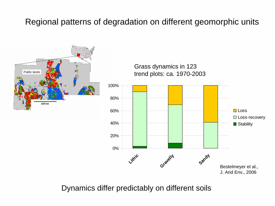
Dynamics differ predictably on different soils
Regional patterns of degradation on different geomorphic units
Grass dynamics in 123trend plots: ca. 1970-2003
100 km
Public lands
0%
20%
40%
60%
80%
100%
Lithic
Gravell
y
Sandy
LossLoss-recoveryStability
Bestelmeyer et al., J. Arid Env., 2006

Geomorphic position conditions vegetation dynamics:Erosion and deposition processes depend on landscape context
1969 2003
1962 2003
Active alluvial fan (gravelly soils)
Relict, dissected alluvial fan (gravelly soils)
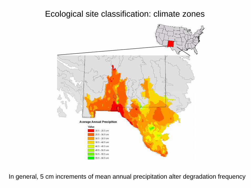
Ecological site classification: climate zones
In general, 5 cm increments of mean annual precipitation alter degradation frequency
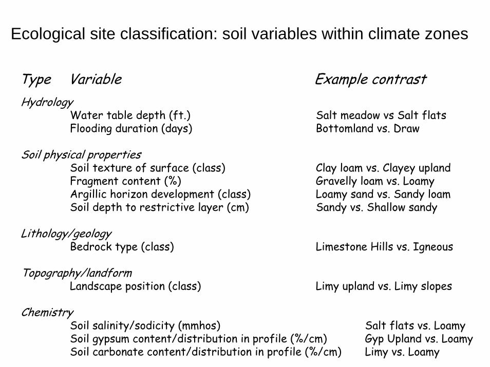
Ecological site classification: soil variables within climate zones
HydrologyWater table depth (ft.) Salt meadow vs Salt flatsFlooding duration (days) Bottomland vs. Draw
Soil physical propertiesSoil texture of surface (class) Clay loam vs. Clayey uplandFragment content (%) Gravelly loam vs. LoamyArgillic horizon development (class) Loamy sand vs. Sandy loamSoil depth to restrictive layer (cm) Sandy vs. Shallow sandy
Lithology/geologyBedrock type (class) Limestone Hills vs. Igneous
Topography/landformLandscape position (class) Limy upland vs. Limy slopes
ChemistrySoil salinity/sodicity (mmhos) Salt flats vs. LoamySoil gypsum content/distribution in profile (%/cm) Gyp Upland vs. LoamySoil carbonate content/distribution in profile (%/cm) Limy vs. Loamy
Type Variable Example contrast

Region-scale Ecological Site heterogeneity in the NM Chihuahuan Desert
Prediction of degradation and restoration requires location-specific data

Gravelly, shallow carbonatic relict fan(water limited, prone to shrub dominance)
Calcareous loamy(susceptible to water erosion)
Limestone hills (resistant grassland)
Gravelly active fan(shifting mosaic of grass and shrubs)
Clay bottom(receives water,highly resistant grassland)
Ecological sites comprise a functional landscape mosaic
Mosaic organization repeats across physiographic regions

Three kinds of vegetation/soil dynamics
“Resilient variation within states”
A. Reversible changes in plant abundance with changes in rainfall or disturbance pattern (grazing, fire) ~ patch dynamics
“Transition between states”
B. Changes in plant abundance that cannot be reversed until competitors or fire-adapted species are removed
C. Changes in plant abundance that cannot be reversed until erosion is stabilized and soil fertility, soil physical properties, or previous hydrology is restored.

Resilience = cover oscillation, loss and recovery
Basin floorClayey ecological site
Recovery possible evenat very low grass cover values
System resistant to soildegradation
System resistant to invasion
Locally-driven dynamics
1971 1980 1990 2003
0
5
10
1520
25
30
3540
45
1971 1975 1979 1983 1987 1991 1995 1999 2003
Year
% c
anop
y co
ver Tobosa cover

1984 1997
1988 2003
Transition: sediment deposition and landscape context
Basin floor: Loamy site adjacent to degrading loamy sand site
25 cm of fine sand accumulation abrading and burying tobosaLandscape-driven dynamics

3 km
c
c
oo
Geographic position may override local properties
Grassland preserved
Grassland lost

The dynamic relationship between soil and vegetation is key to defining thresholds
Detecting thresholds: surface soil tells a story
• Recent grassland loss
• Crossed a biotic threshold, soils not yet degraded
• Recovery possible
Dark A Light AGravelly land units
• Grassland absent for decades
• Crossed a soil degradation threshold
• Recovery improbable

Threshold/transition
Succession/disturbance
Restoration/remediation
Key to arrows
A. Continuous grazing or drought, recovery with prescribed grazing (B).
T1a. Continued grazing causes black grama loss. Restoration with plantings and 2 consecutive summers of above-average rainfall (T1b).
T2a. Continuous grazing, winter rain, plus lack of fire leads to mesquite proliferation and black grama extinction. Restoration with shrub control, plantings, summer rain, and fire management (T2b).
T3. Mesquite spread with high winter rain
T4a. Inappropriate stocking during drought with soil disturbance leads to high soil erosion rates in shrubinterspaces. Restoration of some grass cover with bulldozing, seeding and summer rain (T4b.)
Historic black gramagrassland
Mixed, patchygrassland
A
B
T4a
Snakeweed-Mesquiteshrubland
Threeawn-dropseedgrassland
T3
T4b
T2bT2a T1a T1b
Mesquite coppiceshrubland
Synthesize and communicate mechanisms in state-and-transition models
Sandy,200-250 mm MAP
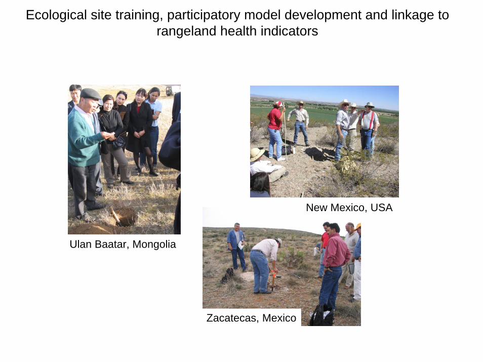
Ecological site training, participatory model development and linkage to rangeland health indicators
Ulan Baatar, Mongolia
New Mexico, USA
Zacatecas, Mexico
Recommended