8/17/2019 Nepalese Journal on Geo-informatics Number 14
http://slidepdf.com/reader/full/nepalese-journal-on-geo-informatics-number-14 1/65
NNNEEEPPPAAALLLEEESSSEEE JJJOOOUUURRRNNNAAALLL OOONNN
GGGEEEOOOIIINNNFFFOOORRRMMMAAATTTIIICCCSSS Number: 14 Jeth 2072 (May/June, 2015)
Annual Publication of Survey Department, Government of Nepal
8/17/2019 Nepalese Journal on Geo-informatics Number 14
http://slidepdf.com/reader/full/nepalese-journal-on-geo-informatics-number-14 2/65
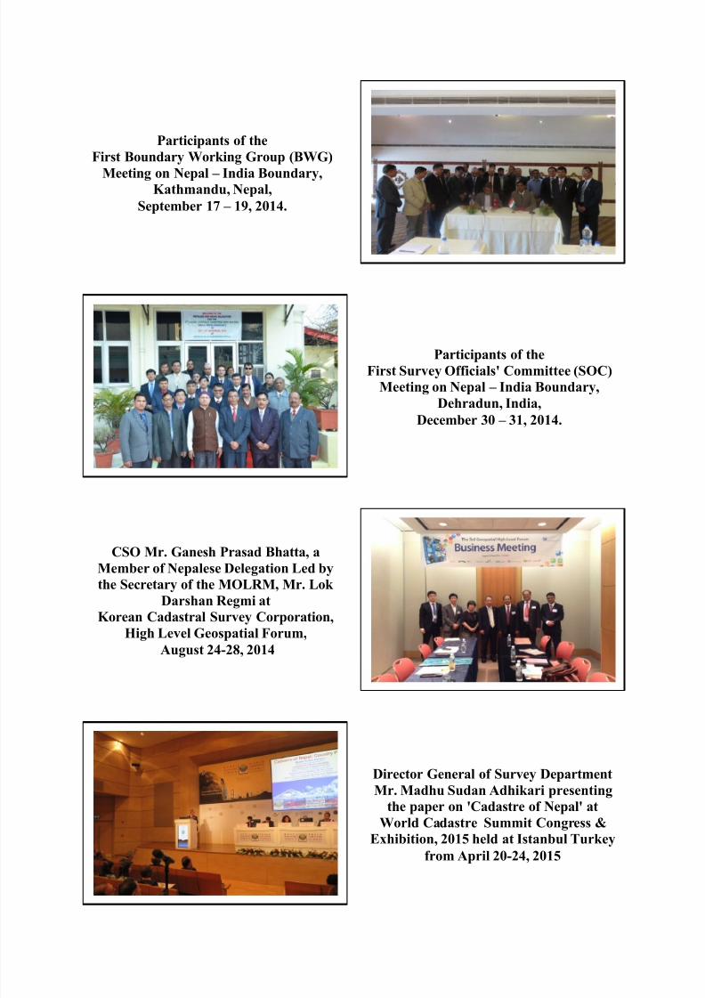
Participants of the
First Survey Officials' Committee (SOC)
Meeting on Nepal – India Boundary,
Dehradun, India,
December 30 – 31, 2014.
Participants of the
First Boundary Working Group (BWG)
Meeting on Nepal – India Boundary,Kathmandu, Nepal,
September 17 – 19, 2014.
CSO Mr. Ganesh Prasad Bhatta, a
Member of Nepalese Delegation Led by
the Secretary of the MOLRM, Mr. Lok
Darshan Regmi at
Korean Cadastral Survey Corporation,
High Level Geospatial Forum,
August 24-28, 2014
Director General of Survey Department
Mr. Madhu Sudan Adhikari presenting
the paper on 'Cadastre of Nepal' at
World Cadastre Summit Congress &
Exhibition, 2015 held at Istanbul Turkey
from April 20-24, 2015
8/17/2019 Nepalese Journal on Geo-informatics Number 14
http://slidepdf.com/reader/full/nepalese-journal-on-geo-informatics-number-14 3/65
Nepalese Journal on
Geoinformatics
Number : 14
Jeth 2072 BS
May / June 2015 AD
Annual publication of Survey Department, Government of Nepal
The content and the ideas of the articles are solely of authors.

8/17/2019 Nepalese Journal on Geo-informatics Number 14
http://slidepdf.com/reader/full/nepalese-journal-on-geo-informatics-number-14 4/65
Published by:
Government of Nepal
Ministry of Land Reform and Management
Survey DepartmentMin Bhawan, Kathmandu
Nepal
No. of copies : 500
© Copyright reserved by Survey Department
8/17/2019 Nepalese Journal on Geo-informatics Number 14
http://slidepdf.com/reader/full/nepalese-journal-on-geo-informatics-number-14 5/65
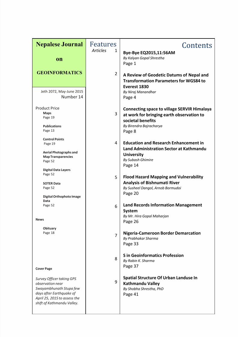
Jeth 2072, May-June 2015
Number 14
Product PriceMaps
Page 19
Publications
Page 13
Control Points
Page 19
Aerial Photographs and
Map Transparencies
Page 52
Digital Data Layers
Page 52
SOTER Data
Page 52
Digital Orthophoto Image
Data
Page 52
News
Obituary
Page 18
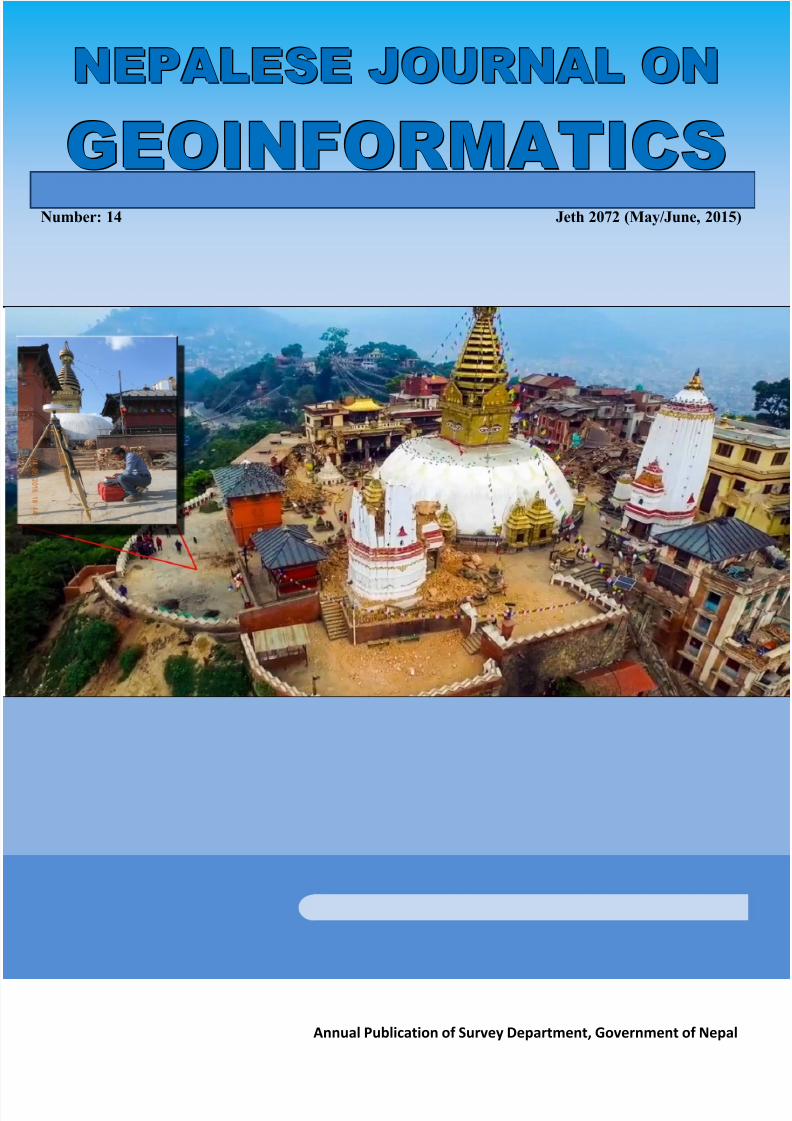
Cover Page
Survey Officer taking GPS
observation near
Swayambhunath Stupa few
days after Earthquake of April 25, 2015 to assess the
shift of Kathmandu Valley.
Features Articles 1
2
3
4
5
6
7
8
9
ContentsBye-Bye EQ2015,11:56AM
By Kalyan Gopal ShresthaPage 1
A Review of Geodetic Datums of Nepal and
Transformation Parameters for WGS84 to
Everest 1830By Niraj Manandhar
Page 4
Connecting space to village SERVIR Himalaya
at work for bringing earth observation to
societal benefitsBy Birendra Bajracharya
Page 8
Education and Research Enhancement in
Land Administration Sector at Kathmandu
University By Subash Ghimire
Page 14
Flood Hazard Mapping and VulnerabilityAnalysis of Bishnumati River By Susheel Dangol, Arnob Bormudoi
Page 20
Land Records Information Management
SystemBy Mr. Hira Gopal Maharjan
Page 26
Nigeria-Cameroon Border DemarcationBy Prabhakar Sharma
Page 33
S in Geoinformatics ProfessionBy Rabin K. Sharma
Page 37
Spatial Structure Of Urban Landuse In
Kathmandu ValleyBy Shobha Shrestha, PhD
Page 41
Nepalese Journal
on
GEOINFORMATICS
8/17/2019 Nepalese Journal on Geo-informatics Number 14
http://slidepdf.com/reader/full/nepalese-journal-on-geo-informatics-number-14 6/65
Professional
Organization
Pages
Regular
Columns
Information
ContentsNepal Remote Sensing and
Photogrammetric Society Page 50
Nepal Surveyor's Association (NESA)
Page 51
Editorial
Page i
Forewords
Page ii
Instruction and Guidelines for Authors
Regarding Manuscript Preparation
Page 32
Call for Papers
Page 13
Participation in International Events
Page 13
Calender of International Events
Page 25
Articles in Previous Issues
Page 46
8/17/2019 Nepalese Journal on Geo-informatics Number 14
http://slidepdf.com/reader/full/nepalese-journal-on-geo-informatics-number-14 7/65
Advisory Council
Editorial Board
Madhu Sudan Adhikari
Chairperson
Kalyan Gopal Shrestha
Member
Ganesh Prasad Bhatta
Member
Mohan Chand Thakuri
Member
Niraj Manandhar
Member
Sushil N. Rajbhandari
Member
Anil Marasini
Member
Ram Kumar Sapkota
Member
Suresh Man Shrestha
Editor-in-Chief
8/17/2019 Nepalese Journal on Geo-informatics Number 14
http://slidepdf.com/reader/full/nepalese-journal-on-geo-informatics-number-14 8/65
Editorial
After accomplishment of certain academic level, normally we join some professionalorganization and do some project works related to our profession. After some time we acquiresome skill in performing specific type(s) of work(s). With these academic knowledge and
practical skill in mind we may have/develop our future vision to further our profession. We allknow one man does not make a team, and without a team work no organization can achieve itsgoals in an efficient way. It is not necessary that a group of people makes a team. Each memberof a team should have certain level of knowledge and skill which can be shared to enhance theteam performance. Among many others, a periodic journal is an effective and efficient means ofknowledge sharing.
Realizing the value of knowledge sharing, Survey Department has been publishing its journal"Nepalese Journal on Geoinformatics" for last thirteen years. In last thirteen issues more than100 articles in a variety of themes related to geoinformation have been published. I would like toexpress sincere thanks to all those incredible authors for their contributions and members ofAdvisory Councils and Editorial Boards of all those issues of the journal for their persistentefforts to publish the journal.
At this point, I am very much thankful to the Survey Department for entrusting me with theresponsibility of the Editor-in-Chief for the fourteenth issue of the journal. Following the adviceand suggestions of Advisory Council, we, the members of Editorial Board have been able to
bring forth the fourteenth issue of the journal.
I believe that, we all can benefit from the development of the thinking and sharing knowledge inthe field of geoinformation. We have made a good start with a strong tradition of writing and
publishing case studies in our journals. We need to continue to improve upon our ability toreflect on what we are doing as we are doing it – this is essential for practicing professionals.
There are many challenges in the field of research works. Lack of appropriate data, hardwareand software for research, consistant methodology et cetera are not creating conduciveenvironment for research. Most of the times we do not seriously think about what should we beobserving, measuring and asking questions about? What constitutes improvement? When is animprovement in one part of a complex system meaningful in the dynamics of the whole system?Yet these conceptual approaches present significant difficulties in designing research – identifying suitable questions, identifying and capturing the complexity of the interactions
between large numbers of variables, etc. Despite these constraints, embracing the question of
research has much to offer us. To better understand some of the phenomena we observe in practice, we need to improve our language and try to present the results in a way which is simpleto understand for the readers. For these benefits we need to engage in a dialogue within our
professional field. This Journal is a part of that process.
On behalf of all the members of the Editorial Board, I would like to express sincere thanks to allcontributing authors, members of Advisory Council and all others who have contributed for the
publication of this issue of the journal. Last but not the least, I feel privileged and honored towork as the Editor-in-Chief.
Suresh Man Shrestha,
Editor-in-Chief
2072 Jeth,
Kathmandu
i
8/17/2019 Nepalese Journal on Geo-informatics Number 14
http://slidepdf.com/reader/full/nepalese-journal-on-geo-informatics-number-14 9/65
Forewords
I am very much delighted to write a few words of introduction to the fourteenth issue of'Nepalese Journal on Geoinformatics'. The journal has been published at a very important time –
there is clearly an upsurge of interest in ICT based solutions in our professional field. And this journal has been one of the platforms for sharing professional knowledge among us.
Being a National Mapping Authority, Survey Department has generated a huge amount ofnationwide geographical information related to our land, one of the basic sources of ourlivelihood. With the developments of technologies in the field of geoinformation and to caterever growing demands of the geoinformation users, Survey Department must update itsgeoinformation in its possession. And dare to change itself to be in par with the moderntechnology.
Survey Department is going to adopt a new set of transformation parameters to interchange its
geoinformation in traditional ellipsoid, Everest-1830 with modern WGS84 system. This is goingto be a great achievement for the users of our geoinformation and GPS based technology. ChiefSurvey Officer Mr. N. Manandhar has put a lot of effort in this regard and his article will be ofgreat value for our department.
There are a lot of issues to be understood about how we use geoinformation. Implicit in ourwork are many aspects of the scientific method as it is actually practiced in the laboratory.Increasing our scientific literacy level can improve our ability to think about our work. Articles
by Mr. Sharma Rabin K., Mr. Bajracharya Birendra, Ms. Shrestha Shobha, PhD, Mr. GhimireSubash, Mr. Dangol Susheel, Mr. Maharjan Hira G. are very good examples in this regard.
Starting this fiscal year, Nepal and India have resumed their boundary field works. Experienceshared by Mr. Sharma Prabhakar on boundary survey works is surely going to be of great helpfor the surveyors involved in Nepal-India border field works.
The Earthquake of Baishakh 12, 2072 (April 25, 2015) shook almost all central part of Nepal,killed thousands of people, made thousands of people homeless, damaged/destroyed physicalinfrastructures including houses and put lives of nepali people in a very difficult situation at this
point of our history. Destruction of historic monuments, specially in Kathmandu Valley, has been a very bitter truth. But, as many others, the staff of Survey Department stood determined toassist the rescue works of initiated by our government. We published geoinformation useful forrescue works. This information can be downloaded from www.dos.gov.np and www.ngiip.gov.np forfree. Similarly our staff are busy in making maps, performing research regarding the possibleshift of earthquake hit area and many are deputed to earthquake hit districts to assist rescueworks. I am very proud to be the Director General of such devoted staff with professionalobsession.
Very special thanks go to the members of the Editorial Board who brought out this issue of journal within a very short time period. I highly appreciate the effort of all the authors of thearticles for sharing their knowledge. Finally, to conclude, I wholeheartedly invite and encouragenew professionals to contribute to the noble cause of this journal in future.
Mr. Madhusudan Adhikari,Director General,Survey Department,
Jeth, 2072 ii

8/17/2019 Nepalese Journal on Geo-informatics Number 14
http://slidepdf.com/reader/full/nepalese-journal-on-geo-informatics-number-14 10/65
8/17/2019 Nepalese Journal on Geo-informatics Number 14
http://slidepdf.com/reader/full/nepalese-journal-on-geo-informatics-number-14 11/65
Bye-Bye EQ2015,11:56am
Nepalese Journal on Geoinformatics, Survey Department, Nepal
1
BYE-BYE EQ2015,11:56AM
Kalyan Gopal Shrestha
DDG, Topographical Survey Branch,
Survey Department
A huge earthquake with the magnitude of 7.6 MLwhich occurred at 11:56 NST on 25th April 2015shook Nepal killing more than 8,800 people, injuringmore than 22,000 people, leaving hundreds ofthousands of people homeless and leveling housesand centuries old architectural structures. The quake'sepicenter was at Barpak village in Gorkha district, 80kilometers northwest of Kathmandu, and it had adepth of only 15 kilometers, which is consideredshallow in geological terms. The shallower the quakethe more destructive power it carries. It also triggered
an avalanche on Mt. Everest which is believed tohave killed at least 10 climbers. It was the worstnatural disaster to strike Nepal since the 1934 Nepal -Bihar Earthquake.
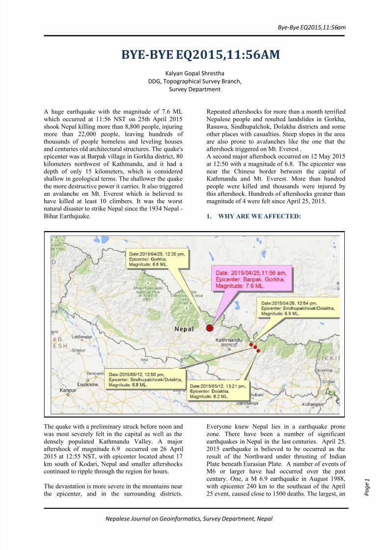
The quake with a preliminary struck before noon andwas most severely felt in the capital as well as thedensely populated Kathmandu Valley. A majoraftershock of magnitude 6.9 occurred on 26 April2015 at 12:55 NST, with epicenter located about 17km south of Kodari, Nepal and smaller aftershockscontinued to ripple through the region for hours.
The devastation is more severe in the mountains nearthe epicenter, and in the surrounding districts.
Repeated aftershocks for more than a month terrified Nepalese people and resulted landslides in Gorkha,Rasuwa, Sindhupalchok, Dolakha districts and someother places with casualties. Steep slopes in the areaare also prone to avalanches like the one that theaftershock triggered on Mt. Everest .A second major aftershock occurred on 12 May 2015at 12:50 with a magnitude of 6.8. The epicenter wasnear the Chinese border between the capital ofKathmandu and Mt. Everest. More than hundred
people were killed and thousands were injured by
this aftershock. Hundreds of aftershocks greater thanmagnitude of 4 were felt since April 25, 2015.
1. WHY ARE WE AFFECTED:
Everyone knew Nepal lies in a earthquake pronezone. There have been a number of significantearthquakes in Nepal in the last centuries. April 25,2015 earthquake is believed to be occurred as theresult of the Northward under thrusting of IndianPlate beneath Eurasian Plate. A number of events ofM6 or larger have had occurred over the past
century. One, a M 6.9 earthquake in August 1988,with epicenter 240 km to the southeast of the April25 event, caused close to 1500 deaths. The largest, an
8/17/2019 Nepalese Journal on Geo-informatics Number 14
http://slidepdf.com/reader/full/nepalese-journal-on-geo-informatics-number-14 12/65
Bye-Bye EQ2015,11:56am
Nepalese Journal on Geoinformatics, Survey Department, Nepal
M 8.3 event known as the 1934 Nepal - Biharearthquake, struck at 2.30PM on 15 January 1934 ina similar location to the 1988 event. It severelydamaged Kathmandu valley, and is thought to havecaused around 10,600 deaths.
Millions of years ago, the Indian continent collidedinto Southern Tibet. The Indian continent is drivenunder Tibet, pushing lightweight sediments upwardsand thus the formation of the Himalayas. Nepal isresting on these colliding tectonic plates:Eurasian(Tibetan) plate and Indian plate, which arestill moving towards each other by 2 meters percentury. This movement creates pressure within theEarth, which builds up and can only be releasedthrough earthquakes. Thus earthquakes happen veryoften in Nepal. Based on the seismic record since1255, earthquakes of magnitude greater than 8occurred on average once every 80 years.
The latest earthquake was not “unexpected”,everybody knew it was coming sooner or later,experts had warned of the danger to the people ofKathmandu for decades. Since Kathmandu and thesurrounding valley sit on an ancient dried-up lake
bed with very, very soft soil, and the soft soilamplified seismic motion, death toll in Nepal on that
black Saturday was practically inevitable given thetectonics, the local geology that made the shakingworse and the lax discipline in the construction of
buildings that could not withstand the shaking. Theearthquake occurred to the northwest of Kathmandu
at a relatively shallow depth of about 15 kms, whichcaused greater shaking at the surface lasted for about2 minutes, but at magnitude 7.6, it released lessenergy than the 1934 quake.
Seismologists have done a preliminary analysis ofApril 25, 2015 earthquake. Subsequent rupturesalong the fault set off the number of aftershocks.This means a lot of the tectonic tension beneathCentral Nepal has now been released possibly
postponing a mega-earthquake for now. However,according to the Geologists, we are not in a positionto ignore the possibility for an even bigger one in
western Nepal. And a M8.5 earthquake in western Nepal will shake Kathmandu up even more than theM7.6 on April 25, 2015.
Earthquakes have tectonic origins and we call them‘natural disasters’, The trouble in Nepal is that there
is not enough research on risks. Kathmandu is proneto severe shaking even during minor quakes becausethe city is built on clay and sediment of a previouslake, and is also prone to liquefaction.
2. CONTRIBUTION OF SURVEY
DEPARTMENT:
According to scientists, the devastating earthquakeand aftershocks as large as magnitude 6 that struck
on April 25, 2015 and on following days could havecaused permanent changes of the Earth's surface. As
part of the earthquake process, Earth's surface couldhave deformed as earthquake faults accumulate strainand slip or slowly creep over time. SurveyDepartment(SD) use GPS to monitor this movement
by measuring the precise position (within 5mm orless) of stations near active faults relative to eachother. We compare the results with those of the
previous observation results derived by occupyingthe same stations to determine the movement'smagnitude and directions. By determining how thestations have moved we calculate grounddeformation.
In the aftermath of earthquakes of April 25, 2015,Survey Department in it's capacity as NationalMapping Agency carried out investigations based onGlobal Positioning System(GPS) field survey
preliminarily in and around the capital city ofKathmandu in order to investigate the movement andchange of elevation caused by the earthquake. Fivestations surrounding Kathmandu valley: Nagarkot ofBhaktapur, Lakhe danda of Bungamati, Swayambhuof Kathmandu, Kumari of Nuwakot, Phulchoki hillof Lalitpur were selected as sample points. Theanalysis on surveyed data reveals that earthquakeshifted Nagarkot by 1.82 m southwest, Phulchoki by0.92m southwest. Likewise Bungmati, Swayambhuand Kumari shifted by 0.99 m south, 1.64 msouthwest and 1.71 m southwest respectively.Regarding the Ellipsoidal elevation Nagarkot,
Phulchoki, Bungmati, Swayambhu and Kumarifound to be elevated by 1.158 m, 0.63 m, 0.77 m,0.98 m and 1.093 m respectively.
The rigorous calculations were done linking with theobservation data in 13 Continuously OperatingReference Stations (CORS) distributed in Hongkong,Lhasa, Bangalore, Hyderabad, Kazakastan, Oman,Mongolia. Thus calculated Post - earthquakecoordinate values were compared with the Pre -earthquake corresponding coordinates compliantwith International Terrestrial Reference Frame 2008adopted by International GNSS Service (IGS). The
primary result of the research was unveiled to the public in a Press meet.
The hundreds of aftershocks continued even after thisunveiling of the result. The positions of NationalGeodetic Network have been suffered from the greatearthquake. Therefore, a complete revival of the
Network is a must. Survey Department must developan immediate update to the reference positions ofcontrol points to publish a new set of recalculatedcoordinates. Since Nepal lies in the boundary ofIndian and Tibetan plates, the accumulated strainsand crustal deformations caused by plate subduction
will more or less continue in future too. Thus, SDshould introduce dynamic/semi-dynamic correctionmethod to solve major problem with revision of
8/17/2019 Nepalese Journal on Geo-informatics Number 14
http://slidepdf.com/reader/full/nepalese-journal-on-geo-informatics-number-14 13/65
Bye-Bye EQ2015,11:56am
Nepalese Journal on Geoinformatics, Survey Department, Nepal
survey results, that is, how to manage relation between static geodetic datum and actually moving positions of reference points and how to reduce thetotal cost for revision in future.
SD has made the provision of allowing free
download of Topographic data of the earthquakeaffected area which includes 17 districts and can bedownloaded from http://www.ngiip.gov.np. The dataon the web includes Transportation, Hydrography,VDC boundary and Place name. The data can beused freely for earthquake disaster analysis purposeonly by the organization who are working fordisaster rescue and mapping activities of the disasteroccurred due to the recent earthquake of April 25,2015.
The department has also published Post Disaster webmap to support the relief efforts. Most of these maps
are focused on the 11 most affected districts.
Apart from these, the department has also publishedan interactive web map at http://www.ngiip.gov.np
/EARTHQUAKE2072/Earthquake.html where one can seethe number of deaths, injured etc and the departmentis updating this interactive web map as far as
possible.
Within less than a month, we have felt more than 250incidents of earthquake of magnitude 4+. It is morethan enough! So enough is enough. On behalf of allnepalese let us say BYE – BYE Earthquake 2015.
See you never again!
References
DoGM, Government of Nepal (2014) General
Geology
Howard, B.C. (2015) Nepal Earthquake Strikes one
of the earth's most quake-prone areas, NationalGeographic.
Nepal Earthquake rajuba.info
NIDM, Ministry of Home Affairs, India Geological Disaster
Survey Department (2015) Press Release USGS, M7.3 - 18 Km. SE of Kodari, Nepal
8/17/2019 Nepalese Journal on Geo-informatics Number 14
http://slidepdf.com/reader/full/nepalese-journal-on-geo-informatics-number-14 14/65
A Review of Geodetic Datums of Nepal and Transformation Parameters for WGS84 to Geodetic Datum of Nepal
Nepalese Journal on Geoinformatics, Survey Department, Nepal
A REVIEW OF GEODETIC DATUMS OF NEPAL AND
TRANSFORMATION PARAMETERS FOR WGS84
TO GEODETIC DATUM OF NEPAL
Niraj Manandhar
Keywords: WGS84, Everest 1830, ENTMP, WNTMP, Transformation Parameter, Datum, GPS.
Abstract: In Nepal there exist different coordinate systems based on different geodetic datum. The existence of
these datum and coordinate systems are poorly known. In this literature the geodetic datum that is in existence
in one way or other are illustrated and discussed. The next common problem encountered by users is the
availability of authentic precise transformation parameter between National geodetic datum and World
Geodetic Datum 1984 (WGS84) ; global datum used by global positioning system (GPS). There can exist aconsiderable difference in the position between local and the global system and the difference could be of several
hundred meters.
Based on the availability of data three sets of transformation parameters has been determined. The tests have
been carried out to evaluate the accuracy of the transformation parameter in this region. The transformation
parameter is recommended to transform the topographical data base of scale 1: 3500 and smaller. The
accuracy of the transformation parameters are specified and can be used accordingly. This study will ultimately
provide standardization and ease in transforming the coordinates from global datum (WGS84) to national
geodetic datum of Nepal and vice versa.
1.
INTRODUCTION:
The national and regional surveying and mapping
works are all based on one single framework of
geodetic control which is considered as a primary
network of the country. The importance of the
geodetic frame work for the country is beyond
justification and is applied in almost all development
works of the country such as defense, satellite
lunching, missiles projecting etc, construction of
major infrastructures of the country (dams, roads,
sewerage system, irrigation, hydropower stations etc).
The concept of the position defined by co-ordinate
system is the most essential part in the process of
map-making and to the performance of the spatial
search and analysis of geographic information. In
order to plot the geographical feature on the map it is
necessary to define the position of points on the
features with respect to a common frame of reference
or the co-ordinate system in other words.
In the other hand all the observations and
measurements for accurate mapping are carried out onthe physical surface of the earth where as
computations and representation of the earth surface
into paper in the form of map requires mathematicalfigure of the earth. In order words there has to have
some relationship between the mathematical earth
(ellipsoid) and the physical earth (geoid). In the
geodetic terms we need to define best fitting ellipsoid
and geoid. The best fitting ellipsoid is that particular
ellipsoid which best fits the spread of the earth surface
of a particular country. Therefore there are different
ellipsoids of different country and hence different
countries have different origin and different datum
defined by certain parameters.
2. GEODETIC DATUM:
Precise positioning of points on the surface of the
earth is one of the fundamental goal of geodesy . In
order to define such point a starting point with respect
to the reference system and a reference ellipsoid is
necessary. The primary or the first order network is
defined by means of well defined three-dimensional
reference system of co-ordinates related to the earth
fixed reference system. Such a reference system is
defined by the dimension of the reference ellipsoid in
terms of five parameters such as semi-major axis 'a'and flattening 'f' and its position represented by
regional X, Y, Z or , , h system specifying the
8/17/2019 Nepalese Journal on Geo-informatics Number 14
http://slidepdf.com/reader/full/nepalese-journal-on-geo-informatics-number-14 15/65
A Review of Geodetic Datums of Nepal and Transformation Parameters for WGS84 to Geodetic Datum of Nepal
Nepalese Journal on Geoinformatics, Survey Department, Nepal
orientation with respect to the global system, hence
with respect to earth or geoid.
Usually the centre of the ellipsoid does not coincide
with the earth's centre of mass but that axis is made
parallel to the earth's axis of rotation with a preassumption that global Xg, Yg, Zg rectangular co-
ordinate system, has the origin which lies on the
earth's centre of mass and a Z axis coinciding with the
mean rotating axis of the earth, X - axis passing
through the mean of the Greenwich Meridian. The Y -
axis as defined by the plane which is perpendicular to
X and Z - axis (Torge, 1991, pl 38).
3. NATIONAL GEODETIC DATUM (NEPAL
DATUM):
In Nepal different geodetic datums have been used indifferent times for mapping purpose. The table 1
below shows the difference between them.
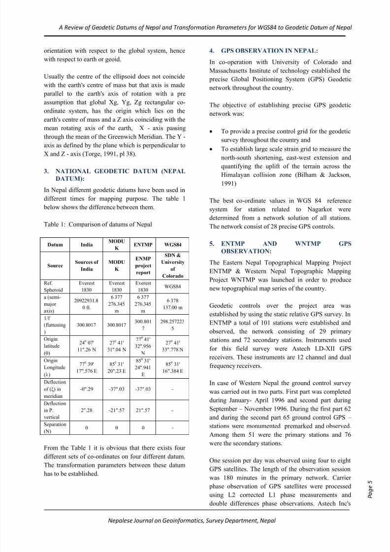
Table 1: Comparison of datums of Nepal
Datum IndiaMODU
KENTMP WGS84
SourceSources of
India
MODU
K
ENMP
project
report
SDN &
University
of
Colorado
Ref.
Spheroid
Everest
1830
Everest
1830
Everest
1830WGS84
a (semi-
major
axis)
20922931.8
0 ft.
6 377
276.345
m
6 377
276.345
m
6 378
137.00 m
1/f
(flattening
)
300.8017 300.8017300.801
7
298.257223
5
Origin
latitude
()
240 07'
11".26 N
270 41'
31".04 N
270 41'
32".956
N
270 41'
33".778 N
Origin
Longitude
()
770 39'
17".576 E
850 31'
20".23 E
850 31'
24".941
E
850 31'
16".384 E
Deflection
of () in
meridian
-0".29 -37".03 -37".03 -
Deflection
in P.
vertical
2".28 -21".57 21".57 -
Separation
(N)0 0 0 -
From the Table 1 it is obvious that there exists four
different sets of co-ordinates on four different datum.
The transformation parameters between these datum
has to be established.
4. GPS OBSERVATION IN NEPAL:
In co-operation with University of Colorado and
Massachusetts Institute of technology established the
precise Global Positioning System (GPS) Geodetic
network throughout the country.
The objective of establishing precise GPS geodetic
network was:
To provide a precise control grid for the geodetic
survey throughout the country and
To establish large scale strain grid to measure the
north-south shortening, east-west extension and
quantifying the uplift of the terrain across the
Himalayan collision zone (Bilham & Jackson,
1991)
The best co-ordinate values in WGS 84 reference
system for station related to Nagarkot were
determined from a network solution of all stations.
The network consist of 28 precise GPS controls.
5. ENTMP AND WNTMP GPS
OBSERVATION:
The Eastern Nepal Topographical Mapping Project
ENTMP & Western Nepal Topographic Mapping
Project WNTMP was launched in order to produce
new topographical map series of the country.
Geodetic controls over the project area was
established by using the static relative GPS survey. In
ENTMP a total of 101 stations were established and
observed, the network consisting of 29 primary
stations and 72 secondary stations. Instruments used
for this field survey were Astech LD-XII GPS
receivers. These instruments are 12 channel and dual
frequency receivers.
In case of Western Nepal the ground control survey
was carried out in two parts. First part was completed
during January- April 1996 and second part during
September – November 1996. During the first part 62
and during the second part 65 ground control GPS –
stations were monumented premarked and observed.
Among them 51 were the primary stations and 76
were the secondary stations.
One session per day was observed using four to eight
GPS satellites. The length of the observation session
was 180 minutes in the primary network. Carrier
phase observation of GPS satellites were processed
using L2 corrected L1 phase measurements and
double differences phase observations. Astech Inc's
8/17/2019 Nepalese Journal on Geo-informatics Number 14
http://slidepdf.com/reader/full/nepalese-journal-on-geo-informatics-number-14 16/65
A Review of Geodetic Datums of Nepal and Transformation Parameters for WGS84 to Geodetic Datum of Nepal
Nepalese Journal on Geoinformatics, Survey Department, Nepal
Geodetic post-processing software (GPPS), version
4.4.01 was used for the data processing. The
adjustment of the network was done by using in
FILNET (version 3.0.00) adjustment program.
One sigma accuracy of the baselines in the Network is better than 1-5 ppm.
6. DATUM TRANSFORMATION
PARAMETERS:
The present study is focused on the estimation of
transformation parameters between Everest and
WGS-84 in order to transform the digital data of the
topographical maps or the ground control points
(GCP).
The topographical mapping project was launched inorder to update the topographical maps of the country.
The topographical maps of Nepal are prepared and
published in two parts. One of the Eastern Nepal and
other of the Western Nepal. In both cases geodetic
control was done by GPS/GNSS survey. As the main
aim of the project was to provide control for the
topographical mapping, it was felt important to
transform GPS control from WGS84 to local datum. It
was found that the distribution of common points has
a good network geometry for transformation. Hence
for the derivation of the seven parameter
transformation controls considered from ENTMP and
WNTMP was given considerable weight.
Similarly, in the process of the determination of the
transformation parameter of WNTMP, 22 collocated
points (the common points between the reference
frame i.e. WGS-84 and Everest 1830) first order
points based on Nepal datum were used.
In the computation of transformation parameter 3-
dimentional coordinates based on WGS-84 were taken
as the controls established by WNTMP and ENTMP.This network consists of all together 80 primary
stations and 148 secondary stations. A total of 33
primary GPS points were common stations in first
order geodetic network of Nepal. These 33 stations
are used for the derivation of the transformation
parameter. 33 stations of first order network of Nepal
based on Nepal datum were obtained from appendix
(1) report of Ministry of Defense United Kingdom
(MODUK). The Bursa-Wolf method was used to
estimate the transformation parameter.
The values of the transformation (WGS-84 to
Everest1830) parameters are as follows:
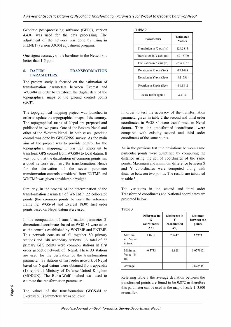
Table 2
ParametersEstimated
Values
Translation in X axis(m) 124.3813
Translation in Y axis (m) -521.6700
Translation in Z axis (m) -764.5137
Rotation in X axis (Sec) -17.1488
Rotation in Y axis (Sec) 8.11536
Rotation in Z axis (Sec) -11.1842
Scale factor (ppm) 2.1105
In order to test the accuracy of the transformation
parameter given in table 2 the second and third order
coordinates in WGS-84 were transformed to Nepal
datum. Then the transformed coordinates were
compared with existing second and third order
coordinates of the same points.
As in the previous test, the deviations between same
particular points were quantified by computing the
distance using the set of coordinates of the same
points. Maximum and minimum difference between X
and Y co-ordinates were computed along with
distance between two points. The results are tabulated
in table 3.
The variations in the second and third order
Transformed coordinates and National coordinates are
presented below:
Table 3
Difference in
X
coordinates(
ΔX)
Difference in
Y
coordinates(
ΔY)
Distance
between the
points
Maximu
m Value
in (m)
1.0717 2.7447 2.7737
Minimun
Value in
(m)
-0.5733 -1.828 0.077912
Average 0.872848
Referring table 3 the average deviation between the
transformed points are found to be 0.872 m therefore
this parameter can be used in the map of scale 1: 3500
or smaller.
8/17/2019 Nepalese Journal on Geo-informatics Number 14
http://slidepdf.com/reader/full/nepalese-journal-on-geo-informatics-number-14 17/65
A Review of Geodetic Datums of Nepal and Transformation Parameters for WGS84 to Geodetic Datum of Nepal
Nepalese Journal on Geoinformatics, Survey Department, Nepal
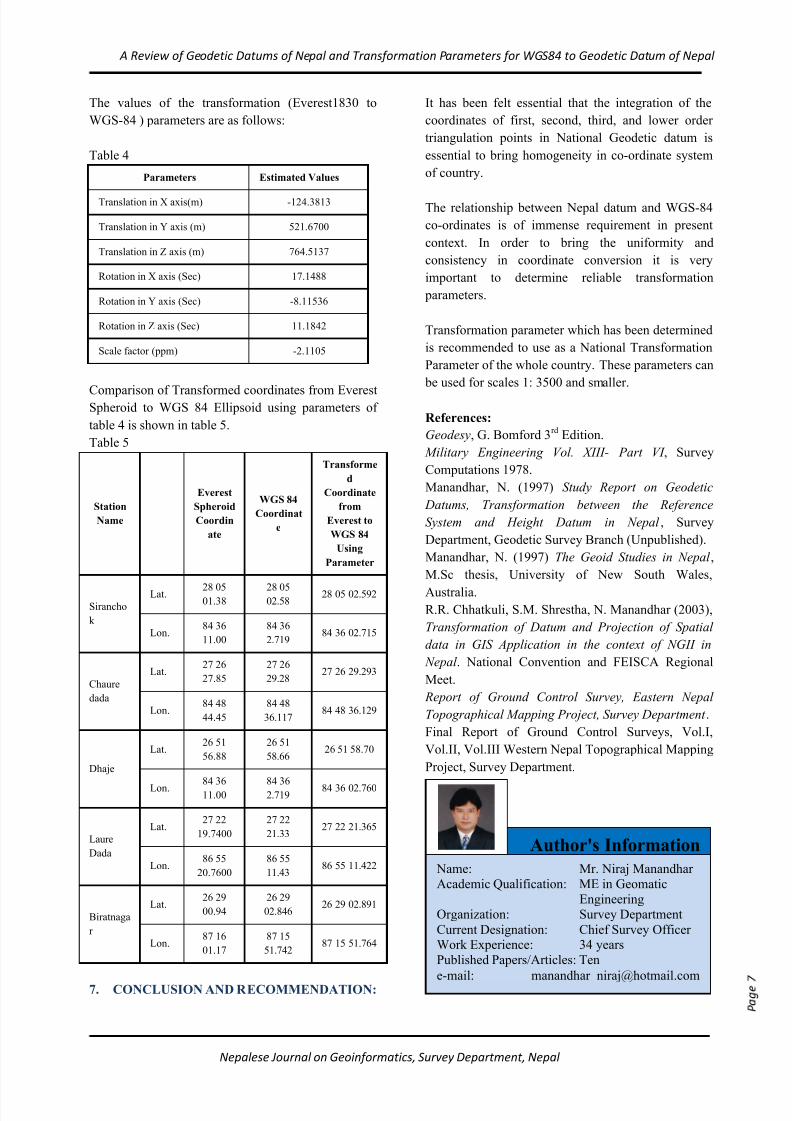
The values of the transformation (Everest1830 to
WGS-84 ) parameters are as follows:
Table 4
Parameters Estimated Values
Translation in X axis(m) -124.3813
Translation in Y axis (m) 521.6700
Translation in Z axis (m) 764.5137
Rotation in X axis (Sec) 17.1488
Rotation in Y axis (Sec) -8.11536
Rotation in Z axis (Sec) 11.1842
Scale factor (ppm) -2.1105
Comparison of Transformed coordinates from EverestSpheroid to WGS 84 Ellipsoid using parameters of
table 4 is shown in table 5.
Table 5
Station
Name
Everest
Spheroid
Coordin
ate
WGS 84
Coordinat
e
Transforme
d
Coordinate
from
Everest to
WGS 84
Using
Parameter
Sirancho
k
Lat. 28 0501.38
28 0502.58
28 05 02.592
Lon.84 36
11.00
84 36
2.71984 36 02.715
Chaure
dada
Lat.27 26
27.85
27 26
29.2827 26 29.293
Lon.84 48
44.45
84 48
36.11784 48 36.129
Dhaje
Lat.26 51
56.88
26 51
58.6626 51 58.70
Lon. 84 3611.00
84 362.719
84 36 02.760
Laure
Dada
Lat.27 22
19.7400
27 22
21.3327 22 21.365
Lon.86 55
20.7600
86 55
11.4386 55 11.422
Biratnaga
r
Lat.26 29
00.94
26 29
02.84626 29 02.891
Lon.87 16
01.17
87 15
51.74287 15 51.764
7.
CONCLUSION AND RECOMMENDATION:
It has been felt essential that the integration of the
coordinates of first, second, third, and lower order
triangulation points in National Geodetic datum is
essential to bring homogeneity in co-ordinate system
of country.
The relationship between Nepal datum and WGS-84
co-ordinates is of immense requirement in present
context. In order to bring the uniformity and
consistency in coordinate conversion it is very
important to determine reliable transformation
parameters.
Transformation parameter which has been determined
is recommended to use as a National Transformation
Parameter of the whole country. These parameters can
be used for scales 1: 3500 and smaller.
References:
Geodesy, G. Bomford 3rd
Edition.
Military Engineering Vol. XIII- Part VI , Survey
Computations 1978.
Manandhar, N. (1997) Study Report on Geodetic
Datums, Transformation between the Reference
System and Height Datum in Nepal , Survey
Department, Geodetic Survey Branch (Unpublished).
Manandhar, N. (1997) The Geoid Studies in Nepal ,
M.Sc thesis, University of New South Wales,
Australia.R.R. Chhatkuli, S.M. Shrestha, N. Manandhar (2003),
Transformation of Datum and Projection of Spatial
data in GIS Application in the context of NGII in
Nepal . National Convention and FEISCA Regional
Meet.
Report of Ground Control Survey, Eastern Nepal
Topographical Mapping Project, Survey Department .
Final Report of Ground Control Surveys, Vol.I,
Vol.II, Vol.III Western Nepal Topographical Mapping
Project, Survey Department.
Name: Mr. Niraj ManandharAcademic Qualification: ME in Geomatic
EngineeringOrganization: Survey DepartmentCurrent Designation: Chief Survey OfficerWork Experience: 34 yearsPublished Papers/Articles: Ten
e-mail: [email protected]
Author's Information
8/17/2019 Nepalese Journal on Geo-informatics Number 14
http://slidepdf.com/reader/full/nepalese-journal-on-geo-informatics-number-14 18/65
Connecting Space To Village: SERVIR Himalaya At Work For Bringing Earth Observation To Societal Benefits
Nepalese Journal on Geoinformatics, Survey Department, Nepal
CONNECTING SPACE TO VILLAGE: SERVIR
HIMALAYA AT WORK FOR BRINGING EARTH
OBSERVATION TO SOCIETAL BENEFITS
B. Bajracharya, MSR Murthy
Keywords: SERVIR, Earth observation, Gospatial Information, Satellite image
Abstract: Earth observation plays an important role in understanding earth as a system by providing repetitive and
consistent view throughout the globe for regular assessment and monitoring. There are a number of initiatives
working globally to facilitate and promote the earth observation applications. SERVIR is one such global initiative
evolved through partnership between USAID and NASA with an overarching goal to improve environmental
management and resilience to climate change. SERVIR-Himalaya is being implemented by ICIMOD to provideintegrated and innovative geospatial solutions for generation and dissemination of information and knowledge
resources on mountain environments in the Hindu Kush Himalaya region. The SERVIR applications are focused on
the broad thematic areas which are also subset of the societal benefit areas of Global Earth Observation (GEO),
namely - agriculture and food security, ecosystems and sustainable landscapes, and disaster risk management. Some
of its applications in Nepal include agriculture drought monitoring; land cover dynamics; biomass estimation at local
and national scales; climate change vulnerability to forest ecosystems; multi-scale disaster risk assessment; and forest
fire detection and monitoring. Access to these applications and data are facilitated through ICIMOD’s Mountain
Geoportal and Regional Database System. Regional and national training and workshops, on-the-job training,
internships and exchange programs and technical backstopping are key capacity building components to enhance the
capacity of national institutions in the regional member countries. These efforts are also seen as receiving feedback
on the science applications, identify additional needs, and increase synergy by exploring opportunities for
collaboration.
1. INTRODUCTION:
1.1. Earth Observation in the Global Context
Importance of earth observation to understand earth as
a system has been increasingly recognized by the
global scientific communities and professionals. Earth
observation plays a major role in the assessment of
our environment by providing repetitive and
consistent view throughout the globe. The increasing
concerns of climate change impacts in recent decades
have emphasized the importance of earth observation
applications in the areas such as climate modelling,
assessment of snow and glaciers, agriculture
monitoring and disaster risk reduction. A number of
initiatives have been working globally to facilitate and
promote the earth observation applications. The
Global Climate Observation System (GCOS) provides
for comprehensive observations for research and for
detecting and attributing climate change to support the
United Nations Framework Convention on Climate
Change (UNFCCC) through harmonized national
observation systems to avoid both gaps and
redundancies in Earth observation programs (Lewis et
al 2010). GCOS works towards ensuring free and
unrestricted availability of climate and related data for
informed decision making. The Committee on Earth
Observation Satellites (CEOS), is another principal
body for coordinating Earth observation among
national civil space programs. It also supports the
Group on Earth Observation (GEO), an operational
body established in 2005 to provide “a single,
comprehensive and sustained system for Earth
Observation.” GEO, with a permanent secretariat in
Geneva, is a voluntary partnership of governments
and international organizations that provides a
framework for coordinated strategies and investments
(GEO 2013). GEO is the body that coordinates and
sets up the architecture for the “system of systems”
(GEOSS) to ensure complete coverage and
compatibility of data. Nepal has been a member
nation of GEO since the beginning.
The release of the entire Landsat archive to all users at
no cost has been a major contribution to the
Geospatial community. Since the Landsat imageswere made free by the National Aeronautics and
Space Administration (NASA) and the United States

8/17/2019 Nepalese Journal on Geo-informatics Number 14
http://slidepdf.com/reader/full/nepalese-journal-on-geo-informatics-number-14 19/65
Connecting Space To Village: SERVIR Himalaya At Work For Bringing Earth Observation To Societal Benefits
Nepalese Journal on Geoinformatics, Survey Department, Nepal
Geological Survey (USGS) in December 2008, over
19 million scenes have been downloaded till August
2014 (USGS 2014). Another encouraging step was the
announcement by the White House on 23 September
2014 during the United Nations Heads of State
Climate Summit in New York regarding the releasethe high-resolution (30mx30m) images of Shuttle
Radar Topography Mission (SRTM) globally. The
availability of high resolution Digital Elevation Model
(DEM) will help in better analysis of the mountain
environments like Nepal.
The visualization using high resolution images,
geographic data including 3D terrain in Google Earth
has revolutionized the way people use Geographic
information. Browsing digital geographic information
over the web (geobrowsing) has led to development of
innovative applications to explore data
geographically, and visualise overlaid information
provided by diverse contributors. Integration of
geobrowsers such as Google Earth and Google Map
through application programming interfaces (APIs)
has popularized the use of map for serving all sorts of
information. Similarly, introduction of smartphones
with map based applications and GPS has brought
GIS into fingertips of common people. There is a
huge potential for mobile applications in view of 88%
mobile penetration in Nepal (NTA, 2015).
The more open policies on earth observation and
wider access and affordability of consumer products
enabling use of spatial information has brought in new
paradigm in GIS application development and use.
2. THE SERVIR INITIATIVE
2.1. SERVIR-Himalaya: connecting space to
village
SERVIR is a regional visualisation and monitoring
system that integrates earth observations such as
satellite imagery and forecast models together with insitu data and other knowledge for timely decision-
making. SERVIR evolved through a ‘non-traditional’
partnership between USAID (United States Agency
for International Development) and NASA to make
earth observation data, decision-support tools for
interpreting the data, and online mapping capability.
SERVIR places a strong emphasis on partnerships to
support the access to and availability of earth
observations, spatial analysis, and visualisation.
The first SERVIR regional operational facility – forthe Latin America and the Caribbean region – was
established in 2005 at the Water Center for the Humid
Tropics of Latin America and the Caribbean
(CATHALAC). A second SERVIR regional
operational facility – for East Africa – was initiated in
2008 at the Regional Center for Mapping of
Resources for Development (RCMRD) in Nairobi,
Kenya. SERVIR-Himalaya was initiated in late 2010with ICIMOD, with its focus in the Hindu Kush
Himalaya region. SERVIR Himalaya is implemented
through ICIMODs regional program Mountain
Environment Regional Information System
(MENRIS). Very recently, a new hub SERVIR Lower
Mekong has been formally launched in November
2014.
The overarching purpose of the SERVIR-Himalaya is
to improve environmental decision-making in the
Hindu Kush-Himalaya (HKH) region through
dissemination and analysis of earth observation
information. Stakeholders for this kind of information
range from decision-makers at the regional level
addressing transboundary issues, to national
governments, scientists, students, the general public,
donors, and development practitioners.
3. PRIORITY AREAS AND THEMES
Driven by the SERVIR’s motto ‘Connecting Space to
Village’, SERVIR -Himalaya works as a regional
resource centre in the HKH region. The activities of
SERVIR-Himalaya are designed from the perspective
of Supply (tools, technologies and methods offered by
the available Earth observation and Geospatial
information systems) and Demand (information gaps,
user needs, and creating enabling environments).
Based on the findings of series of needs assessment
workshops and also considering ICIMOD’s priority
areas and GEO societal benefit areas, SERVIR
Himalaya has focused on the broader themes of
Agriculture and food security, Ecosystems,
Cryosphere, Disaster, and Air quality. For each of
these themes, assessment of major issues, key
stakeholders in the countries, on-going initiatives,
gaps and opportunities were carried out. Based on
this, a number of Science applications are being
developed. These include development of
methodologies, customized information systems and
web based tools for query and interactive
visualization by the target audience. It also works on
creating enabling environments through capacity
building, creating platforms for access and sharing of
data, and wider engagement of users beyond thescientific communities during the process of
8/17/2019 Nepalese Journal on Geo-informatics Number 14
http://slidepdf.com/reader/full/nepalese-journal-on-geo-informatics-number-14 20/65
Connecting Space To Village: SERVIR Himalaya At Work For Bringing Earth Observation To Societal Benefits
Nepalese Journal on Geoinformatics, Survey Department, Nepal
development and dissemination of SERVIR
applications.
4. SERVIR APPLICATIONS IN NEPAL
SERVIR science applications are designed to address
the gaps and needs identified in the national andregional context. Some of the ongoing applications in
Nepal are presented here.
4.1. Satellite based Agriculture Drought Warning
System (Nepal)
Over the last few decades the Himalayan region is
experiencing high degree of spatial and temporal
climate variability affecting crop production. SERVIR
Himalaya is developing satellite based agriculture
drought monitoring system to support sub-district
level planners and decision makers in Nepal. Over thelast year, the crop calendars, crop intensity and area
under major crops like rice, wheat and maize are
delineated using multi temporal Moderate Resolution
Imaging Spectroradiometer (MODIS) satellite data of
250 m resolution. The crop phenology patterns over
the last decade was analysed using fortnightly
MODIS 250m satellite data. Using this decadal
response patterns as a base, fortnightly Normalised
Difference Vegetation Index (NDVI) based in season
crop growth anomaly maps are generated. Integration
of information on seasonal vegetation performance
and climate-based drought indicators are used to
produce a timely and spatially-detailed drought
monitoring information products. Additional datasets
(e.g. historical climate and crop production patterns,
real-time field based climate and crop data,
knowledge of cropping practice, satellite based
Moisture based Vegetation Index, Land Surface
Temperature (LST), CHIRPS Rainfall data) are being
integrated into the system using empirical modeling
approaches.
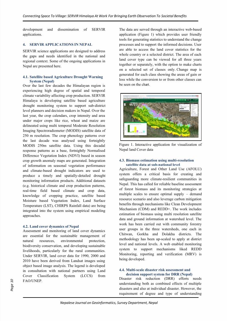
4.2.
Land cover dynamics of Nepal
Assessment and monitoring of land cover dynamics
are essential for the sustainable management of
natural resources, environmental protection,
biodiversity conservation, and developing sustainable
livelihoods, particularly for the rural communities.
Under SERVIR, land cover data for 1990, 2000 and
2010 have been derived from Landsat images using
object based image analysis. The legend is developed
in consultation with national partners using Land
Cover Classification System (LCCS) from
FAO/UNEP.
The data are served through an interactive web-based
application (Figure 1) which provides user friendly
tools for generating statistics to understand the change
processes and to support the informed decisions. User
are able to access the land cover statistics for the
whole country or a selected district. The area of eachland cover type can be viewed for all three years
together or separately, with the option to make charts
on a selected set of classes only. Change map is
generated for each class showing the areas of gain or
loss while the conversion to or from other classes can
be seen on the chart.
Figure 1. Interactive application for visualization of
Nepal land Cover data
4.3. Biomass estimation using multi-resolution
satellite data at sub-national level
Agriculture, Forest and Other Land Use (AFOLU)system offers a critical basis for creating and
safeguarding more climate-resilient communities in
Nepal. This has called for reliable baseline assessment
of forest biomass and its monitoring strategies at
multiple scales to ensure optimal supply – demand
resource scenario and also leverage carbon mitigation
benefits through mechanisms like Clean Development
Mechanism (CDM) and REDD+. The work includes
estimation of biomass using multi resolution satellite
data and ground information at watershed level. The
work has been carried out with community forestryuser groups in the three watersheds, one each in
Chitwan, Gorkha and Dolakha districts. The
methodology has been up-scaled to apply at district
level and national levels. A web enabled monitoring
system to support mechanisms liked REDD
Monitoring, reporting and verification (MRV) is
being developed.
4.4. Multi-scale disaster risk assessment and
decision support system for DRR (Nepal)
Disaster risk reduction (DRR) efforts needs
understanding both as combined effects of multiple
disasters and also at individual disaster. However, the
requirement of degree and type of understanding
8/17/2019 Nepalese Journal on Geo-informatics Number 14
http://slidepdf.com/reader/full/nepalese-journal-on-geo-informatics-number-14 21/65
Connecting Space To Village: SERVIR Himalaya At Work For Bringing Earth Observation To Societal Benefits
Nepalese Journal on Geoinformatics, Survey Department, Nepal
1 1
varies as a function of scale at which DRR
management options are operated. A framework
consisting of broad information on multiple disasters
at national level and detailed information on specific
disasters at vulnerable zones would help better
preparedness towards disaster risk management. Amultilevel hazard and risk analysis system is being
developed through wider stakeholder consultation. A
decision support system is also being developed by
integrating the data and information to aid in decision
making for managing flood hazard and associated risk
in Nepal.
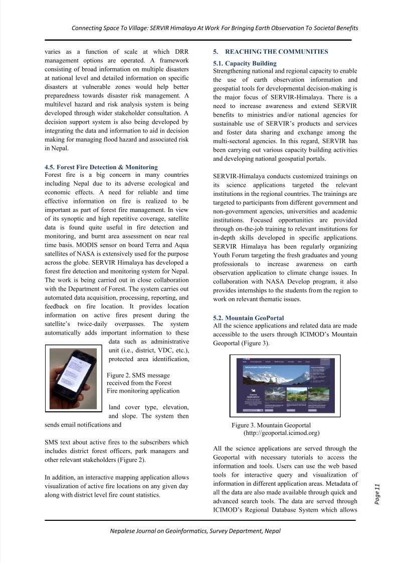
4.5. Forest Fire Detection & Monitoring
Forest fire is a big concern in many countries
including Nepal due to its adverse ecological and
economic effects. A need for reliable and time
effective information on fire is realized to be
important as part of forest fire management. In view
of its synoptic and high repetitive coverage, satellite
data is found quite useful in fire detection and
monitoring, and burnt area assessment on near real
time basis. MODIS sensor on board Terra and Aqua
satellites of NASA is extensively used for the purpose
across the globe. SERVIR Himalaya has developed a
forest fire detection and monitoring system for Nepal.
The work is being carried out in close collaboration
with the Department of Forest. The system carries out
automated data acquisition, processing, reporting, and
feedback on fire location. It provides location
information on active fires present during the
satellite’s twice-daily overpasses. The system
automatically adds important information to these
data such as administrative
unit (i.e., district, VDC, etc.),
protected area identification,
land cover type, elevation,
and slope. The system then
sends email notifications and
SMS text about active fires to the subscribers which
includes district forest officers, park managers and
other relevant stakeholders (Figure 2).
In addition, an interactive mapping application allows
visualization of active fire locations on any given day
along with district level fire count statistics.
5. REACHING THE COMMUNITIES
5.1. Capacity Building
Strengthening national and regional capacity to enable
the use of earth observation information and
geospatial tools for developmental decision-making is
the major focus of SERVIR-Himalaya. There is aneed to increase awareness and extend SERVIR
benefits to ministries and/or national agencies for
sustainable use of SERVIR’s products and services
and foster data sharing and exchange among the
multi-sectoral agencies. In this regard, SERVIR has
been carrying out various capacity building activities
and developing national geospatial portals.
SERVIR-Himalaya conducts customized trainings on
its science applications targeted the relevant
institutions in the regional countries. The trainings aretargeted to participants from different government and
non-government agencies, universities and academic
institutions. Focused opportunities are provided
through on-the-job training to relevant institutions for
in-depth skills developed in specific applications.
SERVIR Himalaya has been regularly organizing
Youth Forum targeting the fresh graduates and young
professionals to increase awareness on earth
observation application to climate change issues. In
collaboration with NASA Develop program, it also
provides internships to the students from the region to
work on relevant thematic issues.
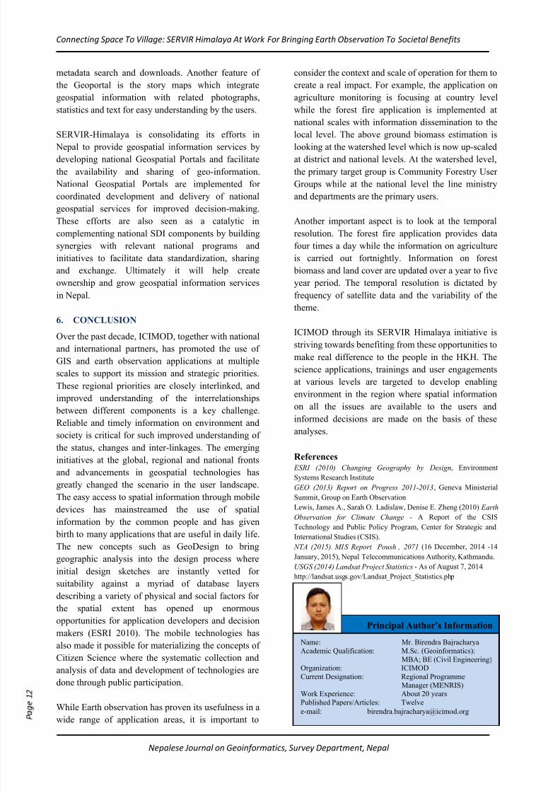
5.2. Mountain GeoPortal
All the science applications and related data are made
accessible to the users through ICIMOD’s Mountain
Geoportal (Figure 3).
All the science applications are served through the
Geoportal with necessary tutorials to access the
information and tools. Users can use the web based
tools for interactive query and visualization of
information in different application areas. Metadata of
all the data are also made available through quick andadvanced search tools. The data are served through
ICIMOD’s Regional Database System which allows
Figure 2. SMS messagereceived from the Forest
Fire monitoring application
Figure 3. Mountain Geoportal(http://geoportal.icimod.org)
8/17/2019 Nepalese Journal on Geo-informatics Number 14
http://slidepdf.com/reader/full/nepalese-journal-on-geo-informatics-number-14 22/65
Connecting Space To Village: SERVIR Himalaya At Work For Bringing Earth Observation To Societal Benefits
Nepalese Journal on Geoinformatics, Survey Department, Nepal
metadata search and downloads. Another feature of
the Geoportal is the story maps which integrate
geospatial information with related photographs,
statistics and text for easy understanding by the users.
SERVIR-Himalaya is consolidating its efforts in Nepal to provide geospatial information services by
developing national Geospatial Portals and facilitate
the availability and sharing of geo-information.
National Geospatial Portals are implemented for
coordinated development and delivery of national
geospatial services for improved decision-making.
These efforts are also seen as a catalytic in
complementing national SDI components by building
synergies with relevant national programs and
initiatives to facilitate data standardization, sharing
and exchange. Ultimately it will help create
ownership and grow geospatial information services
in Nepal.
6. CONCLUSION
Over the past decade, ICIMOD, together with national
and international partners, has promoted the use of
GIS and earth observation applications at multiple
scales to support its mission and strategic priorities.
These regional priorities are closely interlinked, and
improved understanding of the interrelationships
between different components is a key challenge.
Reliable and timely information on environment and
society is critical for such improved understanding of
the status, changes and inter-linkages. The emerging
initiatives at the global, regional and national fronts
and advancements in geospatial technologies has
greatly changed the scenario in the user landscape.
The easy access to spatial information through mobile
devices has mainstreamed the use of spatial
information by the common people and has given
birth to many applications that are useful in daily life.
The new concepts such as GeoDesign to bring
geographic analysis into the design process where
initial design sketches are instantly vetted for
suitability against a myriad of database layers
describing a variety of physical and social factors for
the spatial extent has opened up enormous
opportunities for application developers and decision
makers (ESRI 2010). The mobile technologies has
also made it possible for materializing the concepts of
Citizen Science where the systematic collection and
analysis of data and development of technologies are
done through public participation.
While Earth observation has proven its usefulness in a
wide range of application areas, it is important to
consider the context and scale of operation for them to
create a real impact. For example, the application on
agriculture monitoring is focusing at country level
while the forest fire application is implemented at
national scales with information dissemination to the
local level. The above ground biomass estimation islooking at the watershed level which is now up-scaled
at district and national levels. At the watershed level,
the primary target group is Community Forestry User
Groups while at the national level the line ministry
and departments are the primary users.
Another important aspect is to look at the temporal
resolution. The forest fire application provides data
four times a day while the information on agriculture
is carried out fortnightly. Information on forest
biomass and land cover are updated over a year to five
year period. The temporal resolution is dictated by
frequency of satellite data and the variability of the
theme.
ICIMOD through its SERVIR Himalaya initiative is
striving towards benefiting from these opportunities to
make real difference to the people in the HKH. The
science applications, trainings and user engagements
at various levels are targeted to develop enabling
environment in the region where spatial information
on all the issues are available to the users and
informed decisions are made on the basis of theseanalyses.
References
ESRI (2010) Changing Geography by Design, Environment
Systems Research Institute
GEO (2013) Report on Progress 2011-2013, Geneva Ministerial
Summit, Group on Earth Observation
Lewis, James A., Sarah O. Ladislaw, Denise E. Zheng (2010) Earth
Observation for Climate Change - A Report of the CSIS
Technology and Public Policy Program, Center for Strategic and
International Studies (CSIS).
NTA (2015). MIS Report Poush , 2071 (16 December, 2014 -14
January, 2015), Nepal Telecommunications Authority, Kathmandu.USGS (2014) Landsat Project Statistics - As of August 7, 2014
http://landsat.usgs.gov/Landsat_Project_Statistics.php
Name: Mr. Birendra BajracharyaAcademic Qualification: M.Sc. (Geoinformatics);
MBA; BE (Civil Engineering)Organization: ICIMODCurrent Designation: Regional Programme
Manager (MENRIS)
Work Experience: About 20 yearsPublished Papers/Articles: Twelve
e-mail: [email protected]
Principal Author's Information
8/17/2019 Nepalese Journal on Geo-informatics Number 14
http://slidepdf.com/reader/full/nepalese-journal-on-geo-informatics-number-14 23/65
8/17/2019 Nepalese Journal on Geo-informatics Number 14
http://slidepdf.com/reader/full/nepalese-journal-on-geo-informatics-number-14 24/65
Education and Research Enhancement in Land Administration Sector at Kathmandu University
Nepalese Journal on Geoinformatics, Survey Department, Nepal
EDUCATION AND RESEARCH ENHANCEMENT IN
LAND ADMINISTRATION SECTOR AT
KATHMANDU UNIVERSITY
Mr. Subash Ghimire
Keywords: Education, Research, Land Administration, Kathmandu University
Abstract: This paper aims to strengthen the existing education and research in Land Administration and draw
attention of all national and international Land Administration community for their contributions to promote
education and research in Land Administration in developing countries such as Nepal. This paper also deals
with the challenges and opportunities in collaborative efforts made by KU and LMTC to become a leader in this
sector. The cost effective and reliable information is necessary for effective public service delivery. The economic
growth of any country involves the effective service delivery. This requires highly skilled and knowledgeable
human resources and output oriented research. To make land administration education, a leader course inNepal and also within the region in the future, KU has to overcome many challenges. Some challenges may be
addressed in the national level but some require collaborations and cooperation from international level.
Finally, Education and research in Land Administration sector helps to develop quality land administrational
professionals which in turn may incorporate the entire South Asia region as a potential Land Administration
market. KU is committed to develop a centre of excellence in Land Administration sector by providing quality
education and research.
1. INTRODUCTION:
Land Administration is a discipline that integratesdifferent land issues from different disciplines suchas legal, social, economic, technical, planning,
management and so on. The strengthening of Landadministration system is at high agenda of Nepalgovernment.The sufficient number of efficient land
professionals is required to fulfil this mission.However, there exist major gaps in providingeducation in all other aspects of land administrationand management. Moreover, in the scenario offederalism of the state, the country needs to developstrong land professionals. It is very important todevelop land professionals for the effectiveimplementation of recently formulated land use
policy. It is well known fact that today the Geomaticsand Land Administration field has become very
important as it is the program which deals with land.In context of Nepal, land issues are very critical andservice delivery in land is poor. Therefore, the
production of qualified human resources in this fieldis very important. Besides understanding the need ofhigher education in the land administration sectorsdue to lack of skilled and professional humanresources, there is necessity to conduct joint programfor enhancing research and education in landadministration sector.
Several Universities in United States, Europe andIndia are offering courses in Land Administration,
Surveying, mapping and Geomatics Engineering. Inthis context, Land Management Training Center(LMTC) and Kathmandu University(KU) have
already started the BE Geomatics Engineering in2007 and successfully running under the frameworkof Memorandum of understanding (MOU). KU andLMTC also share the physical boundary andresources to promote Geomatics Engineering andLand Administration courses. This course supportsthe further strengthening of the collaboration
between KU and LMTC.
Kathmandu University (KU) was established in November 1991 as an autonomous, non for profit,non-government, dedicated to maintain highstandards of academic excellence, public institutionthrough private initiative. The university iscommitted to develop leaders in professional areasthrough quality education with the vision “To
become a World Class University devoted to bringing knowledge and technology to the service ofmankind” . It is committed not only to developleaders in professional areas through qualityeducation but also develop as a centre of excellence.Long term presence of the university is also intendedto benefit the local communities in terms ofdevelopment of small scale business and communityservices.
Under the University there are seven schools: Schoolof Engineering, School of Management, School ofScience, School of Arts, School of Medical Sciences,School of Education and School of Law.
Departments are headed by school. Currently,Geomatics Engineering lies under the Department of
8/17/2019 Nepalese Journal on Geo-informatics Number 14
http://slidepdf.com/reader/full/nepalese-journal-on-geo-informatics-number-14 25/65
Education and Research Enhancement in Land Administration Sector at Kathmandu University
Nepalese Journal on Geoinformatics, Survey Department, Nepal
1
Civil and Geomatics Engineering within the umbrellaof School of Engineering of Kathmandu University.
Mainly LMTC under the Ministry of Land Reformand Management is established to produce the skilfulsurveying, mapping and land administration and
management professionals through trainings withinthe country. LMTC is offering two types of regularcourses and several short courses; Basic Surveycourse and Senior and Junior Survey course.Similarly, School of Geomatics which wasestablished in 1999 in affiliation to council fortechnical education and training (CTEVT) is a
private institution providing education in the field ofsurveying and mapping. Since its establishment, theschool has been working at human resourcedevelopment in the field of surveying and spatialinformation application at different levels. It isoffering Diploma in Survey Engineering, TSLC in
Survey Engineering (surveyor), and Short term andtailored made course on surveying/mapping, GIS,GPS and Land Information-system.
2. OBJECTIVES OF GEOMATICS
PROGRAM:
The main objectives of Geomatics program at KUare as follows• To produce undergraduate and graduate level
kae likyh ghqualified professionals in
the field of land Administration andmanagement.
• To conduct and promote research anddevelopment activities in the field of landadministration/ management.
3. STATUS OF UNDERGRADUATE
GEOMATICS ENGINEERING:
The undergraduate Geomatics engineering programwas started in August 2007. Total 102 students aregraduated as Geomatics Engineers and most of themare already employed in various government andnon-government institutions.
The first MOU between KU and LMTC under the
framework of which, the Geomatics program had been started was completed in 2011 and a secondMOU is completed with the intake of 2014 batch.Under first completed MOU, Ministry of LandReforms and Management have provided financialsupport for 7 years for four batches. In this case 75%of total fee is waived for 24 students. Similarly,under the framework of second MoU, the 2011,2012, 2013 and 2014 batch students are enrolled inthe course. The Ministry of Land Reform andManagement is providing scholarships under variouscategories to number of students. In the new MOU, a100% tuition fee is waived for two students fromgovernment employee in the engineering servicesunder survey group category, a 50% fee is waived foreight students from four Development Regions
except the central regions of Nepal and 33% oftuition fee is waived for 10 students passing theKathmandu University Common Admission Test(KU-CAT) entrance exam on merit basis.
4. EXISTING PHYSICAL FACILITIES:
The library facilities and sports facilities areavailable at KU and LMTC. The survey equipments,computer lab for remote Sensing and Geodesy areavailable at LMTC. Similarly, computer Lab forcomputer programming, GIS lab and conference labfor provision for e-learning are available at KU. Thecourse syllabus of BE Geomatics Engineering
program is consistently revised by the SubjectCommittee/Faculty board and academic council ofKU with due consideration of feedback from studentsand stakeholders including industries every year.This engineering program have strong component offield survey training equivalent to 4.5 months in 4years program and internship of one and half months.
5. GRADUATE PROGRAM IN LAND
ADMINISTRATION:
KU has also started two year’s master degree
program in 2013 in Land Administration incollaboration with LMTC and is successfully runningat KU. The main aim of starting the master in landAdministration course is to produce graduate levelhighly skilled and qualified professionals in the fieldof land Administration and to conduct and promoteresearch and development activities in the field of
land administration and management. The marketstudy was carried out in 2010 and implementation
plan was drafted in 2011 to start the master program.Land administration program at KU consists ofmultidisciplinary courses so that the intake will befrom multidisciplinary background. The Governmentof Nepal has approved 100% scholarship to 10candidates for government employee up to four
batches. The financial aid is also available toselective full paying students in the form of graduateteaching assistantships as per the requirement of theDepartment.
The 2013 batch students are in final semester and arecarrying out the Master research focussing on variousland issues. The Memorandum of Understanding(MOU) between Kathmandu University, School ofEngineering, Nepal and University of Twente,Faculty of Geo-Information Science and EarthObservation, the Netherlands had alreadybeen signedto run the Land Administration program.
6. RESEARCH ENHANCEMENT:
KU has given priority in the following areas ofresearch in Geomatics Engineering. They are remote
sensing, digital image processing, GeographicInformation System, physical Geodesy,Photogrammetry: Analytical, Digital and Closs
8/17/2019 Nepalese Journal on Geo-informatics Number 14
http://slidepdf.com/reader/full/nepalese-journal-on-geo-informatics-number-14 26/65
Education and Research Enhancement in Land Administration Sector at Kathmandu University
Nepalese Journal on Geoinformatics, Survey Department, Nepal
Range, GPS Surveys: Static, Differential and RealTime, Computer Cartography, Mobile Mapping,Land Administration and management. In thiscontext, KU has carrying out the research projecttitled Strengthening Geospatial Capacity building atKathmandu University in collaboration with
ICIMOD and includes following activities.
Activity1: Extending exchange program andinternship opportunities on five selected projects and
publishing story map through ArcGIS online. Thisactivity is successfully completed.
Activity2: Development of geo-enabled web andmobile applications and services through aconsortium of likeminded department, centres andinstitutions (Web-GIS based disaster impact andneed assessment)
Activity3: Advance research using remote sensingdata (Burnt Area Mapping Automation for theLandsat Using Python)
Similarly, the Geomatics Engineering program isalso carrying out the next project in collaborationwith ICIMOD titled Estimation of above ground
forest biomass and carbon stock using UAV images. In collaboration with OXFAM, GeomaticsEngineering program successfully completed projecton hydro – geological mapping of aquifers.
7. PROSPECTS OF THE PROGRAM:
KU has set vision for Geomatics program “To
become centre of excellence by providing qualityeducation and research for leadership in the Landsector with joint cooperation with government andother collaborating organisations”
Therefore, vision is categorized into short term andlong term. The short term vision is to continue theGeomatics Program with quality output. The longterm vision was to head towards research orientedMaster and PhD courses. Geomatics Engineering
program in KU and LMTC has set following future
plan to fulfil its vision:
• To start Diploma in Geomatics Engineering to produce operational level skilled humanresources.
• To start B. Tech (Ed) in Surveying.• To start MS by research in Land Administration
and management.• To enrol more PhD candidates in the field of
Land administration and management.• To emphasize the research projects in Land
Administration and management.• To strengthen and develop the intern opportunity
for Geomatics Engineering students in relatedindustries.
• To establish Geo Spatial Lab.
• To Establish CORS station within KU incollaboration with University of Tokyo.
• To carry out more research projects incollaboration with collaborating organisations.
8. MAJOR CHALLENGES:
The major challenges of undergraduate Geomatics
Engineering and Master Program in Land
Administration in Kathmandu University are
highlighted as follows.
• Infrastructure development• Physical facilities• Hardware and software
• Delivery of course• Faculty expansion
Visiting experts (national/international)
Transfer of LMTC officials• Knowledge exchange programs
• Enhancing private/ private and private/ publicunderstanding and support at both national andinternational level for running the program.
• Expansion of further higher education and jobmarket .
• Sustainability of the program.
9. OPPORTUNITIES:
There is an ample of opportunities for KU to become
a centre of excellence in Land Administration Sector.
Institutions like UT/ITC, ICIMOD, private and
government agencies are willing to support KU to
achieve its goal. KU has expectations for expert
advice from national and international land
administration community.
10. CONCLUSION:
The land issues are critical and service delivery inland is poor in many developing countries.Therefore, development of qualified humanresources in the field of Land Administration and
management become necessary. Land administrationand Geomatics Engineering has become emergingfield as it directly deals with surveying, mapping andland management. KU in collaboration with LMTCis playing crucial role for it. To become a centre ofexcellence in Nepal and also within the region in thefuture, KU has to grab the opportunities andovercome the challenges. Some of the abovementioned challenges could be addressed in nationallevel but some requires cooperation andcollaboration from the international level. Therefore,it is essential to draw attention of all national andinternational land administration and management
community for their contributions to promoteeducation and research in land administration sectorin developing countries such as Nepal.
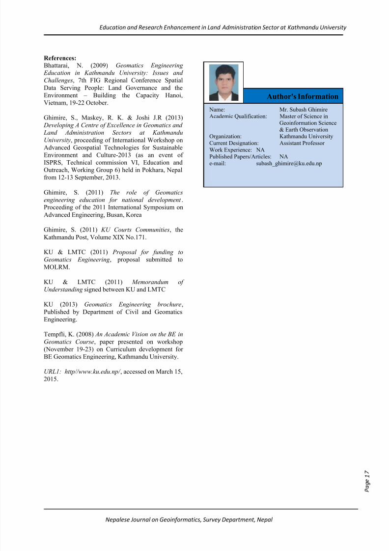
8/17/2019 Nepalese Journal on Geo-informatics Number 14
http://slidepdf.com/reader/full/nepalese-journal-on-geo-informatics-number-14 27/65
Education and Research Enhancement in Land Administration Sector at Kathmandu University
Nepalese Journal on Geoinformatics, Survey Department, Nepal
1
References:
Bhattarai, N. (2009) Geomatics Engineering
Education in Kathmandu University: Issues and
Challenges, 7th FIG Regional Conference SpatialData Serving People: Land Governance and the
Environment – Building the Capacity Hanoi,Vietnam, 19-22 October.
Ghimire, S., Maskey, R. K. & Joshi J.R (2013) Developing A Centre of Excellence in Geomatics and
Land Administration Sectors at Kathmandu
University, proceeding of International Workshop onAdvanced Geospatial Technologies for SustainableEnvironment and Culture-2013 (as an event ofISPRS, Technical commission VI, Education andOutreach, Working Group 6) held in Pokhara, Nepalfrom 12-13 September, 2013.
Ghimire, S. (2011) The role of Geomaticsengineering education for national development .Proceeding of the 2011 International Symposium onAdvanced Engineering, Busan, Korea
Ghimire, S. (2011) KU Courts Communities, theKathmandu Post, Volume XIX No.171.
KU & LMTC (2011) Proposal for funding to
Geomatics Engineering , proposal submitted toMOLRM.
KU & LMTC (2011) Memorandum of
Understanding signed between KU and LMTC
KU (2013) Geomatics Engineering brochure,Published by Department of Civil and GeomaticsEngineering.
Tempfli, K. (2008) An Academic Vision on the BE in
Geomatics Course, paper presented on workshop(November 19-23) on Curriculum development forBE Geomatics Engineering, Kathmandu University.
URL1: http//www.ku.edu.np/ , accessed on March 15,2015.
Name: Mr. Subash GhimireAcademic Qualification: Master of Science in
Geoinformation Science& Earth Observation
Organization: Kathmandu UniversityCurrent Designation: Assistant ProfessorWork Experience: NAPublished Papers/Articles: NAe-mail: [email protected]
Author's Information
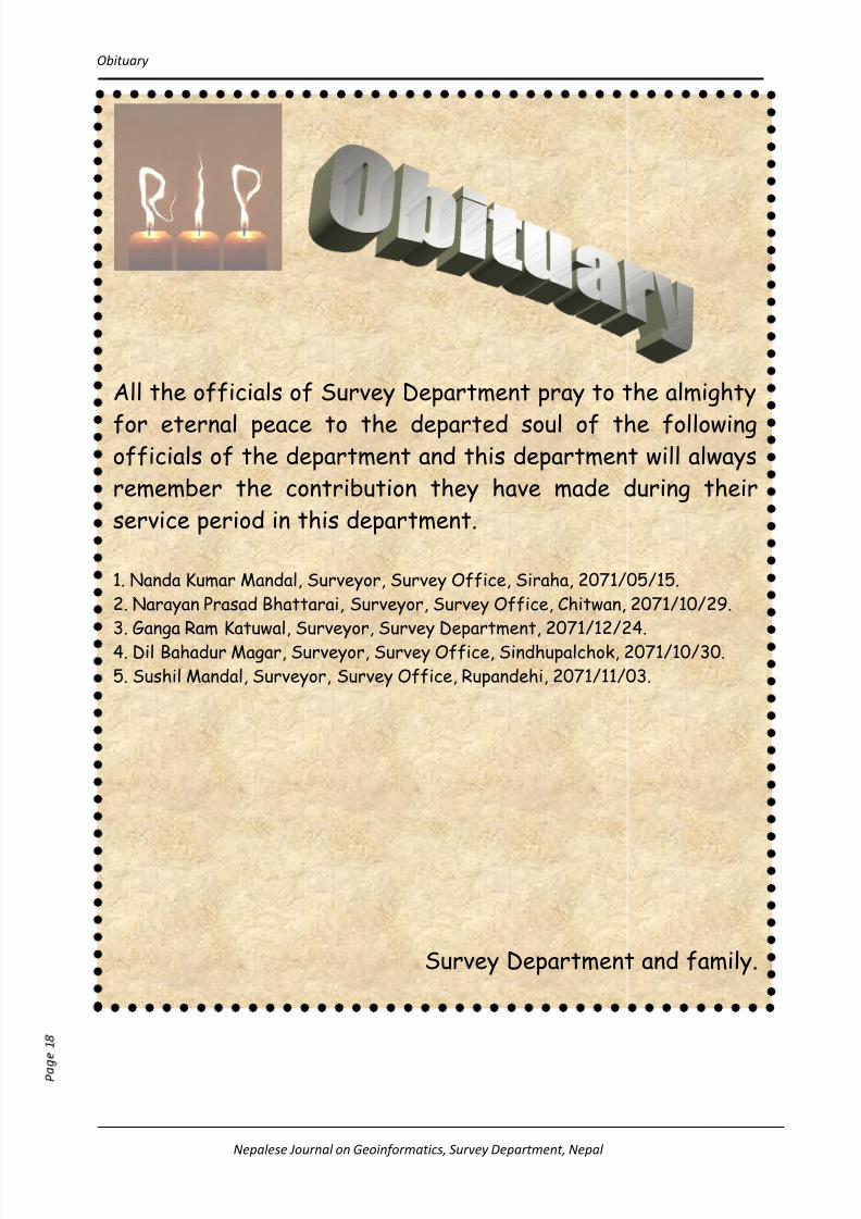
8/17/2019 Nepalese Journal on Geo-informatics Number 14
http://slidepdf.com/reader/full/nepalese-journal-on-geo-informatics-number-14 28/65
Obituary
Nepalese Journal on Geoinformatics, Survey Department, Nepal
All the officials of Survey Department pray to the almighty
for eternal peace to the departed soul of the followingofficials of the department and this department will always
remember the contribution they have made during their
service period in this department.
1. Nanda Kumar Mandal, Surveyor, Survey Office, Siraha, 2071/05/15.
2. Narayan Prasad Bhattarai, Surveyor, Survey Office, Chitwan, 2071/10/29.
3. Ganga Ram Katuwal, Surveyor, Survey Department, 2071/12/24.
4. Dil Bahadur Magar, Surveyor, Survey Office, Sindhupalchok, 2071/10/30.
5. Sushil Mandal, Surveyor, Survey Office, Rupandehi, 2071/11/03.
Survey Department and family.
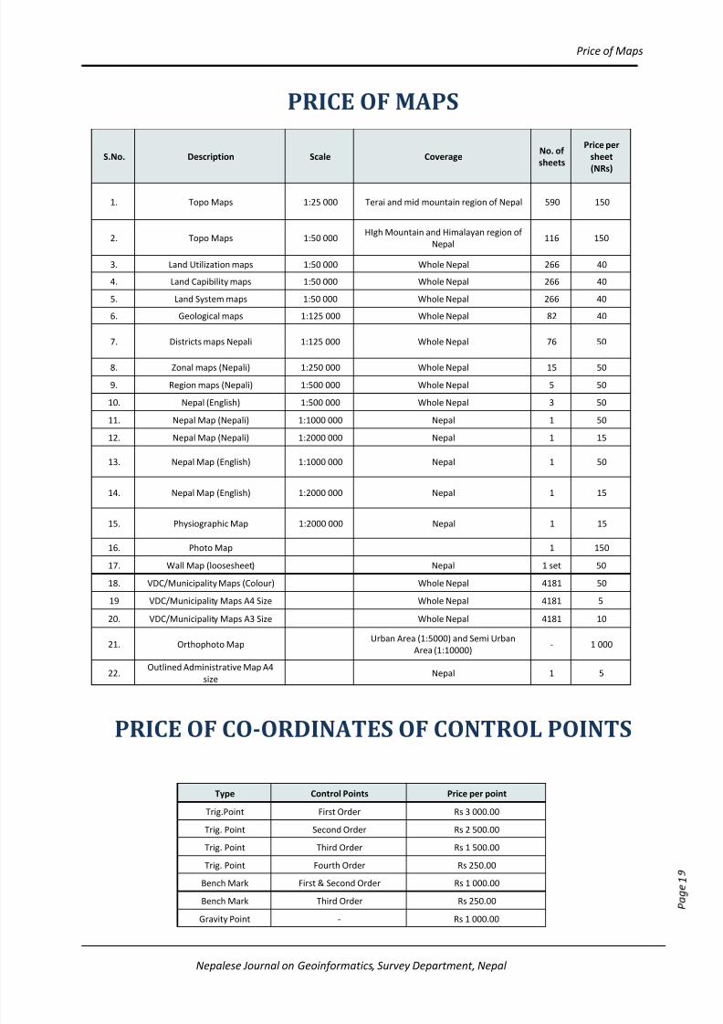
8/17/2019 Nepalese Journal on Geo-informatics Number 14
http://slidepdf.com/reader/full/nepalese-journal-on-geo-informatics-number-14 29/65
Price of Maps
Nepalese Journal on Geoinformatics, Survey Department, Nepal
1
PRICE OF MAPS
S.No. Description Scale CoverageNo. of
sheets
Price per
sheet
(NRs)
1. Topo Maps 1:25 000 Terai and mid mountain region of Nepal 590 150
2. Topo Maps 1:50 000HIgh Mountain and Himalayan region of
Nepal116 150
3. Land Utilization maps 1:50 000 Whole Nepal 266 40
4. Land Capibility maps 1:50 000 Whole Nepal 266 40
5. Land System maps 1:50 000 Whole Nepal 266 40
6. Geological maps 1:125 000 Whole Nepal 82 40
7. Districts maps Nepali 1:125 000 Whole Nepal 76 50
8. Zonal maps (Nepali) 1:250 000 Whole Nepal 15 50
9. Region maps (Nepali) 1:500 000 Whole Nepal 5 50
10. Nepal (English) 1:500 000 Whole Nepal 3 50
11. Nepal Map (Nepali) 1:1000 000 Nepal 1 50
12. Nepal Map (Nepali) 1:2000 000 Nepal 1 15
13. Nepal Map (English) 1:1000 000 Nepal 1 50
14. Nepal Map (English) 1:2000 000 Nepal 1 15
15. Physiographic Map 1:2000 000 Nepal 1 15
16. Photo Map 1 150
17. Wall Map (loosesheet) Nepal 1 set 50
18. VDC/Municipality Maps (Colour) Whole Nepal 4181 50
19 VDC/Municipality Maps A4 Size Whole Nepal 4181 5
20. VDC/Municipality Maps A3 Size Whole Nepal 4181 10
21. Orthophoto MapUrban Area (1:5000) and Semi Urban
Area (1:10000)- 1 000
22.Outlined Administrative Map A4
sizeNepal 1 5
PRICE OF CO-ORDINATES OF CONTROL POINTS
Type Control Points Price per point
Trig.Point First Order Rs 3 000.00
Trig. Point Second Order Rs 2 500.00
Trig. Point Third Order Rs 1 500.00
Trig. Point Fourth Order Rs 250.00
Bench Mark First & Second Order Rs 1 000.00
Bench Mark Third Order Rs 250.00
Gravity Point - Rs 1 000.00
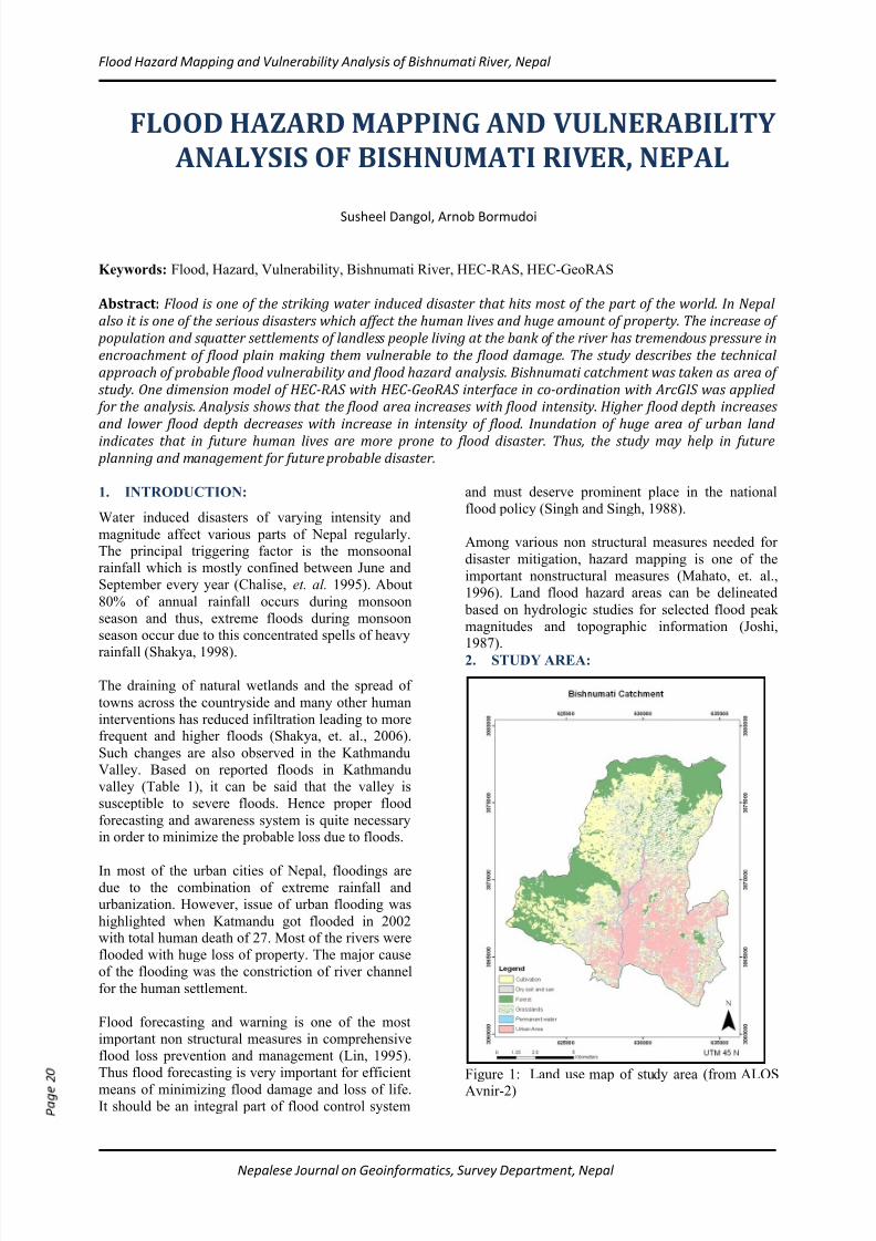
8/17/2019 Nepalese Journal on Geo-informatics Number 14
http://slidepdf.com/reader/full/nepalese-journal-on-geo-informatics-number-14 30/65
Flood Hazard Mapping and Vulnerability Analysis of Bishnumati River, Nepal
Nepalese Journal on Geoinformatics, Survey Department, Nepal
FLOOD HAZARD MAPPING AND VULNERABILITY
ANALYSIS OF BISHNUMATI RIVER, NEPAL
Susheel Dangol, Arnob Bormudoi
Keywords: Flood, Hazard, Vulnerability, Bishnumati River, HEC-RAS, HEC-GeoRAS
Abstract: Flood is one of the striking water induced disaster that hits most of the part of the world. In Nepal
also it is one of the serious disasters which affect the human lives and huge amount of property. The increase of
population and squatter settlements of landless people living at the bank of the river has tremendous pressure in
encroachment of flood plain making them vulnerable to the flood damage. The study describes the technical
approach of probable flood vulnerability and flood hazard analysis. Bishnumati catchment was taken as area of
study. One dimension model of HEC-RAS with HEC-GeoRAS interface in co-ordination with ArcGIS was applied
for the analysis. Analysis shows that the flood area increases with flood intensity. Higher flood depth increases
and lower flood depth decreases with increase in intensity of flood. Inundation of huge area of urban land
indicates that in future human lives are more prone to flood disaster. Thus, the study may help in future
planning and management for future probable disaster.
1. INTRODUCTION:
Water induced disasters of varying intensity andmagnitude affect various parts of Nepal regularly.The principal triggering factor is the monsoonalrainfall which is mostly confined between June andSeptember every year (Chalise, et. al. 1995). About80% of annual rainfall occurs during monsoonseason and thus, extreme floods during monsoonseason occur due to this concentrated spells of heavy
rainfall (Shakya, 1998).
The draining of natural wetlands and the spread oftowns across the countryside and many other humaninterventions has reduced infiltration leading to morefrequent and higher floods (Shakya, et. al., 2006).Such changes are also observed in the KathmanduValley. Based on reported floods in Kathmanduvalley (Table 1), it can be said that the valley issusceptible to severe floods. Hence proper floodforecasting and awareness system is quite necessaryin order to minimize the probable loss due to floods.
In most of the urban cities of Nepal, floodings aredue to the combination of extreme rainfall andurbanization. However, issue of urban flooding washighlighted when Katmandu got flooded in 2002with total human death of 27. Most of the rivers wereflooded with huge loss of property. The major causeof the flooding was the constriction of river channelfor the human settlement.
Flood forecasting and warning is one of the mostimportant non structural measures in comprehensiveflood loss prevention and management (Lin, 1995).Thus flood forecasting is very important for efficient
means of minimizing flood damage and loss of life.It should be an integral part of flood control system
and must deserve prominent place in the nationalflood policy (Singh and Singh, 1988).
Among various non structural measures needed fordisaster mitigation, hazard mapping is one of theimportant nonstructural measures (Mahato, et. al.,1996). Land flood hazard areas can be delineated
based on hydrologic studies for selected flood peakmagnitudes and topographic information (Joshi,1987).
2.
STUDY AREA:
Figure 1: Land use map of study area (from ALOS
Avnir-2)
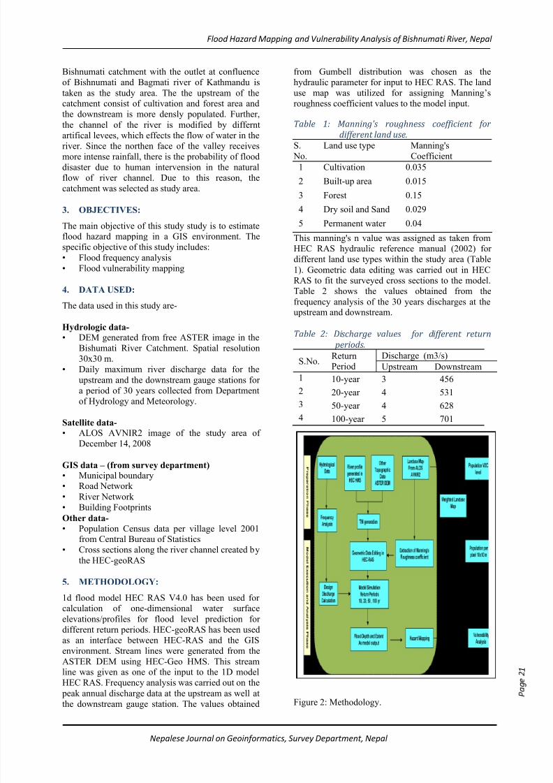
8/17/2019 Nepalese Journal on Geo-informatics Number 14
http://slidepdf.com/reader/full/nepalese-journal-on-geo-informatics-number-14 31/65
Flood Hazard Mapping and Vulnerability Analysis of Bishnumati River, Nepal
Nepalese Journal on Geoinformatics, Survey Department, Nepal
1
Bishnumati catchment with the outlet at confluenceof Bishnumati and Bagmati river of Kathmandu istaken as the study area. The the upstream of thecatchment consist of cultivation and forest area andthe downstream is more densly populated. Further,the channel of the river is modified by differnt
artifical levees, which effects the flow of water in theriver. Since the northen face of the valley receivesmore intense rainfall, there is the probability of flooddisaster due to human intervension in the naturalflow of river channel. Due to this reason, thecatchment was selected as study area.
3. OBJECTIVES:
The main objective of this study study is to estimateflood hazard mapping in a GIS environment. Thespecific objective of this study includes:• Flood frequency analysis• Flood vulnerability mapping
4. DATA USED:
The data used in this study are-
Hydrologic data-
• DEM generated from free ASTER image in theBishumati River Catchment. Spatial resolution30x30 m.
• Daily maximum river discharge data for theupstream and the downstream gauge stations fora period of 30 years collected from Departmentof Hydrology and Meteorology.
Satellite data-
• ALOS AVNIR2 image of the study area ofDecember 14, 2008
GIS data – (from survey department)
• Municipal boundary• Road Network• River Network• Building Footprints
Other data-
• Population Census data per village level 2001from Central Bureau of Statistics
• Cross sections along the river channel created bythe HEC-geoRAS
5. METHODOLOGY:
1d flood model HEC RAS V4.0 has been used forcalculation of one-dimensional water surfaceelevations/profiles for flood level prediction fordifferent return periods. HEC-geoRAS has been usedas an interface between HEC-RAS and the GISenvironment. Stream lines were generated from theASTER DEM using HEC-Geo HMS. This streamline was given as one of the input to the 1D model
HEC RAS. Frequency analysis was carried out on the peak annual discharge data at the upstream as well atthe downstream gauge station. The values obtained
from Gumbell distribution was chosen as thehydraulic parameter for input to HEC RAS. The landuse map was utilized for assigning Manning’s
roughness coefficient values to the model input.
Table 1: Manning's roughness coefficient for
different land use. S.
No.Land use type Manning's
Coefficient
1 Cultivation 0.035
2 Built-up area 0.015
3 Forest 0.15
4 Dry soil and Sand 0.029
5 Permanent water 0.04
This manning's n value was assigned as taken fromHEC RAS hydraulic reference manual (2002) fordifferent land use types within the study area (Table
1). Geometric data editing was carried out in HECRAS to fit the surveyed cross sections to the model.Table 2 shows the values obtained from thefrequency analysis of the 30 years discharges at theupstream and downstream.
Table 2: Discharge values for different return
periods.
S.No.ReturnPeriod
Discharge (m3/s)
Upstream Downstream
1 10-year 3 456
2 20-year 4 531
3 50-year 4 628
4 100-year 5 701
Figure 2: Methodology.
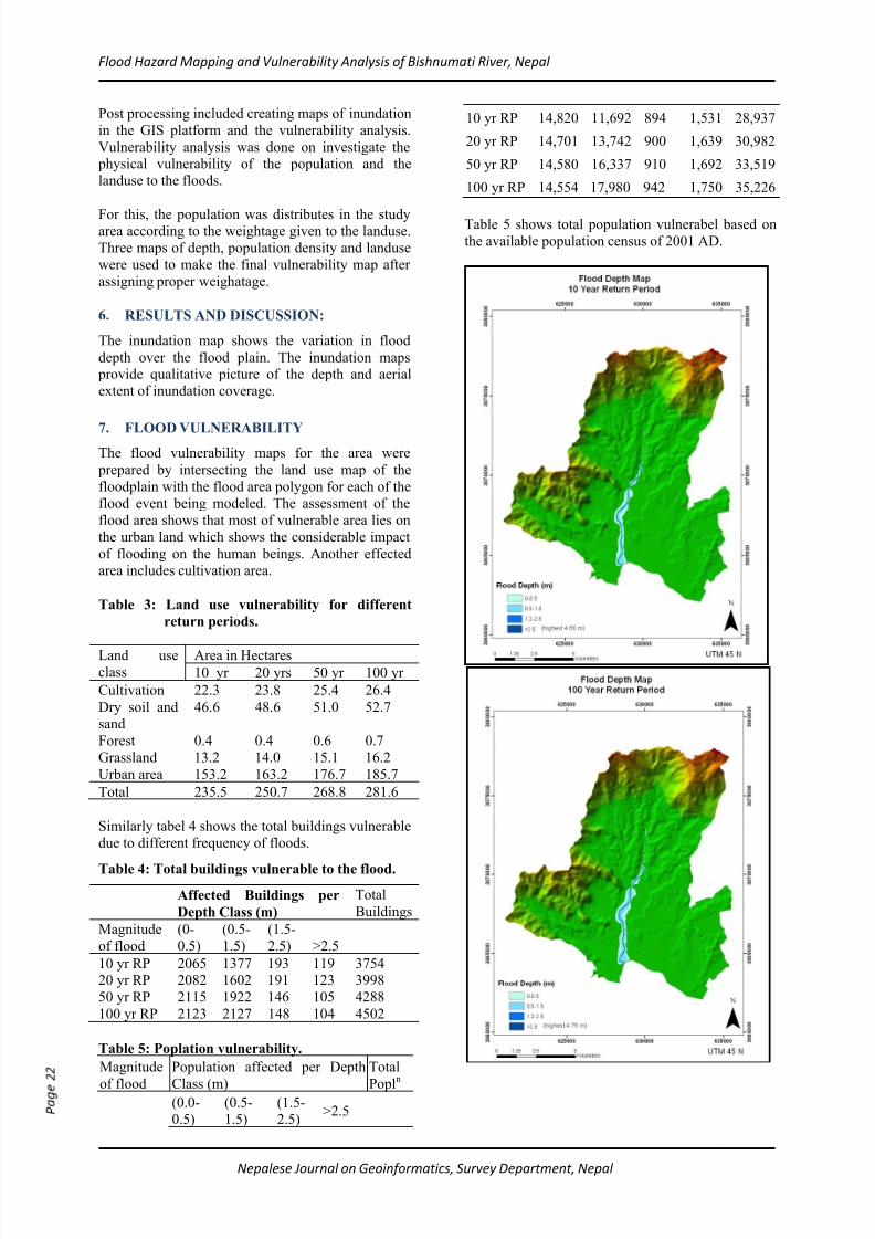
8/17/2019 Nepalese Journal on Geo-informatics Number 14
http://slidepdf.com/reader/full/nepalese-journal-on-geo-informatics-number-14 32/65
Flood Hazard Mapping and Vulnerability Analysis of Bishnumati River, Nepal
Nepalese Journal on Geoinformatics, Survey Department, Nepal
Post processing included creating maps of inundationin the GIS platform and the vulnerability analysis.Vulnerability analysis was done on investigate the
physical vulnerability of the population and thelanduse to the floods.
For this, the population was distributes in the studyarea according to the weightage given to the landuse.Three maps of depth, population density and landusewere used to make the final vulnerability map afterassigning proper weighatage.
6. RESULTS AND DISCUSSION:
The inundation map shows the variation in flooddepth over the flood plain. The inundation maps
provide qualitative picture of the depth and aerialextent of inundation coverage.
7.
FLOOD VULNERABILITYThe flood vulnerability maps for the area were
prepared by intersecting the land use map of thefloodplain with the flood area polygon for each of theflood event being modeled. The assessment of theflood area shows that most of vulnerable area lies onthe urban land which shows the considerable impactof flooding on the human beings. Another effectedarea includes cultivation area.
Table 3: Land use vulnerability for different
return periods.
Land useclass
Area in Hectares10 yr 20 yrs 50 yr 100 yr
Cultivation 22.3 23.8 25.4 26.4Dry soil andsand
46.6 48.6 51.0 52.7
Forest 0.4 0.4 0.6 0.7Grassland 13.2 14.0 15.1 16.2Urban area 153.2 163.2 176.7 185.7
Total 235.5 250.7 268.8 281.6
Similarly tabel 4 shows the total buildings vulnerabledue to different frequency of floods.
Table 4: Total buildings vulnerable to the flood.
Affected Buildings per
Depth Class (m)
TotalBuildings
Magnitudeof flood
(0-0.5)
(0.5-1.5)
(1.5-2.5) >2.5
10 yr RP 2065 1377 193 119 375420 yr RP 2082 1602 191 123 399850 yr RP 2115 1922 146 105 4288100 yr RP 2123 2127 148 104 4502
Table 5: Poplation vulnerability.
Magnitude
of flood
Population affected per Depth
Class (m)
Total
Popln
(0.0-0.5)
(0.5-1.5)
(1.5-2.5)
>2.5
10 yr RP 14,820 11,692 894 1,531 28,937
20 yr RP 14,701 13,742 900 1,639 30,982
50 yr RP 14,580 16,337 910 1,692 33,519
100 yr RP 14,554 17,980 942 1,750 35,226
Table 5 shows total population vulnerabel based onthe available population census of 2001 AD.
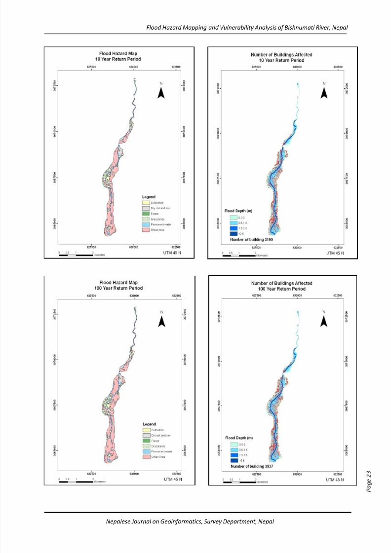
8/17/2019 Nepalese Journal on Geo-informatics Number 14
http://slidepdf.com/reader/full/nepalese-journal-on-geo-informatics-number-14 33/65
Flood Hazard Mapping and Vulnerability Analysis of Bishnumati River, Nepal
Nepalese Journal on Geoinformatics, Survey Department, Nepal
8/17/2019 Nepalese Journal on Geo-informatics Number 14
http://slidepdf.com/reader/full/nepalese-journal-on-geo-informatics-number-14 34/65
Flood Hazard Mapping and Vulnerability Analysis of Bishnumati River, Nepal
Nepalese Journal on Geoinformatics, Survey Department, Nepal
8. CONCLUSIONS / RECOMMENDATIONS:
The study shows the systematic process of preparation of flood vulnerability and hazard mapswith the application of one dimensional model HECRAS and ArcView with HEC-GeoRAS as interface
between two. The application of this models and procedure provide effective results within less timeconsumption and little resources. The result obtainedas graphical output (maps) from the model fordifferent return period of flood can help in decisionmaking.
The flood vulnerability was assessed with regard toland use pattern of the study area. It shows that huge
percentage of vulnerable area lies under urban area indifferent flood frequencies showing considerableimpact of flooding on the human beings of the area.Further, the analysis showed that maximum areaunder flood was between 0.5 to 1.5 meters for all thereturn periods.
Similarly, flood hazard assessment was also doneaccording to different return periods. The relation
between flood discharge and flooded area shows thatthere is increment of flooded area with increase indischarge. One of the biggest challanges remain hereis the generation of the precise DEM. In this studyfreely available ASTER DEM of 30m resolution has
been used which is not sufficient for hyrologicalmodelling in a small catchment like this.
Thus, availability of high resolution DEM isnecessary to get higher accurate results. This kind ofmodels are very useful and important for pre-
planning of disaster and also planning for proper landuse, land developement and settlement planning.
References:
Chalise, S. R., M. L. Shrestha and R.P. Nayaju, 1995.Rainfall as The Primary Indicator of Water InducedDisasters in Nepal. Proceeding of International
Seminar on Water Induced Disaster March 20-25,HMG/JICA.
Shakya, B., 1998. Problems Due to Some SevereFloods and Other Catastrophic Events AssociatedWith Synoptic Situation in Nepal. Polish Polar
Studies: 25th International Polar Symposium,
Warszawa 1998, P. Glowacki and J. Bednarek (Eds.),Institute of Geophysics of the Polish Academy ofSciences. Warsazawa pg 205-213.
Shakya, B., R. Ranjit, A. Shakya and S. Bajracharya,2006. Urban Flooding in Kathmandu Valley an floodEducation of People Living at the Flood Plains.
Journal of Hydrology and Meteorology 2006.
Lin, M. S., 1995. Flood Forecasting and WarningSystems in the ESCAP Region. Proceeding of
International Seminar on Water Induced Disaster ,March 20-25 HMG/JICA.
Singh, M. and K. N. Singh, 1988. Flood Hazards: A
Perspective on Their Control, Planning and
Management. Planning in Integrated Rural
Environment , Singh, R. Y. Singh and A. K. Singh(Eds), Deep and Deep publication, Delhi.
Mahato, R. C., D. Higaki, T. B. Thapa and N. P.Paudyal, 1996. Hazard Mapping Based on the Few
Case Studies in the Central Region of Nepal .Proceedings of An International Seminar on WaterInduced Disaster, Kathmandu, Nepal 26-29
November, pg 260.
Joshi, K. N., 1987. Satellite Remote Sensing and Its
Application in Flood Hazard - A Case Study inTransitional Zone (Luni Basin) of Great India.
Sharma, H. S., and M. L. Sharma, Environment Design and Development , Pg 478-484.
Name: Mr. Susheel DangolAcademic Qualification: Master of Science in
Geoinformation Science &
Earth ObservationOrganization: Survey DepartmentCurrent Designation: Chief Survey OfficerWork Experience: 8 yearsPublished Papers/Articles: Two
e-mail: [email protected]
Principal Author's Information

8/17/2019 Nepalese Journal on Geo-informatics Number 14
http://slidepdf.com/reader/full/nepalese-journal-on-geo-informatics-number-14 35/65
Calender of International Events
Nepalese Journal on Geoinformatics, Survey Department, Nepal
CALENDER OF INTERNATIONAL EVENTS
International workshop on the 'Role of Land
Professionals and SDI in Disaster Risk Reduction;
In the context of Post 2015 Nepal Earthquake"
Date: 25-27 November, 2015Country: Kathmandu, NepalEmail: [email protected]: www.workshopnepal2015.com.np Organizer: FIG, ISPRS, NRSPS, NICS.
FIG Working Week
Date: 17-21, May 2015Country: Sofia, BulgeriaEmail: [email protected]: www.fig.net Organizer: FIG
Geospatial World ForumDate: 25-29, May 2015Country: Lisbon, PortugalEmail: [email protected]:www. geospatialworldforum.orgOrganizer: Geospatial World Forum
International Forum on GNSS and LBS
Date: 24-26, June 2015Country: Shenzhen, ChinaEmail: [email protected]: www. its-expo.com
Group on Earth Observation (GEO) Planery
Date: 11-12, November 2015Country: Mexicon City, MexicoWebsite: www.earthobservations.org Organizer: GEO
27th International Cartographic Conference
Date: 23-28 August, 2015Country: Rio de Janeiro, BrazilEmail: [email protected]: www.icc2015.org Organizer: ICC
9th
International Society for Digital Earth
Date: 5- 9 October, 2015Country: Halifax, CanadaEmail: [email protected]: www.digitalearth-isde.org Organizer: ISDE
55th Photogrammetric Week Date: 7 - 11 Sept., 2015Country: Stuttgart, GermanyEmail: [email protected]: www.ifp.uni-stuttgart.de
Organizer: IFP
International Astronautical Federation
Date: 12 – 16 October, 2015Country: Jerusalem, IsraelWebsite: www.iafastro.org/iac-2015
Organizer: IAF
South Asia Geospatial Forum 2015
Date: 09 Feb, 2015Country: Hyderabad, IndiaEmail: [email protected]: www.indiageospatialforum.org Organizer: SAGF
36th Asian Conference on Remote Sensing
Date: 19-23 October, 2015Country: Quezon City, Philippines
Email: [email protected]: www.acrs2015.org Organizer: ACRS
ISPRS International Workshop on
Photogrammetric techniques for video
surveillance, biometrics and biomedicine
Date: 25-27 May, 2015Country: Moscow, RussiaEmail: [email protected]: www.isprs.org Organizer: ISPRS
8/17/2019 Nepalese Journal on Geo-informatics Number 14
http://slidepdf.com/reader/full/nepalese-journal-on-geo-informatics-number-14 36/65
Land Records Information Management System
Nepalese Journal on Geoinformatics, Survey Department, Nepal
LAND RECORDS INFORMATION MANAGEMENT
SYSTEM
Mr. Hira Gopal Maharjan
Keywords: e-Government, Land Information System, Land Records Information Management System,Architecture, Service Delivery.
Abstract: The land administration services are being provided using traditional methods and processes. The
record keeping system is mainly based on manual system so far. There is increasing need for efficient and
effective delivery of land administration services. Government organizations use Information and
Communication Technology to increase efficiency and effectiveness in the service delivery. E-Government can
bring improvement in efficiency, easy availability and accessibility of service and information to the citizens,
business organization, professional users as well as government organizations. The main aim of LRIMS is to
automate the land transaction related functions of Land Revenue Offices (LROs) based on different land
transactions process requirements.
The system is adherence to NeGIF and GEA, availability of intranet facility, provision of web-based system, and
data security. System modules show the modules needed for LIS. The implementation status of LIS in Nepal is in
initial stage. The old system architecture does not support the e-Government model. The system modules show
the modules needed for LRIMS. The system modules help in delivering service efficiently. The three tier system
architecture follows all three models of e-Government (G2G, G2B and G2C) and reduces corruption, increase
access to information and improve data quality.
1. BACKGROUND
The Land Information System (LIS) history of Nepalis more than a two decade long. The first LIS wasIntegrated Land Infor mation System Project ‘Bhu
Laxmi’, which was developed in 1991/92 but couldnot function in practice for long time. The differentapplication software were found that are used byLRO, SO and other organizations are discussed DLIS(District Land Information System, SAEx (SpatialApplication Extension), Plot Register ManagementSystem (PRMS), Image Reference ManagementSystem (IRMS), Parcel Editor, OSCAR (OpenSource Cadastre and Registration) SOLA Project.Regarding LIS Implementation Status, the data entryof DLIS has been started since F.Y. 2057/58 and
consequently all the LRO's data have been digitizedexcept Achham LRO likewise geo-database preparation in SAEx has been started since F.Y.2066/67 and consequently all SO's geo-database have
been prepared except Achham and Arghakhanchidistricts. According to "Doing Business Report,2015", Nepal's land registration is ranked at 27
th out
of 189 countries and 1st in South Asia and even 1 st intop ten services provided within our country
2. INTRODUCTION
It is an ADB granted ICT Development Project, oneof the components of e-Government applications
under Office of Prime Minister and Council ofMinisters of US $ 1.365 million. It was started inApril 28, 2013 A.D. and will end in May 2018 A.D.
(including Post Warranty Service). It is a web-basedsoftware solution developed and installed inGovernment Integrated Data Center (GIDC) under
Government Enterprise Architecture (GEA) and Nepal e-Government Interoperability Framework(NeGIF). This will meet the needs of the Departmentof Land Reform and Management (DOLRM), LandRevenue Offices (LROs) and other stakeholders.DOLRM, LROs and other stakeholders will accessthe application via WAN within Intranet. It covers
Non-spatial data at LROs only. The main aim of the project is to implement web-based centralized systemin GIDC & DOLRM for automating the 14 LROsactivities. The project sites are DOLRM, 14 LROs(Baglung, Banke, Bhaktapur, Biratnagar- Morang,Chabahil, Chitwan, Dhading, Dillibazar, Kalanki,
Kaski, Kavre, Lalitpur, Makawanpur and Parsa).
3. OBJECTIVE
To automate the land transaction relatedfunctions of Land Revenue Offices (LROs)
based on different land transactions processrequirements.
To make the information easily accessible toland owners and related authorities.
4. SYSTEM ARCHITECTURE OF LRIMS
The system architecture of LRIMS is designed with
the concept of three architecture:-One applicationServer, one web server and core based partitioneddatabase server hosted in GIDC. The backup servers
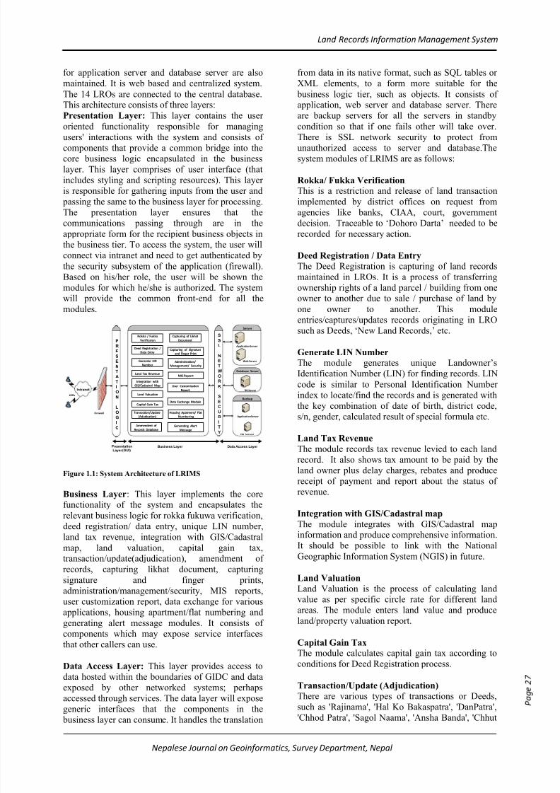
8/17/2019 Nepalese Journal on Geo-informatics Number 14
http://slidepdf.com/reader/full/nepalese-journal-on-geo-informatics-number-14 37/65
Land Records Information Management System
Nepalese Journal on Geoinformatics, Survey Department, Nepal
for application server and database server are alsomaintained. It is web based and centralized system.The 14 LROs are connected to the central database.This architecture consists of three layers:Presentation Layer: This layer contains the useroriented functionality responsible for managing
users' interactions with the system and consists ofcomponents that provide a common bridge into thecore business logic encapsulated in the businesslayer. This layer comprises of user interface (thatincludes styling and scripting resources). This layeris responsible for gathering inputs from the user and
passing the same to the business layer for processing.The presentation layer ensures that thecommunications passing through are in theappropriate form for the recipient business objects inthe business tier. To access the system, the user willconnect via intranet and need to get authenticated bythe security subsystem of the application (firewall).
Based on his/her role, the user will be shown themodules for which he/she is authorized. The systemwill provide the common front-end for all themodules.
Rokka / Fukka
Verificaion
S
SL
NET
WOR
K S
ECU
RIT
Y
PR
ESE
NTA
TIO
N L
O
GI
C
Deed Registration /
Data Entry
Generate LIN
Number
Land Tax Revenue
Integration with
GIS/Cadastral Map
Capturing of Likhat
Document
Capturing of Signature
and Finger Print
MIS Report
User Customization
Report
Data Exchange Module
Transaction/Update
(Adudication)
Capital Gain Tax
Ammendent of
Records Database
Administration/
Management/ Security
Generating Alert
Message
Housing Apatment/ Flat
Numbering
Server
Database Server
Backup
Intranet
PresentationLayer (GUI)
Business Layer Data Access Layer
Application Server
Web Server
DB Server
DB Sesrver
LROs
Application Server
Firewall
Land Valuation
Figure 1.1: System Architecture of LRIMS
Business Layer: This layer implements the corefunctionality of the system and encapsulates therelevant business logic for rokka fukuwa verification,deed registration/ data entry, unique LIN number,land tax revenue, integration with GIS/Cadastralmap, land valuation, capital gain tax,
transaction/update(adjudication), amendment ofrecords, capturing likhat document, capturingsignature and finger prints,administration/management/security, MIS reports,user customization report, data exchange for variousapplications, housing apartment/flat numbering andgenerating alert message modules. It consists ofcomponents which may expose service interfacesthat other callers can use.
Data Access Layer: This layer provides access todata hosted within the boundaries of GIDC and dataexposed by other networked systems; perhapsaccessed through services. The data layer will exposegeneric interfaces that the components in the
business layer can consume. It handles the translation
from data in its native format, such as SQL tables orXML elements, to a form more suitable for the
business logic tier, such as objects. It consists ofapplication, web server and database server. Thereare backup servers for all the servers in standbycondition so that if one fails other will take over.
There is SSL network security to protect fromunauthorized access to server and database.Thesystem modules of LRIMS are as follows:
Rokka/ Fukka Verification
This is a restriction and release of land transactionimplemented by district offices on request fromagencies like banks, CIAA, court, governmentdecision. Traceable to ‘Dohoro Darta’ needed to be
recorded for necessary action.
Deed Registration / Data Entry
The Deed Registration is capturing of land records
maintained in LROs. It is a process of transferringownership rights of a land parcel / building from oneowner to another due to sale / purchase of land byone owner to another. This moduleentries/captures/updates records originating in LROsuch as Deeds, ‘New Land Records,’ etc.
Generate LIN Number
The module generates unique Landowner’s
Identification Number (LIN) for finding records. LINcode is similar to Personal Identification Numberindex to locate/find the records and is generated withthe key combination of date of birth, district code,
s/n, gender, calculated result of special formula etc.
Land Tax Revenue
The module records tax revenue levied to each landrecord. It also shows tax amount to be paid by theland owner plus delay charges, rebates and producereceipt of payment and report about the status ofrevenue.
Integration with GIS/Cadastral map
The module integrates with GIS/Cadastral mapinformation and produce comprehensive information.It should be possible to link with the National
Geographic Information System (NGIS) in future.
Land Valuation
Land Valuation is the process of calculating landvalue as per specific circle rate for different landareas. The module enters land value and produceland/property valuation report.
Capital Gain Tax
The module calculates capital gain tax according toconditions for Deed Registration process.
Transaction/Update (Adjudication)
There are various types of transactions or Deeds,such as 'Rajinama', 'Hal Ko Bakaspatra', 'DanPatra','Chhod Patra', 'Sagol Naama', 'Ansha Banda', 'Chhut
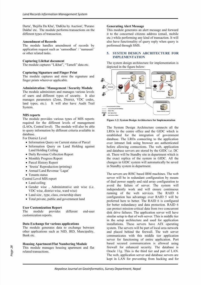
8/17/2019 Nepalese Journal on Geo-informatics Number 14
http://slidepdf.com/reader/full/nepalese-journal-on-geo-informatics-number-14 38/65
Land Records Information Management System
Nepalese Journal on Geoinformatics, Survey Department, Nepal
Darta', 'Bejilla Da Kha', 'DaKha by Auction', 'PuranoDakha' etc. The module performs transactions on thedifferent types of transaction.
Amendment of Records
The module handles amendment of records by
application request such as ‘samsodhan’ / ‘namasari’or other related tasks.
Capturing Likthat document
The module captures “Likhat”, “Tameli” data etc.
Capturing Signature and Finger Print
The module captures and store the signature andfinger prints wherever applicable.
Administration / Management / Security Module
The module administers and manages various levelsof users and different types of security. It also
manages parameters (Zone, District, VDC codes,land types, etc.). It will also have Audit TrailSystem.
MIS reports
The module provides various types of MIS reportsrequired for the different levels of management(LAOs, Central level). The module will also be ableto query information by different criteria available indatabase.For District Level
Information Query on Current status of Parcel
Information Query on Land Holding against
Land Holding Ceiling Daily Revenue Collection Report
Monthly Progress Report
Parcel History Report
‘Sresta’ Reproduction (printing)
Annual Land Revenue ‘Lagat’
Tenants statusCentral Level MIS report
Land ceiling
Gender wise , Administrative unit wise (i.e.VDC wise, district wise, ward wise)
Land size , type, class, ownership share
Total private, public and government land
User Customization Report
The module provides different end-usercustomization reports.
Data Exchange for various applications
The module generates data to exchange betweenother applications such as NID, IRD, Muncipality,Bank etc.
Housing Apartment/Flat Numbering ModuleThis module manages housing apartment and flatrelated transactions.
Generating Alert Message
This module generates an alert message and forwardit to the concerned citizens address (email, mobileetc.) while performing any kind of transaction. It willalso have functionality of query reply when query is
performed through SMS.
5. SYSTEM DESIGN ARCHITECTURE FOR
IMPLEMENTATION
The system design architecture for implementation isdepicted in the figure below:
Intranet
GIDC Department (Standby)
Connectivity with 1/1 Mbps
Connectivity with 10/10 Mbbps
Optical Fibre
Dark Optical Fibre
Land Revenue Offices
High End
Router
Low End
Router
Application Server
Database Server
Application Server
Web Server
Database ServerDisaster Recovery Site
NID, PSC,
DOTM etc.
Disaster Recovery Servers
High End Firewall
Low End Firewall
Web Server
Figure 1.2: System Design Architecture for Implementation
The System Design Architecture connects all theLROs to the centre office and the GIDC which isestablished for the integration of governmentdatabase. The LROs connecting to the applicationover intranet link using browser are authenticated
before allowing connections. The web, application
and database servers are stored by the GIDC i.e. DCsit. There will be Standby site in department which isthe exact replica of the system in GIDC. All thechanges in GIDC system will automatically be savedin Standby system in department.
The servers are RISC based IBM machines. The webserver will be in redundant configuration by meansof dual power supply and raid array configuration toavoid the failure of server. The system willindependently work and will ensure continuousrunning of the web services. The RAID 6configuration has advantage over RAID 5 will be
preferred here to better. The RAID 6 is configuredfor better redundancy and data protection. RAID 6can protect mission-critical data from two concurrentdisk drive failures. The application server will havesimilar setup to that of web server. This is middle tierin the setup architecture and used for applicationinstallations. These servers have AIX operatingsystem. The servers will be part of local area networkand placed behind the firewall. The web servercommunicates with this middle tier applicationserver for functioning of entire application. Port
based secured communication is allowed usingfirewall for enhanced security. The database isOracle 11g. This is the third tier and part of LAN.The web, application server and database servers arekept in LAN for preventing from hacking and for
8/17/2019 Nepalese Journal on Geo-informatics Number 14
http://slidepdf.com/reader/full/nepalese-journal-on-geo-informatics-number-14 39/65
Land Records Information Management System
Nepalese Journal on Geoinformatics, Survey Department, Nepal
better security. For data security the servers haveiptables as firewall and there is also a high endfirewall for more security. The technologies likecryptography, PKI, digital signature are used forsecurity purposes.
All the LROs access through the application at theGIDC. The users connect the web server which iskept in intranet via the intranet link. The web serverwill communicate with application server anddatabase server which are kept in LAN. The GIDChas dual high connectivity internet link and dualelectrical feeder. The connectivity of LROs withGIDC is via 1/1Mbps intranet link. The connectivityof department to GIDC is dual. The primary link isdark optical fiber and secondary link is 10/10 Mbpsdedicated optical fiber intranet link for continuousdata replication to occur in the severs located atdepartment. However, this connectivity is only for
the initial stage and will be increased in future. Theconcept of DR site for whole GIDC has also beeninitiated and feasibility study for this has been doneand proposed for Hetauda DR site with the aid fromKOICA. So, the system will have high availability.
The GIDC will be connected to disaster recovery andthe backup of all the servers in GIDC will bemaintained in disaster recovery site. There is highend firewall for the authentication process in GIDCand low end firewall in department. The webinterface will feature single sign on andauthentication system to prevent unauthorized
access.
If the system in GIDC fails, the standby system indepartment will take over the system. It is designedin such a way that the entire setup will be located in acentral location and the data will be accessed overthe intranet link from anywhere, the entire solution isweb based thus providing unhindered accessibilityand ease of use.
6. WORKING PROCEDURE OF LRIMS
APPLICATION
The working procedure of LRIMS application is asfollows:
Super Administrator: Manage the overall system
Local Administrator: User Management,Valuation Mgmt. & Report Generation etc.
Service Desk: Form fill up, upload document, photo, thumb & signature capture and formsubmission.
Junior Officer: Verify the form contents withattached document including online verification,issue letter for parcel split, public notice, collectsrevenue if no bank is available, generate LOCetc.
Bank Officer: Cash in and receive revenue.Submit collection report to LRO
Land Revenue Officer: Verify and approve theapplication/form, forward application/form toCLRO / backward to lower level
Chief Land Revenue Officer: Verify and approve theapplication/form, forward application/form toDOLRM for suggestion / backward to lower level
7. FEATURES OF LRIMS APPLICATION:
The Front-end (Programming Language) is inJava.
A web based application based on GEA(Government Enterprise Architecture ), SOAand NeGIF (Nepal e-GovernmentInteroperability Framework)
Bilingual-Developed in English and Nepali(Unicode)
Centralized system and standby backup(DOLRM and GIDC)
24x7 (24 hours, 7 days a week) serviceavailability
Accessible throughout the worldwideweb(www.nepal.gov.np) and a land owner can checkhis/her application status, own property detailsand can lodge application from own place infuture
An application can be lodged into a LRO fromother service desk/center for a transaction(Bejilla)
Secure (Thumb verification, Photo & Signaturecapture, User & Password) and transparenttransaction maintaining history of each activity
Automation of functions of LROs, Land Reformoffices and Guthi offices making working
procedure uniform throughout the country
Introduction of paper less system
Automatic valuation & tax management
Provide an Integrated Land OwnershipCertificate (LOC).
Land ceiling and Rokka can be automaticallyverified by system
Generation of different types of LIN, LOC anddifferent types of Reports
Alert message to the registered mobile/email.
Fields of forms are configurable (Mandatory andOptional)
Provision for online validation of thumbimpression, password, land parcel no., NID,PAN etc.
8. COMPARISON OF OLD SYSTEM AND
LRIMS ARCHITECTURE
Table 1.1: Comparison of old system and LRIMS Architecture
S.N. Parameters Old SystemArchitecture
LRIMSArchitectur e
1. Architecture Client server(2 – tiered)
3-tiered
8/17/2019 Nepalese Journal on Geo-informatics Number 14
http://slidepdf.com/reader/full/nepalese-journal-on-geo-informatics-number-14 40/65
8/17/2019 Nepalese Journal on Geo-informatics Number 14
http://slidepdf.com/reader/full/nepalese-journal-on-geo-informatics-number-14 41/65
Land Records Information Management System
Nepalese Journal on Geoinformatics, Survey Department, Nepal
1
2015 (12th
edition). A World Bank Group Flagship
Report .
DOLIA, (2015) Implementation status of DLIS andSAEx. LIS Analysis and Coordination Section, 2015.
Maharjan, H.G. (2014) Designing Land InformationSystem Architecture and module for Nepal ,Purbanchal University, 2014.
Sah, S. (2015) Presentation on Online Service in
Land Administration. Paper presented at LandAdministration Workshop, Baneshwor, Nepal.
Name: Mr. Hira Gopal Maharjan
Academic Qualification: M.Sc. Information
System Engineering Organization: Department of Land
Reform and
Management Current Designation: Computer OfficerWork Experience: 9 yearsPublished Papers/Articles: NA
e-mail: [email protected]
Author's Information
8/17/2019 Nepalese Journal on Geo-informatics Number 14
http://slidepdf.com/reader/full/nepalese-journal-on-geo-informatics-number-14 42/65
Instruction And Guidelines For Authors Regarding Manuscript Preparation
Nepalese Journal on Geoinformatics, Survey Department, Nepal
INSTRUCTION AND GUIDELINES FOR AUTHORS
REGARDING MANUSCRIPT PREPARATION
Editorial Board reserves the right to accept, reject
or edit the article in order to conform to the journal
format.
The contents and ideas of the article are solely of
authors.
The article must be submitted in soft copy form on
CD in microsoft Word or compatible format or by
email.
Editorial Board has no obligation to print chart/figure/table in multi colour, in JPEG/TIFF format,
the figure/picture should be scanned in a high
resolution.
Authors are also requested to send us a written
intimation that the same articles is not sent for
publication in other magazine/journal.
Page size: A4
Format: Single line spacing with two columns.
Margin: upper 1", left 0.9", right 0.9", bottom 0.9".
Length of manuscript: The article should be limited
upto 6 pages.
Font: Times New Roman "10".
Title: The title should be centrally justified appearing
near top of 1st page in cambria, “20” point (Bold).
Authors Name: Authors name should be in Calibri
“10” with Upper and lower casing, centrally justified.
There should be a gap of two lines between the title
and author's name.
Author's Information: The author should provide
Name, Academic Qualification, Organization, Current
Designation, Work Experience (in years), Published
Papers/Article (Number), e-mail ID and scanned copy
of author's passport size photo.
Keywords: Four to five keywords on paper theme in
Times New Roman "10" with two spacing under the
Authors name.
Abstract: Single line spacing after keywords, limited
to around 300 words in Italic, Cambria “10”.
References: References should be listed in
alphabetical order at the end of paper in following
sequence and punctuation. Author’s last name,
Author’s initials, Year of publication, title of
references article in italic, name of book or journal,
volume number, country or city, name of publisher
etc.
Major heading (Level 1) should be flushed with theleft margin in Times New Roman “10” bold font and
with Upper casings. Color Dark blue. Numbering 1
Minor heading (Level 2) should be flushed with the
left margin in Times New Roman “10” Bold font and
with Upper and Lower Casing. Color Dark blue.
Numbering 1.1
Minor heading (Level 3) should be flushed with the
left margin in Times New Roman “10” Bold font,
Italic and with Upper and Lower Casing. Color Dark blue. Numbering 1.1.1
Minor heading (Level 4) should be flushed with the
left margin in Times New Roman “10” Italic and with
Upper and Lower Casing. Color Dark blue.
Numbering 1.1.1.1
BulletPoint:Use only (•).
Placement of photographs/tables: Photographs or
tables should be pasted in appropriate place ofmanuscript pages with caption in their positions in
Times new Roman ‘‘10” with Upper and lower
casing.
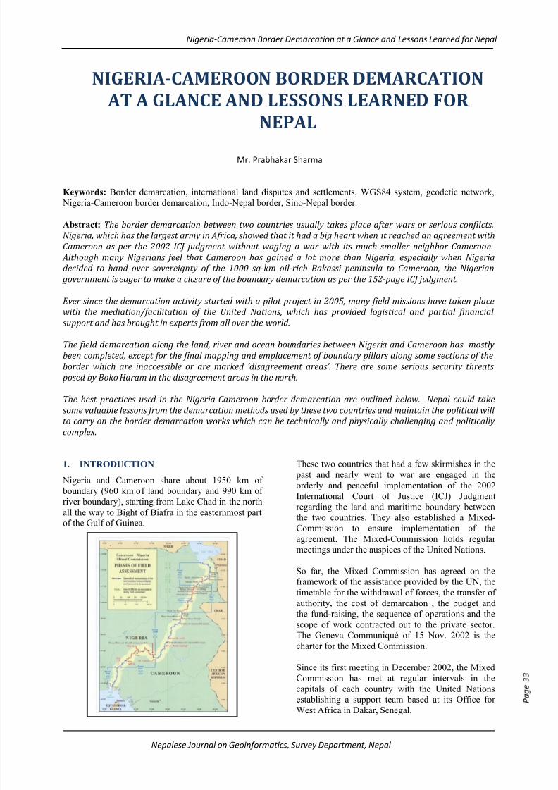
8/17/2019 Nepalese Journal on Geo-informatics Number 14
http://slidepdf.com/reader/full/nepalese-journal-on-geo-informatics-number-14 43/65
Nigeria-Cameroon Border Demarcation at a Glance and Lessons Learned for Nepal
Nepalese Journal on Geoinformatics, Survey Department, Nepal
NIGERIA-CAMEROON BORDER DEMARCATION
AT A GLANCE AND LESSONS LEARNED FOR
NEPAL
Mr. Prabhakar Sharma
Keywords: Border demarcation, international land disputes and settlements, WGS84 system, geodetic network, Nigeria-Cameroon border demarcation, Indo-Nepal border, Sino-Nepal border.
Abstract: The border demarcation between two countries usually takes place after wars or serious conflicts.
Nigeria, which has the largest army in Africa, showed that it had a big heart when it reached an agreement with
Cameroon as per the 2002 ICJ judgment without waging a war with its much smaller neighbor Cameroon.
Although many Nigerians feel that Cameroon has gained a lot more than Nigeria, especially when Nigeria
decided to hand over sovereignty of the 1000 sq-km oil-rich Bakassi peninsula to Cameroon, the Nigerian
government is eager to make a closure of the boundary demarcation as per the 152-page ICJ judgment.
Ever since the demarcation activity started with a pilot project in 2005, many field missions have taken place
with the mediation/facilitation of the United Nations, which has provided logistical and partial financial
support and has brought in experts from all over the world.
The field demarcation along the land, river and ocean boundaries between Nigeria and Cameroon has mostly
been completed, except for the final mapping and emplacement of boundary pillars along some sections of the
border which are inaccessible or are marked ‘disagreement areas’. There are some serious security threats
posed by Boko Haram in the disagreement areas in the north.
The best practices used in the Nigeria-Cameroon border demarcation are outlined below. Nepal could take
some valuable lessons from the demarcation methods used by these two countries and maintain the political willto carry on the border demarcation works which can be technically and physically challenging and politically
complex.
1. INTRODUCTION
Nigeria and Cameroon share about 1950 km of boundary (960 km of land boundary and 990 km ofriver boundary), starting from Lake Chad in the northall the way to Bight of Biafra in the easternmost partof the Gulf of Guinea.
These two countries that had a few skirmishes in the past and nearly went to war are engaged in theorderly and peaceful implementation of the 2002International Court of Justice (ICJ) Judgmentregarding the land and maritime boundary betweenthe two countries. They also established a Mixed-Commission to ensure implementation of theagreement. The Mixed-Commission holds regular
meetings under the auspices of the United Nations.
So far, the Mixed Commission has agreed on theframework of the assistance provided by the UN, thetimetable for the withdrawal of forces, the transfer ofauthority, the cost of demarcation , the budget andthe fund-raising, the sequence of operations and thescope of work contracted out to the private sector.The Geneva Communiqué of 15 Nov. 2002 is thecharter for the Mixed Commission.
Since its first meeting in December 2002, the MixedCommission has met at regular intervals in the
capitals of each country with the United Nationsestablishing a support team based at its Office forWest Africa in Dakar, Senegal.
8/17/2019 Nepalese Journal on Geo-informatics Number 14
http://slidepdf.com/reader/full/nepalese-journal-on-geo-informatics-number-14 44/65
Nigeria-Cameroon Border Demarcation at a Glance and Lessons Learned for Nepal
Nepalese Journal on Geoinformatics, Survey Department, Nepal
The peaceful withdrawal and transfer of authority ofover 30 villages in the Lake Chad area (in 2003) andalong the land boundary in 2004 took placesuccessfully under the supervision of United Nationscivilian observers who were overseeing all these
exercises.
The modalities governing the withdrawal andtransfer of authority in the Bakassi peninsula weresigned on 12 June 2006 in Greentree, New York.This agreement was signed by the presidents ofCameroon and Nigeria, the Secretary General andrepresentatives of five witness countries-France,Germany, United Kingdom and the United States and
by August 2006, as per the agreement, 80% of the peninsula was returned to Cameroonianadministration with full withdrawal of Nigeriantroops. The remaining 20% was handed over to
Cameroon in June 2010.
On 11th May 2007 an agreement was signed on thedelimitation of the maritime boundary. The objectiveof this mission was to survey selected physicalfeatures in order to geo-reference the chartcontaining the boundary line as defined by the ICJinto the WGS84 datum.
In addition, the direction of the Loxodrome whichforms the remainder of the maritime boundary up toits tri-point with Equatorial Guinea, was approvedand signed in August 2007.
Hence all the four sections of the ruling-Lake Chad,the land boundary, Bakassi peninsula and maritime
boundary- have been implemented peacefully.
2. SUB COMMISSION ON DEMARCATION
Alongside these more high profile legal and politicalissues, the process of demarcating the land boundaryhas continued with the Mixed Commissionestablishing a Sub-Commission on Demarcation(SCD) which in turn established a Joint TechnicalTeam (JTT). The JTT includes technical experts
from the UN, Cameroon and Nigeria responsible forcarrying out the physical demarcation of the land boundary.
3. PRELIMINARY MAPPING
131 preliminary map sheets to 1:50,000 scales were prepared from partially rectified SPOT5 satelliteimagery by the United Nations Cartographic section
based in New York. These map sheets, which covera 30-km corridor on either side of the land boundary,are used for planning and field reconnaissance.
These maps will be augmented at a later date from
the measurement of ground control points to fullyrectify the imagery, leading to the production of thefinal mapping including the agreed boundary line.
A provisional boundary line based upon thedelimitation instruments defined by the ICJ judgmentis shown on the maps in conjunction with the SPOTimagery. This provisional line helps the surveyor infollowing the general direction of the boundary.
4. FIELD ASSESSMENT
In the field assessment, which is carried by the JointTechnical Team (JTT) according to the TechnicalGuidelines, the boundary is demarcated afteragreeing on the location based on the terraindescribed in the ICJ judgment.
For each pillar location, a “pillar site template’ onland or "river site template" on the river bank or onan island in the river, is used. On each site template,the GPS coordinates (UTM) based on Trimble ProXRP with real time corrections from Omni-star arerecorded, description cards prepared and signed bythe delegations comprising of the UN, Nigerian andCameroonian representatives. In general, pillars are
placed at 500m intervals, increasing to 100 mintervals in towns and villages.
In areas of disagreement, ‘disagreement templates’with the comments of Nigerian or Cameroonianrepresentatives are signed. There are 2 disagreementtemplates for each pillar site. The areas ofdisagreement are then referred to the SCD/MixedCommission (MC) for a technical or even a politicaldecision.
The UN provides helicopter support for the fieldassessment for inaccessible areas.
5. GEODETIC NETWORK
It was decided by the Parties to use theinternationally-recognized WGS84 and UTM systemfor the land boundary work.
The Geodetic Network consists of the constructionand survey of 10 primary markers more or lessevenly spaced along the boundary in either country
along with 30 secondary markers located closer tothe boundary.
Primary markers were surveyed in 2007-2008 using
GPS to an accuracy of 0.010m ± 1.0ppm (max
error 0.100m) with the secondary markers to 0.020m
± 10.0ppm (max error 0.200m).
6. BOUNDARY PILLAR EMPLACEMENT
It is estimated that about 3000 pillars (500 primaryand 2500 secondary pillars) will be required to
complete the boundary. The primary pillars will beestablished at 5km intervals and the secondary pillars
8/17/2019 Nepalese Journal on Geo-informatics Number 14
http://slidepdf.com/reader/full/nepalese-journal-on-geo-informatics-number-14 45/65
Nigeria-Cameroon Border Demarcation at a Glance and Lessons Learned for Nepal
Nepalese Journal on Geoinformatics, Survey Department, Nepal
will be constructed every 100 (for built up areas) or500m.
The pillars will be constructed at the locationsidentified by the JTT during the field assessment.
7.
FINAL PILLAR SURVEY
Following the construction of the pillars each onewill be surveyed using DGPS(differential GPS) withthe geodetic network forming the control points forthe GPS survey. Each pillar will be surveyed to an
accuracy of 0.020 m± 10.0 ppm ( max error
0.200m).
A separate quality assurance contract will beundertaken to provide some assurance on the GPScomputations for the geodetic network and the finalsurvey.
8. FINAL MAPPING
The coordinates based on the final survey will be plotted on the rectified (using the ground controlsurvey) 1:50,000 mapping.
9. LESSONS LEARNED FROM NIGERIA-
CAMEROON BORDER DEMARCATION
APPLICABLE TO NEPAL-INDIA OR
NEPAL-CHINA BORDER DEMARCATION
AND MAINTENANCE
The Nigeria-Cameroon border demarcation activity
is viewed as one of the most successful on-goingdemarcation works in the world. It is, however, notwithout its own share of problems. The emplacementof pillars, especially along the northern Nigeria-Cameroon border, has been stalled because ofsecurity concerns due to Boko Haram. There are alsoissues related to the inaccessibility of the terrain. Theinaccessible areas, especially the high mountains ofAtlantica and Gotel ranges, were demarcated in theoffice and the templates with derived coordinates anddescription cards were signed based on DEMs(Digital Elevation Models) from satellite imagery.
Based on the experience of working for 8 years in theinternational border demarcation works along the
Nigeria-Cameroon border, the author proposes thefollowing:
The WGS 84 and UTM system is one that can
be used for border demarcation and
reconstruction works for the Nepal-India or
Nepal-China border with XRP Trimble GPS
units with Omni-star subscription to obtain real
time coordinates to successfully identify missing
pillars or to trace old river courses or for
densification of pillars along the boundary. The
XP Omni-star observation gives real time
coordinates with differential correction to sub-
decimeter accuracy in open areas. For forested
areas that do not have a clear line of sight to the
Omni-star satellites, the dual frequency
differential GPS (DGPS) method that uses a
base and a rover station should be used.
Nepal and India agreed to restart the stalled
border maintenance and restoration works
during Indian Prime Minister’s visit to Nepal in
the first week of August 2014. The border
demarcation between Nepal and India will soon
take place in a spirit of friendship and mutual
respect as the leaders of both countries have
shown the right political will to solve the border
issues. We share about 1808 km open border
with India with whom we have cultural,
religious, linguistic and traditional ties. We
should make concerted efforts to solve
remaining border issues between our two
countries.
As it is a well-known fact that boundarymaintenance and restoration are importantcontributors to continuous boundary stability,the GoN should establish well-funded National
and International Boundary Commissions tosolve the pending issues regarding national andinternational boundaries.
It is very important to establish map libraries
and archives of all the treaties, documents,
individual and mutual maps of the treaties, aerial
photographs, satellite imagery, articles by border
experts (geodesists, cartographers, mapping
experts and geographers) and politicians and
lawyers so that they can be studied before we
send in delegations at the international and
national levels for negotiations of international
or state boundaries.
The GoN and the boundary commissions should
send the technical and political experts to ferret
out from the archives of other countries
information regarding Nepal’s border during
British rule in India. The technical experts
should be sent on trainings both at the local and
international levels so that they can get the
technical know-how of the best practices in
border delimitation, demarcation, construction,
maintenance and restoration works. There
should also be transfer of local and international
knowledge gained by Nepali experts to the
8/17/2019 Nepalese Journal on Geo-informatics Number 14
http://slidepdf.com/reader/full/nepalese-journal-on-geo-informatics-number-14 46/65
Nigeria-Cameroon Border Demarcation at a Glance and Lessons Learned for Nepal
Nepalese Journal on Geoinformatics, Survey Department, Nepal
younger generation by organizing workshops
and seminars and paper presentation.
Nepal and India would benefit greatly if there is
a joint list of boundary coordinates in a common
geodetic system, such as the WGS 84 GPS
system which uses the UTM projection. It would
be advantageous for Nepal to establish a GPS
network all over the country so that it can be
used not just for engineering surveying works
and hydropower development but for boundary
demarcation works and a long-term monitoring
of the heights of Mount Everest and other high
mountain peaks by local and international
experts and researchers using different models
and technological developments.
References:Adler, R. (1995) Positioning and Mapping
International Land Boundaries, Boundary andTerritory Briefing 2(1), IBRU, Durham.
Anglo-German agreements of 11 March and 12 April
1913.
Brown, H. (1994) The Iraq-Kuwait Boundary
Dispute: Historical Background and the UN
Decisions of 1992 and 1993, IBRU Boundary andSecurity Bulletin 2(3), October 1994, 66-80.
Shrestha, B. N. (2009) Border Issues of Nepal .
Thapa, K. (2009) Nepal Must Fix Its Border Using
GPS Technology.
2002 ICJ judgment regarding the land and maritime
boundary between Nigeria and Cameroon.
Thomson-Marchland Declaration, 1929-1930 (incorporating the Moisel map of 1912).
Name: Mr. Prabhakar SharmaAcademic Qualification: MS Degree in GPS
Surveying; ME DegreeSurvey Engineering andApplied Geodesy
Organization: NACurrent Designation: NAWork Experience: 20 yearsPublished Papers/Articles: NA
e-mail: [email protected]
Author's Information
8/17/2019 Nepalese Journal on Geo-informatics Number 14
http://slidepdf.com/reader/full/nepalese-journal-on-geo-informatics-number-14 47/65
S in Geoinformatics Profession
Nepalese Journal on Geoinformatics, Survey Department, Nepal
S IN GEOINFORMATICS PROFESSION
Rabin K. Sharma
Keywords: SDI, GNSS, GEOSS, GIS, RS, GPS
Abstract: The researchers from the field of surveying, in which the first letter of the word surveying is “S”, is
always seeking to improve for efficient system. In the process of such development, geoinformatics word being
used instead of surveying and it covers wide range of technologies to collect, process, visualize, storage,
integrate and disseminate the data and information required for many applications to improve the livelihood of
the people. This article tried to identify such system related to the alphabet “S” .
1. INTRODUCTION:
S is a nineteenth alphabet in roman language and first
letter of word Surveying. This technology remainedstill for many decades; however, the techniques aremodified and improved for achieving high quality ofthe results. Surveying is an inevitable component fordeveloping the nation because no one can think ofdevelopment without the maps. Due to which manycountries established Survey organization and carriedout surveying for the preparation of several types ofmaps. One of the oldest surveying organizations isOrdnance Survey of Great Britain. During Britishregime in the world, number of countries establishedtheir own Surveying organization. For example:Survey of India, Survey of Sri Lanka, et cetera for
conducting surveying works for the preparation ofdifferent types of maps. Whereas in Nepal, althoughSurveying work was carried out in a very primitiveway since the Lichhibhi period, but formally SurveyDepartment was established in 2014 B.S.
Technological development is a continuous process,so the same principle holds in surveying sector aswell. Hence, scope of surveying is graduallyincreasing along with the technological developmentin this phenomenon and the word Geoinformatics isinvented to abreast the several phenomenon in thecourse of technological development of surveying,
such as Geographical Information System (GIS),Remote Sensing (RS) and Global Positioning System(GPS), Spatial Data Infrastructure (SDI), et cetera. Itis realized that although GIS, RS and GPS areapplied in their corresponding fields but these threetechnologies became inseparable and thus recognizedas 3S in the Geoinformatics communities.
One very important fact is that if s is added in mostof the noun words it will qualify as plural such asships, snakes, books, fruits, et cetera. Such practice is
being applied in different technological developmentnot in the sense of pluralism but combining different
systems either for the efficient performance of thesystem or for the societal benefits; for example,Global Navigation Satellite Systems (GNSS), Global
Earth Observation System of Systems (GEOSS), etcetera.
2. SPECIFICATION:
In the context of the article, the first terminology forthe surveying is the specification. When surveying isto be carried out, a document with detailed technicalinformation has to be prepared beforehand. Thedocument is termed as specification in which, datumto be used, method of survey to be adopted, type ofequipment to be used, accuracy to be achieved, etcetera need to be clearly mentioned. Similarly, forevery map series there should have its ownspecifications because the components of thespecifications for a particular series such as accuracystandards, map layout, map contents, et cetera may
vary according to its characteristics and need. Thecharacteristics and need of the map series could bedistinguished in terms of purpose and type or scale ofthe map.
Map specifications should be used as a guide and acontroller by the individuals involved in the mapping
process. Every individual should follow strictly theinstructions, standard limitations and constraintsoutlined in the specification in order to produce astandard product. Therefore, the specification should
be made available prior to the commencement of themapping. As the quality of the map is directly linked
with the standards and accuracy specified in thespecifications, therefore, it should be prepared insuch a way that the final product should reflect theobjectives of the map. The standards and accuracymentioned in the document should be compatiblewith the methodology, equipment and resources to beapplied for the map preparation.
3. SPACE SCIENCE:
Space science is being applied unknowingly evenduring ancient civilization period of humankind. Inthose periods, the Shepherds used the stars and
planets of the sky as their guide for the navigationand reaching their destinations. Now the importanceof the space science and technology was realized,hence so many activities are in the process of
8/17/2019 Nepalese Journal on Geo-informatics Number 14
http://slidepdf.com/reader/full/nepalese-journal-on-geo-informatics-number-14 48/65
S in Geoinformatics Profession
Nepalese Journal on Geoinformatics, Survey Department, Nepal
technological developments and number oforganizations established to promote and createawareness about the potential of the use of spacetechnology and space related products. So space hassupported directly or indirectly in human civilization.Using space science and technology, our quality of
lives being enhanced and also could supportsustainable development of our society.
The scientists of the world are trying continuously, tomake best use of the space to facilitate the bettermentof the life of the people. For instant: developedaircrafts to move from one place to another throughthe space, launched artificial satellites forestablishing communication between two personsstaying in different corners in the world, forecastingweather to facilitate their activities as per the weathercondition, and many more.
Space related applications revolutionized the survey profession. In the past, space related technology waslimited to finding out azimuth of a line and thelocation of the points by observing stars in the space.
Now due to availability of artificial satellites, somany new technologies have been evolved such asRemote Sensing technology, Global PositioningSystem technology, et cetera.
4. THREE Ses OF GEOINFORMATICS:
As mentioned above, in Geoinformatics, RemoteSensing (RS), Global Positioning System (GPS) andGeographical Information System (GIS) are referredto three Ss. Reason being, in most of the applicationin Geoinformatics, these three technologies could notset apart. In other words, they have to be applied asan integrated way in number of applications. Forexample to locate a car parking location in nearby
place when you are driving your vehicle, to spreadnet in the sea for fishing by locating the potentialfishing area, et cetera.
5. REMOTE SENSING (RS):
The first S of 3S is Remote Sensing and this word isinvented around 1961, originally to describe the topic
of the conference entitled “Remote Sensing orEnvironment” held at the University of Michigan in
1961. Remote Sensing deals with air or space borneimages created with devices other than conventionalcameras. In airborne system, data are collected fromthe sensors installed in an aircraft or in helicopterwhere as in space borne system data are collectedfrom the sensors installed in artificial satellites.Remote Sensing is characterized by satellites. Theyenforce a data transfer by telemetering rather than byfilm and the data collected from a distance aretermed as remotely sensed data.
Remote Sensing technology is being used formapping and interpretation of the features fordifferent purposes for instance; extraction of
geological features, land use features, forest relatedfeatures, et cetera.
6. GLOBAL POSITIONING SYSTEM (GPS)
The second S of 3S is Global Positioning System(GPS), also termed as Navigation System with Timeand Ranging which was developed for Navigation byUnited States of America (USA) in 1978. The system
provides the services for determination of threedimensional coordinate of the observation station andfor navigation in aviation, maritime and roadtransport using the signals received by the receiver atthe station from several satellites orbiting the Earth.In order to locate the position, the receiver shouldreceive signals from at least four satellites from aconstellation.
7. GEOGRAPHICAL INFORMATION
SYSTEM (GIS)
The third S of 3S is Geographical InformationSystem (GIS). There are so many versions ofdefinition of GIS, however, one of the definitionsgiven by Arnoff in 1989 is as follows:“Geographical Information System (GIS) is a
computer based system that provides four sets of
capabilities such as data input, data management
(data storage and retrieval), manipulation and
analysis, and data output to handle geo-referenced
data ".
8. SYSTEM DEVELOPMENT TREND:
The scientists, researchers and data developers arealways exploring to develop efficient, reliable, user’s
friendly and cost effective system. Recent trend insurvey profession in this perspective is developing asystem comprises of several similar systems or anintegrated multi system approach. Some of suchsystems are Global Navigation Satellites Systems(GNSS), Global Earth Observation System ofSystems (GEOSS), multi-sensors system, et cetera.In the following paragraphs some of such systemswill be briefly described.
9.
GLOBAL NAVIGATION SATELLITESYSTEMS (GNSS)
Due to growing applications, easy operationalsystem, high reliability in accuracy and affordablesystem in using GPS constellation of United States ofAmerica (USA); number of such constellationsemerged from different countries or group ofcountries with their corresponding limitations.Accordingly, the constellations are categorized intoGlobal constellation, Regional Constellation andSatellite Based Augmented System (SBAS).
In Global constellations, there are GPS from United
States of America, GLONASS from Russia, Galileofrom Europe and COMPASS/BEIDOU from China.In Regional Constellations there are QZSS from
8/17/2019 Nepalese Journal on Geo-informatics Number 14
http://slidepdf.com/reader/full/nepalese-journal-on-geo-informatics-number-14 49/65
S in Geoinformatics Profession
Nepalese Journal on Geoinformatics, Survey Department, Nepal
Japan and IRNSS from India. Similarly in SatelliteBased Augmented System from different countriesaround the world are also developed such as WASSfrom USA, MTSAS from Japan, EGNOS fromEurope, GAGAN from India and SDCM from Russia[5]. Some of these systems are fully operational and
some are partially operational and would be fullyoperational from the date announced by thecorresponding organizations.
In order to make use of these systems, a concept ofGlobal Navigation Satellite System (GNSS) wasdeveloped. In this system, satellites signals from thesatellites of any constellations mentioned abovecould be used not only for Positioning, Navigationsand Timing (PNT) but also for non PNT applicationssuch as to compute wind velocity, height of seawaves, et cetera. Based on this approach of GNSS,the users could use satellites from different
constellations at the same time and it believes thatusing this system, the users can be benefited in manyaspects such as a user can receive signals of at leastfour satellites at any time at any corners of the world.This will certainly save time for the observation andconsequently, will be cost effective without losingthe expected accuracy.
10. GLOBAL EARTH OBSERVATION
SYSTEM OF SYSTEMS (GEOSS)
An international organization named Group on EarthObservations (GEO) has initiated Global EarthObservation System of Systems (GEOSS). GEOSS is
being realized to provide benefits to humankindthrough the process of informing comprehensive andsustained Earth observations and in a coordinatedapproach. “GEOSS will build on and add value to
existing Earth-observation systems by coordinating
their efforts, addressing critical gaps, supporting
their interoperability, sharing information, reaching
a common understanding of user requirements, and
improving delivery of information to users”.
Information for Societal Benefits covered the sectorof Agriculture, Biodiversity, Climate, Disaster,Ecosystem, Energy, Health, Water and Weather [6].
11. SPATIAL DATA INFRASTRUCTURE
(SDI):
Spatial Data Infrastructure (SDI) is being developedas a tool for national spatial data collection, storage,
processing and dissemination. SDI is a basis ofnational information resources. Because the users cancollect, revise and manage data from its own end inreal time ensuring the information remains accurateand valuable. This broadens the importance of use ofgeo-spatial data beyond traditional users and bringsthem into mainstream of new technology. So, sharingof data between and within the organizations will be
possible after SDI system is in operation andinteroperability system will be focused in thedevelopment of National Spatial Data Infrastructure
(NSDI). This can further be inter-linked withRegional Spatial Data Infrastructure (RSDI) andeven in Global Spatial Data Infrastructure (GSDI)approach.
A good and reliable spatial and non-spatial data
related with NSDI are the prerequisite for theeffective and efficient decision making to addresssome of the major national issues of the Governmentsuch as poverty reduction, good governance, social
justice, environmental protection, sustainabledevelopment and gender equity, et cetera.
12. SPACE SCIENCE RELATED
ORGANIZATION:
In order to create awareness of usefulness of spacescience and technology for the society, severalnational, regional and international organizations areestablished. In Nepal, some of the nationalorganizations are Nepal Surveyor’s Association
(NESA), Nepal Remote Sensing andPhotogrammetric Society (NRSPS), NepalEngineer’s Association (NEA), and so on. Some of
the regional organizations are Asia Pacific RegionalSpace Agency Forum (APRSAF), Asian Associationon Remote Sensing (AARS), and similarly some ofthe international organizations are InternationalSociety for Photogrammetry and Remote Sensing(ISPRS), International Steering Committee forGlobal Mapping (ISCGM), International Federationof Surveyors (FIG), International Union of Geodesy(IUG), Group on Earth Observations (GEO) and soon. These organizations always organized events inregular basis in some parts of their working regionsfor promoting the applications of space technologies,informing achievements and status of latestdevelopment in space technology, increasing publicawareness of the societal benefits, et cetera. If wesurf the net for the calendar of events related to spacescience and technology, we can find some events aregoing to be held in one of the parts of the world insome days in every month throughout the year. So by
participation in some of the events one could gainlots of space related information, update the
knowledge and enhance the horizon of vision.
13. SERVICE DELIVERY:
Customer’s satisfaction during service delivery is themost crucial component of the Government. Thegovernment always attempts to improve servicedelivery system but due to lack of adequate resourcesand appropriate infrastructure the problem remains asineffective. Secondly, when a new minister orsecretary comes, she/he will change the previous
policy and mechanism. Therefore, in order toimprove the service delivery, there should becohesiveness in implementing the system. The
officials involved in service delivery should bemorally boosted and should be able to supplyreliable, accurate and appropriate information to the
8/17/2019 Nepalese Journal on Geo-informatics Number 14
http://slidepdf.com/reader/full/nepalese-journal-on-geo-informatics-number-14 50/65
S in Geoinformatics Profession
Nepalese Journal on Geoinformatics, Survey Department, Nepal
users. Furthermore, the process of delivery systemshould not be complicated rather it should motivatethe users to receive the information by themselves sothat they should not take help from the brokers. Themost importantly, the user should receive theirinformation within the reasonable time.
14. CONCLUSION:
There are so many terminologies in the field ofGeoinformatics which are related to the alphabet “S”.
However, discussion is made from the specificationof the mapping, space science technology, and thetrend towards the development in the space science.Some information is also provided to know theseveral national and international organizationsworking with the space science. Finally, a small hintis given about the status of the service delivery to thecustomers and the ways to be improved foreffectiveness in the delivery system.
References:
Sharma, R. K. (1993) An Approach to Prepare Map
Specification, (Mapping my Professional Journey2012, pp 185-189)
Sharma, R. K., Acharya B. R. (2004) Spatial Data Infrastructure for Prosperous Nepal , (Mapping myProfessional Journey 2012, pp 236-240)
Sharma, R. K. (2008) Profession and Professional
Organizations in Nepalese Context , (Mapping myProfessional Journey, 2012 pp 268-274)
Sharma, R. K. (2009) Gffk gS;f tyf hUuf k|zf;g ;DaGwLcGt/f{ li6«o k|j[lt (Mapping my Professional Journey2012, pp 164-167)
Sharma, R. K. (2013) GNSS in the Path of Using
Multi-GNSS; Earth Observation, Newsletter of NRSPS, Issue No. 5
www.earthobservations.org
Name: Mr. Rabin K. SharmaAcademic Qualification: M.Sc. Degree in
PhotogrammetryOrganization: Retired from the Government
service as Director General ofSurvey Department, Nepal.
Current Designation: President, NRSPSWork Experience: 39 yearsPublished Papers/Articles: About seventy
e-mail: [email protected]
Author's Information
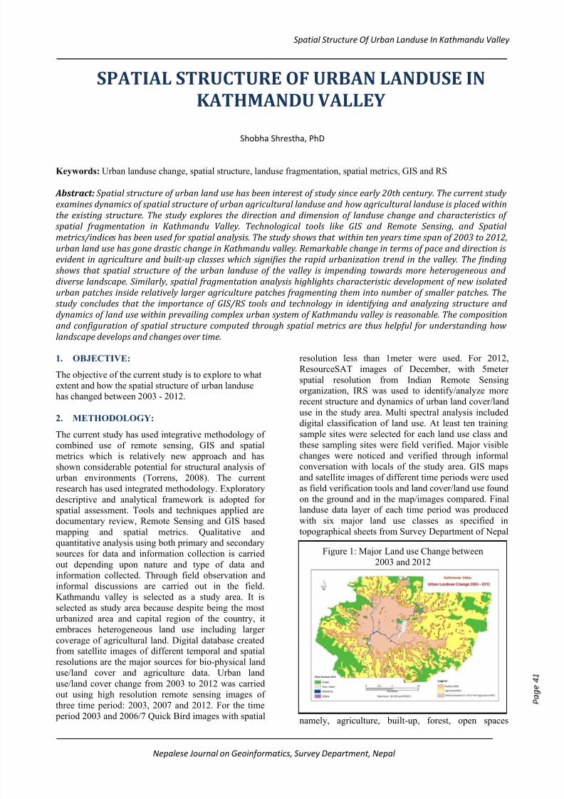
8/17/2019 Nepalese Journal on Geo-informatics Number 14
http://slidepdf.com/reader/full/nepalese-journal-on-geo-informatics-number-14 51/65
Spatial Structure Of Urban Landuse In Kathmandu Valley
Nepalese Journal on Geoinformatics, Survey Department, Nepal
SPATIAL STRUCTURE OF URBAN LANDUSE IN
KATHMANDU VALLEY
Shobha Shrestha, PhD
Keywords: Urban landuse change, spatial structure, landuse fragmentation, spatial metrics, GIS and RS
Abstract: Spatial structure of urban land use has been interest of study since early 20th century. The current study
examines dynamics of spatial structure of urban agricultural landuse and how agricultural landuse is placed within
the existing structure. The study explores the direction and dimension of landuse change and characteristics of
spatial fragmentation in Kathmandu Valley. Technological tools like GIS and Remote Sensing, and Spatial
metrics/indices has been used for spatial analysis. The study shows that within ten years time span of 2003 to 2012,
urban land use has gone drastic change in Kathmandu valley. Remarkable change in terms of pace and direction is
evident in agriculture and built-up classes which signifies the rapid urbanization trend in the valley. The finding
shows that spatial structure of the urban landuse of the valley is impending towards more heterogeneous and
diverse landscape. Similarly, spatial fragmentation analysis highlights characteristic development of new isolatedurban patches inside relatively larger agriculture patches fragmenting them into number of smaller patches. The
study concludes that the importance of GIS/RS tools and technology in identifying and analyzing structure and
dynamics of land use within prevailing complex urban system of Kathmandu valley is reasonable. The composition
and configuration of spatial structure computed through spatial metrics are thus helpful for understanding how
landscape develops and changes over time.
1. OBJECTIVE:
The objective of the current study is to explore to whatextent and how the spatial structure of urban landusehas changed between 2003 - 2012.
2.
METHODOLOGY:
The current study has used integrative methodology ofcombined use of remote sensing, GIS and spatialmetrics which is relatively new approach and hasshown considerable potential for structural analysis ofurban environments (Torrens, 2008). The currentresearch has used integrated methodology. Exploratorydescriptive and analytical framework is adopted forspatial assessment. Tools and techniques applied aredocumentary review, Remote Sensing and GIS basedmapping and spatial metrics. Qualitative andquantitative analysis using both primary and secondarysources for data and information collection is carriedout depending upon nature and type of data andinformation collected. Through field observation andinformal discussions are carried out in the field.Kathmandu valley is selected as a study area. It isselected as study area because despite being the mosturbanized area and capital region of the country, itembraces heterogeneous land use including largercoverage of agricultural land. Digital database createdfrom satellite images of different temporal and spatialresolutions are the major sources for bio-physical landuse/land cover and agriculture data. Urban landuse/land cover change from 2003 to 2012 was carriedout using high resolution remote sensing images ofthree time period: 2003, 2007 and 2012. For the time
period 2003 and 2006/7 Quick Bird images with spatial
resolution less than 1meter were used. For 2012,ResourceSAT images of December, with 5meterspatial resolution from Indian Remote Sensingorganization, IRS was used to identify/analyze morerecent structure and dynamics of urban land cover/landuse in the study area. Multi spectral analysis included
digital classification of land use. At least ten trainingsample sites were selected for each land use class andthese sampling sites were field verified. Major visiblechanges were noticed and verified through informalconversation with locals of the study area. GIS mapsand satellite images of different time periods were usedas field verification tools and land cover/land use foundon the ground and in the map/images compared. Finallanduse data layer of each time period was producedwith six major land use classes as specified intopographical sheets from Survey Department of Nepal
namely, agriculture, built-up, forest, open spaces
Figure 1: Major Land use Change between
2003 and 2012
8/17/2019 Nepalese Journal on Geo-informatics Number 14
http://slidepdf.com/reader/full/nepalese-journal-on-geo-informatics-number-14 52/65
Spatial Structure Of Urban Landuse In Kathmandu Valley
Nepalese Journal on Geoinformatics, Survey Department, Nepal
including barren land, water body and other whichincludes all except aforementioned classes. Land usechange analysis is carried out overlaying landuse datalayers and change from one class to another iscalculated and spatial analysis carried out based on theGIS output map and table.
Another tool used is spatial metrics for fragmentationand heterogeneity analysis. The spatial metrics isquantitative measures of spatial pattern andcomposition which describe the spatial heterogeneityfor each land use class. Spatial metrics derived fromsatellite imagery also help to describe themorphological characteristics of urban areas and theirchanges through time. Spatial metrics as discussed byEric J. Gustafson (1998) is used in this study foranalysis of spatial structural morphology andheterogeneity of urban land use in Kathmandu valleyduring different periods. The indices developed by
McGarigal (McGarigal et. al., 1995) used. Landscapelevel valley level for overall fragmentation andheterogeneity analysis and landuse individual classlevel analysis were carried out to quantify shape and
pattern of urban landuse in the study area whichmeasures fragmentation, dominance, proximity anddiversity. Selected spatial metrics includes spatialIndices measuring composition and spatialconfiguration. Composition is quantified, and isdescribed by:
(a) Number of landuse classes in the data/map, (b)Proportion of each class relative to the data/map, and
(c) Diversity which combines two components ofdiversity: richness, which refers to the number ofclasses present, and evenness, which refers to thedistribution of area among the classes.
Simpson's (Simpson, 1949) diversity index is exampleof such. The spatial configuration of structure
properties is much more difficult to quantify, andattempts have focused on describing spatialcharacteristics of individual patches (patch based) andthe spatial relationships among multiple patches(neighborhood based). Patch-based measures of patterninclude size, number, and density of patches. These
measures are calculated for all classes together or for a particular class of interest. Similarly, edge informationincludes various edges metric that incorporate thecontrast (degree of dissimilarity) between the patch andits neighbors.
3. OVERVIEW OF URBAN LAND USE
CHANGE 2003 -2012:
Number of studies focusing on urban land cover/landuse issues of Kathmandu valley has been carried outusing GIS and RS tools in different time period(Tamrakar, 1998; Koirala, 1999; Pradhan, 2001;
Paudel & Karki, 2005; Haack & Rafter, 2006; Hack,2009; Hack & Khatiwada, 2007; ICIMOD, 2007;Ghimire, 2008; Thapa & Murayama, 2009, 2010;
Zurick, 2010; Rimal, 2011). These studies showaccelerating urban growth of the valley resultingsignificant change in land use structure. Spatialexpansion of Kathmandu city from historical periodand change in morphological characteristics had also
been explored (Ranjitkar & Manandhar, 1981).
Directional expansion towards east and on patches asmultiple nuclei are major characteristics from 1846 to1964 whereas construction of road infrastructure(particularly Ring road) is characteristics after 1977causing overall change in morphological structure ofthe city.
Direction and dimension of change in land cover/ landuse class between 2003, 2007 and 2012 in Kathmanduvalley is shown in figure l and detailed in table 1.
The table reveals that within ten years time span landuse has gone drastic change. Remarkable change is
evident in agriculture and built-up classes whichsignifies the rapid urbanization trend in the valley.Agriculture land coverage has decreased from 52.5
percent to 44 percent whereas built-up area hasincreased from 23 percent to 31.5 percent. Ascompared to agriculture and built-up area, forest areahas remained relatively constant covering 22 percent ofthe valley. Major land use conversion observed duringall three period is agriculture and built up classes. Mostof the agriculture lands next to the core area followed
by surrounding agriculture area have been converted tourban built-up during the decadal period of 2003-2012.
Table 1: Kathmandu valley Landuse changeStatistics 2003 – 2012
SN Land useClass
2003(%)
2007(%)
2012(%)
1 Agriculture 52.58 46.58 44.70
2 Built up 23.25 29.59 31.54
3 Forest 22.61 22.35 22.20
4 Open Space 0.93 0.90 0.93
5 Water Body 0.15 0.12 0.15
6 Others 0.45 0.45 0.45
Total 99.98 99.98 99.97
Source: Calculated from GIS data (satellite image QB2003, 2007 and IRS 2012)
4. MORPHOLOGY AND STRUCTURE OF
URBAN LANDUSE: FRAGMENTATION
AND HETEROGENEITY ANALYSIS:
Spatial structure is a major subset of the concept ofspatial heterogeneity which refers to the spatialconfiguration of the landscape. In this section,morphological dynamics i.e. spatial fragmentation andheterogeneity analysis at landscape level (i.e.heterogeneity among all types of land use existingwithin the valley, which provides overview of spatialheterogeneity) is carried out for Kathmandu valley
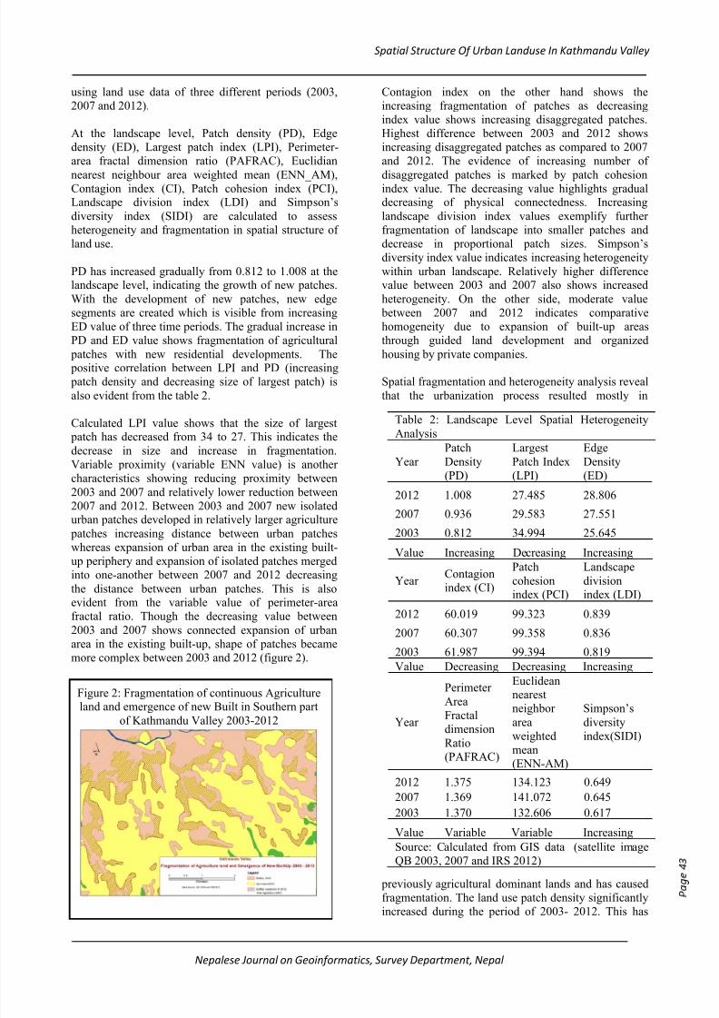
8/17/2019 Nepalese Journal on Geo-informatics Number 14
http://slidepdf.com/reader/full/nepalese-journal-on-geo-informatics-number-14 53/65
Spatial Structure Of Urban Landuse In Kathmandu Valley
Nepalese Journal on Geoinformatics, Survey Department, Nepal
using land use data of three different periods (2003,2007 and 2012).
At the landscape level, Patch density (PD), Edgedensity (ED), Largest patch index (LPI), Perimeter-area fractal dimension ratio (PAFRAC), Euclidian
nearest neighbour area weighted mean (ENN_AM),Contagion index (CI), Patch cohesion index (PCI),Landscape division index (LDI) and Simpson’s
diversity index (SIDI) are calculated to assessheterogeneity and fragmentation in spatial structure ofland use.
PD has increased gradually from 0.812 to 1.008 at thelandscape level, indicating the growth of new patches.With the development of new patches, new edgesegments are created which is visible from increasingED value of three time periods. The gradual increase inPD and ED value shows fragmentation of agricultural
patches with new residential developments. The positive correlation between LPI and PD (increasing patch density and decreasing size of largest patch) isalso evident from the table 2.
Calculated LPI value shows that the size of largest patch has decreased from 34 to 27. This indicates thedecrease in size and increase in fragmentation.Variable proximity (variable ENN value) is anothercharacteristics showing reducing proximity between2003 and 2007 and relatively lower reduction between2007 and 2012. Between 2003 and 2007 new isolatedurban patches developed in relatively larger agriculture
patches increasing distance between urban patcheswhereas expansion of urban area in the existing built-up periphery and expansion of isolated patches mergedinto one-another between 2007 and 2012 decreasingthe distance between urban patches. This is alsoevident from the variable value of perimeter-areafractal ratio. Though the decreasing value between2003 and 2007 shows connected expansion of urbanarea in the existing built-up, shape of patches becamemore complex between 2003 and 2012 (figure 2).
Contagion index on the other hand shows theincreasing fragmentation of patches as decreasingindex value shows increasing disaggregated patches.Highest difference between 2003 and 2012 showsincreasing disaggregated patches as compared to 2007and 2012. The evidence of increasing number of
disaggregated patches is marked by patch cohesionindex value. The decreasing value highlights gradualdecreasing of physical connectedness. Increasinglandscape division index values exemplify furtherfragmentation of landscape into smaller patches anddecrease in proportional patch sizes. Simpson’s
diversity index value indicates increasing heterogeneitywithin urban landscape. Relatively higher differencevalue between 2003 and 2007 also shows increasedheterogeneity. On the other side, moderate value
between 2007 and 2012 indicates comparativehomogeneity due to expansion of built-up areasthrough guided land development and organized
housing by private companies.
Spatial fragmentation and heterogeneity analysis revealthat the urbanization process resulted mostly in
previously agricultural dominant lands and has causedfragmentation. The land use patch density significantlyincreased during the period of 2003- 2012. This has
Table 2: Landscape Level Spatial HeterogeneityAnalysis
YearPatchDensity(PD)
LargestPatch Index(LPI)
EdgeDensity(ED)
2012 1.008 27.485 28.806
2007 0.936 29.583 27.551
2003 0.812 34.994 25.645Value Increasing Decreasing Increasing
YearContagionindex (CI)
Patchcohesionindex (PCI)
Landscapedivisionindex (LDI)
2012 60.019 99.323 0.839
2007 60.307 99.358 0.836
2003 61.987 99.394 0.819
Value Decreasing Decreasing Increasing
Year
PerimeterArea
FractaldimensionRatio(PAFRAC)
Euclideannearest
neighborareaweightedmean(ENN-AM)
Simpson’sdiversityindex(SIDI)
2012 1.375 134.123 0.649
2007 1.369 141.072 0.645
2003 1.370 132.606 0.617
Value Variable Variable Increasing
Source: Calculated from GIS data (satellite imageQB 2003, 2007 and IRS 2012)
Figure 2: Fragmentation of continuous Agricultureland and emergence of new Built in Southern part
of Kathmandu Valley 2003-2012
8/17/2019 Nepalese Journal on Geo-informatics Number 14
http://slidepdf.com/reader/full/nepalese-journal-on-geo-informatics-number-14 54/65
Spatial Structure Of Urban Landuse In Kathmandu Valley
Nepalese Journal on Geoinformatics, Survey Department, Nepal
resulted heterogeneous and diverse land use withinurban landscape of the valley. With the increasingurbanization, land use structure undergoes changes intheir shape and size (Thapa and Murayama, 2010).Spatial heterogeneity is ubiquitous in urban landscapeand its formation and interaction with urban process is
central issue in urban land use dynamics.
5. SUMMARY & CONCLUSION:
Within ten years time span of 2003 to 2012, urban landuse has gone drastic change in Kathmandu valley.Remarkable change in terms of pace and direction isevident in agriculture and built-up classes whichsignifies the rapid urbanization trend in the valley.Agriculture land coverage has decreased from 52.6
percent to 44 percent whereas built-up area hasincreased from 23 percent to 31 percent between 2003and 2012. Most of the agriculture lands next to the
built-up core area followed by surrounding agriculturearea have been converted to urban built-up during thedecadal period of 2003-2012. Spatial pattern of urbangrowth is radial around road network and expansion isin all direction. Noticeable urban growth is visible inthree different parts of the valley, central north, central-east and western-south. Despite all spatial dynamicsand decrease of agricultural landuse due to urbanexpansion in Kathmandu valley, the overall spatialextent of urban agricultural land use still holds 44
percent of total area and thus remained as significanturban landscape for decades.
Spatial fragmentation and heterogeneity analysis oflanduse at landscape and class level carried out usingspatial metrics found that the urbanization processresulted mostly in previously agricultural dominantlands and has caused fragmentation. The size of largest
patch has decreased from 34 to 27 percent between2003 and 2012 showing decrease in size and increasein fragmentation. Spatial structure of the urban landuseof Kathmandu valley is hence impending towards moreheterogeneous and diverse landscape. Similarly, theresultant spatial heterogeneity of land use at class levelstructure is characterized by development of newisolated urban patches in relatively larger agriculture
patches separating them. Connected expansion ofexisting built-up in the periphery and merging ofisolated patches into one-another decreasing thedistance between built-up patches is also evident. Theevidence of increasing number of disaggregated
patches and more complex shape is also marked.
The importance of GIS/RS tools and technology inidentifying and analyzing structure and dynamics ofland use within prevailing complex urban system ofKathmandu valley is reasonable. The composition andconfiguration of spatial structure computed throughspatial metrics are thus helpful for understanding how
landscape develops and changes over time.
References:
Ghimire, H. (2008). An assessment of the
environmental problems in the Kathmandu Valley of
Nepal. Unpublished Master’s Thesis. Institute of
Environmental Sciences. Miami University.Miami.
Gustafson, E. J. (1998). Quantifying Landscape Spatial
Pattern: What Is the State of the Art? Ecosystems, 1 (2),
143-156.
Haack, B. (2009). A History and Analysis of Mapping
Urban Expansion in the Kathmandu Valley, Nepal. The
Cartographic Journal , 46 (3). 233 – 241.
Haack B. & Khatiwada, G. (2007). Rice and Bricks:
Environmental Issues and Mapping of the Unusual Crop
Rotation Pattern in the Kathmandu Valley, Nepal.
Environmental Management , 39.774 – 782.
Haack B. & Rafter, A. (2006). Urban growth analysis
and modeling in the Kathmandu Valley, Nepal. Habitat
International 30. 1056 – 1065.
Koirala, H. (1999). Issues of urban environment in
Kathmandu valley: A case study of Kathmandu
Metropolitan city. The Himalayan Review, XXXIII, 1-
18.
McGarigal, K., & Marks, B. J. (1995). FRAGSTATS:Spatial pattern analysis program for quantifying
landscape structure. Technical Report PNW-GTR-351,
USDA Forest Service, Pacific Northwest Research
Station, Portland, Oregon.
Paudel, J. R., & Karki, S. (2005). Study of change in
urban landuse. Geo-informatics, 4, pp -??.
Pradhan, P. K. (2001). Population growth, migration and
urbanization and environmental change in Kathmandu
Valley, Nepal. Proceedings of International Conferenceon Environmental change: Implications for population
migrations. Switzerland.
Ranjitkar, N. G., & Mannandhar, M. S. (1981). Spatial
expansion of Kathmandu city. Geographical Journal of
Nepal , 3-4, 25-35
Rimal, B. (2011). Landuse change analysis of
Kathmandu Metropolitan using remote sensing and
geographic information system. Geo Spatial World .
Tamrakar, T. (1998). Urban Growth, Land Use Change
and Impact on Environment: A Case Study of
Kathmandu Valley. Unpublished Postgraduate thesis,
CSSTE-AP, Dehradun.
8/17/2019 Nepalese Journal on Geo-informatics Number 14
http://slidepdf.com/reader/full/nepalese-journal-on-geo-informatics-number-14 55/65
Spatial Structure Of Urban Landuse In Kathmandu Valley
Nepalese Journal on Geoinformatics, Survey Department, Nepal
Thapa, R. B., & Yuji, M. (2010). Drivers of urban
growth in the Kathmandu valley, Nepal: Examining the
efficacy of the analytic hierarchy process. Applied
Geography, 30, 70-83.
Thapa, R. B., & Yuji, M. (2009). Examining
spatiotemporal urbanization patterns in Kathmandu
Valley, Nepal: Remote sensing and spatial matrices
approaches. Remote Sensing , 1, 534-556.
Torrens, P. M. 2008. A toolkit for measuring sprawl.
Applied Spatial Analysis and Policy 1(1):5-36.
Name: Ms. Shova ShresthaAcademic Qualification: PhD in GeographyOrganization: Central Department of
Geography, TUCurrent Designation: LecturerWork Experience: 15 yearsPublished Papers/Articles: NA
e-mail: [email protected]
Author's Information
8/17/2019 Nepalese Journal on Geo-informatics Number 14
http://slidepdf.com/reader/full/nepalese-journal-on-geo-informatics-number-14 56/65
Articles in previous issues
Nepalese Journal on Geoinformatics, Survey Department, Nepal
ARTICLES IN PREVIOUS ISSUES
Journal 1 (Published in 2059B.S)
1. National Geographic Information Infrastructure: A perspective view
By Rabin K. Sharma
2. National Geographic Information Infrastructure
Programme to support National Geographic
Information System in Nepal By RR Chhatkuli
3. Need of licensing in Surveying profession in
Nepal
By Buddhi Narayan Shrestha
4. Georefrencing Cadastral maps in the pretext ofDigital Cadastre
By Durgendra M. Kayastha
5. Innovation in Aerial Triangulation
By Toya Nath Baral
6. Status of Land Reform, Legislation, Policies,
Programmes and its implementation in Nepal
By Rabin K. Sharma
7. Database generalization and production of
derived maps at 1: 100 000 and 1: 250 000 scales
using NTDB in NGII context By Durgendra M. Kayastha
Journal 2 (Published in 2060 B.S.)
1. A Study on Digital Orthophoto Generation of
Mount Everest Region
By Prof. Dr. Michael Hahn, Toya Nath Baral & Rabin
Kaji Sharma
2. Land Management And Human Resource
Development Policies In Nepal
By Hari Prasad Pokharel & Mahendra Prasad Sigdel
3. Topographical Survey Branch With Remote
Sensing By T.B. Pradhananga
4. An Overview On Time Series Of Geodetic And
GPS Network Of Nepal
By Niraj Manandhar, Maheshwor P. Bhattarai
5. Global Positioning System On Cadastral Survey
Of Nepal
By Krishna Raj Adhikary
6. Orthophoto Mapping: A Fundamental DataLayer For Urban GIS in NGII in Nepal
By R.R. Chhatkuli
7. Towards Strategic Planning For Building Land
Information System (Lis) In Nepal By Arbind Man Tuladhar, Krishna Raj BC & Nama Raj Budhathoki
8. Updating Geographic Information Using High
Resolution Remote Sensing Optical Imagery
By Nab Raj Subedi
Journal 3 (Published in 2061 B.S.)
1. National Geographic Information Infrastructure
in Nepal for Strengthening Planning and Resource
Management
By R.R. Chhatkuli
2. Global Positioning System and Strengthening of
Geodetic Network of Nepal
By Krishna Raj Adhikary & Shree Prakash Mahara
3. A Perspective View on Space Application in
Nepal
By Rabin K. Sharma & Babu Ram Acharya
4. Traffic problem in Kathmandu and Use of GIS
in Urban Traffi c Management
By Anil Marasani & Jeni Rajbamshi
5. Building Geographic Information Infrastructure
at National Level: Nepalese Experience
By Nama Raj Budhathoki & R.R. Chhatkuli
6. Survey Department in the Forum of
International Activities: A Brief Overview
By Rabin K. Sharma
7. Digital Conversion of Analogue Cadastral Maps
of Kathmandu Metropolitan City
By BabuRam Acharya, Nabraj Subedi & Toya Nath
Baral
8. Issues on Land Management and Land
Fragmentation By Rabin K . Sharma
9. Assessment of Accuracy of IKONOS Image
Map, Traditional Orthophoto Map and
Conventional Line Map of Kathmandu Valley: A
Pilot Study
By D.M Kayastha, R.R Chhatkuli & Jagat Raj Paudel
Journal 4 (Published in 2062 B.S.)
1. Comparision Of Tin And Grid Method ofContour Generation From Spot Height
By Niraj Manandhar
8/17/2019 Nepalese Journal on Geo-informatics Number 14
http://slidepdf.com/reader/full/nepalese-journal-on-geo-informatics-number-14 57/65
Articles in Previous Issues
Nepalese Journal on Geoinformatics, Survey Department, Nepal
2. Human Resource Development Policy in Space
Technology Sector in Nepal By Rabin K. Sharma & Babu Ram Acharya
3. Registration of 3rd Dimension: the Context of
Nepalese Cadastre By Ganesh Prasad Bhatta, Giri Raj Khanal & Rabin
K. Sharma
4. Spatial Data Infrastructure for Prosperous
Nepal
By Rabin K. Sharma & Babu Ram Acharya
5. Study of change in Urban Landuse By Jagat Raj Paudel & Sudarshan Karki
6. Web-based Metadata Administration System
By Durgendra Man Kayastha
7. One Plus one is more than two- The making of
the Population and Socio-Economic Atlas of Nepal
By Suresh Man Shrestha
Journal 5 (Published in 2063 B.S.)
1. Analysis Of 3D Cadastre Situation In Nepal
By Dev Raj Paudyal and Rabin K. Sharma
2. Maximizing Benefits of Space Technology for
Nepalese Society
By Toya Nath Baral and Ganesh Prasad Bhatta
3. Principal – Agent theory approach for
determination of appropriate ‘Activity Model’ for
cadastral information updating in Nepal
By D. R. Paudayl
4. RS/GIS For Hazard Mapping & Vulnerability
Assessment, Earthquake Disaster Management,
Kathmandu, Nepal
By Sudarshan Karki and Pramod Karmacharya
5. Technical Deficiencies and Human Factors in
Land Disputes: In the Context of Nepalese
Cadastral Surveying By Ganesh Prasad Bhatta
6. The Role of Mapping in Disaster Management By Kalyan Gopal Shrestha
Journal 6 (Published in 2064 B.S.)
1. A Proposed National Surveying And Mapping
Policy In Nepal By Krishna Raj Adhikary & Dev Raj Paudyal
2. Assessment of the Digital Cadastre in Nepal
from the Cadastre 2014 Vision By Dev Raj Paudyal
3. Astronomy And Gravity Surveying In Nepal
By Punya Prasad Oli
4. Cadastre In Nepal: Past And Present By Krishna Raj Adhikary, Dev Raj Paudyal &
Prakash Joshi
5. Customer satisfaction model and organisational
strategies for Land Registration and Cadastral
Systems
By Arbind Man Tuladhar & Paul van der Molen
6. Data Standards In The Context Of National
Geoinformation Infrastructure
By Durgendra Man Kayastha
7. Evaluation of Topographic Mapping
Possibilities From Cartosat High Resolution Data
By Govinda Prasad Baral, Sudarshan Karki &
Durgendra Man Kayastha
8. Evaluation of various filter kernels for
extraction of linear features from satellite imagery By Sudarshan Karki
9. From Cadastral Survey Plan To Geographic
Information Infrastructure: Fifty Years Of
Evolution Of Geo-spatial Data Policy In Nepal By Raja Ram Chhatkuli
10. Land Administration (In A Nutshell)
By Bekha Lal Shrestha
11. Less Means More - NTDB: At Scale 1:100 000
By Suresh Man Shrestha
12. Monitoring Land Cover Change In
Kathmandu City Using Spatial Metrics And
Remote Sensing Techniques By Rajesh Bahadur Thapa, Yuji Murayama & Monika
Bajimaya
13. NSDI Initiatives in Nepal : An Overview
By Ganesh Prasad Bhatta
14. Production of DTM by using the existingcontour data lines
By Nab Raj Subedi &Raja Ram Chhatkuli
15. Space Education And Awareness Activities In
Nepal
By Krishna Raj Adhikary
16. Surveying & Mapping in Nepalese Context
By Tritha Bahadur Pradhananga
17. Surveying: Profession And Professionalism By Nab Raj Subedi
18. Tissot Indicatrix: A Means To Map Distortion
Analysis
8/17/2019 Nepalese Journal on Geo-informatics Number 14
http://slidepdf.com/reader/full/nepalese-journal-on-geo-informatics-number-14 58/65
Articles in previous issues
Nepalese Journal on Geoinformatics, Survey Department, Nepal
By Bishnu Bahadur Karkey
19. Twenty-five years in Nepal-india Border
Demarcation
By Buddhi Narayan Shrestha
20. नशा राषको रा ,थका र नाको ास िुशक न
नारायण क ृ षण ह ुछे पधान
Journal 7 (Published in 2065 B.S.)
1. Concepts towards cm-geoid for Nepal GPS to
replace conventional leveling using airborne
gravity By Niraj Manandhar and Rene Forsberg
2. Effects of Urbanization on River morphometry:
A case study for Nag River Urban Watershedusing Geomatics Approach
By Pinak Ranade and Y.B. Katpatal
3. Geomatics Engineering Education in Nepal
By Dr. Bhola Thapa
4. Institutional and Legal Aspects in Land
Disputes: the Context of Nepalese Cadastral
Surveying By Ganesh Prasad Bhatta
5. Licentiate Surveyor System in Nepal
By Buddhi Narayan Shrestha
6. Professional Organizations of Geoinformatics in
Nepal By Rabin K. Sharma
7. The Role of NGII in Disaster Management and
Mitigation Program By Shijan Kumar Dhakal
Journal 8 (Published in 2066 B.S.)
1. Applications of open source software in land
administration: An initiation with landadministration education
By Ganesh Prasad Bhatta
2. Development of educational courses on space
science technology in Nepal
By Krishna Raj Adhikary
3. Land policy in perspective
By Nab Raj Subedi
4. Land use land cover change in mountainous
watersheds of middle Himalayas, Nepal
By Basanta Raj Gautam and Paban Kumar Joshi
5. Need of professionalism in geomatics profession
for the development of sustainable system
By Umesh Kumar and Rabin K. Sharma
6. Role of geo-potential models in gravity field
determination
By Niraj Manandhar and Rene Forsberg
7. Theory of error and least square adjustment:Application in coordinate transformation
By Madhusudan Adhikari
8. Updating of topographic maps in Nepal
By Kalyan Gopal Shrestha
Journal 9 (Published in 2067 B.S.)
1. Adopting Geo-ICT in Survey Department: Need
for Capacity Building
By Kalyan Gopal Shrestha
2. Assessment of Groundwater Recharge UsingGIS
By Susheel Dangol
3. Involvement of Survey Professional
Organizations in International Activities
By Rabin K. Sharma
4. Land Management: A Global Prospective
By Prof. Stig Enemark
5. Land Policy Issues in Nepalese Context
By Gandhi Subedi and Raja Ram Chhatkuli
6. Optimizing Orientation by GCP Refinement of
Very High Resolution IKONOS Satellite Images
By Madhusudan Adikari
7. Surface Gravity Information of Nepal and its
Role in Gravimetric Geoid Determination and
Refinement
By Niraj Manandhar
8. The Strategies For Strengthening National
Geographic Information Infrastructure in Nepal
By Nab Raj Subedi
Journal 10 (Published in 2068 B.S.)
1. A Study on Squatter Settlements of Kathmandu
Using GIS, Aerial Photography, Remote Sensing
and Household Survey
By Mr. Kiran K.C. and Dr. Krishna Pahari
2. An Approach to Determine Coordinate
Transformation Parameter for Nepal GPS
Network
By Kalyan Gopal Shrestha
3. Impacts of Climate Change and Remote SensingTechnology in its Mitigation Options through
Forest Management
8/17/2019 Nepalese Journal on Geo-informatics Number 14
http://slidepdf.com/reader/full/nepalese-journal-on-geo-informatics-number-14 59/65
Articles in Previous Issues
Nepalese Journal on Geoinformatics, Survey Department, Nepal
By Rabindra Man Tamrakar
4. Spatial Analysis: An Assessment of the Road
Accessibility By Madhu Sudan Adhikari
5. Study of Geodetic datum of Nepal, China andPakisthan and its transformation to World
Geodetic System
By Niraj Manandhar
6. Survey Department at the Cross Roads
By Rabin K. Sharma
Journal 11 (Published in 2069 B.S.)
1. A Prospect of Digital Airborne Photogrammetry
Approach for Cadastral Mapping in Nepal
By Rabindra Man Tamrakar
2. Detection of Building in Airborne Laser Scanner
Data and Aerial Images
By Dilli Raj Bhandari
3. Evolution of Land Use Policy in Nepal
By Rabin K. Sharma
4. LIS Activities in Nepal : An Overview in
prospect of DoLIA
By Ram Kumar Sapkota
5. Role of Survey Department In Disaster
Management In Nepal By Suresh Man Shrestha
6. Transliteration SystemFor Nepali Language
By Suresh Man Shrestha
Journal 12 (Published in 2070 B.S.)
1. Consolidation of Stakeholders' Initiatives to
Mitigate Adverse Impacts of Climate Change in
Nepalese Context By Rabindra Man Tamrakar
2. Identification of Locations for Potential GlacialLakes Formation using Remote Sensing
Technology
By Yagol P., Manandhar A., Ghimire P., Kayastha
R.B., Joshi J. R.
3. Improvement of Cadastral System: Scope in
Nepal
By Susheel Dangol, Buong Yong Kwak
4. Object Based Land Cover Extraction Using
Open Source Software
By Abhasha Joshi, Janak Raj Joshi, Nawaraj
Shrestha, Saroj Sreshtha, Sudarshan Gautam
5. Potential Use of GPS Technology For Cadastral
Surveys in Nepal
By Rabindra Man Tamrakar
6. Replacement of Professional Photogrammetric
Workstations with Low Cost or Free of Charge
Photogrammetric Software and Services for ImageTriangulation and Image Matching
By Umesh Kumar
7. Urban Sprawl Modeling using RS and GIS
Technique in Kirtipur Municipality
By Bikash Kumar Karna, Umesh Kumar Mandal,
Ashutosh Bhardwaj
Journal 13 (Published in 2071 B.S.)
1. Importance of Geo-informatics Professional
Organizations of the World
By Rabin K. Sharma
2. Influential Factors of Geo-Information Sharing
By Shanti Basnet
3. Integrated Approach for Building Extraction
from InSAR and Optical Image using Object
Oriented Analysis Technique
By Bikash Kumar Karna, Ashutosh Bhardawaj
4. Multihazard Mapping of Banepa and Panauti
Municipalies
By Laxmi Thapa, Shrijana Panta, Sanjeev Kumar Raut, Florencia Ma na Tuladhar Janak Raj Joshi,
Nawaraj Shrestha, Prashant Ghimire, Anish Joshi
5. Road Network Planning for Sustainable Urban
Development in Kirtipur Municipality, Nepal
By Bikash Kumar Karna
6. Technical Aspects of Digitization of Cadastral
Maps
By Ram Kumar Sapkota, Ganesh Prasad Bhaatta
7. Use of Geo-Informatics in Flood HazardMapping: A Case of Balkhu River
By Susheel Dangol
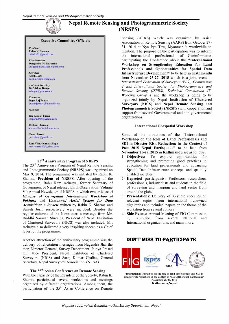
8/17/2019 Nepalese Journal on Geo-informatics Number 14
http://slidepdf.com/reader/full/nepalese-journal-on-geo-informatics-number-14 60/65
Nepal Remote Sensing and Photogrammetric Society
Nepalese Journal on Geoinformatics, Survey Department, Nepal
23rd
Anniversary Program of NRSPSThe 23rd Anniversary Program of Nepal Remote Sensing
and Photogrammetric Society (NRSPS) was organized onMay 9, 2014. The programme was initiated by Rabin K.Sharma, President of NRSPS. After opening of the
programme, Babu Ram Acharya, former Secretary ofGovernment of Nepal released Earth Observation: VolumeVI; Annual Newsletter of NRSPS in which two articles: A
Glimpse of Geo-spatial International Workshop at
Pokhara and Unmanned Aerial System for Data
Acquisition: a Review written by Rabin K. Sharma andSuresh Joshi respectively were included. Besides theregular columns of the Newsletter, a message from Mr.Buddhi Narayan Shrestha, President of Nepal Institutionof Chartered Surveyors (NICS) was also included. Mr.
Acharya also delivered a very inspiring speech as a ChiefGuest of the programme.
Another attraction of the anniversary programme was thedelivery of felicitation messages from Nagendra Jha, thethen Director General, Survey Department, Punya PrasadOli, Vice President, Nepal Institution of CharteredSurveyors (NICS) and Saroj Kumar Chalise, GeneralSecretary, Nepal Surveyor’s Association, (NESA).
The 35th
Asian Conference on Remote Sensing
With the capacity of the President of the Society, Rabin K.Sharma participated several workshops and meetings
organized by different organizations. Among them, the participation of the 35
th Asian Conference on Remote
Sensing (ACRS) which was organized by AsianAssociation on Remote Sensing (AARS) from October 27-31, 2014 at Nya Pye Taw, Myanmar is worthwhile tomention. The purpose of the participation was to inform
the international professionals of Geoinformatics participating the Conference about the “International
Workshop on Strengthening Education for Land
Professionals and Opportunities for Spatial Data
Infrastructure Development” to be held in Kathmandu
from November 25-27, 2015 which is a joint event of International Federation of Surveyors (FIG), Commission
2 and International Society for Photogrammetry and
Remote Sensing (ISPRS), Technical Commission IV,
Working Group 4 and the workshop is going to beorganized jointly by Nepal Institution of Chartered
Surveyors (NICS) and Nepal Remote Sensing and
Photogrammetric Society (NRSPS) with cooperation and
support from several Governmental and non-governmentalorganizations.
International Geospatial Workshop
Some of the attractions of the “International
Workshop on the Role of Land Professionals and
SDI in Disaster Risk Reduction: in the Context of
Post 2015 Nepal Earthquake” to be held from
November 25-27, 2015 in Kathmandu are as follows:1. Objectives: To explore opportunities for
strengthening and promoting good practices ineducation for land professionals and advancing
Spatial Data Infrastructure concepts and spatiallyenabled societies.
2. Expected participants: Professors, researchers, professionals, industrialists and students in the fieldof surveying and mapping and land sector fromaround the globe.
3. Presentations: Delivery of Keynote speeches onrelevant topics from international renowneddignitaries and technical papers on the theme of theworkshop from several authors
4. Side Events: Annual Meeting of FIG Commission7, Exhibition from several National andInternational organizations, and many more.
Don’t miss to p rticip te
“International Workshop on the role of land professionals and SDI in
disaster risk reduction: in the context of 'Post 2015 Nepal Earthquake'
November 25-27, 2015
Kathmandu,Nepal
Nepal Remote Sensing and Photogrammetric Society
(NRSPS)
Executive Committee Officials
President
Rabin K. Sharma
Vice President
Durgendra M. Kayastha
Secretary
Anish [email protected]
Assistant Secretary
Dr. Vishnu Dangol
Treasurer
Jagat Raj Poudel
Members
Raj Kumar [email protected]
Roshani Sharma
Shanti Basnet
Ram Vinay Kumar Singh
NICS
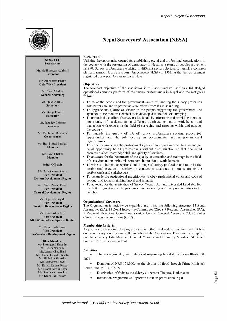
8/17/2019 Nepalese Journal on Geo-informatics Number 14
http://slidepdf.com/reader/full/nepalese-journal-on-geo-informatics-number-14 61/65
Nepal Surveyors' Association
Nepalese Journal on Geoinformatics, Survey Department, Nepal
BackgroundUtilizing the opportunity opened for establishing social and professional organizations inthe country with the restoration of democracy in Nepal as a result of peoples movementin1990, Survey professionals working in different sectors decided to launch a common platform named Nepal Surveyors' Association (NESA) in 1991, as the first governmentregistered Surveyors' Organization in Nepal.
ObjectivesThe foremost objective of the association is to institutionalize itself as a full fledgedoperational common platform of the survey professionals in Nepal and the rest go as
follows
Organizational Structure
The Organization is nationwide expanded and it has the following structure: 14 ZonalAssemblies (ZA), 14 Zonal Executive Committees (ZEC), 5 Regional Assemblies (RA),5 Regional Executive Committees (RAC), Central General Assembly (CGA) and a
Central Executive committee (CEC).
Membership CriteriaAny survey professional obeying professional ethics and code of conduct, with at leastone year survey training can be the member of the Association. There are three types ofmembers namely Life Member, General Member and Honorary Member. At presentthere are 2031 members in total.
Activities
The Surveyors' day was celebrated organizing blood donation on Bhadra 01,
2071
Donation of NRS 151,000.- to the victims of flood through Prime Minister's
Relief Fund in 2071/05/18
Distribution of fruits to the elderly citizens in Tinkune, Kathmandu
Interaction programme at Reporter's Club on professional right
NESA CEC
Secretariate
Mr. Madhusudan AdhikariPresident
Mr. Ambadatta BhattaChief Vice President
Mr. Saroj ChaliseGeneral Secretary
Mr. Prakash DulalSecretary
Mr. Durga PhuyalSecreatry
Mr. Sahadev GhimireTreasurer
Mr. Dadhiram BhattaraiCo-treasurer
Mr. Hari Prasad ParajuliMember
Ms. Jyoti DhakalMember
Other Officials
Mr. Ram Sworup SinhaVice President
Eastern Development Region
Mr. Tanka Prasad Dahal
Vice President
Central Development Region
Mr. Gopinath Dayalu
Vice President
Western Development Region
Mr. Ramkrishna JaisiVice President
Mid-Western Development Region
Mr. Karansingh RawalVice President
Far-Western Development Region
Other Members:
Mr. Premgopal ShresthaMs. Geeta Neupane
Mr. Laxmi ChaudhariMr. Kamal Bahadur Khatri
Mr. Bibhakta ShresthaMr. Sahadev Subedi
Mr. Balam Kumar BasnetMr. Nawal Kishor RayaMr. Santosh Kumar Jha
Mr. Khim Lal Gautam
• To make the people and the government aware of handling the survey professionwith better care and to protect adverse effects from it's mishandling.
• To upgrade the quality of service to the people suggesting the government lineagencies to use modern technical tools developed in the field of surveying.
• To upgrade the quality of survey professionals by informing and providing them theopportunity of participation in different trainings, seminars, workshops andinteraction with experts in the field of surveying and mapping within and outsidethe country
• To upgrade the quality of life of survey professionals seeking proper jobopportunities and the job security in governmental and nongovernmentalorganizations
• To work for protecting the professional rights of surveyors in order to give and getequal opportunity to all professionals without discrimination so that one could promote his/her knowledge skill and quality of services.
• To advocate for the betterment of the quality of education and trainings in the fieldof surveying and mapping via seminars, interactions, workshops etc
• To wipe out the misconceptions and illimage of survey profession and to uplift the
professional prestige in society by conducting awareness programs among the professionals and stakeholders
• To persuade the professional practitioners to obey professional ethics and code ofconduct and to maintain high moral and integrity
• To advocate for the satification of Survey Council Act and Integrated Land Act forthe better regulation of the profession and surveying and mapping activities in thecountry.
Nepal Surveyors' Association (NESA)
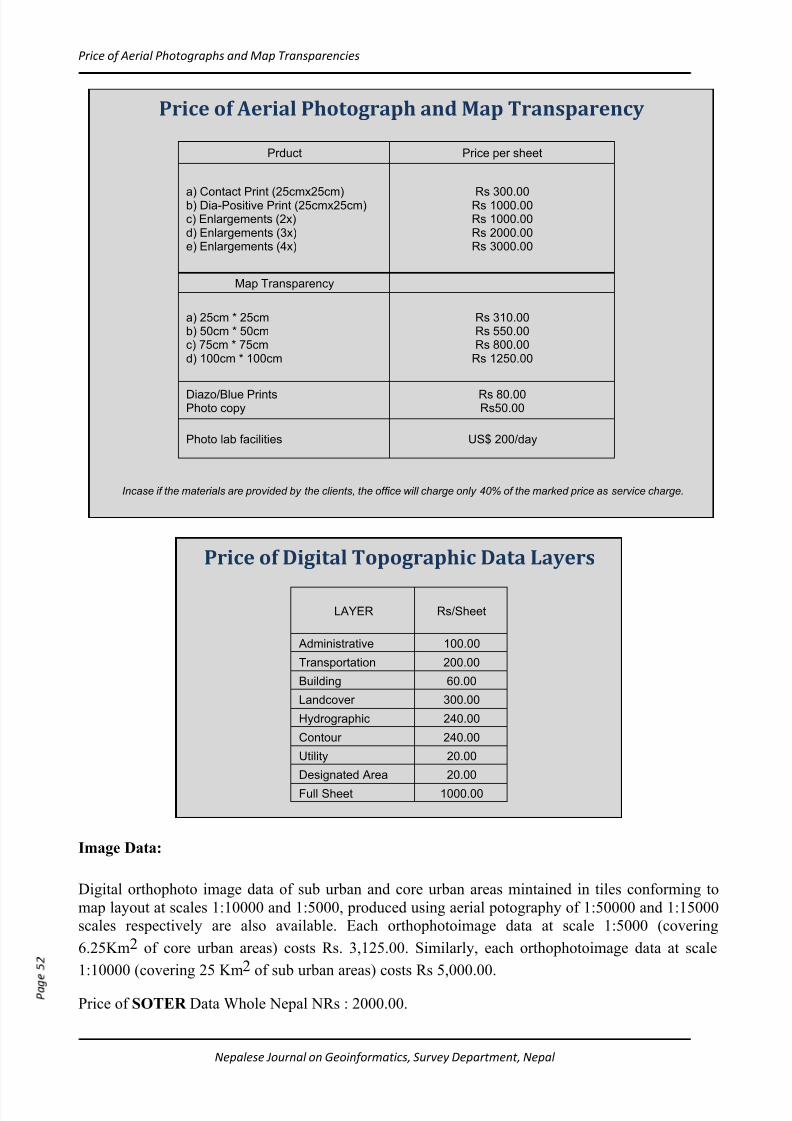
8/17/2019 Nepalese Journal on Geo-informatics Number 14
http://slidepdf.com/reader/full/nepalese-journal-on-geo-informatics-number-14 62/65
Price of Aerial Photographs and Map Transparencies
Nepalese Journal on Geoinformatics, Survey Department, Nepal
Price of Aerial Photograph and Map Transparency
Incase if the materials are provided by the clients, the office will charge only 40% of the marked price as service charge.
Price of Digital Topographic Data Layers
LAYER Rs/Sheet
Administrative 100.00
Transportation 200.00
Building 60.00
Landcover 300.00
Hydrographic 240.00
Contour 240.00
Utility 20.00
Designated Area 20.00
Full Sheet 1000.00
Image Data:
Digital orthophoto image data of sub urban and core urban areas mintained in tiles conforming tomap layout at scales 1:10000 and 1:5000, produced using aerial potography of 1:50000 and 1:15000scales respectively are also available. Each orthophotoimage data at scale 1:5000 (covering
6.25Km2 of core urban areas) costs Rs. 3,125.00. Similarly, each orthophotoimage data at scale
1:10000 (covering 25 Km2 of sub urban areas) costs Rs 5,000.00.
Price of SOTER Data Whole Nepal NRs : 2000.00.
Prduct Price per sheet
a) Contact Print (25cmx25cm)b) Dia-Positive Print (25cmx25cm)c) Enlargements (2x)d) Enlargements (3x)e) Enlargements (4x)
Rs 300.00Rs 1000.00Rs 1000.00Rs 2000.00Rs 3000.00
Map Transparency
a) 25cm * 25cmb) 50cm * 50cmc) 75cm * 75cmd) 100cm * 100cm
Rs 310.00Rs 550.00Rs 800.00
Rs 1250.00
Diazo/Blue PrintsPhoto copy
Rs 80.00Rs50.00
Photo lab facilities US$ 200/day
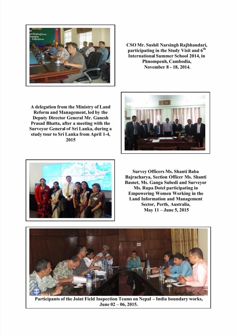
8/17/2019 Nepalese Journal on Geo-informatics Number 14
http://slidepdf.com/reader/full/nepalese-journal-on-geo-informatics-number-14 63/65
Participants of the Joint Field Inspection Teams on Nepal – India boundary works,
June 02 – 06, 2015.
CSO Mr. Sushil Narsingh Rajbhandari,
participating in the Study Visit and 6th
International Summer School 2014, in
Phnompenh, Cambodia,
November 8 - 18, 2014.
A delegation from the Ministry of Land
Reform and Management, led by the
Deputy Director General Mr. GaneshPrasad Bhatta, after a meeting with the
Surveyor General of Sri Lanka, during a
study tour to Sri Lanka from April 1-4,
2015
Survey Officers Ms. Shanti Baba
Bajracharya, Section Officer Ms. ShantiBasnet, Ms. Ganga Subedi and Surveyor
Ms. Rupa Dotel participating in
Empowering Women Working in the
Land Information and Management
Sector, Perth, Australia,
May 11 – June 5, 2015

8/17/2019 Nepalese Journal on Geo-informatics Number 14
http://slidepdf.com/reader/full/nepalese-journal-on-geo-informatics-number-14 64/65
8/17/2019 Nepalese Journal on Geo-informatics Number 14
http://slidepdf.com/reader/full/nepalese-journal-on-geo-informatics-number-14 65/65
Making Sense of Geo-spatial data
for total solution in National and
Local Development Activities
Available Maps and Data
Geodetic Control data
Aerial Photographs
Topographic Base Maps
Terai and middle mountain at the scale of 1:25,000
High hills and Himalayas at the scale of 1:50,000
Land Resources Maps
Administrative and Physiographic Maps of Nepal
Maps of
o
Village Development Committees/Municipalities
o
District, Zone and Development Region
Digital Topographic Data at scales 1:25,000 & 1:50,000
Cadastral Plans
Orthophoto Maps
Orthophoto Digital Data
SOTER Data
VDC Maps (Colour)
Topographic Digital Data at scales 1:100,000 1:250,000 1:500,000 1:1,000,000
Available ServicesEstablishment of control points for various purposes of Surveying and Mapping
Cadastral SurveyingPhoto Laboratory Services
Surveying and mapping for development activities
Topographic and large scale mapping
Digital geo-spatial database support
GIS D l t
Recommended