Understanding EarthGIS Technology Drives a New Relationship Between Humans and the Environment
Jack Dangermond and Matt Artz
Understanding Earth April 2012 2Table of Contents
3 Mapping Redefined4 A Context for Understanding
5 A Framework for Action
6 Our Geospatial Infrastructure
7 A New Approach7 The Geographic Approach
9 Evolving Technology
The Cloud
Crowdsourcing
Neogeography
Collaboration
GIS Is Changing
13 A New Understanding13 What Is Understanding?
14 GIS as a Language
15 GIS for Everyone
17 Seeing the Big Picture18 The Geoscape
Beyond Landscape
19 A New Canvas
Designing a Better World
20 The New Explorers
23 Designing Our Future23 The Geodesign Process
25 Traveling through Time
The Problem of Prediction
Envisioning the Future
27 A New Relationship
An Informed Environment
Technology's Role
The New Natural
29 The Future of Cities
30 The Climate Challenge
31 The Next Generation
32 A New Understanding
33 About the Authors
Table of Contents
Understanding Earth April 2012 3Mapping Redefined
In a word, geography is a science—a thing not of
mere names but of argument and reason, of cause
and effect.
—William Hughes, 1863
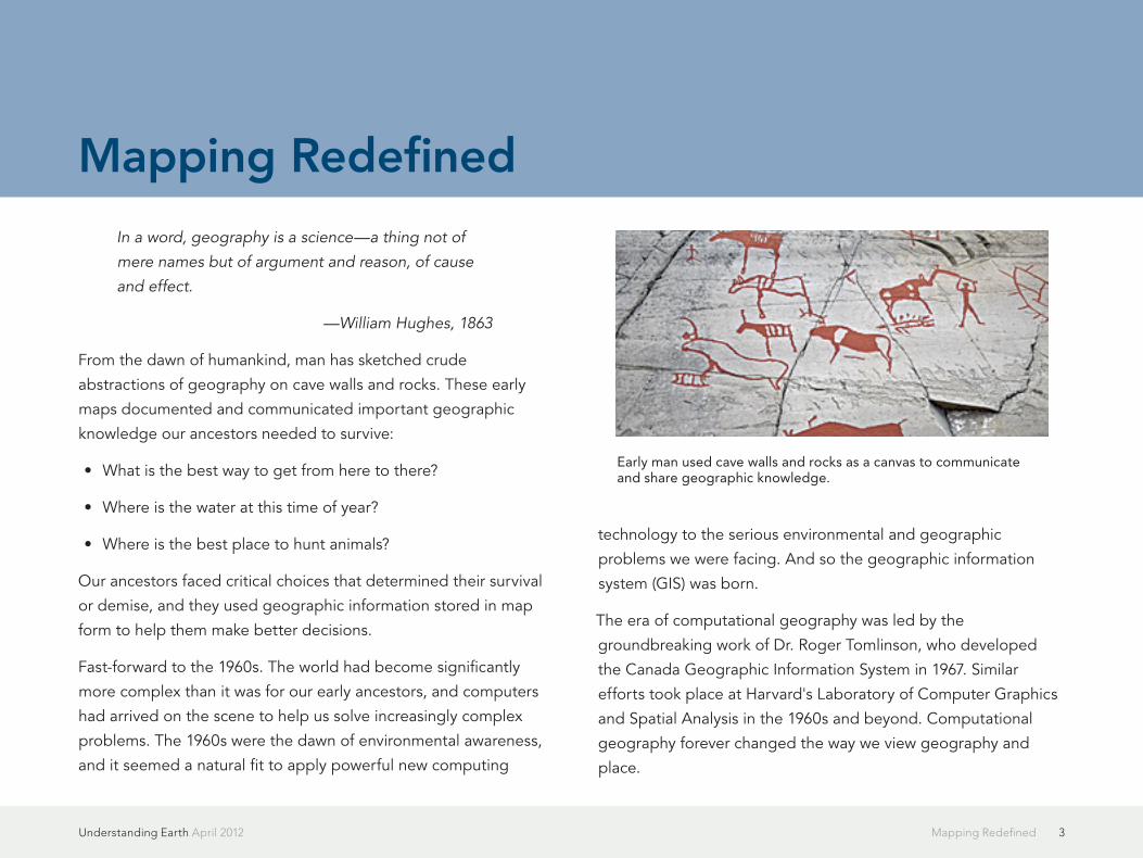
From the dawn of humankind, man has sketched crude
abstractions of geography on cave walls and rocks. These early
maps documented and communicated important geographic
knowledge our ancestors needed to survive:
• What is the best way to get from here to there?
• Where is the water at this time of year?
• Where is the best place to hunt animals?
Our ancestors faced critical choices that determined their survival
or demise, and they used geographic information stored in map
form to help them make better decisions.
Fast-forward to the 1960s. The world had become significantly
more complex than it was for our early ancestors, and computers
had arrived on the scene to help us solve increasingly complex
problems. The 1960s were the dawn of environmental awareness,
and it seemed a natural fit to apply powerful new computing
technology to the serious environmental and geographic
problems we were facing. And so the geographic information
system (GIS) was born.
The era of computational geography was led by the
groundbreaking work of Dr. Roger Tomlinson, who developed
the Canada Geographic Information System in 1967. Similar
efforts took place at Harvard's Laboratory of Computer Graphics
and Spatial Analysis in the 1960s and beyond. Computational
geography forever changed the way we view geography and
place.
Mapping Redefined
Early man used cave walls and rocks as a canvas to communicate and share geographic knowledge.

Understanding Earth April 2012 4Mapping Redefined
Today, GIS has evolved into a crucial tool for science-based
problem solving and decision making. GIS uses the power of
information technology to examine geographic knowledge in
ways that would be extremely time-consuming and expensive
if done manually. The map metaphor remains the dominant
medium for sharing our collective geographic intelligence, and
widespread use of GIS technology is creating a revolution in how
we understand our world and plan for the future.
GIS is the technology of our times and is uniquely
suited to assist in solving the problems that we face.
—Roger Tomlinson
A Context for Understanding
Geographic knowledge is information describing the natural and
human environment on the earth. For our ancestors, geographic
knowledge was crucial for survival. For our own survival today,
geographic knowledge plays an equally important role. The
biggest differences between then and now are that our problems
are much more complex, and the sheer volume of data at our
disposal is daunting. And whereas communicating geographic
knowledge in the past was limited to simple maps, GIS
technology now enables a collective geographic intelligence that
knows no spatial or temporal bounds.
Today we have more geographic data available than ever before.
Satellite imagery is commonplace. Scientists are producing
mountains of modeled data. And an ever-increasing stream of
data from social media, crowdsourcing, and the sensor web is
threatening to overwhelm us. Gathering all this information—this
geographic knowledge—and synthesizing it so that we can more
easily understand it and act on it is the domain of GIS. More data
does not necessarily equate to more understanding, but GIS is
already helping us to make sense of it all, turning this avalanche
Dr. Roger Tomlinson pioneered the development of GIS, ushering in the era of computational geography.
Understanding Earth April 2012 5Mapping Redefined
of raw data into actionable information—a new context for
understanding our world and planning for the future.
Only when people know will they care.
Only when they care will they act.
Only when they act can the world change.
—Dr. Jane Goodall
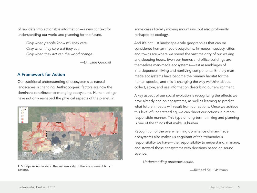
A Framework for Action
Our traditional understanding of ecosystems as natural
landscapes is changing. Anthropogenic factors are now the
dominant contributor to changing ecosystems. Human beings
have not only reshaped the physical aspects of the planet, in
some cases literally moving mountains, but also profoundly
reshaped its ecology.
And it's not just landscape-scale geographies that can be
considered human-made ecosystems. In modern society, cities
and towns are where we spend the vast majority of our waking
and sleeping hours. Even our homes and office buildings are
themselves man-made ecosystems—vast assemblages of
interdependent living and nonliving components. Entirely man-
made ecosystems have become the primary habitat for the
human species, and this is changing the way we think about,
collect, store, and use information describing our environment.
A key aspect of our social evolution is recognizing the effects we
have already had on ecosystems, as well as learning to predict
what future impacts will result from our actions. Once we achieve
this level of understanding, we can direct our actions in a more
responsible manner. This type of long-term thinking and planning
is one of the things that make us human.
Recognition of the overwhelming dominance of man-made
ecosystems also makes us cognizant of the tremendous
responsibility we have—the responsibility to understand, manage,
and steward these ecosystems with decisions based on sound
science.
Understanding precedes action.
—Richard Saul WurmanGIS helps us understand the vulnerability of the environment to our actions.
Understanding Earth April 2012 6Mapping Redefined
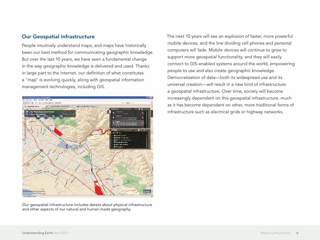
Our Geospatial Infrastructure
People intuitively understand maps, and maps have historically
been our best method for communicating geographic knowledge.
But over the last 10 years, we have seen a fundamental change
in the way geographic knowledge is delivered and used. Thanks
in large part to the Internet, our definition of what constitutes
a "map" is evolving quickly, along with geospatial information
management technologies, including GIS.
The next 10 years will see an explosion of faster, more powerful
mobile devices, and the line dividing cell phones and personal
computers will fade. Mobile devices will continue to grow to
support more geospatial functionality, and they will easily
connect to GIS-enabled systems around the world, empowering
people to use and also create geographic knowledge.
Democratization of data—both its widespread use and its
universal creation—will result in a new kind of infrastructure:
a geospatial infrastructure. Over time, society will become
increasingly dependent on this geospatial infrastructure, much
as it has become dependent on other, more traditional forms of
infrastructure such as electrical grids or highway networks.
Our geospatial infrastructure includes details about physical infrastructure and other aspects of our natural and human-made geography.
Understanding Earth April 2012 7A New Approach
A transformation is taking place. Businesses and governments,
schools and hospitals, nonprofit organizations, and private
citizens are taking advantage of it. All around the world, people
are working more efficiently because of it. Information that was
limited to spreadsheets and databases is being unleashed in a
new, exciting way—through the use of geography.
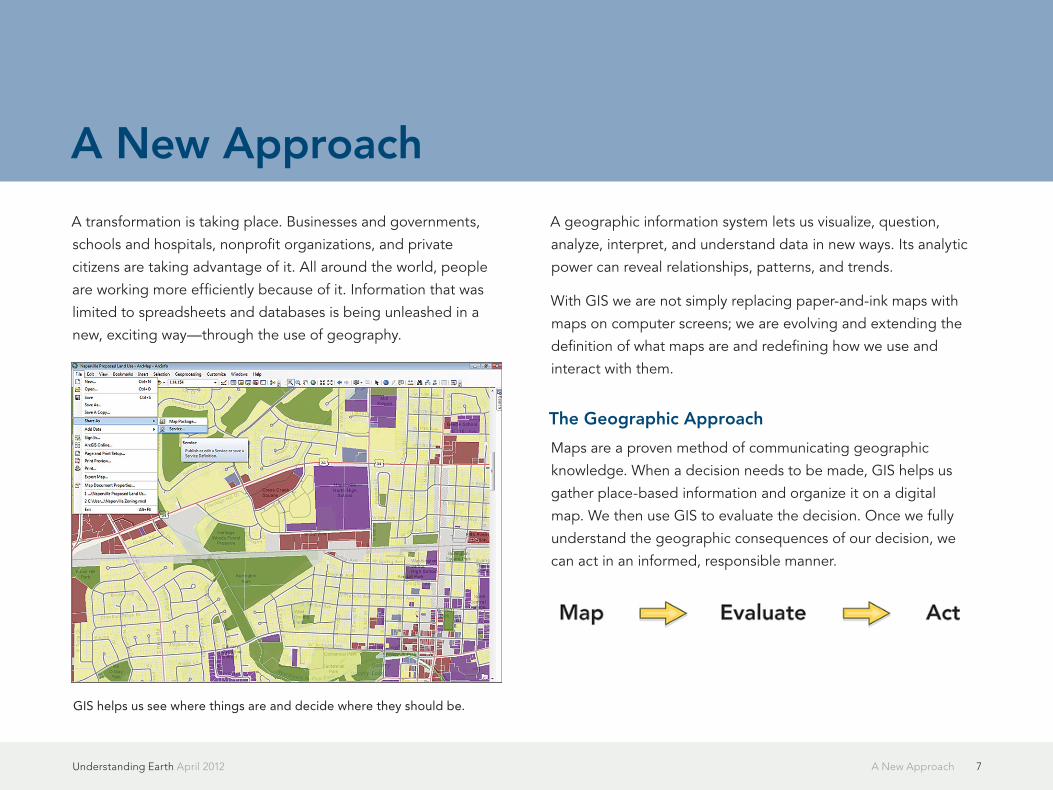
A geographic information system lets us visualize, question,
analyze, interpret, and understand data in new ways. Its analytic
power can reveal relationships, patterns, and trends.
With GIS we are not simply replacing paper-and-ink maps with
maps on computer screens; we are evolving and extending the
definition of what maps are and redefining how we use and
interact with them.
The Geographic Approach
Maps are a proven method of communicating geographic
knowledge. When a decision needs to be made, GIS helps us
gather place-based information and organize it on a digital
map. We then use GIS to evaluate the decision. Once we fully
understand the geographic consequences of our decision, we
can act in an informed, responsible manner.
A New Approach
GIS helps us see where things are and decide where they should be.

Understanding Earth April 2012 8A New Approach
This geographic approach to problem solving helps us answer a
wide variety of important questions related to geography, such
as these:
• Where are my customers and potential customers?
• Which areas of my town are most vulnerable to natural
disasters?
• Where should we locate a new elementary school?
GIS helps answer such questions by combining data from
governments and other sources in a personalized map.
GIS benefits organizations of all sizes and in almost every industry,
and there is a growing interest in and awareness of its economic
and strategic value. The benefits of GIS generally fall into five
basic categories:
• Cost savings resulting from greater efficiency
• Better decision making
• Improved communication
• Better geographic information record keeping
• Managing geographically
By comparing historical disaster data with vulnerable populations, GIS reveals patterns useful for disaster planning.
GIS can produce "heat maps" to visually represent information using colors.

Understanding Earth April 2012 9A New Approach
Remote-sensing satellites and earthbound sensors are providing
us with vast amounts of data about our planet. With the
availability of new, easy-to-use GIS tools for displaying and
analyzing this data, now everyone can be an explorer. The
benefits to both society and the environment are far reaching and
usher in a new era of understanding for our world.
From desktop computers to smartphones to the cloud, it is
becoming easier for anyone to use and benefit from GIS.
Evolving Technology
The geospatial industry, the IT environment, and the world
around us are all changing rapidly. We often talk about how GIS
is changing the world, but at the same time, it's important to
understand how the world is changing GIS.
GIS has a long history of successfully adapting to new
technologies, applications, customer types, and business models.
From mainframes to minicomputers, UNIX workstations to PCs,
desktop to enterprise deployment, each round of technological
innovation has led to improvements for GIS. Today, GIS continues
to evolve in response to changes in information technology.
The distributed computing environment enabled by the web
introduces a whole new set of challenges and opportunities.
Merging with and adapting to the latest advances is making GIS
easier to use, more collaborative, more powerful, and ultimately
more useful for the work you do every day.
The Cloud
Cloud computing delivers technological capabilities on demand
as a service via the Internet. Unlike the classic computing model
of operating system plus software applications with files and
database storage, the cloud model consists of services, clients,
hosted content, and virtual machines. In other words, you do
not load and run software and store data on your computer; you
log in and use the system in the cloud. In addition to allowing
computing on the public Internet, the cloud can be implemented
within a smaller, more secure community (creating a so-called
private cloud) using the same concepts.
"The cloud" supports both enterprise and web deployments, transforming GIS access, usability, and collaboration.
Understanding Earth April 2012 10A New Approach
Cloud computing is emerging as an important technology trend
in almost every industry, including the GIS community, and it is
rapidly moving into the mainstream. For many people, this is a
more efficient solution for maintaining an information technology
infrastructure. It also provides a solution for many government
agencies, because it allows them to serve their data without the
cost of administering hardware.
Crowdsourcing
Sometimes referred to as volunteered geographic information
(VGI) or user-generated content (UGC), crowdsourced data is
data contributed by nonauthoritative sources (e.g., everyday
citizens). Long the keepers of purely authoritative data, GIS
practitioners are beginning to take crowdsourced data seriously.
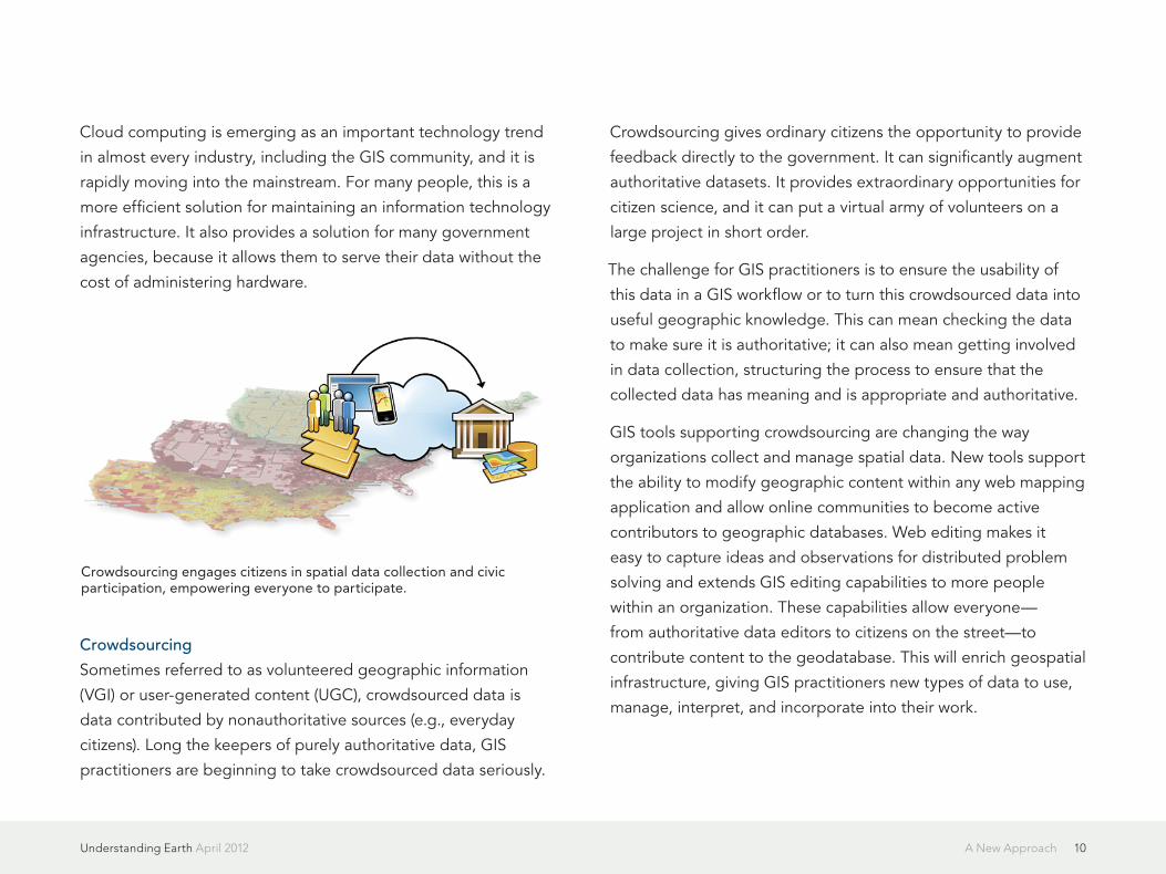
Crowdsourcing gives ordinary citizens the opportunity to provide
feedback directly to the government. It can significantly augment
authoritative datasets. It provides extraordinary opportunities for
citizen science, and it can put a virtual army of volunteers on a
large project in short order.
The challenge for GIS practitioners is to ensure the usability of
this data in a GIS workflow or to turn this crowdsourced data into
useful geographic knowledge. This can mean checking the data
to make sure it is authoritative; it can also mean getting involved
in data collection, structuring the process to ensure that the
collected data has meaning and is appropriate and authoritative.
GIS tools supporting crowdsourcing are changing the way
organizations collect and manage spatial data. New tools support
the ability to modify geographic content within any web mapping
application and allow online communities to become active
contributors to geographic databases. Web editing makes it
easy to capture ideas and observations for distributed problem
solving and extends GIS editing capabilities to more people
within an organization. These capabilities allow everyone—
from authoritative data editors to citizens on the street—to
contribute content to the geodatabase. This will enrich geospatial
infrastructure, giving GIS practitioners new types of data to use,
manage, interpret, and incorporate into their work.
Crowdsourcing engages citizens in spatial data collection and civic participation, empowering everyone to participate.

Understanding Earth April 2012 11A New Approach
Neogeography
The neogeography movement—emphasizing ease of use,
visualization, mashups, and so on—has been very successful
at changing the way society uses and interacts with computer-
based maps and geographic knowledge. Purveyors such as
Google and Microsoft have made great advances in basic
mapping, visualization, and mashups, and in the process have
shown us new user interface patterns. GIS technology is learning
from these new patterns and incorporating them in the next
generation of software. As a result, the distinction between
the world of neogeography and the GIS world is gradually
disappearing, and GIS technology is becoming much more
straightforward. This simplification comes from a new focus on
how everyday people use the information and capabilities of GIS,
resulting in a simple yet powerful system for working with maps
and geographic knowledge. These changes are greatly increasing
usability of the technology by GIS practitioners as well as society
in general.
Collaboration
New collaboration technologies are redefining how we work
together and share geographic information at every scale. This
collaboration crosses traditional lines such as organizational
boundaries, professional domains, and geographic borders.
Sharing gives people access to vast stores of geographic
knowledge that was previously difficult or impossible to obtain
and leads to more informed decision making.
With new GIS collaboration tools, people can share and discover
maps and apps and mash them up through virtually any device.
The map is still the focus, but this map is different: behind this
map sits the data model; the symbology of the map; and, in
some cases, analytics. So when you share a map, you're not
simply sharing a picture; you're sharing a collection of geographic
knowledge. GIS professionals are already using this capability to
create knowledge, maps, and models and easily publish them on
the web for anybody to access
No one organization can create the GeoWeb or own the entire
global spatial data infrastructure. These are being constructed
by thousands of individuals and organizations all over the world
With GIS in the cloud, anyone can share maps, data, and applications.
Understanding Earth April 2012 12A New Approach
using new collaboration tools to create geoservices and build
applications on top of this infrastructure.
GIS Is Changing
GIS has proved to be a flexible, adaptive technology, evolving
as the information technology ecosystem around it changes. At
each step in this evolution, GIS has not just adapted to these
changes but embraced them, becoming more powerful and more
valuable. Recent technological advances are helping us reenvision
what a GIS is in a new context. As a web-hosted or cloud-based
system with ready-to-use maps and apps, GIS is rapidly moving
toward the vision of use anywhere, anytime, by anyone.
How we use GIS, the way we interact with it, and the way it
interacts with the world are all changing. While some of this
change has been and will be driven by new tools and technology,
the biggest driver of change is you, the GIS user. Esri is not
redefining GIS; you are. You're identifying the technologies that
need to be embraced and the new functionality that needs to be
added; and perhaps most significant, you are showing how GIS
can be applied in new and exciting ways for the betterment of
humankind and the environment.
Understanding Earth April 2012 13A New Understanding
Stories play an important role in society, and storytelling is one of
the things that make us uniquely human. Stories convey important
knowledge about the world around us, often in a simplified yet
dramatic fashion designed for maximum impact. We have much
to learn, remember, and understand in life, but wrap a great story
around something, and it will make an impression on us that lasts
a lifetime.
Maps are wonderful organizers of information, and they are an
ideal stage on which to tell stories. But the stories that maps tell
are not designed strictly for entertainment. Stories told with maps
are designed to educate, inform, and inspire people. They are a
platform for understanding and action.
What Is Understanding?
Our world is changing rapidly, and we're increasingly aware of
the role humans are playing in that change. Climate change,
urbanization, security, poverty, inequality—these are difficult
problems that we must deal with, and they're affecting us
as individuals as well as impacting our organizations and
governments. For us to really address these things, we can't just
keep doing the same things that got us here. We need a different
approach. We need collective intelligence, and our actions need
to be based on this intelligence. An informed, science-based
approach is our best hope for confronting these unprecedented
challenges. And the people who use GIS technology are playing
A New Understanding
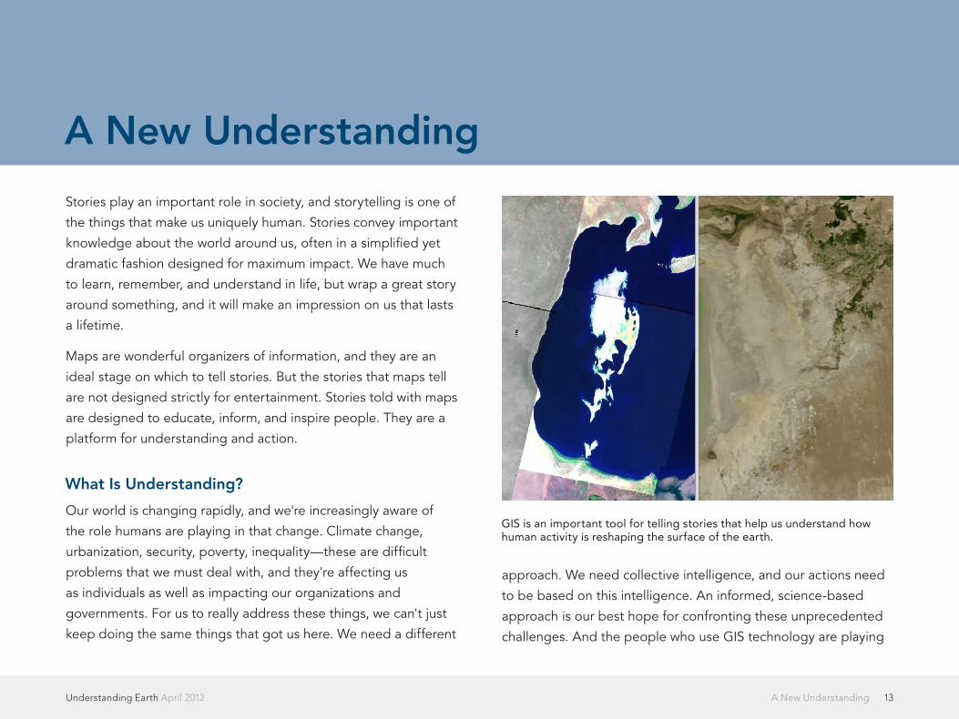
GIS is an important tool for telling stories that help us understand how human activity is reshaping the surface of the earth.
Understanding Earth April 2012 14A New Understanding
an increasingly important role in helping to create this new
understanding of our world.
Understanding is about knowing. It's quite human and is built on
real experiences, reasoning, and deep thinking. Knowing enables
us to understand, think, predict, explain, add meaning, and
gain insight. Our minds are the framework within which all this
happens. They organize and synthesize information for us, then
integrate it into our lives. This is understanding.
GIS as a Language
Geography has always been a critical type of information that
humans—in fact, all animals—collect, organize, and use. Place-
based information is vital to survival on our planet. As our world
has become more complex, and our ability to understand has
also grown, GIS technology has evolved to help us process
information about place and put it in a context that allows us to
act. GIS is actually extending our minds by abstracting our world
into pieces of knowledge that we create and maintain—data,
imagery, models, maps, and apps. GIS is facilitating a systematic
framework for knowing, and our shared work is leading to
collective understanding.
This is not just theoretical. From the beginning, GIS has been a
very practical technology. When Tomlinson and his colleagues
first began to implement these ideas in the 1960s, the problem
was to harness the power of information technology to gain an
understanding of geography that the human mind could not
deduce without the assistance of computers.
Today, GIS integrates and synthesizes information from many
sources and does it in volumes we could not have imagined
30 years ago. The availability of new technologies and the
growing concern for our planet mean that we are producing
an ever-increasing store of data describing our earth. We're
being bombarded with data from a combination of old and new
sources—satellites, sensors, crowdsourcing ("human sensors"),
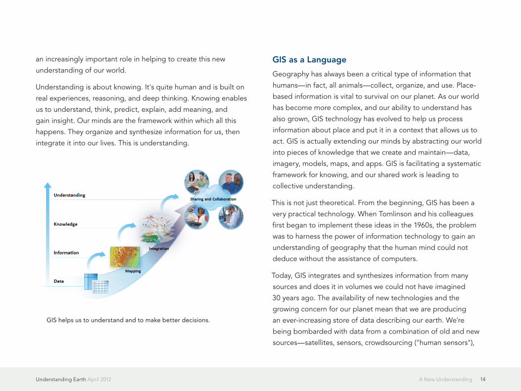
GIS helps us to understand and to make better decisions.

Understanding Earth April 2012 15A New Understanding
models, digitized historic records, and much more. Only when
these billions of bits of information are combined and organized
can we achieve a higher meaning—a true understanding of
our world. And arriving at this understanding will require the
right technology and culture for sharing our data and building a
common geospatial infrastructure.
As a kind of language, GIS also facilitates communication and
collaboration, breaking down barriers between individuals,
organizations, institutions, and the world. This is part of its power.
With the number and severity of the problems facing our modern
world, many of them having to do with place, GIS is becoming an
essential new language for understanding.
Our species needs, and deserves, a citizenry with
minds wide awake and a basic understanding of how
the world works.
—Carl Sagan
GIS for Everyone
A new pattern for GIS has emerged, making GIS available to
everyone. A long progression of efforts is bringing our work—
substantial, authoritative source information—to the web and
blending it with social network and crowdsourced information.
This new pattern is making all of this work available through
lightweight viewers and mobile devices, providing a broad
context of understanding to individuals, organizations, and
governments—to everyone.
But will this new pattern be broadly adopted? Is it just of interest
to GIS professionals, or will it be adopted by a wider audience?
In fact, because the benefits are so great, this new pattern
of GIS for everyone is already being broadly adopted. It
is connecting GIS professionals with knowledge workers,
managers, policy makers, and citizens, extending the reach of
geographic knowledge to everyone. It is empowering citizens
GIS extends our minds, abstracting our world and providing a systematic framework for understanding.
Understanding Earth April 2012 16A New Understanding
to participate in the same network environment, using the same
infrastructure and sharing common services, to create a collective
understanding.
GIS professionals continually amaze us with the creativity
they display in applying the technology in solving complex
problems and supporting critical decisions. From sea-level rise
to deforestation; from disaster recovery to disease monitoring;
from vehicle routing to demographic analysis, it's clear that GIS
is already being widely used as a tool to help us understand and
act.

Understanding Earth April 2012 17Seeing the Big Picture
Geography has at least one thing in common with other
disciplines: it has become fragmented. As our world has become
more complex, science has responded by becoming narrowly
focused. Thousands of very smart people are making remarkable
discoveries in their own disciplines. But who is looking at the "big
picture"?
It's only logical. When life gets complicated, we often tend
to focus on the little things. It's a coping mechanism. It helps
us deal with being overwhelmed; it helps us feel as if we are
accomplishing something.
At some point we need to take a step back and realize that we
can't understand an entire forest if we're addressing issues one
tree at a time.
We've done an admirable job of examining and understanding a
multitude of component pieces that make our planet work. Now
our grand challenge is to integrate all this knowledge so we can
understand the big picture.
But how do we put all the pieces back together again so that
we can understand the whole? How do we defragment our
geographic knowledge?
Jerry Dobson, professor of geography at the University of Kansas,
suggests that we already have the ideal tool for the job: the
macroscope.
Citing the work of Joël de Rosnay, an early proponent of systems
thinking, Dobson argues that the future of geography is "the
macroscope"—a framework for assembling large amounts of
environmental and human knowledge so that we can get a truly
geographic understanding of our world.
We have in our hands a new scientific instrument as
powerful as any that have come before it, including
the microscope and the telescope. Collectively,
GIS, GPS, satellite remote sensing, and popular
geographics constitute a macroscope that allows
scientists, practitioners, and the public alike to view
the earth as never before.
GIS technology is the unifying force that can bring together
fragmented data and disciplines into a common framework.
Collating and combining all the little discoveries is the next
scientific frontier. It's where the next big discoveries will be
made—by enticing people to view old questions in new ways—
and dramatic new insights are likely to result from this.
Seeing the Big Picture

Understanding Earth April 2012 18Seeing the Big Picture
"This geographically enabled macroscope . . . allows humans to
visualize earth processes extending over vast regions or even the
whole globe while still maintaining the finest measurable detail,"
says Dobson.
Clearly, there is much left to discover, and our
community is in an ideal position to advance the
macroscope and support or lead the coming
revolution in science theory, continues Dobson.
The macroscope is here today, and science is already
changing in response to it. We are entering a new
scientific era that may be every bit as exciting and
enlightening as the revolutions prompted earlier
by the microscope and telescope. Surely our
professional lives will be richer, and science itself will
gain, if we, who know the marvelous instrument best,
insist on using it ourselves to tackle the greatest
mysteries of our time.
The Geoscape
The world around us is a complex place, and one way we manage
that complexity is through a process of abstraction. In its purest
sense, abstraction is about the reduction of detail down to the
bare essentials we still need in order to understand.
Maps are a fascinating example of abstraction. Maps are
abstractions of landscapes and geography, and they have
proved to be a particularly useful aspect of human technology
throughout our history. Until relatively recently, maps were
predominantly two-dimensional: paper maps with complex
geography abstracted onto a flat surface. New methods of
presentation were created in an attempt to relay complex terrain
and other information that moved beyond the two dimensions,
but these methods, while useful, often fell short of conveying the
true nature of complex geographic space.
Enter computers. The move from paper-based abstractions
toward computer-based abstractions of geographic space has
given us a powerful new context for understanding—and not just
for two-dimensional landscapes, but for geography spanning the
Understanding Earth April 2012 19Seeing the Big Picture
third and fourth dimensions as well. Bill Miller likes to call this new
canvas "the geoscape."
Beyond Landscape
Miller, head of the GeoDesign Services group at Esri, has a vision
for the integration of geospatial technologies with the design
process—a vision long shared by a group of people that includes
University of California, Santa Barbara's Michael Goodchild,
Harvard University's Carl Steinitz, and a handful of others. Miller
took the first step toward making this vision a reality when he
assembled a small team to develop a tool that allowed users to
quickly sketch features in a GIS environment—the first small step
toward what is now commonly referred to as "geodesign."
While identifying the technology hurdles the GIS industry
needed to overcome to fully realize the promise of geodesign,
Miller noted a fundamental contextual obstacle: our traditional
approach to abstracting the landscape severely limited our
ability to move forward with geodesign. We couldn't fully realize
the vision of geodesign without a framework for a more holistic,
comprehensive understanding of the world around us.
A New Canvas
Different levels of understanding often require different levels
of abstraction, and it's clear that's what was happening with
geodesign. As TED founder Richard Saul Wurman has so
succinctly stated, "Understanding precedes action." Design
is action, and before we can design, we must understand.
Geodesign—the act of thoughtfully creating the future for the
mutual benefit of humans and the natural environment—requires
a heightened level of understanding.
Understanding the world for the purpose of geodesign
necessitated extending our view of geographic space. "This
meant moving from 2D to 3D and to 4D, coupled with the idea
that most data, at some level, is spatial and that all types of
spatial data (physical, biological, social, cultural, economic, urban,
etc.) can be georeferenced," states Miller. "This ultimately led to
an expanded view of what is typically envisioned, or imagined,
when referring to the geo portion of geodesign."
Extending our traditional methods of abstracting the landscape
to include 3D "provides us with the ability to georeference what
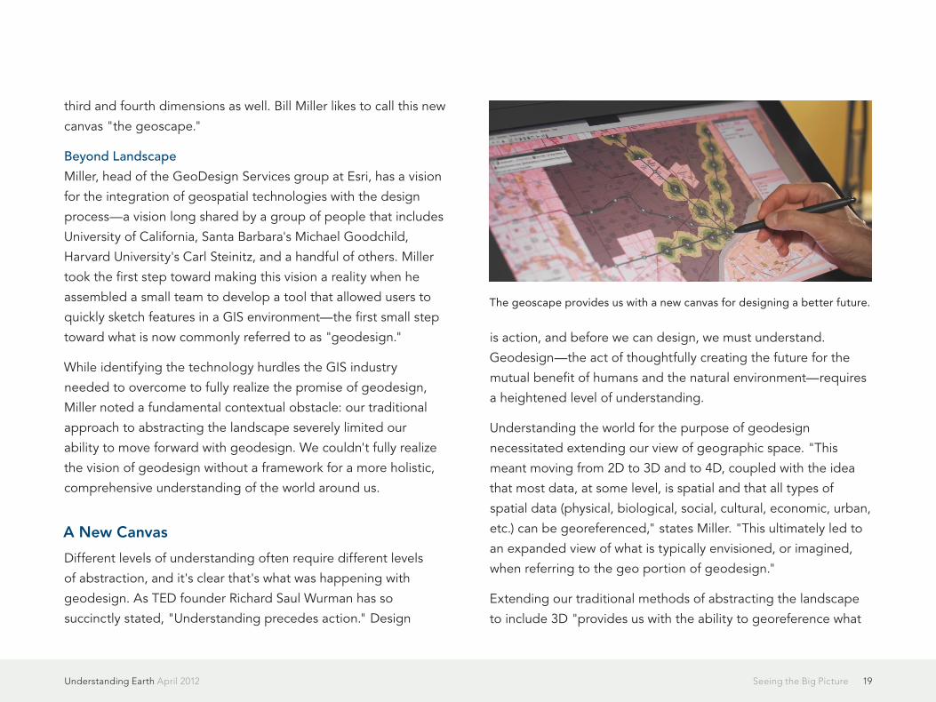
The geoscape provides us with a new canvas for designing a better future.
Understanding Earth April 2012 20Seeing the Big Picture
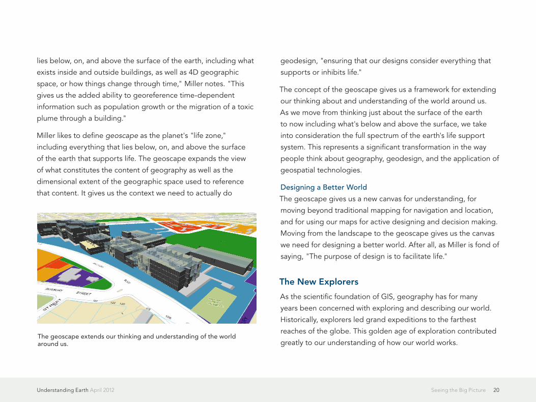
lies below, on, and above the surface of the earth, including what
exists inside and outside buildings, as well as 4D geographic
space, or how things change through time," Miller notes. "This
gives us the added ability to georeference time-dependent
information such as population growth or the migration of a toxic
plume through a building."
Miller likes to define geoscape as the planet's "life zone,"
including everything that lies below, on, and above the surface
of the earth that supports life. The geoscape expands the view
of what constitutes the content of geography as well as the
dimensional extent of the geographic space used to reference
that content. It gives us the context we need to actually do
geodesign, "ensuring that our designs consider everything that
supports or inhibits life."
The concept of the geoscape gives us a framework for extending
our thinking about and understanding of the world around us.
As we move from thinking just about the surface of the earth
to now including what's below and above the surface, we take
into consideration the full spectrum of the earth's life support
system. This represents a significant transformation in the way
people think about geography, geodesign, and the application of
geospatial technologies.
Designing a Better World
The geoscape gives us a new canvas for understanding, for
moving beyond traditional mapping for navigation and location,
and for using our maps for active designing and decision making.
Moving from the landscape to the geoscape gives us the canvas
we need for designing a better world. After all, as Miller is fond of
saying, "The purpose of design is to facilitate life."
The New Explorers
As the scientific foundation of GIS, geography has for many
years been concerned with exploring and describing our world.
Historically, explorers led grand expeditions to the farthest
reaches of the globe. This golden age of exploration contributed
greatly to our understanding of how our world works. The geoscape extends our thinking and understanding of the world around us.
Understanding Earth April 2012 21Seeing the Big Picture
This was followed by the space age—an era where we completely
left the planet and turned our cameras and sensors to look back
on our home, giving us an entirely new perspective of ourselves,
our planet, and the opportunities for exploration that await us.
No longer bound to the surface of the earth as our species had
been for untold millennia, the view from a few hundred miles up
in space gave mankind its first glimpse of our planetary system as
a whole.
While data remotely sensed from satellites continues to play
an important role in monitoring and understanding our planet,
"earth observation" has more recently taken on a whole new
dimension, thanks to the deployment of an increasingly more
complex and pervasive network of earthbound sensors. These
sensors are practically everywhere you look—and in places you
could never imagine. From stream gauges to seismographs, from
weather stations to air quality monitors, from ocean buoys to
even ourselves, countless sensors are measuring and collecting
important data about our planet at a rate that was inconceivable
just a short time ago.
Modern science and advanced technology have resulted in
unprecedented access to global environmental information
through the placement of countless sensors across the planet—
and the linking together of this information through the Internet.
We're collecting more information about the geography of planet
Earth today than ever before. New data sources, along with
the sheer volume of data being collected, are spawning a new
age of exploration. But the new explorers are navigating a vast,
uncharted sea of data. What do we do with all of this sensed
data? How can we make sense of the sensor web?
This new sensor web has inundated us with data that needs
to be stored, managed, analyzed, and used to inform better
decisions about our many environmental challenges. Integrating
and synthesizing all this disparate sensor data into a single,
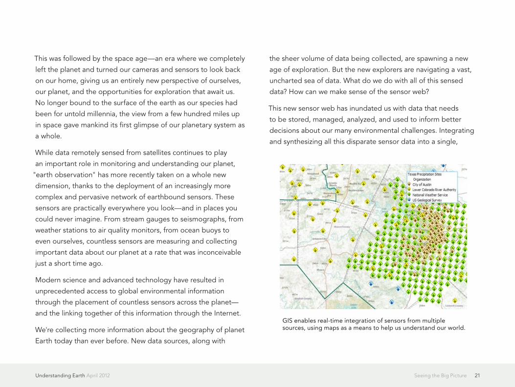
GIS enables real-time integration of sensors from multiple sources, using maps as a means to help us understand our world.
Understanding Earth April 2012 22Seeing the Big Picture
comprehensive view—a global dashboard—is our next great
opportunity for exploring our world.
A global dashboard is a decision support tool that helps monitor
current conditions, identify change, and drive informed action.
It enables exploration at scales from local to global. It allows
people to visualize large, complex spatial datasets in the context
of their neighborhoods, their streets, and their houses. The ability
to explore a world of data from a personal perspective is a very
powerful idea.
Thanks to the rich information flow provided by our new world
of sensors and the availability of new mapping tools to display
and analyze this information in context, now everyone can
be an explorer. This has far-reaching benefits to both society
and the environment, ushering in a new era of science-based
understanding and leading us toward more informed, equitable,
and sustainable action.
The world, indeed the whole universe, is a beautiful,
astonishing, wondrous place. There is always more to
find out.
—Derek K. Miller
Understanding Earth April 2012 23Designing Our Future
Design is always and necessarily an art as well as a
problem-solving activity.
—David Pye, The Nature of Design
The key to developing a true understanding of our complex and
dynamic earth is creating a framework that allows us to take many
different pieces of past and future data from a variety of sources
and merge them in a single system. GIS is a sophisticated
technology already in widespread use by planners, engineers,
and scientists to display and analyze all forms of location-
referenced data about the health, status, and history of our
planet.
GIS enables a geodesign framework for analyzing and managing
anthropogenic earth issues by allowing us to inventory and
display large, complex spatial datasets. We can also analyze the
potential interplay between various factors, getting us closer to
a true understanding of how our dynamic earth systems may
change in the coming decades and centuries.
Geodesign borrows concepts from landscape architecture,
environmental studies, geography, planning, regenerative
studies, and integrative studies. Much like GIS and environmental
planning before it, geodesign takes an interdisciplinary,
synergistic approach to solving critical problems and optimizing
location, orientation, and features of projects both local and
global in scale.
Design is art within the framework of limitations—limitations
that arise as a result of function, world view, bias, and other
factors, but also limitations that arise as a result of place. Design
considering place was at the core of Ian McHarg's beliefs, and it
is the basis for research and development efforts in the emerging
field of geodesign.
To a certain extent, this is already done today by numerous
GIS practitioners in fields like urban and regional planning and
environmental management. But geodesign makes this easier by
making it an integral part of the workflow, both shortening the
cycle time of the design process and improving the quality of the
results.
The Geodesign Process
When an idea is proposed with geographic consequences—a
housing development, a shopping center, a road, a wildlife
preserve, a farm—it first goes through a design process. After
Designing Our Future

Understanding Earth April 2012 24Designing Our Future
it is initially designed, a project is vetted against geographic
constraints.
A typical project will go through many iterations of design and
evaluation. As the constraints of geography on the project—and
the impacts of the project on geography—are revealed, the
design is continually refined. Because design and evaluation have
traditionally been separate disciplines, this phase of a project can
be time-consuming, inefficient, and tedious.
What if we could reduce the time and tedium of these iterations
by integrating design directly into the GIS workflow?
This integration—which we refer to as the geodesign workflow—
is a promising alternative to traditional processes. It allows
designers and evaluators to work closely together to significantly
lessen the time it takes to produce and evaluate design iterations.
Cycle time is shortened because geodesign moves analysis to
an earlier stage in the design process. Rather than analyzing
the potential effects of a proposed project after the design
phase, critical factors are instead taken into consideration up
front. The quality of the results improves because the project
is designed around, in concert with, and/or to fully leverage
certain geographic, environmental, and social features while
simultaneously minimizing undesirable impacts to those same
features.
Combining the wealth of available data about our world with
sophisticated analysis and management tools is the prescription
Interactive geodesign tools let us design the future while considering geographic constraints.
Understanding Earth April 2012 25Designing Our Future
for understanding and shaping the future of our planet—an
anthropogenic future where advances in human society,
technology, and so on, are designed in close collaboration with
nature, resulting in the best of the possible future worlds. And
this is what "designing our future" means. It's a huge task and a
delicate balance, for sure, but with help from GIS and geodesign
tools, we readily accept that challenge. Because, frankly, we have
no other choice.
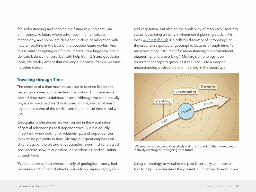
Traveling through Time
The concept of a time machine as used in science fiction has
certainly captured our collective imagination. But the science
behind time travel is dubious at best. Although we can't actually
physically move backward or forward in time, we can at least
experience some of the thrills—and benefits—of time travel with
GIS.
Geospatial professionals are well versed in the visualization
of spatial relationships and dependencies. But it is equally
important, when looking for relationships and dependencies,
to examine proximity in time. McHarg put great emphasis on
chronology, or the placing of geographic layers in chronological
sequence to show relationships, dependencies, and causation
through time.
"We found the earliest events, mainly of geological history, had
pervasive and influential effects, not only on physiography, soils,
and vegetation, but also on the availability of resources," McHarg
states, describing an early environmental planning study in his
book A Quest for Life. He calls his discovery of chronology, or
the order or sequence of geographic features through time, "a
most revelatory instrument for understanding the environment,
diagnosing, and prescribing." McHarg's chronology is an
important concept to grasp, as it can lead us to a deeper
understanding of structure and meaning in the landscape.
Using chronology to visualize the past is certainly an important
tool to help us understand the present. But can we do even more
We need to move beyond passively trying to "predict" the future toward actively creating or "designing" the future.
Understanding Earth April 2012 26Designing Our Future
with this geographic knowledge? Can we use it to predict the
future?
The Problem of Prediction
Predicting the future is an elusive exercise. Just pick up an old
magazine from the 1960s that talks about what life will be like in
the year 2000, or watch a movie or read a book set 50 years out.
While highly entertaining, nobody ever gets it right. Very few get
even remotely close.
The real problem of predicting the future is one of complexity.
"There really is only one past," notes Stephen Ervin of Harvard
University's Graduate School of Design, "but there are multiple
futures." So if predicting the future is so difficult, impractical, or
downright impossible, should we even bother trying? Is there
anything to gain from such folly?
Perhaps we need to move beyond prediction and find a different
way to think about our relationship with the future. "The future
can't be predicted," says environmental scientist and systems
thinker Donella Meadows, "but it can be envisioned and brought
lovingly into being."
Envisioning the Future
As McHarg states in his book To Heal the Earth, "Processes, laws,
and time reveal the present." Meadows echoes this idea, noting,
"We experience now the consequences of actions set in motion
yesterday and decades ago and centuries ago." Projecting this
same concept of chronology forward in time, we can study the
past to both understand the present and envision the future. As
someone said at the 2012 GeoDesign Summit, "By designing
geography, you're designing history." We need to embrace this
idea.
"In a very real way, designers create the human environment,"
says William McDonough in Twenty-First Century Design. "They
make the things we use, the places we live and work, our modes
of communication and mobility." From a building to a highway,
from a city to a utility network, geographic design decisions we
make today can have huge consequences for the lives of future
generations.
We have the geospatial tools and techniques in place to
understand how the past has created the present, and through
the thoughtful and careful application of these same tools and
techniques, we can more actively design the future. Trying to
shape our current actions to ensure the best possible future is
a delicate balancing act, and there are many complex factors
to consider. But achieving that balance offers hope for a future
ideally suited to both humans and the environment.
Instead of asking what the world might look like in the future, we
should begin asking ourselves: What do we want the world to
look like? And how can we make it happen?
Understanding Earth April 2012 27Designing Our Future
A New Relationship
Our use of and reliance on technology has moved us toward a
new relationship with the environment. In countless ways, both
seen and unseen, the ecosystems we once saw as "natural"
have become strange hybrids—part natural, part man-made,
struggling for balance under the watchful eye of human
management.
As we move forward in this more mutually beneficial relationship
with the environment, the dynamic is evolving—from using
technology to merely exploit our surroundings toward the
thoughtful application of technology to actively manage, design,
and sustain our surroundings. This new relationship with the
environment features a much tighter integration between humans
and technology, where all decisions are carefully designed to
maximize the benefit—and minimize the harm—to both humans
and natural systems.
An Informed Environment
When man began to understand the overwhelming effects of
mass exploitation on natural earth systems, he reacted with
conservation. This era began with the preservation of significant,
dramatic, and unique examples of ecosystems, perhaps best
exemplified by national parks such as Yellowstone and Yosemite.
This trend continued with the preservation of remnant pieces
of ecosystems—the setting aside of the last remaining bits of
wildness.
For all the successes of conservation, this technique is not without
its problems. It has resulted in fragmented and incomplete
ecosystems that in some cases are no longer self-sustaining and
continue to be heavily impacted by the hand of man.
Technology's Role
Despite all this, technology isn't all bad for the environment. As
the human world becomes universally instrumented, we are
amassing vast amounts of data. We need the ability to manage
this ever-increasing volume of data so that we can discover, we
can learn, and we can use this valuable information to act in
more responsible ways. The key to solving this vast information
problem is information technology—and specific to addressing
ecosystem issues and managing the human-influenced landscape
is GIS technology.
It's true that technology has made our world more complex.
But technology can also serve the purpose of managing this
complexity. GIS technology now permits a science-based
approach to ecosystem management that was unthinkable until
recently. We use it to predict the likely locations of endangered
animals, to model how plant communities might shift due to
climate change, and even to design places where man and nature
can coexist more peacefully. Mapmaking and geographic analysis
are not new, but GIS technology helps perform these tasks better
and faster than was possible using the old manual methods—an
increase in efficiency and accuracy sorely needed to address the
tough problems we face in our increasingly complex world.
Understanding Earth April 2012 28Designing Our Future
The New Natural
In the twenty-first century, information technology is becoming
our most valuable tool for managing complexity and designing
a better world. "Technology offers a continually, if unevenly,
expanding domain of increasing human control and power in
the world, and in the process, technology continually transforms
the natural and social worlds," say Braden Allenby and Daniel
Sarewitz in The Techno-Human Condition. "Technology
embodies the modern ideal of applying rationality to the
betterment of humankind."
We tend to think of "natural environment" and "human
technology" as two opposing, almost mutually exclusive ends of
the spectrum. But as technology becomes more pervasive in our
world and more tightly integrated with our very existence, in fact
the opposite is true. If we do it correctly, this integration will allow
humans to enter a more mutually beneficial relationship with
the environment. We are moving forward as a species, toward a
time when technology will play an essential role in sustaining the
habitat of all species—including humans—and actually help us to
design that habitat.
As Marina Gorbis notes in Human Plus Machine, technology
amplifies our capabilities, "enabling us to do things we never
dreamed of doing before." For us to meet the monumental
challenges of the future, David Kirkpatrick, author of The
Facebook Effect, states that "We will only be successful if we
unreservedly embrace technology and innovation as essential
tools." Yet as Louis Gerstner, notes, we need to approach this
relationship carefully: "Computers are magnificent tools for the
realization of our dreams, but no machine can replace the human
spark of spirit, compassion, love, and understanding."
From a simple spear to a smartphone, tools extend our abilities,
but we need to be careful to not lose touch with what actually
makes us human. As technology becomes more tightly integrated
into virtually everything we do, we need to understand that it's
not a blessing, nor is it a curse—it's simply a tool of our own
creation, a tool to help us move down the path toward our
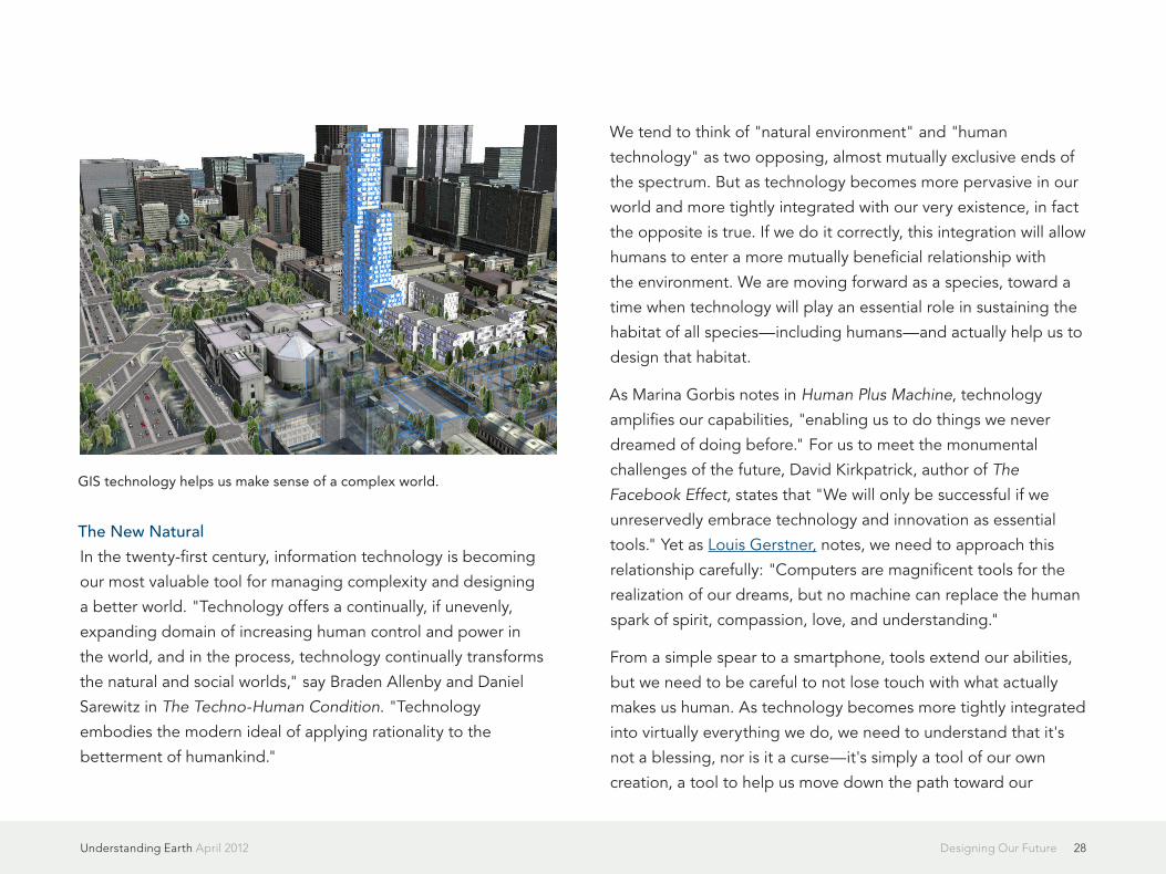
GIS technology helps us make sense of a complex world.
Understanding Earth April 2012 29Designing Our Future
destiny. Or, as Allenby and Sarewitz note, "Technology is neither
the answer nor the question, it's just the condition."
The Future of Cities
Seven billion. That number has received a lot of attention recently
as global population has grown past this mark. But lost in the
media coverage of this milestone was another, perhaps even
more fascinating global statistic: more than 50 percent of those
7 billion people now live in cities, a number projected to grow
more than 75 percent during this century. In fact, there will be at
least 19 cities in the world with a population greater than
20 million by the end of the twenty-first century. Cities are human
destiny.
Clearly, cities will play an increasingly important role in our future
survival. Cities offer easier access to services, and urban dwellers
are more efficient consumers of limited resources. But as our
cities become more populous and more numerous, how do we
best manage this complexity?
We need to start thinking about cities in a different way:
• Reimagining the canvas—Fundamental to changing the way
we think about cities is a reimagining of the way we abstract
them. GIS technology gives us a powerful new context
for extending our traditional methods of abstracting the
geography of cities—a new canvas that includes everything
that lies below, on, above, and around the city, including
what exists inside and outside buildings, as well as how
things connect to the city and how all of these things change
through time.
• Cities as ecosystems—Cities are the places where most of
us now spend the vast majority of our lives. They have in
fact become man-made ecosystems. Recognition of cities as
the primary habitat for the human species is leading to new
approaches to their management and design. GIS technology
has long been used to map, study, analyze, and manage
natural ecosystems. It only seems logical to manage, model,
and design our new man-made ecosystems with the same
tried and true tools.
• Buildings as microcities—As our cities are growing in size and
complexity, so too are the buildings that make up much of
the fabric of the city. In effect, many buildings and facilities
are becoming small cities themselves, and they need to be
designed and managed as such. GIS tools, used successfully
for many years in fields such as environmental analysis
and landscape planning, also support a broad range of
applications inside and outside buildings and facilities.
• An engaged citizenry—Smart cities of the future will be
those where citizens are engaged in their design and
evolution, where the collective intelligence of the masses is
leveraged and everyone can actively participate in shaping
the community. GIS technology has already proved to be an
Understanding Earth April 2012 30Designing Our Future
effective tool in supporting citizen engagement. Intelligent
web maps are acknowledged as catalysts for solving key
challenges in creating a dialog through informed citizens.
As web and cloud-based GIS continues to evolve and
social media and mobile devices become more pervasive,
governments will continue to deliver innovative forums
through interactive information and participatory citizen
applications.
• Designing future cities—Geodesign is a concept that
enables architects, urban planners, and others to harness
the power of GIS to design with nature and geography in
mind. Geodesign results in more open participation through
visualization, better evaluation of proposed scenarios, and a
deeper understanding of the implications of one design over
another. Combining the strengths of data management and
analysis with a strong design and automation component is
fundamental to designing the cities of the future.
Cities are intricate collections of materials, infrastructure,
machinery, and people, with countless spatial and temporal
relationships and dependencies. They require progressively more
sophisticated tools for their design and management. They are
complex systems where we humans spend an increasing amount
of our lives.
Our challenge is to design our man-made ecosystems to achieve
the maximum benefit to society while minimizing short- and
long-term impacts on the natural environment. As an integrative
platform for the management and analysis of all things spatial,
GIS technology can help meet this challenge.
Cities are our new man-made ecosystems, and it's time we start
to think about them, manage them, and design them as such.
The Climate Challenge
Earth's climate has undergone radical changes in the distant as
well as the recent past and is almost certain to undergo more
radical changes in the not-too-distant future. As industrialization,
population, and urbanization continue to increase, so too will
stressors on the environment, such as pollution. Such change in
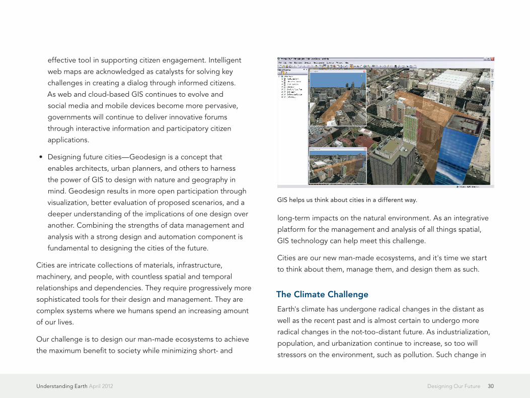
GIS helps us think about cities in a different way.
Understanding Earth April 2012 31Designing Our Future
climate and environmental quality could have huge implications
for quality of life. Regardless of where each of us stands on the
often politically charged issue of global climate change, we owe
it to ourselves and our children to take an informed look at the
scientific data and develop actionable, intelligent alternatives.
We live in an age of readily and freely available information. The
Internet has given us unprecedented awareness of and access to
vast quantities of climate data. Never before have scientists and
nonscientists had such easy and open access to the data and
tools needed to study the earth's climate. Both past observations
and future predictions are useful in studying climate change.
Examining and cross-referencing past and future data can help
quantify changes already occurring as well as predict patterns
and trends that could impact climate in the near- and long-term
future.
For decades or longer, and for thousands of locations around
the globe, humans have been keeping careful records of rainfall,
temperature, lake levels, streamflows, and so on. Beyond these
historical records, additional records of climate change stretch
back even farther; consider the fields of dendrochronology, which
measures the size of tree rings and reveals climate data stretching
back for thousands of years, and palynology, which examines
changes in the type and distribution of fossil pollen and gives us
clues about climate that go back millions of years. The result of
all this information collection and research is vast stores of data
describing conditions at particular locations on the planet at
particular points in time.
For years, scientists have been using sophisticated computer
models in an attempt to visualize the future of earth's climate.
The output of a particular model can be enlightening, but using
GIS to combine data from multiple models and sources, both
past and future, gives us the best chance for a comprehensive
and accurate vision of what the future holds for our planet.
The Next Generation
Many industries have suffered during the current economic
downturn. So why is it that during this same period, demand for
geospatial technology professionals has grown significantly?
We think that this trend is due to the growing understanding
of the value of spatial information and analysis. There are many
reasons to implement GIS, but the benefits that we see driving
organizations in lean times are cost savings resulting from greater
efficiency. And as we come out of this economic downturn, the
efficiencies realized from GIS will become a standard way of
doing business, so the need for geospatial professionals will
increase even more.
Government has long been at the forefront of this movement,
and there will be opportunities here for people with geospatial
knowledge, most notably in the area of homeland security
and the agencies concerned with increased transparency and

Understanding Earth April 2012 32Designing Our Future
accountability. But we're now seeing a huge shift in momentum
in the commercial arena. Many of the future career opportunities
for geospatial professionals will be in the private sector, as
businesses increasingly realize the benefits that government has
understood for some time.
The current high unemployment rate is sending a lot of
experienced workers "back to school" to learn new skills more
relevant to the twenty-first-century workplace. This is one
factor driving the growth of focused geospatial programs at
universities and community colleges, both at the degree level
and the certificate level. These programs are doing a great
service by training the geospatial work force of tomorrow. They
are also providing many opportunities for seasoned geospatial
professionals to take on new roles themselves—passing on their
vast knowledge by instructing and teaching the next generation
of geospatial professionals.
But the career opportunities here are not just for the people who
sit in front of keyboards and "do GIS." It's much bigger than that.
The real growth opportunity is in the area of spatial thinking. As
people in all types of positions become more familiar with the
value of geography, they begin to ask more intelligent questions
about the world, and they begin to make better informed
decisions.
The future looks bright for the next generation of spatial thinkers.
And these are the people who are going to change the world.
A New Understanding
Maps have long been used by man for communicating and
understanding. Today, modern mapping and GIS technology
drive a new relationship between humans and the environment,
giving us the geographic understanding we need to proactively
design a better future.
As the reach of spatial information expands, new opportunities are created for spatial thinkers in many areas.
Understanding Earth April 2012 33About the Authors
About the Authors
Jack Dangermond founded
Esri with a vision—that
computer-based mapping and
analysis could make significant
contributions in the areas
of geographic planning and
environmental science. The
recipient of 10 honorary doctorate degrees, he has served
on advisory committees for the National Aeronautics and
Space Administration, the Environmental Protection Agency,
the National Academy of Sciences, and the National Science
Foundation.
Matt Artz writes for Esri
about the value of using GIS
technology to advance scientific
understanding.

Copyright © 2012 EsriAll rights reserved.Printed in the United States of America.
The information contained in this document is the exclusive property of Esri. This work is protected under United States copyright law and other international copyright treaties and conventions. No part of this work may be reproduced or transmitted in any form or by any means, electronic or mechanical, including photocopying and recording, or by any information storage or retrieval system, except as expressly permitted in writing by Esri. All requests should be sent to Attention: Contracts and Legal Services Manager, Esri, 380 New York Street, Redlands, CA 92373-8100, USA.
The information contained in this document is subject to change without notice.
US Government Restricted/Limited RightsAny software, documentation, and/or data delivered hereunder is subject to the terms of the License Agreement. The commercial license rights in the License Agreement strictly govern Licensee’s use, reproduction, or disclosure of the software, data, and documentation. In no event shall the US Government acquire greater than RESTRICTED/LIMITED RIGHTS. At a minimum, use, duplication, or disclosure by the US Government is subject to restrictions as set forth in FAR §52.227-14 Alternates I, II, and III (DEC 2007); FAR §52.227-19(b) (DEC 2007) and/or FAR §12.211/12.212 (Commercial Technical Data/Computer Software); and DFARS §252.227-7015 (DEC 2011) (Technical Data – Commercial Items) and/or DFARS §227.7202 (Commercial Computer Software and Commercial Computer Software Documentation), as applicable. Contractor/Manufacturer is Esri, 380 New York Street, Redlands, CA 92373-8100, USA.
Esri Trademarks and Service Marks: @esri.com, 3D Analyst, ACORN, Address Coder, ADF, AML, ArcAtlas, ArcCAD, ArcCatalog, ArcCOGO, ArcData, ArcDoc, ArcEdit, ArcEditor, ArcEurope, ArcExplorer, ArcExpress, ArcGIS, ArcGlobe, ArcGrid, ArcIMS, ARC/INFO, ArcInfo, ArcInfo Librarian, ArcLessons, ArcLocation, ArcLogistics, ArcMap, ArcNetwork, ArcNews, ArcObjects, ArcOpen, ArcPad, ArcPlot, ArcPress, ArcPy, ArcReader, ArcScan, ArcScene, ArcSchool, ArcScripts, ArcSDE, ArcSdl, ArcSketch, ArcStorm, ArcSurvey, ArcTIN, ArcToolbox, ArcTools, ArcUSA, ArcUser, ArcView, ArcVoyager, ArcWatch, ArcWeb, ArcWorld, ArcXML, Atlas GIS, AtlasWare, Avenue, BAO, Business Analyst, Business Analyst Online, BusinessMAP, CommunityInfo, Database Integrator, DBI Kit, EDN, Esri, Esri—Team GIS, Esri—The GIS Company, Esri—The GIS People, Esri—The GIS Software Leader, FormEdit, GeoCollector, Geographic Design System, Geography Matters, Geography Network, GIS by Esri, GIS Day, GIS for Everyone, GISData Server, JTX, MapIt, Maplex, MapObjects, MapStudio, ModelBuilder, MOLE, MPS—Atlas, PLTS, Rent-a-Tech, SDE, SML, Sourcebook·America, SpatiaLABS, Spatial Database Engine, StreetMap, Tapestry, the ARC/INFO logo, the ArcGIS logo, the ArcGIS Explorer logo, the ArcPad logo, the Esri globe logo, the Esri Press logo, the GIS Day logo, the MapIt logo, The Geographic Advantage, The Geographic Approach, The World’s Leading Desktop GIS, Water Writes, arcgis.com, esri.com, geographynetwork.com, gis.com, gisday.com, and Your Personal Geographic Information System are trademarks, service marks, or registered trademarks or service marks of Esri in the United States, the European Community, or certain other jurisdictions.
Other companies and products mentioned herein may be trademarks or registered trademarks of their respective trademark owners.
Printed in USA
Contact Esri
380 New York Street Redlands, California 92373-8100 usa
1 800 447 9778 t 909 793 2853 f 909 793 5953 [email protected] esri.com
Offices worldwide esri.com/locations
Esri inspires and enables people to positively impact their future through a deeper, geographic understanding of the changing world around them.
Governments, industry leaders, academics, and nongovernmental organizations trust us to connect
them with the analytic knowledge they need to make the critical decisions that shape the planet.
For more than 40 years, Esri has cultivated collaborative relationships with partners who share our
commitment to solving earth’s most pressing challenges with geographic expertise and rational resolve.
Today, we believe that geography is at the heart of a more resilient and sustainable future. Creating
responsible products and solutions drives our passion for improving quality of life everywhere.
G53017 ESRI4/12ek
Recommended