BRITISH COLUMBIA 111• S... l'l.tae 1111 Eird,
Ministry of Energy and Mines BC Geological Survey
Assessment Report Title Page and Summa1-y
TYPE OF REPORT [type of survey(sl]: Geological Assessment Report TOTAL COST: $ 3,780.00
AUTHOR(S): D.G. (Dan) Cardinal, P. Geo. , F.G.A.C.
NOTICE OF WORK PERMIT NUMBER(S)/DATE(S): YEAR OF WORK: 2017 ----------------------STATEMENT OF WORK-CASH PAYMENTS EVENT NUMBER(S)/DATE(S): Event No. ID 5662309; Recorded Date 2017/AUG/30
PROPERTY NAME: APEX CLAIM
CLAIM NAME(S) (on which the work was done): Apex (1046424) -"'--~---"'---------------------------
COMMODITIES SOUGHT: SOAPSTONE
MINERAL INVENTORY MINFILE NUMBER(S), IF KNOWN: -----------------------------
MINING DIVISION: New Westminster
LATITUDE: 50 o 02 °43 ---OWNER(S):
NTS/BCGS: NTS: 0921/4 BCGS: 091.002
LONGITUDE: 121 o 37 °07 --- (at centre of work)
1) Dan Cardinal 2) ----------------------
MAILING ADDRESS:
PO Box 593, 380 Dewdney Avenue
Hope, BC VOX 1 LO
OPERATOR(S) [who paid for the work]:
1) Same 2) ----------------------
MAILING ADDRESS:
PROPERTY GEOLOGY KEYWORDS (lithology, age, stratigraphy, structure, alteration, mineralization, size and attitude):
Bridge River Terrane, Kowiek Creek Fault, Mississippian - Permian, serpentinite, ultramafic, talcose schist,
soapstone, talc, magnesite. accretonary, fault-contact, phyllite, graphitic-quartz schist.
REFERENCES TO PREVIOUS ASSESSMENT WORK AND ASSESSMENT REPORT NUMBERS: 4985, 13634, 22665, 25411, 30564 & 31003
Next Page

TYPE OF WORK IN EXTENT OF WORK ON WHICH CLAIMS PROJECT COSTS THIS REPORT (IN METRIC UNITS) APPORTIONED
(incl. support)
GEOLOGICAL (scale, area)
Ground, mapping 750mx750m 1046424 $3,000.00
Photo interpretation
GEOPHYSICAL (line-kilometres)
Ground
Magnetic
Electromagnetic
Induced Polarization
Radiometric
Seismic
Other 4x4 Truck, Base Camp & materials 106424 $780.00
Airborne
GEOCHEMICAL (number of samples analysed for ... )
Soll
Slit
Rock
Other
DRILLING (total metres; number of holes, size)
Core
Non-core
RELATED TECHNICAL
Sampling/assaying
Petrographic
Mlneralographlc
Metallurgic
PROSPECTING (scale, area)
PREPARATORY/ PHYSICAL
Line/grid (kilometres)
T opographic/Photogrammetric
(scale, area)
Legal surveys (scale, area)
Road, local access (kilometres)/trail
Trench (metres)
Underground dev. (metres)
Other
TOTAL COST: $3,780.00
EVENT NUMBER: 5662309
GEOLOGICAL ASSESSMENT REPORT
GEOLOGICAL MAPPING SURVEY CONDUCTED ON MINERAL TENURE 1046424 FOR SOAPSTONE POTENTIAL
(Work Conducted: Aug. 5 – Aug. 9, 2017)
Centre Of Work: Lat. 50o02’43”; Long. 121o37’07”
NTS: 092I/4 BCGS: 092I002
NEW WESTMINSTER MINING DIVSION
REPORT PREPARED BY:
D.G. (DAN) CARDINAL, P.GEO., F.G.A.C.
380 DEWDNEY AVENUE PO BOX 593
HOPE, BRITISH COLUMBIA
APRIL 5, 2018
TABLE OF CONTENTS:
A. INTRODUCTION 1.
B. MINERAL TENURE INFORMATION 1.
C. LOCATION AND ACCESS 1.
D. BRIEF HISTORY 4.
E. MAPPING AND SAMPLING PROCEDURE 4.
F. REGIONAL GEOLOGY 5.
G. PROPERTY GEOLOGY AND SOAPSTONE MINERALIZATION 5.
H. CONCLUSION - SOAPSTONE POTENTIAL 6.
I. REFERENCES 8.
J. STATEMENT OF EXPLORATION EXPENSES 9.
K. PROFESSIONAL CERTIFICATE 10.
MAP FIGURES:
LOCATION MAP Figure 1. 2.
REGIONAL GEOLOGY - MINERAL CLAIM MAP Figure 2. 3.
PROPERTY GEOLOGY MAP Figure 3. 7.
PHOTOGRAPH:
Photo 1. Cascade Grizzly Bear Carving 6.
Photo 2. Grizzly Bear Carving
A. INTRODUCTION:
The object of geological surveys conducted on the Apex claim (tenure 1046424) was to confirm and assess the potential of soapstone mineralization historically documented on the property. Historical (1990-94) work carried out in this area outlined ‘talc’- soapstone mineralization. Geological mapping and selected soapstone samples were collected and submitted to a professional carver for testing for carving characteristics and qualities. This field work was conducted for 4 days between August 5 and August 9, 2017.
Apex claim encompasses 41.5 ha. and covers a known talc-soapstone occurrence. It occurs along the southeastern end of the Kwoiek Creek ultramafic serpentinite belt and is accessible from the community of Boston Bar. Soapstone samples collected for art-carving potentials display characteristics similar to soapstone imported from Brazil.
B. MINERAL TENURE INFORMATION:
Claim Name: Apex; Tenure No. 1046424; Hectares: 41.50; Acquisition Date: Sept. 2, 2017; Good to Date: Sept. 30, 2021; Claim Registered to: Dan Cardinal.
The mineral claim falls within the administration of the New Westminster Mining Division with its administration offices located in city of Kamloops, BC.
C. LOCATION AND ACCESS:
The property is located in southwestern British Columbia at Latitude: 50o02’43”N and Longitude: 121o37’07”E on NTS mapsheet 092I/4. UTM co-ordinates for the property and project site is on Zone 10, 5545000N – 599000E situated at elevation of about 1680 metres.
It is accessible from the community of Boston Bar via crossing the Fraser River bridge to the village of North Bend and onto a gravel base all-weather road for 15 km across the Nahatlatch River. From this point a branch road (splitting to the right) leads to the property for additional 15 km. This section of road requires a four-wheel drive vehicle and passes by a former forestry fire-lookout tower (now in seasonal use by the Lower Mainland 4-wheel drive club) located at elevation of about 1,200 metres and continues to the property for total of about 30 kilometres.
1.

LennacZymoPitman
Shan
Silver Queen
FoxZakco
TagaiBlackwater East
Galileo
Black Bear
Irony
Ptarmigan
CastleTulameen
PrincetonGreenwood
Redford
Atlin
Premier EastDunwell
Silver VistaRoman Mountain
Pearson
Quesnel Trough
Engineer
Taurus
Big Bull
Thorn EagleheadGalaxie
North RokGJ
Waterloo
JD
Newmont Lake
Red CliffPremier
Homestake RidgeDolly Varden
Porphyry CreekBellTrek MAC
Silver Hope
Nithi MountainBerg
Ootsa Coles Creek
Capoose
3Ts
Blue RiverWoodjam
Lac La HachePeach Lake
Newton
Salal
Copper Mountain
Arctos
Groundhog
Raven
Coal Cre
Turnagain
Akie
Kemess North
Bronson Slope
Kwanika
Lone Pine
Deer Horn
J&L
Elk
Elizabeth
EB
Michel Head
Williston
Mink Creek EastHudette
Bowron River
Carbonatite Syndicate
Heart Peaks
KeyTrapper
EldoradoCirque
DOK
Kinskuch
Captain
North Island Logan CopperWest ValleyRateriaNIC
Roger's CreekPoplar
Slocan Group
Big KiddKenvilleKena
Wild Rose
Anyox
BA
Huguenot
Dazo
Northern Dancer
Snowfield
Blue River
Getty
Iron Ross
Adriana
Carbon East
Graham RiverDunlevy
Peach Reach
Perry Creek
Telkwa Belcourt Saxon
Crowsnest
Pacific Iron
Peace River
Cinnabar Peak
Lucky Ship
Horse Creek
Fort NelsonFort NelsonFort NelsonFort NelsonFort Nelson
MackenzieMackenzieMackenzieMackenzieMackenzie
TerraceTerraceTerraceTerraceTerracePrince RupertPrince RupertPrince RupertPrince RupertPrince Rupert
Fort St. JohnFort St. JohnFort St. JohnFort St. JohnFort St. John
Dawson CreekDawson CreekDawson CreekDawson CreekDawson Creek
QuesnelQuesnelQuesnelQuesnelQuesnel
Williams LakeWilliams LakeWilliams LakeWilliams LakeWilliams Lake
RevelstokeRevelstokeRevelstokeRevelstokeRevelstoke
Salmon ArmSalmon ArmSalmon ArmSalmon ArmSalmon Arm
VernonVernonVernonVernonVernon
KelownaKelownaKelownaKelownaKelowna
PentictonPentictonPentictonPentictonPentictonTrailTrailTrailTrailTrail
VancouverVancouverVancouverVancouverVancouverNanaimoNanaimoNanaimoNanaimoNanaimo
VictoriaVictoriaVictoriaVictoriaVictoria
Port HardyPort HardyPort HardyPort HardyPort Hardy
Bella CoolaBella CoolaBella CoolaBella CoolaBella Coola
MassetMassetMassetMassetMasset
ValemountValemountValemountValemountValemount
BRITISH
COLUMBIA
APEX CLAIM
LOCATION MAP APEX CLAIM BCGS: 092I.002
UTM: ZONE 10 5544500N-599000E New Westminster Mining Divison
FIGURE 1.
2.

603000
602000
601000
600000
599000
598000
597000
596000
595000
5
5542000
APEX CLAIM For Detail See Figure 3
Access Road
Logging Road Deactivated
Scale Bar: 1 km
1:31000 (approx.)
Campsite
Look-Out Tower
REGIONAL GEOLOGY – MINERAL CLAIM MAP
LEGEND
Late Cretaceous – Paleogene : granodioritc rocks
Jurassoc-Cretaceous: Cayoosh Assemblage, clastic sedimentary rocks. Mississippian-Middle Jurrassic: Bridge River Complex marine sedimentary & volcanic rocks.
Mississippian-Middle Jurassic: Bridge River Complex serpentinite ultramafic rocks. Cretaceous-Tertiary High grade metamorphic rocks.
FIGURE 2.
SOAPSTONE MAPPING PROJECT – APEX CLAIM TENURE 1046424
KWOIEK CREEK SERPENTINE ULTRAMAFIC BELT
3.

D. BRIEF HISTORY:
Between late 1980s to mid-1990s exploration was conducted along parts of the Kwoiek Creek serpentine-ultramafic belt in search for talc mineralization by various resource companies. Interest was generated in part by the provincial government and private sector, west coast pulp and paper industry for potential application of ‘value added’ industrial minerals such as talc. Talc, due to its certain physical characteristics, has certain application in paper making both as filler, coating pigment and pitch control.
During this period a number of soapstone deposits hosted along the serpentine belt were identified as potential talc resource. The Apex claim was one such area, based on historical reports analyses of soapstone contained some 60-65% talc and 35-40% magnesite. Trenching and limited stripping from this time exposed soapstone outcrops. Gradual interest for value added minerals waned as the papermaking industry began to compete with the paperless technology age – ‘email’. Consequently, talc as potential filler in the industry ceased.
The author of this report acquired the Apex claim in 2016 to explore soapstone quality for artistic carving purposes, as much of the quality soapstone for professional carving is imported mainly from South America such as Brazil. As a result, in August 2017 preliminary surveys were carried out on the property orientated toward indentifying possible carving characteristics of the soapstone and its quality.
E. MAPPING AND SAMPLING PROCEDURE:
Mapping surveys were conducted utilizing a hand held garmin GPSmap 64, which was upload with MapSource product. Rock outcrops encountered during the survey were marked onto the MapSource. GPS surveys were within +/- 1-3 metres accuracy of plotted bedrock outcrop. As well, maps downloaded from MTO map place were produced at a scale of 1:5000 for field mapping purposes with geology and bedrock outcrops mapped plotted onto maps. Field notes of the daily surveys were documented in combination with GPS mapping geodata.
A base camp was established at elevation 1680m immediately adjacent to the project site.
Soapstone samples were obtained from 2 different sites. These sites were selected because of the soapstone characteristics, which included: massive (i.e. no fractures) nature, little surface iron oxidation, little to no impurities such as magnesite, chromite or iron carbonate, smooth texture, soapy feel and ease of carving with pocket knife. The samples were extracted with a chain saw with some of the samples weighing as much as 55-60kg. Some of these samples were
4.

then donated to local professional native carvers and native craft outlets interested in testing a local source.
F. REGIONAL GEOLOGY:
Regionally, the property partly covers the southeastern extension of the Kwoiek Creek serpentinite ultramafic belt (Figure 2). It represents a deep seated, transpressional structural break, which trends northwest-southeast traceable for some 35km. The serpentinized ophiolitic belt makes up part of the Bridge River Terrane oceanic complex also referred to as the Bridge River Complex. It regionally forms Mississipian to Middle Jurassic age accretionary oceanic rock assemblages including the Cayoosh Assemblage consisting of marine clastic rocks. Tectonically, the overall structural fabric is complex with highly foliated and steeply dipping bedrock and trending northwesterly. It represents several overprinted deformations (D1-D3) and schistosity (S1-S3), which reflect docking of Bridge River Terrane to the leading edge of Quesnellia Terrane during Middle-Late Jurassic.
To the northwest and southeast of the property are 2 post accretionary intrusive stocks of Cretaceous to Paleogene age comprised dominantly medium grain, biotite granodiorite.
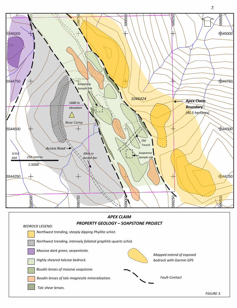
G. PROPERTY GEOLOGY AND TALC MINERALIZATION:
The property is dominantly underlain by talcose schist and soapstone in fault contact with northwest striking, steeply dipping, foliated phyllite and graphite quartz schist. A talcose type rock referred to a ‘talcose body’ hosting large boudin-like, intercalating buff to creamy coloured talc-magnesite lenses with massive bodies of soapstone. Based on the old trenches and stripping the talcose body itself, is a large lensoid feature traceable for some 250-300 metres with its widest section about 100 metres. It is in fault-contact with phyllite and graphitic-quartz schist. Fault-contact is represented by intense shearing as displayed by talcose schist.
There are mainly 3 types of talc mineralization: (i) pure, homogeneous talc lenses sometimes exhibiting large light green, pearly lustre flakes are with associated with the fault-contact and between lensoid bodies of talc-magnesite and soapstone occurring as anastomosing stringers; (ii) large lenticular bodies of massive talc-magnesite visually containing 50-60% fine, light green talc flakes and remaining yellowish-creamy magnesite crystalline mineral grains , usually showing surface oxidation with a thin crust of chocolate brown colour coating; (iii) soapstone is characteristically massive lenticular bodies up to several metres wide and several metres long. It is commonly comprised of very fine talc mineralization with occasional blebs of black chromite
5.
and creamy green colour and greenish-yellow to light buff coloured marbled flows. It usually displays buff coloured surface oxidation.
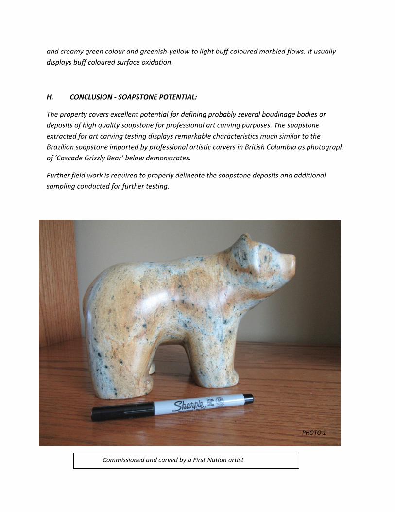
H. CONCLUSION - SOAPSTONE POTENTIAL:
The property covers excellent potential for defining probably several boudinage bodies or deposits of high quality soapstone for professional art carving purposes. The soapstone extracted for art carving testing displays remarkable characteristics much similar to the Brazilian soapstone imported by professional artistic carvers in British Columbia as photograph of ‘Cascade Grizzly Bear’ below demonstrates.
Further field work is required to properly delineate the soapstone deposits and additional sampling conducted for further testing.
PHOTO 1
Commissioned and carved by a First Nation artist
Northwest trending, steeply dipping Phyllite schist.
Northwest trending, intensely foliated graphitic-quartz schist.
Massive dark green, serpentinite.
Highly sheared talcose bedrock.
Boudin lenses of massive soapstone.
5985
0059
8500
5985
0059
8500
5985
0059
8500
5985
0059
8500
5985
0059
8500
5987
5059
8750
5987
5059
8750
5987
5059
8750
5987
5059
8750
5987
5059
8750
5990
0059
9000
5990
0059
9000
5990
0059
9000
5990
0059
9000
5990
0059
9000
5992
5059
9250
5992
5059
9250
5992
5059
9250
5992
5059
9250
5992
5059
9250
5995
0059
9500
5995
0059
9500
5995
0059
9500
5995
0059
9500
5995
0059
9500
55442505544250554425055442505544250 55442505544250554425055442505544250
55445005544500554450055445005544500 55445005544500554450055445005544500
55447505544750554475055447505544750 55447505544750554475055447505544750
55450005545000554500055450005545000 55450005545000554500055450005545000
Base Camp
Access Road
1680 m elevation
30km to Boston Bar
1046424 Apex Claim Boundary (40.5 hectares)
Soapstone Sample site
Soapstone Sample Site
250 metres
1:5000
SCALE BAR
APEX CLAIM PROPERTY GEOLOGY – SOAPSTONE PROJECT
Boudin lenses of talc-magnesite mineralization.
Talc shear lenses.
Mapped extend of exposed bedrock with Garmin GPS
Fault-Contact
BEDROCK LEGEND:
FIGURE 3.
7.
Old Trench

I. REFERENCES:
Cardinal, D.G., April 8, 2013, Event No. 5427670, Geological Assessment Report, Geological Reconnaissance Mapping And Sampling Survey (Evidence of Orogenic-Related Sedimentary-Hosted & Intrusive Related Gold Mineralized Systems On The Dot-Apex Claim Group, BC Ministry of Energy, Mines and Natural Gas (and Responsible for Housing).
Cardinal, D.G., December 13, 2013, Event No. 5468701, Geological Assessment Report, Geological Mapping And Sampling Follow-Up Surveys (An Orogenic Gold Related System – Arsenopyrite Proxy To Potential Gold Sites) On The Dot-Apex Mineral Claim Group, BC Ministry of Energy, Mines and Natural Gas (and Responsible for Housing). Chamberlain, J.A., 1973, Geological Report, H Claims, Nahatlatch Area, BC, Department of Mines and Petroleum Assessment Report No. 4985. Clowes, R.M., Zelt, C.A., Armor, J.R., and Ellis, R.M., 1995, Lithospheric structure in the southern Canadian Cordillera from a network of seismic refraction lines, in Cook, F.A., (Special Editor), the southern Canadian Cordillera transect of Lithoprobe, Canadian Journal of Earth Sciences, v.32, no.10, p1485-1513. Duffel, S. and McTaggart, K.C., 1952, Ashcroft Map Area, British Columbia, Geological Survey of Canada, Memoir 262. Goldfarb, R.J., Hart, C.J.R. and Marsh, E.E., 2008, Orogenic gold and evolution of the Cordilleran orogen, Arizona Geological Society Digest 22, 2008. Horwood, H.C., 1936, Preliminary Report on the Nahatlatch Region, GSC Paper 36-7. Jaroslav Dostal, J. Duncan Keppie, B. Neil Church, Peter H. Reynolds, and Cheryl R. Reid, February 8, 2008, The Eocene-Oligocene magmatic hiatus in the south-central Canadian Cordillera: a capture of the Kula Plate by the Pacific Plate?, Can. J. Earth Sci. 45: 69-82 (2008). Journeay, J.M. and Monger, J.W.H.,1994, Terranes Of The Southern Coast And Intermontane Belts, British Columbia, GSC, Scale 1:500,000. Lennan, W.B., 2011, (NI-43-101)Technical Summary Report on the Dot-Apex Claim Group (Private In-house report). Lefebure, D.V. and Hart Craig, May, 2005, Plutonic-Related Au Quartz Veins & Veinlets L02, British Columbia Geological Survey. Monger, J.W.H., 1989, Geology of Hope and Ashcroft Map Area, British Columbia, GSC, Maps 41-1989 and 42-1989. Taylor, K.J. (Hudson Bay Exploration & Development Co. Ltd.), March 1985, Diamond Drill Report for the Natch 1-4 Claims, Boston Bar Area, BC, Geological Branch Assessment Report No. 13634.
8.

Schiarizza, P., 2013, The Wineglass assemblage, lower Chilcotin River, south-central British Columbia: Late Permian volcanic and plutonic rocks that correlate with the Kuthcho assemblage of northern British Columbia, Geological Fieldwork 2012, Ministry of Energy, Mines and Natural Gas, British Columbia Geological Survey Paper 2013-1. Umhoefer, P.J., P. Schiarizza, and M. Robinson, 2002, Relay Mountain Group, Tyaughton-Methow basin, southwest Britsh Columbia: a major Middle Jurassic to Early Cretaceous terrane overlap assemblage, Canadian Journal of Earth Science.
Umhoefer, P.J., Schiarizza, P., 1996, Latest Cretaceous to early Tertiary dextral strike-slip faulting on the southeastern Yalakom fault system, southeastern Coast Belt, British Columbia, Special Paper 487, The Geological Society of America, July, 1996, v.108, no.7, p. 768-785.
J. STATEMENT OF EXPLORATION EXPENSES:
Mapping and sampling surveys on the Apex claim, 4 days between August 5 and August 9, 2017.
Field Crew: Cost
Geologist: 4 days @ $500 per day. $ 2,000.00 Assistant: 4 days @ $250 per day. 1,000.00
Field Related Expenses:
Base Camp and Groceries: 380.00 4x4 Truck: 4days @ $100 per day 400.00
Total Expenses Incurred: $3,780.00
Respectfully Submitted;
9.
Daniel G. Cardinal, P. Geo., F.G.A.C.
K. PROFESSIONAL CERTIFICATE:
I, Daniel G. Cardinal, of Hope, British Columbia, do hereby certify that: • I am a Professional Geoscientist and reside at 380 Dewdney Avenue, Hope, B.C. V0X 103. • I am a graduate of the University of Alberta (1978) and received a 2 year technical diploma in Exploration-Geology from the Northern Alberta Institute of Technology (1972). • I am member in good standing with the Association of Professional Engineers and Geoscientists of British Columbia (P.Geo.), membership #18455; a member in good standing with the Association of Professional Engineers, Geologists and Geophysicists of Alberta (P.Geol.), membership #M29405; a Fellow of the Geological Association of Canada (FGAC) and, ,member ID #9166924 with The Geological Society Of America. • I have practiced my profession continuously for the past 35 years. • I am the registered owner of the Apex mineral claim with Tenure No.: 1046424 • I am the author of this report herein submitted as Event Number 5662309 and, that I have conducted the field work documented in this report. Signed in Hope, BC this 6th of April, 2018.
10.
D.G. (Dan) Cardinal, P. Geo., F.G.A.C.
Recommended