Embed Size (px)
Citation preview
of this REPORT is very simple and straightforward it is that Portland Oregon is
not and never was a seaport much less a first class deep-ocean port Instead it is
quite simply only a second-class seaport 80 miles from the ocean situated inland upriver on a major watercourse -- the
majestic Columbia -- and thereby only up a carefully manicured shipping channel that requires not just maintenance
dredging but 80 continuous miles of such dredging no less meticulous dredging as well as a commensurate ongoing
effort at channel-marking buoy marking and day-to-day satellite monitoring for navigational hazards and fluctuations in
channel-depth This is accomplished through a demanding tight-knit and very high-tech collaboration between the US
Coast Guard the Army Corps of Engineers the Port of Portland and the Columbia River Pilots Association Oh yes
and did we mention that even after being dredged to 44rsquo maintenance of the channel-depth to guarantee commercial cargo
shipping viability requires an additional complex balancing act between the Bonneville Power Administration the
Northwest Water Council and the Columbia River Pilots
In addition to the costs to the taxpayer of maintaining this system trans-shipment of commercial goods from the mouth of
the river at ASTORIA on the ocean to Portland or vice versa is impossible without 100 pilotage of each vessel to call
ndash adding thus 160 miles of pilot fees to the costs imposed on each vessel which in turn adds not only additional fuel costs
to the trip and labor costs in man-hours but also creates exposure to risk of loss to the vessel and cargo thereby ndash despite
the excellent track-record of the River Pilots -- adding also to insurance costs for each merchant vesselhellip
SUCH ADDITONAL COSTS incurred on commercial shipments are significant enough to render Portland entirely
non-competitive as against other US Pacific ocean ports Seattle-Tacoma San Francisco and Los Angeles ndash certainly at
least for trans-Pacific shipments Commercial interests in Portland and at the Port of Portland nevertheless have not only
kept Portland and the Oregon citizenry straining to maintain the illusion that Portland can ldquomake itrdquo as a seaport against
this competition Sorry itrsquos the physical facts Donrsquot fight laws of physics and expect to win
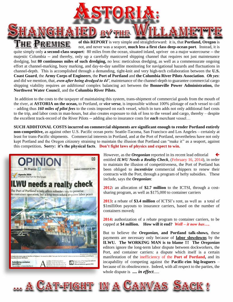
However as the Oregonian reported in its recent lead editorial
entitled ILWU Needs a Reality Check (February 16 2014) in order
to maintain the illusion of competitiveness the Port of Portland has
been obliged to incentivize commercial shippers to renew their
contracts with the Port through a program of hefty subsidies These
include says the Oregonian
2012 an allocation of $27 million to the ICTSI through a cost-
sharing program as well as $175000 to container carriers
2013 a rebate of $34 million of ICTSIrsquos rent as well as a total of
$1milli0on payouts to insurance carriers based on the number of
containers moved
2014 authorization of a rebate program to container carriers to be
capped at $4 million How will it end Well ndash it now hashellip
But to believe the Oregonian and Portland talk-shows these
payments are necessary only because of labor slowdowns by the
ILWU The WORKING MAN is to blame The Oregonian
editors ignore the long-term labor dispute between dockworkers the
Port and container carriers a dispute which itself is a certain
manifestation of the inefficiency of the Port of Portland and its
incapability of competing against the Pacific-rim big-leaguers ndash
because of its obsolescence Indeed with all respect to the parties the
whole dispute is in effect
which is not to use the technical terminology a win-win situation for either cat OKAY So
Itrsquos obviously past time THIS REPORT will serve to remind readers of a just few neglected facts of a hydrographic
and geographical nature -- ndash almost all of them self-evident facts -- that have a fundamental bearing on Oregon economics
under the category of merchant shipping These simple facts ndashglaringly obvious but blindly overlooked -- once intelligently
observed cannot but be recognized by any sane mind Indeed the desirability of ASTORIA as THE PRIMARY
OREGON PORT is hardly just another debatable item among a number of so-called ldquocontributionsrdquo to some never-ending
ldquoongoing dialoguerdquo on the matters of Port of Portland operations or regional economic development generally On the
contrary development at Astoria has the characteristic of a physical economic imperative for Oregon ndash period But it is
an imperative which has for far far too long gone ignored and which precisely because it has lain nearly a century
neglected now reveals itself to be the one highly urgent amp critical radical reform necessary to save the Oregon economy
IF YOU DOUBT THIS PLEASE REFER AGAIN TO hellip
Since February 10 2014 -- the date of HANJINrsquos announcement that it would no longer call at the Port of Portland -- a
Pacific Coast labor dispute between the ILWU and Pacific coast port operators affecting 26 West coast ports was
effectively settled httpblogseattlepicomseattlepolitics20150220deal-reached-to-settle-west-coast-ports-dispute-full-
operation-by-saturday-night The longshoremenrsquos union -- ILWU -- proved quite negotiable with port operator ICTSI
Oregon despite what the Oregonian newspaper and various Portland radio stations like KXL would have the public
believehellip Thus while 25 other West coast ports will remain open for business continuing uninterrupted operations
HANJIN operations will still cease at the Port of Portland -- effective March 9 2015 The reason according to Hanjinrsquos
spokesman Mike Radak is simple the company ldquocanrsquot afford the expense of operatingrdquo in Portland
Additionally the ICTSI which contracts for the management of actual dock operations at the Port of Portland1 has
announced that it too will leave port of Portland once Hanjin ceases to call This effectively shuts down container
shipping at the port httpwwworegonlivecombusinessindexssf201502port_of_portland_container_ter_2html
The US Department of Commerce released numbers Thursday February 26 2015 that Oregon exported $204 billion
mostly in computers and electronics agricultural goods machinery -- a record-breaking year The Oregon export
industry supported 92000 American jobs according to the data
SO ndash ASK YOURSELF THE QUESTION IS THERE STILL TIME TO LOSE
OREGON MUST RELOCATE ITS PRIMARY PORT FACILITY BACK TO ASTORIA
The parties involved ndash the International Longshoreman amp Warehousemanrsquos Union Local No No28 the ICTSI and
the Port of Portland are not alone in this CRISIS but they ndash like the Oregon citizenry at large -- would be wellndashadvised
to reconsider the wisdom of fighting each other over a pie that has been shrinking for decades and can only shrink further
Such recurrent embittering infighting only represents the underlying long-term problem of economic geography that
Portland is just no-longer a competitive port internationally whereas Astoria is and is destined to be
Not only the Portland ILWU Local No 28 but locals up and down the river in Kalama Local No 4 Longview Local
No 21 and Astoria No 50 and elsewhere should lobby their representatives in Salem amp Washington DC to liberate
Astoria and thus the entire region from this obsolete 19th century commercial policy Not only will such steps revitalize
the economy of Oregon ndash but will do so for the entire region
Consider the following schematic hellip of the
1 ICTSI Oregon is part of the Pacific Maritime Association a coalition with 28 other West Coast port operators who just
negotiated a new contract with the International Longshore and Warehouse Union But at Portland the ICTSI
(International Container Terminal Services Inc) has accused the dock workers of slowing down work to the point that
they are incapacitating normal port activities
The Columbia River watershed encompasses almost 16 of the land mass of the lower United States ndash and not
incidentally a bit of Canada as well It includes all of the north half of the west third of the United States all west of the
Rockies and north of the Siskiyous from the fertile plains of Utah to the grand mines of British Columbia ndash all that is
except 150 miles square of the Puget Sound watershed separated therefrom by the heavy grades of the Cascade
mountains
That means fully three quarters of Washington State all of the State of Idaho and portions of Montana Wyoming Utah
and Nevada all lie within the Columbia River watershed with the river mouth at Astoria As should be needless to say
the Columbia was completely outfitted with dams and locks during the hey-day of the administration of FDR ndash meaning
that very economical commercial transport by barge andor rail is already in place for moving goods and produce on low
grades with very few impediments towards the natural outlet of this watershed is already in place
Even as noted portions of southern British Columbia Canada and the northern-tier counties of California should
find economically viable shipping through a commercial international trans-oceanic Port outlet at the mouth of the
Columbia ndash that is given a 21st century re-envisioned amp revitalized Port of Astoria to be the trigger to development
reducing high transport amp shipping costs that have been holding back their profitability and thus their increased production
So helliphellip
DEVELOP MODERN PORT FACILITIES hellip ASTORIA hellip NOW
AS THIS REPORT will show ndash full-scale region-wide development with the Port of Astoria as the hub of regional
commercial movements is the only answer to the otherwise silly and soluble quasi-crisis between the ILWU and the Port
of Portland This is so as I said because this dispute is a mere epi-phenomenon of the outmoded role of Portland as a
regional sea-port whereas by contrast the Port of Astoria holds the real potential to compete on par with the ports of San
Francisco and Los Angeles and to outdo Seattle-Tacoma as a deep sea-port
And while this shift alone would revolutionize Oregonrsquos economy if it were to be coupled ndash as it must be -- with the
simultaneous construction of high-speed magnetic-levitation (ldquoMAGLEVrdquo) commercial rail-lines radiating from Astoria
to Portland and upriver on the Columbia as well as directly southeast from Astoria to the Tualatin valley and
further south into the Willamette valley the entire economy of the Pacific Northwest could be -- would be -- revolutionized
and integrated into an efficient THIRD MILLENIUM WORLD-CLASS SEA-PORT hellip
THINK IT CANrsquoT BE SO THINK THATrsquoS JUST AN EXAGGERATION
THAT SOUNDS EXTREME hellip but
between Astoria harbor and New York harbor
were inititiated immediately with American
settlement of the regionhellip
A single illustration will prove this The document at
left ldquoMemorial of the Citizens of Astoria Protesting
against a Removal of Distributing Port Office and Port
of Entry from Astoria to Pacific Cityrdquo is dated 1850
The new kid on the block a contender for the Customs
traffic was Pacific City Washington ndash now known as
Ilwaco
In this petition one can see that he sea-faring citizens of
Astoria were not reluctant to publicly herald the many
resemblances of the harbor at Astoria with that of New
York In this document addressed to the United States
Congress no less the petitioners argue ldquothat the relation
of Cape Disappointment to Astoria is precisely similar
to that of Sandy Hook to the city of New York that
Bakerrsquos Bay is a place of anchorage formerly used by
vesselrsquos before the discovery of the South Channel
while wind-bound in passing Capae Disappointment
that vessels passing through the South Channel whether
in our out owing to the prevalent winds of the country
helliprdquo etc
In an era before photography such claims had to stand or
fall on the credibility of their advocates Or they could
totally discredit their advocates In the instant of the
Memorial of the Citizens of Astoria shown here facts
were facts and of course the port facilities remained at
Astoria as well as the Customs House frustrating the aspirations
of the pioneering founders of Pacific City
The reason for this was ndash as we shall see ndash that the ldquonewly discoveredrdquo South Channel ran the length of the waterfront not
only at Astoria but also for many miles further westward fronting Youngrsquos Bay to the west then the Skipanon waterway
and on down to the present location of Warrrenton then a little further downriver to Tansy Point and Fort Stevens and
beyond out to the Pacific Ocean In fact below Astoria the shipping channel runs the entire remaining length of the
southern shore of the Columbia ndash that is exclusively along the Oregon side of the river thence out to sea
Every cargo container vessel that now makes its way the additional 80 miles from the mouth of the Columbia upriver to
Portland passes along this same waterfront And that waterfront from the shoreline fronting Astoria on out to sea seven
miles is ndash almost all of it -- ideally situated adjacent to the channel and thus almost ready-made for development into
helliprivalling YES perhaps even bettering that of New York hellip
In the Google Earth satellite image below I have marked with a red line the Columbia river frontage running the length
of the City Astoria waterfront from the upstream site of the original Customs House along the entire Astoria city waterfront
to Smith Point (highlighting the current TWO BERTHS at the Port of Astoria) I have mostly skipped over Youngrsquos Bay
and marked in red additional river frontage from Skipanon waterway past Tansy Point and out to Jetty Lagoon
Below the same image enlarged shows the original three piers also appearing here at the Port and again
in red showing downriver from Astoria miles upon miles of almost completely undeveloped river shoreline
THIS ENTIIRE SHORELINE lies immediately along amp adjacent to the Columbia Riverrsquos South Channel which Channel
is in fact the selfsame deep-water commercial shipping channel by which route all cargo carriers destined for the Port of
Portland already enter the Columbia beginning their 80-miles journey to Portlandhellip
hellipfollowed of course by their 80-miles journey back
Whatrsquos wrong with that picture Itrsquos that extra 160 mile-trip this additional river voyage mdash and the costs in expenses
wages pilotage fees insurance additional fuel sheer time itself etc associated with it which make the Port of Portland
simply non-competitive According to spokesman Mike Radak HANJIN just ldquocanrsquot afford the expense of operatingrdquo in
Portland And thatrsquos really why
Instead of navigating all those cargo freighters upriver to Portland consider the available alternativehellip
FIRST run the eye of your mind along that same shoreline Beginning inside Point Adams on the eastern rim of Jetty
Lagoon (shown at left below) therersquos about 7000 ft of riverfront to the Hammond Boat Basin and then another 7000 feet
to Tansy Point and the Hampton Lumber Yard Another 2000 ft approximately will reach across the Tansy CreekAlder
Creek estuary to the mouth the Skipanon Waterway just visible at bottom right of this satellite imagehellip
Thatrsquos roughly 16000 ft of riverfront all of it lying directly along the South Channel No need to check a map -- the
Google satellite image (below) confirms the proximity of the channel showing ldquoTansy Point Turn and Rangerdquo just offshore
the Hampton Lumber Mill at Tansy Point this refers to a range-marker and bearing point for bar pilots bringing ocean-
going vessels from the Pacific up to Astoria andor piloting them downriver back over the bar and out to sea
Depending on the decision to preserve the Tansy Creek estuary for
wildlife or recreational uses this frontage alone from Jetty Lagoon to
Tansy Point is between 14000 and 16000 feet ndash something approaching
three miles of frontage -- all of it lying directly on the shipping channel
There is no physical or economic reason that this frontage cannot be
developed How many deep-water berths perpendicular to the main
shipping channel can be comfortably developed along 14000 feet of
waterfront
Also directly off Tansy Point and extending northward towards the
South Channel is the historic nautical anchorage known to the earliest
sea-captains and pilots on the Columbia as CLATSOP ANCHORAGE
In the historic period this anchorage was used as far back as 1812 by the
HMS Raccoon in its early arrival at the Columbia Tansy Point was
once named ldquoRaccoon Pointrdquo after this same vessel ndash so long did the ship
lay at anchor there
Clatsop Anchorage off Tansy Point is essentially a submarine feature
unique on the muddy-bottomed Columbia estuary that enabled early
mariners to anchor their sailing vessels securely even in conditions of
storm and prolonged high winds The authorrsquos research indicates that the
anchorage must represent the submarine pilings of an early effectively
ldquoprehistoricrdquo British fort ndash probably the real amp original ldquoFort Georgerdquo ndash
very likely with a pier or piers extending out towards the shipping channel
Army Corps of Engineers maps indicate submarine ldquoruinsrdquo at this location
Thus additional set-asides along the South Channel in the neighborhood of Tansy Point will be required for marine
archeological research there so that the Clatsop Anchorage can be properly mapped sampled tested and eventually
reconstructed as a historic archaeological park and museum
Continuing eastward the next image below shows Tansy Point at the far left and Hampton Mill yards and then the dredged
channel of the Skipanon Waterway now also on the left Youngrsquos Bay at the mouth of Youngrsquos River is almost completely
silted in and within another decade will be a tidal flat even at high tide It is no longer navigable except by ducks and
shorebirds and few even of them will land there Scenic value is hellip limited Therefore on the image below I have run a
line from the mouth of the Skipanon towards the tip of the existing working piers of the Port of Astoria at Smith Point
This reflects the backfilling of Youngrsquos Bay ndash a proposal which is hardly original with the author hellip as this Report shows
This image on a greater scale shows now on the left Smith Point where the three piers and two original slips of the Port
of Astoria lie just west of the Astoria-Megler bridge to the Washington shore Setting aside a few thousand feet for Astoriarsquos
historic waterfront district and ldquocannery rowrdquo there remains another two miles of frontage up to Tongue Point behind
which are the docks of the old Coast Guard facility ndash also circled in red -- recently taken over by the Port of Astoria
ALSO IN THIS IMAGE You can make out the cargo container carrier-vessels being piloted through the main shipping
channel which ndash once again ndash lies directly off-shore the entire Astoria waterfront
There are here ndash from Point Adams to Tongue Point-- 7 miles maybe more of such shoreline all of it lying directly
along the deep-water shipping channel used by all container-cargo carriers and almost all other large commercial
vessels From Astoria you can often see a half-dozen or more of these behemoth container vessels ndash almost always owned
by HANJIN -- at anchor either awaiting a favorable tide before heading out towards the mouth of the Columbia or awaiting
a river pilot before heading up the extra 80 miles to the Port of Portland However by the time this dossier is published ca
March 9 2015 HANJIN will have dis-continued calling on the Port of Portland and there will be no container vessels
waiting at anchor in this harbor ndash for the foreseeable future
How many deep water berths could be developed long this entire Columbia harbor waterfront
10 20 30 More The pier-head-bulkhead line along the Astoria city waterfront runs very close to the shore
indicating proximity of the shoreline to the main shipping channel itself so unless this line could be safely extended docks
along this reach of the channel would have to be parallel thereto limiting the number that could be developed here Letrsquos
christen this stretch of Astoria waterfront ldquoThe Portland Docking Facilityrdquo in memory of the Port of Portland
Because the Port of Portland has NO perpendicular berths ndash not one Even when it is open for business The Port of Portland
numbers SIX terminals but in fact it has only FOUR terminals and only ldquoterminal SIXrdquo is adequate to these new-
generation container vessels With the exception of some smaller berths all Port of Portland facilities are parallel to the
channel ndashand not even to the channel of the Columbia but to the Willamette Thus looking at the map
httpwwwportofportlandcomMarine_Terminals_Mapaspx itrsquos no wonder pilotage is so critical to getting ocean-going
vessel into Portlandhellip
SO BY AIR ndash OR FROM A SATELLITE -- ASTORIA LOOKS PRETTY GOOD But hellip Is it hellip
Yeshellip letrsquos look back to an era of development when men were more consistently sensible on such subjectshellip
And hellip ldquodredgerdquo something uphellip
One of these authorities is P Donan the well-known harbor aficionado author of Astoria the Peerless Maritime Metropolis
of the Golden West Another is Sidney Dell Esq a 19th C attorney of Astoria who represented Capt George Flavel
and his business the Flavel Land and Development Co which planned improvements of port and rail facilities along the
riverfront beginning at Tansy Point and moving west from there towards Warrenton Dell wrote
The superlative ldquonoblestrdquo is used advisedly for in all particulars this region seems to be marked by Godrsquos own hand
for the site of the greatest of seaport cities This peninsula is almost an exact counterpart of that on which is
situated the City of New York The Columbia though six miles in width corresponds to the Hudson only one mile
wide however and Youngrsquos river and bay to East river which however has an extra outlet at Long Island Sound
though the Lewis and Clark [river] more than counterbalances that advantage The chief differences (all in Astoriarsquos
favor) are (1) that the New York peninsula runs north and south with the course of the Hudson while Astoriarsquos
peninsula runs east and west with the course of the Columbia on the great lines of travel and commerce of the world
(2) the lower end of the New York peninsula is flat while the Astoria peninsula is high and affords ample dirt for
filling in its bay down to its bulk head line under its recent seawall charter and at the same time affords scope for
the finest graded and drained seaport city in the worldhellip
The South side of the Columbia in Clatsop county though somewhat hilly by reason of the vast number of its
streams is flat land as compared with the high and rocky land on the north side and its facility of access over the
low Nehalem hills and along the sea coast south to California and southeast to the Willamette valley and east taken
with its grand bays and harbor marks it as the only great natural site for the seaport of the mighty Columbia and its
thousand valleys great and small Sea coast lines from San Francisco and from the Willamette valley and the
southeast even if a preferable point were on the north side could not with advantage cross over wide bays Tanzy
Point and south side of Youngrsquos Bay corresponding to Brooklyn are important parts of this great seaport
site They can furnish railway yards equal to those on the Jersey shore opposite New York and are part of the great
plan of nature to fix a seaport on a grand scale at this point for the Columbia watershed2
Archibald A Schenk principal assistant engineer of the NY Central Railroad during the late 19th C submitted a
professional analysis for publication in the Astorian of January 27 1891 ndash over 120 years ago -- highlighting the necessary
and inevitable role of Astoria as a deep-water seaport opining that it even must supplant Portland
ldquoThe arranging of the harbor lines and the bill to be presented to the legislature for seawall construction as referred
to in the Astorian of January 11thare two of the most important steps in advance Astoria has yet taken Track
room for the storage of cars (loaded and empty) and angle of approach are together the measure of the seaport
There may be deep water and room for a thousand ships still the business may be limited b y the land facilities
The possibility of building long piers at right angles to the channel is where Astoria is strong as contrasted with
Portland No port with such a long pier system is impossible is likely to be a port of first importance and Portland
will feel this before many years Such piers as are customary in large seaports would reach nearly across the
Willamette River at Portland Hence Portlandrsquos shoreline being available only for ships lying parallel with the
stream will be quickly used up and really amounts to but a small fraction of what ordinary seaports require
ldquoThe long pier system for use in connection with railways requires also turning room for trains back from the
piers about 350 feet say or a total of 800 to 11000 feet Hence the difficulty of Portlandrsquos becoming an extensive
seaport
Etc PROPHETIC WORDS
As important as has become the Port of Portland as a deep water port for ocean shipping nevertheless ndash as events have
now proven -- it is intrinsically inefficient and according to Sidney Dell and experts he cited such as Schenk its inland
location makes Portland only a third class port and destined to remain one Portlandrsquos forte will be as a manufacturing
center and as a rail and air transit hub for the larger Columbia river region Astoria is DESTINED to surpass it
Astoria ldquohellip is about to achieve greatness only through her own overmastering destinyrdquo
2 See Dell ASTORIA AND FLAVEL The Chief Seaport of the Columbia River Watershed (1893)
Word on the street is this in the Globalized Shipping Economy hellip
NOT OREGON Not the Columbia River hellip
Since the Port of Portland has been effectively SHUT DOWN by the HANJIN pull out it is really unnecessary for the
author here to provide an exhaustive history of cargo traffic through the Port of Astoriamdash being as Astoria must now be
recognized as is here again argued to be Oregonrsquos ldquopearl in the roughrdquo ndash a perfectly magnificent world-class deep water
seaport the neglect of which over the last 100 years or so gives Oregon and the entire Pacific Northwest region (or at least
so much thereof as lies within the Columbia River watershed ) an undreampt of amp unparalleled opportunity to jump-
start Oregon into an aggressively competitive 21st C economic ldquopower-portrdquo
Now that Governor Bike-Path Task Force has
resigned there is nothing wrong with Oregon
economy that wonrsquot be remedied by the outright
relocation of the SHIPPING HUB or center of our
international port activity from Portland to
Astoria
One glance at these historic dollar-value figures is
sufficient to shift the burden of proof in favor of
Astoria These numbers show dollar value of exports
and imports at Astoria and at Portland for the year
1879 Click to enlarge this tablehellip
At Astoria prior to almost any publicly funded port
improvements domestic exports were valued at $2M
while those at Portland were valued at $3M ndash
effective parity in terms reflecting port capacity
Astoria handled roughly 375000 tons of coastwise
cargo entered and the same volume cleared for
coasting traffichellip
Portland handled roughly 200000 tons of coastwise
cargo entered and the same volume cleared for
coastal trade
This breakdown for 1879 can only serve as a snapshot
of port potential showing Astoria running effectively
neck-in-neck with Portland based upon dollar
volume ndash and without assistance from the feds 3
These stats would be roughly repeatable for any given year
or series of years during the 19th century and it was certainly the consistent -- and consistently growing -- port volume in
and out of Astoria that recommended to the businessmen of Astoria that they should undertake the major modernization
and expansion plans of 1913-1918 that form the core of this report hellip
3
EVER READ THE FOOTNOTES TRY THIS ONE These figures were compiled as part of a survey of
Lieut A H Payson Army Corps of Engineers and compiled in a report dated November 16 1878
published in Ex Doc No 50 Forty-fifth Congress Third Session The same report details Congressional
appropriations ndash even during this early period -- were entirely dedicated towards improvements of the
Columbia River channel ldquofrom Portland to the seardquo -- and that there were NO MONIES invested in
improvements at the Port of Astoria
SO it was then that in 1913 the Port of Astoria purchased a 56-acre parcel along the main-shipping channel of the
Columbia River north of Smithrsquos Point and began engineering of the 3 modern commercial shipping piers shown in the
engineering plans below These original 1914 progress drawings for the Port show planning was for ldquoextensive harbor
developmentrdquo And the evidence suggests it was rapid development
Shown at left an early engineering
diagram illustrating the phasing in of
the development of the three units of
the Portrsquos initial facility In this
drawing solid lines represent
completed work while dotted lines
show projected facilities We can see
that when these plans were drawn
Pier No 1 was already completed
while Pier No 2 was just proposed
Meanwhile Pier No 3 even in
conception remains a mere stub with
only sufficient acreage to
accommodate ldquoFuture freight shedsrdquo
See ldquoHarbor Improvements for the
Port of Astoriardquo Engineering and
Contracting p 38 Vol XLI No 16
(1914) [Google Book]
Note that rail-lines are indicated
showing rail service to be provided to
each side of each terminal and on Pier
1 as many as a dozen short rail
sidings leading into the ldquofreight shed
for local and coastwise shippingrdquo
Also above written at Slip No 2 off Pier 2 you can make
out the words ldquoEnd of Deep Waterrdquo and see that beyond
this point the inshore of Slip No 2 has been subdivided
into smaller slips for smaller ships and fishing vessels This
is a fairly advanced and efficient ldquomulti-userdquo concept
Shown at right in a later engineering diagram Pier 1 has
been completed ndash outfitted with multiple rail-sidings and
service stubs to the warehouse Pier 2 is also complete in
its base and ldquoSand fillrdquo is indicated and as envisioned is
partially dedicated to port
The Astoria Sanitary and Reclamation Commission approved these engineering plans for Port Development
construction of a seawall and some backfill work at their
meeting on April 15 1914
An announcement that the Portrsquos development plans were being put out for bid ran in this May 31 1914 issue of the
Oregonian
Note above that there were four components to the
improvement plan in addition to the development of the
municipal docks there was to be construction of the Astoria
sea-wall building of the Columbia highway up to Westport ndash
and one other project the first of those listed here is for the
constructions of the ldquoSpokane Portland amp Seattle docks at
Flavelrdquo ndash meaning a rail terminal near the very mouth of the
Columbia We will come back to this plan in Part II of this
Report
Meanwhile on the Astoria docks three terminals were
initially planned in a phased development to be brought into
service likewise over a period of years at a cost that must have
staggered the mind ndash almost $4000000
$4000000 in 1913 -- inflation adjusted to 2015 values -- is
about $1 billion dollars That gives us an idea of just how
serious and how aggressive the Port of Astoria and its
commercial associates were in their planning for what would
be OUR FUTURE
And with that actual modern development intending to tap the
almost limitless potential of this great harbor was underway
This can all be studied in depth through brochures and article
in engineering journals on Google Book There was a bit of a
Letrsquos take a quick look at just what was accomplished
Jumping forward now five years from adoption of the initial development proposals
This 1919 vintage birds-eye photo shows a completed Pier 1 in the mid-ground hosting the completed 4000 bbl flour
mill which reached to seven stories and here towers over adjacent warehouses at the pier end Midtown Astoria is visible
over the top of the mill building In the foreground Pier 2 is partly visible where its ldquobusiness endrdquo includes coal bunkers
and a coal loading facility
This image precedes the great Astoria fire of 1922 so larger hotel and banking buildings are still visible near the center of
the picture while residential dwellings run up the hillside to the left rounding Smith Point The picture gives a good idea
of the tremendous scale of Port of Astoria piers and improvements
The LENGTH of PIER No 1 is 1320 ft
The LENGTH of PIER No 2 is 1300 ft
The LENGTH of PIER No 3 is 1300 ft
The WIDTH of the Willamette River at Portland runs between 300 and 600 ft
Which means that any single one of the three existing piers of the Port of Astoria NOT ONLY WOULD NOT FIT IN THE Willamette but in fact is long enough to function as a dam or bridge over the entire width of the Willamette
River ndash indeed to span the Willamette River twice or 3 or even 4 times This one set of figures alone should be enough
to highlight the virtual absurdity of continuing to expect competitive performance out of the Port of Portland ndash or out of the
ILWU ndash when they are woefully undersized relative to the ever-growing shipping carriers
This satellite image may be instructive
It shows the Columbia Bay off Astoria the three existing piers off Smith Point and the Astoria-Megler Bridge between
Washington and Oregon You can also see to the right probably anchored in the harbor two deep-water container cargo
vessels ndash undoubtedly HANJIN freighters looking smaller than grains of rice Another smaller vessel is at the right-
edge of the picture These ships that are so oversized and unwieldy at the Port of Portland are literally like fly-specks on
the Columbia at Astoria
Incidentally to see an image like this showing both the north and south shores of the Columbia Harbor one has to
rdquoascendrdquo to a higher altitude in the Google or Mapquest viewers Then of course the very altitude reduces the imagery of
the freighters to near the invisible level The width of the Columbia bay or harbor at Astoria is FOUR MILES ndash or 21
473 feet as measured by the Astoria ndashMegler bridge The width of the Hudson River at New York is about ONE MILE
Now that the reader may have a rudimentary sense of the scale of the Columbia harbor and the great capacity of the Port
of Astoria Piers ndash few though they may be -- letrsquos take an up-close look at the facilities themselves The following pages
show the three piers of the port ca 1919 ndash almost a century ago
The main entrance to Pier No 1 at the Port of Astoria featured this headquarters building which included a
yawning freight shed hellip
ldquoConstruction details of Pier No 1 Pier No 1 which has frontage of 620 feet is 1 363 feet long with a total area of
806000 square feet entirely bulk-headed and filled in Upon this pier are located a freight shed a bulk grain and storage
plant extensive railroad trackage a 4000-barrel capacity flour-mill and additional freight sheds providing 655000
square feet of covered storage space These sheds are equipped with mechanical ramps for loading and unloading
commodities from barges and vessels Eight portable conveyors are used for the handling of grain flour and other bulk
freight to and from the cars and to the shiprsquos hold Each of these conveyors handles a maximum load of 100 tons per hour
depending of course upon the labor available on the ships to stow away the3 cargo as it is loaded
ldquoChutes and sliding doors have been constructed to load sacked freight into holds The 1200000 bushel [sic] 64 tanks the
main tanks are 28 ft 6 in in diameter by 78 feet deep The flour mill a five-story structure also of concrete is also being
builtrdquo Etc
See International Marine Engineering pp 104-109 (Feb 1920)
The 4000 bbl flour mill at Pier 1 was in istself a marvel shown here as it looked in 1919
Pier No 2 is 426 wide solid fill and 1 445 feet
long Slip 1 of Pier 2 was originally dedicated to a
coal loading facility ndash shown here ndash which hosted
coal bunkers operating with gravity discharge and
apron conveyors to telescoping chutes capable of
delivering fuel directly to the shipsrsquo bunkers The
terminal was served on all sides by rails the tracks
visible in the photo above
Slip 2 of Pier 2 was dedicated chiefly to lumber and included steam locomotive cranes and an additional derrick of 20
ton capacity for loading timber some coal and other heavy packaging and equipment On the right of the diagram below
one of the locomotive cranes is loading coal into a boxcarhellip
One has to pause and reflect ndash I think -- on the values in terms of overall efficiency and worker safety and satisfaction
of a port facility like the original Port of Astoria Piers 1-3 -- a facility that was really perfectly suited for heavy cargo
export and import The Port of Astoria Piers 1-3 are mammoth even seen 100 years later Drop in on these piers in satellite
imagery at httpwwwmapquestcom (search Astoria) or Google Maps to get an impression of the scale of these ldquopeerlessrdquo
piers and related harbor improvements You can also search ldquoPortlandrdquo for aerial comparison of the Port of Portland
facilities along the Willamette facilities which -- we now know ndash have little future and in fact look positively 19th Century
At Astoria as can be seen in these pics of Pier 2 the pier frontage and length was served uninterruptedly by rails while the
breadth and depth of frontage allowed those rails to serve multiple vessels docked at the same pier at the same time and in
immediate proximity to one another ndash either at the same slip or adjacent slips which inter alia could allow for rapid
transfer of cargo not just ship to shore or vice versa but from one vessel to another Perhaps such a capability might have
a role to play in efficiencies of port operations In fact such features have to be deemed salient to every aspect of the
efficiency and viability of a Port operations ndash down to the level of worker productivity and job satisfaction
A working man ndash like a dockworker -- deserves a level of job satisfaction that can come only from knowing his working
environment is intelligently laid out with an eye on his safety as well as towards increasing productivity this is because
the workmanrsquos ability to increase his own productivity vis-agrave-vis an efficient workplace equates to being able to command
higher wages for his work which is one way he can control and plan for his own future But an inefficient workshop or
workplace creates consistent impediments to productivity frustrates creative ingenuity on the job and often creates or
triggers risk-taking at the expense of the workmenrsquos safety in other words it generally limits the working manrsquos capacity
to perform at peak ndash thereby de-capacitating profitability of the operation The workmanrsquos horizon is limited and his
aspirations to improve his condition is frustrated
At the Port of Portland the unique level of job dissatisfaction by members of the ILWU Local No 28 and its continuous
unresolved character should almost certainly be traced back to the workplace situation and re-considered in terms of the
overall INEFFECIENCY of the Port of Portland itself both in terms of its remote location from the Pacific ocean and in
its seriously compromised ldquoterminalrdquo facilities and lack of any real deep-water piers In fact the Port of Portland has NO
actual cargo piers of course ndash just berths or Terminals as they are called ndash terminal SIX being the one deep water
The real labor problem at the Port of Portland is the port itself
It is extremely likely that any dockworkers -- including ILWU workers ndash would find a virtually ideal situation
were they to be re-employed at a facility like the redeveloped fully modern PIERS of the Port of Astoria hellip
Pier 3 was to be fitted out with an export shed
and docks with the most advanced loading and
unloading equipment At left the close-up of
a cross- section of a cargo vessel at near
capacity also serves the purpose of showing
the existing depth of the channel off Smith
Point at 35 feet natural depth so dredging
even here will be necessary to handle container
carrier traffic -- as elsewhere noted the
Columbia river shipping channel is maintained
over its 80 mile length to a depth of 43 ft This
picture from 1913 probably shows seamen
unloading the steamer but therersquos a chance that
they are longshoremen
The ILWU was first organized in Portland in
1909 ndash again just about a century ago and
only a few years before the modern Port of
Astoria got underway
One wonders if the ILWU actually had more
jobs at a renewed Port of Astoria ndash that is
more jobs than they could readily FILL ndash and
if those jobs included the type of demanding
challenges associated with contributing to the
improvement and efficiency of a truly state-of-
the-art 21st C port facility ndash one in which they
could see their own workplace prospects
expanding instead of constricting as at the
Port of Portland aka Exeter on the Willamette
ndash whether then they would sense opportunity
for growth in their work setting and whether
that would in turn adequately incentivize their
workday output instead of dampening their
hopes and expectations
Therersquos not enough space in this report to even begin to cover the wide range of terminal facilities available at the Port of
Astoria as early as 1919 Some of the plans convey a better idea of the work involved better than any photographand
some of the engineering and architedtural drawings are beautifully watercolored and hand-lettered in a way that seems to
be permeated by an unspoken pride in the workmanship and scale of the project that wsa beginning at Astoria
Incidentally the Port of Astoria historical file from which these images are drawn through the courtesy of the Clatsop
County Heritage Museum which holds them also includes the plans for development of the Standard Oil terminal at
Smith Point which appears to have gone ldquoonlinerdquo around 1919
The Standard Oil terminal was located on Fifth Street Standard had 500 lineal feet of berthage with 50 feet of water at
low tide There were 16 tanks with storage capacity of 100000 bbl and could pump 4000 barrels an hour or 800 barrels
per hr into cars Car capacity was 10 railcars on the dock which was served by the Spokane Portland amp Seattle Railway
Among the Standard Oil blueprints is this inset map showing Standardrsquos ldquoAstoria Sales Territoryrdquo showing that Standard
had a fairly enthusiastic network of railroad connections running along the Pacific coasts both of Oregon and Washington
State extending as far south as Nehalem in Oregon and as far north as Oysterville on the Long Beach Peninsula
Numerous additional rail lines work their way up
Willapa Bay Washington but also climb through
some difficult terrain inland in Washington State
and meanwhile south of the river railroads also
tackle the worst of the Nehalem Mountains in
extreme northwest Oregon ndash ldquothe Horn of
Oregonrdquo ndash a desperately underdeveloped area
which is a railroading no-manrsquos land today ndash the
last working rails have having been torn off the
grade which was then turned into hellip another
valuable bike-path
Notice that Standard Oil also shows its plans for
distribution by rail along the north and south
banks of the Columbia ndash on the south as far as
Clatskanie and perhaps beyond as far as nearby
Portland One wonders why wouldnrsquot
Standard Oil rather ship petroleum upriver for
delivery to the Port of Portland FIRST and then
run the product back down the river on the
railroad
The Union Oil Co also had a terminal at Smith
Point at the same time as Standard Lineal
berthage for the Union Oil terminal was 400 ft
and there was 51 ft of water for Union steamer-
tankers at low tide Storage capacity was 14000
barrels pumping capacity was 500 barrels per
hour and 300 bblshr into cars The car capacity
of the Union siding was 4
You know therersquos nothing like the prospect of
good economic return to attract a savvy
businessman
Wonder why HANJIN left Port of Portland
Effective today March 9 2015
So thatrsquos what Astoria had going for it hellip 100 YEARS AGO
httpwwwsym-zoniacom
Inc
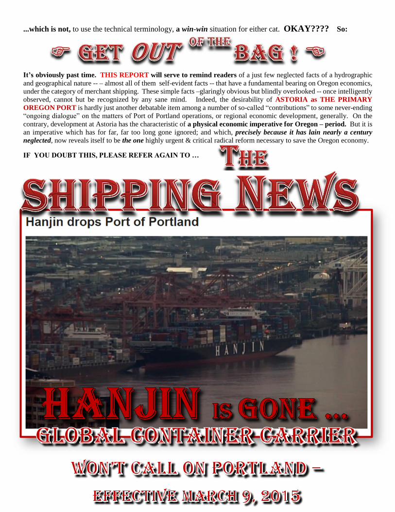
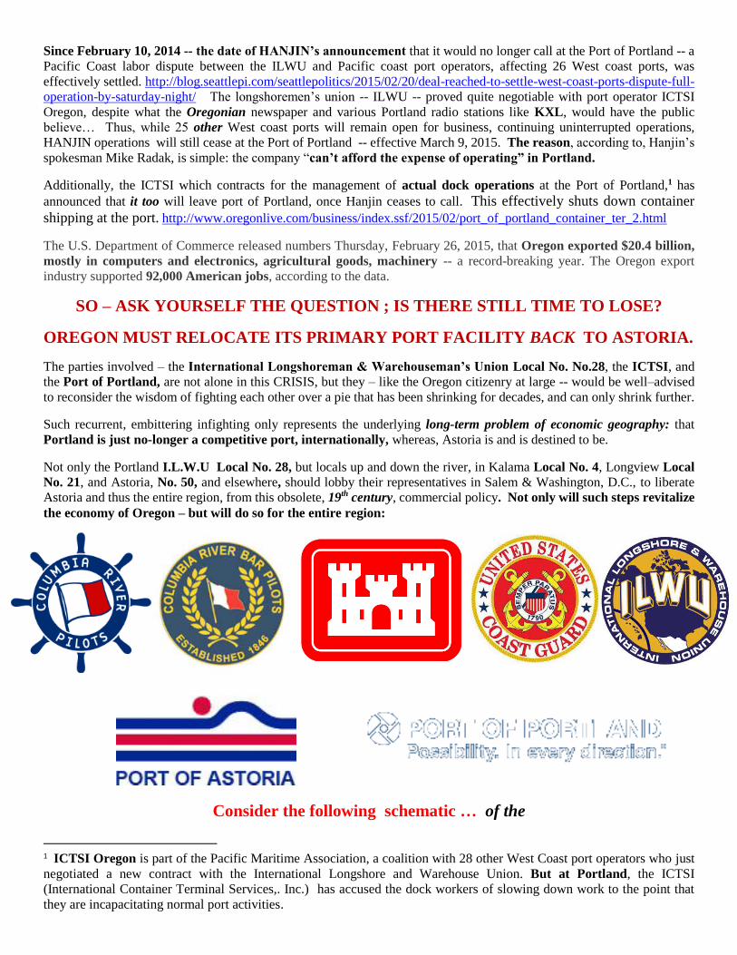
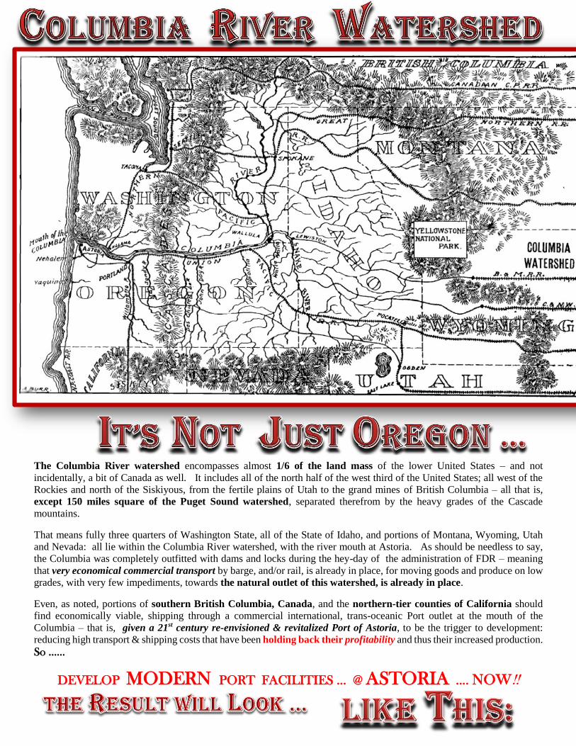
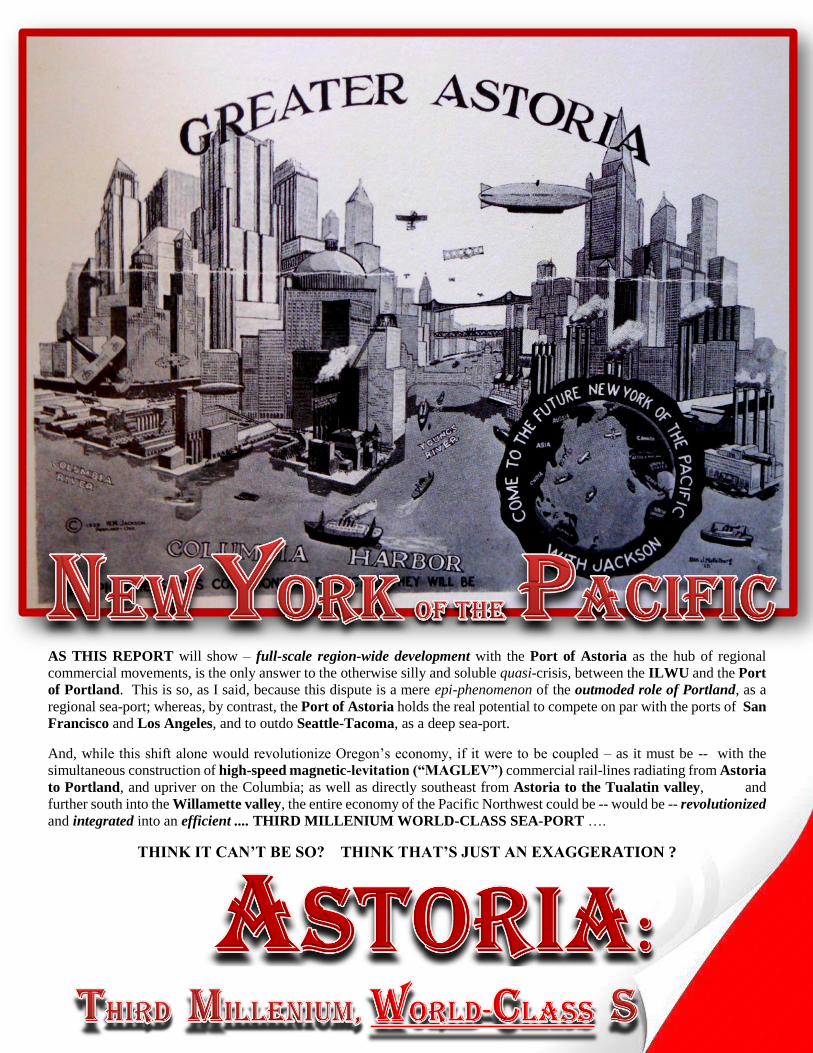
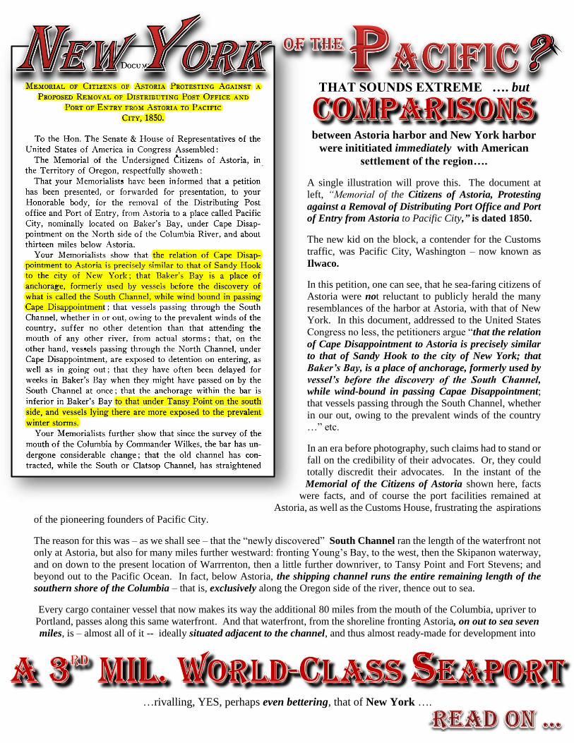
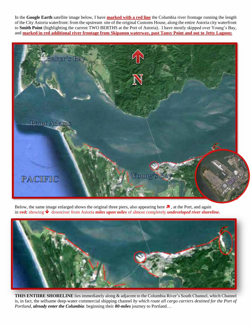
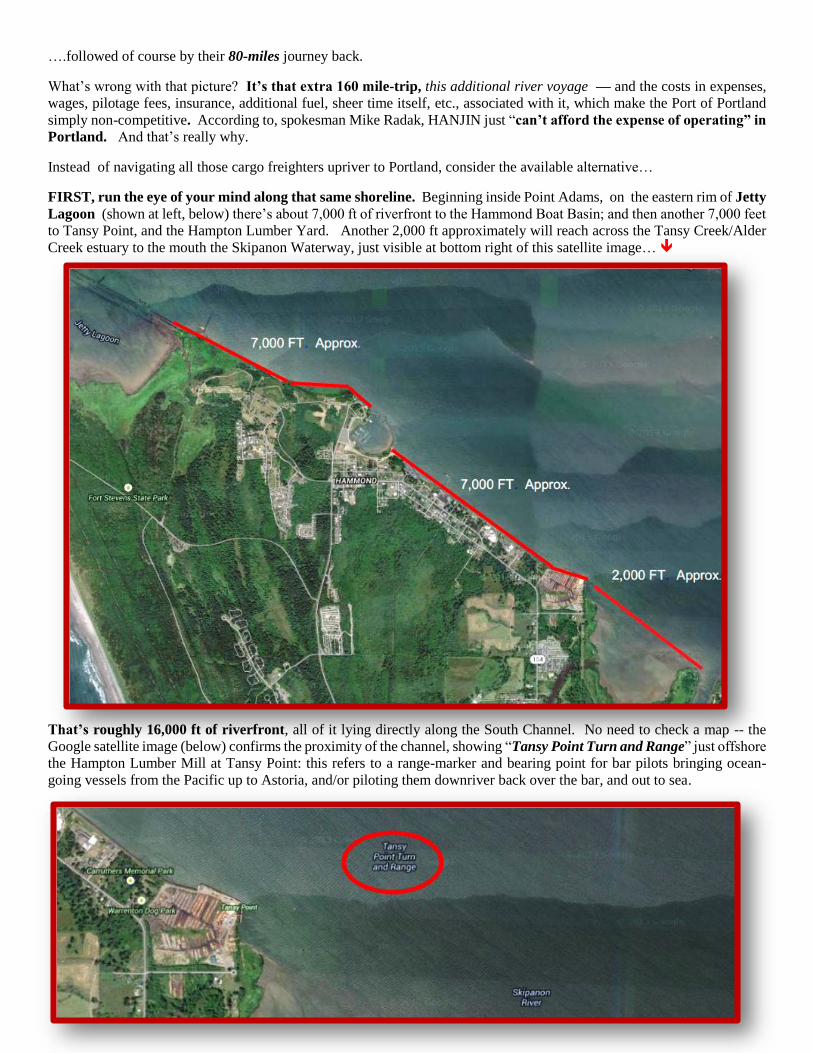
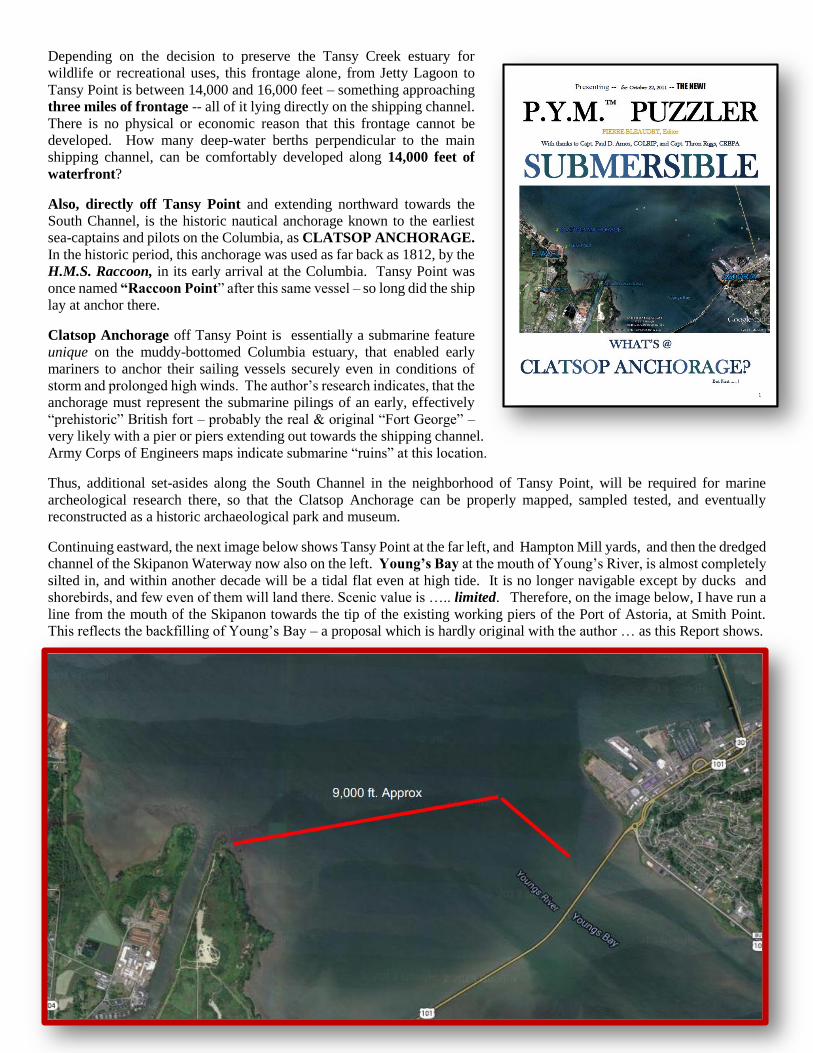
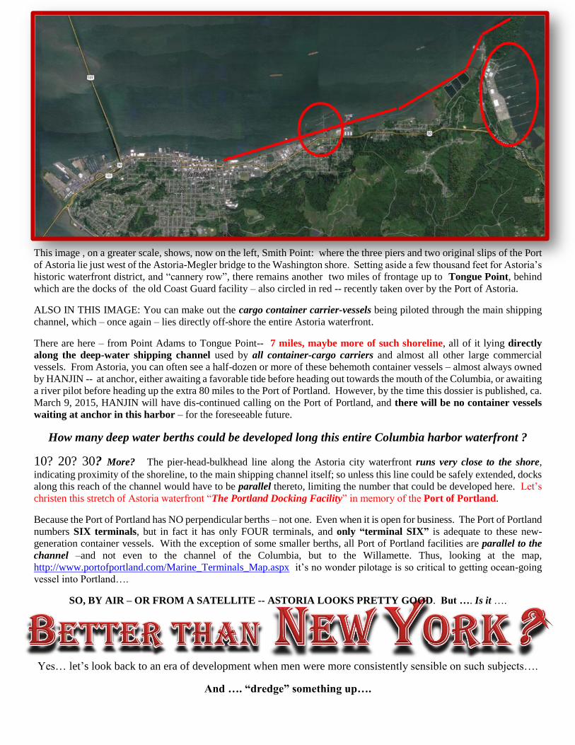
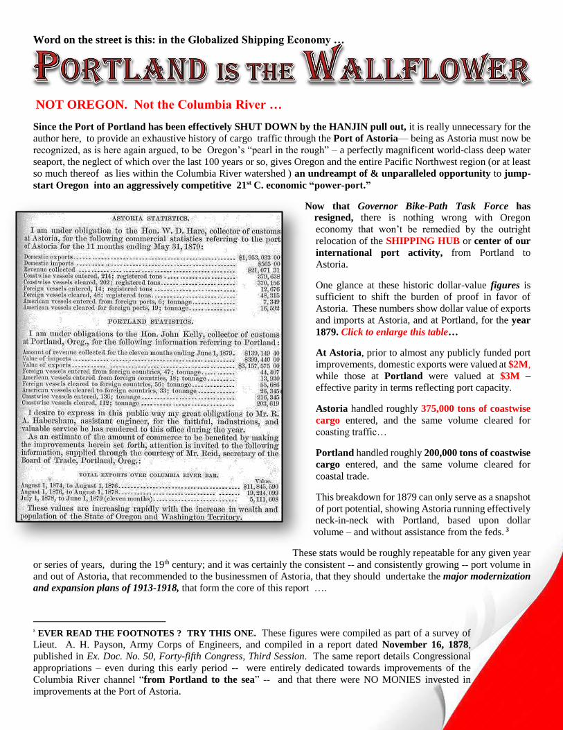
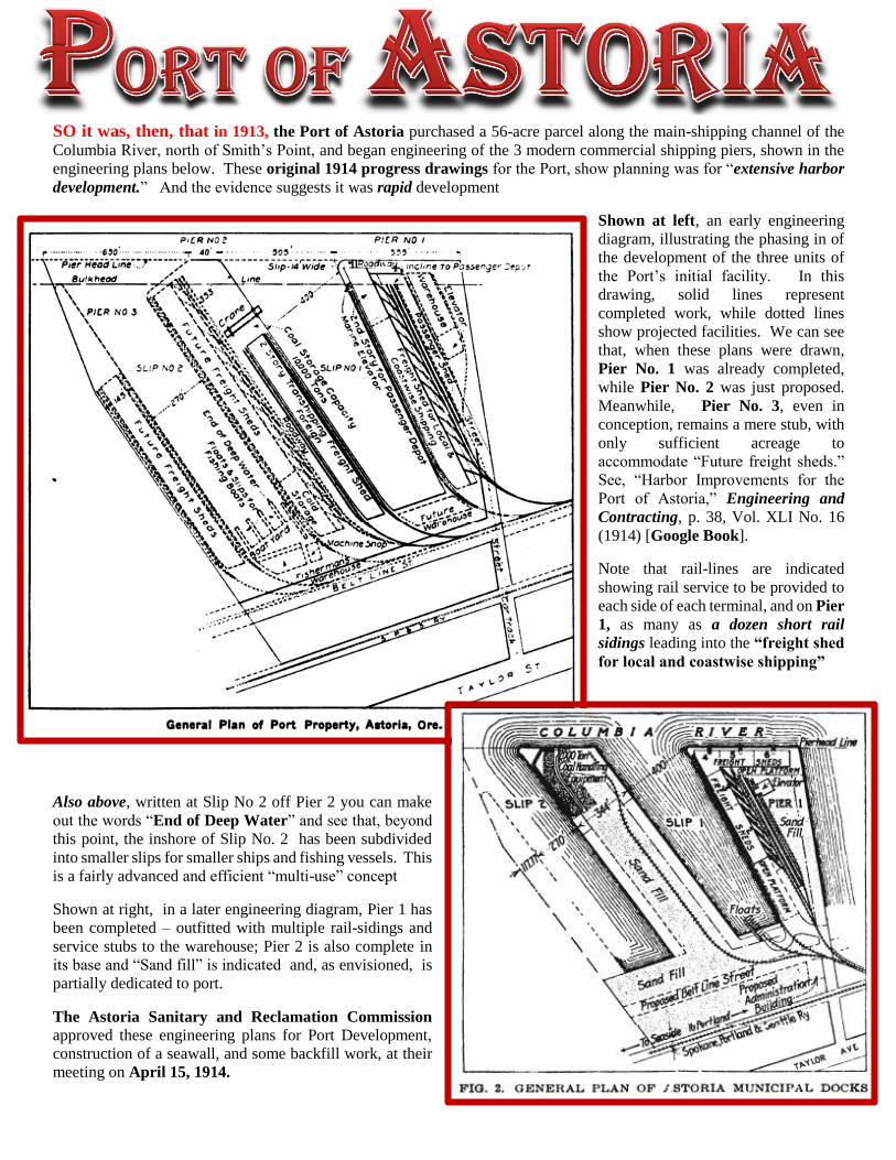
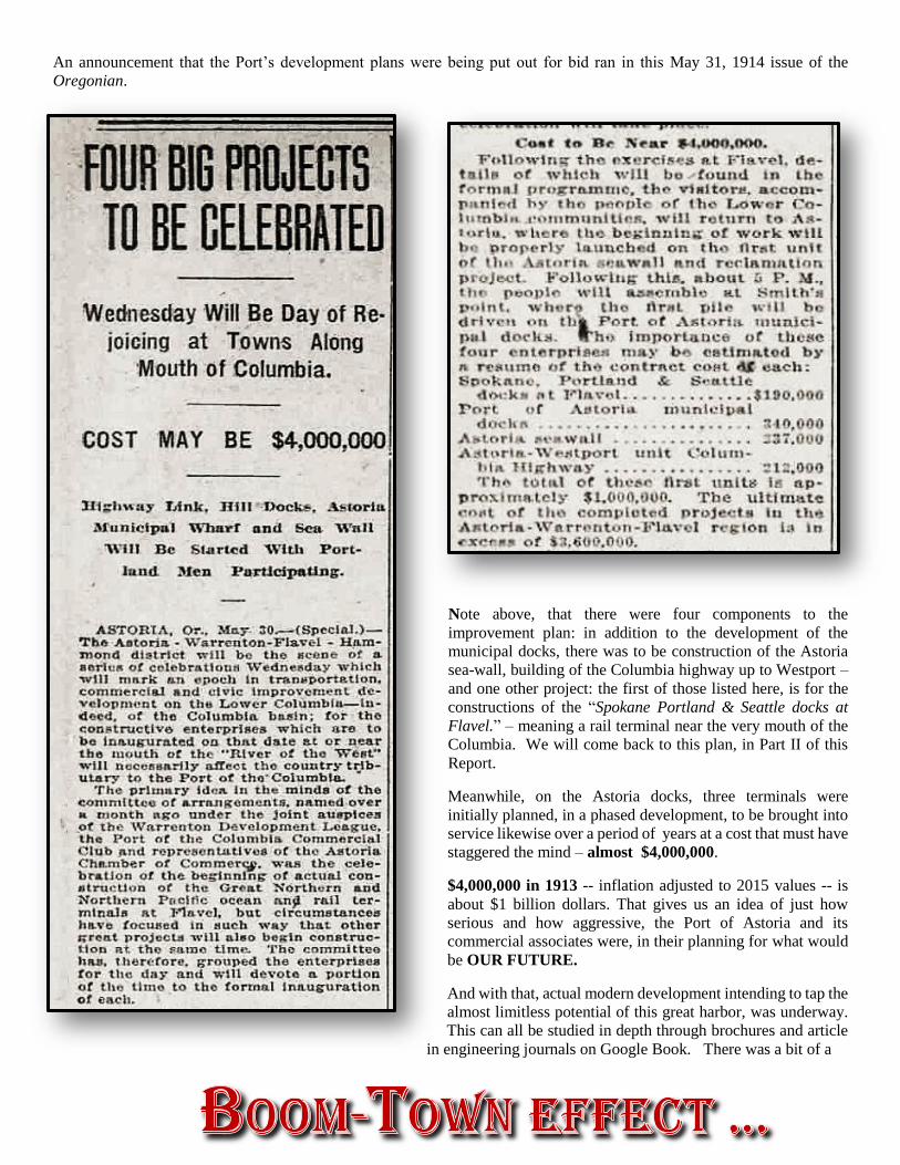
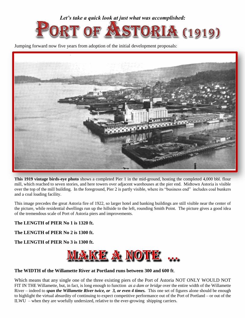
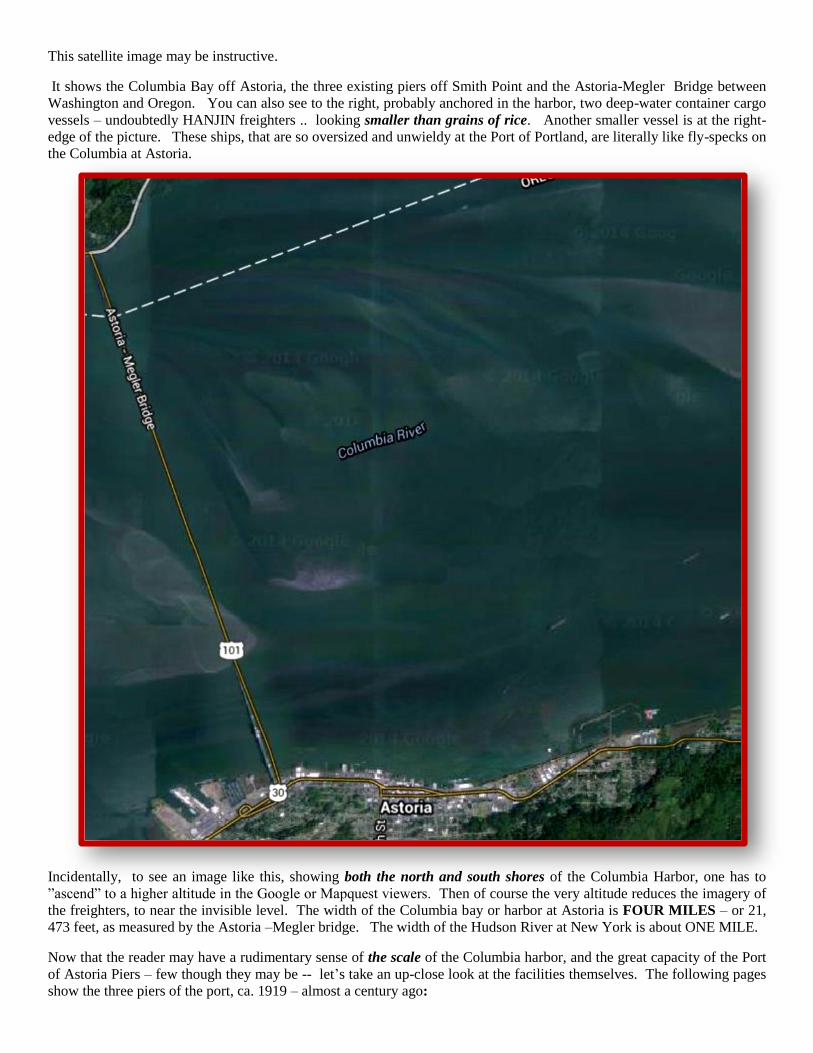
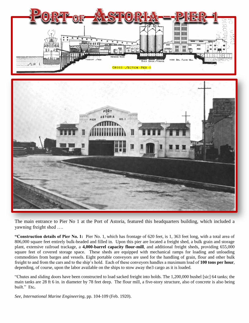
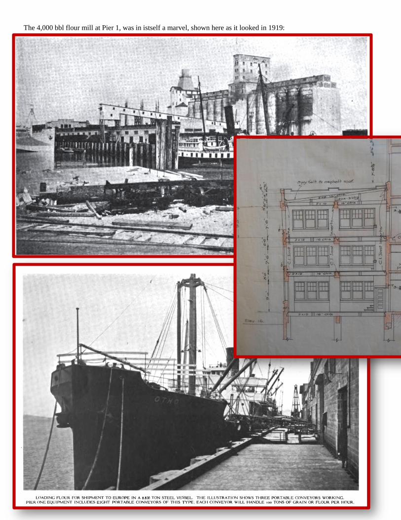
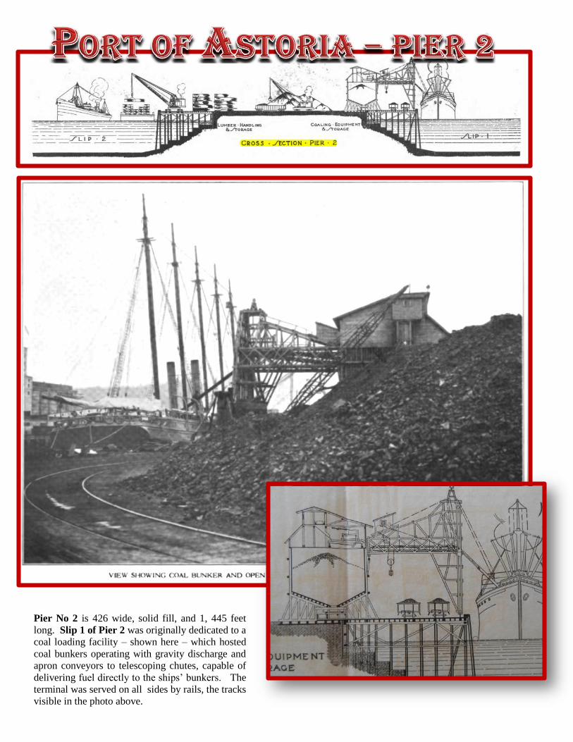
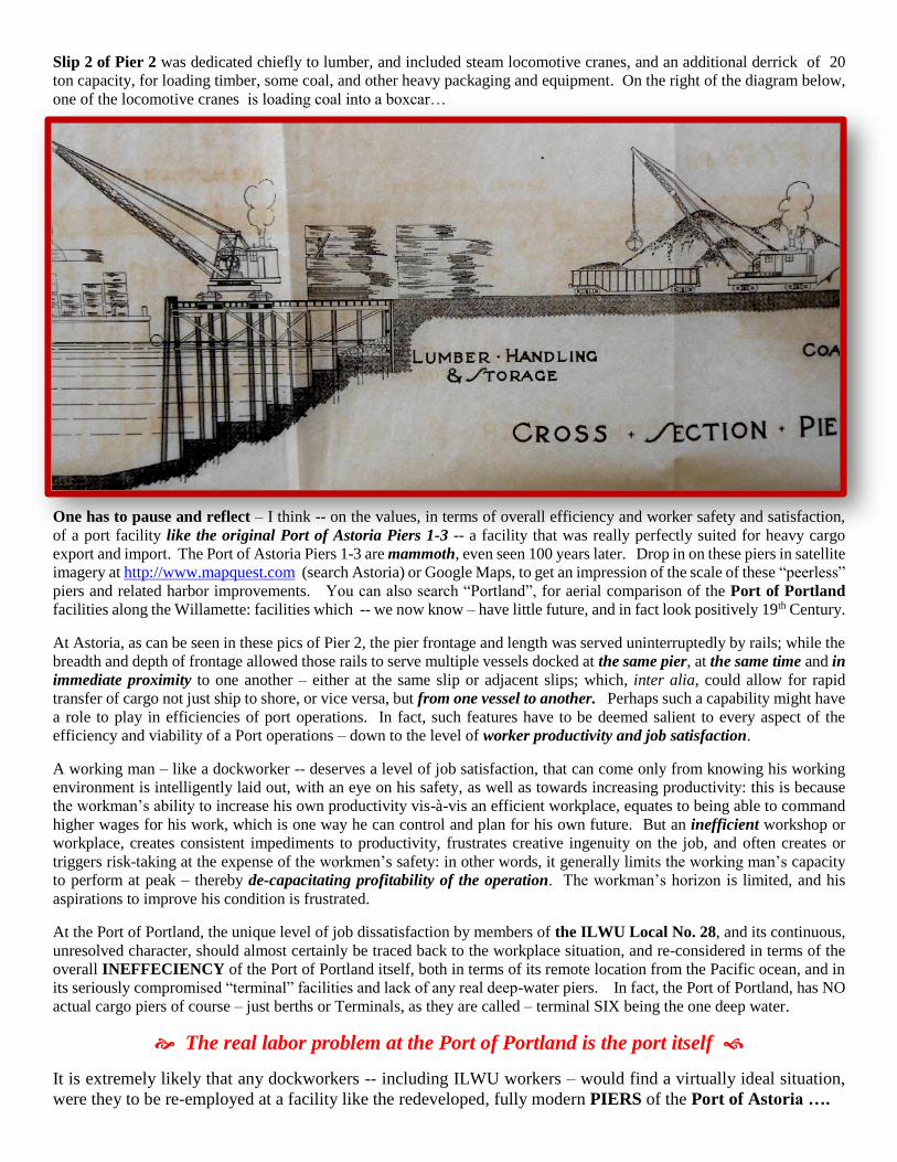
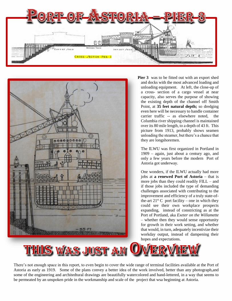
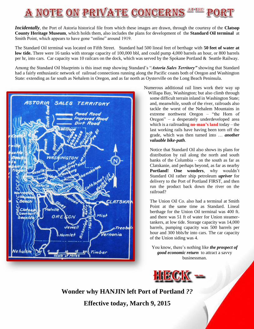
So thatrsquos what Astoria had going for it hellip 100 YEARS AGO
httpwwwsym-zoniacom
Inc