Embed Size (px)
Citation preview
INTERNATIONAL JOURNAL OF SCIENTIFIC & TECHNOLOGY RESEARCH VOLUME 5, ISSUE 06, JUNE 2016 ISSN 2277-8616
278 IJSTR©2016 www.ijstr.org
Analysis Of Influence Of Spatial Planning On Performance Of Regional Development At
Waropen District. Papua, Indonesia
Suwandi, Yohanis Robbi Duwiri
Abstract: The various problems in regional spatial planning in Waropen District, Papua, shows that the Spatial Planning (RTRW) of Waropen District, Papua, drafted in 2010 has not had a positive contribution to the settlement of spatial planning problems. This is most likely caused by the inconsistency in the spatial planning. This study tried to observe the consistency of spatial planning as well as its relation to the regional development performance. The method used to observe the consistency of the preparation of guided Spatial Planning (RTRW) is the analysis of comparative table followed by analysis of verbal logic. In order to determine if the preparation of Spatial Planning (RTRW) has already paid attention on the synergy with the surrounding regions (Inter-Regional Context), a map overlay was conducted, followed by analysis of verbal logic. To determine the performance of the regional development, a Principal Components Analysis (PCA) was done. The analysis results showed that inconsistencies in the spatial planning had caused a variety of problems that resulted in decreased performance of the regional development. The main problems that should receive more attention are: infrastructure, development growth, economic growth, transportation aspect and new properties. Keywords: Spatial planning, development performance
————————————————————
1. INTRODUCTION The regional development should be performed through a more integrated and focused spatial planning, it is necessary so that the limited resources can be utilized effectively and efficiently. One effort to achieve it is through integrated and harmonious development within the well planned space dimension. It is therefore the proper spatial planning is required, either in the planning, utilization and controlling process towards the spatial utilization as a single integrated system, and it should be implemented in an integrated, synergistic and sustainable manner (Budiharjo, 1995). Spatial planning is the process of developing the plan for specific regional space which covers an administrative / governmental area (such as province, district and city) and or functional areas/regions (such as the Watershed areas (DAS), protected areas, urban areas and rural areas) that is reflected in the Spatial Planning (RTRW) documents. Spatial utilization is an operational form of of spatial planning through land use. While the controlling of spatial utilization is reflected within the spatial utilization management documents that regulate the supervision and control mechanism of spatial utilization based on the licensing mechanism, provision of incentives and disincentives, providing compensation, reporting mechanism, monitoring mechanism, evaluation mechanism as well as sanctions imposition mechanism (Budiharjo, 1997; Yunus, 2005).
The various problems of spatial planning in Waropen District, Papua, showed that the Spatial Planning (RTRW) of Waropen District, Papua, that was developed (drafted) in 2010 has not had a positive contribution to the settlement (completion) of spatial planning. This is most likely caused by the inconsistency in the spatial planning. This study tried to observe the consistency of spatial planning as well as its relation to the regional development performance.
2. LITERATURE REVIEW
Development policy The Development policy is closely related to the governmental functions in a particular country or region as well as to the interests of the people (public) of the country or region. The development policy itself is a public policy that embodies all interests and concerns of the public. The Public policy is not only related to the decisions issued by the government, it is also a power that relates the country and its people (Dunn, 1998). Where in fact the government is not the only party whose role is as the originator and decision maker of the policies and their consequences, but there are also other relevant parties involved in the process of defining (decision making) a policy such as the public, private, specific groups of people, and others. (Anwar, 2005)
Spatial Space is an important element within human life which availability is limited. The space itself can be divided into space on land, sea, air space and space inside the earth (Act No. 26 of 2007). The space is said to be an important element because it is the container / ground of all activities and interests performed by humans (Wegener, 2001). On the other hand the activities undertaken by humans are highly diverse which are likely to cause a conflict of interest and may cause damages to the environment (Muchsin, 2008). Therefore, in order to avoid it a spatial planning activity is required to accommodate all of the activities and interests without causing negative (adverse) impacts (Kusumaatmadja, 2003; Soerjani, 1997).
_____________________
Suwandi, Yohanis Robbi Duwiri
Head of Study Program of Regional and Urban Planning of Post Graduate of Cendrawasih University, Jayapura, Papua
Student of Study Program of Regional and Urban Planning of Post Graduate of Cendrawasih University, Jayapura, Papua
INTERNATIONAL JOURNAL OF SCIENTIFIC & TECHNOLOGY RESEARCH VOLUME 5, ISSUE 06, JUNE 2016 ISSN 2277-8616
279 IJSTR©2016 www.ijstr.org
Development Imbalance (disparity) According to Anwar (2005), several factors that led to disparities between regions are: 1) The difference in the characteristics of natural resources abundance (resources endowment); 2) Difference in demographics; 3) Difference in the ability of human resources (human capital); 4) Difference in potential locations; 5) Difference in the aspects of accessibility and power in decision-making; and 6) Difference on the potential market aspect. The above factors caused the differences in the regional characteristics is reviewed by the development aspect, namely: 1) Developed region; 2) Developing region; 3) Underdeveloped region; and 4) Undeveloped region. Advanced/developed region is a region that has properly developed, it is usually characterized as a center of development (growth). Within this region there is a concentration of population, industry, government, as well as the potential market (Sastrowiharjo and Napitupulu, 2001; Reuben, Sebego and Gwebu, 2013). Another feature is the high level of income, high level of education and quality of human resources and also economic structure that is relatively dominated by the industrial sector, services and commercial. The developing region is characterized by rapid growth and is usually becoming buffer areas of the developed region since it has a very good accessibility towards the developed region. Underdeveloped region is characterized by the growth rate which is still low, both in absolute and relative terms, however it has potential natural resources that have not been properly managed nor utilized. The area is inhabited by the low density population with also relatively low level of education. Undeveloped region is characterized by two things, namely: 1) the region does not have potential both natural resources nor location which makes the region naturally difficult to develop as well as to grow; 2) the region actually has the potential, either natural resources or location, or it has both of them.
3. METHODOLOGY The method used to observe the consistency of the preparation (development) of the guided Spatial Planning (RTRW) is by using comparative table analysis followed by analysis of verbal logic. In order to determine if the preparation of Spatial Planning (RTRW) has already paid
attention on the synergy with the surrounding regions (Inter-Regional Context), a map overlay was conducted, followed by analysis of verbal logic. To determine the performance of the regional development, a Principal Components Analysis (PCA) was performed. The variables studied were the infrastructure aspect, facilities aspect, meeting the housing needs aspect, development growth aspect, economic growth aspect, transportation aspect and new property projects. This study involved 66 respondents in total who came from various backgrounds in Waropen District. The data was analyzed using MINITAB software version 16. Furthermore, in order to determine the consistency relationship between regional spatial planning problems and development performance, a verbal logic analysis was used.
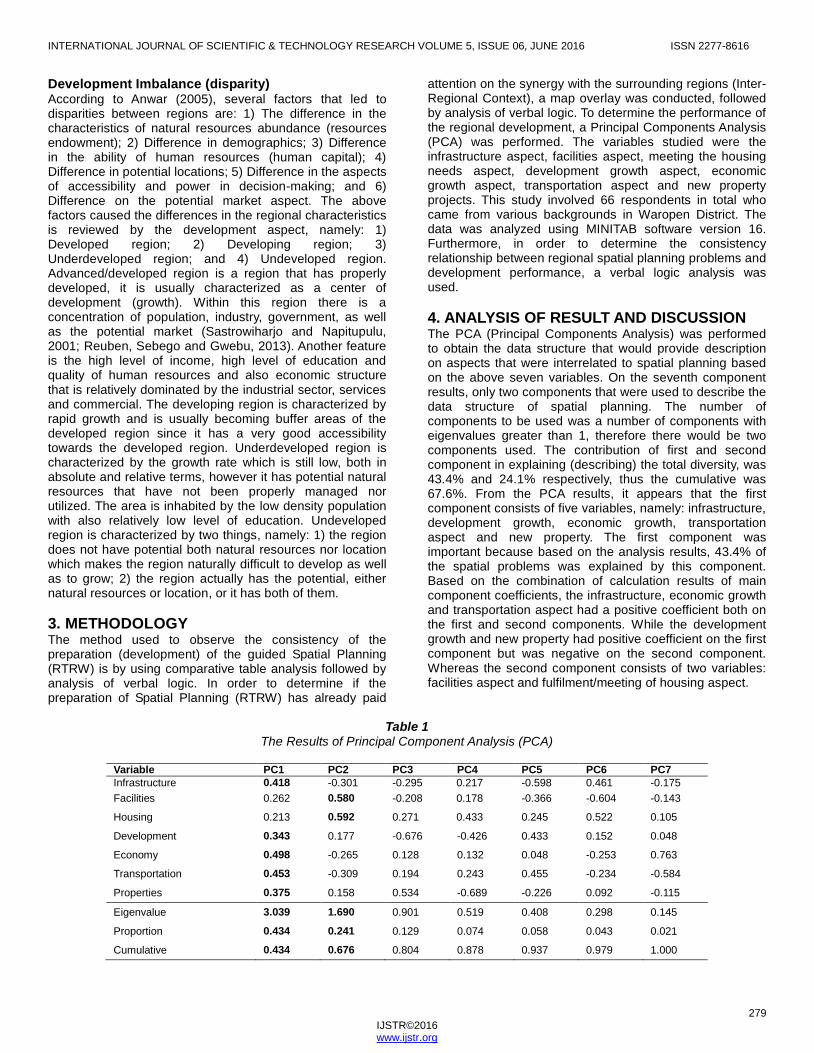
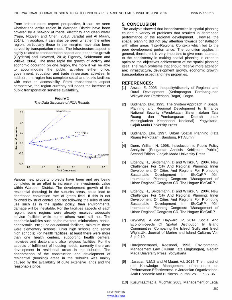
4. ANALYSIS OF RESULT AND DISCUSSION The PCA (Principal Components Analysis) was performed to obtain the data structure that would provide description on aspects that were interrelated to spatial planning based on the above seven variables. On the seventh component results, only two components that were used to describe the data structure of spatial planning. The number of components to be used was a number of components with eigenvalues greater than 1, therefore there would be two components used. The contribution of first and second component in explaining (describing) the total diversity, was 43.4% and 24.1% respectively, thus the cumulative was 67.6%. From the PCA results, it appears that the first component consists of five variables, namely: infrastructure, development growth, economic growth, transportation aspect and new property. The first component was important because based on the analysis results, 43.4% of the spatial problems was explained by this component. Based on the combination of calculation results of main component coefficients, the infrastructure, economic growth and transportation aspect had a positive coefficient both on the first and second components. While the development growth and new property had positive coefficient on the first component but was negative on the second component. Whereas the second component consists of two variables: facilities aspect and fulfilment/meeting of housing aspect.
Table 1
The Results of Principal Component Analysis (PCA)
Variable PC1 PC2 PC3 PC4 PC5 PC6 PC7
Infrastructure 0.418 -0.301 -0.295 0.217 -0.598 0.461 -0.175
Facilities 0.262 0.580 -0.208 0.178 -0.366 -0.604 -0.143
Housing 0.213 0.592 0.271 0.433 0.245 0.522 0.105
Development 0.343 0.177 -0.676 -0.426 0.433 0.152 0.048
Economy 0.498 -0.265 0.128 0.132 0.048 -0.253 0.763
Transportation 0.453 -0.309 0.194 0.243 0.455 -0.234 -0.584
Properties 0.375 0.158 0.534 -0.689 -0.226 0.092 -0.115
Eigenvalue 3.039 1.690 0.901 0.519 0.408 0.298 0.145
Proportion 0.434 0.241 0.129 0.074 0.058 0.043 0.021
Cumulative 0.434 0.676 0.804 0.878 0.937 0.979 1.000
INTERNATIONAL JOURNAL OF SCIENTIFIC & TECHNOLOGY RESEARCH VOLUME 5, ISSUE 06, JUNE 2016 ISSN 2277-8616
280 IJSTR©2016 www.ijstr.org
From infrastructure aspect perspective, it can be seen whether the entire region in Waropen District have been covered by a network of roads, electricity and clean water (Yapa, Nguyen and Chen, 2013; Jaradat and Al Maani, 2014). In addition, it can also be seen whether the entire region, particularly those in the margins have also been served by transportation mode. The infrastructure aspect is highly related to transportation aspect and economic growth (Grydehøj and Hayward, 2014; Elgendy, Seidemann and Wilske, 2004). The more rapid the growth of activity and economic occurring on one region, the more it will be able to accommodate the public activities either office, government, education and trade in services activities. In addition, the region has complete social and public facilities with ease on accessibility. From transportation aspect perspective, the region currently still needs the increase of public transportation services availability.
Figure 1
The Data Structure of PCA Results
Various new property projects have been and are being completed in an effort to increase the investments value within Waropen District. The development growth of the residential (housing) in the suburbs areas, could lead to decreased conversion rate of green field. If this is not followed by strict control and not following the rules of land use such as in the spatial policy, then environmental damage will be inevitable. For the facilities aspects of each region, some regions were already received adequate service facilities while some others were still not. The economic facilities such as the markets, minimarkets, banks, shops/stalls, etc.; For educational facilities, minimum there were elementary schools, junior high schools and senior high schools; For health facilities, at least there were more than one health centers, supporting health centers, midwives and doctors and also religious facilities. For the aspects of fulfillment of housing needs, currently there are development in residential areas in the suburbs. The phenomenon of the construction and development of residential (housing) areas in the suburbs was mainly caused by the availability of quite extensive lands and the reasonable price.
5. CONCLUSION The analysis showed that inconsistencies in spatial planning caused a variety of problems that resulted in decreased performance of the regional development. Likewise, the spatial planning did not pay attention towards constallation with other areas (Inter-Regional Context) which led to the poor development performance. The condition applies in general, therefore it is very important to give more attention to the consistency in making spatial planning in order to optimize the objectives achievement of the spatial planning itself. The main problems that should receive more attention are: infrastructure, development growth, economic growth, transportation aspect and new properties.
REFERENCES: [1] Anwar, E. 2005. Inequality/disparity of Regional and
Rural Development (Ketimpangan Pembangunan Wilayah dan Perdesaan. Bogor). Bogor.
[2] Budiharjo, Eko. 1995. The System Approach in Spatial
Planning and Regional Development to Enhance National Security (Pendekatan Sistem dalam Tata Ruang dan Pembangunan Daerah untuk Meningkatkan Ketahanan Nasional). Yogyakarta. Gajah Mada University Press
. [3] Budiharjo, Eko. 1997. Urban Spatial Planning (Tata
Ruang Perkotaan). Bandung. PT Alumni . [4] Dunn, William N. 1998. Introduction to Public Policy
Analysis: (Pengantar Analisis Kebijakan Publik:) Second Edition. Gadjah Mada University Press
[5] Elgendy, H., Seidemann, D and Wilske, S. 2004. New
Challenges For City And Regional Planning: Inner Development Of Cities And Regions For Promoting Sustainable Development In: ISoCaRP 40th International Planning Congress: “Management of Urban Regions” Congress CD. The Hague: ISoCaRP.
[6] Elgendy, H., Seidemann, D and Wilske, S. 2004. New
Challenges For City And Regional Planning: Inner Development Of Cities And Regions For Promoting Sustainable Development In: ISoCaRP 40th International Planning Congress: “Management of Urban Regions” Congress CD. The Hague: ISoCaRP.
[7] Grydehøj, A dan Hayward, P. 2014. Social And
Economiceects Of Spatial Distribution In Island Communities: Comparing the Islesof Scilly and Isleof Wight,UK. Journal of Marine and Island Cultures Vol. 3, p.9-19.
[8] Hardjosoemantri, Koesnadi, 1993, Environmental
Management Law (Hukum Tata Lingkungan), Gadjah Mada University Press. Yogyakarta
[9] .Jaradat, N.M.S and Al Maani, A.I. 2014. The impact of
the Knowledge Management Infrastructure on Performance Effectiveness in Jordanian Organizations. Arab Economic And Business Journal Vol. 9, p.27-36
[10] Kusumaatmadja, Muchtar. 2003, Management of Legal
INTERNATIONAL JOURNAL OF SCIENTIFIC & TECHNOLOGY RESEARCH VOLUME 5, ISSUE 06, JUNE 2016 ISSN 2277-8616
281 IJSTR©2016 www.ijstr.org
Issues of the Human Environment: Thoughts and Suggestions (Pengaturan Hukum Masalah Lingkungan Hidup Manusia: Beberapa Pikiran dan Saran). Ninth Edition, Binacipta. Bandung.
[11] Muchsin, Imam Koeswahyono, 2008, Legal Policy
Aspect of Land Use and Spatial Planning (Aspek Kebijaksanaan Hukum Penatagunaan Tanah Dan Penataan Ruang), First Edition. Sinar Grafika. Jakarta
[12] Reuben J, Sebego, R.J dan Gwebu, T.D. 2013.
Patterns, determinants, impacts and policy implications of the spatial expansion of an African capital city. International Journal of Sustainable Built Environment Vol. 2, p.193-208.
[13] Sastrowihardjo, M. and Napitupulu, H. 2001. Land
Policy and Effectiveness Study on Spatial Plan in Directing Infrastructure Development. Case Studies of the Roads and Drainage in the Semarang city (Kebijakan Pertanahan dan Studi Efektivitas Rencana Tata Ruang Dalam Mengarahkan Pembangunan Infrastruktur. Studi Kasus Jalan dan Drainase di Kota Semarang). 2007. Pusat Studi Pertanahan dan Tata Ruang (TAHTA) research institute - Diponegoro University.
[14] Soerjani, Mohamad. 1997, Development and the
Environment: Pursuing Ideas and Implementation of Sustainable Development (Pembangunan dan Lingkungan: Meniti Gagasan dan Pelaksanaan Sustainable Development). IPPL, Jakarta
[15] Law No. 32 of 2004 regarding Regional Government [16] Law No. 32 of 2009 regarding Environmental
Management [17] Law No. 26 of 2007 regarding Spatial Planning [18] Wegener, M. 2001. New Spatial Planning Models. JAG
Vol. 3 issue 3. [19] Yapa, M. B., Nguyen, H.O. and Chen, S.L. 2013.
Determinants of Port Infrastructure Pricing. The Asian Journal of Shipping and Logistics. Volume 29, No. 2, p. 187-206.
[20] Yunus. H. S. (2005) Management of city: Spatial
Perspective (Manajemen kota: Prespektif spasial). Pustaka Pelajar. Yogyakarta.