Embed Size (px)
Citation preview

Plate tectonicsEarthquakes and Volcanoes

Changing face of the world

Theory of Continental Drift• Given by Alfred Wegner in 1912• Believed that world was once only one piece of land
called the Pangaea which broke up into Gondwanaland and Laurasia and the Tethys sea
• Evidence of Pangaea▫ Biology: Remains of Mesosauras have been found in South Africa
and Brazil▫ Geology: Similar rock type of Appalachians and mountains of
north-west Europe▫ Climatology: Coal, sandstone and limestone could not been
formed in Britain with its present climate
What is Plate tectonics?
• It is the science which studies the movement of plates
• These plates are either continental or oceanic• There are 7 large and several smaller plates• They are constantly in motion- move at a speed
of the growth of our nails.• These plates move like a conveyor belt due to the
convection currents.

Distribution of various plates


Interior structure of Earth

LAYERS OF EARTH• CRUST
▫ Oceanic crust is about 6-10km thick and is mainly formed of basalt▫ Continental crust is up to 70 km thick
• MANTLE▫ Mainly composed of silicate rocks rich in iron and magnesium. The
upper mantle is rigid whereas the lower mantle is semi-liquid known as asthenosphere.
▫ Crust and upper mantle together are known as Lithosphere.• CORE
▫ About 6371 Km deep▫ Made up of mainly iron and Nickel▫ Is the size of Mars▫ Outer core is semi-molten and inner core is solid▫ Hotter than surface of the sun (about 6200 C)

Types of Lithospheric Plates
• There are two types▫ Continental Plate
35-40km thick; about 60 km thick under the mountains
The rocks are about 1500 million years old Rocks are mainly composed of silica and aluminum,
granite is the most common Also known as SIAL

Contd:
• Oceanic Plate▫ 6-10 km thick▫ The rocks are about 200 million years old▫ Higher density than continental crust▫ Generally contains Silica and Magnesium; mainly
basalt▫ Also known as SIMA

Different types of plate boundaries

Types of Plate Boundaries• Constructive or Divergent
▫ Two plates moving away from each other▫ New oceanic crust appears▫ Forms mid ocean ridges and volcanoes▫ E.g. Mid Atlantic Ridge
• Destructive or Convergent▫ Two plates moving towards each other- one oceanic
and one continental▫ Oceanic being heavier sinks▫ Forms deep sea trenches and island arcs▫ Andes; Rockies Island arcs of West Indies

CONTD:• Collision zones
▫ Two continental plates collide▫ As neither can sink, forms Fold mountains▫ E.g. Himalayas and Alps
• Conservative or passive▫ Along the transform Faults▫ Plates brush past each other▫ No land is formed or destroyed▫ E.g. San Andreas Fault in California

Exceptions• Generally the center of the
plates is rigid which forms▫ Shield lands (cratons)-
Canadian or Laurentian shield
▫ Depressions on the edges of the shield from large basins like Mississippi- Missouri, Amazon
There is an exception to this in the form of Hotspots(shield volcanoes)and African rift valley.

Structure of a Volcano


Types of Volcanoes

Volcanic Explosivity Index (VEI)

Types of Faults• Strike-slip faults indicate rocks are sliding past each other
horizontally, with little to no vertical movement. Both the San Andreas and Anatolian Faults are strike-slip.
• Normal faults create space. Two blocks of crust pull apart, stretching the crust into a valley. The Basin and Range Province in North America and the East African Rift Zone are two well-known regions where normal faults are spreading apart Earth's crust.
• Reverse faults, also called thrust faults, slide one block of crust on top of another. These faults are commonly found in collisions zones, where tectonic plates push up mountain ranges such as the Himalayas and the Rocky Mountains.


Volcanic Hazards• PRIMARY
▫ Lava Flows▫ Pyroclastic flows▫ Ash and Tephra
fall▫ Volcanic gases
• SECONDARY▫ Lahars▫ Volcanic landslides▫ Tsunamis

Source:http://pubs.usgs.gov/fs/2000/fs060-00/images/volcano-hazards.jpg

Source: http://science.kqed.org/quest/files/2012/02/INFOGRAPHIC-WITH-TEXT-v5.jpg

Types of Seismic Waves• Body Waves
P Waves The first kind of body wave is the P wave or primary wave This is the
fastest kind of seismic wave. The P wave can move through solid rock and fluids, like water or the liquid layers of the earth. It pushes and pulls the rock it moves through just like sound waves push and pull the air. Have you ever heard a big clap of thunder and heard the windows rattle at the same time? The windows rattle because the sound waves were pushing and pulling on the window glass much like P waves push and pull on rock. Sometimes animals can hear the P waves of an earthquake. Usually we only feel the bump and rattle of these waves.

• S Waves ▫ The second type of body wave is the S wave or
secondary wave , which is the second wave you feel in an earthquake. An S wave is slower than a P wave and can only move through solid rock. This wave moves rock up and down, or side-to-side.

• Surface Waves ▫ Love Waves
• The first kind of surface wave is called a Love wave , named after A.E.H. Love, a British mathematician who worked out the mathematical model for this kind of wave in 1911. It's the fastest surface wave and moves the ground from side-to-side.
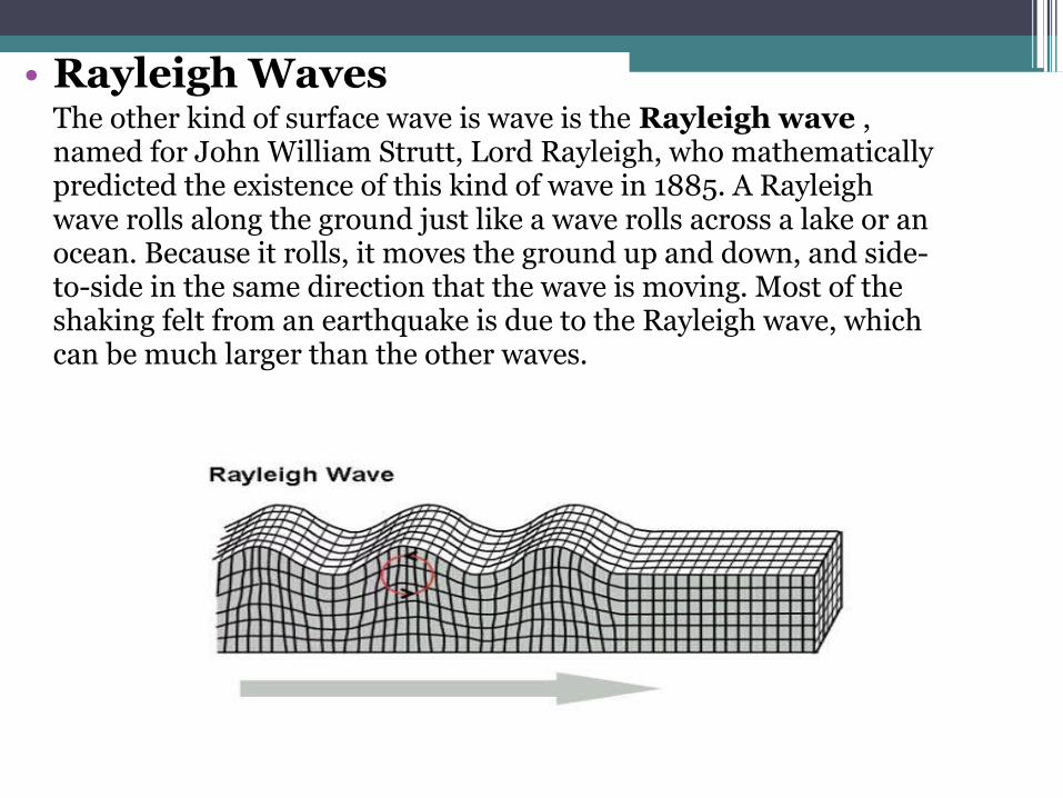
• Rayleigh Waves The other kind of surface wave is wave is the Rayleigh wave , named for John William Strutt, Lord Rayleigh, who mathematically predicted the existence of this kind of wave in 1885. A Rayleigh wave rolls along the ground just like a wave rolls across a lake or an ocean. Because it rolls, it moves the ground up and down, and side-to-side in the same direction that the wave is moving. Most of the shaking felt from an earthquake is due to the Rayleigh wave, which can be much larger than the other waves.

Earthquakes can be: • Shallow: If the focus is near the surface—
between 0 and 70 km (0 and 40 mi) deep—shallow-focus earthquakes are produced.
• Deep: If it is deep below the crust—between 70 and 700 km (40 and 400 mi) deep—a deep-focus earthquake will be produced.
Benioff Zone: Line along the subduction zone
Either TECTONIC or MAGMATIC

Hazards caused by Earthquakes
• PRIMARY▫ Ground movement/shaking
• SECONDARY▫ Soil Liquefaction▫ Landslides/Avalanches▫ Tsunamis▫ Fires▫ Aftershocks
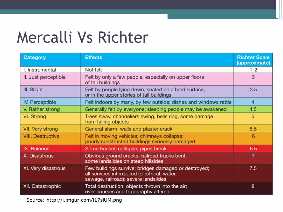
Mercalli Vs Richter
Source: http://i.imgur.com/i17siUM.png
Managing earthquake hazards
• Impact of this hazard depends on:▫ PHYSICAL FACTORS
Location of Epicenter Depth of focus Duration of shaking Time of the day Structure/material of the rocks
▫ HUMAN FACTORS Building style and land use People’s reactions Preparedness of the community Emergency services and relief Economic and social structure for preparedness; education
about the hazard and ability to recover

Predicting earthquakes and VolcanoesNot easy and accurate but :• Use laser beams to detect plate movements• Monitor release of Radon gas• Seismometers• Monitoring the changing shape of a
volcano/ground• Increased frequency of earthquakes indicates an
oncoming eruption

Preparedness
• Important to-• Have regular evacuation drills, including schools• Building which are quake resistant• Pre conceived, Emergency plans

Why do people continue to live in areas prone to hazards?• Fertile soil• Tourism opportunities• Emotional attachment• Cannot move due to financial reasons- no where
else to go- No choice• Government is equipped to cope with the
hazard- people have faith in the administration• Leaving would mean evacuating the entire
country.

Weathering• The disintegration and decomposition of rocks
in situ i.e in its original position due to▫ Exposure to air and water▫ Release of pressure▫ Fluctuation in temperature
As it does not involve movement, it is cannot be equated with erosion!!!
Types of Weathering
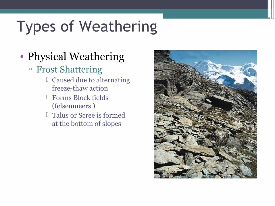
• Physical Weathering▫ Frost Shattering
Caused due to alternating freeze-thaw action
Forms Block fields (felsenmeers )
Talus or Scree is formed at the bottom of slopes

• Salt Crystallization Occurs in deserts and
near coasts Water evaporates leaving
salt crystals behind which lead to the disintegration of rocks

• Pressure release▫ When intrusive igneous rocks are exposed to surface,
the pressure release develops cracks▫ If these are parallel to the surface, sheeting occurs▫ This process is responsible for exfoliation domes

• Thermal Expansion or Insolation weathering▫ High Diurnal range of temperature▫ Generally happens in deserts▫ Outer layers gets heated quicker than inner one- peels off▫ Sometimes the minerals present in rocks can also lead to the rock
peeling

• Biological Weathering▫ Trees growing along the bedding plans or extending
into joints▫ Can also be caused by burrowing

BibliographyIMAGES • www.amonline.net.au/.../earth/volcanism.htm • www.georesources.co.uk/volgen.htm • mediatheek.thinkquest.nl/.../en/fullvolcano.htm • http://vulcan.wr.usgs.gov/Imgs/Gif/PlateTectonics/Maps/map_plate_tectonics_wo
rld.gif• http://www.uwsp.edu/geo/faculty/ritter/images/lithosphere/tectonics/earth_struct
ure.jpg• http://www.geo.brown.edu/People/Grads/abt/Tools/Seismology/SeismoIntro.htm• http://justquikr.com/wp-content/uploads/2013/06/Rift-valley.jpg• http://www.seismolab.caltech.edu/images/gallery/anatomy/image-6.jpg• http://pubs.usgs.gov/fs/fs002-97/images/volcBMeyers.png• http://climateswag.files.wordpress.com/2014/04/6ac18-veitable.jpg?w=500Information1. Codrington, S. (2005) Planet Geography, 3rd edition, Solid Star Press2. Waugh, D. (2002) Geography An Integrated Approach, Nelson Thornes3. Waugh, D. (2003) The New Wider World, 2nd Edition, Nelson Thornes4. Microsoft ® Encarta ® Encyclopedia © 1993-2004 Microsoft Corporation