Embed Size (px)
Citation preview

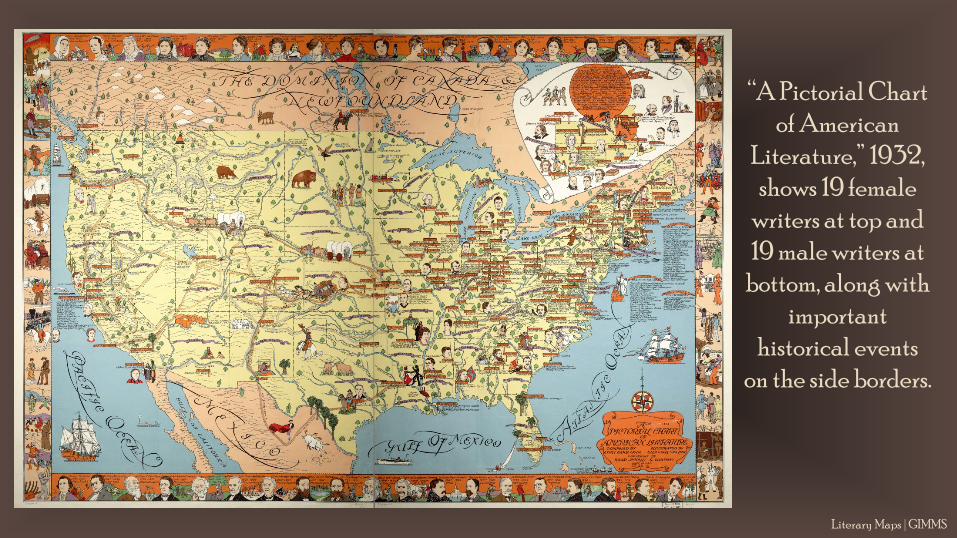
“A Pictorial Chart of American
Literature,” 1932, shows 19 female
writers at top and 19 male writers at
bottom, along with important
historical events on the side borders.
Literary Maps | GIMMS

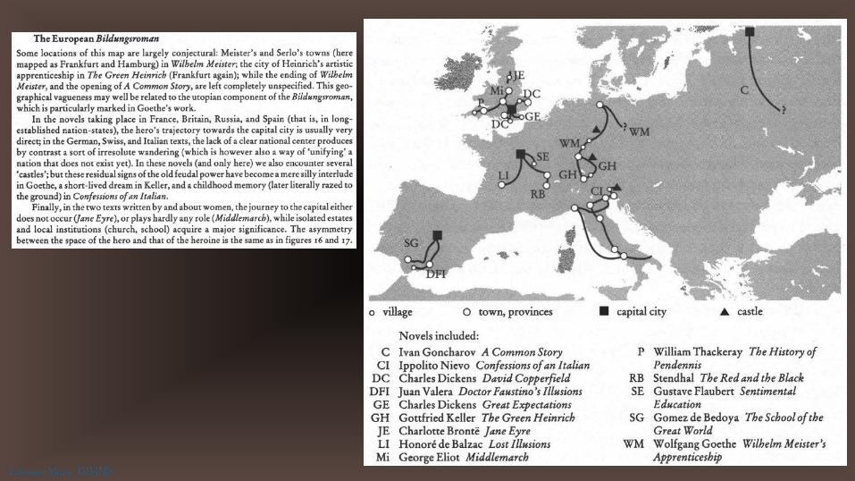
Maps allow us to investigate literature in unique ways, visually situating writers and their works in geography and history.
Literary Maps | GIMMS

This 1933 map places authors and their works across
the nation.
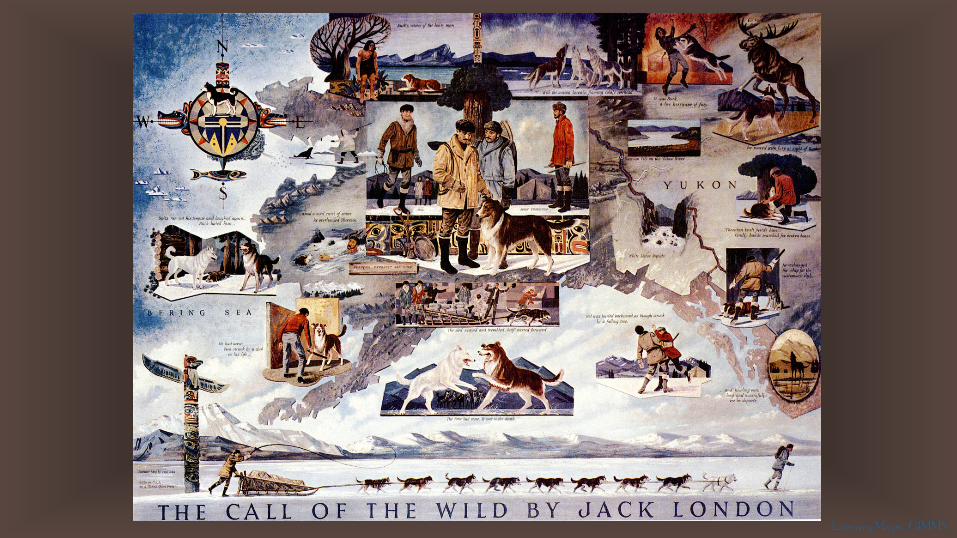
Although not yet a state, Alaska
Territory is prominently
included.
Literary Maps | GIMMS

This inset from the previous map proclaims New England to be “The Birthplace of
American Literature,” pointing out authors’ homes and the settings of various works.
The map helps explain the prominence of seafaring tales in the early period of American
literature, noting Moby Dick and Two Years Before the Mast, as well as regional works
referring to water features, such as Walden Pond and The Deepening Stream.
Literary Maps | GIMMS
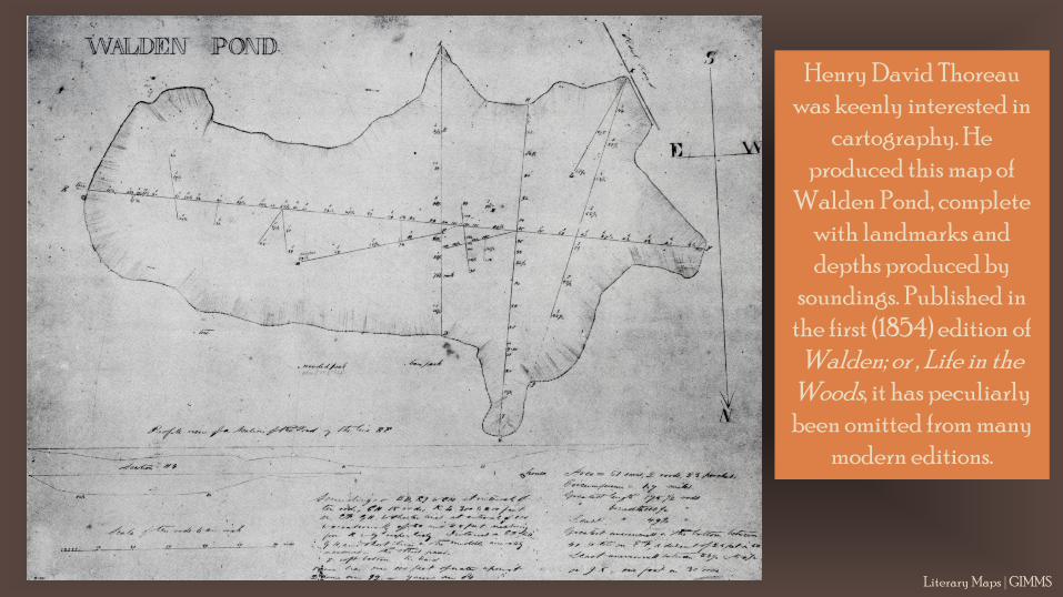
Henry David Thoreau was keenly interested in
cartography. He produced this map of
Walden Pond, complete with landmarks and depths produced by
soundings. Published in the first (1854) edition of
Walden; or , Life in the Woods, it has peculiarly been omitted from many
modern editions.
Literary Maps | GIMMS
Literary Maps | GIMMS
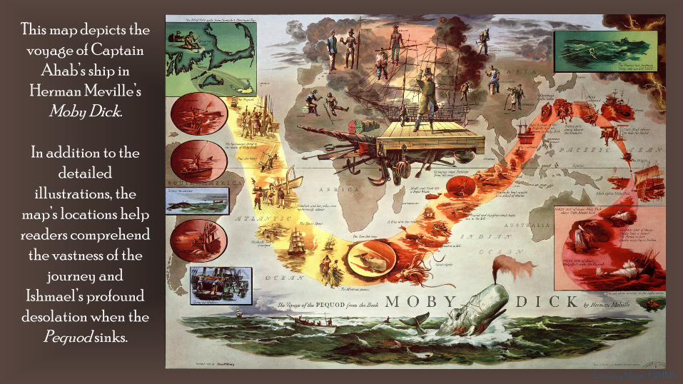
This map depicts the voyage of Captain
Ahab’s ship in Herman Meville’s
Moby Dick.
In addition to the detailed
illustrations, the map’s locations help readers comprehend
the vastness of the journey and
Ishmael’s profound desolation when the
Pequod sinks.

Transatlantic journeys in Henry James’ novels: the author often sends his protagonists from America to Europe, taking them from innocence to experience.
Literary Maps | GIMMS
Literary Maps | GIMMS
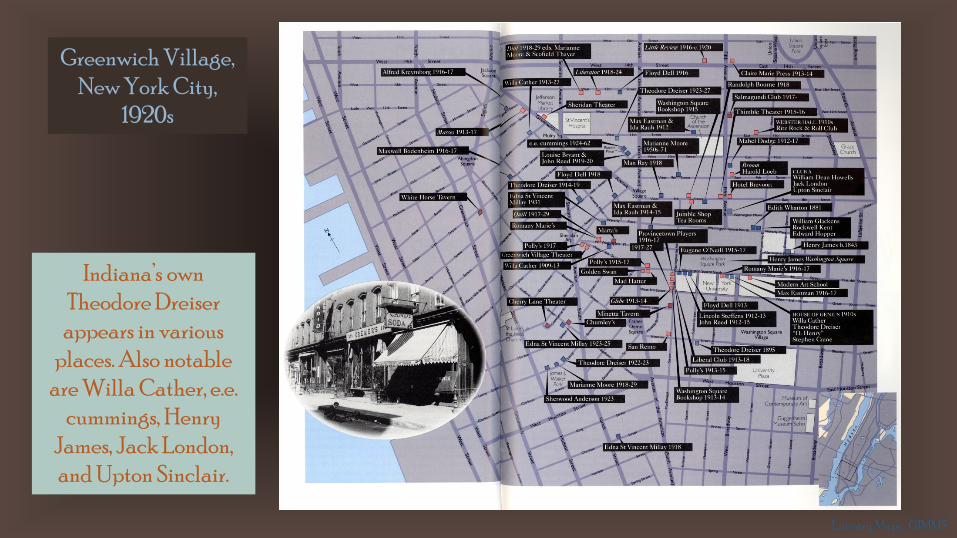
Greenwich Village, New York City,
1920s
Indiana’s own Theodore Dreiser
appears in various places. Also notable
are Willa Cather, e.e. cummings, Henry
James, Jack London, and Upton Sinclair.
Literary Maps | GIMMS
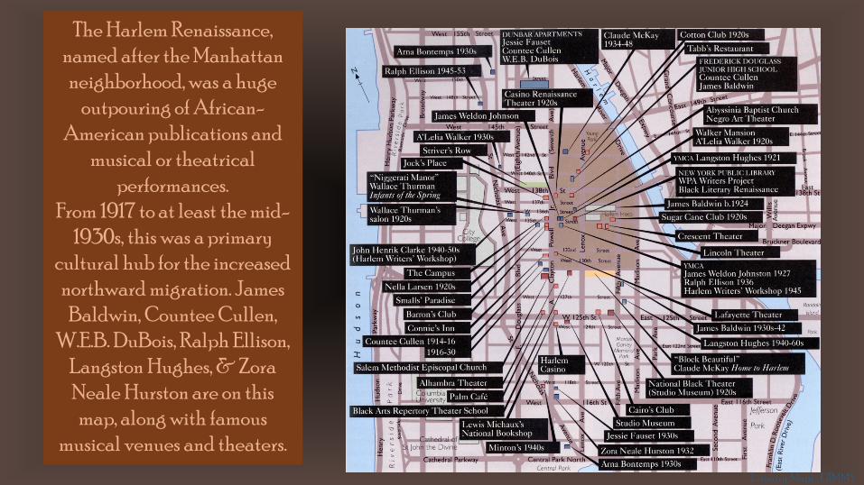
The Harlem Renaissance, named after the Manhattan neighborhood, was a huge
outpouring of African-American publications and
musical or theatrical performances.
From 1917 to at least the mid-1930s, this was a primary
cultural hub for the increased northward migration. James
Baldwin, Countee Cullen, W.E.B. DuBois, Ralph Ellison,
Langston Hughes, & ZoraNeale Hurston are on this map, along with famous
musical venues and theaters.
Literary Maps | GIMMS
Literary Maps | GIMMS
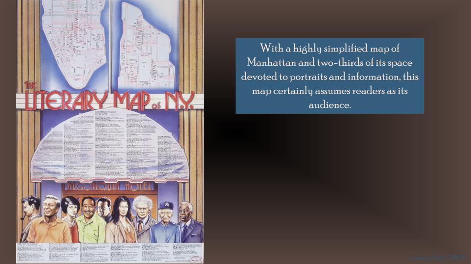
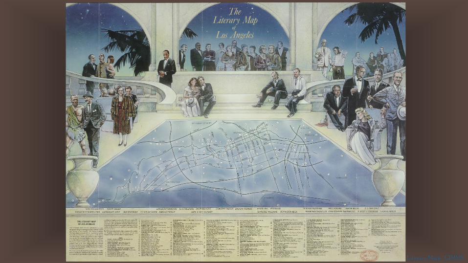
With a highly simplified map of Manhattan and two-thirds of its space
devoted to portraits and information, this map certainly assumes readers as its
audience.
Literary Maps | GIMMS

Literary Maps | GIMMS
Literary Maps | GIMMS
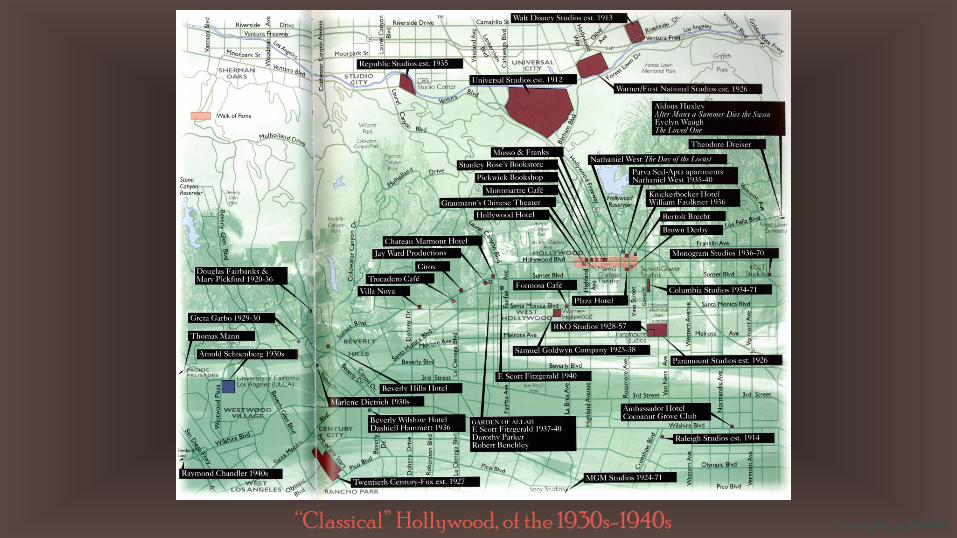
“Classical” Hollywood, of the 1930s-1940s Literary Maps | GIMMS
Literary Maps | GIMMS

Literary San Francisco
This map fills each outlined neighborhood or park with an
associated quote.
Literary Maps | GIMMS
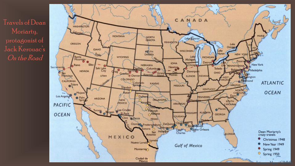
Travels of Dean Moriarty,
protagonist of Jack Kerouac’s
On the Road
Literary Maps | GIMMS
Literary Maps | GIMMS
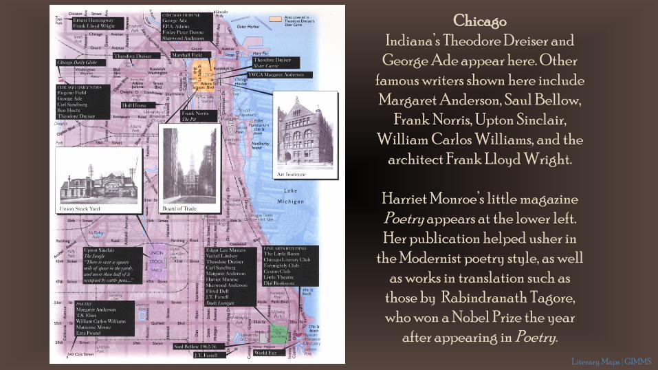
ChicagoIndiana’s Theodore Dreiser and
George Ade appear here. Other famous writers shown here include Margaret Anderson, Saul Bellow,
Frank Norris, Upton Sinclair, William Carlos Williams, and the
architect Frank Lloyd Wright.
Harriet Monroe’s little magazine Poetry appears at the lower left. Her publication helped usher in
the Modernist poetry style, as well as works in translation such as
those by Rabindranath Tagore, who won a Nobel Prize the year
after appearing in Poetry.Literary Maps | GIMMS
Literary Maps | GIMMS
Literary Maps | GIMMS
Literary Maps | GIMMS

Literary Maps | GIMMS
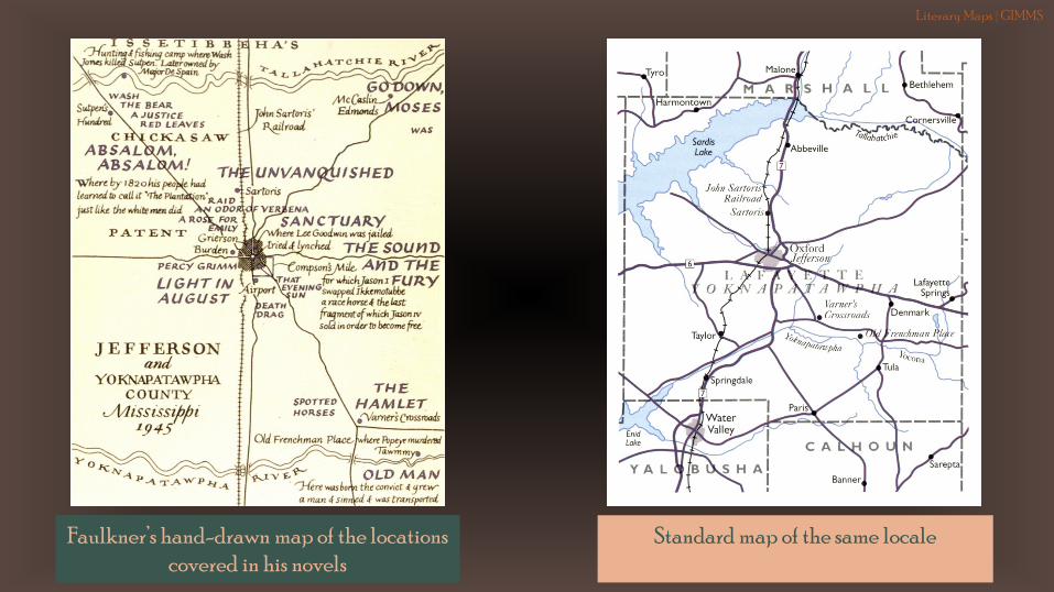
Faulkner’s hand-drawn map of the locations covered in his novels
Standard map of the same locale
Literary Maps | GIMMS
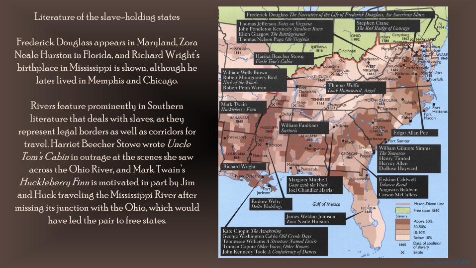
Literature of the slave-holding states
Frederick Douglass appears in Maryland, ZoraNeale Hurston in Florida, and Richard Wright’s birthplace in Mississippi is shown, although he
later lived in Memphis and Chicago.
Rivers feature prominently in Southern literature that deals with slaves, as they
represent legal borders as well as corridors for travel. Harriet Beecher Stowe wrote Uncle
Tom’s Cabin in outrage at the scenes she saw across the Ohio River, and Mark Twain’s
Huckleberry Finn is motivated in part by Jim and Huck traveling the Mississippi River after
missing its junction with the Ohio, which would have led the pair to free states.
Literary Maps | GIMMS
Literary Maps | GIMMS
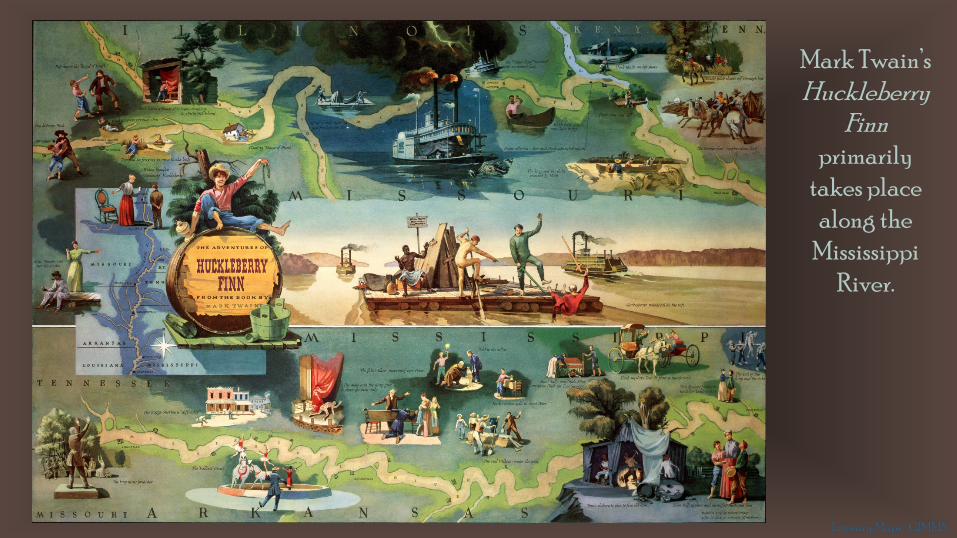
Mark Twain’s Huckleberry
Finn primarily
takes place along the
Mississippi River.

Literary Maps | GIMMS
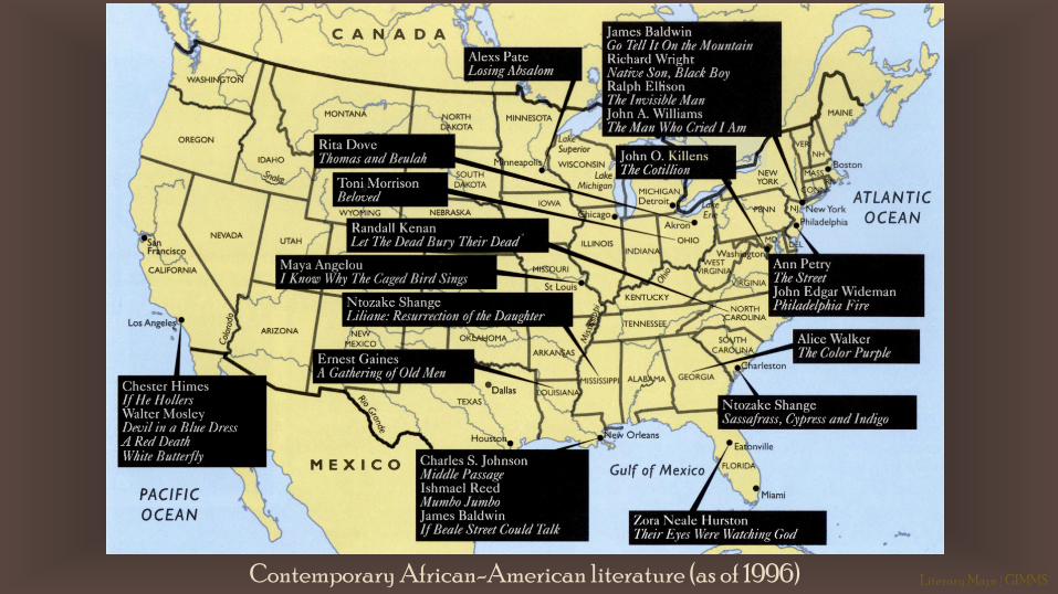
Contemporary African-American literature (as of 1996) Literary Maps | GIMMS

Literary Maps | GIMMS
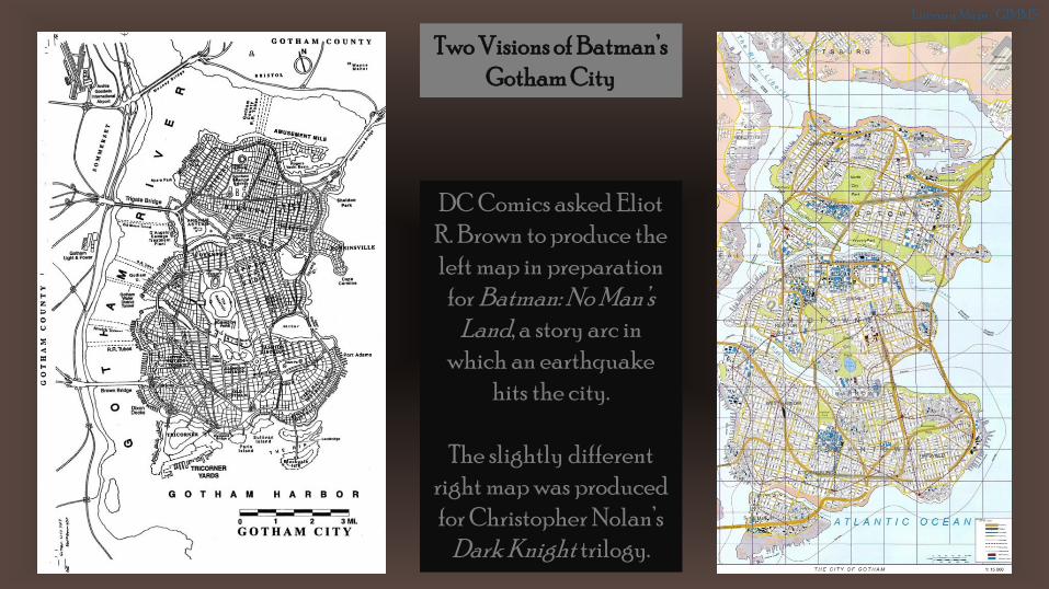
Two Visions of Batman’s Gotham City
Literary Maps | GIMMS
DC Comics asked Eliot R. Brown to produce the left map in preparation
for Batman: No Man’s Land, a story arc in
which an earthquake hits the city.
The slightly different right map was produced for Christopher Nolan’s
Dark Knight trilogy.
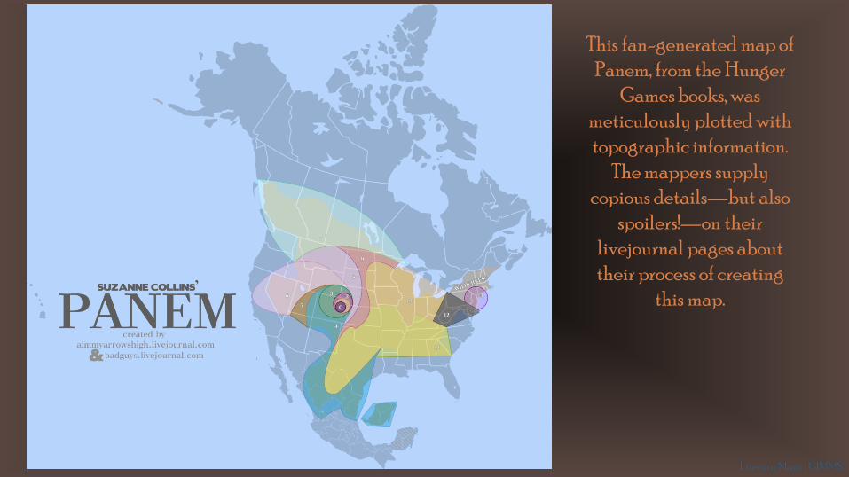
This fan-generated map of Panem, from the Hunger
Games books, was meticulously plotted with topographic information.
The mappers supply copious details—but also
spoilers!—on their livejournal pages about their process of creating
this map.
Literary Maps | GIMMS
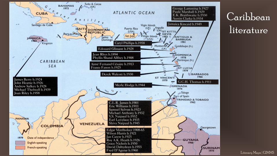
Caribbean literature
Literary Maps | GIMMS
Literary Maps | GIMMS
Literary Maps | GIMMS
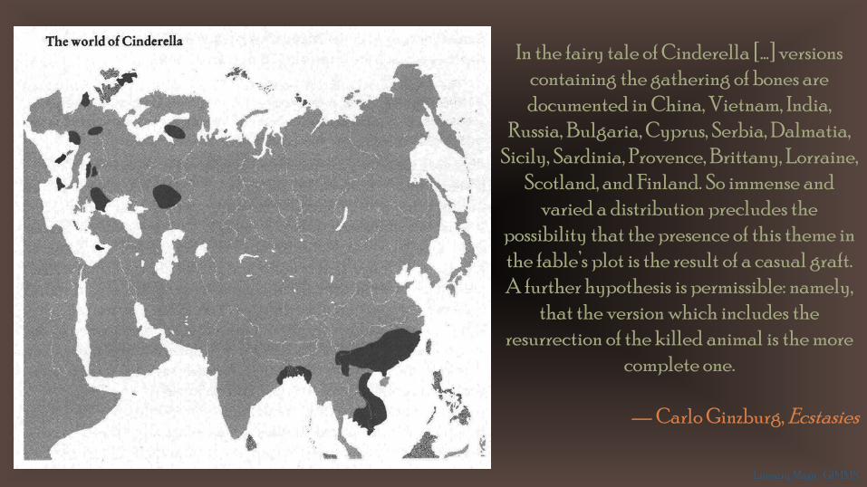
In the fairy tale of Cinderella […] versions containing the gathering of bones are documented in China, Vietnam, India,
Russia, Bulgaria, Cyprus, Serbia, Dalmatia, Sicily, Sardinia, Provence, Brittany, Lorraine,
Scotland, and Finland. So immense and varied a distribution precludes the
possibility that the presence of this theme in the fable’s plot is the result of a casual graft. A further hypothesis is permissible: namely,
that the version which includes the resurrection of the killed animal is the more
complete one.
— Carlo Ginzburg, Ecstasies
Literary Maps | GIMMS

Literary Maps | GIMMS
Literary Maps | GIMMS
Literary Maps | GIMMS

Washington Irving’s travels in Europe
Literary Maps | GIMMS

Literary Maps | GIMMS
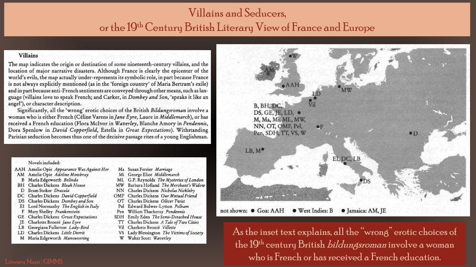
As the inset text explains, all the “wrong” erotic choices of the 19th century British bildungsroman involve a woman
who is French or has received a French education.
Villains and Seducers, or the 19th Century British Literary View of France and Europe
Literary Maps | GIMMS
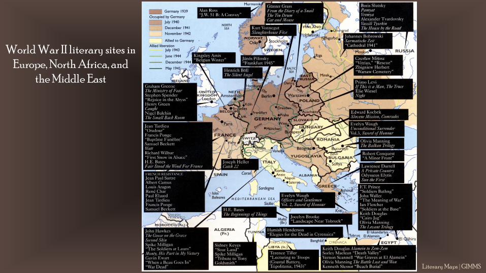
World War II literary sites in Europe, North Africa, and
the Middle East
Literary Maps | GIMMS

Literature of World War II set
in the Pacific
Literary Maps | GIMMS

Map of a walk around Tintagel, a site long associated with King Arthur’s castle Literary Maps | GIMMS

Literary Maps | GIMMS
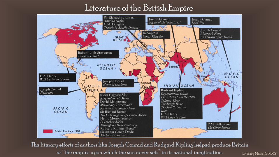
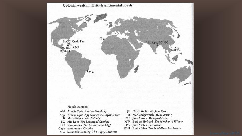
The literary efforts of authors like Joseph Conrad and Rudyard Kipling helped produce Britain as “the empire upon which the sun never sets” in its national imagination.
Literature of the British Empire
Literary Maps | GIMMS
Literary Maps | GIMMS
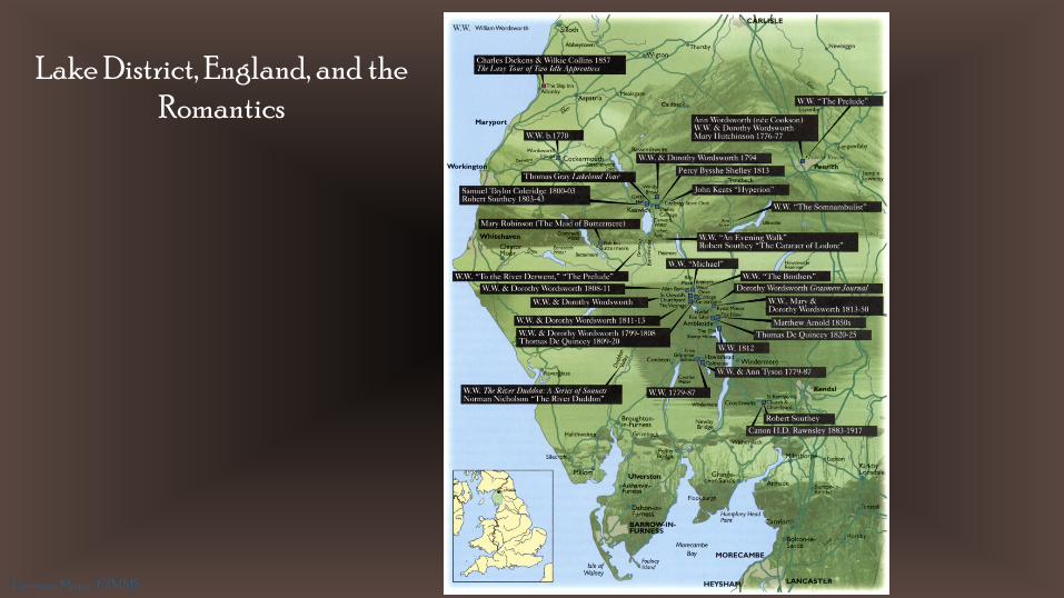
Lake District, England, and the Romantics
Literary Maps | GIMMS
Literary Maps | GIMMS
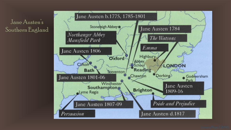
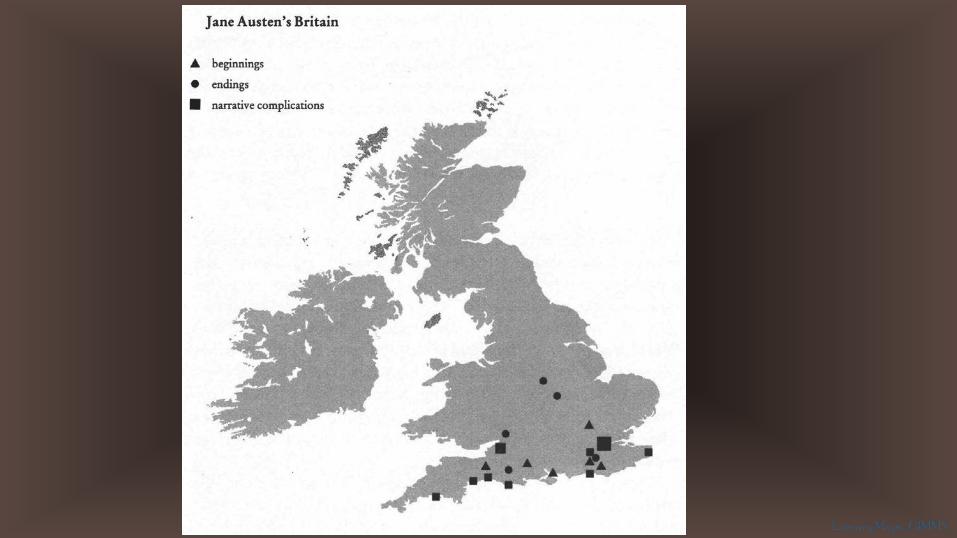
Jane Austen’s Southern England
Literary Maps | GIMMS
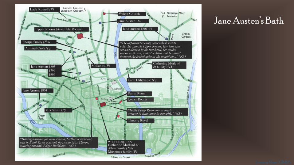
Jane Austen’s Bath
Literary Maps | GIMMS
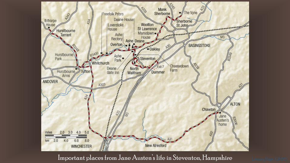
Important places from Jane Austen’s life in Steventon, Hampshire Literary Maps | GIMMS

Walking tour of Jane Austen’s Bath Literary Maps | GIMMS
Literary Maps | GIMMS

Charles Dickens’ London
Literary Maps | GIMMS

Sherlock Holmes’ London Unlike Doyle’s first two novels, which take place mostly south of the Thames, the short stories from 1891 onwards mostly focus on
the West End and the City. The short stories were far more immediately popular
than the novels. Holmes’ success may be due to the shift in location to what the
public saw as the “right” space for detectives.
Literary Maps | GIMMS
Literary Maps | GIMMS
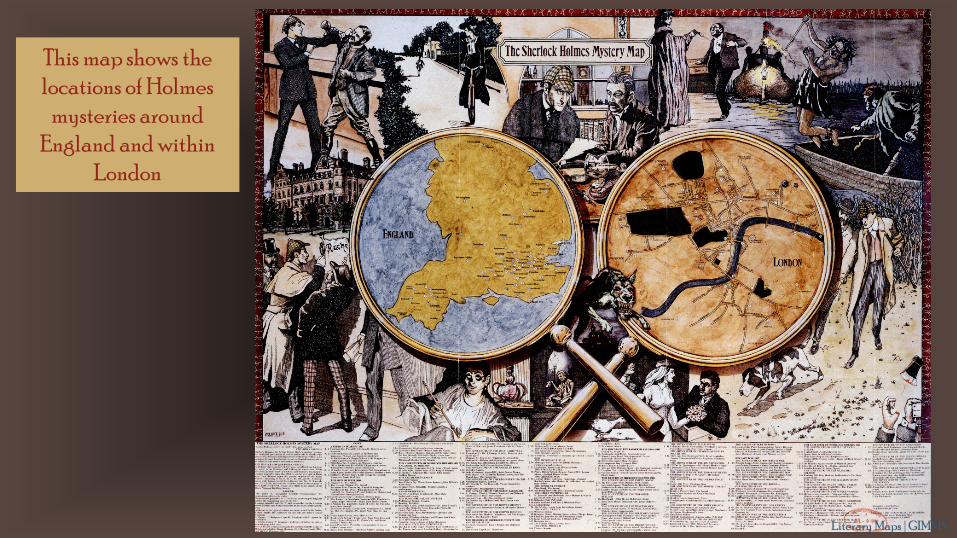
This map shows the locations of Holmes
mysteries around England and within
London
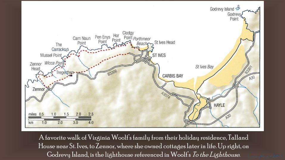
A favorite walk of Virginia Woolf’s family from their holiday residence, TallandHouse near St. Ives, to Zennor, where she owned cottages later in life. Up right, on
Godrevy Island, is the lighthouse referenced in Woolf’s To the Lighthouse. Literary Maps | GIMMS
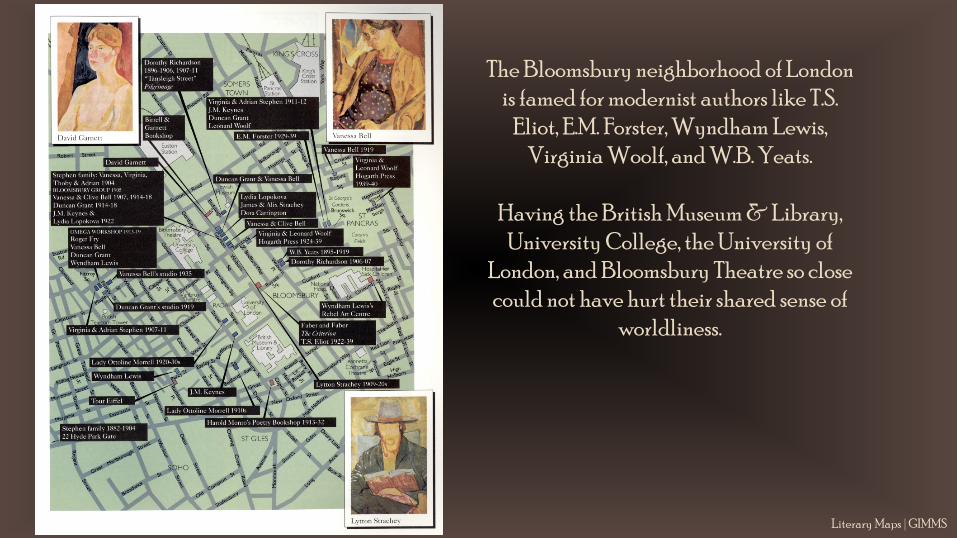
The Bloomsbury neighborhood of London is famed for modernist authors like T.S.
Eliot, E.M. Forster, Wyndham Lewis, Virginia Woolf, and W.B. Yeats.
Having the British Museum & Library, University College, the University of
London, and Bloomsbury Theatre so close could not have hurt their shared sense of
worldliness.
Literary Maps | GIMMS
Literary Maps | GIMMS
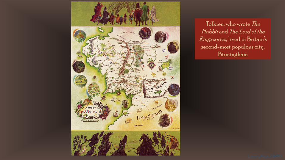
Tolkien, who wrote The Hobbit and The Lord of the
Rings series, lived in Britain’s second-most populous city,
Birmingham
Literary Maps | GIMMS
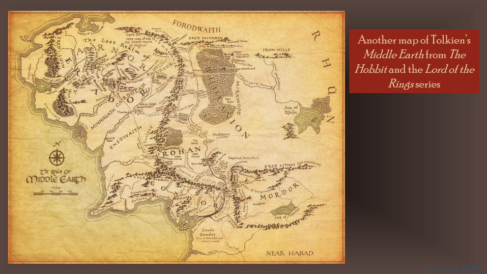
Another map of Tolkien’s Middle Earth from The
Hobbit and the Lord of the Rings series
Literary Maps | GIMMS
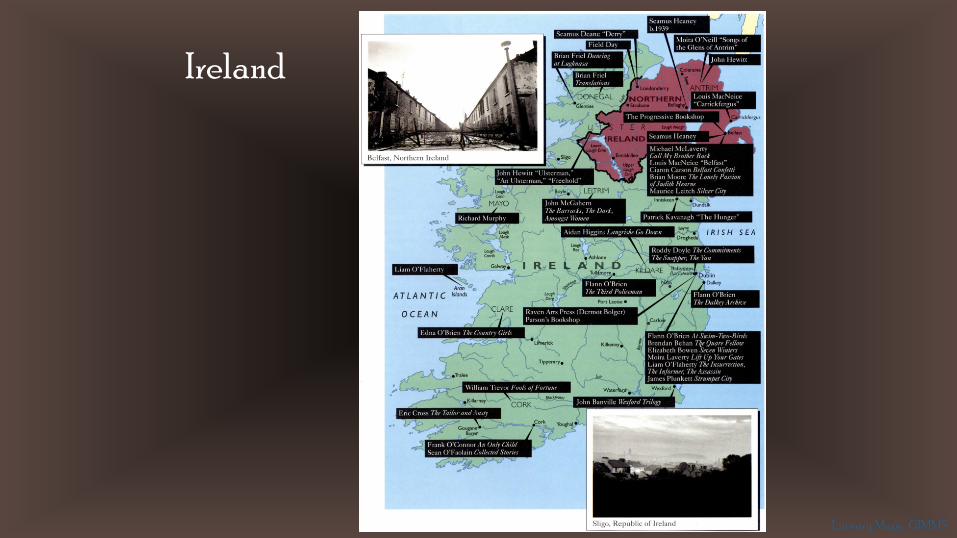
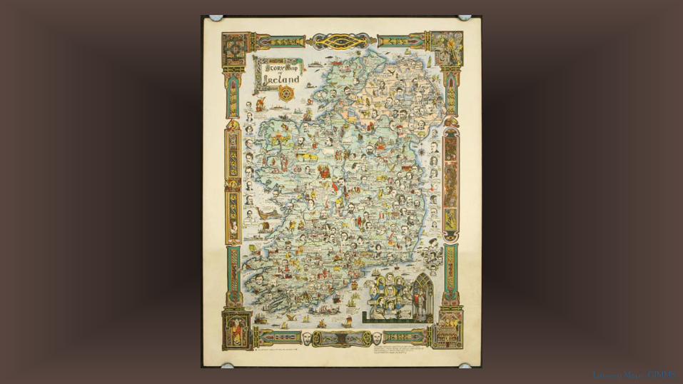
Ireland
Literary Maps | GIMMS
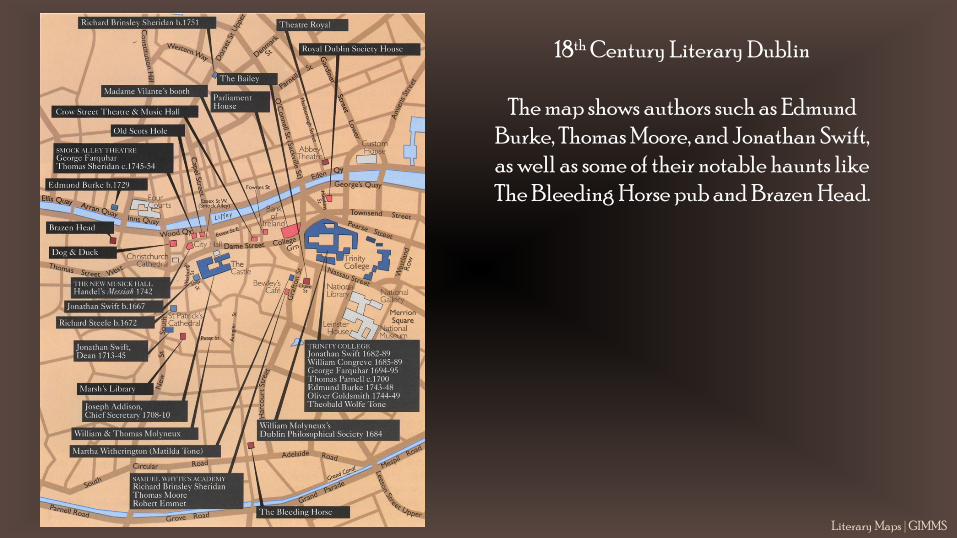
18th Century Literary Dublin
The map shows authors such as Edmund Burke, Thomas Moore, and Jonathan Swift, as well as some of their notable haunts like The Bleeding Horse pub and Brazen Head.
Literary Maps | GIMMS
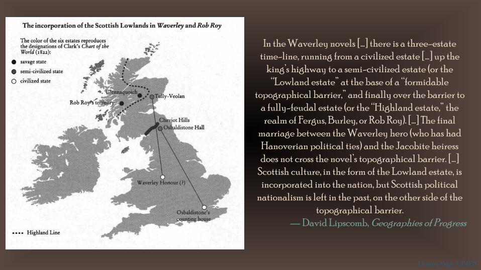
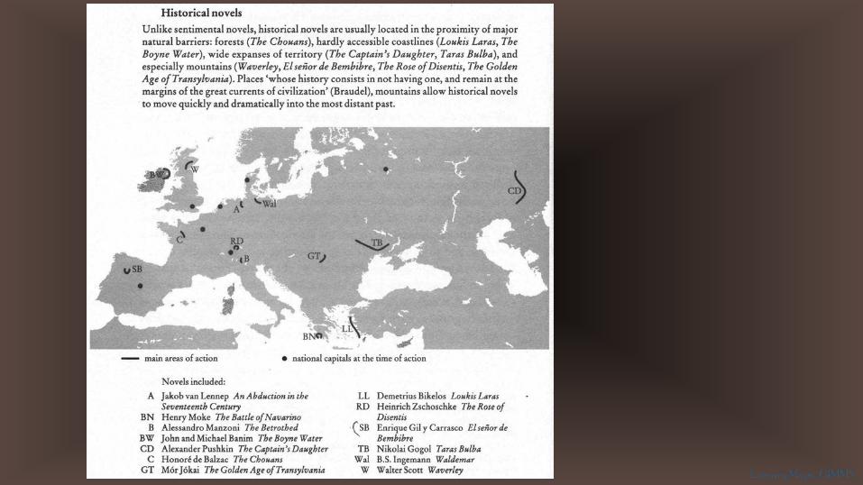
In the Waverley novels […] there is a three-estate time-line, running from a civilized estate […] up the
king’s highway to a semi-civilized estate (or the “Lowland estate” at the base of a “formidable
topographical barrier,” and finally over the barrier to a fully-feudal estate (or the “Highland estate,” the realm of Fergus, Burley, or Rob Roy). […] The final
marriage between the Waverley hero (who has had Hanoverian political ties) and the Jacobite heiress does not cross the novel’s topographical barrier. […]
Scottish culture, in the form of the Lowland estate, is incorporated into the nation, but Scottish political
nationalism is left in the past, on the other side of the topographical barrier.
— David Lipscomb, Geographies of Progress
Literary Maps | GIMMS
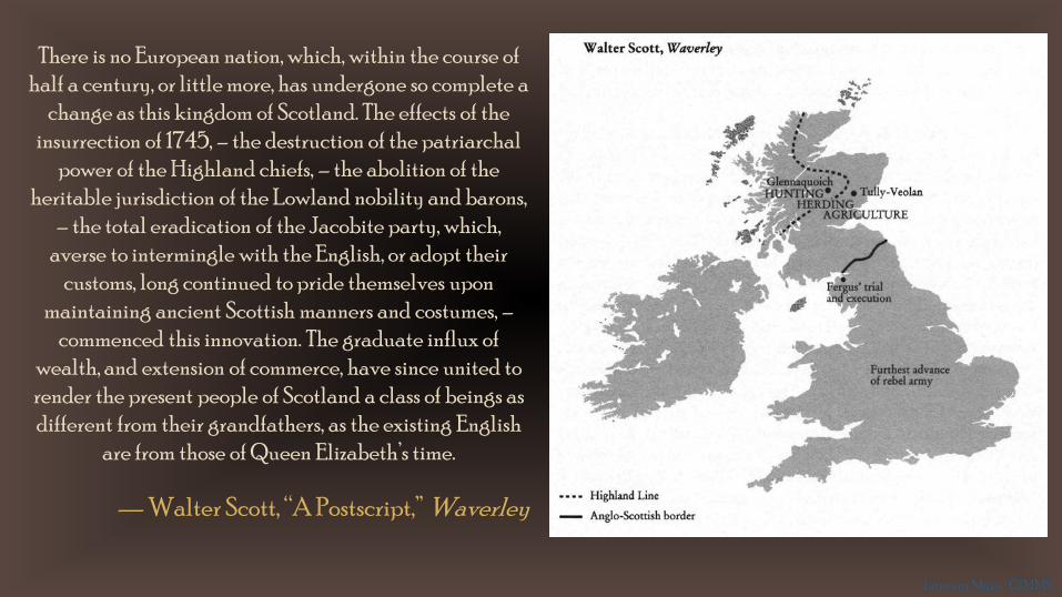
There is no European nation, which, within the course of half a century, or little more, has undergone so complete a
change as this kingdom of Scotland. The effects of the insurrection of 1745, – the destruction of the patriarchal
power of the Highland chiefs, – the abolition of the heritable jurisdiction of the Lowland nobility and barons,
– the total eradication of the Jacobite party, which, averse to intermingle with the English, or adopt their
customs, long continued to pride themselves upon maintaining ancient Scottish manners and costumes, –
commenced this innovation. The graduate influx of wealth, and extension of commerce, have since united to render the present people of Scotland a class of beings as different from their grandfathers, as the existing English
are from those of Queen Elizabeth’s time.
— Walter Scott, “A Postscript,” Waverley
Literary Maps | GIMMS

Literary places of Scandinavia
Literary Maps | GIMMS
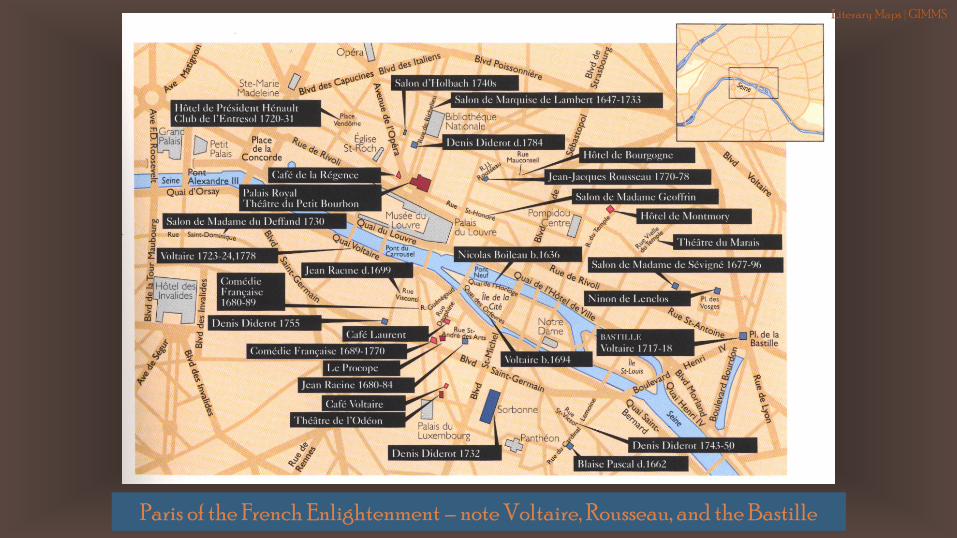
Paris of the French Enlightenment – note Voltaire, Rousseau, and the Bastille
Literary Maps | GIMMS
Literary Maps | GIMMS

Paris, 1920s
Literary Maps | GIMMS
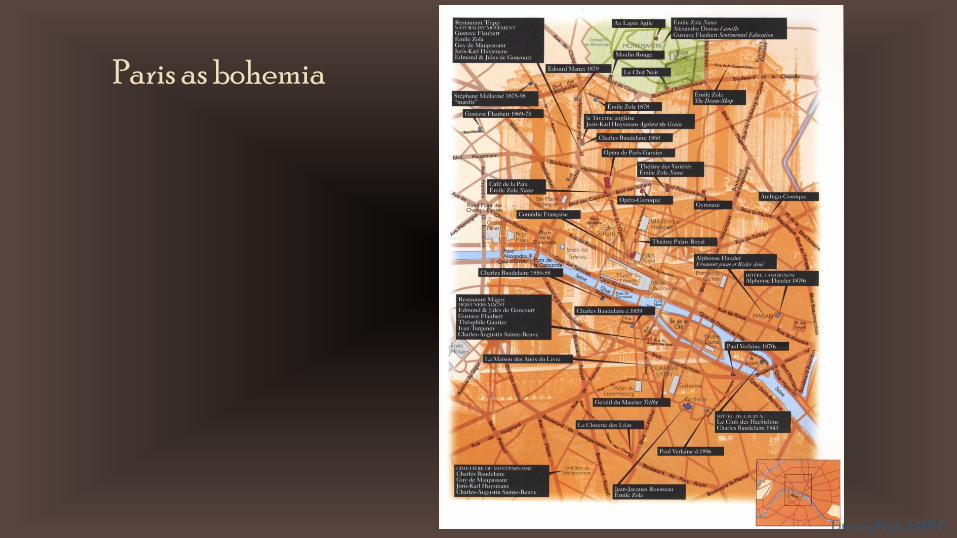
Paris as bohemia
Literary Maps | GIMMS
Literary Maps | GIMMS
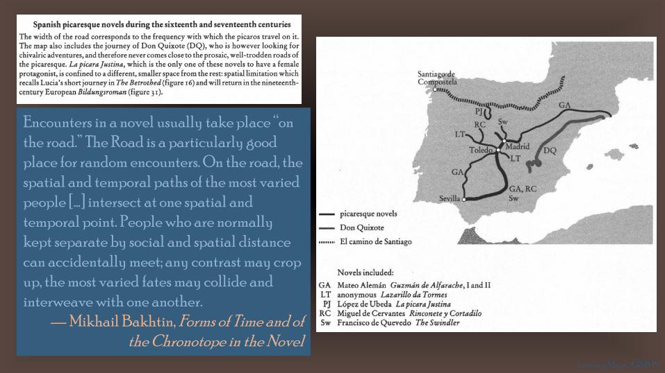
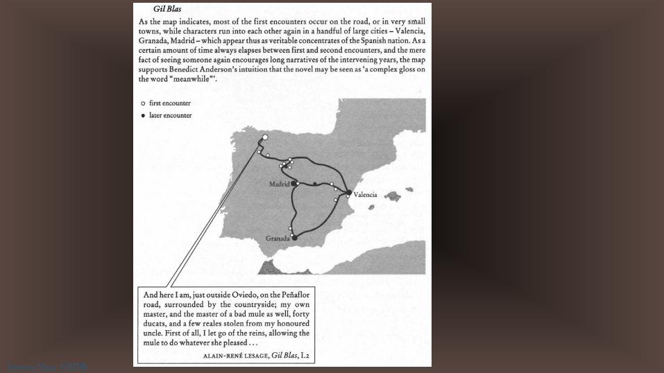
Encounters in a novel usually take place “on the road.” The Road is a particularly good place for random encounters. On the road, the spatial and temporal paths of the most varied people […] intersect at one spatial and temporal point. People who are normally kept separate by social and spatial distance can accidentally meet; any contrast may crop up, the most varied fates may collide and interweave with one another.
— Mikhail Bakhtin, Forms of Time and of the Chronotope in the Novel
Literary Maps | GIMMS
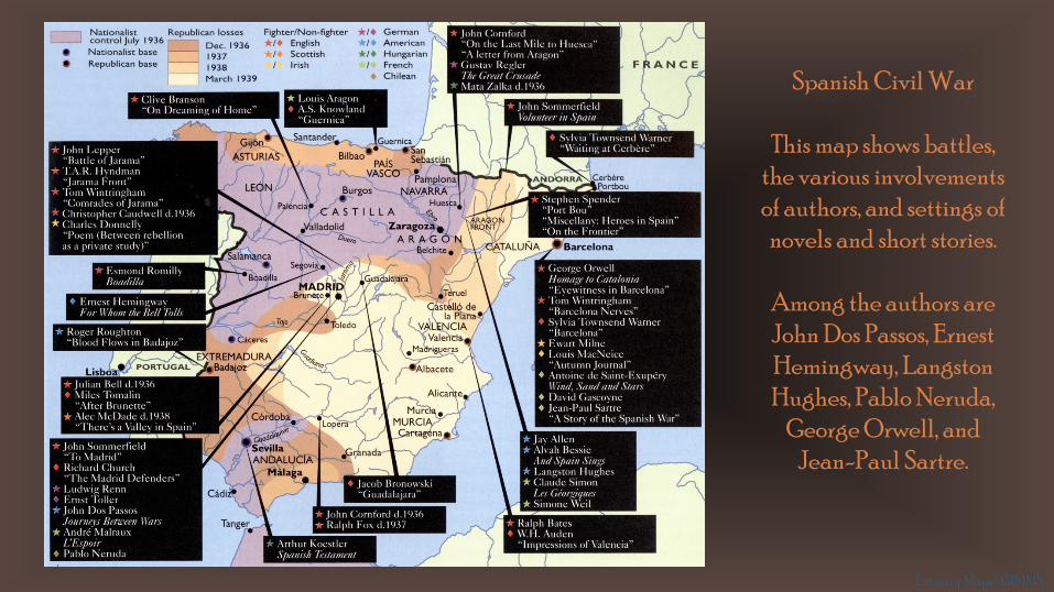
Spanish Civil War
This map shows battles, the various involvements of authors, and settings of
novels and short stories.
Among the authors are John Dos Passos, Ernest Hemingway, Langston Hughes, Pablo Neruda,
George Orwell, and Jean-Paul Sartre.
Literary Maps | GIMMS
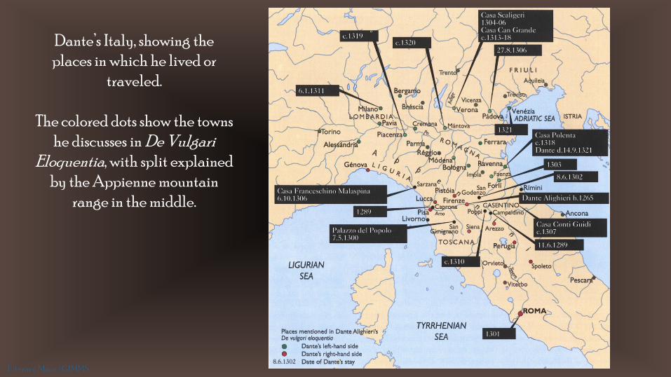
Dante’s Italy, showing the places in which he lived or
traveled.
The colored dots show the towns he discusses in De Vulgari
Eloquentia, with split explained by the Appienne mountain
range in the middle.
Literary Maps | GIMMS
Literary Maps | GIMMS
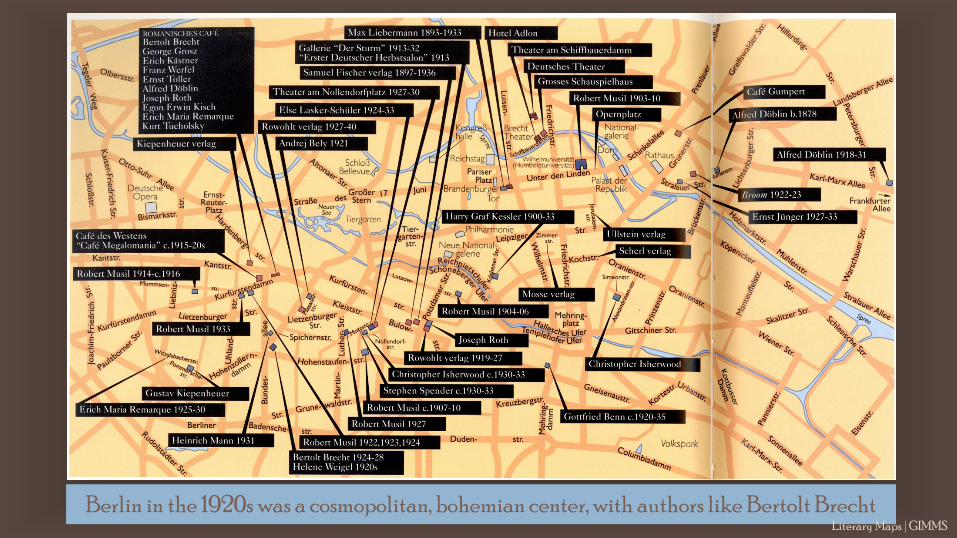
Berlin in the 1920s was a cosmopolitan, bohemian center, with authors like Bertolt BrechtLiterary Maps | GIMMS
Literary Maps | GIMMS
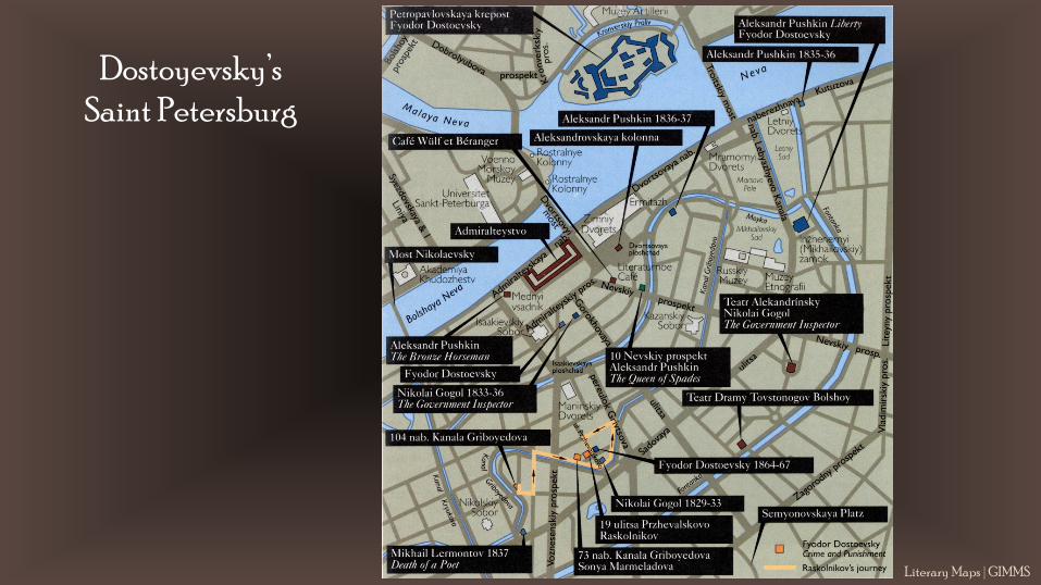
Dostoyevsky’s Saint Petersburg
Literary Maps | GIMMS
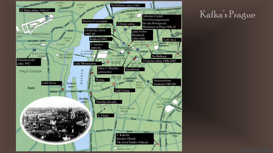
Kafka’s Prague
Literary Maps | GIMMS
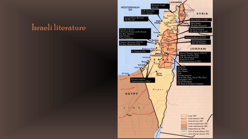
Israeli literature
Literary Maps | GIMMS

20th Century Arabic world literature
Produced a few years too early, an updated map would almost certainly also show Marjane Satrapi’sPersepolis (2000). Her graphic novel takes place in Iran during and after the Islamic revolution, and takes its title from the ancient capital of the Persian Empire.
Literary Maps | GIMMS
Literary Maps | GIMMS
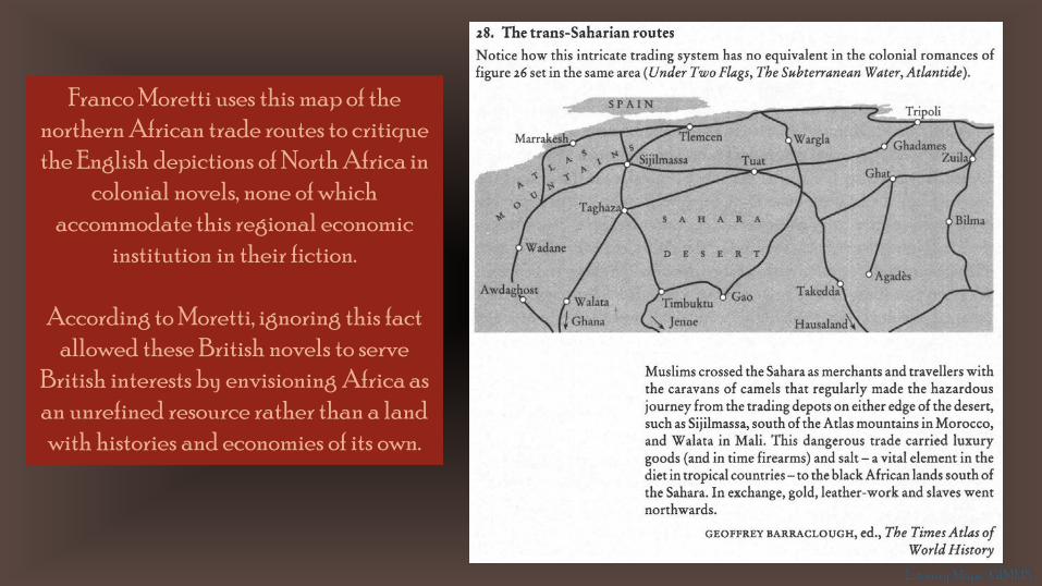
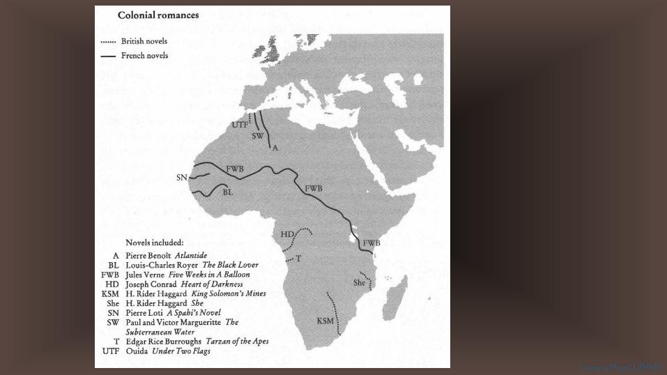
Franco Moretti uses this map of the northern African trade routes to critique the English depictions of North Africa in
colonial novels, none of which accommodate this regional economic
institution in their fiction.
According to Moretti, ignoring this fact allowed these British novels to serve
British interests by envisioning Africa as an unrefined resource rather than a land with histories and economies of its own.
Literary Maps | GIMMS
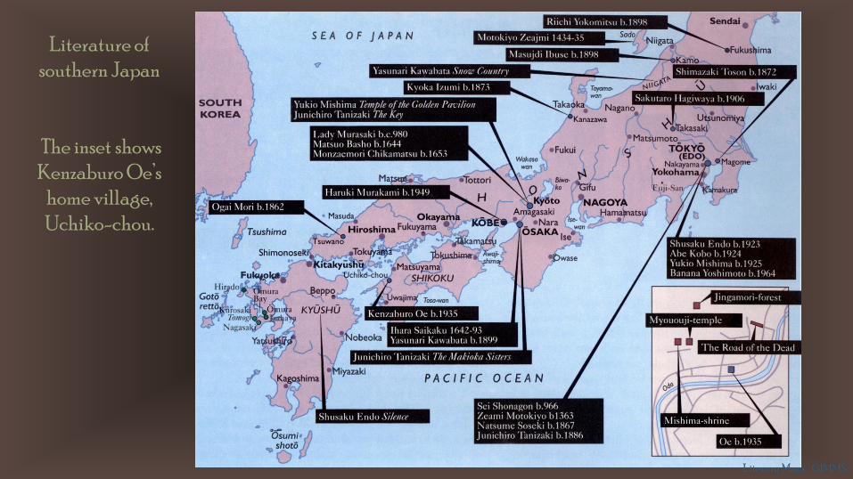
Literature of southern Japan
The inset shows Kenzaburo Oe’s
home village, Uchiko-chou.
Literary Maps | GIMMS
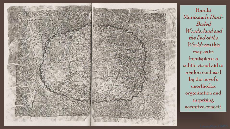
HarukiMurakami’s Hard-
Boiled Wonderland and
the End of the World uses this
map as its frontispiece, a
subtle visual aid to readers confused
by the novel’s unorthodox
organization and surprising
narrative conceit.
Literary Maps | GIMMS


![2008 Literary Elements Slideshow[1] 1](https://img.pdfslide.net/doc/110x75/54c81f094a795988538b458a/2008-literary-elements-slideshow1-1.jpg)