Embed Size (px)
Citation preview
Severn Estuary SMP2 WFD Assessment
Version 3
Last printed: 04/05/10
Page 1
Appendix J: Water Framework
Directive Assessment
Severn Estuary SMP2 WFD Assessment
Version 3
Last printed: 04/05/10
Page 2
Appendix J
Water Framework Directive Assessment
Severn Estuary SMP2
Severn Estuary SMP2 WFD Assessment
Version 3
Last printed: 04/05/10
Page 3
Water Framework Directive Assessment Page 1.0 INTRODUCTION 8 1.1 Purpose of the Report 8 1.2 Background 8 2.0 ASSESSMENT METHODOLOGY 10
2.1 Scoping the SMP2 – Data Collation 10 2.2 Defining Features and Issues 11 2.3 Assess preferred policies against WFD environmental objectives 11
3.0 RESULTS
13
3.1 Scoping the SMP2 – Data Collation 13 3.2 Defining Features and Issues 23
3.3 Assess preferred policies against WFD environmental objectives 23 4.0 CONCLUSIONS
47
REFERENCES 48
LIST OF FIGURES
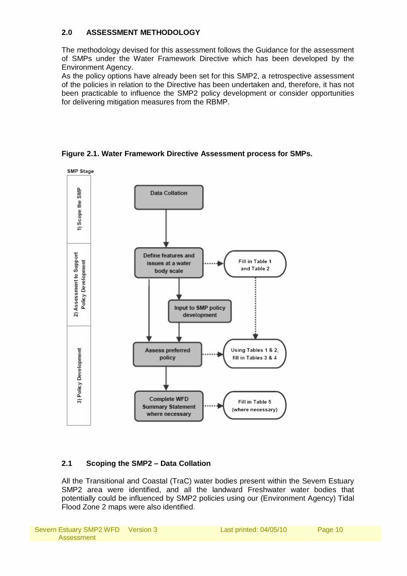
Figure 2.1. Water Framework Directive Assessment process for SMPs.
10
Figure 3.1 TraC Waterbodies within the Severn Estuary SMP2 Area 15 Figure 3.2 Groundwater Body Chemical Risk within the Severn Estuary
SMP2 Area. 18
Figure 3.3 Groundwater Body Chemical Status within the Severn Estuary SMP2 Area.
19
Figure 3.4 Groundwater Body Source Protection Zones within the Severn Estuary SMP2 Area.
20
Figure 3.5 SMP2 Management Area and WFD Waterbody boundaries at Uskmouth.
22
Figure 3.6 SMP2 Management Area and WFD Waterbody boundaries at mouth of the River Wye and Old Passage.
23
LIST OF TABLES
Table 1.1 Environmental Objectives in the Directive.
9
Table 3.1 Landward Freshwater bodies that have the potential to be impacted by the Severn Estuary SMP2 policies.
14
Table 3.2 Groundwater Body Issues. 16 Assessment Table 1a. Biological Quality Indicators for Coastal Waterbodies. 26 Assessment Table 1b. Biological Quality Indicators for Transitional
Waterbodies. 27
Assessment Table 1c. Biological Quality Indicators for River Waterbodies. 28 Assessment Table 1d. Biological Quality Indicators for Lake Waterbodies. 30 Assessment Table 2. Features and Issues Table. 31 Assessment Table 3. Assessment of SMP Policy against the Environmental
Objectives of the WFD. 35
Assessment Table 4. Summary of achievement (or otherwise) of environmental objectives for each water body in the SMP area.
42
Assessment Table 5. WFD Summary Statements. 43
Severn Estuary SMP2 WFD Assessment
Version 3
Last printed: 04/05/10
Page 4
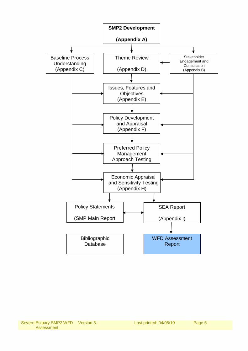
Supporting Appendices Information required to support the Severn Estuary Shoreline Management Plan Review (SMP2) is provided in the following appendices. These supporting documents offer transparency to the decision making process that is undertaken, leading to explanations and reasoning for the promoted policies.
A: SMP2 Development The history, structure and development of the SMP are detailed in this report. The investigation and decision making process are explained more fully to outline the procedure to setting policy.
B: Stakeholder Engagement and Consultation
Stakeholder communication is continuous through the SMP2 process, comments on the progress of the management plan are recorded here.
C: Baseline Process Understanding
This report includes detail of coastal dynamics, defence data and shoreline scenario assessments of NAI (No Active Intervention – defences are not maintained, repaired or replaced allowing the shoreline to evolve more naturally) and With Present Management (WPM) i.e.: SMP1 Policy.
D: Theme Review The identification and evaluation of the natural landscape and conservation, the historic environment and present and future land use of the shoreline.
E: Issues, Features and Objectives The features of the shoreline are listed within this report. A series of strategic objectives are then set along with commentary on the relative importance of each feature identified.
F: Policy Development and Appraisal
Presents the consideration of generic policy options for each frontage identifying possible acceptable policies and their combination into ‘Management Approaches’ for testing. Also presents the appraisal of impacts upon shoreline evolution and the appraisal of objective achievement.
G: Preferred Policy Management Approach Testing
Presents the policy assessment of appraisal of objective achievement towards definition of the Preferred Plan (as presented in the Shoreline Management Plan document).
H: Economic Appraisal and Sensitivity Testing
Presents the economic analysis undertaken in support of the Preferred Plan.
I: Strategic Environmental Assessment Report
Presents the various items undertaken in developing the Plan that specifically relate to the requirements of the EU Council Directive 2001/42/EC (the Strategic Environmental Assessment Directive), such that all of this information is readily accessible in one document. This includes information to support towards a Habitat Regulatory Assessment (HRA).
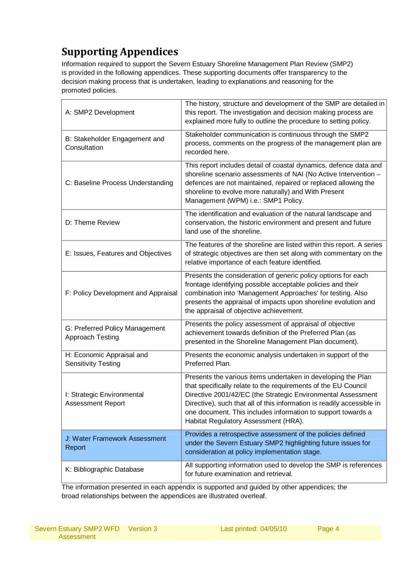
J: Water Framework Assessment Report
Provides a retrospective assessment of the policies defined under the Severn Estuary SMP2 highlighting future issues for consideration at policy implementation stage.
K: Bibliographic Database All supporting information used to develop the SMP is references for future examination and retrieval.
The information presented in each appendix is supported and guided by other appendices; the broad relationships between the appendices are illustrated overleaf.
Severn Estuary SMP2 WFD Assessment
Version 3
Last printed: 04/05/10
Page 5
SMP2 Development
(Appendix A)
Baseline Process Understanding (Appendix C)
Theme Review
(Appendix D)
Stakeholder Engagement and
Consultation (Appendix B)
Issues, Features and Objectives
(Appendix E)
Policy Development and Appraisal (Appendix F)
Preferred Policy Management
Approach Testing
Economic Appraisal
and Sensitivity Testing (Appendix H)
Policy Statements
(SMP Main Report
SEA Report
(Appendix I)
Bibliographic Database
WFD Assessment Report
Severn Estuary SMP2 WFD Assessment
Version 3
Last printed: 04/05/10
Page 6
Executive Summary The Water Framework Directive (referred to in this report as the Directive) came into force in 2000 and is the most substantial piece of EU water legislation to date. The Directive will need to be taken into account in the planning of all new activities in the water environment including Shoreline Management Plans. The methodology devised for this assessment follows the Guidance for the assessment of SMPs under the Water Framework Directive which has been developed by the Environment Agency. As the draft policy options have already been set for this SMP2, a retrospective assessment of the policies in relation to the Directive has been undertaken and, therefore, it has not been practicable to influence the SMP2 policy development or consider opportunities for delivering mitigation measures from the River Basin Management Plan (RBMP). All the Transitional and Coastal (TraC) and Groundwater Bodies in the Severn Estuary SMP2 area were identified and assessed along with the Freshwater bodies that are within EA’s Tidal Flood Zone 2 (up to 0.5% chance of flooding in any one year). For all TraC and Freshwater water bodies in the SMP2 area, the hydromorphological parameters that could be changed by potential SMP2 policies, with potential impact on the Biological Quality Elements (BQEs), were identified. Groundwater bodies were also considered. The preferred SMP2 policies were, for each policy unit and for each epoch, assessed against the Environmental Objectives and a summary of the achievement (or otherwise) of the Environmental Objectives at the water body scale was completed. Where any Environmental Objectives have not been met within a water body a Water Framework Directive Summary Statement was completed for that water body. If all the Environmental Objectives were met within a water body there was no requirement to complete a Summary Statement. There are 4 TraC water bodies, 54 River waterbodies 1 Lake waterbody and 12 Groundwater bodies identified in the Severn Estuary SMP2 area. There are no High Status sites in the Severn Estuary SMP2 Area. For many of the Severn Estuary SMP2 Management Areas, it is considered unlikely that the proposed policies will affect the current or target Ecological Status (or Potential) of the relevant Water Framework Directive waterbodies. Therefore, the proposed policies meet the Environmental Objectives set out at the beginning of this report. However, there are 7 Management Areas where the proposed policies have the potential not to meet one or more the Environmental Objectives. These being: Cardiff – potential failure to meet WFD 2. Wentlooge – potential failure to meet WFD 2 & WFD 3. Caldicot Levels – potential failure to meet WFD 2 & WFD 3. Lydney – potential failure to meet WFD 2. Lydney to Gloucester – potential failure to meet WFD 2 & WFD 3. Sharpness to Severn Crossing – potential failure to meet WFD 2 & WFD 3. Bristol and Severnside – potential failure to meet WFD 2 & WFD 3.

Severn Estuary SMP2 WFD Assessment
Version 3
Last printed: 04/05/10
Page 7
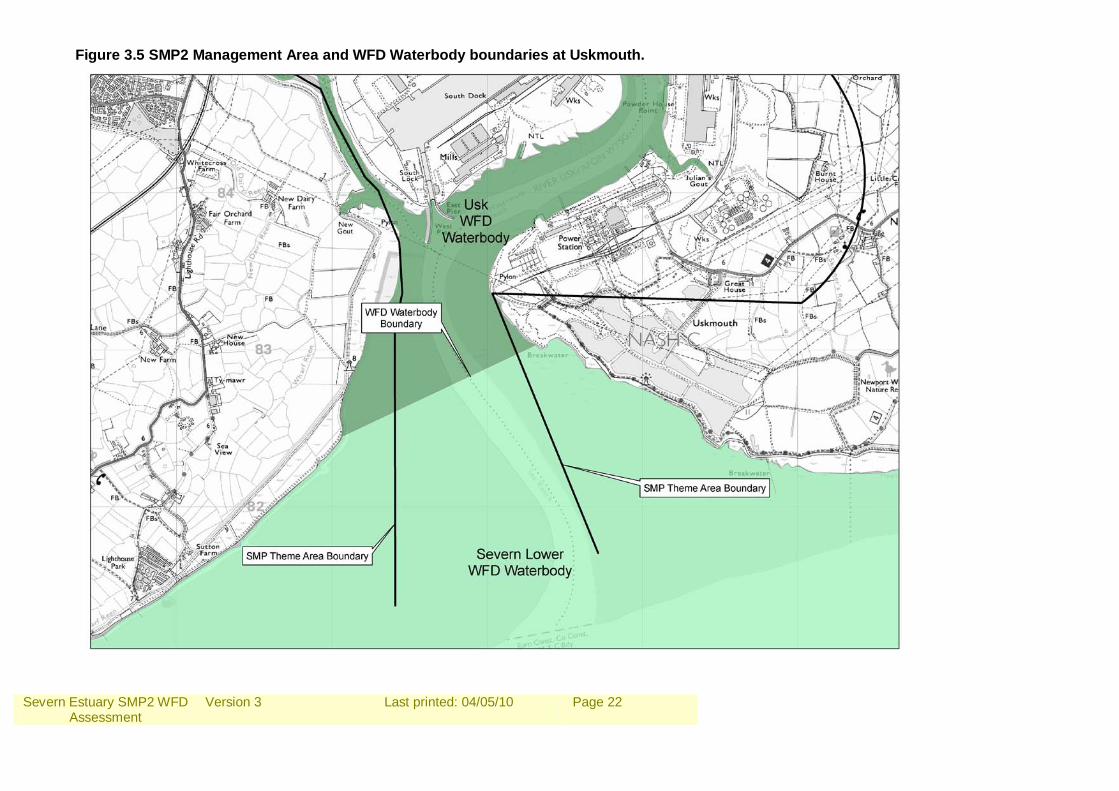
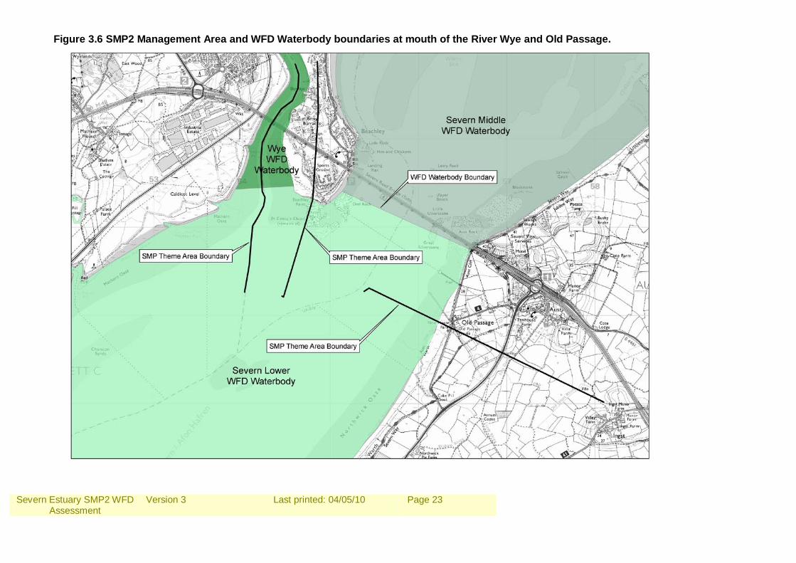
There are several recommendations to look into where SMP boundaries could change to match those of the WFD waterbody boundaries, notably at Uskmouth, the mouth of the River Wye and at Old Passage. However, SMP Management Area boundaries are based on coastal processes and social and economic reasons and are realistically unlikely to change.
Severn Estuary SMP2 WFD Assessment
Version 3
Last printed: 04/05/10
Page 8
1.0 INTRODUCTION 1.1 Purpose of the Report The Water Framework Directive (referred to in this report as the Directive) came into force in 2000 and is the most substantial piece of EU water legislation to date. The Directive will need to be taken into account in the planning of all new activities in the water environment. Therefore, the Environment Agency (the competent authority in England and Wales responsible for delivering the Directive) has recommended that decisions setting policy, including large-scale plans such as Shoreline Management Plans (SMPs), take account of the requirements of the Directive. The ‘Water Framework Directive Guidance for the Assessment of SMPs’ has recently been developed by the Environment Agency and the first pilot assessment has been undertaken on the River Tyne to Flamborough Head SMP2. The guidance describes the methodology for assessing the potential hydromorphological change and consequent ecological impact of SMP policies and ensuring that SMP policy setting takes account of the Directive. This guidance can now be applied to the assessment of the Severn Estuary SMP2 policy options in terms of the requirements of the Directive. The Severn Estuary SMP2 draft policy options were completed in September 2009 and, therefore, it is not feasible for the Water Framework Directive assessment to influence the SMP2 policy development or consider opportunities for delivering mitigation measures from the River Basin Management Plan. Consequently, this report provides a retrospective assessment of the policies defined under the Severn Estuary SMP2 highlighting future issues for consideration at policy implementation stage. 1.2 Background The EU Water Framework Directive was transposed into law in England and Wales by the Water Environment (Water Framework Directive) (England and Wales) Regulations 2003. The requirements of the Directive need to be considered at all stages of the river and coastal planning and development process. For the purposes of large-scale plans, such as SMPs, the consideration of the requirements of the Directive when setting and selecting policies must be necessarily high level but sets the framework for future delivery of smaller-scale strategies or schemes. The Directive requires that Environmental Objectives be set for all surface and groundwaters in each EU member state. The default Environmental Objectives of relevance to the SMP2 are shown in Table 1.1. Specific mitigation measures will be set for each River Basin District (RBD) to achieve the Environmental Objectives of the Directive. These measures are to mitigate impacts that have been or are being caused by human activity. In other words, measures to enhance and restore the quality of the existing environment. These mitigation measures will be delivered through the River Basin Management Plan (RBMP) process and listed in a Programme of Measures within the RBMP. The RBMPs are currently in draft and undergoing public consultation with the final plans due to be produced in December 2009.
Severn Estuary SMP2 WFD Assessment
Version 3
Last printed: 04/05/10
Page 9
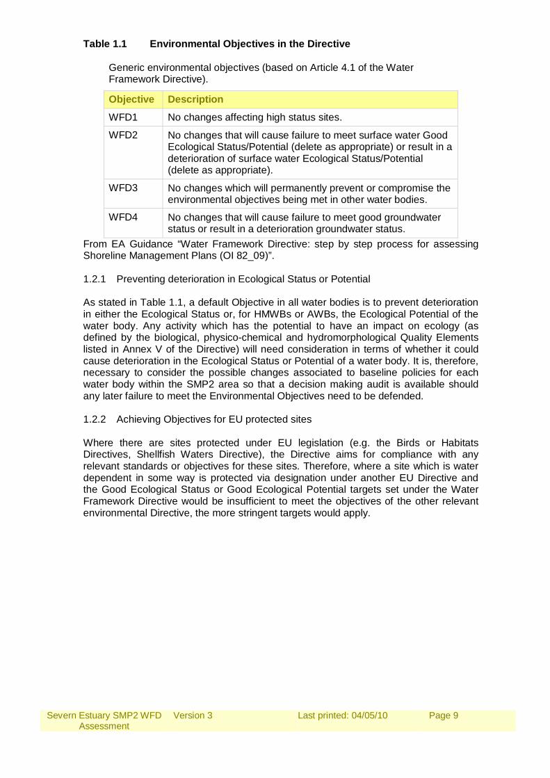
Table 1.1 Environmental Objectives in the Directive
Generic environmental objectives (based on Article 4.1 of the Water Framework Directive).
Objective Description
WFD1 No changes affecting high status sites.
WFD2 No changes that will cause failure to meet surface water Good Ecological Status/Potential (delete as appropriate) or result in a deterioration of surface water Ecological Status/Potential (delete as appropriate).
WFD3 No changes which will permanently prevent or compromise the environmental objectives being met in other water bodies.
WFD4 No changes that will cause failure to meet good groundwater status or result in a deterioration groundwater status.
From EA Guidance “Water Framework Directive: step by step process for assessing Shoreline Management Plans (OI 82_09)”. 1.2.1 Preventing deterioration in Ecological Status or Potential As stated in Table 1.1, a default Objective in all water bodies is to prevent deterioration in either the Ecological Status or, for HMWBs or AWBs, the Ecological Potential of the water body. Any activity which has the potential to have an impact on ecology (as defined by the biological, physico-chemical and hydromorphological Quality Elements listed in Annex V of the Directive) will need consideration in terms of whether it could cause deterioration in the Ecological Status or Potential of a water body. It is, therefore, necessary to consider the possible changes associated to baseline policies for each water body within the SMP2 area so that a decision making audit is available should any later failure to meet the Environmental Objectives need to be defended. 1.2.2 Achieving Objectives for EU protected sites Where there are sites protected under EU legislation (e.g. the Birds or Habitats Directives, Shellfish Waters Directive), the Directive aims for compliance with any relevant standards or objectives for these sites. Therefore, where a site which is water dependent in some way is protected via designation under another EU Directive and the Good Ecological Status or Good Ecological Potential targets set under the Water Framework Directive would be insufficient to meet the objectives of the other relevant environmental Directive, the more stringent targets would apply.
Severn Estuary SMP2 WFD Assessment
Version 3
Last printed: 04/05/10
Page 10
2.0 ASSESSMENT METHODOLOGY The methodology devised for this assessment follows the Guidance for the assessment of SMPs under the Water Framework Directive which has been developed by the Environment Agency. As the policy options have already been set for this SMP2, a retrospective assessment of the policies in relation to the Directive has been undertaken and, therefore, it has not been practicable to influence the SMP2 policy development or consider opportunities for delivering mitigation measures from the RBMP. Figure 2.1. Water Framework Directive Assessment process for SMPs.
2.1 Scoping the SMP2 – Data Collation All the Transitional and Coastal (TraC) water bodies present within the Severn Estuary SMP2 area were identified, and all the landward Freshwater water bodies that potentially could be influenced by SMP2 policies using our (Environment Agency) Tidal Flood Zone 2 maps were also identified.
Severn Estuary SMP2 WFD Assessment
Version 3
Last printed: 04/05/10
Page 11
For each of these waterbodies’ its WFD ID number, classification details (including Biological Quality Element (BQE) information and Artificial / Heavily Modified Water Body designation) and its Environmental Objectives were identified, as far as possible from the Draft River Basin Management Plan. All the Groundwater bodies (GWBs) that could potentially be impacted by SMP policies were identified by reviewing the Water Framework Directive compliance mapping for groundwater risk and the GWBs designated as being ‘at risk’, ‘probably at risk’ or at ‘Poor Status’, with regard to saline intrusion, within the SMP2 area. Again for each waterbody its ID number, classification details and Environmental Objectives were identified The locations of groundwater abstractions with Source Protection Zones (SPZs) within the SMP2 area were also identified. Any discrepancies between water body boundaries and SMP2 boundaries were examined and any locations where changes of the SMP2 boundary would be recommended to attain consistency with water body boundaries were identified for the next round of SMPs. 2.2 Defining Features and Issues The next step was to identify the relationships between Biological Quality Elements and their physical dependencies for each of the Water Framework Directive Waterbodies. The Water Framework Directive features which SMP2 policies may affect are the Biological Quality Elements (BQEs) of water bodies. The issues are the hydromorphological and physical parameters (upon which the BQEs are dependent) that could potentially be changed. For all TraC and Freshwater bodies in the SMP2 area, the hydromorphological parameters that could be changed by potential SMP2 policies, with potential impact on the BQEs, were identified using Assessment Tables 1a, 1b, 1c and 1d. The key features and issues identified in Assessment Tables 1a – 1d were then transferred into Assessment Table 2 and the water body classification and Environmental Objectives set out in Section 2.1 were used to populate the final column of Assessment Table 2. 2.3 Assess preferred SMP policies against WFD environmental objectives The preferred SMP2 policies were, for each policy unit and each epoch, confirmed and recorded in Assessment Table 3. The policies were then assessed against the Environmental Objectives (Table 1.1). Using the information provided in Assessment Tables 1a – 1d and Assessment Table 2, the potential impacts of the short term SMP2 policy for each Management Area was assessed against the Environmental Objectives. The potential changes to the relevant physical and hydromorphological parameters were identified and noted. The assessment of the SMP2 policies also considered potential for them to impact upon any landward Freshwater bodies. These landward Freshwater bodies could potentially be impacted where SMP policy for a policy unit is No Active Intervention (NAI) or Managed Realignment (MR), as these policies could result in saline inundation of a Freshwater habitat, or Hold The Line (HTL) as tide locking could occur in adjacent Waterbodies as a result of sea level rise. Groundwater bodies were also considered as NAI and MR policies could result in the Freshwater – saltwater interface moving landwards, which combined with abstraction pressures could result in saline intrusion and deterioration of the Groundwater body.
Severn Estuary SMP2 WFD Assessment
Version 3
Last printed: 04/05/10
Page 12
For Management Areas where the extent of the total catchment of the groundwater abstraction (identified by zone 3 of Source Protection Zone) extended to the coastline, it was considered that an SMP2 policy could potentially cause deterioration in the quality of the abstraction due to saline intrusion. Consideration was also given to Transitional and Coastal waterbodies where SMP2 policies could lead to a deterioration in status or potential as a result of groundwater pollution. Following the assessment of SMP policies for each Policy Unit, a summary of the achievement (or otherwise) of the environmental objectives at the water body scale was completed (Assessment Table 4). This table also considers the cumulative effect of SMP policies on each water body. Where any environmental objectives have not be met for one or more Management Areas within a water body, then in order to document the justification behind the selection of the preferred SMP policy, a Water Framework Directive Summary Statement was completed for that Waterbody (assessment table 5).
If all the environmental objectives were met within a Waterbody there was no requirement to complete a Summary Statement.
As this is a retrospective assessment, completed once the preferred policies have been established, the WFD summary statements can be used to make a note of areas where the WFD objectives could be compromised by future delivery of SMP policies, and how the Article 4.7 can or cannot be used to defend this. These issues must be taken into account in subsequent SMP policy delivery stages.
Any recommendations for local management options, further investigations or monitoring requirements that are made in the Water Framework Directive summary statement, are also included in the action plan within the SMP report, together with any associated deadlines or suggested timescales.
Severn Estuary SMP2 WFD Assessment
Version 3
Last printed: 04/05/10
Page 13
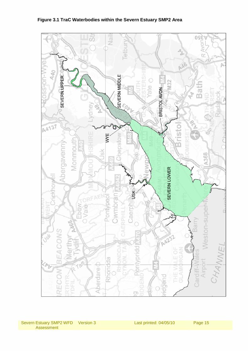
3.0 RESULTS 3.1 Scoping the SMP2 – Data Collation 3.1.1 Transitional and Coastal water bodies (TraC) There are 6 TraC water bodies (Assessment Tables 1a & 1b) within the Severn Estuary SMP2 area (Figure 3.1). Including 6 Transitional water bodies, 5 of which are designated as Candidate Heavily Modified and 1 which is not yet designated in the River Basin Management Plan. There are no Coastal waterbodies. 3.1.2 Freshwater bodies (FWBs) There are 54 River waterbodies identified (Assessment Table 1c) in the Severn Estuary SMP2 area and 1 Lake waterbody (Assessment Table 1d). Of these, 17 River waterbodies are designated as Candidate Heavily Modified, 23 Candidate Artificial and 13 not yet designated under the River Basin Management Plan. Relevant Freshwater bodies were identified as those that are with Tidal Flood Zone 3 and within the SMP2 area. It should be noted that some River waterbodies within the SMP2 area have been ruled out as they are either located on a section of coastline that is not connected to the tidal flood plain (eg cliffed section or steeply sloping channel), or they are protected by flood defences and dunes etc. There is little potential flood plain and landward recession of the mouths of these Freshwater rivers and is not likely to impact them as waterbodies. Any issues or potential impacts of the Severn Estuary SMP2 policy that affects landward Freshwater bodies have been identified in the table below.
Severn Estuary SMP2 WFD Assessment
Version 3
Last printed: 04/05/10
Page 14
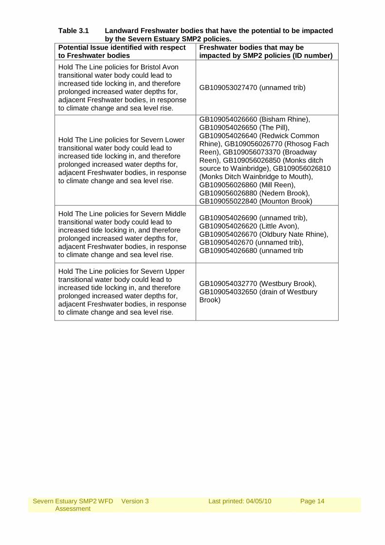
Table 3.1 Landward Freshwater bodies that have the potential to be impacted by the Severn Estuary SMP2 policies.
Potential Issue identified with respect to Freshwater bodies
Freshwater bodies that may be impacted by SMP2 policies (ID number)
Hold The Line policies for Bristol Avon transitional water body could lead to increased tide locking in, and therefore prolonged increased water depths for, adjacent Freshwater bodies, in response to climate change and sea level rise.
GB109053027470 (unnamed trib)
Hold The Line policies for Severn Lower transitional water body could lead to increased tide locking in, and therefore prolonged increased water depths for, adjacent Freshwater bodies, in response to climate change and sea level rise.
GB109054026660 (Bisham Rhine), GB109054026650 (The Pill), GB109054026640 (Redwick Common Rhine), GB109056026770 (Rhosog Fach Reen), GB109056073370 (Broadway Reen), GB109056026850 (Monks ditch source to Wainbridge), GB109056026810 (Monks Ditch Wainbridge to Mouth), GB109056026860 (Mill Reen), GB109056026880 (Nedern Brook), GB109055022840 (Mounton Brook)
Hold The Line policies for Severn Middle transitional water body could lead to increased tide locking in, and therefore prolonged increased water depths for, adjacent Freshwater bodies, in response to climate change and sea level rise.
GB109054026690 (unnamed trib), GB109054026620 (Little Avon), GB109054026670 (Oldbury Nate Rhine), GB10905402670 (unnamed trib), GB109054026680 (unnamed trib
Hold The Line policies for Severn Upper transitional water body could lead to increased tide locking in, and therefore prolonged increased water depths for, adjacent Freshwater bodies, in response to climate change and sea level rise.
GB109054032770 (Westbury Brook), GB109054032650 (drain of Westbury Brook)
Severn Estuary SMP2 WFD Assessment
Version 3
Last printed: 04/05/10
Page 15
Figure 3.1 TraC Waterbodies within the Severn Estuary SMP2 Area
Severn Estuary SMP2 WFD Assessment
Version 3
Last printed: 04/05/10
Page 16
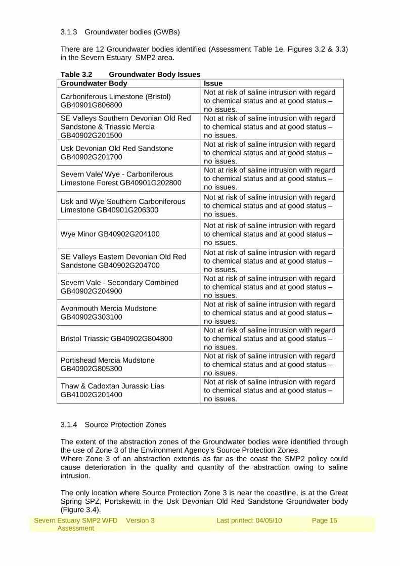
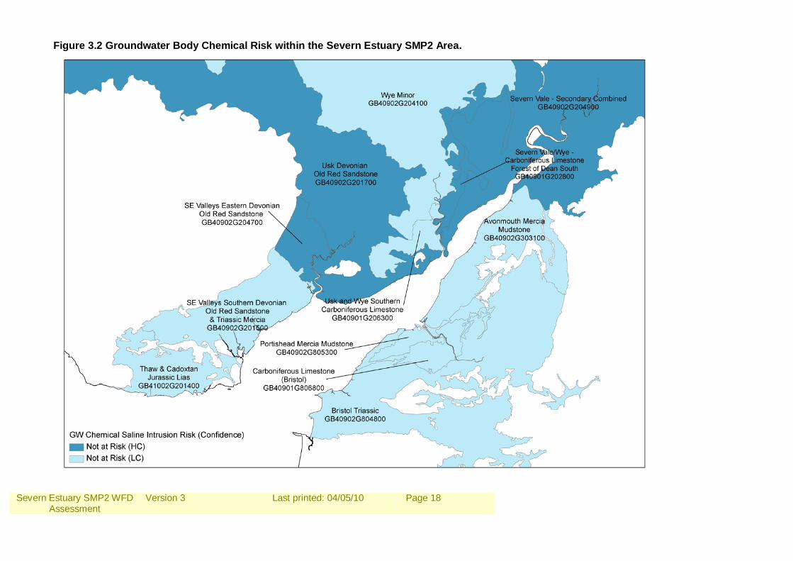
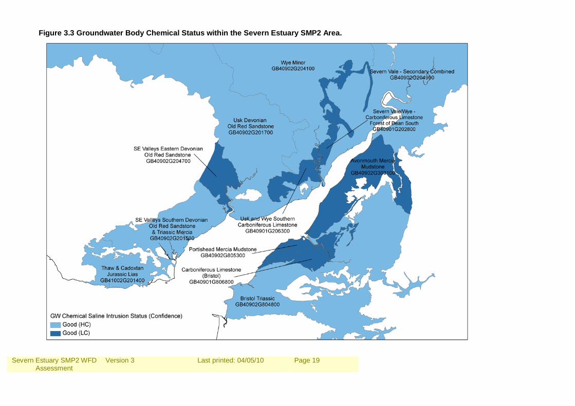
3.1.3 Groundwater bodies (GWBs) There are 12 Groundwater bodies identified (Assessment Table 1e, Figures 3.2 & 3.3) in the Severn Estuary SMP2 area. Table 3.2 Groundwater Body Issues Groundwater Body Issue
Carboniferous Limestone (Bristol) GB40901G806800
Not at risk of saline intrusion with regard to chemical status and at good status – no issues.
SE Valleys Southern Devonian Old Red Sandstone & Triassic Mercia GB40902G201500
Not at risk of saline intrusion with regard to chemical status and at good status – no issues.
Usk Devonian Old Red Sandstone GB40902G201700
Not at risk of saline intrusion with regard to chemical status and at good status – no issues.
Severn Vale/ Wye - Carboniferous Limestone Forest GB40901G202800
Not at risk of saline intrusion with regard to chemical status and at good status – no issues.
Usk and Wye Southern Carboniferous Limestone GB40901G206300
Not at risk of saline intrusion with regard to chemical status and at good status – no issues.
Wye Minor GB40902G204100 Not at risk of saline intrusion with regard to chemical status and at good status – no issues.
SE Valleys Eastern Devonian Old Red Sandstone GB40902G204700
Not at risk of saline intrusion with regard to chemical status and at good status – no issues.
Severn Vale - Secondary Combined GB40902G204900
Not at risk of saline intrusion with regard to chemical status and at good status – no issues.
Avonmouth Mercia Mudstone GB40902G303100
Not at risk of saline intrusion with regard to chemical status and at good status – no issues.
Bristol Triassic GB40902G804800 Not at risk of saline intrusion with regard to chemical status and at good status – no issues.
Portishead Mercia Mudstone GB40902G805300
Not at risk of saline intrusion with regard to chemical status and at good status – no issues.
Thaw & Cadoxtan Jurassic Lias GB41002G201400
Not at risk of saline intrusion with regard to chemical status and at good status – no issues.
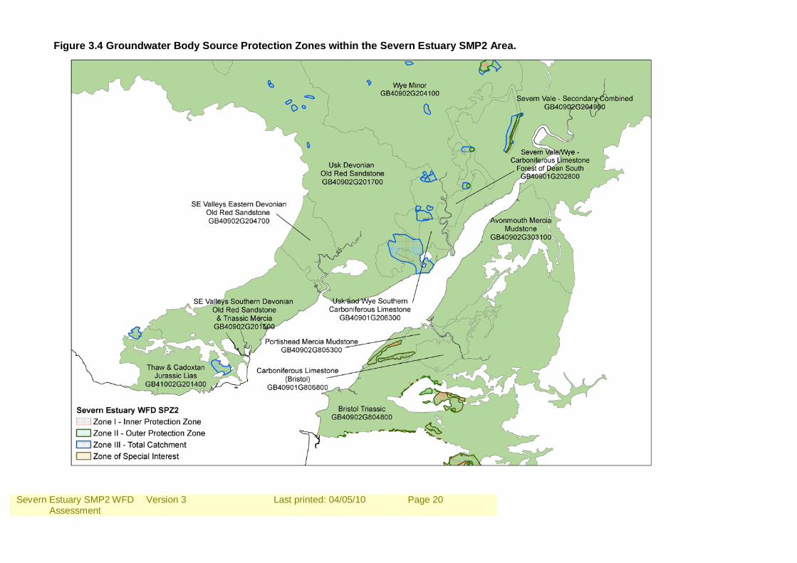
3.1.4 Source Protection Zones The extent of the abstraction zones of the Groundwater bodies were identified through the use of Zone 3 of the Environment Agency’s Source Protection Zones. Where Zone 3 of an abstraction extends as far as the coast the SMP2 policy could cause deterioration in the quality and quantity of the abstraction owing to saline intrusion. The only location where Source Protection Zone 3 is near the coastline, is at the Great Spring SPZ, Portskewitt in the Usk Devonian Old Red Sandstone Groundwater body (Figure 3.4).
Severn Estuary SMP2 WFD Assessment
Version 3
Last printed: 04/05/10
Page 17
SMP2 Policy has the potential to cause the deterioration in the quality of abstractions due to saline intrusions where there are Managed Realignment or No Active Intervention policies. The policy covering this area in the SMP2 is Hold The Line and there are no issues regarding deterioration in the quality of abstractions due to saline intrusions, except for a small section of No Active Intervention policy in policy unit CALD2. High ground and hard geology in this unit limits the risk of flooding and erosion and as there are no linkages between this policy unit and those either side, it is not considered likely to cause potential deterioration in the quality of abstractions due to saline intrusion.
Severn Estuary SMP2 WFD Assessment
Version 3
Last printed: 04/05/10
Page 18
Figure 3.2 Groundwater Body Chemical Risk within the Severn Estuary SMP2 Area.
Severn Estuary SMP2 WFD Assessment
Version 3
Last printed: 04/05/10
Page 19
Figure 3.3 Groundwater Body Chemical Status within the Severn Estuary SMP2 Area.
Severn Estuary SMP2 WFD Assessment
Version 3
Last printed: 04/05/10
Page 20
Figure 3.4 Groundwater Body Source Protection Zones within the Severn Estuary SMP2 Area.
Severn Estuary SMP2 WFD Assessment
Version 3
Last printed: 04/05/10
Page 21
3.1.4 Boundary Issues There are several boundary issues within the Severn Estuary SMP2 Area. The majority of the Transitional and Coastal waterbody boundaries are inconsistent with the SMP2 Management Area boundaries. SMP2 and WFD Water body boundaries are consistent in the following area: Lavernock Point SMP Management Area western boundary is consistent with that of the Severn Lower WFD waterbody boundary. Although many of the SMP2 Management Area boundaries are inconsistent with water body boundaries they have been set on the basis of coastal processes and/or socioeconomic reasons and, hence, it is often not appropriate to adjust them. There are, however, a few locations where the changing the SMP boundary could be considered, in the future, to logically align with the WFD water bodies without affecting the SMP policy setting. These areas are: Consider changing the Newport & Usk SMP Management Area boundaries at Uskmouth to match those of the Usk and Severn Lower WFD waterbody boundaries (see Figure 3.5 SMP2 Management Area and WFD Waterbody boundaries at Uskmouth). Consider changing the Wye and Chepstow SMP Management Area boundaries at the mouth of the River Wye to match those of the Wye and Severn Lower WFD waterbody boundaries (see Figure 3.6 SMP2 Management Area and WFD Waterbody boundaries at mouth of the River Wye). Consider changing the Wye and Chepstow SMP Management Area boundaries at the mouth of the River Wye to match those of the Wye and Severn Lower WFD waterbody boundaries (see Figure 3.6 SMP2 Management Area and WFD Waterbody boundaries at mouth of the River Wye and Old Passage). Consider changing the Bristol and Severnside SMP Management Area boundaries at Old Passage to match those of the Severn Middle and Severn Lower WFD waterbody boundaries (see Figure 3.6 SMP2 Management Area and WFD Waterbody boundaries at mouth of the River Wye and Old Passage).
Severn Estuary SMP2 WFD Assessment
Version 3
Last printed: 04/05/10
Page 22
Figure 3.5 SMP2 Management Area and WFD Waterbody boundaries at Uskmouth.
Severn Estuary SMP2 WFD Assessment
Version 3
Last printed: 04/05/10
Page 23
Figure 3.6 SMP2 Management Area and WFD Waterbody boundaries at mouth of the River Wye and Old Passage.
Severn Estuary SMP2 WFD Assessment
Version 3
Last printed: 04/05/10
Page 24
3.1.5 High Status water bodies. There are no high status waterbodies in the Severn Estuary SMP2 area. 3.2 Defining Features and Issues For the TraC water bodies and the Landward Freshwater Bodies in the Severn Estuary SMP2 Area, the hydromorphological parameters that could potentially be affected by the SMP2 policies and the Biological Quality Elements that are dependent upon these are shown in Assessment Table 1. The key features and issues for each water body are then summarised in Assessment Table 2. Of the River water bodies in the Severn Estuary SMP2 Area only those that are considered to be potentially affected by the SMP2 policies have been included in the Assessment Tables. 3.3 Assessment Against the Environmental Objectives Assessment Table 3 is a more in depth assessment of the SMP2 policies and indicates whether there is potential for the Environmental Objectives to be compromised at a Management Area scale. Assessment Table 4 assesses the potential failure of Environmental Objectives at the Water body scale. This allows potential areas of concern to be highlighted and consequently track the decisions that have been made within the SMP2 to meet conditions required to defend any later failure.
Severn Estuary SMP2 WFD Assessment
Version 3
Last printed: 04/05/10
Page 25
ASSESSMENT TABLES
Severn Estuary SMP2 WFD Assessment
Version 3
Last printed: 04/05/10
Page 26
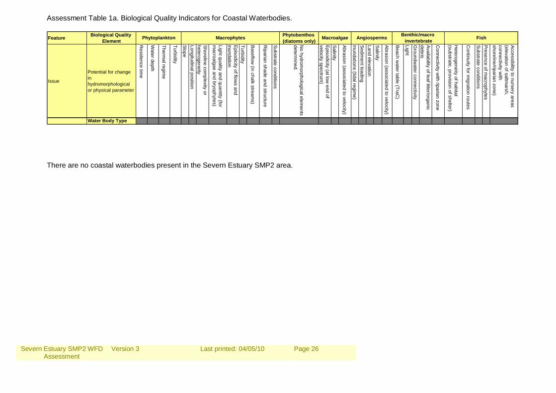
Assessment Table 1a. Biological Quality Indicators for Coastal Waterbodies. Feature Biological Quality
ElementPhytobenthos (diatoms only)
Issue
Potential for change in hydromorphological or physical parameter
Residence tim
e
Water depth
Thermal regim
e
Turbidity
SlopeLongitudinal position
Shoreline complexity or
heterogeneity
Light quality and quantity (for m
acroalgae and bryophytes)
Episodicity of flows and
inundation
Turbidity
Baseflow (in chalk stream
s)
Riparian shade and structure
Substrate conditions
No hydrom
orphological elements
determined.
Episodicity (at low end of
velocity spectrum)
Salinity
Abrasion (associated to velocity)
Inundations (tidal regime)
Sediment loading
Land elevationSalinity
Abrasion (associated to velocity)
Beach water table (TraC
)
LightG
roundwater connectivity
Availability of leaf litter/organic debris
Connectivity w
ith riparian zone
Heterogeneity of habitat
(substrate, provision of shelter)
Continuity for m
igration routes
Substrate conditionsPresence of m
acrophytes
Accessibility to nursery areas (elevation of saltm
arsh, connectivity w
ith shoreline/riparian zone)
Water Body Type
Benthic/macro invertebrate FishPhytoplankton Macrophytes Macroalgae Angiosperms
There are no coastal waterbodies present in the Severn Estuary SMP2 area.
Severn Estuary SMP2 WFD Assessment
Version 3
Last printed: 04/05/10
Page 27
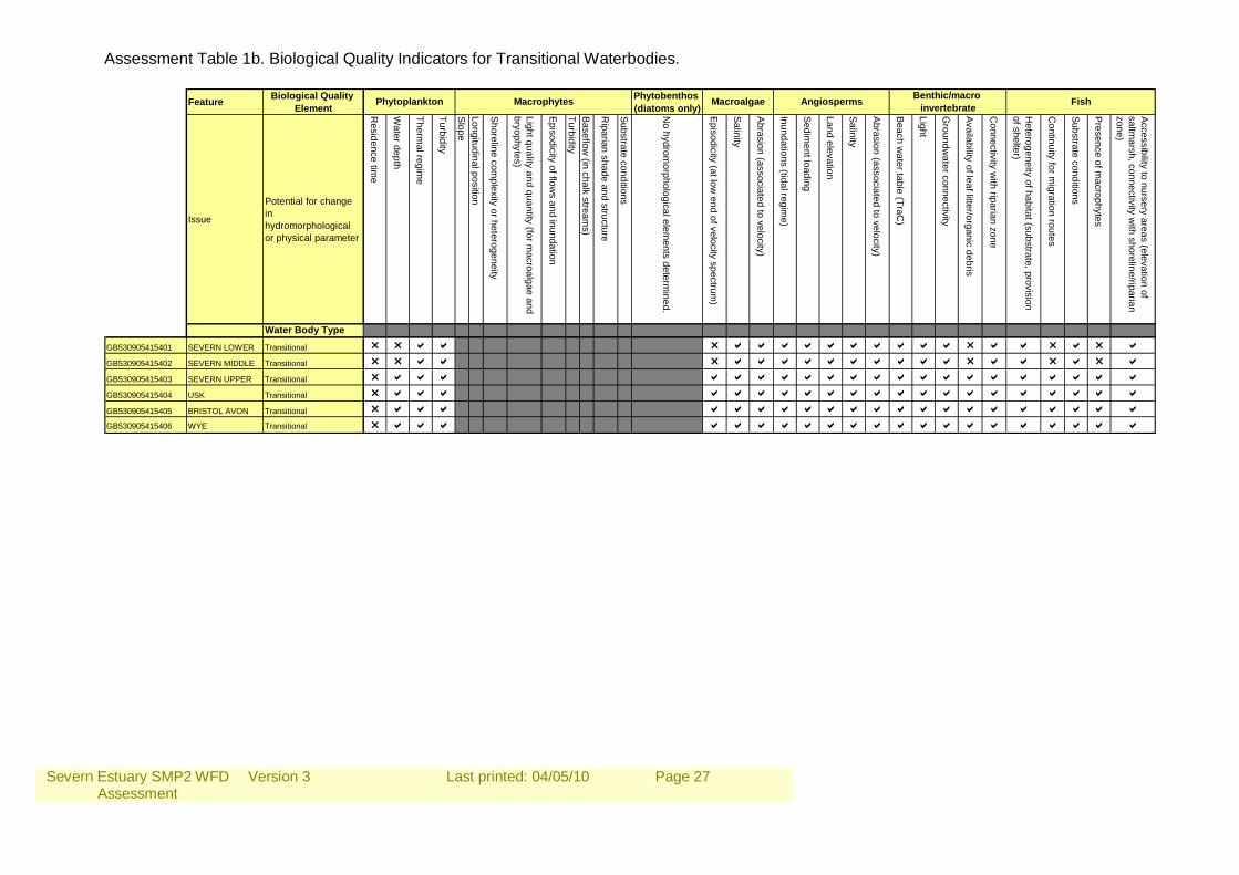
Assessment Table 1b. Biological Quality Indicators for Transitional Waterbodies.
Feature Biological Quality Element
Phytobenthos (diatoms only)
Issue
Potential for change in hydromorphological or physical parameter
Residence tim
e
Water depth
Thermal regim
e
Turbidity
SlopeLongitudinal position
Shoreline complexity or heterogeneity
Light quality and quantity (for macroalgae and
bryophytes)
Episodicity of flows and inundation
TurbidityBaseflow
(in chalk streams)
Riparian shade and structure
Substrate conditions
No hydrom
orphological elements determ
ined.
Episodicity (at low end of velocity spectrum
)
Salinity
Abrasion (associated to velocity)
Inundations (tidal regime)
Sediment loading
Land elevation
Salinity
Abrasion (associated to velocity)
Beach water table (TraC
)
Light
Groundw
ater connectivity
Availability of leaf litter/organic debris
Connectivity w
ith riparian zone
Heterogeneity of habitat (substrate, provision
of shelter)
Continuity for m
igration routes
Substrate conditions
Presence of macrophytes
Accessibility to nursery areas (elevation of saltm
arsh, connectivity with shoreline/riparian
zone)
Water Body Type
GB530905415401 SEVERN LOWER Transitional r r a a r a a a a a a a a a a r a a r a r aGB530905415402 SEVERN MIDDLE Transitional r r a a r a a a a a a a a a a r a a r a r aGB530905415403 SEVERN UPPER Transitional r a a a a a a a a a a a a a a a a a a a a aGB530905415404 USK Transitional r a a a a a a a a a a a a a a a a a a a a aGB530905415405 BRISTOL AVON Transitional r a a a a a a a a a a a a a a a a a a a a aGB530905415406 WYE Transitional r a a a a a a a a a a a a a a a a a a a a a
Benthic/macro invertebrate FishPhytoplankton Macrophytes Macroalgae Angiosperms
Severn Estuary SMP2 WFD Assessment
Version 3
Last printed: 04/05/10
Page 28
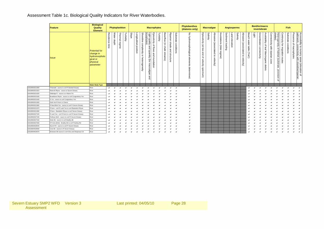
Assessment Table 1c. Biological Quality Indicators for River Waterbodies.
FeatureBiological
Quality Element
Phytobenthos (diatoms only)
Issue
Potential for change in hydromorphological or physical parameter
Residence tim
e
Water depth
Thermal regim
e
Turbidity
Slope
Longitudinal position
Shoreline com
plexity or heterogeneity
Light quality and quantity (for macroalgae and
bryophytes)
Episodicity of flow
s and inundation
Turbidity
Baseflow
(in chalk streams)
Riparian shade and structure
Substrate conditions
No hydrom
orphological elements determ
ined.
Episodicity (at low
end of velocity spectrum)
Salinity
Abrasion (associated to velocity)
Inundations (tidal regime)
Sedim
ent loading
Land elevation
Salinity
Abrasion (associated to velocity)
Beach w
ater table (TraC)
Light
Groundw
ater connectivity
Availability of leaf litter/organic debris
Connectivity w
ith riparian zone
Heterogeneity of habitat (substrate, provision of
shelter)
Continuity for m
igration routes
Substrate conditions
Presence of m
acrophytes
Accessibility to nursery areas (elevation of
saltmarsh, connectivity w
ith shoreline/riparian
Water Body TypeGB109052021600 R Banwell - source to conf R Banwell Estuary River a a a a a a a a a a a a a a a a a a a a a a a aGB109052021610 Redcroft Rhyne - source to Severn Estuary River a a a a a a a a a a a a a a a a a a a a a a a aGB109052021620 Oldbridge R - source to nr Manor Fm River a a a a a a a a a a a a a a a a a a a a a a a aGB109052021630 Broadstone Rhyne - source to conf Congresbury Yeo River a a a a a a a a a a a a a a a a a a a a a a a aGB109052021640 R Yeo - source to conf Congresbury Yeo River a a a a a a a a a a a a a a a a a a a a a a a aGB109052021650 Drain into R Kenn nr Cleeve River a a a a a a a a a a a a a a a a a a a a a a a aGB109052021660 R New Blind Yeo - source to conf R Severn Estuary River a a a a a a a a a a a a a a a a a a a a a a a aGB109052021670 R Kenn - conf R Land Yeo to conf Blackditch Rhyne River a a a a a a a a a a a a a a a a a a a a a a a aGB109052021680 R Kenn - Blackditch Rhyne to conf Severn Estuary River a a a a a a a a a a a a a a a a a a a a a a a aGB109052027320 R Land Yeo - conf R Kenn to conf R Severn Estuary River a a a a a a a a a a a a a a a a a a a a a a a aGB109052027330 Portbury Ditch - source to conf R Severn Estuary River a a a a a a a a a a a a a a a a a a a a a a a aGB109053027540 Stoke Bk - source to conf Bradley Bk River a a a a a a a a a a a a a a a a a a a a a a a aGB109053027840 R Frome (Brist) - Bradley Bk to conf Floating Hbr River a a a a a a a a a a a a a a a a a a a a a a a aGB109054026540 Sturch Pill - source to conf R Severn Estuary River a a a a a a a a a a a a a a a a a a a a a a a aGB109054026560 Cone Bk - source to R Severn Estuary River a a a a a a a a a a a a a a a a a a a a a a a aGB109054026570 Wicksters Bk source to conf Glos and Sharpness Cnl River a a a a a a a a a a a a a a a a a a a a a a a a
FishPhytoplankton Macrophytes Macroalgae Angiosperms Benthic/macro invertebrate
Severn Estuary SMP2 WFD Assessment
Version 3
Last printed: 04/05/10
Page 29
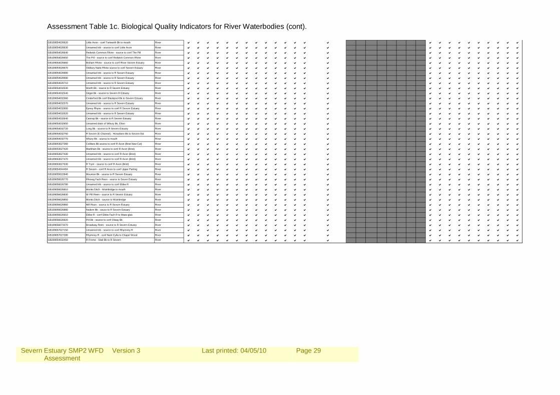
Assessment Table 1c. Biological Quality Indicators for River Waterbodies (cont). GB109054026620 Little Avon - conf Tortworth Bk to mouth River a a a a a a a a a a a a a a a a a a a a a a a aGB109054026630 Unnamed trib - source to conf Little Avon River a a a a a a a a a a a a a a a a a a a a a a a aGB109054026640 Redwick Common Rhine - source to conf The Pill River a a a a a a a a a a a a a a a a a a a a a a a aGB109054026650 The Pill - source to conf Redwick Common Rhine River a a a a a a a a a a a a a a a a a a a a a a a aGB109054026660 Bisham Rhine - source to conf RIver Severn Estuary River a a a a a a a a a a a a a a a a a a a a a a a aGB109054026670 Oldbury Naite Rhine source to conf Severn Estuary River a a a a a a a a a a a a a a a a a a a a a a a aGB109054026680 Unnamed trib - source to R Severn Estuary River a a a a a a a a a a a a a a a a a a a a a a a aGB109054026690 Unnamed trib - source to R Severn Estuary River a a a a a a a a a a a a a a a a a a a a a a a aGB109054026710 Unnamed trib - source to R Severn Estuary River a a a a a a a a a a a a a a a a a a a a a a a aGB109054032530 Warth Bk - source to R Severn Estuary River a a a a a a a a a a a a a a a a a a a a a a a aGB109054032540 Gilgal Bk - source to Severn R Estuary River a a a a a a a a a a a a a a a a a a a a a a a aGB109054032560 Cinderford Bk conf Blackpool Bk to Severn Estuary River a a a a a a a a a a a a a a a a a a a a a a a aGB109054032570 Unnamed trib - source to R Severn Estuary River a a a a a a a a a a a a a a a a a a a a a a a aGB109054032600 Epney Rhyne - source to conf R Severn Estuary River a a a a a a a a a a a a a a a a a a a a a a a aGB109054032620 Unnamed trib - source to R Severn Estuary River a a a a a a a a a a a a a a a a a a a a a a a aGB109054032640 Cannop Bk - source to R Severn Estuary River a a a a a a a a a a a a a a a a a a a a a a a aGB109054032650 Unnamed drain of Wbury Bk, Elton River a a a a a a a a a a a a a a a a a a a a a a a aGB109054032720 Long Bk - source to R Severn Estuary River a a a a a a a a a a a a a a a a a a a a a a a aGB109054032750 R Severn (E Channel) - Horsebere Bk to Severn Est River a a a a a a a a a a a a a a a a a a a a a a a aGB109054032770 Wbury Bk - source to mouth River a a a a a a a a a a a a a a a a a a a a a a a aGB109053027360 Colliters Bk source to conf R Avon (Brist New Cut) River a a a a a a a a a a a a a a a a a a a a a a a aGB109053027420 Markham Bk - source to conf R Avon (Brist) River a a a a a a a a a a a a a a a a a a a a a a a aGB109053027430 Unnamed trib - source to conf R Avon (Brist) River a a a a a a a a a a a a a a a a a a a a a a a aGB109053027470 Unnamed trib - source to conf R Avon (Brist) River a a a a a a a a a a a a a a a a a a a a a a a aGB109053027530 R Trym - source to conf R Avon (Brist) River a a a a a a a a a a a a a a a a a a a a a a a aGB109054044404 R Severn - conf R Avon to conf Upper Parting River a a a a a a a a a a a a a a a a a a a a a a a aGB109055022840 Mounton Bk - source to R Severn Estuary River a a a a a a a a a a a a a a a a a a a a a a a aGB109056026770 Rhosog Fach Reen - source to Seven Estuary River a a a a a a a a a a a a a a a a a a a a a a a aGB109056026780 Unnamed trib - source to conf Ebbw R River a a a a a a a a a a a a a a a a a a a a a a a aGB109056026810 Monks Ditch - Wainbridge to mouth River a a a a a a a a a a a a a a a a a a a a a a a aGB109056026830 W PIll Reen - source to R Severn Estuary River a a a a a a a a a a a a a a a a a a a a a a a aGB109056026850 Monks Ditch - source to Wainbridge River a a a a a a a a a a a a a a a a a a a a a a a aGB109056026860 Mill Reen - source to R Severn Estuary River a a a a a a a a a a a a a a a a a a a a a a a aGB109056026880 Nedern Bk - souce to R Severn Estuary River a a a a a a a a a a a a a a a a a a a a a a a aGB109056026910 Ebbw R - conf Ebbw Fach R to Maes-glas River a a a a a a a a a a a a a a a a a a a a a a a aGB109056026920 Pill Bk - source to conf Olway Bk River a a a a a a a a a a a a a a a a a a a a a a a aGB109056073370 Broadway Reen - source to R Severn Estuary River a a a a a a a a a a a a a a a a a a a a a a a aGB109057027150 Unnamed trib - source to conf Rhymney R River a a a a a a a a a a a a a a a a a a a a a a a aGB109057027280 Rhymney R - conf Nant Cylla to Chapel Wood River a a a a a a a a a a a a a a a a a a a a a a a aGB209054032450 R Frome - Slad Bk to R Severn River a a a a a a a a a a a a a a a a a a a a a a a a
Severn Estuary SMP2 WFD Assessment
Version 3
Last printed: 04/05/10
Page 30
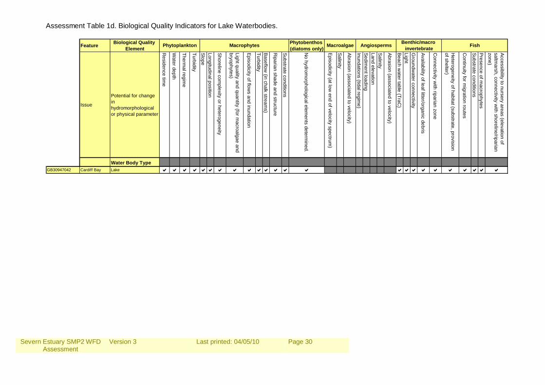
Assessment Table 1d. Biological Quality Indicators for Lake Waterbodies.
Feature Biological Quality Element
Phytobenthos (diatoms only)
Issue
Potential for change in hydromorphological or physical parameter
Residence tim
e
Water depth
Thermal regim
e
Turbidity
SlopeLongitudinal position
Shoreline complexity or heterogeneity
Light quality and quantity (for macroalgae and
bryophytes)
Episodicity of flows and inundation
TurbidityBaseflow
(in chalk streams)
Riparian shade and structure
Substrate conditions
No hydrom
orphological elements determ
ined.
Episodicity (at low end of velocity spectrum
)
Salinity
Abrasion (associated to velocity)
Inundations (tidal regime)
Sediment loading
Land elevationSalinity
Abrasion (associated to velocity)
Beach water table (TraC
)LightG
roundwater connectivity
Availability of leaf litter/organic debris
Connectivity w
ith riparian zone
Heterogeneity of habitat (substrate, provision
of shelter)
Continuity for m
igration routes
Substrate conditionsPresence of m
acrophytes
Accessibility to nursery areas (elevation of saltm
arsh, connectivity with shoreline/riparian
zone)
Water Body TypeGB30947042 Cardiff Bay Lake a a a aaa a a a aa a a a aaa a a a a aa a
Benthic/macro invertebrate FishPhytoplankton Macrophytes Macroalgae Angiosperms
Severn Estuary SMP2 WFD Assessment
Version 3
Last printed: 04/05/10
Page 31
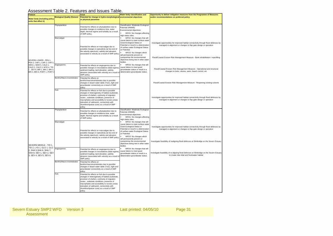
Assessment Table 2. Features and Issues Table. Issue
Water body (including policy units that affect it)
Biological Quality Element Potential for change in hydro-morphological or physical parameter
Classification: Moderate Ecological Potential (HMWB)Environmental objectives: WFD1: No changes affecting high status sites. WFD2: No changes that will cause failure to meet surface water Good Ecological Status or Potential or result in a deterioration of surface water Ecological Status or Potential. WFD3: No changes which will permanently prevent or compromise the environmental objectives being met in other water bodies.
Benthic/Macro invertebrates Potential for effects on benthic/macroinvertebrates due to possible changes in beach water table (TraC), light and groundwater connectivity as a result of SMP policy.
Fish Potential for effects on fish due to possible changes in heterogeneity of habitat (substrate, provision of shelter), continuity of migration routes , substrate conditions, presence of macrophytes and accesibility to nursery areas (elevation of saltmarsh, connectivity with shoreline/riparian zone) as a result of SMP policy.
SEVERN LOWER - PEN 1, PEN 2, CAR 1, CAR 2, CAR 3, WEN 1, NEW 5, CALD 1, CALD 2, CALD 3, WYE 4, TID 1 , SEV 6, BRI 1, BRI 2, BRI 3, BRI 4, BRI 6, PORT 1, PORT 2
Macroalgae
Potential for effects on macroalgae due to possible changes in episodicity (at low end of the velocity spectrum), salinity and abrasion associated to velocity as a result of SMP policy.
Angiosperms Potential for effects on angiosperms due to possible changes in innundations (tidal regime), sediment loading, land elevation, salinity, abrasion (associated with velocity) as a result of SMP policy.
Potential for effects on phytoplankton due to possible changes in residence time, water depth, thermal regime and turbidity as a result of SMP policy.
WFD4: No changes that will cause failure to meet good groundwater status or result in a deterioration groundwater status.
PhytoplanktonPotential for effects on phytoplankton due to possible changes in residence time, water depth, thermal regime and turbidity as a result of SMP policy.
SEVERN MIDDLE - TID 1, TID 2, LYD 1, GLO 1, GLO 2, SHA 5,SHA 6, SHA 7, SHA 8, SEV 1, SEV 2, SEV 3, SEV 4, SEV 5, SEV 6
Feature Water body classification and environmental objectives
Opportunity to deliver mitigation measures from the Programme of Measures and/or recommendations on preferred policy
Macroalgae
Potential for effects on macroalgae due to possible changes in episodicity (at low end of the velocity spectrum), salinity and abrasion associated to velocity as a result of SMP policy.
Angiosperms Potential for effects on angiosperms due to possible changes in innundations (tidal regime), sediment loading, land elevation, salinity, abrasion (associated with velocity) as a result of SMP policy.
WFD4: No changes that will cause failure to meet good groundwater status or result in a deterioration groundwater status.
Investigate feasibility of re-aligning flood defences at Slimbridge on the Severn Estuary to create inter-tidal and freshwater habitat
Investigate opportunities for improved habitat connectivity through flood defences by managed re-alignment or changes to flap gate design or operation
Investigate feasibility of realigning flood defences at Slimbridge on the Severn Estuary
Phytoplankton
Flood/Coastal Erosion Risk Management Measure - Reopening existing culverts
Investigate opportunities for improved habitat connectivity through flood defences by managed re-alignment or changes to flap gate design or operation
Flood/Coastal Erosion Risk Management Measure - Operational and structural changes to locks, sluices, weirs, beach control, etc
Investigate opportunities for improved habitat connectivity through flood defences by managed re-alignment or changes to flap gate design or operation
Flood/Coastal Erosion Risk Management Measure - Bank rehabilitation / reprofiling
Severn Estuary SMP2 WFD Assessment
Version 3
Last printed: 04/05/10
Page 32
Assessment Table 2. Features and Issues Table (cont). Classification: Moderate Ecological Potential (HMWB)Environmental objectives: WFD1: No changes affecting high status sites. WFD2: No changes that will cause failure to meet surface water Good Ecological Status or Potential or result in a deterioration of surface water Ecological Status or Potential. WFD3: No changes which will permanently prevent or compromise the environmental objectives being met in other water bodies.
Benthic/Macro invertebrates Potential for effects on benthic/macroinvertebrates due to possible changes in beach water table (TraC), light and groundwater connectivity as a result of SMP policy.
Fish Potential for effects on fish due to possible changes in heterogeneity of habitat (substrate, provision of shelter), continuity of migration routes , substrate conditions, presence of macrophytes and accesibility to nursery areas (elevation of saltmarsh, connectivity with shoreline/riparian zone) as a result of SMP policy.
Classification: Moderate Ecological Potential (HMWB)Environmental objectives: WFD1: No changes affecting high status sites. WFD2: No changes that will cause failure to meet surface water Good Ecological Status or Potential or result in a deterioration of surface water Ecological Status or Potential. WFD3: No changes which will permanently prevent or compromise the environmental objectives being met in other water bodies.
Benthic/Macro invertebrates Potential for effects on benthic/macroinvertebrates due to possible changes in beach water table (TraC), light and groundwater connectivity as a result of SMP policy.
Fish Potential for effects on fish due to possible changes in heterogeneity of habitat (substrate, provision of shelter), continuity of migration routes , substrate conditions, presence of macrophytes and accesibility to nursery areas (elevation of saltmarsh, connectivity with shoreline/riparian zone) as a result of SMP policy.
Provision of best practice advice and guidance to riparian owners to reduce the impact of aggregate extraction from Rivers Wye and Usk Special Areas of Conservation in
Wales through the River Aggregates Sustainability Project (RASP)
Promote Code for Sustainable Homes (now mandatory Level 3 for all residential developments greater than 4 dwellings) and BREEAM standards in national planning
policy in Wales
Establish and maintain a nationally (Wales) funded advice-led programme under the Environment Agency Wales Catchment Initiatives to influence land management to
bring about changes in practice that are likely to impact on water quality and achieve multiple outcomes – integrating diffuse pollution mitigation with habitat creation,
localised flood risk and fisheries issues
Macroalgae
Potential for effects on macroalgae due to possible changes in episodicity (at low end of the velocity spectrum), salinity and abrasion associated to velocity as a result of SMP policy.
PhytoplanktonPotential for effects on phytoplankton due to possible changes in residence time, water depth, thermal regime and turbidity as a result of SMP policy.
Angiosperms Potential for effects on angiosperms due to possible changes in innundations (tidal regime), sediment loading, land elevation, salinity, abrasion (associated with velocity) as a result of SMP policy.
WFD4: No changes that will cause failure to meet good groundwater status or result in a deterioration groundwater status.
PhytoplanktonPotential for effects on phytoplankton due to possible changes in residence time, water depth, thermal regime and turbidity as a result of SMP policy.
Macroalgae
Potential for effects on macroalgae due to possible changes in episodicity (at low end of the velocity spectrum), salinity and abrasion associated to velocity as a result of SMP policy.
SEVERN UPPER - GLO 2, GLO3, GLO 4, GLO 5, GLO 6, GLO 7, GLO 8, MAI 1, MAI 2, MAI 3, MAI 4, MAI 5, MAI 6, SHA 1, SHA 2, SHA 3, SHA 4, SHA 5
USK - NEW 1, NEW 2, NEW 3, NEW 4, NEW 5, CALD 1
Assess eel populations in the Caldicot and Wentlooge Reen system
Maintain and improve eel passage at identified obstructions on Severn, Wye, Usk, Taff and Lyd
EU Fisheries Fund project to reduce local impacts of acidification by continuing long term programme of catchment liming, easements for fish passage and habitat
restoration
Develop and deliver a comprehensive programme of improvements to or removal of Environment Agency owned weirs which are the most significant physical barriers to
fish passage. The best solution will be identified on a site by site basis
Flood/Coastal Erosion Risk Management Measure - Bank rehabilitation / reprofiling
Investigate opportunities for improved habitat connectivity through flood defences by managed re-alignment or changes to flap gate design or operation
Investigate opportunities for improved habitat connectivity through flood defences by managed re-alignment or changes to flap gate design or operation
Flood/Coastal Erosion Risk Management Measure - Reopening existing culverts
Flood/Coastal Erosion Risk Management Measure - Operational and structural changes to locks, sluices, weirs, beach control, etc
Severn Estuary SMP2 WFD Assessment
Version 3
Last printed: 04/05/10
Page 33
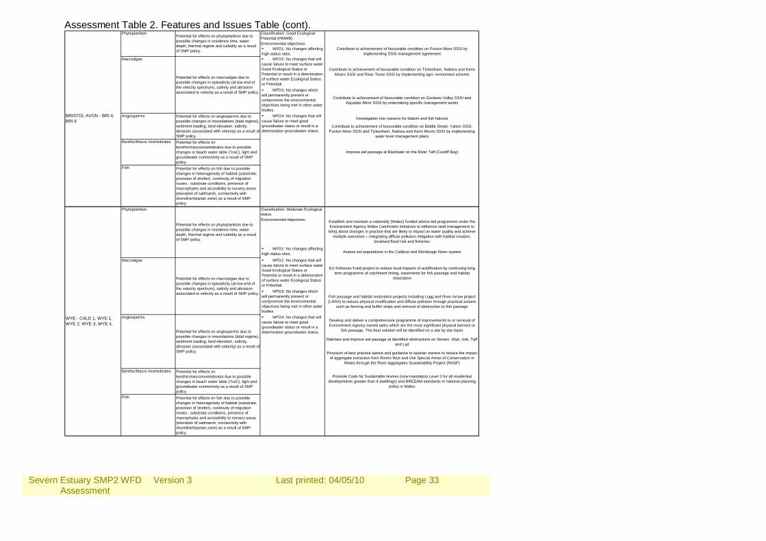
Assessment Table 2. Features and Issues Table (cont). Classification: Good Ecological Potential (HMWB)Environmental objectives: WFD1: No changes affecting high status sites. WFD2: No changes that will cause failure to meet surface water Good Ecological Status or Potential or result in a deterioration of surface water Ecological Status or Potential. WFD3: No changes which will permanently prevent or compromise the environmental objectives being met in other water bodies.
Benthic/Macro invertebrates Potential for effects on benthic/macroinvertebrates due to possible changes in beach water table (TraC), light and groundwater connectivity as a result of SMP policy.
Fish Potential for effects on fish due to possible changes in heterogeneity of habitat (substrate, provision of shelter), continuity of migration routes , substrate conditions, presence of macrophytes and accesibility to nursery areas (elevation of saltmarsh, connectivity with shoreline/riparian zone) as a result of SMP policy.
Classification: Moderate Ecological statusEnvironmental objectives:
WFD1: No changes affecting high status sites.
WFD2: No changes that will cause failure to meet surface water Good Ecological Status or Potential or result in a deterioration of surface water Ecological Status or Potential. WFD3: No changes which will permanently prevent or compromise the environmental objectives being met in other water bodies.
Benthic/Macro invertebrates Potential for effects on benthic/macroinvertebrates due to possible changes in beach water table (TraC), light and groundwater connectivity as a result of SMP policy.
Fish Potential for effects on fish due to possible changes in heterogeneity of habitat (substrate, provision of shelter), continuity of migration routes , substrate conditions, presence of macrophytes and accesibility to nursery areas (elevation of saltmarsh, connectivity with shoreline/riparian zone) as a result of SMP policy.
Contribute to achievement of favourable condition on Puxton Moor SSSI by implementing SSSI management agreement
Contribute to achievement of favourable condition on Tickenham, Nailsea and Kenn Moors SSSI and River Teme SSSI by implementing agri- nvironment scheme
Contribute to achievement of favourable condition on Gordano Valley SSSI and Aqualate Mere SSSI by undertaking specific management works
Investigation into reasons for diatom and fish failures
Contribute to achievement of favourable condition on Biddle Street, Yatton SSSI, Puxton Moor SSSI and Tickenham, Nailsea and Kenn Moors SSSI by implementing
water level management plans
Improve eel passage at Blackweir on the River Taff (Cardiff Bay)
WFD4: No changes that will cause failure to meet good groundwater status or result in a deterioration groundwater status.
PhytoplanktonPotential for effects on phytoplankton due to possible changes in residence time, water depth, thermal regime and turbidity as a result of SMP policy.
Macroalgae
Potential for effects on macroalgae due to possible changes in episodicity (at low end of the velocity spectrum), salinity and abrasion associated to velocity as a result of SMP policy.
Angiosperms Potential for effects on angiosperms due to possible changes in innundations (tidal regime), sediment loading, land elevation, salinity, abrasion (associated with velocity) as a result of SMP policy.
WFD4: No changes that will cause failure to meet good groundwater status or result in a deterioration groundwater status.
Phytoplankton
Potential for effects on phytoplankton due to possible changes in residence time, water depth, thermal regime and turbidity as a result of SMP policy.
Macroalgae
Potential for effects on macroalgae due to possible changes in episodicity (at low end of the velocity spectrum), salinity and abrasion associated to velocity as a result of SMP policy.
Angiosperms
Potential for effects on angiosperms due to possible changes in innundations (tidal regime), sediment loading, land elevation, salinity, abrasion (associated with velocity) as a result of SMP policy.
WYE - CALD 1, WYE 1, WYE 2, WYE 3, WYE 4,
BRISTOL AVON - BRI 4, BRI 6
Promote Code for Sustainable Homes (now mandatory Level 3 for all residential developments greater than 4 dwellings) and BREEAM standards in national planning
policy in Wales
Establish and maintain a nationally (Wales) funded advice-led programme under the Environment Agency Wales Catchment Initiatives to influence land management to
bring about changes in practice that are likely to impact on water quality and achieve multiple outcomes – integrating diffuse pollution mitigation with habitat creation,
localised flood risk and fisheries
Assess eel populations in the Caldicot and Wentlooge Reen system
Maintain and improve eel passage at identified obstructions on Severn, Wye, Usk, Taff and Lyd
Provision of best practice advice and guidance to riparian owners to reduce the impact of aggregate extraction from Rivers Wye and Usk Special Areas of Conservation in
Wales through the River Aggregates Sustainability Project (RASP)
Develop and deliver a comprehensive programme of improvements to or removal of Environment Agency owned weirs which are the most significant physical barriers to
fish passage. The best solution will be identified on a site by site basis
EU Fisheries Fund project to reduce local impacts of acidification by continuing long term programme of catchment liming, easements for fish passage and habitat
restoration
Fish passage and habitat restoration projects including Lugg and River Arrow project (LARA) to reduce physical modification and diffuse pollution through practical actions
such as fencing and buffer strips and removal of obstruction to fish passage
Severn Estuary SMP2 WFD Assessment
Version 3
Last printed: 04/05/10
Page 34
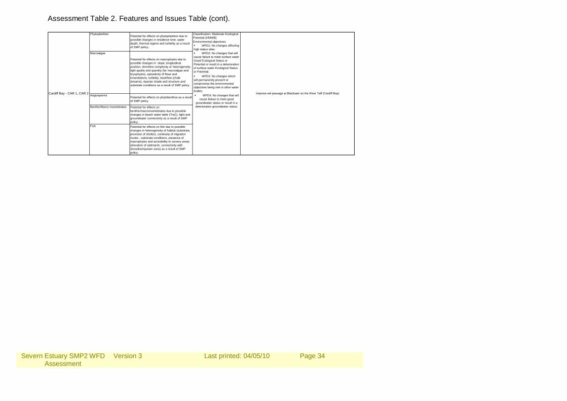
Assessment Table 2. Features and Issues Table (cont).
Classification: Moderate Ecological Potential (HMWB)Environmental objectives: WFD1: No changes affecting high status sites. WFD2: No changes that will cause failure to meet surface water Good Ecological Status or Potential or result in a deterioration of surface water Ecological Status or Potential. WFD3: No changes which will permanently prevent or compromise the environmental objectives being met in other water bodies.
Benthic/Macro invertebrates Potential for effects on benthic/macroinvertebrates due to possible changes in beach water table (TraC), light and groundwater connectivity as a result of SMP policy.
Fish Potential for effects on fish due to possible changes in heterogeneity of habitat (substrate, provision of shelter), continuity of migration routes , substrate conditions, presence of macrophytes and accesibility to nursery areas (elevation of saltmarsh, connectivity with shoreline/riparian zone) as a result of SMP policy.
WFD4: No changes that will cause failure to meet good
groundwater status or result in a deterioration groundwater status.
Cardiff Bay - CAR 1, CAR 2 Improve eel passage at Blackweir on the River Taff (Cardiff Bay)
Macroalgae
Potential for effects on macrophytes due to possible changes in slope, longitudinal position, shoreline complexity or heterogeneity, light qaulity and quantity (for macroalgae and bryophytes), episodicity of flows and innundations, turbidity, baseflow (chalk streams), riparian shade and structure and substrate conditions as a result of SMP policy.
Angiosperms Potential for effects on phytobenthos as a result of SMP policy.
PhytoplanktonPotential for effects on phytoplankton due to possible changes in residence time, water depth, thermal regime and turbidity as a result of SMP policy.
Severn Estuary SMP2 WFD Assessment
Version 3
Last printed: 04/05/10
Page 35
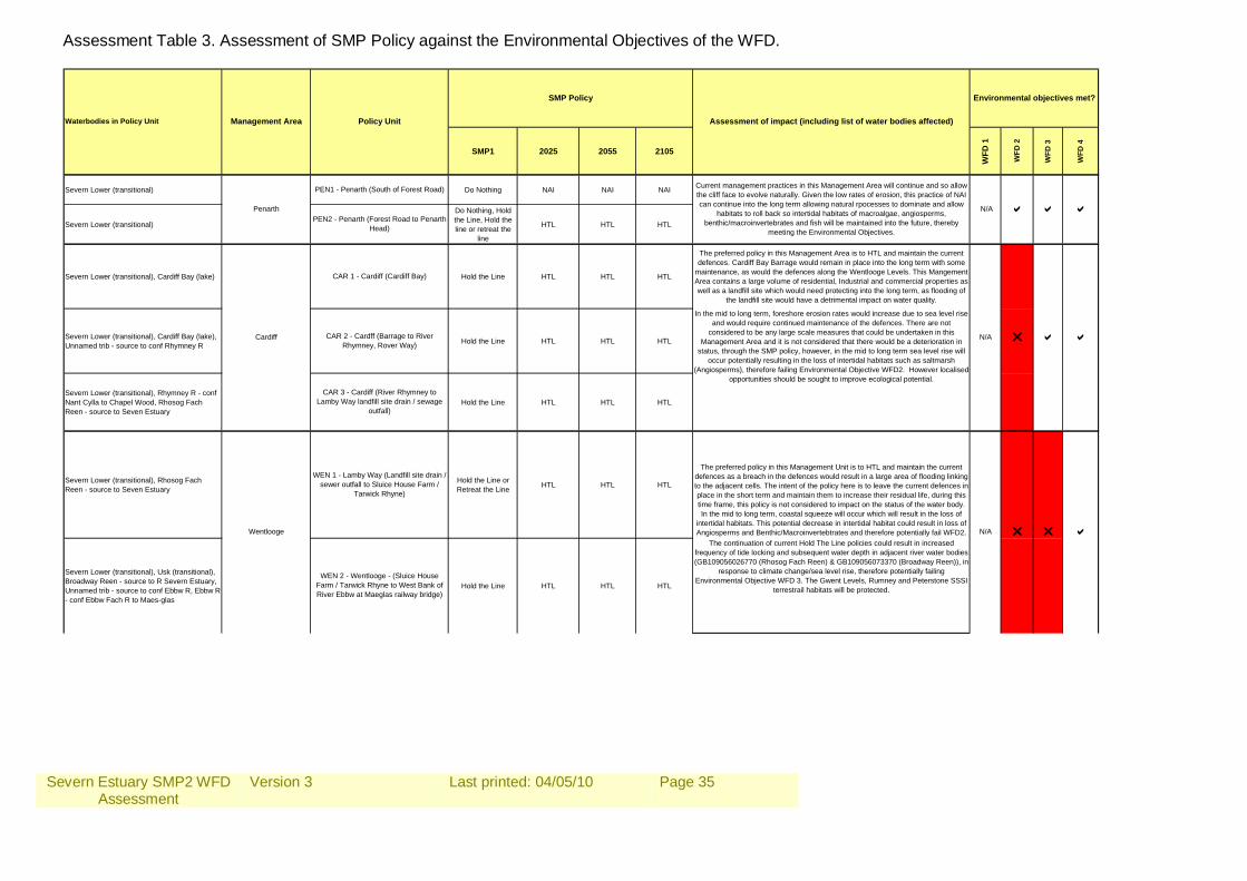
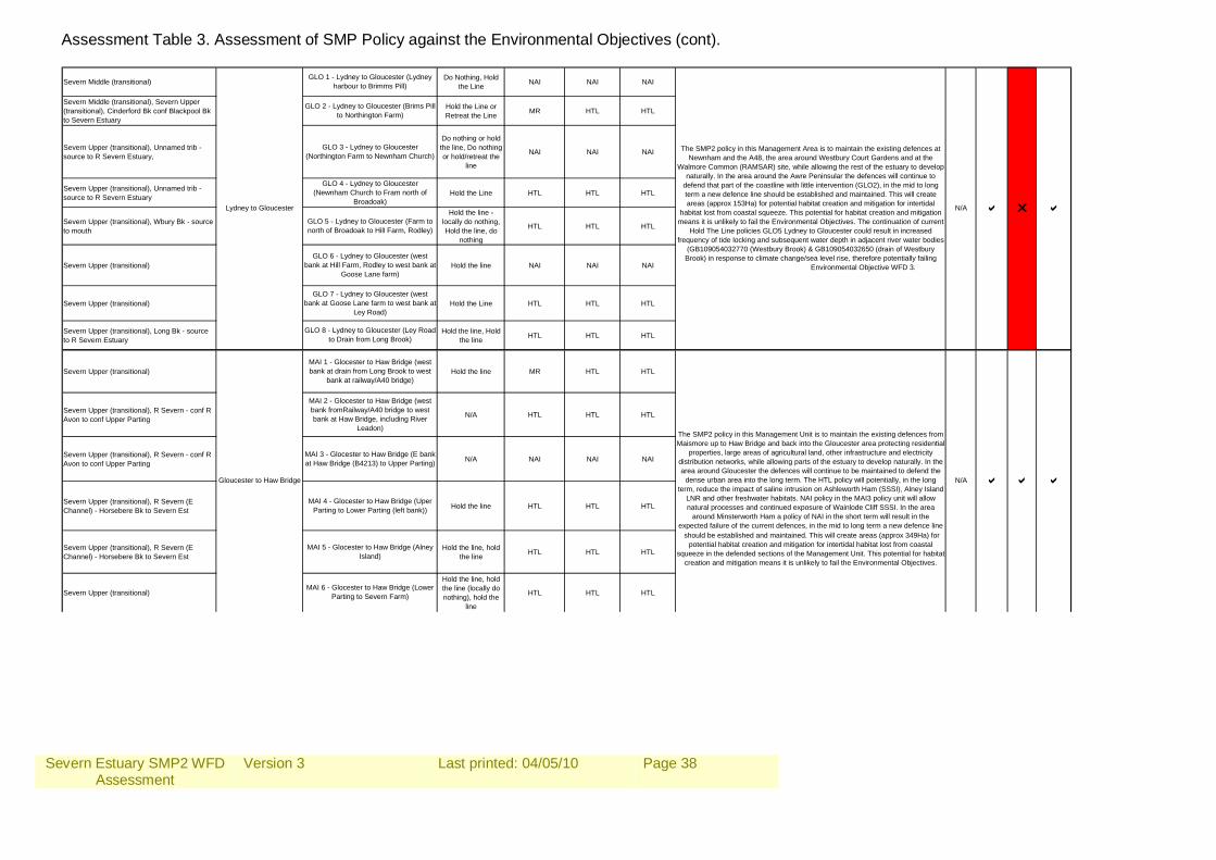
Assessment Table 3. Assessment of SMP Policy against the Environmental Objectives of the WFD.
SMP1 2025 2055 2105
WFD
1
WFD
3
WFD
4
Severn Lower (transitional) Do Nothing NAI NAI NAI
Severn Lower (transitional)
Do Nothing, Hold the Line, Hold the line or retreat the
line
HTL HTL HTL
Severn Lower (transitional), Cardiff Bay (lake) Hold the Line HTL HTL HTL
The preferred policy in this Management Area is to HTL and maintain the current defences. Cardiff Bay Barrage would remain in place into the long term with some
maintenance, as would the defences along the Wentlooge Levels. This Mangement Area contains a large volume of residential, Industrial and commercial properties as well as a landfill site which would need protecting into the long term, as flooding of
the landfill site would have a detrimental impact on water quality.
Severn Lower (transitional), Cardiff Bay (lake), Unnamed trib - source to conf Rhymney R Hold the Line HTL HTL HTL
Severn Lower (transitional), Rhymney R - conf Nant Cylla to Chapel Wood, Rhosog Fach Reen - source to Seven Estuary
Hold the Line HTL HTL HTL
Severn Lower (transitional), Rhosog Fach Reen - source to Seven Estuary
Hold the Line or Retreat the Line HTL HTL HTL
The preferred policy in this Management Unit is to HTL and maintain the current defences as a breach in the defences would result in a large area of flooding linking to the adjacent cells. The intent of the policy here is to leave the current defences in place in the short term and maintain them to increase their residual life, during this time frame, this policy is not considered to impact on the status of the water body. In the mid to long term, coastal squeeze will occur which will result in the loss of
intertidal habitats. This potential decrease in intertidal habitat could result in loss of Angiosperms and Benthic/Macroinvertebtrates and therefore potentially fail WFD2.
Severn Lower (transitional), Usk (transitional), Broadway Reen - source to R Severn Estuary, Unnamed trib - source to conf Ebbw R, Ebbw R - conf Ebbw Fach R to Maes-glas
Hold the Line HTL HTL HTL
The continuation of current Hold The Line policies could result in increased frequency of tide locking and subsequent water depth in adjacent river water bodies (GB109056026770 (Rhosog Fach Reen) & GB109056073370 (Broadway Reen)), in
response to climate change/sea level rise, therefore potentially failing Environmental Objective WFD 3. The Gwent Levels, Rumney and Peterstone SSSI
terrestrail habitats will be protected.
In the mid to long term, foreshore erosion rates would increase due to sea level rise and would require continued maintenance of the defences. There are not
considered to be any large scale measures that could be undertaken in this Management Area and it is not considered that there would be a deterioration in
status, through the SMP policy, however, in the mid to long term sea level rise will occur potentially resulting in the loss of intertidal habitats such as saltmarsh
(Angiosperms), therefore failing Environmental Objective WFD2. However localised opportunities should be sought to improve ecological potential.
N/A r r a
N/A r a a
N/A a a a
WEN 1 - Lamby Way (Landfill site drain / sewer outfall to Sluice House Farm /
Tarwick Rhyne)
WEN 2 - Wentlooge - (Sluice House Farm / Tarwick Rhyne to West Bank of River Ebbw at Maeglas railway bridge)
Waterbodies in Policy Unit
Current management practices in this Management Area will continue and so allow the cliff face to evolve naturally. Given the low rates of erosion, this practice of NAI can continue into the long term allowing natural rpocesses to dominate and allow
habitats to roll back so intertidal habitats of macroalgae, angiosperms, benthic/macroinvertebrates and fish will be maintained into the future, thereby
meeting the Environmental Objectives.
PEN1 - Penarth (South of Forest Road)
PEN2 - Penarth (Forest Road to Penarth Head)
CAR 1 - Cardiff (Cardiff Bay)
CAR 2 - Cardff (Barrage to River Rhymney, Rover Way)
CAR 3 - Cardiff (River Rhymney to Lamby Way landfill site drain / sewage
outfall)
Management Area
Penarth
Cardiff
SMP Policy
Assessment of impact (including list of water bodies affected)
Environmental objectives met?
WFD
2
Policy Unit
Wentlooge
Severn Estuary SMP2 WFD Assessment
Version 3
Last printed: 04/05/10
Page 36
Assessment Table 3. Assessment of SMP Policy against the Environmental Objectives (cont).
Usk (transitional) Hold the Line HTL HTL HTL
Usk (transitional) Hold the Line HTL HTL HTL
Usk (transitional) Hold the Line NAI NAI MR
Usk (transitional) HTL HTL HTL
Severn Lower (transitional), Usk (transitional), Monks Ditch - source to Wainbridge Hold the Line HTL HTL HTL
Severn Lower (transitional), Monks Ditch - source to Wainbridge, Monks Ditch - Wainbridge to mouth, Mill Reen - source to R Severn Estuary, W PIll Reen - source to R Severn Estuary, Nedern Bk - souce to R Severn Estuary
Hold the Line HTL HTL HTL
Severn Lower (transitional) Do nothing, locally Hold the Line NAI NAI NAI
Severn Lower (transitional), Wye (transitional), Mounton Bk - source to R Severn Estuary
Do nothing, locally Hold the Line or Retrat the Line
HTL HTL HTL
The continuation of current Hold The Line policies could result in increased frequency of tide locking and subsequent water depth in adjacent river water bodies (GB109056026850 (Monks ditch source to Wainbridge), GB109056026810 (Monks
Ditch Wainbridge to Mouth), GB109056026860 (Mill Reen), GB109056026880 (Nedern Brook), GB109055022840 (Mounton Brook)), in response to climate
change/sea level rise, therefore potentially failing Environmental Objective WFD 3.
The aim in this Management Area is to protect the Caldicott Levels, which are an important agricultural asset, Uskmouth Poer Station, the Llanwern Steelworks, the M4 crossing and areas of Newport and Magor. In order to do this a HTL policy is proposed in the majority of this area with a small section of NAI around Sudbrook
where high ground prdominates and no intervention is required. The existing defences are expected to be replaced in the short term, prior to failure and be
maintained into the long term. In the short term, a HTL policy will not impact on the waterbody status as no new large scale measures are to be undertaken, instead a defence line will be maintained in its current position. Into the mid and long terms
sea level rise will result in the potential loss of intertidal habitats as they are submerged and the defences and high ground prevent roll back. This has the
potential to impact on Angiosperms and Fish (through the loss of feeding grounds and benthic/Macroinvertebrates) and therefore fail Environmental Objective WFD2.
Newport and Usk
Caldicott Levels
CALD 3 - (Black Rock at Black Rock Road to west bank of River Wye at Park
Redding, Thornwell)
NEW 4?
NEW 5 - Spytty Pill (north of A48 crossing to Uskmouth power station
point)
CALD 1 - Caldicott (Uskmouth power station point to Sudbrook Point, north of
M4 Severn Crossing)
CALD 2 - Sudbrook Point (north of M4 Severn Crossing to Black Rock at Black
Rock Road)
The preferred policy for much of this Management Area is to HTL into the long term. This Management Area contains the nationally important Newport Docks which are
currently protected by earth embankments. In the short term these banks are expected to fail, but should be reconstructed and a maintenance regime put in
place to maintain them into the long term. In the long term, natural processes of the river may result in meandering of the channel, potentially increasing the
hydromorphological diversity. For the majority of this Management Area, a HTL policy will not impact the nature conservation sites, however, into the mid to long
term, sea level rise will occur and coastal squeeze will result in the loss of intertidal habitat. In the area around Newbridge to the M4 crossing, NAI on the current
defences will mean that they remain in place in the short term, but are expected to fail in the mid to long term and a realigned defence line will be established to prevent increased flood risk. This Managed Realignment in the long term may
benefit the Ecological Status of the waterbody increasing the amount of intertidal habitats for macroalgae, angiosperms, benthic/macroinvertebrates and fish and
allowing for replacement of lost habitats due to sea level rise, supporting the Environmental Objectives, but will affect the habitats and features of the Usk SAC
and Lower River Usk SSSI.
NEW 1 - Newport (East bank of Ebbw at Maesglas railway bridge to west bank
Usk at transporter bridge)
NEW 2 - Newport (West bank of Usk at transporter bridge to west bank of Usk at
M4 crossing)
NEW 3 - Usk (both banks at M4 crossing to Newbridge on Usk)
N/A a a a
N/A r r a
Severn Estuary SMP2 WFD Assessment
Version 3
Last printed: 04/05/10
Page 37
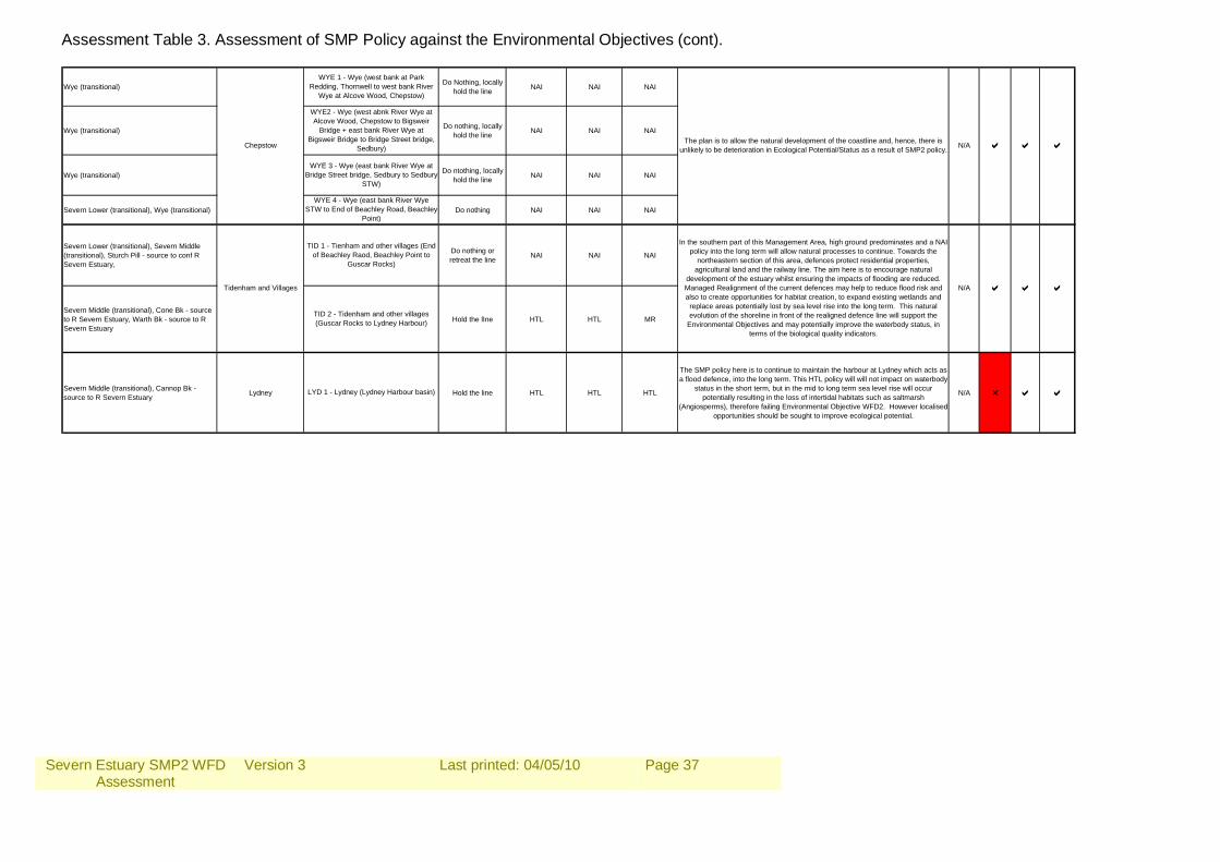
Assessment Table 3. Assessment of SMP Policy against the Environmental Objectives (cont). Wye (transitional) Do Nothing, locally
hold the line NAI NAI NAI
Wye (transitional) Do nothing, locally hold the line NAI NAI NAI
Wye (transitional) Do ntothing, locally hold the line NAI NAI NAI
Severn Lower (transitional), Wye (transitional) Do nothing NAI NAI NAI
Severn Lower (transitional), Severn Middle (transitional), Sturch Pill - source to conf R Severn Estuary,
Do nothing or retreat the line NAI NAI NAI
Severn Middle (transitional), Cone Bk - source to R Severn Estuary, Warth Bk - source to R Severn Estuary
Hold the lIne HTL HTL MR
Severn Middle (transitional), Cannop Bk - source to R Severn Estuary Lydney Hold the line HTL HTL HTL
The SMP policy here is to continue to maintain the harbour at Lydney which acts as a flood defence, into the long term. This HTL policy will will not impact on waterbody
status in the short term, but in the mid to long term sea level rise will occur potentially resulting in the loss of intertidal habitats such as saltmarsh
(Angiosperms), therefore failing Environmental Objective WFD2. However localised opportunities should be sought to improve ecological potential.
N/A r a a
Chepstow
Tidenham and Villages
WYE 4 - Wye (east bank River Wye STW to End of Beachley Road, Beachley
Point)
TID 1 - Tienham and other villages (End of Beachley Raod, Beachley Point to
Guscar Rocks)
TID 2 - Tidenham and other villages (Guscar Rocks to Lydney Harbour)
LYD 1 - Lydney (Lydney Harbour basin)
WYE 3 - Wye (east bank River Wye at Bridge Street bridge, Sedbury to Sedbury
STW)
WYE 1 - Wye (west bank at Park Redding, Thornwell to west bank River
Wye at Alcove Wood, Chepstow)
WYE2 - Wye (west abnk River Wye at Alcove Wood, Chepstow to Bigsweir
Bridge + east bank River Wye at Bigsweir Bridge to Bridge Street bridge,
Sedbury)The plan is to allow the natural development of the coastline and, hence, there is
unlikely to be deterioration in Ecological Potential/Status as a result of SMP2 policy.
In the southern part of this Management Area, high ground predominates and a NAI policy into the long term will allow natural processes to continue. Towards the
northeastern section of this area, defences protect residential properties, agricultural land and the railway line. The aim here is to encourage natural
development of the estuary whilst ensuring the impacts of flooding are reduced. Managed Realignment of the current defences may help to reduce flood risk and also to create opportunities for habitat creation, to expand existing wetlands and
replace areas potentially lost by sea level rise into the long term. This natural evolution of the shoreline in front of the realigned defence line will support the
Environmental Objectives and may potentially improve the waterbody status, in terms of the biological quality indicators.
N/A a a a
N/A a a a
Severn Estuary SMP2 WFD Assessment
Version 3
Last printed: 04/05/10
Page 38
Assessment Table 3. Assessment of SMP Policy against the Environmental Objectives (cont). Severn Middle (transitional) Do Nothing, Hold
the Line NAI NAI NAI
Severn Middle (transitional), Severn Upper (transitional), Cinderford Bk conf Blackpool Bk to Severn Estuary
Hold the Line or Retreat the Line MR HTL HTL
Severn Upper (transitional), Unnamed trib - source to R Severn Estuary,
Do nothing or hold the line, Do nothing or hold/retreat the
line
NAI NAI NAI
Severn Upper (transitional), Unnamed trib - source to R Severn Estuary Hold the Line HTL HTL HTL
Severn Upper (transitional), Wbury Bk - source to mouth
Hold the line - locally do nothing, Hold the line, do
nothing
HTL HTL HTL
Severn Upper (transitional) Hold the line NAI NAI NAI
Severn Upper (transitional) Hold the Line HTL HTL HTL
Severn Upper (transitional), Long Bk - source to R Severn Estuary
Hold the line, Hold the line HTL HTL HTL
Severn Upper (transitional) Hold the line MR HTL HTL
Severn Upper (transitional), R Severn - conf R Avon to conf Upper Parting N/A HTL HTL HTL
Severn Upper (transitional), R Severn - conf R Avon to conf Upper Parting N/A NAI NAI NAI
Severn Upper (transitional), R Severn (E Channel) - Horsebere Bk to Severn Est Hold the line HTL HTL HTL
Severn Upper (transitional), R Severn (E Channel) - Horsebere Bk to Severn Est
Hold the line, hold the line HTL HTL HTL
Severn Upper (transitional)
Hold the line, hold the line (locally do nothing), hold the
line
HTL HTL HTL
should be established and maintained. This will create areas (approx 349Ha) for potential habitat creation and mitigation for intertidal habitat lost from coastal
squeeze in the defended sections of the Management Unit. This potential for habitat creation and mitigation means it is unlikely to fail the Environmental Objectives.
The SMP2 policy in this Management Unit is to maintain the existing defences from Maismore up to Haw Bridge and back into the Gloucester area protecting residential
properties, large areas of agricultural land, other infrastructure and electricity distribution networks, while allowing parts of the estuary to develop naturally. In the area around Gloucester the defences will continue to be maintained to defend the
dense urban area into the long term. The HTL policy will potentially, in the long term, reduce the impact of saline intrusion on Ashleworth Ham (SSSI), Alney Island
LNR and other freshwater habitats. NAI policy in the MAI3 policy unit will allow natural processes and continued exposure of Wainlode Cliff SSSI. In the area
around Minsterworth Ham a policy of NAI in the short term will result in the expected failure of the current defences, in the mid to long term a new defence line
Lydney to Gloucester
Gloucester to Haw Bridge
MAI 5 - Glocester to Haw Bridge (Alney Island)
MAI 6 - Glocester to Haw Bridge (Lower Parting to Severn Farm)
MAI 1 - Glocester to Haw Bridge (west bank at drain from Long Brook to west
bank at railway/A40 bridge)
MAI 2 - Glocester to Haw Bridge (west bank fromRailway/A40 bridge to west bank at Haw Bridge, including River
Leadon)
MAI 3 - Glocester to Haw Bridge (E bank at Haw Bridge (B4213) to Upper Parting)
MAI 4 - Glocester to Haw Bridge (Uper Parting to Lower Parting (left bank))
GLO 5 - Lydney to Gloucester (Farm to north of Broadoak to Hill Farm, Rodley)
GLO 6 - Lydney to Gloucester (west bank at Hill Farm, Rodley to west bank at
Goose Lane farm)
GLO 7 - Lydney to Gloucester (west bank at Goose Lane farm to west bank at
Ley Road)
GLO 8 - Lydney to Gloucester (Ley Road to Drain from Long Brook)
GLO 1 - Lydney to Gloucester (Lydney harbour to Brimms Pill)
GLO 2 - Lydney to Gloucester (Brims Pill to Northington Farm)
GLO 3 - Lydney to Gloucester (Northington Farm to Newnham Church)
GLO 4 - Lydney to Gloucester (Newnham Church to Fram north of
Broadoak)
The SMP2 policy in this Management Area is to maintain the existing defences at Newnham and the A48, the area around Westbury Court Gardens and at the
Walmore Common (RAMSAR) site, while allowing the rest of the estuary to develop naturally. In the area around the Awre Peninsular the defences will continue to
defend that part of the coastline with little intervention (GLO2), in the mid to long term a new defence line should be established and maintained. This will create areas (approx 153Ha) for potential habitat creation and mitigation for intertidal
habitat lost from coastal squeeze. This potential for habitat creation and mitigation means it is unlikely to fail the Environmental Objectives. The continuation of current
Hold The Line policies GLO5 Lydney to Gloucester could result in increased frequency of tide locking and subsequent water depth in adjacent river water bodies
(GB109054032770 (Westbury Brook) & GB109054032650 (drain of Westbury Brook) in response to climate change/sea level rise, therefore potentially failing
Environmental Objective WFD 3.
a a
N/A a r a
N/A a
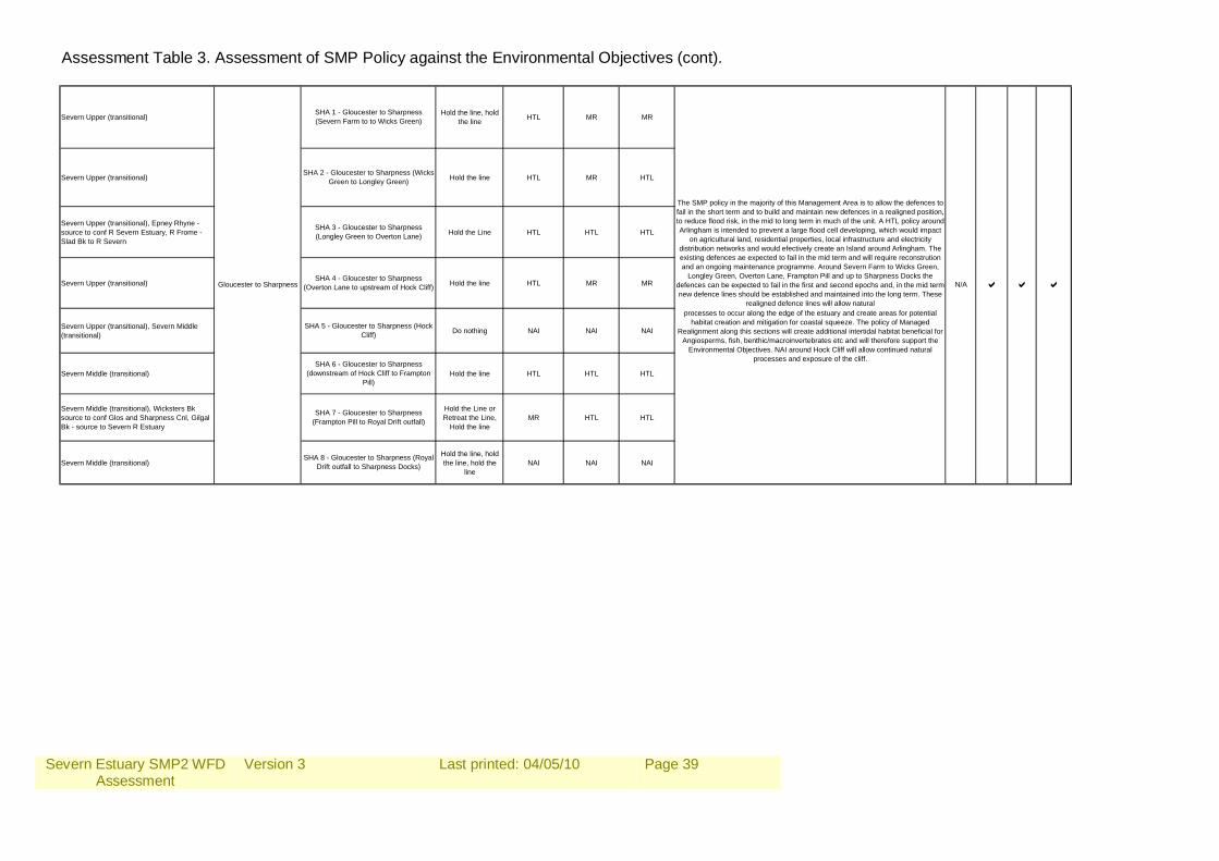
Severn Estuary SMP2 WFD Assessment
Version 3
Last printed: 04/05/10
Page 39
Assessment Table 3. Assessment of SMP Policy against the Environmental Objectives (cont).
Severn Upper (transitional) Hold the line, hold the line HTL MR MR
Severn Upper (transitional) Hold the line HTL MR HTL
Severn Upper (transitional), Epney Rhyne - source to conf R Severn Estuary, R Frome - Slad Bk to R Severn
Hold the Line HTL HTL HTL
Severn Upper (transitional) Hold the line HTL MR MR
Severn Upper (transitional), Severn Middle (transitional) Do nothing NAI NAI NAI
Severn Middle (transitional) Hold the line HTL HTL HTL
Severn Middle (transitional), Wicksters Bk source to conf Glos and Sharpness Cnl, Gilgal Bk - source to Severn R Estuary
Hold the Line or Retreat the Line,
Hold the lineMR HTL HTL
Severn Middle (transitional)Hold the line, hold the line, hold the
lineNAI NAI NAI
The SMP policy in the majority of this Management Area is to allow the defences to fail in the short term and to build and maintain new defences in a realigned position, to reduce flood risk, in the mid to long term in much of the unit. A HTL policy around Arlingham is intended to prevent a large flood cell developing, which would impact
on agricultural land, residential properties, local infrastructure and electricity distribution networks and would efectively create an Island around Arlingham. The existing defences ae expected to fail in the mid term and will require reconstrution and an ongoing maintenance programme. Around Severn Farm to Wicks Green,
Longley Green, Overton Lane, Frampton Pill and up to Sharpness Docks the defences can be expected to fail in the first and second epochs and, in the mid term new defence lines should be established and maintained into the long term. These
realigned defence lines will allow natural processes to occur along the edge of the estuary and create areas for potential
habitat creation and mitigation for coastal squeeze. The policy of Managed Realignment along this sections will create additional intertidal habitat beneficial for
Angiosperms, fish, benthic/macroinvertebrates etc and will therefore support the Environmental Objectives. NAI around Hock Cliff will allow continued natural
processes and exposure of the cliff.
Gloucester to Sharpness
SHA 7 - Gloucester to Sharpness (Frampton Pill to Royal Drift outfall)
SHA 8 - Gloucester to Sharpness (Royal Drift outfall to Sharpness Docks)
SHA 3 - Gloucester to Sharpness (Longley Green to Overton Lane)
SHA 4 - Gloucester to Sharpness (Overton Lane to upstream of Hock Cliff)
SHA 5 - Gloucester to Sharpness (Hock Cliff)
SHA 6 - Gloucester to Sharpness (downstream of Hock Cliff to Frampton
Pill)
SHA 1 - Gloucester to Sharpness (Severn Farm to to Wicks Green)
SHA 2 - Gloucester to Sharpness (Wicks Green to Longley Green)
N/A a a a
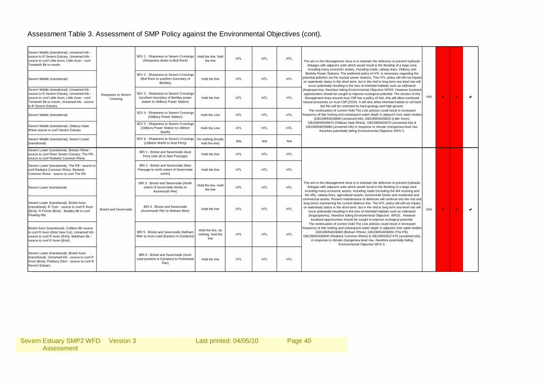
Severn Estuary SMP2 WFD Assessment
Version 3
Last printed: 04/05/10
Page 40
Assessment Table 3. Assessment of SMP Policy against the Environmental Objectives (cont). Severn Middle (transitional), Unnamed trib - source to R Severn Estuary, Unnamed trib - source to conf Little Avon, Little Avon - conf Tortworth Bk to mouth
Hold the line, hold the line HTL HTL HTL
Severn Middle (transitional) Hold the line HTL HTL HTL
Severn Middle (transitional), Unnamed trib - source to R Severn Estuary, Unnamed trib - source to conf Little Avon, Little Avon - conf Tortworth Bk to mouth, Unnamed trib - source to R Severn Estuary
Hold the line HTL HTL HTL
Severn Middle (transitional) Hold the Line HTL HTL HTL
Severn Middle (transitional), Oldbury Naite Rhine source to conf Severn Estuary Hold the Line HTL HTL HTL
Severn Middle (transitional), Severn Lower (transitional)
Do nothing (locally hold the line) NAI NAI NAI
Severn Lower (transitional), Bisham Rhine - source to conf RIver Severn Estuary, The Pill - source to conf Redwick Common Rhine
Hold the line HTL HTL HTL
Severn Lower (transitional), The Pill - source to conf Redwick Common Rhine, Redwick Common Rhine - source to conf The Pill
Hold the line HTL HTL HTL
Severn Lower (transitional) Hold the line, Hold the line HTL HTL HTL
Severn Lower (transitional), Bristol Avon (transitional), R Trym - source to conf R Avon (Brist), R Frome (Brist) - Bradley Bk to conf Floating Hbr
Hold the line HTL HTL HTL
Bristol Avon (transitional), Colliters Bk source to conf R Avon (Brist New Cut), Unnamed trib - source to conf R Avon (Brist), Markham Bk - source to conf R Avon (Brist),
Hold the line, do nothing, hold the
lineHTL HTL HTL
Severn Lower (transitional), Bristol Avon (transitional), Unnamed trib - source to conf R Avon (Brist), Portbury Ditch - source to conf R Severn Estuary
Hold the line HTL HTL HTL
The aim in this Management Area is to maintain the defences to prevent hydraulic linkages with adjacent units which would result in the flooding of a large area including many economic assets, including roads, railway lines, Oldbury and
Berkely Power Stations. The preferred policy of HTL is necessary regarding the potential pollution via the nuclear power stations. This HTL policy will will not impact on waterbody status in the short term, but in the mid to long term sea level rise will
occur potentially resulting in the loss of intertidal habitats such as saltmarsh (Angiosperms), therefore failing Environmental Objective WFD2. However localised opportunities should be sought to improve ecological potential. The section of this Management Area around Aust Cliff has a policy of NAI, this will allow continued
natural processes on Aust Cliff (SSSI). It will also allow intertidal habitat to roll back but this will be restricted by hard geology and high ground.
The continuation of current Hold The Line policies could result in increased frequency of tide locking and subsequent water depth in adjacent river water bodies
(GB109054026690 (unnamed trib), GB109054026620 (Little Avon), GB109054026670 (Oldbury Nate Rhine), GB10905402670 (unnamed trib) &
GB109054026680 (unnamed trib) in response to climate change/sea level rise, therefore potentially failing Environmental Objective WFD 3.
The aim in this Management Area is to maintain the defences to prevent hydraulic linkages with adjacent units which would result in the flooding of a large area
including many economic assets, including roads (including the M4 crossing and the M5), railway lines, agricultural assets, Avonmouth Docks and residential and
commercial assets. Present maintenance of defences will continue into the mid and long terms maintaining the current defence line. The HTL policy will will not impact on waterbody status in the short term, but in the mid to long term sea level rise will
occur potentially resulting in the loss of intertidal habitats such as saltmarsh (Angiosperms), therefore failing Environemntal Objective WFD2. However
localised opportunities should be sought to improve ecological potential.
Bristol and Severnside
BRI 6 - Bristol and Severnside (Avon road (eastern in Gordano) to Portishead
Pier)
BRI 5 - Bristol and Severnside (Netham Weir to Avon road (Eastern in Gordano))
BRI 1 - Bristol and Severnside (Aust Ferry (site of) to New Passage)
BRI 2 - Bristol and Severnside (New Passage to north extent of Severnside
works)
BRI 3 - Bristol and Severnside (North extent of Severnside Works to
Avonmouth Pier)
BRI 4 - Bristol and Severnside (Avonmouth Pier to Netham Weir)
SEV 6 - Sharpness to Severn Crossings (Littleton Warth to Aust Ferry)
SEV 1 - Sharpness to Severn Crossings (Sharpness docks to Bull Rock)
SEV 2 - Sharpness to Severn Crossings (Bull Rock to southern boundary of
Berkley)
SEV 3 - Sharpness to Severn Crossings (southern boundary of Berkley power
station to Oldbury Power Station)
SEV 5 - Sharpness to Severn Crossings (Oldbury Power Station to Littleton
Warth)
SEV 4 - Sharpness to Severn Crossings (Oldbury Power Station)
Sharpness to Severn Crossing
The continuation of current Hold The Line policies could result in increased frequency of tide locking and subsequent water depth in adjacent river water bodies
(GB109054026660 (Bisham Rhine), GB109054026650 (The Pill), GB109054026640 (Redwick Common Rhine) & GB109053027470 (unnamed trib),
in response to climate change/sea level rise, therefore potentially failing Environmental Objective WFD 3.
r aN/A r
N/A r r a
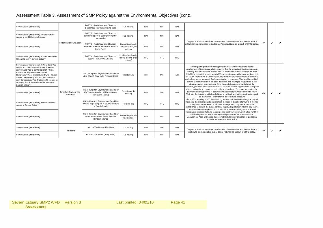
Severn Estuary SMP2 WFD Assessment
Version 3
Last printed: 04/05/10
Page 41
Assessment Table 3. Assessment of SMP Policy against the Environmental Objectives (cont). Severn Lower (transitional) Do nothing NAI NAI NAI
Severn Lower (transitional), Portbury Ditch - source to conf R Severn Estuary Do nothing NAI NAI NAI
Severn Lower (transitional)Do nothing (locally retreat the line), Do
nothingNAI NAI NAI
Severn Lower (transitional), R Land Yeo - conf R Kenn to conf R Severn Estuary
Hold the line (locally retreat the line or do
nothing)HTL HTL HTL
Severn Lower (transitional), R New Blind Yeo - source to conf R Severn Estuary, R Kenn - conf R Land Yeo to conf Blackditch Rhyne, Broadstone Rhyne - source to conf Congresbury Yeo, Broadstone Rhyne - source to conf Congresbury Yeo, R Yeo - source to conf Congresbury Yeo, Oldbridge R - source to nr Manor Fm, R Banwell - source to conf R Banwell Estuary
Hold the Line MR MR MR
Severn Lower (transitional) Do nothing, do nothing NAI NAI NAI
Severn Lower (transitional), Redcroft Rhyne - source to Severn Estuary Hold the line HTL HTL HTL
Severn Lower (transitional) Do nothing (locally hold the line) NAI NAI NAI
Severn Lower (transitional) Do nothing NAI NAI NAI
Severn Lower (transitional) Do nothing NAI NAI NAI
Portishead and Clevedon
Kingston Seymour and Sand Bay
The Holms
HOL 1 - The Holms (Flat Holm)
HOL 2 - The Holms (Sttep Holm)
KIN 4 - Kingston Seymour and Sand Bay (southern extent of Beach Road to
Birnbeck Island)
PORT 3 - Portishead and Clevedon (southern extent of Esplanade Road to
Ladye Point)
PORT 4 - Portishead and Clevedon (Ladye Point to Old Church)
KIN 1 - Kingston Seymour and Sand Bay (Old Church Road to St Thomas Head)
KIN 2 - Kingston Seymour and Sand Bay (St Thomas Head to Middle Hope car
park (Sand Point))
KIN 3 - Kingston Seymour and Sand Bay (Middle Hope car park to southern extent
of Beach Road)
PORT 1 - Portishead and Clevedon (Portishead Pier to swimming pool)
PORT 2 - Portishead and Clevedon (swimming pool to Southern extent of
esplanade)The plan is to allow the natural development of the coastline and, hence, there is
unlikely to be deterioration in Ecological Potential/Status as a result of SMP2 policy.
The plan is to allow the natural development of the coastline and, hence, there is unlikely to be deterioration in Ecological Potential as a result of SMP2 policy.
The long term plan in this Management Area is to encourage the natural development of the estuary, whilst ensuring that the impacts of flooding to people, property and infrastructure are reduced. At the north eastern section of the area
(KIN1) the policy in the short term is MR, where defences will remain in place, but will not be maintained. In the mid term, the defences are expected to fail and in the mid to long term a Managed Realignment policy is proposed. This would most likely
involve the construction of set back defences. The managed realignment of the defences would help to reduce flood risk and allow natural evolution of the
shoreline, provide opportunities for habitat creation, provide opportunities to expand exiting wetlands, or replace areas lost by sea level rise. Therefore supporting the Environmnetal Objectives. A policy of NAI around the exposure of MIddle Hope
SSSI into the long term will allow habitats to roll back so that intertidal features will be maintained and there will be continued exposure
of the SSSI. A policy of HTL into the long term around Kewstoke along the bay will mean that the existing sand dunes remain in [place in the short term, but in the mid
to long term are expected to fail, so a management programme should be established to ensure the dunes continue to provide protection into the long term.
Coastla squeeze is expected to occur in the in the mid to long term, which will impact upon intertidal habitats (Angiosperms, benthic/macroinvertebrates, fish) but
this is mitigated for by the managed realignment set out elswhere in the Management Area and hence, there is not likely to be deterioration in Ecological
Potential as a result of SMP policy.
aN/A a
a
N/A a a
N/A a
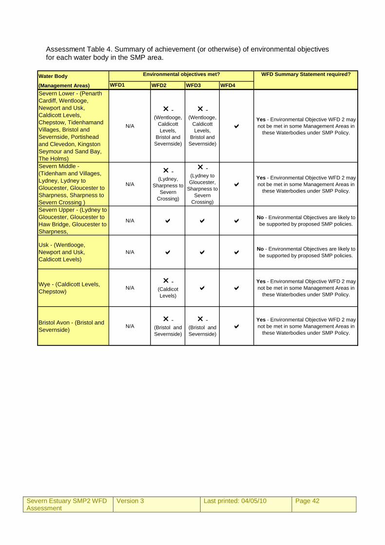
Severn Estuary SMP2 WFD Assessment
Version 3
Last printed: 04/05/10 Page 42
Assessment Table 4. Summary of achievement (or otherwise) of environmental objectives for each water body in the SMP area.
Water Body
(Management Areas) WFD1 WFD2 WFD3 WFD4Severn Lower - (Penarth Cardiff, Wentlooge, Newport and Usk, Caldicott Levels, Chepstow, Tidenhamand Villages, Bristol and Severnside, Portishead and Clevedon, Kingston Seymour and Sand Bay, The Holms)
N/A
r - (Wentlooge,
Caldicott Levels,
Bristol and Severnside)
r - (Wentlooge,
Caldicott Levels,
Bristol and Severnside)
aYes - Environmental Objective WFD 2 may not be met in some Management Areas in
these Waterbodies under SMP Policy.
Severn Middle - (Tidenham and Villages, Lydney, Lydney to Gloucester, Gloucester to Sharpness, Sharpness to Severn Crossing )
N/A
r - (Lydney,
Sharpness to Severn
Crossing)
r - (Lydney to Gloucester,
Sharpness to Severn
Crossing)
aYes - Environmental Objective WFD 2 may not be met in some Management Areas in
these Waterbodies under SMP Policy.
Severn Upper - (Lydney to Gloucester, Gloucester to Haw Bridge, Gloucester to Sharpness,
N/A a a aNo - Environmental Objectives are likely to be supported by proposed SMP policies.
Usk - (Wentlooge, Newport and Usk, Caldicott Levels)
N/A a a aNo - Environmental Objectives are likely to be supported by proposed SMP policies.
Wye - (Caldicott Levels, Chepstow) N/A
r - (Caldicot Levels)
a aYes - Environmental Objective WFD 2 may not be met in some Management Areas in
these Waterbodies under SMP Policy.
Bristol Avon - (Bristol and Severnside) N/A
r - (Bristol and Severnside)
r - (Bristol and Severnside)
aYes - Environmental Objective WFD 2 may not be met in some Management Areas in
these Waterbodies under SMP Policy.
WFD Summary Statement required?Environmental objectives met?
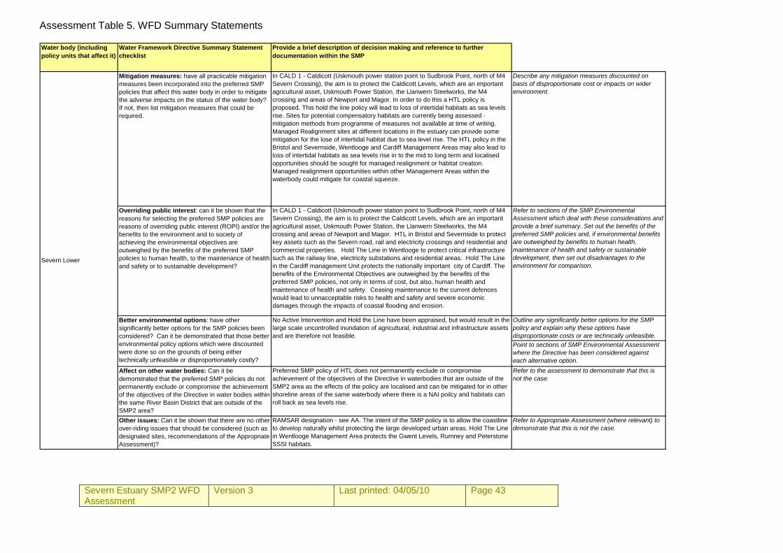
Severn Estuary SMP2 WFD Assessment
Version 3
Last printed: 04/05/10 Page 43
Assessment Table 5. WFD Summary Statements Water body (including policy units that affect it)
Water Framework Directive Summary Statement checklist
Provide a brief description of decision making and reference to further documentation within the SMP
Mitigation measures: have all practicable mitigation measures been incorporated into the preferred SMP policies that affect this water body in order to mitigate the adverse impacts on the status of the water body? If not, then list mitigation measures that could be required.
In CALD 1 - Caldicott (Uskmouth power station point to Sudbrook Point, north of M4 Severn Crossing), the aim is to protect the Caldicott Levels, which are an important agricultural asset, Uskmouth Power Station, the Llanwern Steelworks, the M4 crossing and areas of Newport and Magor. In order to do this a HTL policy is proposed. This hold the line policy will lead to loss of intertidal habitats as sea levels rise. Sites for potential compensatory habitats are currently being assessed - mitigation methods from programme of measures not available at time of writing. Managed Realignment sites at different locations in the estuary can provide some mitigation for the lose of intertidal habitat due to sea level rise. The HTL policy in the Bristol and Severnside, Wentlooge and Cardiff Management Areas may also lead to loss of intertidal habitats as sea levels rise in to the mid to long term and localised opportunities should be sought for managed realignment or habitat creation. Managed realignment opportunities within other Management Areas within the waterbody could mitigate for coastal squeeze.
Describe any mitigation measures discounted on basis of disproportionate cost or impacts on wider environment.
Overriding public interest: can it be shown that the reasons for selecting the preferred SMP policies are reasons of overriding public interest (ROPI) and/or the benefits to the environment and to society of achieving the environmental objectives are outweighed by the benefits of the preferred SMP policies to human health, to the maintenance of health and safety or to sustainable development?
In CALD 1 - Caldicott (Uskmouth power station point to Sudbrook Point, north of M4 Severn Crossing), the aim is to protect the Caldicott Levels, which are an important agricultural asset, Uskmouth Power Station, the Llanwern Steelworks, the M4 crossing and areas of Newport and Magor. HTL in Bristol and Severnside to protect key assets such as the Severn road, rail and electricity crossings and residential and commercial properties. Hold The Line in Wentlooge to protect critical infrastructure such as the railway line, electricity substations and residential areas. Hold The Line in the Cardiff management Unit protects the nationally important city of Cardiff. The benefits of the Environmental Objectives are outweighed by the benefits of the preferred SMP policies, not only in terms of cost, but also, human health and maintenance of health and safety. Ceasing maintenance to the current defences would lead to unnacceptable risks to health and safety and severe economic damages through the impacts of coastal flooding and erosion.
Refer to sections of the SMP Environmental Assessment which deal with these considerations and provide a brief summary. Set out the benefits of the preferred SMP policies and, if environmental benefits are outweighed by benefits to human health, maintenance of health and safety or sustainable development, then set out disadvantages to the environment for comparison.
Outline any significantly better options for the SMP policy and explain why these options have disproportionate costs or are technically unfeasible.Point to sections of SMP Environmental Assessment where the Directive has been considered against each alternative option.
Affect on other water bodies: Can it be demonstrated that the preferred SMP policies do not permanently exclude or compromise the achievement of the objectives of the Directive in water bodies within the same River Basin District that are outside of the SMP2 area?
Preferred SMP policy of HTL does not permanently exclude or compromise achievement of the objectives of the Directive in waterbodies that are outside of the SMP2 area as the effects of the policy are localised and can be mitigated for in other shoreline areas of the same waterbody where there is a NAI poilcy and habitats can roll back as sea levels rise.
Refer to the assessment to demonstrate that this is not the case.
Other issues: Can it be shown that there are no other over-riding issues that should be considered (such as designated sites, recommendations of the Appropriate Assessment)?
RAMSAR designation - see AA. The intent of the SMP policy is to allow the coastline to develop naturally whilst protecting the large developed urban areas. Hold The Line in Wentlooge Management Area protects the Gwent Levels, Rumney and Peterstone SSSI habitats.
Refer to Appropriate Assessment (where relevant) to demonstrate that this is not the case.
No Active Intervention and Hold the Line have been appraised, but would result in the large scale uncontrolled inundation of agricultural, industrial and infrastructure assets and are therefore not feasible.
Severn Lower
Better environmental options: have other significantly better options for the SMP policies been considered? Can it be demonstrated that those better environmental policy options which were discounted were done so on the grounds of being either technically unfeasible or disproportionately costly?
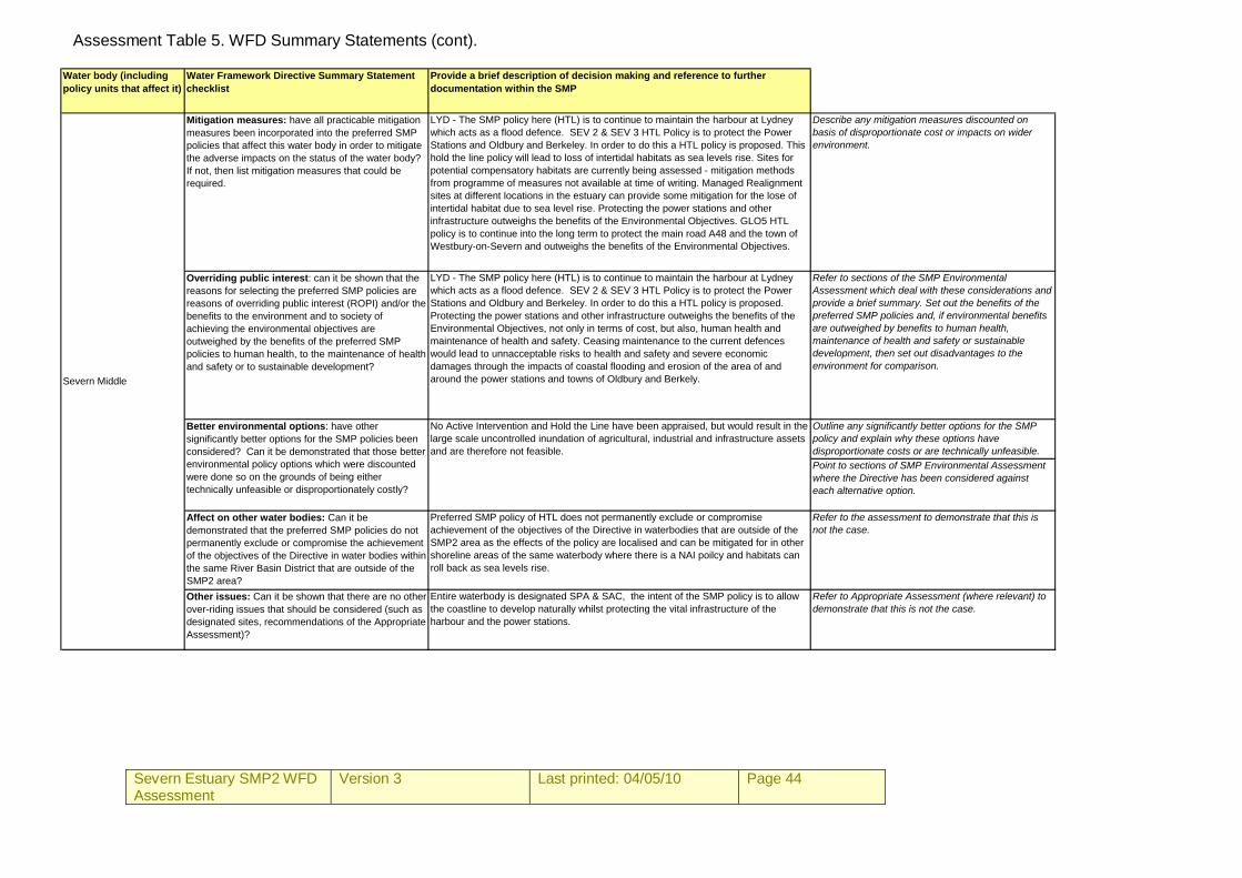
Severn Estuary SMP2 WFD Assessment
Version 3
Last printed: 04/05/10 Page 44
Assessment Table 5. WFD Summary Statements (cont).
Water body (including policy units that affect it)
Water Framework Directive Summary Statement checklist
Provide a brief description of decision making and reference to further documentation within the SMP
Mitigation measures: have all practicable mitigation measures been incorporated into the preferred SMP policies that affect this water body in order to mitigate the adverse impacts on the status of the water body? If not, then list mitigation measures that could be required.
LYD - The SMP policy here (HTL) is to continue to maintain the harbour at Lydney which acts as a flood defence. SEV 2 & SEV 3 HTL Policy is to protect the Power Stations and Oldbury and Berkeley. In order to do this a HTL policy is proposed. This hold the line policy will lead to loss of intertidal habitats as sea levels rise. Sites for potential compensatory habitats are currently being assessed - mitigation methods from programme of measures not available at time of writing. Managed Realignment sites at different locations in the estuary can provide some mitigation for the lose of intertidal habitat due to sea level rise. Protecting the power stations and other infrastructure outweighs the benefits of the Environmental Objectives. GLO5 HTL policy is to continue into the long term to protect the main road A48 and the town of Westbury-on-Severn and outweighs the benefits of the Environmental Objectives.
Describe any mitigation measures discounted on basis of disproportionate cost or impacts on wider environment.
Overriding public interest: can it be shown that the reasons for selecting the preferred SMP policies are reasons of overriding public interest (ROPI) and/or the benefits to the environment and to society of achieving the environmental objectives are outweighed by the benefits of the preferred SMP policies to human health, to the maintenance of health and safety or to sustainable development?
LYD - The SMP policy here (HTL) is to continue to maintain the harbour at Lydney which acts as a flood defence. SEV 2 & SEV 3 HTL Policy is to protect the Power Stations and Oldbury and Berkeley. In order to do this a HTL policy is proposed. Protecting the power stations and other infrastructure outweighs the benefits of the Environmental Objectives, not only in terms of cost, but also, human health and maintenance of health and safety. Ceasing maintenance to the current defences would lead to unnacceptable risks to health and safety and severe economic damages through the impacts of coastal flooding and erosion of the area of and around the power stations and towns of Oldbury and Berkely.
Refer to sections of the SMP Environmental Assessment which deal with these considerations and provide a brief summary. Set out the benefits of the preferred SMP policies and, if environmental benefits are outweighed by benefits to human health, maintenance of health and safety or sustainable development, then set out disadvantages to the environment for comparison.
Outline any significantly better options for the SMP policy and explain why these options have disproportionate costs or are technically unfeasible.Point to sections of SMP Environmental Assessment where the Directive has been considered against each alternative option.
Affect on other water bodies: Can it be demonstrated that the preferred SMP policies do not permanently exclude or compromise the achievement of the objectives of the Directive in water bodies within the same River Basin District that are outside of the SMP2 area?
Preferred SMP policy of HTL does not permanently exclude or compromise achievement of the objectives of the Directive in waterbodies that are outside of the SMP2 area as the effects of the policy are localised and can be mitigated for in other shoreline areas of the same waterbody where there is a NAI poilcy and habitats can roll back as sea levels rise.
Refer to the assessment to demonstrate that this is not the case.
Other issues: Can it be shown that there are no other over-riding issues that should be considered (such as designated sites, recommendations of the Appropriate Assessment)?
Entire waterbody is designated SPA & SAC, the intent of the SMP policy is to allow the coastline to develop naturally whilst protecting the vital infrastructure of the harbour and the power stations.
Refer to Appropriate Assessment (where relevant) to demonstrate that this is not the case.
No Active Intervention and Hold the Line have been appraised, but would result in the large scale uncontrolled inundation of agricultural, industrial and infrastructure assets and are therefore not feasible.
Severn Middle
Better environmental options: have other significantly better options for the SMP policies been considered? Can it be demonstrated that those better environmental policy options which were discounted were done so on the grounds of being either technically unfeasible or disproportionately costly?
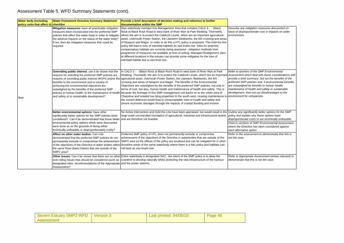
Severn Estuary SMP2 WFD Assessment
Version 3
Last printed: 04/05/10 Page 45
Assessment Table 5. WFD Summary Statements (cont). Water body (including policy units that affect it)
Water Framework Directive Summary Statement checklist
Provide a brief description of decision making and reference to further documentation within the SMP
Mitigation measures: have all practicable mitigation measures been incorporated into the preferred SMP policies that affect this water body in order to mitigate the adverse impacts on the status of the water body? If not, then list mitigation measures that could be required.
Wye waterbody overlaps into Management Area that contains CALD 3 - - (Black Rock at Black Rock Road to west bank of River Wye at Park Redding, Thornwell), where the aim is to protect the Caldicott Levels, which are an important agricultural asset, Uskmouth Power Station, the Llanwern Steelworks, the M4 crossing and areas of Newport and Magor. In order to do this a HTL policy is proposed. This hold the line policy will lead to loss of intertidal habitats as sea levels rise. Sites for potential compensatory habitats are currently being assessed - mitigation methods from programme of measures not available at time of writing. Managed Realignment sites at different locations in the estuary can provide some mitigation for the lose of intertidal habitat due to sea level rise.
Describe any mitigation measures discounted on basis of disproportionate cost or impacts on wider environment.
Overriding public interest: can it be shown that the reasons for selecting the preferred SMP policies are reasons of overriding public interest (ROPI) and/or the benefits to the environment and to society of achieving the environmental objectives are outweighed by the benefits of the preferred SMP policies to human health, to the maintenance of health and safety or to sustainable development?
In CALD 3 - - (Black Rock at Black Rock Road to west bank of River Wye at Park Redding, Thornwell), the aim is to protect the Caldicott Levels, which are an important agricultural asset, Uskmouth Power Station, the Llanwern Steelworks, the M4 crossing and areas of Newport and Magor. The benefits of the Environmental Objectives are outweighed by the benefits of the preferred SMP policies, not only in terms of cost, but also, human health and maintenance of health and safety. This is because the frontage of this SMP management unit backs on to the urban area of Chepstow and isolated low lying properties to the south west. ceasing maintenance to the current defences would lead to unnacceptable risks to health and safety and severe economic damages through the impacts of coastal flooding and erosion.
Refer to sections of the SMP Environmental Assessment which deal with these considerations and provide a brief summary. Set out the benefits of the preferred SMP policies and, if environmental benefits are outweighed by benefits to human health, maintenance of health and safety or sustainable development, then set out disadvantages to the environment for comparison.
Outline any significantly better options for the SMP policy and explain why these options have disproportionate costs or are technically unfeasible.Point to sections of SMP Environmental Assessment where the Directive has been considered against each alternative option.
Affect on other water bodies: Can it be demonstrated that the preferred SMP policies do not permanently exclude or compromise the achievement of the objectives of the Directive in water bodies within the same River Basin District that are outside of the SMP2 area?
Preferred SMP policy of HTL does not permanently exclude or compromise achievement of the objectives of the Directive in waterbodies that are outside of the SMP2 area as the effects of the policy are localised and can be mitigated for in other shoreline areas of the same waterbody where there is a NAI poilcy and habitats can roll back as sea levels rise.
Refer to the assessment to demonstrate that this is not the case.
Other issues: Can it be shown that there are no other over-riding issues that should be considered (such as designated sites, recommendations of the Appropriate Assessment)?
Entire waterbody is designated SAC, the intent of the SMP policy is to allow the coastline to develop naturally whilst protecting the vital infrastructure of the harbour and the power stations.
Refer to Appropriate Assessment (where relevant) to demonstrate that this is not the case.
No Active Intervention and Hold the Line have been appraised, but would result in the large scale uncontrolled inundation of agricultural, industrial and infrastructure assets and are therefore not feasible.
Better environmental options: have other significantly better options for the SMP policies been considered? Can it be demonstrated that those better environmental policy options which were discounted were done so on the grounds of being either technically unfeasible or disproportionately costly?
Wye
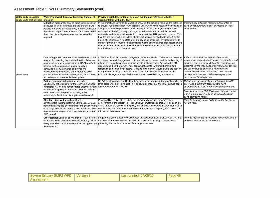
Severn Estuary SMP2 WFD Assessment
Version 3
Last printed: 04/05/10 Page 46
Assessment Table 5. WFD Summary Statements (cont).
Water body (including policy units that affect it)
Water Framework Directive Summary Statement checklist
Provide a brief description of decision making and reference to further documentation within the SMP
Mitigation measures: have all practicable mitigation measures been incorporated into the preferred SMP policies that affect this water body in order to mitigate the adverse impacts on the status of the water body? If not, then list mitigation measures that could be required.
In the Bristol and Severnside Management Area, the aim is to maintain the defences to prevent hydraulic linkages with adjacent units which would result in the flooding of a large area including many economic assets, including roads (including the M4 crossing and the M5), railway lines, agricultural assets, Avonmouth Docks and residential and commercial assets. In order to do this a HTL policy is proposed. This hold the line policy will lead to loss of intertidal habitats as sea levels rise. Sites for potential compensatory habitats are currently being assessed - mitigation methods from programme of measures not available at time of writing. Managed Realignment sites at different locations in the estuary can provide some mitigation for the lose of intertidal habitat due to sea level rise.
Describe any mitigation measures discounted on basis of disproportionate cost or impacts on wider environment.
Overriding public interest: can it be shown that the reasons for selecting the preferred SMP policies are reasons of overriding public interest (ROPI) and/or the benefits to the environment and to society of achieving the environmental objectives are outweighed by the benefits of the preferred SMP policies to human health, to the maintenance of health and safety or to sustainable development?
In the Bristol and Severnside Management Area, the aim is to maintain the defences to prevent hydraulic linkages with adjacent units which would result in the flooding of a large area including many economic assets, including roads (including the M4 crossing and the M5), railway lines, agricultural assets, Avonmouth Docks and residential and commercial assets. Ceasing maintenance would lead to the flooding of large areas, leading to unnacceptable risks to health and safety and severe economic damages through the impacts of that coastal flooding and erosion.
Refer to sections of the SMP Environmental Assessment which deal with these considerations and provide a brief summary. Set out the benefits of the preferred SMP policies and, if environmental benefits are outweighed by benefits to human health, maintenance of health and safety or sustainable development, then set out disadvantages to the environment for comparison.
Outline any significantly better options for the SMP policy and explain why these options have disproportionate costs or are technically unfeasible.
Point to sections of SMP Environmental Assessment where the Directive has been considered against each alternative option.
Affect on other water bodies: Can it be demonstrated that the preferred SMP policies do not permanently exclude or compromise the achievement of the objectives of the Directive in water bodies within the same River Basin District that are outside of the SMP2 area?
Preferred SMP policy of HTL does not permanently exclude or compromise achievement of the objectives of the Directive in waterbodies that are outside of the SMP2 area as the effects of the policy are localised and can be mitigated for in other shoreline areas of the same waterbody where there is a NAI poilcy and habitats can roll back as sea levels rise.
Refer to the assessment to demonstrate that this is not the case.
Other issues: Can it be shown that there are no other over-riding issues that should be considered (such as designated sites, recommendations of the Appropriate Assessment)?
Large areas of the Bristol Avonwaterbody are designated as either SPA or SAC and the intent of the SMP Policy is to allow the coastline to develop naturally whilst protecting the vital infrastructure of the large urban area.
Refer to Appropriate Assessment (where relevant) to demonstrate that this is not the case.
Better environmental options: have other significantly better options for the SMP policies been considered? Can it be demonstrated that those better environmental policy options which were discounted were done so on the grounds of being either technically unfeasible or disproportionately costly?
Bristol Avon
No Active Intervention and Hold the Line have been appraised, but would result in the large scale uncontrolled inundation of agricultural, industrial and infrastructure assets and are therefore not feasible.
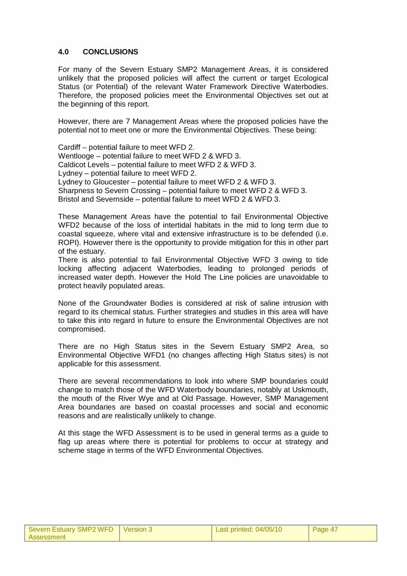
Severn Estuary SMP2 WFD Assessment
Version 3
Last printed: 04/05/10 Page 47
4.0 CONCLUSIONS For many of the Severn Estuary SMP2 Management Areas, it is considered unlikely that the proposed policies will affect the current or target Ecological Status (or Potential) of the relevant Water Framework Directive Waterbodies. Therefore, the proposed policies meet the Environmental Objectives set out at the beginning of this report. However, there are 7 Management Areas where the proposed policies have the potential not to meet one or more the Environmental Objectives. These being: Cardiff – potential failure to meet WFD 2. Wentlooge – potential failure to meet WFD 2 & WFD 3. Caldicot Levels – potential failure to meet WFD 2 & WFD 3. Lydney – potential failure to meet WFD 2. Lydney to Gloucester – potential failure to meet WFD 2 & WFD 3. Sharpness to Severn Crossing – potential failure to meet WFD 2 & WFD 3. Bristol and Severnside – potential failure to meet WFD 2 & WFD 3. These Management Areas have the potential to fail Environmental Objective WFD2 because of the loss of intertidal habitats in the mid to long term due to coastal squeeze, where vital and extensive infrastructure is to be defended (i.e. ROPI). However there is the opportunity to provide mitigation for this in other part of the estuary. There is also potential to fail Environmental Objective WFD 3 owing to tide locking affecting adjacent Waterbodies, leading to prolonged periods of increased water depth. However the Hold The Line policies are unavoidable to protect heavily populated areas. None of the Groundwater Bodies is considered at risk of saline intrusion with regard to its chemical status. Further strategies and studies in this area will have to take this into regard in future to ensure the Environmental Objectives are not compromised. There are no High Status sites in the Severn Estuary SMP2 Area, so Environmental Objective WFD1 (no changes affecting High Status sites) is not applicable for this assessment. There are several recommendations to look into where SMP boundaries could change to match those of the WFD Waterbody boundaries, notably at Uskmouth, the mouth of the River Wye and at Old Passage. However, SMP Management Area boundaries are based on coastal processes and social and economic reasons and are realistically unlikely to change. At this stage the WFD Assessment is to be used in general terms as a guide to flag up areas where there is potential for problems to occur at strategy and scheme stage in terms of the WFD Environmental Objectives.
Severn Estuary SMP2 WFD Assessment
Version 3
Last printed: 04/05/10 Page 48
REFERENCES Defra (2006). Shoreline management plan guidance Volume 2: Procedures. Department for Environment, Food and Rural Affairs, March 2006. Environment Agency (2009). Operational Instruction 82_09. Water Framework Directive: Step by Step Process for Assessing Shoreline Management Plans. 24/03/09. Royal Haskoning (2008). Water Framework Directive: Retrospective Assessment for the River Tyne to Flamborough Head SMP2. December 2008. Royal Haskoning (2009). Appendix K: Water Framework Directive Assessment Northumberland SMP2. May 2009. Royal Haskoning (2009). Poole and Christchurch Bays SMP2 (Draft). August 2009.


![[MS-WFDAA]: Wi-Fi Direct (WFD) Application to Application ...... · Wi-Fi Direct (WFD) Application to Application Protocol ... For questions and support, ... (WFD) Application to](https://img.pdfslide.net/doc/110x75/5b5156027f8b9ac4368c0843/ms-wfdaa-wi-fi-direct-wfd-application-to-application-wi-fi-direct.jpg)