Embed Size (px)
Citation preview

SECTION 5RETICULAR CANAL SYSTEM FOR INTERLINKING INDIAN RIVERS
By, Dr. Shivu. P.No. 757, Vinayamarga, 11th cross, Siddarthanagar, Mysore 11. PIN: 570011.Cell: 9448477380, Land phone:0821 2561277, 0821 4000778Mail: [email protected] 1

Reticular canal system
4
Eradication of drought will also eliminates the poverty to the maximum extent especially in our nation where the maximum people depend on rain for their livelihood i.e. for Agriculture.
Drought leading to Poverty acting as the obstacle in the process of national progress is the topic of discussion and it is the national emergency that we need to address.
And the answer to this national emergency is present in ‘RCS for Interlinking Indian rivers’ that I need to propagate, for which I seek the help of all of you.

3. What are the uses?6
RETICULAR CANAL SYSTEM FOR INTERLINKING INDIAN RIVERS –
My talk under the present heading will be centered on,
1. Why We need to interlink?
2. How We can interlink?
People waiting
for the rain to
come and
becoming old.
Source [16]
Topic series: 195. Topic: 1. F&F – Poor rain fall.
People need notlook at the sky forrain with theestablishment ofRCS.
9
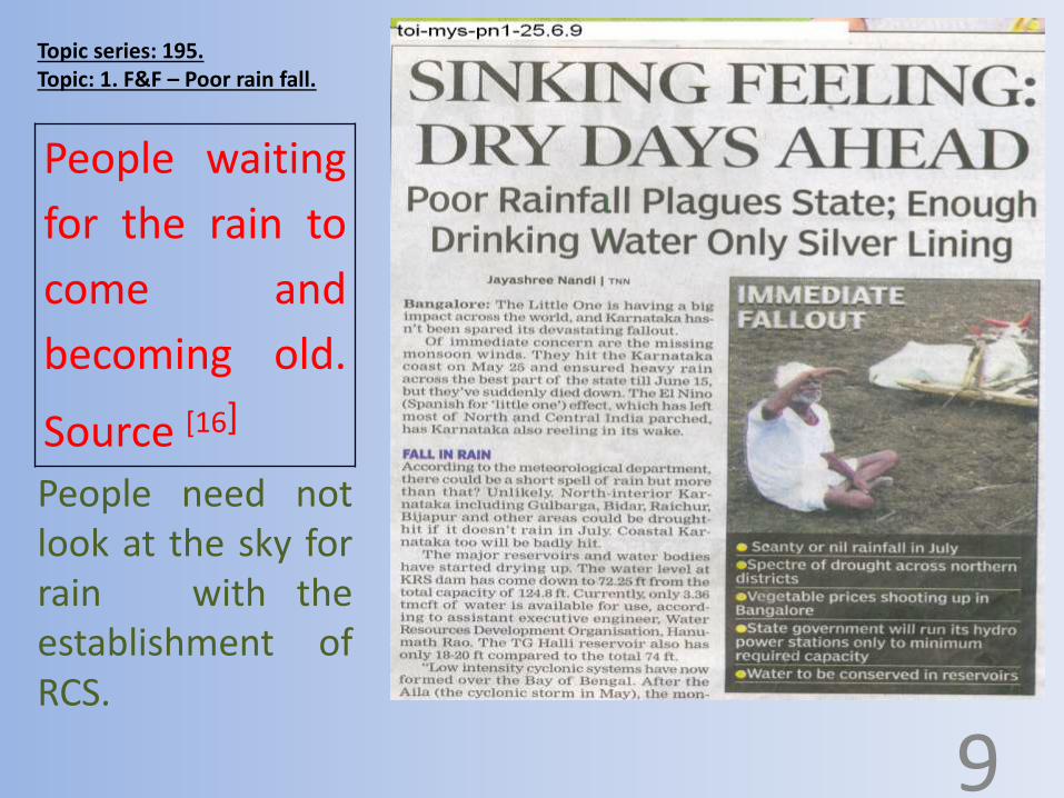
Topic series: 196 Topic: 2. F&F – Water levels in reservoirs in different seasons.
Source: Newspaper.
Scenario 1:Reservoirs arefull some times.
10

Topic series: 196 Topic: 2. F&F – Water levels in reservoirs in different seasons.
Source [17]
Scenario 2:Reservoirs aresome what filledbut not to theextent ofreleasing thewater.
11

Topic series: 196 Topic: 2. F&F – Water levels in reservoirs in different seasons.
Source [18]
Scenario 3:Reservoirs areempty formany monthsin a year.
12

Topic series: 196 Topic: 2. F&F – Water levels in reservoirs in different seasons.
On the other hand many reservoirs will remain empty waiting forlong time for the rain to occur in its catchment area or for therelease of water stored at another reservoir even if the water whichis present in the reservoir is insufficient to provide irrigation to thelands depending on that reservoir.
13
Lessons from the previous scenarios:All the water which generates in one river basin cannot be storedwith any number of reservoirs, thus we need to leave the water tothe sea which exceed the capacity of the reservoir/s and thepeople will not have any benefit out of the water which reachesthe sea.

Topic series: 196 Topic: 2. F&F – Water levels in reservoirs in different seasons.
Whatever number of reservoir system we have today with theirmaximum capacity is not sufficient for present population, that’s waydisputes are present and the tribunals to keep these ‘disputes fordecades’ exists.
13
Lessons from the previous scenarios:
Water will not come and fill the reservoir in a fraction of seconds; rain isnot going to happen like a flash. The raining is the process it takes itsown time, and thus the flow of water in its path.

Topic series: 196 Topic: 2. F&F – Water levels in reservoirs in different seasons.
Solution:RCS will supply water to all the possible placesfrom the higher level, before the water reachesthe lower level by assessing the water generationand the flow, not only in the reservoirs of the sameriver basin, but also ‘from’ and ‘to’ all the riverbasin. Do the same thing when there is good rainin the other river basin. 13
Topic series: 196 Topic: 2. F&F – Water levels in reservoirs in different seasons.
RCS distributes water to all the rivers, lakes,ponds, reservoirs and to all the places where everwe want, when there is rain at any place which ishigher to the place of storage.
14

Source: News paper.
Topic series: 197 Topic: 3. F&F – Not enough drinking water.
RCS will give solution for all these; the surface water we can use as per our demand, the underground water level will increase everywhere.
15
The recent development is, most of the bore wells are empty because we started using the bore wells more than its replenishment.
We are forced to use the bore well water even if its chemical quality is not good.

Source: News paper.
Source [20] Source [20]
Topic series: 198 Topic: 4. F&F – Fluorosis due to bore well water.
Surface water is the safe water withrespect to the chemicalcomposition of water is concernedunless it is not contaminated(Polluted) by the human activity.
16
Fluorosis: Nothing of this sort will happen with RCS, because all the people will get river (Surface) water for drinking purpose. We need not use the bore wells for any purpose.

Source: News paper.
Topic series: 199 Topic: 5. F&F – No water for irrigation.
Farmers need not struggle like this todo agriculture with RCS.
17
Source [22]
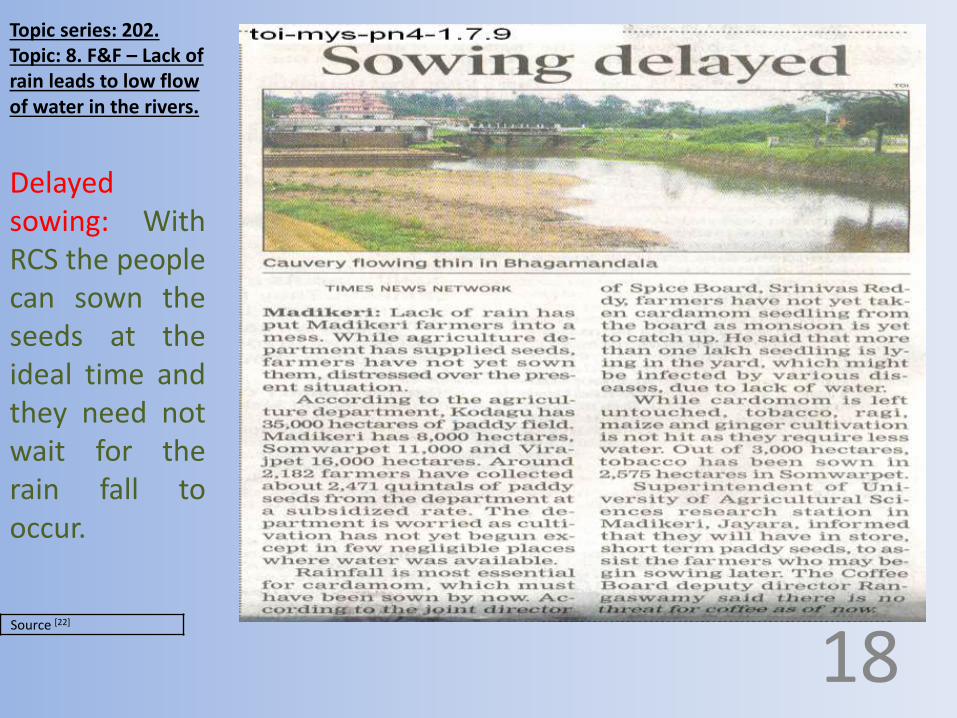
Topic series: 202. Topic: 8. F&F – Lack of rain leads to low flow of water in the rivers.
Delayedsowing: WithRCS the peoplecan sown theseeds at theideal time andthey need notwait for therain fall tooccur.
18

Source: News paper.
Topic series: 200.Topic: 6. F&F – Over crowded people to collect the water from a tanker.
Struggling to get the water for domestic use: Situations like thiswill not occur due to ‘scarcity of water’ (excluding the problemsassociated with the water supply system) with the establishmentof RCS.
19

Source [21]
Topic series: 201 Topic: 7. F&F – Protest for drinking water.
‘Population over growth in asmaller area of land awayfrom the source of water’ or‘When the demand is morethan the supply done by thenature’ is the cause for allsuch types of problems.
20
With the establishment ofRCS there will not be anyscarcity of water for anyreasons. With RCS peopleneed not protest like this forwater for domestic purposes.

Source [25]
Topic series: 205. Topic: 11. F&F – Scarcity of electricity.
With RCS adequate amount ofpower can be generated and can besupplied to all the parts of thenation through nationwide grids.These electricity generationstations are created along thecourse of RCS, at all the possibleplaces where we get optimumheight of fall of water from PC to SCin thousands of numbers withbetter capacity to produce theelectricity. 2
1
Scarcity of electricity:
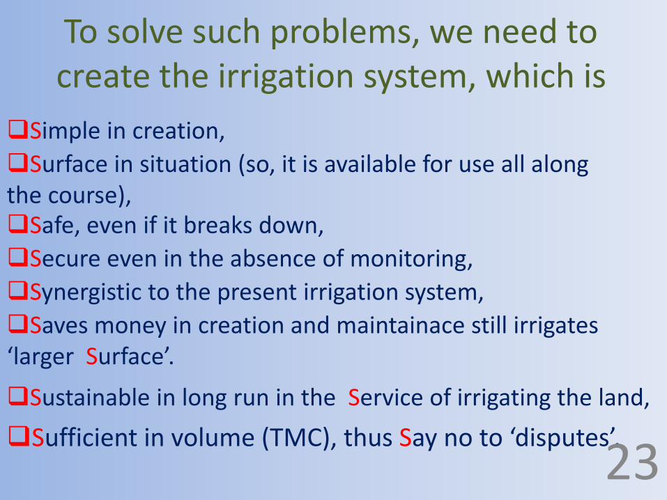
To solve such problems, we need to create the irrigation system, which is
Sufficient in volume (TMC), thus Say no to ‘disputes’. 23
Simple in creation,
Surface in situation (so, it is available for use all along the course), Safe, even if it breaks down,
Secure even in the absence of monitoring,
Synergistic to the present irrigation system,
Saves money in creation and maintainace still irrigates ‘larger Surface’.
Sustainable in long run in the Service of irrigating the land,

giving justice to
both. 24
RCS will act like a
‘bridge’
in a ‘reticular fashion’
between flood and drought prone area

Decreased nutritional intake and Poverty25
People looking at the sky for rain and
becoming old.
Dams remaining dry for most of
the time.
Finally people try farming with the
water in the bucket.
These leads to decrease in agricultural production ↓
Decreased personnel and family economy ↓

↓ Decreased nutritional intake and Poverty. 26
Insufficient water, poor quality of water in terms of chemical / microbiological parameters
↓ Increased incidence of diseases / work absenteeism / hospitalization
↓ Decreased productivity and increase in the expenditure

Effects of Poverty on:
Nation
27
PoorRich

Effects of poverty on:Poor:
28
Decreased intake of nutrition.
Smaller average built.
Decreased working capacity.
Decreased quality of life.
Act like the reservoir of diseases.Increased burden on cheaper hospitals (Government and charitable)Becoming less competitive in the present competitive world and remaining as poor in the next generation also.Expects favors from the government or unable to lead the life in the absence of support from the government.
If the nation has more number of poor, then that nation becomes poor .

Effects of poverty on:
29
Rich Less customers' for the products generated by the rich.
Quarrels with the rich while paying the bill.
Makes the rich to generate poor quality items to fulfill the requirement of the poor.
Rich cannot expect more from the poor in many types of services (e.g. Health service).
The rich need to confine himself in the place where only rich lives.

Effects of poverty on:
So, there is a relation between the irrigation and the overall national development.
30
NationLess generation of the money through the taxation.
Poor public infrastructure.Poor salary and benefits for the employs. Increased tendency to indulge in corruption ‘to fulfill the gap’ by the employs. Increase in the incidence of crime.

Sources:[16] Times of India News paper, Page number 1, dated 25.06.09.[17] Times of India News paper, Page number4, dated 28.06.09.[18] Times of India News paper, Page number6, dated 1.07.09.[19] Times of India News paper, Page number2, dated 26.6.2009.[20] Times of India News paper, Page number 4, dated 30.6.09.[21] Times of India News paper, Page number5, dated 15.5.09.[22] Times of India News paper, Page number4, dated 1.7.09.[23] Times of India News paper, Page number6, dated 28.05.09.[24] www.3dsyndication.com. DNA-Bangalore 20.7.9, Page number 12.[25] Times of India News paper, Page number4, dated 30.6.09.[26] Times of India News paper, dated 30.06.09.[27] Times of India News paper, Page number4, dated 1.07.09.[28] Economy of India. From Wikipedia, the free encyclopedia. This page was last modified
on 22 February 2009, at 23:16.
[29] Copyright © 2000 Indian Express Newspapers (Bombay) Ltd. Growth in per capita
income raises India's rank.mht.
[30] The Hindu Opinion - News Analysis MDG and India’s drinking water racing ahead at whatcost.mht.[31] Internet: India statistics facts and figures neoncarrot travelog.[32] Google earth.
31

Section 5:Reticular canal system for interlinking Indian rivers;
Chapter 6: Facts and figures related to Reservoirs of India:
Let us know few things about the reservoirs of INDIA.
32

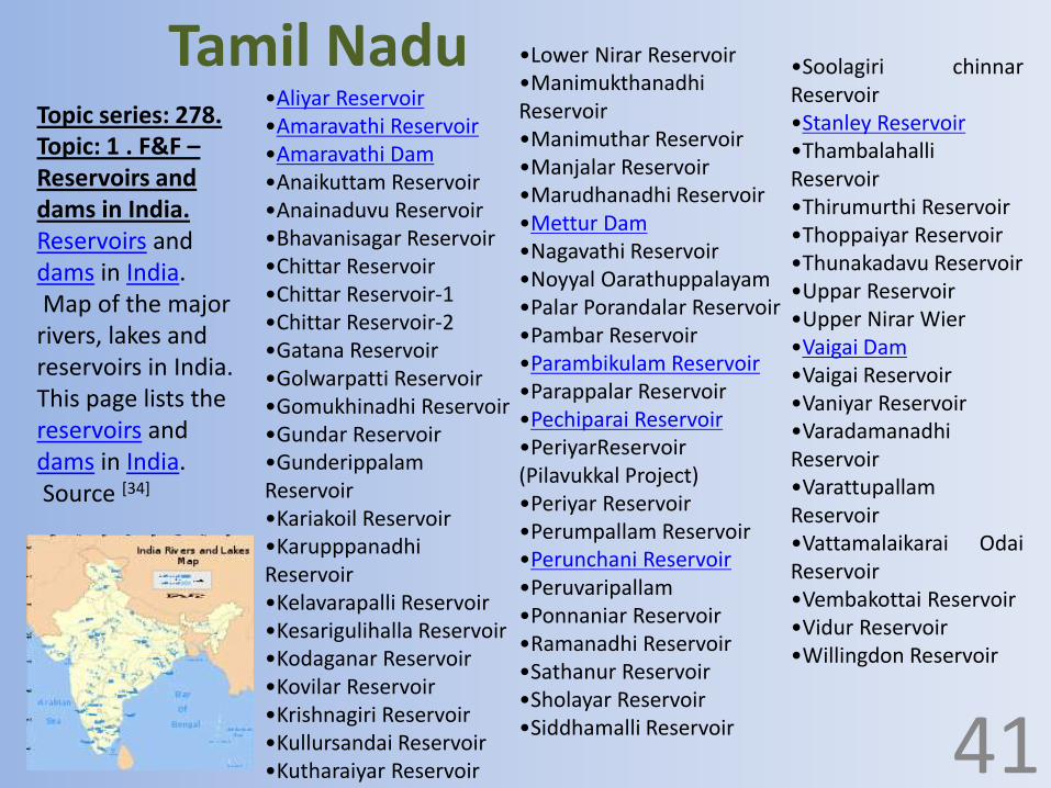
Topic series: 278. Topic: 1 . F&F – Reservoirs and dams in India.
Reservoirs and dams in India.Map of the major rivers,
lakes and reservoirs in India.This page lists the reservoirs and dams in India.Source [34]
•Nagarjuna SagarDam•Srisailam Project•Srisailam Dam•Nizam Sagar•joorala project•rajolibanda dam•kiol sagar•Telugu Ganga•Polavaram dam•Nijam SagarReservoir•Osman Sagar•Sriram SagarReservoir•Lower ManeruReservoir•Himayath SagarReservoir
•Dindi Reservoir•Somasila•Gandipalem Reservoir•Dowleswaram Barrage•prakasam barrage•Tatipudi Reservoir•Inchampalli•Pulichintala•Ellammpalli•Singur Dam•Dummagudem•NagarjunaSagar TailPond•Sunkesula•Musi Reservoir•pothireddy padu•Ramagundam Dam•Pranahita Chevella•Intenuka Muriki KaluvaReservoir•jeri dam 33
Andhra Pradesh

Topic series: 278. Topic: 1 . F&F – Reservoirs and dams in India.
Reservoirs and dams in India.Map of the major rivers, lakes and reservoirs in India.This page lists the reservoirs and dams in India.Source [34]
•Sardar Sarovar Project on Narmadariver•Ukai Dam near Surat•Dharoi Dam on Sabarmati River nearDharoi•Vasana Berej on Sabarmati Rivernear Ahmedabad•Check Dams
34
Gujarat

Topic series: 278. Topic: 1 . F&F – Reservoirs and dams in India.Reservoirs and dams in India.Map of the major rivers,
lakes and reservoirs in India.This page lists the reservoirs and dams in India.Source [34]
•Bhakra Dam on Sutlej river, near Nangal•Gobind Sagar•Maharana Pratap Sagar•Pong Dam Reservoir on Beas River, nearTalwara.•Pandoh Dam on Beas River, near Mandi.•Chamera Dam on Ravi River near Chamba.•Nathpa Dam on Sutlej River near Rampur.Jammu and Kashmir•Salal ProjectJharkhand•Maithon Dam•Chandil Dam on Swarnarekha River nearChandil
35
Himachal Pradesh+ Punjab
Topic series: 278. Topic: 1 . F&F – Reservoirs and dams in India.Reservoirs and dams in India.Map of the major rivers,
lakes and reservoirs in India.This page lists the reservoirs and dams in India.Source [34]
•Hidkal Jalashaya (Dam) across Ghataprabha•Dhupdal Reservior across Ghataprabha•Krishna Raja Sagara Dam•Alamatti Dam across Krishna•Basava Sagara Dam•Linganamakki dam•Supa Dam•Kodasalli Dam•Kadra Dam•Tunga Bhadra Dam•Kabini Reservoir•Harangi Dam•Narayanpur Dam downstream of Alamatti Dam•Garura Dam Krishna River•Hemavathi Reservoir (Gorur Dam)•Naviltheertha Dam across Malaprabha•Nethravathi river•Linganmakki Dam across Sharavathi River•Gajanuru Dam across Tunga river•Lakkavali Dam across Bhadra river 36
Karnataka

Topic series: 278. Topic: 1 . F&F – Reservoirs and dams in India.Reservoirs and dams in India.Map of the major rivers,
lakes and reservoirs in India.This page lists the reservoirs and dams in India.Source [34]
•Banasura Sagar Dam•Malampuzha Dam•Chalakkudy Dam•Peechi dam•Vazhani dam•Mangalam dam•Mattupetty Dam•Kundala dam in Munnar•Parambikulam Dam•Pothundi Dam•Walayar Dam•Idukki arch dam in idukki•Mullaperiyar Dam•Malankara Dam•Neyyar Dam•Siruvani Dam•Meenkara Dam•Kanjhirapuzha•Chulliyar Dam•Jeevana dam 37
Kerala

Topic series: 278. Topic: 1 . F&F – Reservoirs and dams in India.Reservoirs and dams in India.Map of the major rivers,
lakes and reservoirs in India.This page lists the reservoirs and dams in India.Source [34]
•Bansagar•Bargi Dam•Barna Dam•Gandhi Sagar dam•Indirasagar•Madikheda Dam•Narmada Dam Project•Rajghat•Tawa Reservoir•halali dam•kolar dam•kerwa dam
38
Madhya Pradesh

Topic series: 278. Topic: 1 . F&F – Reservoirs and dams in India.Reservoirs and dams in India.Map of the major rivers,
lakes and reservoirs in India.This page lists the reservoirs and dams in India.Source [34]
•MULA Dam, Rahuri - River MULA•Koyna Dam - River Koyna•Jaikwadi•Ujani -River Bhima•Mulshi Dam - River Mula•Khadakwasla - River Mutha•Kolkewadi Dam•Panshet - River Mutha•Radhanagari•Bhatsa•Tansa•Vaitarna•Pawna - River Pawna•Bhandardara•Gangapur Dam, Nashik•Ozarkhed Dam, Nashik•Karanjwan Dam•Nandur Madhmeshwar Dam•Yeldari on Purna River Near Parbhani•Siddheshwar on Purna River Near Parbhani•Manar On River Manar Near Nanded•Girna On River Girna•Chaskaman On River Bhima Near Rajgurunagar•Pravara On River Godavari•Isapur Dam on River Painganga River.•Bhadardara On River Pravara
39
Maharashtra
Topic series: 278. Topic: 1 . F&F – Reservoirs and dams in India.Reservoirs and dams in India.Map of the major rivers,
lakes and reservoirs in India.This page lists the reservoirs and dams in India.Source [34]
•Umiam LakeOrissa•Balimela Reservoir•Hirakud Dam on Mahanadi Rivernear Sambalpur•Balimela Reservoir•Jalaput on Machkund River nearJaypore, Koraput District•Indravati Dam on river Indravati inkalahandi district•Salia dam on river Kharkhari inGanjam District
40
Meghalaya
Topic series: 278. Topic: 1 . F&F –Reservoirs and dams in India.Reservoirs and dams in India.Map of the major
rivers, lakes and reservoirs in India.This page lists the reservoirs and dams in India.Source [34]
•Aliyar Reservoir•Amaravathi Reservoir•Amaravathi Dam•Anaikuttam Reservoir•Anainaduvu Reservoir•Bhavanisagar Reservoir•Chittar Reservoir•Chittar Reservoir-1•Chittar Reservoir-2•Gatana Reservoir•Golwarpatti Reservoir•Gomukhinadhi Reservoir•Gundar Reservoir•GunderippalamReservoir•Kariakoil Reservoir•KarupppanadhiReservoir•Kelavarapalli Reservoir•Kesarigulihalla Reservoir•Kodaganar Reservoir•Kovilar Reservoir•Krishnagiri Reservoir•Kullursandai Reservoir•Kutharaiyar Reservoir
•Soolagiri chinnarReservoir•Stanley Reservoir•ThambalahalliReservoir•Thirumurthi Reservoir•Thoppaiyar Reservoir•Thunakadavu Reservoir•Uppar Reservoir•Upper Nirar Wier•Vaigai Dam•Vaigai Reservoir•Vaniyar Reservoir•VaradamanadhiReservoir•VarattupallamReservoir•Vattamalaikarai OdaiReservoir•Vembakottai Reservoir•Vidur Reservoir•Willingdon Reservoir
•Lower Nirar Reservoir•ManimukthanadhiReservoir•Manimuthar Reservoir•Manjalar Reservoir•Marudhanadhi Reservoir•Mettur Dam•Nagavathi Reservoir•Noyyal Oarathuppalayam•Palar Porandalar Reservoir•Pambar Reservoir•Parambikulam Reservoir•Parappalar Reservoir•Pechiparai Reservoir•PeriyarReservoir(Pilavukkal Project)•Periyar Reservoir•Perumpallam Reservoir•Perunchani Reservoir•Peruvaripallam•Ponnaniar Reservoir•Ramanadhi Reservoir•Sathanur Reservoir•Sholayar Reservoir•Siddhamalli Reservoir 41
Tamil Nadu

Topic series: 278. Topic: 1 . F&F –Reservoirs and dams in India.Reservoirs and dams in India.Map of the major
rivers, lakes and reservoirs in India.This page lists the reservoirs and dams in India.Source [34]
•Govind Ballabh Pant Sagar on Rihand River in Sonbhadra•Kalagarh Dam on Ramganga River in Kalagarh•Parichha Dam on Betwa River in Parichha (Jhansi District).•List of Dams in Lalitpur District, Uttar Pradesh
(A) Matatila Dam constructed during 1952-1964 on Betwa River in LalitpurDistrict, Uttar Pradesh, Length 6.30 km, Height 33.53 Meters, Area 20,720Sq.km., Storage 1132.68 M.c.m(B) Jamni Dam constructed during 1962-1973 on Jamni River in LalitpurDistrict, Uttar Pradesh, Length 6.40 km, Height 19.18 Meters, Area 414Sq.km., Storage 92.89 M.c.m(C) Rohini Dam constructed during 1976-1984 on Rohini River in LalitpurDistrict, Uttar Pradesh, Length 1.65km, Height 15.50 Meters, Area 44 Sq.km.,Storage 12.12 M.c.m(D) Shahzad Dam constructed during 1973-1992 on Shahzad River inLalitpur District, Uttar Pradesh, Length 4.16 km, Height 18.00 Meters, Area514 Sq.km., Storage 130.00 M.c.m(E) Govind Sagar Dam constructed during 1947-1953 on Shahzad River inLalitpur District, Uttar Pradesh, Length 3.60 km, Height 18.29 Meters, Area368 Sq.km, Storage 96.8 M.c.m. (F) Sajnam Dam constructed during 1977-1990 on Sajnam River in LalitpurDistrict, Uttar Pradesh, Length 5.15 km, Height 18.78 Meters, Area 290Sq.km., Storage 83.50 M.c.m(G) Sukma-Dukma Dam a below water construction on Betwa River nearJhansi District, Uttar Pradesh, Length 2.15 km, Height 20.78 Meters 42
Uttar Pradesh

Topic series: 278. Topic: 1 . F&F – Reservoirs and dams in India.Reservoirs and dams in India.Map of the major rivers,
lakes and reservoirs in India.This page lists the reservoirs and dams in India.Source [34]
•Tehri dam•Dhauli ganga dam•Sriram Sagar•Devadula Lift Irrigation Project•Kaddam•Manjira Reservoir•Lower Tirna•Purna•Upper PenGanga•Lower Dudhana•Jayakwadi Dam•Bhandara Reservoir•Mula Reservoir•Upper Pravara•Upper Indravati Project•Godavari Canal•Upper WainGanga•Majalgaon irrigation project is located in theGodavari river basin in the state ofMaharashtra. 43
Uttarakhand

Topic series: 278. Topic: 1 . F&F – Reservoirs and dams in India.Reservoirs and dams in India.Map of the major rivers,
lakes and reservoirs in India.This page lists the reservoirs and dams in India.Source [34]
•Panchet DamDam projects•Narmada Dam Project•Banasura Sagar Dam - Banasurasagar Project •Noyyal River - Tanks System •Farakka Barrage .Source [34]
44
West Bengal

Topic series: 278. Topic: 1 . F&F – Reservoirs and dams in India.Reservoirs and dams in India.Map of the major rivers,
lakes and reservoirs in India.This page lists the reservoirs and dams in India.Source [34]
Optimum level of water in mostof the reservoirs in all theseasons:All the dams and the areaswhich are below the level of500mts AMSL except in thestates of Jammu and Kashmir,North eastern states will get thewater form RCS and theprinciple feeders will be theGanga and the Yamuna.
45

Topic series: 278. Topic: 1 . F&F – Reservoirs and dams in India.Reservoirs and dams in India.Map of the major rivers,
lakes and reservoirs in India.This page lists the reservoirs and dams in India.Source [34]
Optimum level of water in mostof the reservoirs in all theseasons:All the dams and the areaswhich are below the level of300mts AMSL except in thestates of Jammu and Kashmir,North eastern states will get thewater form RCS and theprinciple feeders will be theBrahamaputra for the RCS.
45

Topic series: 278. Topic: 1 . F&F – Reservoirs and dams in India.Reservoirs and dams in India.Map of the major rivers,
lakes and reservoirs in India.This page lists the reservoirs and dams in India.Source [34]
Optimum level of water inmost of the reservoirs in all theseasons:All the dams and the areaswhich are below the level of900mts AMSL in south Deccanplatue especially the southerndistricts of Karnataka, westerndistricts of Andhra Pradesh andTamilnadu will get the waterfrom the RCS and the principlefeeders will be the River Kaveri.
46

Topic series: 278. Topic: 1 . F&F – Reservoirs and dams in India.Reservoirs and dams in India.Map of the major rivers,
lakes and reservoirs in India.This page lists the reservoirs and dams in India.Source [34]
Optimum level of water inmost of the reservoirs in all theseasons:All the dams and the areas whichare below the level of 800mts AMSLin north India like states of Punjab,Haryana, Himachal Pradesh, Delhi,northern district of Uttarpradesh,Bihar which are north to the courseof Ganga and Yamuna will get thewater from the RCS and theprinciple feeders will be the Gangaand Yamuna Rivers.
46

Sources:[34] Britannica Concise Encyclopedia, answers.com, Wikipedia.[37] Deccan herald, Mangalore, Friday, december31, 2010. AndPrajavani Kannada daily news paper, Mangalore, Friday,December, 31, 2010.
50

Section 5:Reticular canal system for interlinking Indian rivers;
Chapter 8: Facts and figures related to Drought in India:
Let us know some thing on the drought in India.
51
Low rainfall during the last two years has
caused severe drought conditions in 11 Indian
States. An estimated 130 million people - 15
percent of the population - in more than
70,000 villages and 230 urban centers are at
risk. Source [52]
Topic series: 295Topic: 2 . F&F – More than 100 million are at risk due to drought.
47
India: More than 100 millon are at risk:

Drought fuels, India farmer fears.
Maharashtra is one of India's most
prosperous states - but despite
that, farmers have been
committing suicide for the past
three years in despair at crop
failure, drought and Growing
indebtedness.
Source [52]
Topic series: 304 Topic: 11 . F&F –Without rain most of the crops will be destroyed.
48
Without rain most of the
crops will be destroyed.

Topic series: 304 Topic: 11 . F&F –Without rain most of the crops will be destroyed.
Water for agriculture will beavailable in sufficient quantity allthe time of the year. Thus RCSwill bring an end to the farmer’ssuicide due to loss in agriculture.
49
Water scarcity and loss inagriculture will never occur withRCS in any part of India.
Farmers need not wait for rain inany season of the year.
Source [54]
Topic series: 308 Topic:17 . F&F – Water, the stuff of life, has become the source of dangerous friction.
50
Seven percent of the world's population has not enough water.
By 2050, this will be 70 percent.
Our planet has 1,400 million million million liters of water: 100 billion liters a head.
But, 97 percent is salty and much of the rest is trapped underground or stored as polar ice.
Only 0.8 percent of the Earth's water is accessible and drinkable: about one billion billion liters.
It is enough on an average.
But some countries have too much. Others have too little.

Topic series: 308 Topic:17 . F&F – Water, the stuff of life, has become the source of dangerous friction.
The word ‘war for water’ needs to be understoodefficiently.
51
The nation need to understand the seriousness behind thisissue and act accordingly for the supply of water to all theparts of the country on an emergency basis.
If we take rest for few years by not taking any seriousthought to get the water for all the people of the nation
now and if we plan the same after some years by that
time we may be in a position to do the project but theinternational laws may stop us not to carry out any suchprojects and the people of the nation is going suffer fromthe deficiency.

Topic series: 309Topic: 16 . F&F – Types of drought.
The areas of the India which are colored blue are flood prone that does not mean the flood is due to rain over that area, but it is due to the convergence of river water over there.
52
With RCS all the drought prone states of the India like Rajastan, Haryana, Chandigarh, Delhi, Panjab, Andrapradesh and Rayalseema, Karnataka, Tamilnadu, and Kerala can be irrigated well.

Topic series: 309Topic: 16 . F&F – Types of drought.
With RCS all floodwater will be divertedat their tributary level(at higher levels) andthus more waterentering to the areascolored blue will beavoided and this waterwill be supplied to thedrought prone areaswhich are coloredbrown in the map.
53

Topic series: 310Topic:17 . F&F – National commission on agriculture classifies drought.
With RCS we can eradicate all types ofdrought permanently.
54
We should understand that the drought is not the newproblem and it will be there only for few years and thengoes off.
This is the human sufferings existing from many centuriesand the severity has increased as the population increased.

Shortage of drinking water and starvation for food
are the other consequences that emerge. Fodder
problem drives away the animals to distress sales.
Thus climate is the initial causative factor for
drought; the implications are manifested by human
interactions with the situation.
Source [57]
Topic series: 311 Topic:18 . F&F – Drought - the silent threat to rural economy.
55
[Drought – the silent threat to rural
economy;
Topic series: 311 Topic:18 . F&F – Drought - the silent threat to rural economy.
Thus if we create RCS all the farmers will have betterincome in their own village and will not migrate.
56
Since agriculture is the main profession of the nation andthe immediate victim of the drought disaster is agriculture.
We need to take measures to eradicate the droughtimmediately on emergency basis and the solution for this isthe RCS.
Since the Drought causes damage to the crop and thus thefarm employment, the marginal farm employs are thepeople who are going to affect at the first and leads tomigration to urban areas in search of employment.

Sources:[45] India-Introduction\Article Detail - Science News - QJ_NET.mht.[46] Internet: Drought disasters – UNICEF.[47] Drought in India - Wikipedia, the free encyclopedia.mht.[48] Internet: Drought-proofing India.[49] Internet: Environmental issues in India - Wikipedia, the free encyclopedia.[50] Internet: Welcome to NRSC – Drought. National Remote Sensing Centre, ISRO/DOS,Govt. of India. Recent update in Feb-2009. 2006-2008 National Remote Sensing Centre,ISRO/DOS, Govt. of India. Recent update in Feb-2009. Designed & Developed by CMCLimited.http://dsc.nrsc.gov.in:14000/DSC/Drought/index.jsp?include1=homelink1_b1.jsp&&include2=homelink1_b2.jsp# Welcome to NRSC - Drought.mht.[51] Internet: Welcome to NRSC – Drought.[52] http://news.bbc.co.uk/2/hi/south_asia/3916559.stm By Zubair Ahmed BBCcorrespondent in Maharashtra.[53]India-Introduction\Drought-proofing India.mht.[54] Famine.mht.[55] Types of Drought in India.mht.[56] Welcome to NRSC - Drought1.mht.[57]Welcome to NRSC - Drought2.mht.[58] Welcome to NRSC - Drought3.mht.[59] Welcome to NRSC - Drought4.mht.
57

Topic series: 315Topic: 2. F&F – Canals of the United Kingdom.
The canals of the RCS can also be used for transportation ofmaterials and it becomes the cheap way of transportationall across the nation.
58
The canals of the RCS can be utilized for various purposeslike for recreation (boat house / holiday packages) since itwill be with the nice sceneries.

Topic series: 316Topic:3 . F&F –DUKE OF BRIDGEWATER'S UNDERGROUND CANAL AT WORSLEY.
In RCS underground canals are not done frequently.
59
The water which comes out of the underground canal mayhave different color due to contamination with somechemical e.g. Iron Oxide?

Topic series: 317 Topic: 4 . F&F – It would be possible to use canals to link the four great rivers of England.
According to me ‘RCS’ will fulfill our need in the fields ofagriculture, industry and for domestic purposes.
60
Interlinking rivers for the better utilization of river water asthe demand for water is increasing with the increasedpopulation is not a new thing.
But we have to identify the most suitable ways for ournation depending on the geography and water availability inthe nation.

Sources:[60] BUILDING BIG Databank UndergroundCanal.htm.[61] Canals of the United Kingdom - Wikipedia,the free encyclopedia.htm.[62] Duke of Bridgewater's Underground Canal atWorsley - Introduction1.htm. 26.1.02.[63] List of canal tunnels in the United Kingdom -Wikipedia, the free encyclopedia.htm.
61
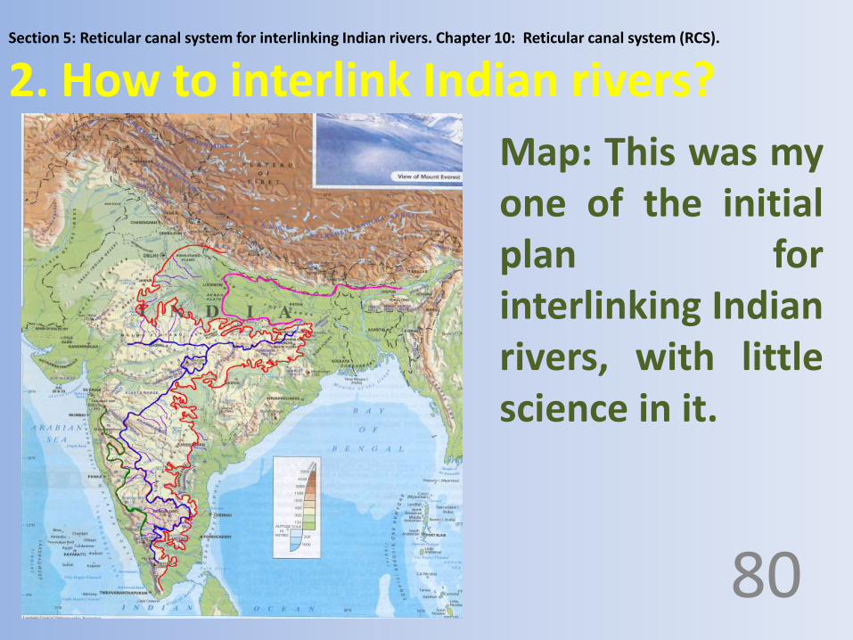
Section 5: Reticular canal system for interlinking Indian rivers. Chapter 10: Reticular canal system (RCS).
2. How to interlink Indian rivers?
80
Map: This was myone of the initialplan forinterlinking Indianrivers, with littlescience in it.

Topic series: 320 Topic 3: Introduction to RCS and Definitions in RCS.
This makes all the states coming below that primary canalto have equal access to the water and no state need not askanother state to release that water.
82
With RCS every drop of water is accessible by all the statesif that drop of rain falls above the level of a particular PC.
Water will automatically distributes equally all along thecourse of the canal and the level of the water changes in theprimary canal.

Topic series: 320 Topic 3: Introduction to RCS and Definitions in RCS.
RCS is like a bus, new passengers gets in and fewpassengers gets down from the bus.
83
RCS is like a post office; it receives letters from various postboxes and distributes it to various houses.
RCS is like a college, new batch of students enters thecollege and the students who completes the course goes outof the college,
RCS is like a bank, credit comes from one side and debitgoes on other side,

Topic series: 320 Topic 3: Introduction to RCS and Definitions in RCS.
‘If all of us make up our mind, it is definatly possibleto irrigate the entire land and the nation’- to growthe crops and to drink good water.
84
We know earth has got plenty of water over it, but itis very much unequally distributed.

Topic series: 320 Topic 3: Introduction to RCS and Definitions in RCS.
All the naturally flowing water pathways, the canals that wecreate to interlink the rivers, the various canals that wecreate to distribute the water from these water pathwayswill look like the web of canals in the form of reticulum withall the major - minor and natural - artificial water pathways,thus the name Reticular Canal system for the system ofInterlinking Indian rivers.
85
Definition of Reticular canal system:
It is the system of collecting the water from variousrivers starting from Ganga and ending at Chittar, anddistributing the water according to the need for theentire India (J&K is not focused at this stage).

Topic series: 320 Topic 3: Introduction to RCS and Definitions in RCS.
RCS of India.
86
Topic series: 320 Topic 3: Introduction to RCS and Definitions in RCS.
But the cost involved in interlinking the rivers, the length,the structures we need to construct to bypass thegeographical variation and so on, need to be considered andit should be environmental friendly, economically feasibleand should be practical.
87
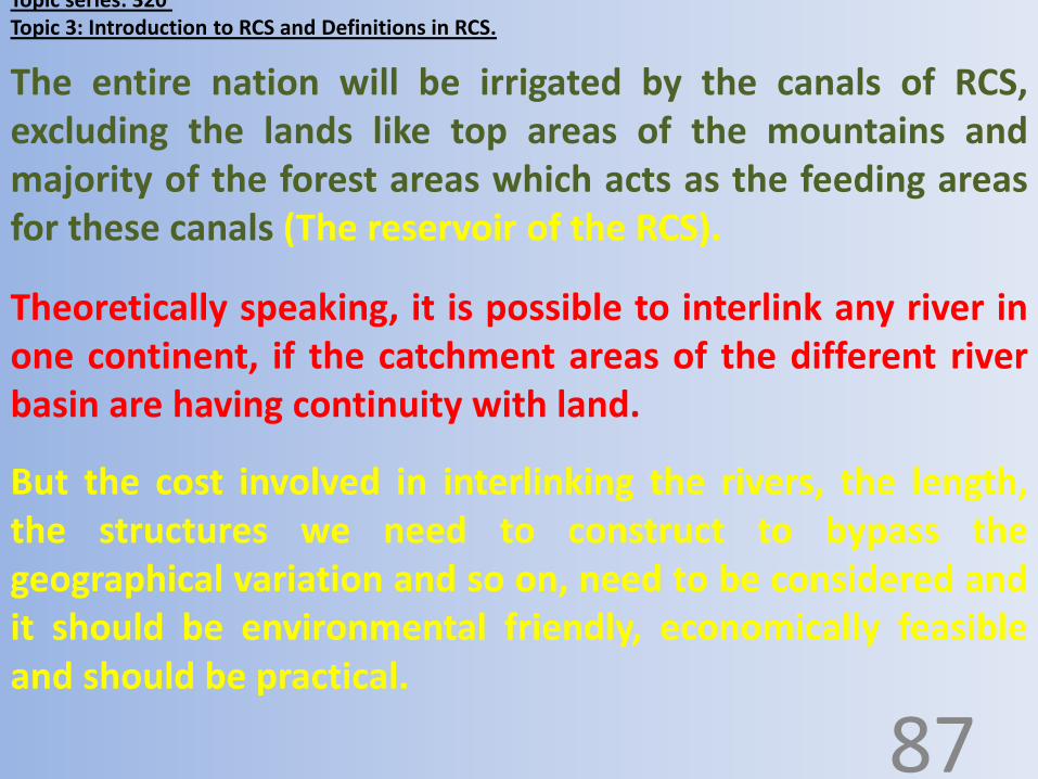
The entire nation will be irrigated by the canals of RCS,excluding the lands like top areas of the mountains andmajority of the forest areas which acts as the feeding areasfor these canals (The reservoir of the RCS).
Theoretically speaking, it is possible to interlink any river inone continent, if the catchment areas of the different riverbasin are having continuity with land.

Topic series: 320 Topic 3: Introduction to RCS and Definitions in RCS.
RCS of India in the wor ld.
88

Topic series: 320 Topic 3: Introduction to RCS and Definitions in RCS.
4. Quaternary canal.
89
The canals created in RCS will be classified as,
1. Primary canal.
2. Secondary canal.
3. Tertiary canal.

Topic series: 320 Topic 3: Introduction to RCS and Definitions in RCS.
4. Quaternary canal: The canal which drains water from thetertiary canal.A. Natural quaternary canal e.g. Rivers and present day dry water paths (Seasonal).B. Artificial quaternary canals, e.g. Created canals. 90
Types of canal that we are going to see in this system;
1. Primary canal : The canal which connects two adjacent rivers.A. Natural primary canal, e.g. Rivers and present day dry water paths (Seasonal) .B. Artificial primary canal , e.g. Created canals.
2. Secondary canal : The canal which drains water from theprimary canal.A. Natural secondary canal e.g. Rivers and present day dry water paths (Seasonal) .B. Artificial secondary canal , e.g. Created canals.
3. Tertiary canal : The canal which drains water from the secondarycanal.A. Natural tertiary canal, e.g. Rivers and present day dry water paths (Seasonal).B. Artificial tertiary canal, e.g. Created canals.

Topic series: 320 Topic 3: Introduction to RCS and Definitions in RCS.
River elevator: It is the artificial structure created across the flow ofthe river to elevate the top flowing level of the river, to make the riverto flow down / at the same level, higher than the original level in thecourse we require.
91
Some terminologies we use in this system:

Topic series: 320 Topic 3: Introduction to RCS and Definitions in RCS.
River elevator: This is constructed across the river.
92

Topic series: 320 Topic 3: Introduction to RCS and Definitions in RCS.
Canal elevator: To maintain the needed top water level in the canalat places where we do not get the required earths height.
93

Topic series: 320 Topic 3: Introduction to RCS and Definitions in RCS.
Canal elevator: This is constructed along the course ofcanal on one side. It looks like a ‘node’ from the top.
94

Topic series: 320 Topic 3: Introduction to RCS and Definitions in RCS.
Direct canal connectors: These are the canal created by digginglittle deep to avoid circumscribing an elevated area and thus savinglarge length of the unnecessary canal.
95

Topic series: 320 Topic 3: Introduction to RCS and Definitions in RCS.
U tube: This is a closed canal system in the shape of U with waterreceiving end at a higher level than the water discharging end thusthe water is going to flow from one end of the U tube to anotherend by Gravity.It is also possible to create the U tube with both the ends at thesame level expecting bi directional flow.
96

Topic series: 320 Topic 3: Introduction to RCS and Definitions in RCS.
Bi dam: (two dam) the wall like parallel structures constructedalong the course of the canal at places where we do not get therequired earths height. The parallel walls will be constructed oneither the sides of the future water flowing path.
97

Topic series: 320 Topic 3: Introduction to RCS and Definitions in RCS.
Bi dam - FPC1 start to Gambhir500-D1-431.
98

Topic series: 320 Topic 3: Introduction to RCS and Definitions in RCS.
Y Bi dam: Bi dam with the diversion path in the shape of Y.
99

Topic series: 320 Topic 3: Introduction to RCS and Definitions in RCS.
Aqua duct: Water path way sitting on the pillars,so that the water from another side will flowthrough the structure.
100

Topic series: 320 Topic 3: Introduction to RCS and Definitions in RCS.
Flat canal system (Bidirectional flow of water): This is thecanal with the same level on either the ends. Here theactive flow of water from one end of the canal to anotherend is not targeted, but filling of water from any point(by any river /source) will raise the level of the water allalong the course of the canal, so that we can dischargethe water from any part of the canal all along the courseaccording to our requirement based on the principle ofbidirectional flow. 101
Flow based canals (Unidirectional flow of water): Wherethe starting point of the canal will be at a higher levelthan, the ending point, thus the water will be flowingfrom the higher level to the lower level in one direction.
Topic series: 321Topic 4: Principles of RCS.
At all the levels a controlling gate will be there.
102
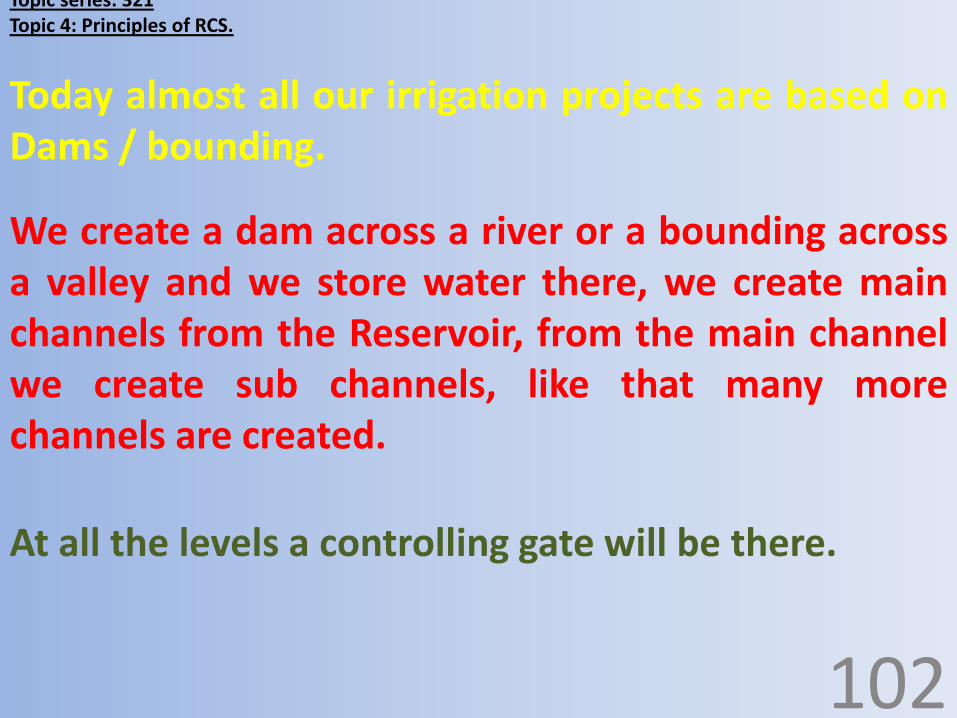
Today almost all our irrigation projects are based onDams / bounding.
We create a dam across a river or a bounding acrossa valley and we store water there, we create mainchannels from the Reservoir, from the main channelwe create sub channels, like that many morechannels are created.
Topic series: 321Topic 4: Principles of RCS.
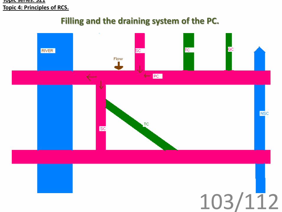
Filling and the draining system of the PC.
103/112

Topic series: 321Topic 4: Principles of RCS.
Filling and the draining system of the Primary channel:
110
The quantity of water at any point/place in the primary channel depends on the quantity of flow of water in the primary channel itself from the proximal canal at the higher level, the quantity of flow from the filling system from the upper level, the quantity of outflow from the canal itself at the distal canal and the quantity of outflow from the draining system to the lower levels.
For a primary channel water will be filled from the natural and artificial water paths at different points from the higher level, and on the other side, water is utilized/drained at different points in to various artificial and natural flow system.

Topic series: 321Topic 4: Principles of RCS.
Any excess flow in the Primary channel will beflown in to the natural system or it may reach theother primary channel at a lower level.
111
The water level rises in the primary canal, if theinput is more and the output (utilization) is less andvice versa.
The water level/flow will be maintained steady ifthe input equals the output.

Topic series: 321Topic 4: Principles of RCS.Source of water:
113Surface water is water of ponds, lakes, reservoirs, rivers,sea.
The Sources of water are Rain water, underground water,and surface water.
The rain water is very much unpredictable, both floodsand droughts are seen in the past.
The underground water levels are variable at differentplaces. It needs the surface water to sink in to the deeperlayers of the soil. And we also know that the ground waterlevel is decreasing day by day, and most of the open/borewells are empty today.

Topic series: 321Topic 4: Principles of RCS.
Now it is better to create the channel systems in such away that it utilizes the surface water to the maximumextent, so that least water reaches the sea directly.
114
So, when we are creating RCS it is better to depend on thewater source that is continuous over all the 12 months,potable for drinking, sufficient for irrigation and industry.
INDIA is blessed with plenty of rivers that are flowing allthe 12 months, and most of the water is reaching the seawithout any useful utility, for example 70% of the water ofGANGA RIVER reaches the sea.
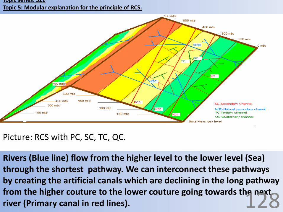
Topic series: 322Topic 5: Modular explanation for the principle of RCS.
Rivers (Blue line) flow from the higher level to the lower level (Sea) through the shortest pathway. We can interconnect these pathways by creating the artificial canals which are declining in the long pathway from the higher couture to the lower couture going towards the next river (Primary canal in red lines).
Picture: RCS with PC, SC, TC, QC.
128

Topic series: 322Topic 5: Modular explanation for the principle of RCS.
Picture: The same principle which are explained in the previousmodules will hold good even for the canals which are created in thesame couture, where the water will be distributed all along the canalby rise in the level of water as the water fills in to the Primary channel,instead of flow towards one side.
129

Topic series: 322Topic 5: Modular explanation for the principle of RCS.
Instead of creating the canals which aredeclining in their course from the startingpoint to ending point as they interlink therivers one by one, it is also possible to interlinkthe rivers by creating the canals at the samelevel, thus the level of the water will raise asthe water fills in to the canal instead of theflow in one direction.
130

Topic series: 322Topic 5: Modular explanation for the principle of RCS.
If we want to store the water, when there is a need, we can utilize the water of the RCS for filling the natural/ artificial reservoirs (blue and red dotted area respectively), dams, bounding and others.
Picture: We can store the water by utilizing the water of the RCS forfilling the natural/ artificial reservoirs.
131

Topic series: 322Topic 5: Modular explanation for the principle of RCS.
The evenly looking prismatic module represents thedifferent land levels as seen in this map, and theactual level ranges are shown in inside picture. Andthe probable primary channels are shown in the redline, and each channel is flowing at a level range.
Ex. PC1 at 300-450mts AMSL, PC2 at 450-600mtsAMSL, PC3 at 600-750mts AMSL, PC4 at 150-200mtsAMSL.
132

Topic series: 322Topic 5: Modular explanation for the principle of RCS.
Map: The evenlylooking prismaticmodule representsthe different landlevels of the earth.
133

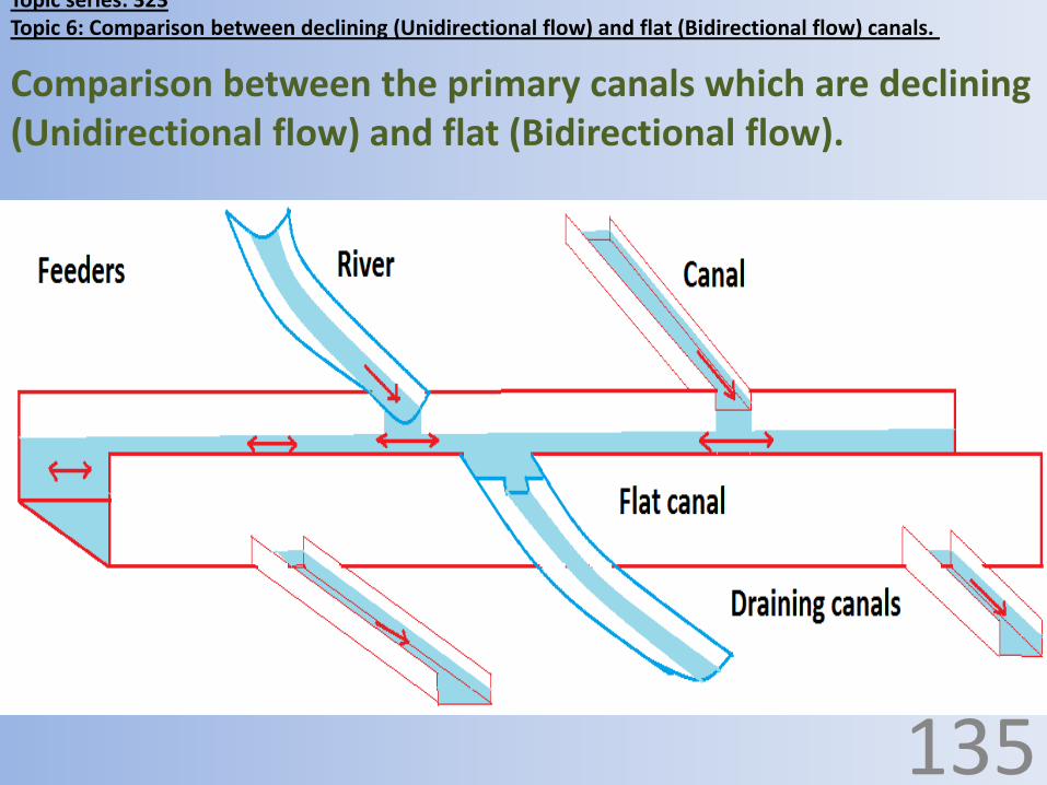
Topic series: 323Topic 6: Comparison between declining (Unidirectional flow) and flat (Bidirectional flow) canals.
Comparison between the primary canals which are declining (Flow based / Unidirectional flow) and flat (Bidirectional flow).
134
Topic series: 323Topic 6: Comparison between declining (Unidirectional flow) and flat (Bidirectional flow) canals.
Comparison between the primary canals which are declining (Unidirectional flow) and flat (Bidirectional flow).
135

Comparison between the primary canals which are declining (Unidirectional flow) and flat (Bidirectional
flow):
97135

Topic series: 323Topic 6: Comparison between declining (Unidirectional flow) and flat (Bidirectional flow) canals.
Declining Primary canals
(Unidirectional flow)
Flat primary canals
(Bidirectional flow)
The starting point of the
canal will be higher than the
ending point in terms of mts
AMSL.
The starting and the ending
points of the canal are at
the same level in terms of
mts AMSL.
Comparison between the primary canals which are declining (Unidirectional flow) and flat (Bidirectional flow):
136

Declining Primary canals
(Unidirectional flow)
Flat primary canals (Bidirectional
flow)
Topic series: 323Topic 6: Comparison between declining (Unidirectional flow) and flat (Bidirectional flow) canals.
There is a flow
gradient in the
course of the
canal.
There is no flow gradient, only
the level of water in the canal
will rise as more water enters
the canal at any point
all along the course
of the canal.
137

Declining Primary canals
(Unidirectional flow)
Flat primary canals (Bidirectional flow)
Topic series: 323Topic 6: Comparison between declining (Unidirectional flow) and flat (Bidirectional flow) canals.
The water flows
from the higher
end to the lower
end by gravity.
Water will not be flowing in the canal,
instead every drop of water which
enter in to the canal will make the
water level in the canal to rise all
along its course and every drop of
water which leaves the canal will
make the level of water to decrease
all along its course.
138

Declining Primary canals
(Unidirectional flow)
Flat primary canals (Bidirectional
flow)
Topic series: 323Topic 6: Comparison between declining (Unidirectional flow) and flat (Bidirectional flow) canals.
Water pools at the
lower end if there is less
flow of water in the
canal, thus only the
people at the lower end
will be benefited in the
absence of the gates in
between, in the course
of the canal.
There is no pooling of
water at the ends or at
any place in the canal,
every drop of water will
be equally distributed
and equally accessible
to all the places below
the level of the canal.
139
Declining Primary canals
(Unidirectional flow)
Flat primary canals (Bidirectional
flow)
Topic series: 323Topic 6: Comparison between declining (Unidirectional flow) and flat (Bidirectional flow) canals.
Law need to be enforced
to decide how much
water to be flown in
each gate.
Only one law is sufficient
to maintain the water in
the canal that is, ‘at no
place water should enter
the sea, if there is some
place called ‘drought
prone’.
140

Declining Primary canals
(Unidirectional flow)
Flat primary canals (Bidirectional
flow)
Topic series: 323Topic 6: Comparison between declining (Unidirectional flow) and flat (Bidirectional flow) canals.
Lower canal areas
are prone for
damage as the
pressure in lower
end of the canal is
always more.
The entire length of the
canal will have the same
possibility of getting the
damage and the damages
will be less as the
pressure distributes
equally over all the gates.
141

Declining Primary canals
(Unidirectional flow)
Flat primary canals (Bidirectional flow)
Topic series: 323Topic 6: Comparison between declining (Unidirectional flow) and flat (Bidirectional flow) canals.
If there is damage to
the gates in the course
of the canal, then the
lower level canal will
be over flown with the
water and the lower
canal gates will have
more pressure.
If there is some damage to the
gates in the course of the canal,
then also, the water on either the
sides of the canals will be at the
same level, nothing like entering
more water from higher side to
lower side will happen, but the
level of water in the FPC will
decrease if there is damage to the
gates of the out flowing canals.
142

Declining Primary canals
(Unidirectional flow)
Flat primary canals (Bidirectional
flow)
Topic series: 323Topic 6: Comparison between declining (Unidirectional flow) and flat (Bidirectional flow) canals.
This canal will not act as
the reservoir for the water
even thought there is lot of
space in the canal available
to accommodate the water,
as all the water tends to
pool in the lower end. The
actual capacity of the canal
will be less than the
structural capacity.
This canal will act like a better
reservoir of water in its entire
course, with rain any where
above its level, thus the actual
and the structural capacity will
correspond. There will not be
things like more height of water
at one end and less height of
water at another end or no
water at another end.
143

Declining Primary canals
(Unidirectional flow)
Flat primary canals (Bidirectional
flow)
Topic series: 323Topic 6: Comparison between declining (Unidirectional flow) and flat (Bidirectional flow) canals.
Maintenance cost will be more as
these canals are always flowing
with water.
The complications related to flow
of water like erosion, removing
the top soil which forms the bed
and the walls of the canal and
dumping them in the lower
canal, thus the lower canal
gradually filling with silt over a
period are common.
There is no active flow of water in
the canal, except for the rise and
drop in the level of water, thus
the damage related to flow will
not occur.
Erosion will be less with FPC. The
deposition of silt may be more on
either the sides of the point
where the river enters the FPC,
this phenomenon will be seen at
all the points where the river
enters or crosses the FPC.
144

Declining Primary canals
(Unidirectional flow)
Flat primary canals (Bidirectional
flow)
Topic series: 323Topic 6: Comparison between declining (Unidirectional flow) and flat (Bidirectional flow) canals.
Silting at the lower ends of the
canal makes the capacity of the
canal to decrease over a period
of time which leads to over flow
of water.
These canals are more prone for
damage, by the flowing water
especially in the curves, that to
the canal wall which is on the
low land side.
Since the water distributes
simultaneously all along the
length of the canal, the silt
particles mixed with the water
will also distributes all along the
course of the canal. Thus one
segment of canal completely
filling with the silt and thus
obstructing the flow of water will
not occur.
144

Declining Primary canals
(Unidirectional flow)
Flat primary canals (Bidirectional flow)
Topic series: 323Topic 6: Comparison between declining (Unidirectional flow) and flat (Bidirectional flow) canals.
If there is rain in the
lower canal area,
then the upper
canal area will not
get the benefit.
Rain any where above the level of
the canal will fill the canal equally,
which is accessible to all the lands
which is below its level. Thus both
south , east, west and north part of
the India will get the water if there
is rain in the south , east, west and
north in the limits of the catchment
areas of the canal above the level of
the FPC.145

Declining Primary canals
(Unidirectional flow)
Flat primary canals (Bidirectional
flow)
Topic series: 323Topic 6: Comparison between declining (Unidirectional flow) and flat (Bidirectional flow) canals.
The ‘reservoir surface’
(Catchment area) is less at the
beginning of the PC and it is not
constant in its course.
The reservoir surface in terms
of square kilometers is going
to increase as the canals comes
to the lower side but not more
than the FPC system except at
the end.
The ‘reservoir surface’ (Catchment
area) is not going to change at any
point in the course of the canal
and it is constant for that
particular FPC.
The reservoir surface in terms of
square kilometers remains the
same all along the course of the
canal and even at the ends, thus
receives more water at any point
of the canal.
145

Declining Primary canals
(Unidirectional flow)
Flat primary canals (Bidirectional
flow)
Topic series: 323Topic 6: Comparison between declining (Unidirectional flow) and flat (Bidirectional flow) canals.
The canal comes closer to the
coastal areas as the course
comes to the south and thus
there is a possibility that many
areas of agricultural land may
not get the water of the primary
canal in lower canal areas (in
south India).
Since the PC is going to decline
along its course, we will not get
better height of water fall for
establishing the hydro electrical
projects.
The geographical variations may
be present in terms of distance,
but the canal will not go closer to
the coastal area unlike the
declining canal. Thus more land
suitable for agriculture will get
the water from the FPC.
Since the FPC are at the higher
level than the PC all along its
course and even at its ends, thus,
more hydro electrical projects
can be established with FPC
system. 146

Declining Primary canals
(Unidirectional flow)
Flat primary canals (Bidirectional
flow)
Topic series: 323Topic 6: Comparison between declining (Unidirectional flow) and flat (Bidirectional flow) canals.
The cost of creation
remains the same for
both the types of the
canal as the size of the
canal remains the same
in both.
The cost of creation
remains the same for
both the types of the
canal as the size of the
canal remains the same
in both.
147

Declining Primary canals
(Unidirectional flow)
Flat primary canals (Bidirectional
flow)
Topic series: 323Topic 6: Comparison between declining (Unidirectional flow) and flat (Bidirectional flow) canals.
There is only north to
south flow; south to
north flow or south to
west flow is not
possible.
There is bi directional
flow, thus even the rain
in the south can supply
water to the north, and
vice versa.
148

Declining Primary canals
(Unidirectional flow)
Flat primary canals (Bidirectional
flow)
Topic series: 323Topic 6: Comparison between declining (Unidirectional flow) and flat (Bidirectional flow) canals.
All the states are not
equally accessible for
every drop of water
present in the canal.
All the states, which
comes below the level of
the canals are equally
accessible for every drop
of water without much
intervention of law in it.
149

Declining Primary canals
(Unidirectional flow)
Flat primary canals (Bidirectional
flow)
Topic series: 323Topic 6: Comparison between declining (Unidirectional flow) and flat (Bidirectional flow) canals.
Effective monitoring and
administration to
distribute the water is
required as it is
unidirectional.
Monitoring and
administration of the
distribution system is
easy as compared to PC,
as it is bidirectional.
150

Declining Primary canals
(Unidirectional flow)
Flat primary canals (Bidirectional
flow)
Topic series: 323Topic 6: Comparison between declining (Unidirectional flow) and flat (Bidirectional flow) canals.
This is a good method to
utilize the water
effectively which is
simply reaching the sea
leaving many areas of
land as drought prone,
but not better than FPC
system.
This method is better
than the declining PC,
and all the water which
is generated above the
level of the canal can be
effectively utilized.
151
Declining Primary canals
(Unidirectional flow)
Flat primary canals (Bidirectional
flow)
Topic series: 323Topic 6: Comparison between declining (Unidirectional flow) and flat (Bidirectional flow) canals.
The nation can go for it
to prevent drought and
flood. Why not to think
about the system which
is better than this
system.
The nation can go for it
to prevent drought and
flood. And this is one of
the best methods of
interlinking the rivers as
per my present
knowledge and thinking.
152

Section 5: Reticular canal system for Interlinking Indian rivers:
Chapter 1: Color pictures of RCS.Topic series: 194.
Topic: 1. Few color pictures of RCS.
153

•RETICULAR CANAL SYSTEM: RCS OF INDIA IN THE WORLD.
154

•‘HIMALAYA’ TO ‘ARAVALLI – VINDYA’ SHIFT OF WATER 950 – 500.
155

•BIDIRECTIONAL FLOW BETWEEN ‘ARAVALLI – VINDYA’ IN NORTH TO ‘CARDOMOM HILLS’ IN THE SOUTH 500:
156

•GANGA RIVER ELEVATOR 950:
157

5. GANGA UPPER CANAL 950 – 930:
158

6. GANGA U TUBE 930 – 870:
159

7. YAMUNA UPPER CANALL 870 – 830 – 800:
160

•YAMUNA U TUBE 800 – 700:
161

9. FLAT PRIMARY CANAL 1 – 500:
162

10. FLAT PRIMARY CANAL 2 – 900.
163

11. FLAT PRIMARY CHANNEL 4 RIVER POINTS WITH FPC 1 & 2:
164