Embed Size (px)
Citation preview
The above provides the local details in respect of the SMP-wide policy presented in the preceding sections of this Plan document. These details must be read in the context of the wider-scales issues and policy implications, as reported therein.
Severn Estuary SMP2 Review – Final Report
1
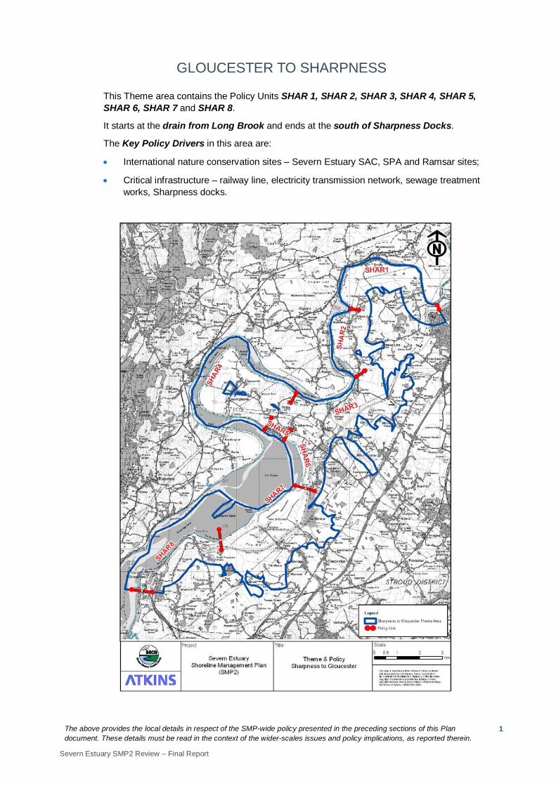
GLOUCESTER TO SHARPNESS
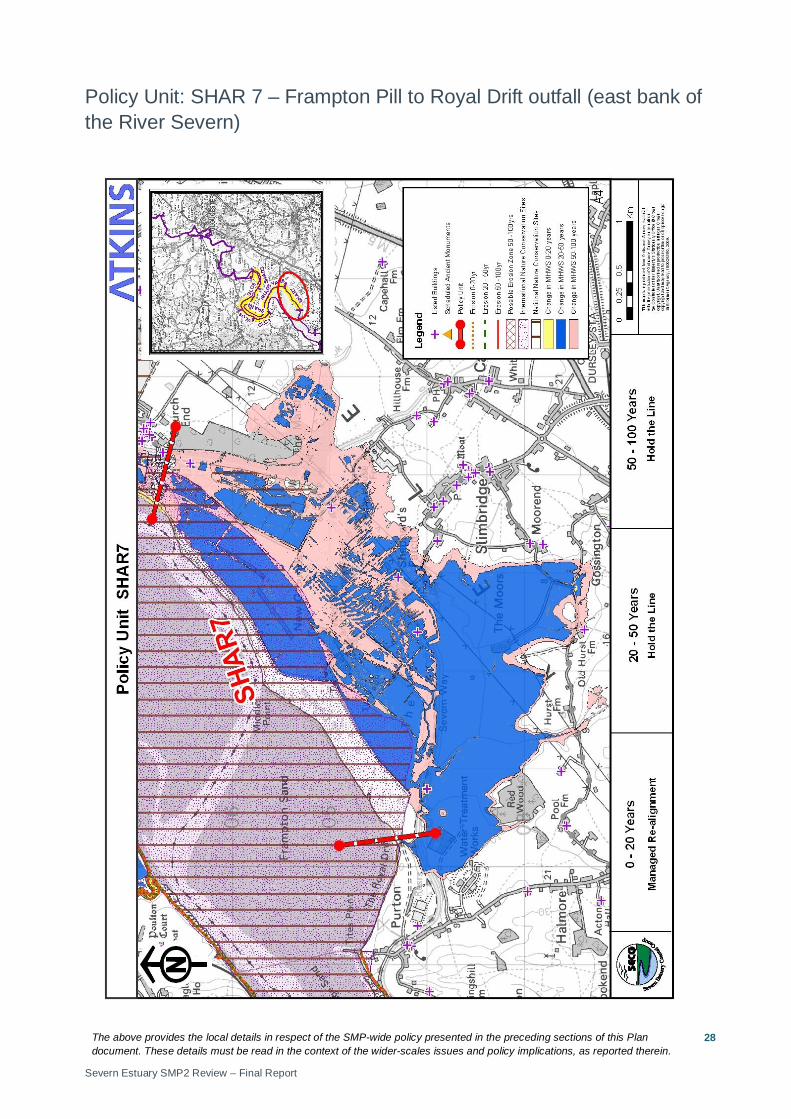
This Theme area contains the Policy Units SHAR 1, SHAR 2, SHAR 3, SHAR 4, SHAR 5, SHAR 6, SHAR 7 and SHAR 8.
It starts at the drain from Long Brook and ends at the south of Sharpness Docks.
The Key Policy Drivers in this area are:
• International nature conservation sites – Severn Estuary SAC, SPA and Ramsar sites;
• Critical infrastructure – railway line, electricity transmission network, sewage treatment works, Sharpness docks.

The above provides the local details in respect of the SMP-wide policy presented in the preceding sections of this Plan document. These details must be read in the context of the wider-scales issues and policy implications, as reported therein.
Severn Estuary SMP2 Review – Final Report
2
The above provides the local details in respect of the SMP-wide policy presented in the preceding sections of this Plan document. These details must be read in the context of the wider-scales issues and policy implications, as reported therein.
Severn Estuary SMP2 Review – Final Report
3
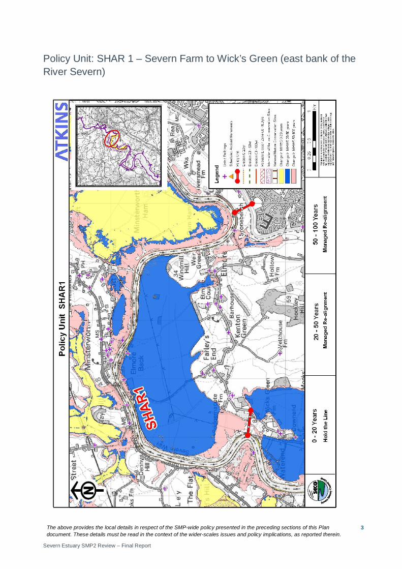
Policy Unit: SHAR 1 – Severn Farm to Wick’s Green (east bank of the River Severn)
The above provides the local details in respect of the SMP-wide policy presented in the preceding sections of this Plan document. These details must be read in the context of the wider-scales issues and policy implications, as reported therein.
Severn Estuary SMP2 Review – Final Report
4
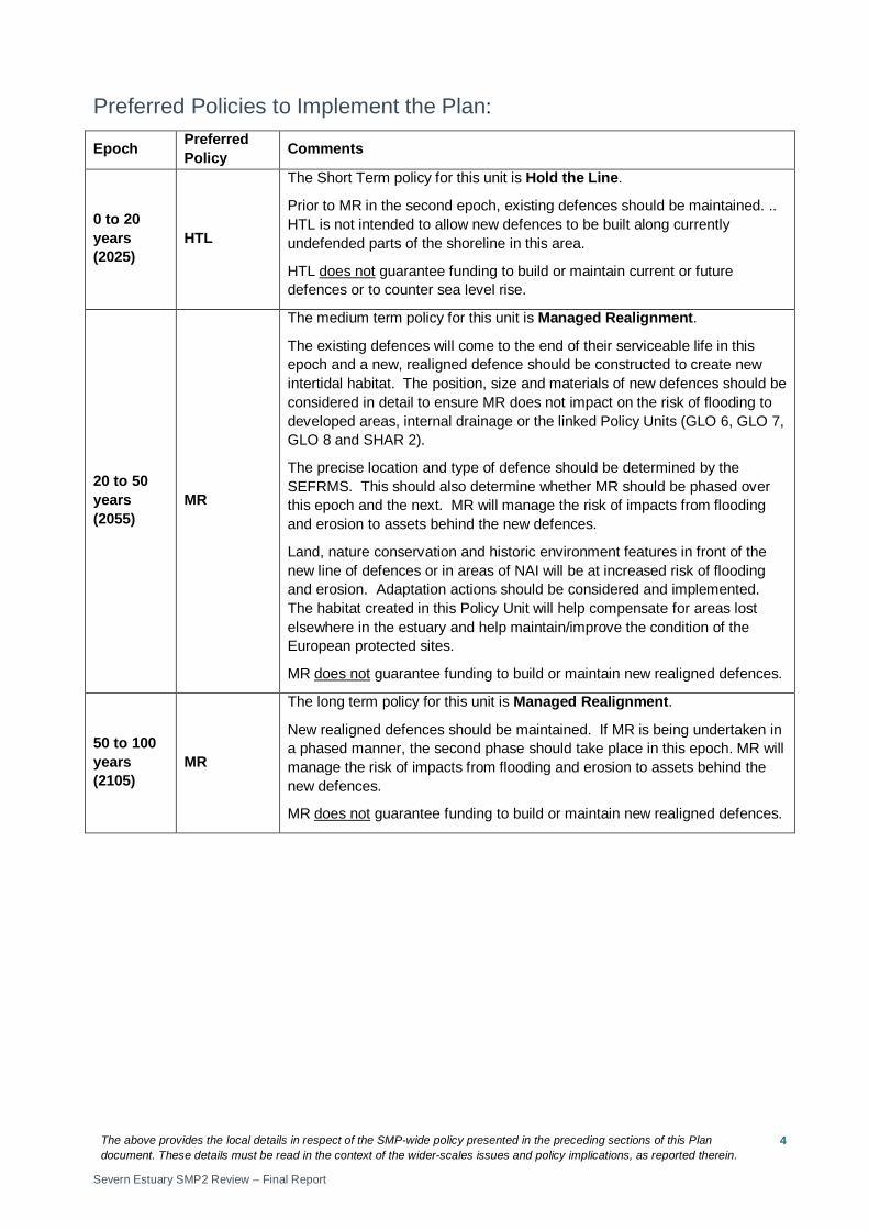
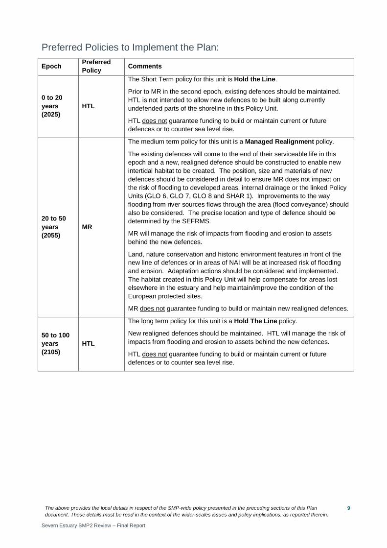
Preferred Policies to Implement the Plan:
Epoch Preferred Policy Comments
0 to 20 years (2025)
HTL
The Short Term policy for this unit is Hold the Line.
Prior to MR in the second epoch, existing defences should be maintained. .. HTL is not intended to allow new defences to be built along currently undefended parts of the shoreline in this area.
HTL does not guarantee funding to build or maintain current or future defences or to counter sea level rise.
20 to 50 years (2055)
MR
The medium term policy for this unit is Managed Realignment.
The existing defences will come to the end of their serviceable life in this epoch and a new, realigned defence should be constructed to create new intertidal habitat. The position, size and materials of new defences should be considered in detail to ensure MR does not impact on the risk of flooding to developed areas, internal drainage or the linked Policy Units (GLO 6, GLO 7, GLO 8 and SHAR 2).
The precise location and type of defence should be determined by the SEFRMS. This should also determine whether MR should be phased over this epoch and the next. MR will manage the risk of impacts from flooding and erosion to assets behind the new defences.
Land, nature conservation and historic environment features in front of the new line of defences or in areas of NAI will be at increased risk of flooding and erosion. Adaptation actions should be considered and implemented. The habitat created in this Policy Unit will help compensate for areas lost elsewhere in the estuary and help maintain/improve the condition of the European protected sites.
MR does not guarantee funding to build or maintain new realigned defences.
50 to 100 years (2105)
MR
The long term policy for this unit is Managed Realignment.
New realigned defences should be maintained. If MR is being undertaken in a phased manner, the second phase should take place in this epoch. MR will manage the risk of impacts from flooding and erosion to assets behind the new defences.
MR does not guarantee funding to build or maintain new realigned defences.

The above provides the local details in respect of the SMP-wide policy presented in the preceding sections of this Plan document. These details must be read in the context of the wider-scales issues and policy implications, as reported therein.
Severn Estuary SMP2 Review – Final Report
5
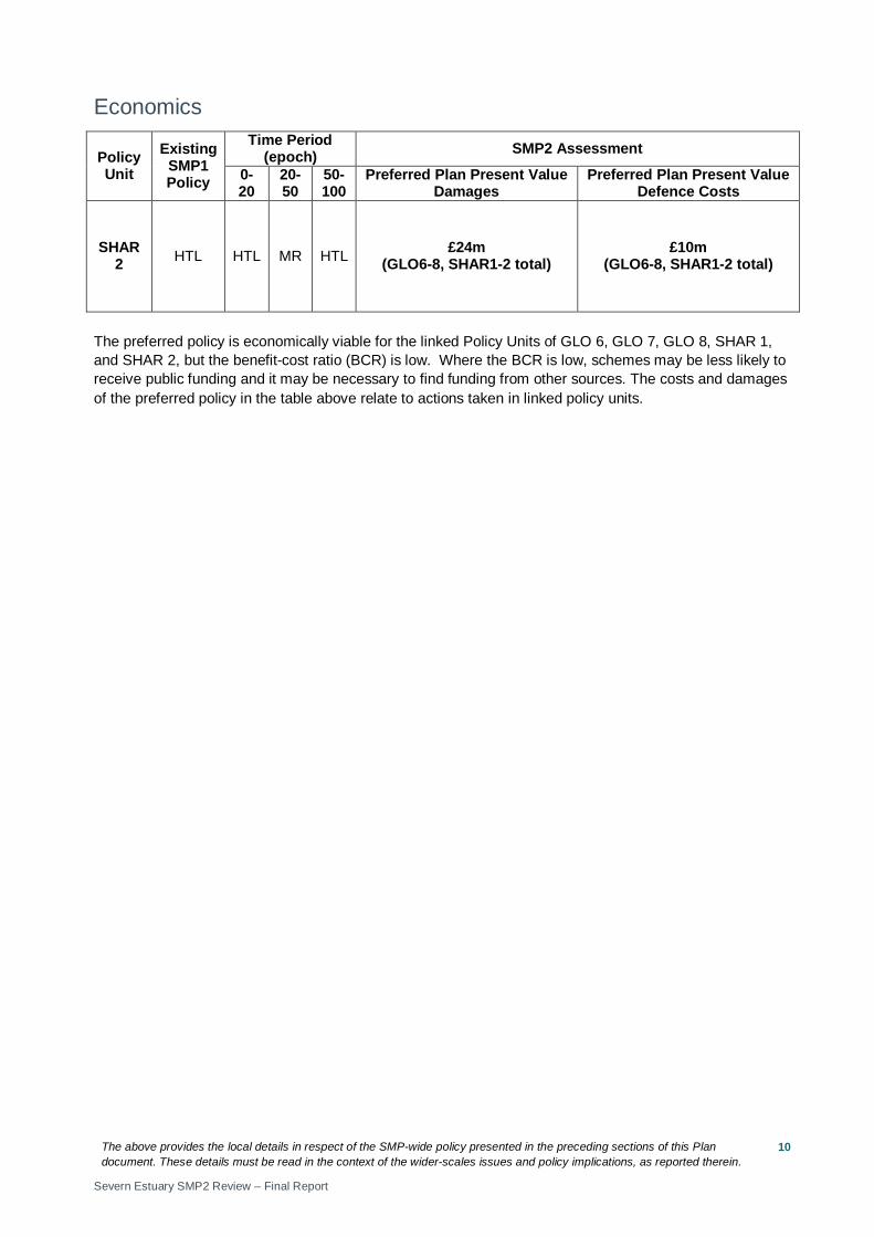
Economics
Policy Unit
Existing SMP1 Policy
Time Period (epoch) SMP2 Assessment
0-20
20-50
50-100
Preferred Plan Present Value Damages
Preferred Plan Present Value Defence Costs
SHAR 1 HTL HTL MR MR £24m
(GLO6-8, SHAR1-2 total) £10m
(GLO6-8, SHAR1-2 total)
The preferred policy is economically viable for the linked Policy Units of GLO 6, GLO 7, GLO 8, SHAR 1, and SHAR 2, but the benefit-cost ratio (BCR) is low. Where the BCR is low, schemes may be less likely to receive public funding and it may be necessary to find funding from other sources. The costs and damages of the preferred policy in the table above relate to actions taken in linked policy units.
The above provides the local details in respect of the SMP-wide policy presented in the preceding sections of this Plan document. These details must be read in the context of the wider-scales issues and policy implications, as reported therein.
Severn Estuary SMP2 Review – Final Report
6
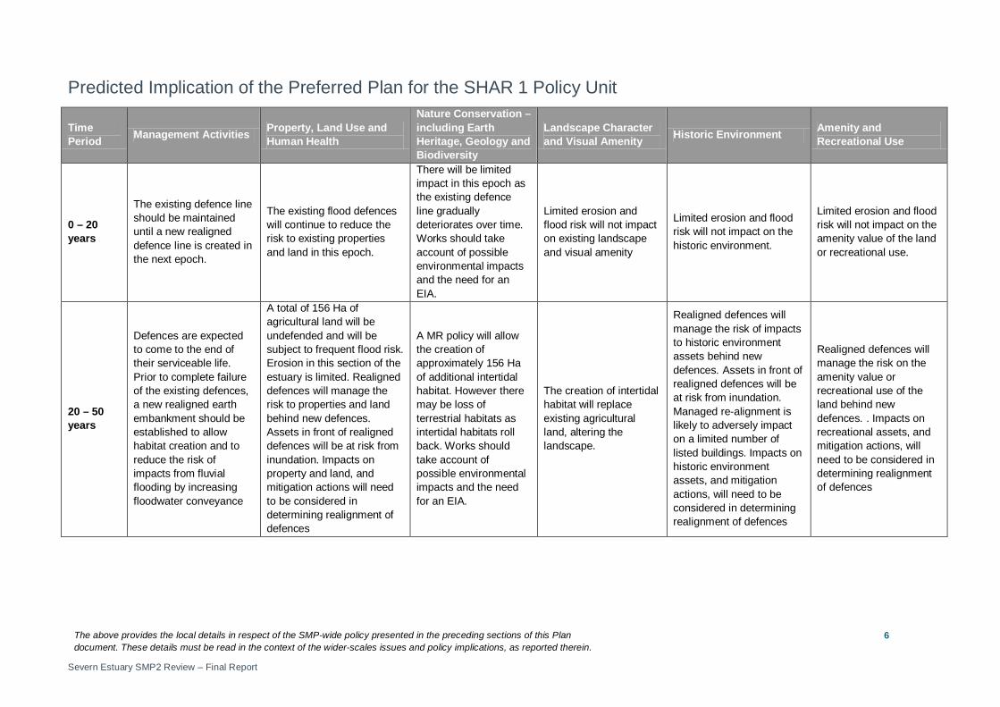
Predicted Implication of the Preferred Plan for the SHAR 1 Policy Unit
Time Period Management Activities Property, Land Use and
Human Health
Nature Conservation – including Earth Heritage, Geology and Biodiversity
Landscape Character and Visual Amenity Historic Environment Amenity and
Recreational Use
0 – 20 years
The existing defence line should be maintained until a new realigned defence line is created in the next epoch.
The existing flood defences will continue to reduce the risk to existing properties and land in this epoch.
There will be limited impact in this epoch as the existing defence line gradually deteriorates over time. Works should take account of possible environmental impacts and the need for an EIA.
Limited erosion and flood risk will not impact on existing landscape and visual amenity
Limited erosion and flood risk will not impact on the historic environment.
Limited erosion and flood risk will not impact on the amenity value of the land or recreational use.
20 – 50 years
Defences are expected to come to the end of their serviceable life. Prior to complete failure of the existing defences, a new realigned earth embankment should be established to allow habitat creation and to reduce the risk of impacts from fluvial flooding by increasing floodwater conveyance
A total of 156 Ha of agricultural land will be undefended and will be subject to frequent flood risk. Erosion in this section of the estuary is limited. Realigned defences will manage the risk to properties and land behind new defences. Assets in front of realigned defences will be at risk from inundation. Impacts on property and land, and mitigation actions will need to be considered in determining realignment of defences
A MR policy will allow the creation of approximately 156 Ha of additional intertidal habitat. However there may be loss of terrestrial habitats as intertidal habitats roll back. Works should take account of possible environmental impacts and the need for an EIA.
The creation of intertidal habitat will replace existing agricultural land, altering the landscape.
Realigned defences will manage the risk of impacts to historic environment assets behind new defences. Assets in front of realigned defences will be at risk from inundation. Managed re-alignment is likely to adversely impact on a limited number of listed buildings. Impacts on historic environment assets, and mitigation actions, will need to be considered in determining realignment of defences
Realigned defences will manage the risk on the amenity value or recreational use of the land behind new defences. . Impacts on recreational assets, and mitigation actions, will need to be considered in determining realignment of defences
The above provides the local details in respect of the SMP-wide policy presented in the preceding sections of this Plan document. These details must be read in the context of the wider-scales issues and policy implications, as reported therein.
Severn Estuary SMP2 Review – Final Report
7
Time Period Management Activities Property, Land Use and
Human Health
Nature Conservation – including Earth Heritage, Geology and Biodiversity
Landscape Character and Visual Amenity Historic Environment Amenity and
Recreational Use
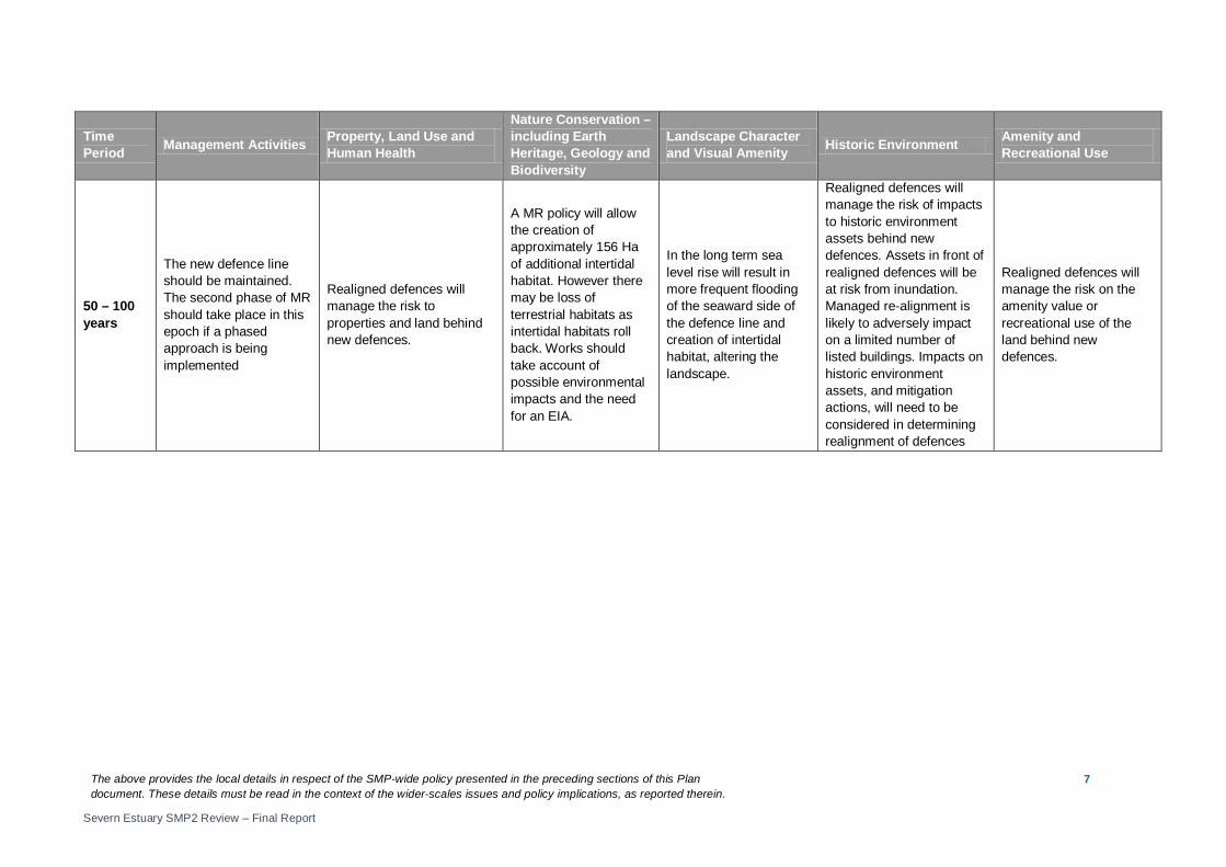
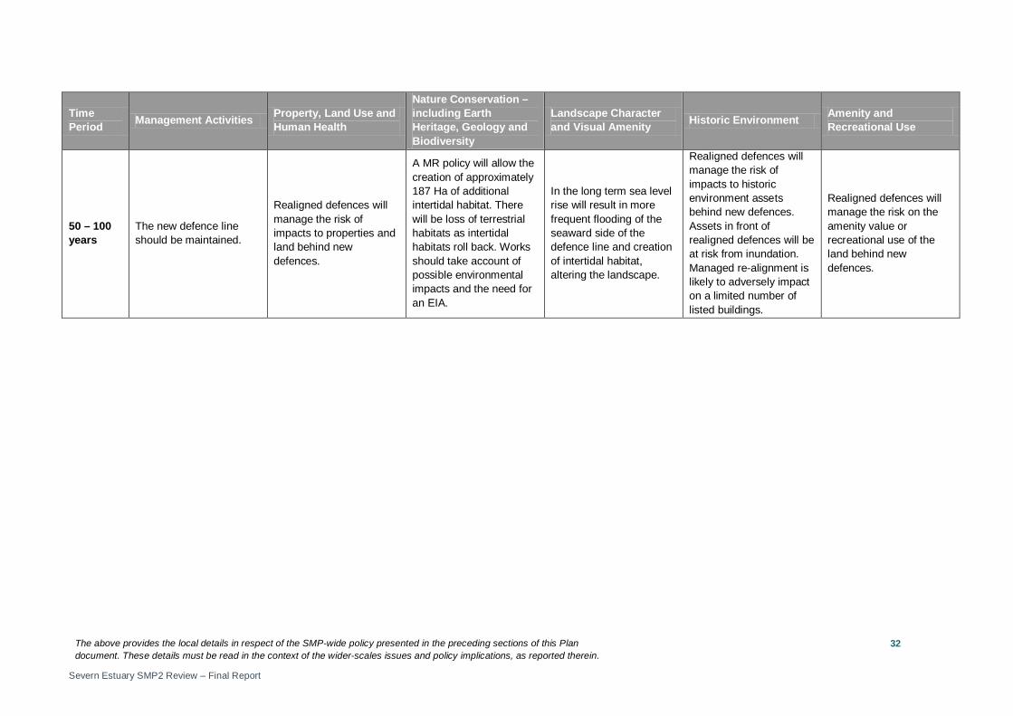
50 – 100 years
The new defence line should be maintained. The second phase of MR should take place in this epoch if a phased approach is being implemented
Realigned defences will manage the risk to properties and land behind new defences.
A MR policy will allow the creation of approximately 156 Ha of additional intertidal habitat. However there may be loss of terrestrial habitats as intertidal habitats roll back. Works should take account of possible environmental impacts and the need for an EIA.
In the long term sea level rise will result in more frequent flooding of the seaward side of the defence line and creation of intertidal habitat, altering the landscape.
Realigned defences will manage the risk of impacts to historic environment assets behind new defences. Assets in front of realigned defences will be at risk from inundation. Managed re-alignment is likely to adversely impact on a limited number of listed buildings. Impacts on historic environment assets, and mitigation actions, will need to be considered in determining realignment of defences
Realigned defences will manage the risk on the amenity value or recreational use of the land behind new defences.
The above provides the local details in respect of the SMP-wide policy presented in the preceding sections of this Plan document. These details must be read in the context of the wider-scales issues and policy implications, as reported therein.
Severn Estuary SMP2 Review – Final Report
8
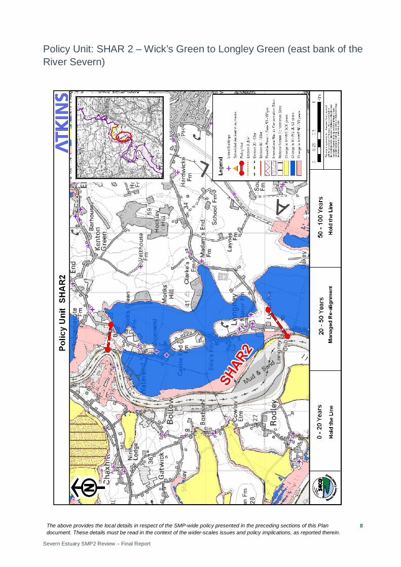
Policy Unit: SHAR 2 – Wick’s Green to Longley Green (east bank of the River Severn)
The above provides the local details in respect of the SMP-wide policy presented in the preceding sections of this Plan document. These details must be read in the context of the wider-scales issues and policy implications, as reported therein.
Severn Estuary SMP2 Review – Final Report
9
Preferred Policies to Implement the Plan:
Epoch Preferred Policy Comments
0 to 20 years (2025)
HTL
The Short Term policy for this unit is Hold the Line.
Prior to MR in the second epoch, existing defences should be maintained. HTL is not intended to allow new defences to be built along currently undefended parts of the shoreline in this Policy Unit.
HTL does not guarantee funding to build or maintain current or future defences or to counter sea level rise.
20 to 50 years (2055)
MR
The medium term policy for this unit is a Managed Realignment policy.
The existing defences will come to the end of their serviceable life in this epoch and a new, realigned defence should be constructed to enable new intertidal habitat to be created. The position, size and materials of new defences should be considered in detail to ensure MR does not impact on the risk of flooding to developed areas, internal drainage or the linked Policy Units (GLO 6, GLO 7, GLO 8 and SHAR 1). Improvements to the way flooding from river sources flows through the area (flood conveyance) should also be considered. The precise location and type of defence should be determined by the SEFRMS.
MR will manage the risk of impacts from flooding and erosion to assets behind the new defences.
Land, nature conservation and historic environment features in front of the new line of defences or in areas of NAI will be at increased risk of flooding and erosion. Adaptation actions should be considered and implemented. The habitat created in this Policy Unit will help compensate for areas lost elsewhere in the estuary and help maintain/improve the condition of the European protected sites.
MR does not guarantee funding to build or maintain new realigned defences.
50 to 100 years (2105)
HTL
The long term policy for this unit is a Hold The Line policy.
New realigned defences should be maintained. HTL will manage the risk of impacts from flooding and erosion to assets behind the new defences.
HTL does not guarantee funding to build or maintain current or future defences or to counter sea level rise.
The above provides the local details in respect of the SMP-wide policy presented in the preceding sections of this Plan document. These details must be read in the context of the wider-scales issues and policy implications, as reported therein.
Severn Estuary SMP2 Review – Final Report
10
Economics
Policy Unit
Existing SMP1 Policy
Time Period (epoch) SMP2 Assessment
0-20
20-50
50-100
Preferred Plan Present Value Damages
Preferred Plan Present Value Defence Costs
SHAR 2 HTL HTL MR HTL £24m
(GLO6-8, SHAR1-2 total) £10m
(GLO6-8, SHAR1-2 total)
The preferred policy is economically viable for the linked Policy Units of GLO 6, GLO 7, GLO 8, SHAR 1, and SHAR 2, but the benefit-cost ratio (BCR) is low. Where the BCR is low, schemes may be less likely to receive public funding and it may be necessary to find funding from other sources. The costs and damages of the preferred policy in the table above relate to actions taken in linked policy units.
The above provides the local details in respect of the SMP-wide policy presented in the preceding sections of this Plan document. These details must be read in the context of the wider-scales issues and policy implications, as reported therein.
Severn Estuary SMP2 Review – Final Report
11
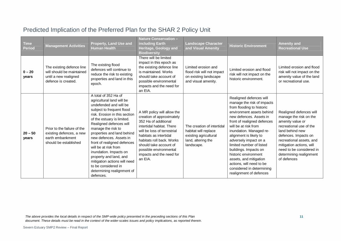
Predicted Implication of the Preferred Plan for the SHAR 2 Policy Unit
Time Period Management Activities Property, Land Use and
Human Health
Nature Conservation – including Earth Heritage, Geology and Biodiversity
Landscape Character and Visual Amenity Historic Environment Amenity and
Recreational Use
0 – 20 years
The existing defence line will should be maintained until a new realigned defence is created.
The existing flood defences will continue to reduce the risk to existing properties and land in this epoch.
There will be limited impact in this epoch as the existing defence line is maintained. Works should take account of possible environmental impacts and the need for an EIA.
Limited erosion and flood risk will not impact on existing landscape and visual amenity.
Limited erosion and flood risk will not impact on the historic environment.
Limited erosion and flood risk will not impact on the amenity value of the land or recreational use.
20 – 50 years
Prior to the failure of the existing defences, a new earth embankment should be established
A total of 352 Ha of agricultural land will be undefended and will be subject to frequent flood risk. Erosion in this section of the estuary is limited. Realigned defences will manage the risk to properties and land behind new defences. Assets in front of realigned defences will be at risk from inundation. Impacts on property and land, and mitigation actions will need to be considered in determining realignment of defences.
A MR policy will allow the creation of approximately 352 Ha of additional intertidal habitat. There will be loss of terrestrial habitats as intertidal habitats roll back. Works should take account of possible environmental impacts and the need for an EIA.
The creation of intertidal habitat will replace existing agricultural land, altering the landscape.
Realigned defences will manage the risk of impacts from flooding to historic environment assets behind new defences. Assets in front of realigned defences will be at risk from inundation. Managed re-alignment is likely to adversely impact on a limited number of listed buildings. Impacts on historic environment assets, and mitigation actions, will need to be considered in determining realignment of defences
Realigned defences will manage the risk on the amenity value or recreational use of the land behind new defences. Impacts on recreational assets, and mitigation actions, will need to be considered in determining realignment of defences
The above provides the local details in respect of the SMP-wide policy presented in the preceding sections of this Plan document. These details must be read in the context of the wider-scales issues and policy implications, as reported therein.
Severn Estuary SMP2 Review – Final Report
12
Time Period Management Activities Property, Land Use and
Human Health
Nature Conservation – including Earth Heritage, Geology and Biodiversity
Landscape Character and Visual Amenity Historic Environment Amenity and
Recreational Use
50 – 100 years
The new defence line should be maintained.
Realigned defences will manage the risk to properties and land behind new defences.
A MR policy will allow the creation of approximately 352 Ha of additional intertidal habitat. There will be loss of terrestrial habitats as intertidal habitats roll back. Works should take account of possible environmental impacts and the need for an EIA.
In the long term sea level rise will result in more frequent flooding of the seaward side of the defence line and creation of intertidal habitat, altering the landscape.
Realigned defences will manage the risk of impacts from flooding to historic environment assets behind new defences. Assets in front of realigned defences will be at risk from inundation. Managed re-alignment is likely to adversely impact on a limited number of listed buildings. Impacts on historic environment assets, and mitigation actions, will need to be considered in determining realignment of defences
Realigned defences will manage the risk on the amenity value or recreational use of the land behind new defences.
The above provides the local details in respect of the SMP-wide policy presented in the preceding sections of this Plan document. These details must be read in the context of the wider-scales issues and policy implications, as reported therein.
Severn Estuary SMP2 Review – Final Report
13
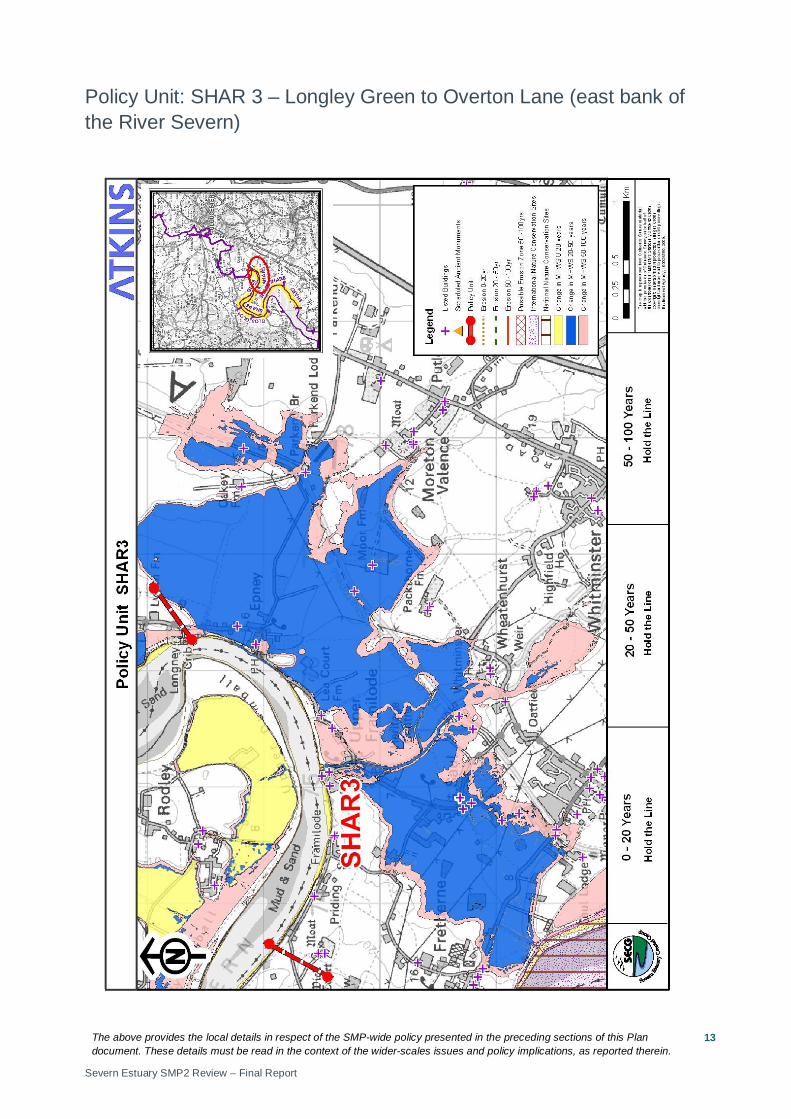
Policy Unit: SHAR 3 – Longley Green to Overton Lane (east bank of the River Severn)
The above provides the local details in respect of the SMP-wide policy presented in the preceding sections of this Plan document. These details must be read in the context of the wider-scales issues and policy implications, as reported therein.
Severn Estuary SMP2 Review – Final Report
14
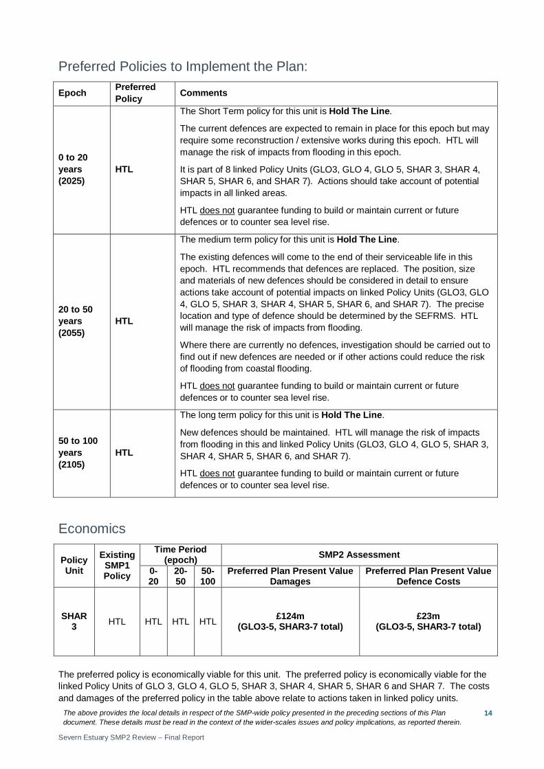
Preferred Policies to Implement the Plan:
Epoch Preferred Policy Comments
0 to 20 years (2025)
HTL
The Short Term policy for this unit is Hold The Line.
The current defences are expected to remain in place for this epoch but may require some reconstruction / extensive works during this epoch. HTL will manage the risk of impacts from flooding in this epoch.
It is part of 8 linked Policy Units (GLO3, GLO 4, GLO 5, SHAR 3, SHAR 4, SHAR 5, SHAR 6, and SHAR 7). Actions should take account of potential impacts in all linked areas.
HTL does not guarantee funding to build or maintain current or future defences or to counter sea level rise.
20 to 50 years (2055)
HTL
The medium term policy for this unit is Hold The Line.
The existing defences will come to the end of their serviceable life in this epoch. HTL recommends that defences are replaced. The position, size and materials of new defences should be considered in detail to ensure actions take account of potential impacts on linked Policy Units (GLO3, GLO 4, GLO 5, SHAR 3, SHAR 4, SHAR 5, SHAR 6, and SHAR 7). The precise location and type of defence should be determined by the SEFRMS. HTL will manage the risk of impacts from flooding.
Where there are currently no defences, investigation should be carried out to find out if new defences are needed or if other actions could reduce the risk of flooding from coastal flooding.
HTL does not guarantee funding to build or maintain current or future defences or to counter sea level rise.
50 to 100 years (2105)
HTL
The long term policy for this unit is Hold The Line.
New defences should be maintained. HTL will manage the risk of impacts from flooding in this and linked Policy Units (GLO3, GLO 4, GLO 5, SHAR 3, SHAR 4, SHAR 5, SHAR 6, and SHAR 7).
HTL does not guarantee funding to build or maintain current or future defences or to counter sea level rise.
Economics
Policy Unit
Existing SMP1 Policy
Time Period (epoch) SMP2 Assessment
0-20
20-50
50-100
Preferred Plan Present Value Damages
Preferred Plan Present Value Defence Costs
SHAR 3 HTL HTL HTL HTL £124m
(GLO3-5, SHAR3-7 total) £23m
(GLO3-5, SHAR3-7 total)
The preferred policy is economically viable for this unit. The preferred policy is economically viable for the linked Policy Units of GLO 3, GLO 4, GLO 5, SHAR 3, SHAR 4, SHAR 5, SHAR 6 and SHAR 7. The costs and damages of the preferred policy in the table above relate to actions taken in linked policy units.
The above provides the local details in respect of the SMP-wide policy presented in the preceding sections of this Plan document. These details must be read in the context of the wider-scales issues and policy implications, as reported therein.
Severn Estuary SMP2 Review – Final Report
15
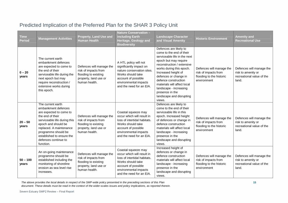
Predicted Implication of the Preferred Plan for the SHAR 3 Policy Unit
Time Period Management Activities Property, Land Use and
Human Health
Nature Conservation – including Earth Heritage, Geology and Biodiversity
Landscape Character and Visual Amenity Historic Environment Amenity and
Recreational Use
0 – 20 years
The current earth embankment defences are expected to come to the end of their serviceable life during the next epoch but may require reconstruction / extensive works during this epoch.
Defences will manage the risk of impacts from flooding to existing property, land use or human health.
A HTL policy will not significantly impact on nature conservation sites. Works should take account of possible environmental impacts and the need for an EIA.
Defences are likely to come to the end of their serviceable life in the next epoch but may require reconstruction / extensive works during this epoch. Increased height of defences or change in defence construction materials will affect local landscape - increasing presence in the landscape and disrupting views.
Defences will manage the risk of impacts from flooding to the historic environment
Defences will manage the risk to amenity or recreational value of the land.
20 – 50 years
The current earth embankment defences are expected to come to the end of their serviceable life during this epoch and should be replaced. A maintenance programme should be established to ensure the defences continue to function.
Defences will manage the risk of impacts from flooding to existing property, land use or human health.
Coastal squeeze may occur which will result in loss of intertidal habitats. Works should take account of possible environmental impacts and the need for an EIA.
Defences are likely to come to the end of their serviceable life in this epoch. Increased height of defences or change in defence construction materials will affect local landscape - increasing presence in the landscape and disrupting views.
Defences will manage the risk of impacts from flooding to the historic environment
Defences will manage the risk to amenity or recreational value of the land.
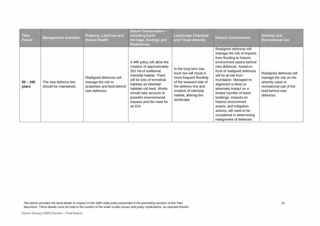
50 – 100 years
An on-going maintenance programme should be established including the monitoring of shoreline erosion as sea level rise increases.
Defences will manage the risk of impacts from flooding to existing property, land use or human health.
Coastal squeeze may occur which will result in loss of intertidal habitats. Works should take account of possible environmental impacts and the need for an EIA.
Increased height of defences or change in defence construction materials will affect local landscape - increasing presence in the landscape and disrupting views.
Defences will manage the risk of impacts from flooding to the historic environment
Defences will manage the risk to amenity or recreational value of the land.
The above provides the local details in respect of the SMP-wide policy presented in the preceding sections of this Plan document. These details must be read in the context of the wider-scales issues and policy implications, as reported therein.
Severn Estuary SMP2 Review – Final Report
16
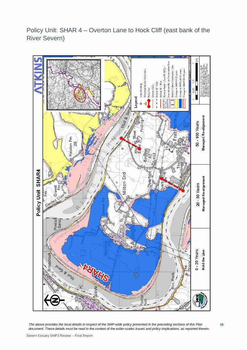
Policy Unit: SHAR 4 – Overton Lane to Hock Cliff (east bank of the River Severn)
The above provides the local details in respect of the SMP-wide policy presented in the preceding sections of this Plan document. These details must be read in the context of the wider-scales issues and policy implications, as reported therein.
Severn Estuary SMP2 Review – Final Report
17
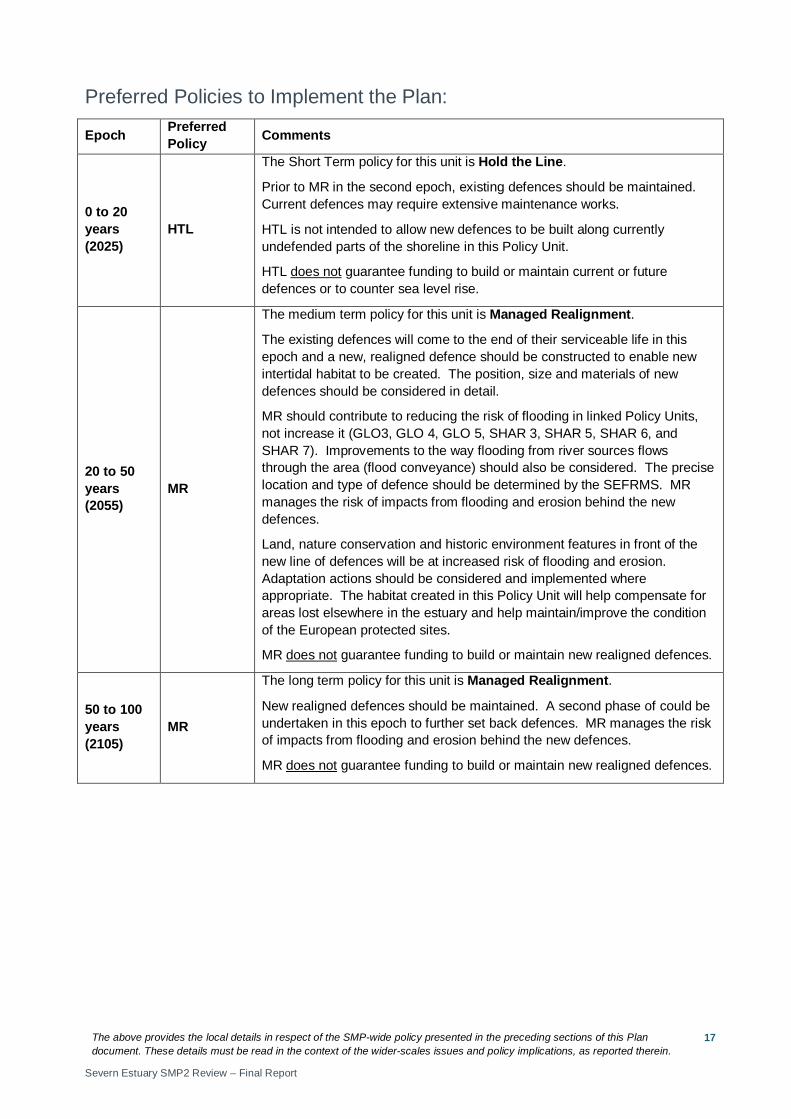
Preferred Policies to Implement the Plan:
Epoch Preferred Policy Comments
0 to 20 years (2025)
HTL
The Short Term policy for this unit is Hold the Line.
Prior to MR in the second epoch, existing defences should be maintained. Current defences may require extensive maintenance works.
HTL is not intended to allow new defences to be built along currently undefended parts of the shoreline in this Policy Unit.
HTL does not guarantee funding to build or maintain current or future defences or to counter sea level rise.
20 to 50 years (2055)
MR
The medium term policy for this unit is Managed Realignment.
The existing defences will come to the end of their serviceable life in this epoch and a new, realigned defence should be constructed to enable new intertidal habitat to be created. The position, size and materials of new defences should be considered in detail.
MR should contribute to reducing the risk of flooding in linked Policy Units, not increase it (GLO3, GLO 4, GLO 5, SHAR 3, SHAR 5, SHAR 6, and SHAR 7). Improvements to the way flooding from river sources flows through the area (flood conveyance) should also be considered. The precise location and type of defence should be determined by the SEFRMS. MR manages the risk of impacts from flooding and erosion behind the new defences.
Land, nature conservation and historic environment features in front of the new line of defences will be at increased risk of flooding and erosion. Adaptation actions should be considered and implemented where appropriate. The habitat created in this Policy Unit will help compensate for areas lost elsewhere in the estuary and help maintain/improve the condition of the European protected sites.
MR does not guarantee funding to build or maintain new realigned defences.
50 to 100 years (2105)
MR
The long term policy for this unit is Managed Realignment.
New realigned defences should be maintained. A second phase of could be undertaken in this epoch to further set back defences. MR manages the risk of impacts from flooding and erosion behind the new defences.
MR does not guarantee funding to build or maintain new realigned defences.
The above provides the local details in respect of the SMP-wide policy presented in the preceding sections of this Plan document. These details must be read in the context of the wider-scales issues and policy implications, as reported therein.
Severn Estuary SMP2 Review – Final Report
18
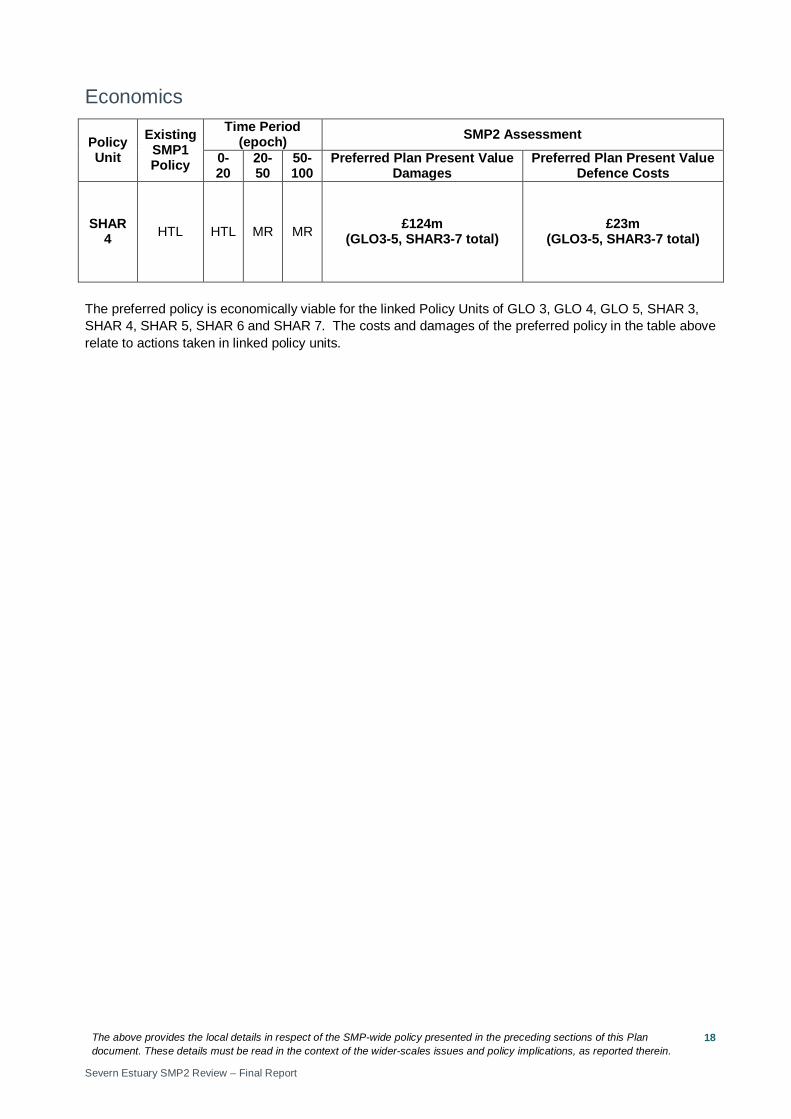
Economics
Policy Unit
Existing SMP1 Policy
Time Period (epoch) SMP2 Assessment
0-20
20-50
50-100
Preferred Plan Present Value Damages
Preferred Plan Present Value Defence Costs
SHAR 4 HTL HTL MR MR £124m
(GLO3-5, SHAR3-7 total) £23m
(GLO3-5, SHAR3-7 total)
The preferred policy is economically viable for the linked Policy Units of GLO 3, GLO 4, GLO 5, SHAR 3, SHAR 4, SHAR 5, SHAR 6 and SHAR 7. The costs and damages of the preferred policy in the table above relate to actions taken in linked policy units.
The above provides the local details in respect of the SMP-wide policy presented in the preceding sections of this Plan document. These details must be read in the context of the wider-scales issues and policy implications, as reported therein.
Severn Estuary SMP2 Review – Final Report
19
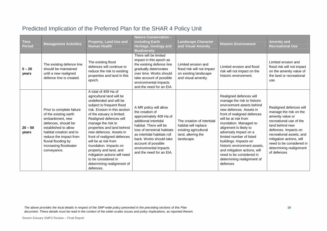
Predicted Implication of the Preferred Plan for the SHAR 4 Policy Unit
Time Period Management Activities Property, Land Use and
Human Health
Nature Conservation – including Earth Heritage, Geology and Biodiversity
Landscape Character and Visual Amenity Historic Environment Amenity and
Recreational Use
0 – 20 years
The existing defence line should be maintained until a new realigned defence line is created.
The existing flood defences will continue to reduce the risk to existing properties and land in this epoch.
There will be limited impact in this epoch as the existing defence line gradually deteriorates over time. Works should take account of possible environmental impacts and the need for an EIA.
Limited erosion and flood risk will not impact on existing landscape and visual amenity.
Limited erosion and flood risk will not impact on the historic environment.
Limited erosion and flood risk will not impact on the amenity value of the land or recreational use.
20 – 50 years
Prior to complete failure of the existing earth embankment, new defences, should be established to allow habitat creation and to reduce the impact from fluvial flooding by increasing floodwater conveyance.
A total of 409 Ha of agricultural land will be undefended and will be subject to frequent flood risk. Erosion in this section of the estuary is limited. Realigned defences will manage the risk to properties and land behind new defences. Assets in front of realigned defences will be at risk from inundation. Impacts on property and land, and mitigation actions will need to be considered in determining realignment of defences.
A MR policy will allow the creation of approximately 409 Ha of additional intertidal habitat. There will be loss of terrestrial habitats as intertidal habitats roll back. Works should take account of possible environmental impacts and the need for an EIA.
The creation of intertidal habitat will replace existing agricultural land, altering the landscape.
Realigned defences will manage the risk to historic environment assets behind new defences. Assets in front of realigned defences will be at risk from inundation. Managed re-alignment is likely to adversely impact on a limited number of listed buildings. Impacts on historic environment assets, and mitigation actions, will need to be considered in determining realignment of defences
Realigned defences will manage the risk on the amenity value or recreational use of the land behind new defences. Impacts on recreational assets, and mitigation actions, will need to be considered in determining realignment of defences
The above provides the local details in respect of the SMP-wide policy presented in the preceding sections of this Plan document. These details must be read in the context of the wider-scales issues and policy implications, as reported therein.
Severn Estuary SMP2 Review – Final Report
20
Time Period Management Activities Property, Land Use and
Human Health
Nature Conservation – including Earth Heritage, Geology and Biodiversity
Landscape Character and Visual Amenity Historic Environment Amenity and
Recreational Use
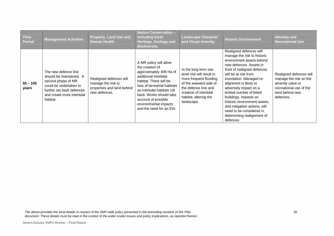
50 – 100 years
The new defence line should be maintained. A second phase of MR could be undertaken to further set back defences and create more intertidal habitat.
Realigned defences will manage the risk to properties and land behind new defences.
A MR policy will allow the creation of approximately 409 Ha of additional intertidal habitat. There will be loss of terrestrial habitats as intertidal habitats roll back. Works should take account of possible environmental impacts and the need for an EIA.
In the long term sea level rise will result in more frequent flooding of the seaward side of the defence line and creation of intertidal habitat, altering the landscape.
Realigned defences will manage the risk to historic environment assets behind new defences. Assets in front of realigned defences will be at risk from inundation. Managed re-alignment is likely to adversely impact on a limited number of listed buildings. Impacts on historic environment assets, and mitigation actions, will need to be considered in determining realignment of defences
Realigned defences will manage the risk on the amenity value or recreational use of the land behind new defences.
The above provides the local details in respect of the SMP-wide policy presented in the preceding sections of this Plan document. These details must be read in the context of the wider-scales issues and policy implications, as reported therein.
Severn Estuary SMP2 Review – Final Report
21
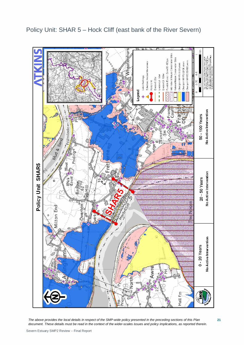
Policy Unit: SHAR 5 – Hock Cliff (east bank of the River Severn)
The above provides the local details in respect of the SMP-wide policy presented in the preceding sections of this Plan document. These details must be read in the context of the wider-scales issues and policy implications, as reported therein.
Severn Estuary SMP2 Review – Final Report
22
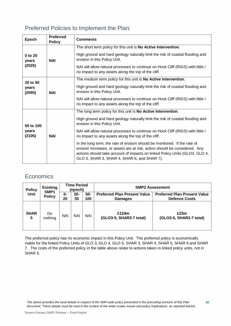
Preferred Policies to Implement the Plan:
Epoch Preferred Policy Comments
0 to 20 years (2025)
NAI
The short term policy for this unit is No Active Intervention.
High ground and hard geology naturally limit the risk of coastal flooding and erosion in this Policy Unit.
NAI will allow natural processes to continue on Hock Cliff (RIGS) with little / no impact to any assets along the top of the cliff.
20 to 50 years (2055)
NAI
The medium term policy for this unit is No Active Intervention.
High ground and hard geology naturally limit the risk of coastal flooding and erosion in this Policy Unit.
NAI will allow natural processes to continue on Hock Cliff (RIGS) with little / no impact to any assets along the top of the cliff.
50 to 100 years (2105)
NAI
The long term policy for this unit is No Active Intervention.
High ground and hard geology naturally limit the risk of coastal flooding and erosion in this Policy Unit.
NAI will allow natural processes to continue on Hock Cliff (RIGS) with little / no impact to any assets along the top of the cliff.
In the long term, the rate of erosion should be monitored. If the rate of erosion increases, or assets are at risk, action should be considered. Any actions should take account of impacts on linked Policy Units (GLO3, GLO 4, GLO 5, SHAR 3, SHAR 4, SHAR 6, and SHAR 7).
Economics
Policy Unit
Existing SMP1 Policy
Time Period (epoch) SMP2 Assessment
0-20
20-50
50-100
Preferred Plan Present Value Damages
Preferred Plan Present Value Defence Costs
SHAR 5
Do nothing NAI NAI NAI £124m
(GLO3-5, SHAR3-7 total) £23m
(GLO3-5, SHAR3-7 total)
The preferred policy has no economic impact in this Policy Unit. The preferred policy is economically viable for the linked Policy Units of GLO 3, GLO 4, GLO 5, SHAR 3, SHAR 4, SHAR 5, SHAR 6 and SHAR 7. The costs of the preferred policy in the table above relate to actions taken in linked policy units, not in SHAR 5.
The above provides the local details in respect of the SMP-wide policy presented in the preceding sections of this Plan document. These details must be read in the context of the wider-scales issues and policy implications, as reported therein.
Severn Estuary SMP2 Review – Final Report
23
Predicted Implication of the Preferred Plan for the SHAR 5 Policy Unit
Time Period Management Activities Property, Land Use and
Human Health
Nature Conservation – including Earth Heritage, Geology and Biodiversity
Landscape Character and Visual Amenity Historic Environment Amenity and
Recreational Use
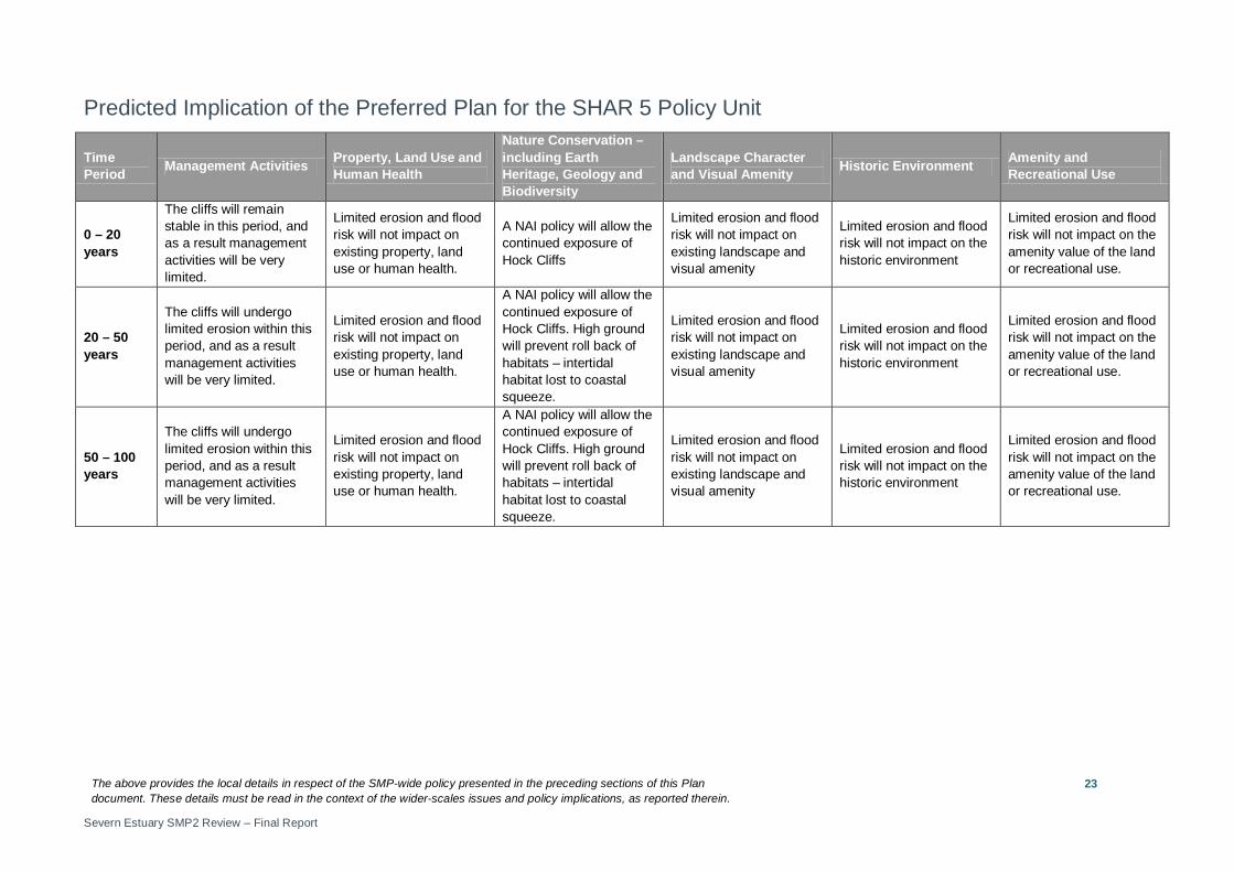
0 – 20 years
The cliffs will remain stable in this period, and as a result management activities will be very limited.
Limited erosion and flood risk will not impact on existing property, land use or human health.
A NAI policy will allow the continued exposure of Hock Cliffs
Limited erosion and flood risk will not impact on existing landscape and visual amenity
Limited erosion and flood risk will not impact on the historic environment
Limited erosion and flood risk will not impact on the amenity value of the land or recreational use.
20 – 50 years
The cliffs will undergo limited erosion within this period, and as a result management activities will be very limited.
Limited erosion and flood risk will not impact on existing property, land use or human health.
A NAI policy will allow the continued exposure of Hock Cliffs. High ground will prevent roll back of habitats – intertidal habitat lost to coastal squeeze.
Limited erosion and flood risk will not impact on existing landscape and visual amenity
Limited erosion and flood risk will not impact on the historic environment
Limited erosion and flood risk will not impact on the amenity value of the land or recreational use.
50 – 100 years
The cliffs will undergo limited erosion within this period, and as a result management activities will be very limited.
Limited erosion and flood risk will not impact on existing property, land use or human health.
A NAI policy will allow the continued exposure of Hock Cliffs. High ground will prevent roll back of habitats – intertidal habitat lost to coastal squeeze.
Limited erosion and flood risk will not impact on existing landscape and visual amenity
Limited erosion and flood risk will not impact on the historic environment
Limited erosion and flood risk will not impact on the amenity value of the land or recreational use.
The above provides the local details in respect of the SMP-wide policy presented in the preceding sections of this Plan document. These details must be read in the context of the wider-scales issues and policy implications, as reported therein.
Severn Estuary SMP2 Review – Final Report
24
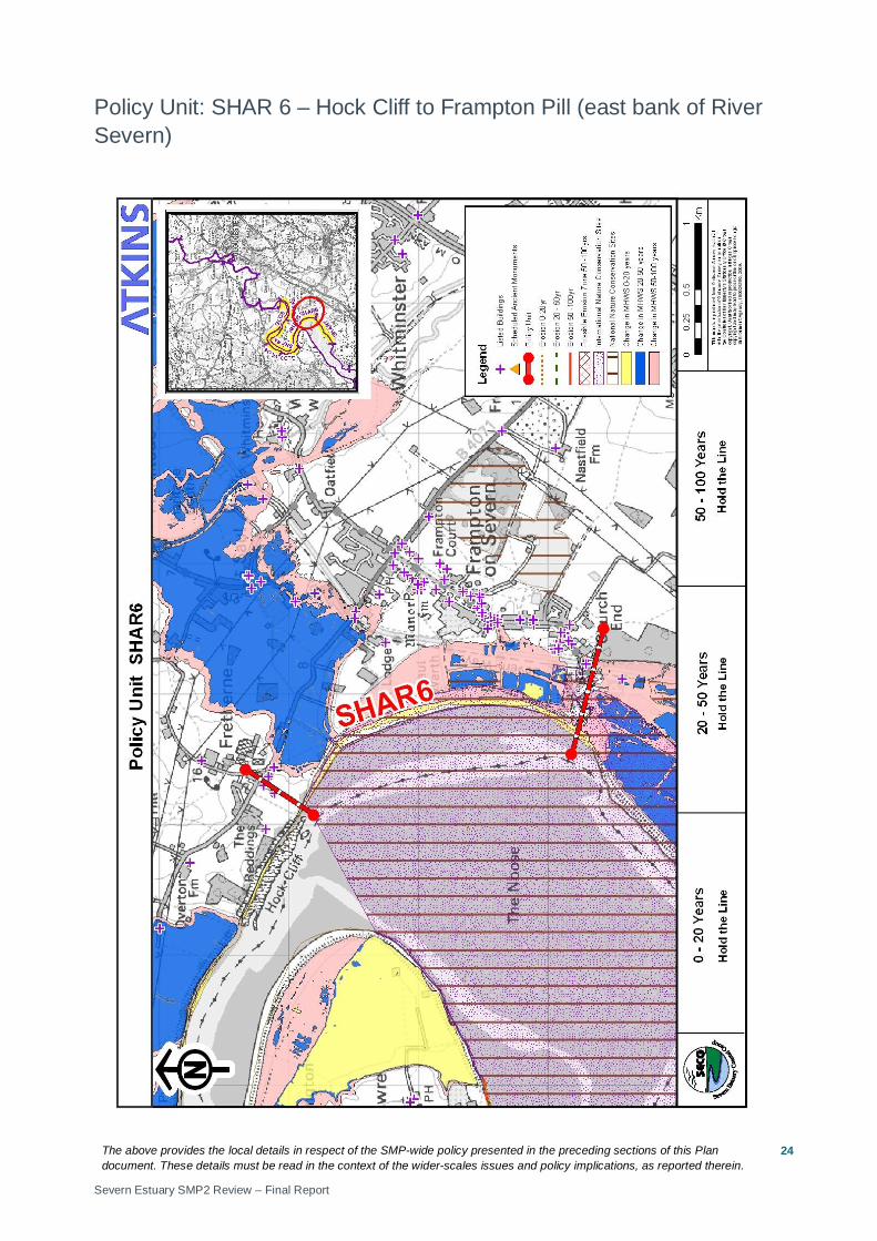
Policy Unit: SHAR 6 – Hock Cliff to Frampton Pill (east bank of River Severn)
The above provides the local details in respect of the SMP-wide policy presented in the preceding sections of this Plan document. These details must be read in the context of the wider-scales issues and policy implications, as reported therein.
Severn Estuary SMP2 Review – Final Report
25
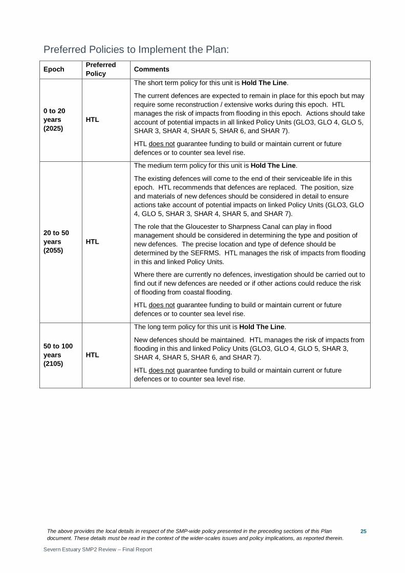
Preferred Policies to Implement the Plan:
Epoch Preferred Policy Comments
0 to 20 years (2025)
HTL
The short term policy for this unit is Hold The Line.
The current defences are expected to remain in place for this epoch but may require some reconstruction / extensive works during this epoch. HTL manages the risk of impacts from flooding in this epoch. Actions should take account of potential impacts in all linked Policy Units (GLO3, GLO 4, GLO 5, SHAR 3, SHAR 4, SHAR 5, SHAR 6, and SHAR 7).
HTL does not guarantee funding to build or maintain current or future defences or to counter sea level rise.
20 to 50 years (2055)
HTL
The medium term policy for this unit is Hold The Line.
The existing defences will come to the end of their serviceable life in this epoch. HTL recommends that defences are replaced. The position, size and materials of new defences should be considered in detail to ensure actions take account of potential impacts on linked Policy Units (GLO3, GLO 4, GLO 5, SHAR 3, SHAR 4, SHAR 5, and SHAR 7).
The role that the Gloucester to Sharpness Canal can play in flood management should be considered in determining the type and position of new defences. The precise location and type of defence should be determined by the SEFRMS. HTL manages the risk of impacts from flooding in this and linked Policy Units.
Where there are currently no defences, investigation should be carried out to find out if new defences are needed or if other actions could reduce the risk of flooding from coastal flooding.
HTL does not guarantee funding to build or maintain current or future defences or to counter sea level rise.
50 to 100 years (2105)
HTL
The long term policy for this unit is Hold The Line.
New defences should be maintained. HTL manages the risk of impacts from flooding in this and linked Policy Units (GLO3, GLO 4, GLO 5, SHAR 3, SHAR 4, SHAR 5, SHAR 6, and SHAR 7).
HTL does not guarantee funding to build or maintain current or future defences or to counter sea level rise.
The above provides the local details in respect of the SMP-wide policy presented in the preceding sections of this Plan document. These details must be read in the context of the wider-scales issues and policy implications, as reported therein.
Severn Estuary SMP2 Review – Final Report
26
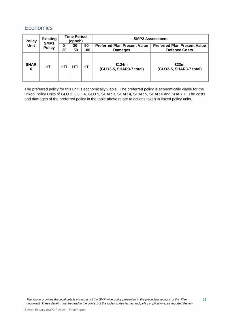
Economics
Policy Unit
Existing SMP1 Policy
Time Period (epoch) SMP2 Assessment
0-20
20-50
50-100
Preferred Plan Present Value Damages
Preferred Plan Present Value Defence Costs
SHAR 6 HTL HTL HTL HTL £124m
(GLO3-5, SHAR3-7 total) £23m
(GLO3-5, SHAR3-7 total)
The preferred policy for this unit is economically viable. The preferred policy is economically viable for the linked Policy Units of GLO 3, GLO 4, GLO 5, SHAR 3, SHAR 4, SHAR 5, SHAR 6 and SHAR 7. The costs and damages of the preferred policy in the table above relate to actions taken in linked policy units.
The above provides the local details in respect of the SMP-wide policy presented in the preceding sections of this Plan document. These details must be read in the context of the wider-scales issues and policy implications, as reported therein.
Severn Estuary SMP2 Review – Final Report
27
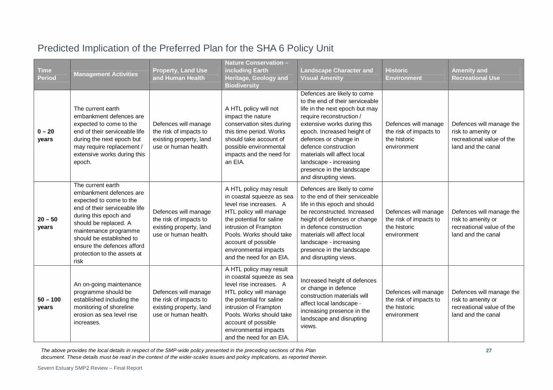
Predicted Implication of the Preferred Plan for the SHA 6 Policy Unit
Time Period Management Activities Property, Land Use
and Human Health
Nature Conservation – including Earth Heritage, Geology and Biodiversity
Landscape Character and Visual Amenity
Historic Environment
Amenity and Recreational Use
0 – 20 years
The current earth embankment defences are expected to come to the end of their serviceable life during the next epoch but may require replacement / extensive works during this epoch.
Defences will manage the risk of impacts to existing property, land use or human health.
A HTL policy will not impact the nature conservation sites during this time period. Works should take account of possible environmental impacts and the need for an EIA.
Defences are likely to come to the end of their serviceable life in the next epoch but may require reconstruction / extensive works during this epoch. Increased height of defences or change in defence construction materials will affect local landscape - increasing presence in the landscape and disrupting views.
Defences will manage the risk of impacts to the historic environment
Defences will manage the risk to amenity or recreational value of the land and the canal
20 – 50 years
The current earth embankment defences are expected to come to the end of their serviceable life during this epoch and should be replaced. A maintenance programme should be established to ensure the defences afford protection to the assets at risk
Defences will manage the risk of impacts to existing property, land use or human health.
A HTL policy may result in coastal squeeze as sea level rise increases. A HTL policy will manage the potential for saline intrusion of Frampton Pools. Works should take account of possible environmental impacts and the need for an EIA.
Defences are likely to come to the end of their serviceable life in this epoch and should be reconstructed. Increased height of defences or change in defence construction materials will affect local landscape - increasing presence in the landscape and disrupting views.
Defences will manage the risk of impacts to the historic environment
Defences will manage the risk to amenity or recreational value of the land and the canal
50 – 100 years
An on-going maintenance programme should be established including the monitoring of shoreline erosion as sea level rise increases.
Defences will manage the risk of impacts to existing property, land use or human health.
A HTL policy may result in coastal squeeze as sea level rise increases. A HTL policy will manage the potential for saline intrusion of Frampton Pools. Works should take account of possible environmental impacts and the need for an EIA.
Increased height of defences or change in defence construction materials will affect local landscape - increasing presence in the landscape and disrupting views.
Defences will manage the risk of impacts to the historic environment
Defences will manage the risk to amenity or recreational value of the land and the canal
The above provides the local details in respect of the SMP-wide policy presented in the preceding sections of this Plan document. These details must be read in the context of the wider-scales issues and policy implications, as reported therein.
Severn Estuary SMP2 Review – Final Report
28
Policy Unit: SHAR 7 – Frampton Pill to Royal Drift outfall (east bank of the River Severn)
The above provides the local details in respect of the SMP-wide policy presented in the preceding sections of this Plan document. These details must be read in the context of the wider-scales issues and policy implications, as reported therein.
Severn Estuary SMP2 Review – Final Report
29
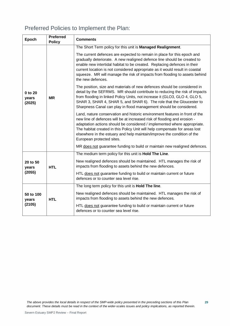
Preferred Policies to Implement the Plan:
Epoch Preferred Policy Comments
0 to 20 years (2025)
MR
The Short Term policy for this unit is Managed Realignment.
The current defences are expected to remain in place for this epoch and gradually deteriorate. A new realigned defence line should be created to enable new intertidal habitat to be created. Replacing defences in their current location is not considered appropriate as it would result in coastal squeeze. MR will manage the risk of impacts from flooding to assets behind the new defences.
The position, size and materials of new defences should be considered in detail by the SEFRMS. MR should contribute to reducing the risk of impacts from flooding in linked Policy Units, not increase it (GLO3, GLO 4, GLO 5, SHAR 3, SHAR 4, SHAR 5, and SHAR 6). The role that the Gloucester to Sharpness Canal can play in flood management should be considered.
Land, nature conservation and historic environment features in front of the new line of defences will be at increased risk of flooding and erosion - adaptation actions should be considered / implemented where appropriate. The habitat created in this Policy Unit will help compensate for areas lost elsewhere in the estuary and help maintain/improve the condition of the European protected sites.
MR does not guarantee funding to build or maintain new realigned defences.
20 to 50 years (2055)
HTL
The medium term policy for this unit is Hold The Line.
New realigned defences should be maintained. HTL manages the risk of impacts from flooding to assets behind the new defences.
HTL does not guarantee funding to build or maintain current or future defences or to counter sea level rise.
50 to 100 years (2105)
HTL
The long term policy for this unit is Hold The line.
New realigned defences should be maintained. HTL manages the risk of impacts from flooding to assets behind the new defences.
HTL does not guarantee funding to build or maintain current or future defences or to counter sea level rise.
The above provides the local details in respect of the SMP-wide policy presented in the preceding sections of this Plan document. These details must be read in the context of the wider-scales issues and policy implications, as reported therein.
Severn Estuary SMP2 Review – Final Report
30
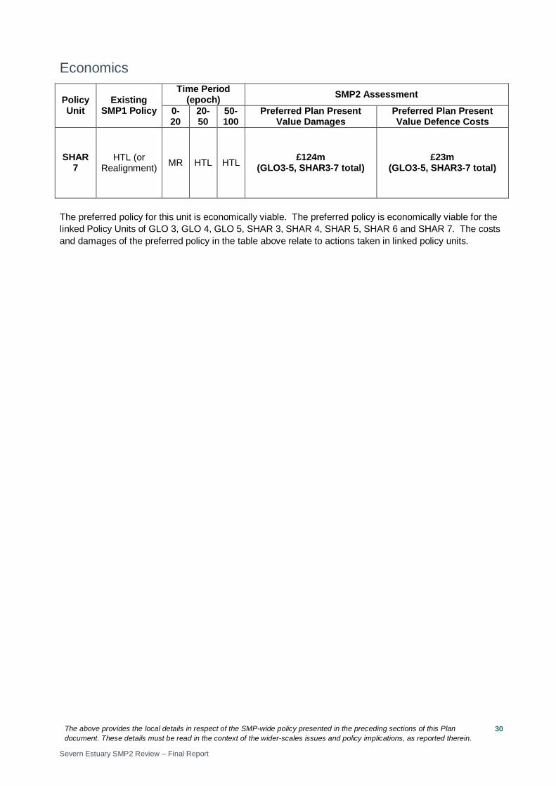
Economics
Policy Unit
Existing SMP1 Policy
Time Period (epoch) SMP2 Assessment
0-20
20-50
50-100
Preferred Plan Present Value Damages
Preferred Plan Present Value Defence Costs
SHAR 7
HTL (or Realignment) MR HTL HTL £124m
(GLO3-5, SHAR3-7 total) £23m
(GLO3-5, SHAR3-7 total)
The preferred policy for this unit is economically viable. The preferred policy is economically viable for the linked Policy Units of GLO 3, GLO 4, GLO 5, SHAR 3, SHAR 4, SHAR 5, SHAR 6 and SHAR 7. The costs and damages of the preferred policy in the table above relate to actions taken in linked policy units.
The above provides the local details in respect of the SMP-wide policy presented in the preceding sections of this Plan document. These details must be read in the context of the wider-scales issues and policy implications, as reported therein.
Severn Estuary SMP2 Review – Final Report
31
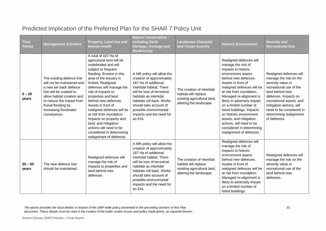
Predicted Implication of the Preferred Plan for the SHAR 7 Policy Unit
Time Period Management Activities Property, Land Use and
Human Health
Nature Conservation – including Earth Heritage, Geology and Biodiversity
Landscape Character and Visual Amenity Historic Environment Amenity and
Recreational Use
0 – 20 years
The existing defence line will not be maintained and a new set back defence line will be created to allow habitat creation and to reduce the impact from fluvial flooding by increasing floodwater conveyance..
A total of 187 Ha of agricultural land will be undefended and will subject to frequent flooding. Erosion in this area of the estuary is limited. Realigned defences will manage the risk of impacts to properties and land behind new defences. Assets in front of realigned defences will be at risk from inundation. Impacts on property and land, and mitigation actions will need to be considered in determining realignment of defences.
A MR policy will allow the creation of approximately 187 Ha of additional intertidal habitat. There will be loss of terrestrial habitats as intertidal habitats roll back. Works should take account of possible environmental impacts and the need for an EIA.
The creation of intertidal habitat will replace existing agricultural land, altering the landscape.
Realigned defences will manage the risk of impacts to historic environment assets behind new defences. Assets in front of realigned defences will be at risk from inundation. Managed re-alignment is likely to adversely impact on a limited number of listed buildings. Impacts on historic environment assets, and mitigation actions, will need to be considered in determining realignment of defences
Realigned defences will manage the risk on the amenity value or recreational use of the land behind new defences. Impacts on recreational assets, and mitigation actions, will need to be considered in determining realignment of defences
20 – 50 years
The new defence line should be maintained.
Realigned defences will manage the risk of impacts to properties and land behind new defences.
A MR policy will allow the creation of approximately 187 Ha of additional intertidal habitat. There will be loss of terrestrial habitats as intertidal habitats roll back. Works should take account of possible environmental impacts and the need for an EIA.
The creation of intertidal habitat will replace existing agricultural land, altering the landscape.
Realigned defences will manage the risk of impacts to historic environment assets behind new defences. Assets in front of realigned defences will be at risk from inundation. Managed re-alignment is likely to adversely impact on a limited number of listed buildings.
Realigned defences will manage the risk on the amenity value or recreational use of the land behind new defences.
The above provides the local details in respect of the SMP-wide policy presented in the preceding sections of this Plan document. These details must be read in the context of the wider-scales issues and policy implications, as reported therein.
Severn Estuary SMP2 Review – Final Report
32
Time Period Management Activities Property, Land Use and
Human Health
Nature Conservation – including Earth Heritage, Geology and Biodiversity
Landscape Character and Visual Amenity Historic Environment Amenity and
Recreational Use
50 – 100 years
The new defence line should be maintained.
Realigned defences will manage the risk of impacts to properties and land behind new defences.
A MR policy will allow the creation of approximately 187 Ha of additional intertidal habitat. There will be loss of terrestrial habitats as intertidal habitats roll back. Works should take account of possible environmental impacts and the need for an EIA.
In the long term sea level rise will result in more frequent flooding of the seaward side of the defence line and creation of intertidal habitat, altering the landscape.
Realigned defences will manage the risk of impacts to historic environment assets behind new defences. Assets in front of realigned defences will be at risk from inundation. Managed re-alignment is likely to adversely impact on a limited number of listed buildings.
Realigned defences will manage the risk on the amenity value or recreational use of the land behind new defences.
The above provides the local details in respect of the SMP-wide policy presented in the preceding sections of this Plan document. These details must be read in the context of the wider-scales issues and policy implications, as reported therein.
Severn Estuary SMP2 Review – Final Report
33
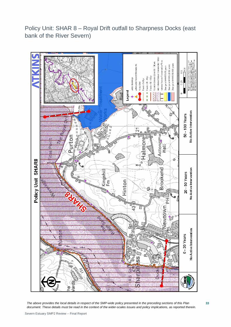
Policy Unit: SHAR 8 – Royal Drift outfall to Sharpness Docks (east bank of the River Severn)
The above provides the local details in respect of the SMP-wide policy presented in the preceding sections of this Plan document. These details must be read in the context of the wider-scales issues and policy implications, as reported therein.
Severn Estuary SMP2 Review – Final Report
34
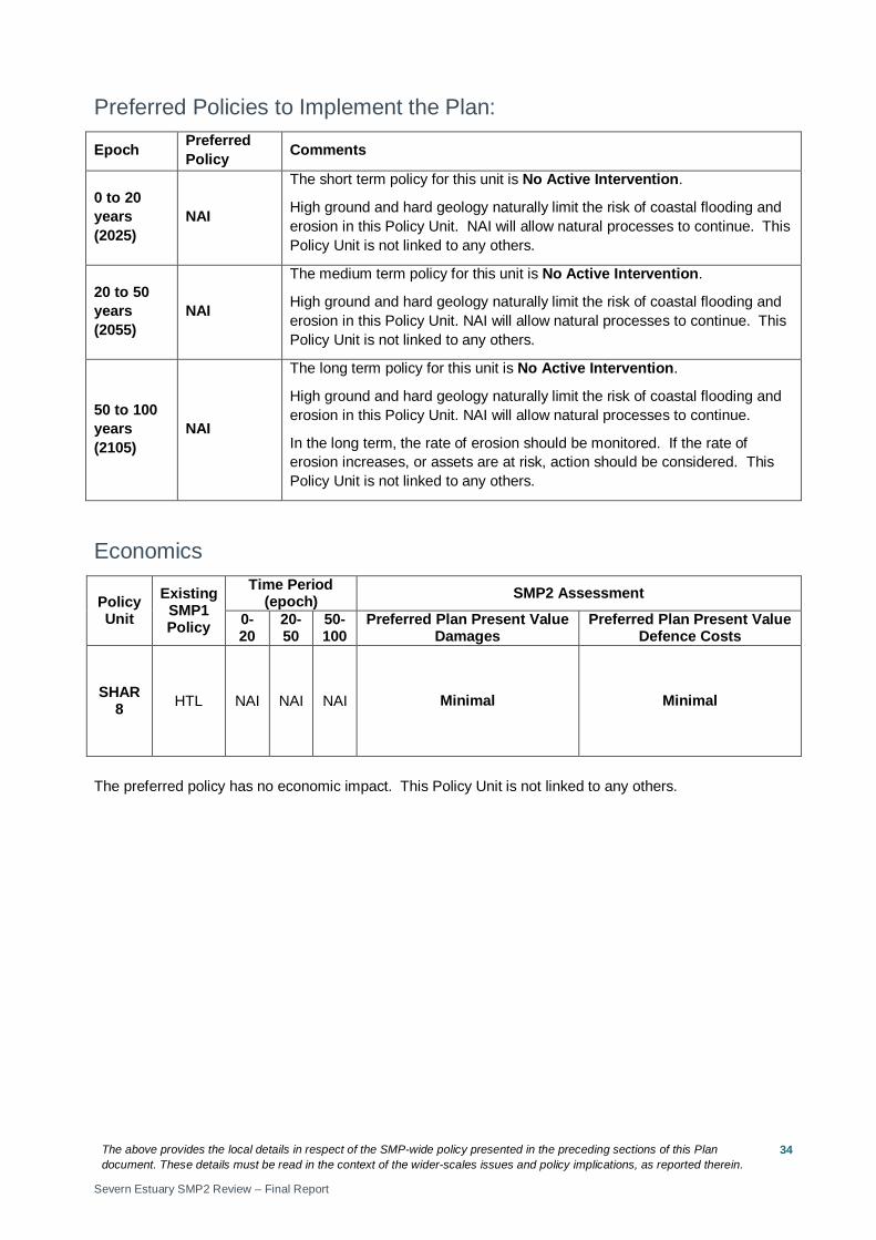
Preferred Policies to Implement the Plan:
Epoch Preferred Policy Comments
0 to 20 years (2025)
NAI
The short term policy for this unit is No Active Intervention.
High ground and hard geology naturally limit the risk of coastal flooding and erosion in this Policy Unit. NAI will allow natural processes to continue. This Policy Unit is not linked to any others.
20 to 50 years (2055)
NAI
The medium term policy for this unit is No Active Intervention.
High ground and hard geology naturally limit the risk of coastal flooding and erosion in this Policy Unit. NAI will allow natural processes to continue. This Policy Unit is not linked to any others.
50 to 100 years (2105)
NAI
The long term policy for this unit is No Active Intervention.
High ground and hard geology naturally limit the risk of coastal flooding and erosion in this Policy Unit. NAI will allow natural processes to continue.
In the long term, the rate of erosion should be monitored. If the rate of erosion increases, or assets are at risk, action should be considered. This Policy Unit is not linked to any others.
Economics
Policy Unit
Existing SMP1 Policy
Time Period (epoch) SMP2 Assessment
0-20
20-50
50-100
Preferred Plan Present Value Damages
Preferred Plan Present Value Defence Costs
SHAR 8 HTL NAI NAI NAI Minimal Minimal
The preferred policy has no economic impact. This Policy Unit is not linked to any others.
The above provides the local details in respect of the SMP-wide policy presented in the preceding sections of this Plan document. These details must be read in the context of the wider-scales issues and policy implications, as reported therein.
Severn Estuary SMP2 Review – Final Report
35
Predicted Implication of the Preferred Plan for the SHAR 8 Policy Unit
Time Period Management Activities Property, Land Use and
Human Health
Nature Conservation – including Earth Heritage, Geology and Biodiversity
Landscape Character and Visual Amenity Historic Environment Amenity and
Recreational Use
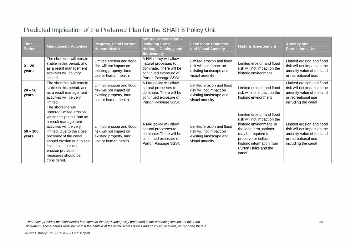
0 – 20 years
The shoreline will remain stable in this period, and as a result management activities will be very limited.
Limited erosion and flood risk will not impact on existing property, land use or human health.
A NAI policy will allow natural processes to dominate. There will be continued exposure of Purton Passage SSSI.
Limited erosion and flood risk will not impact on existing landscape and visual amenity
Limited erosion and flood risk will not impact on the historic environment
Limited erosion and flood risk will not impact on the amenity value of the land or recreational use.
20 – 50 years
The shoreline will remain stable in this period, and as a result management activities will be very limited.
Limited erosion and flood risk will not impact on existing property, land use or human health.
A NAI policy will allow natural processes to dominate. There will be continued exposure of Purton Passage SSSI.
Limited erosion and flood risk will not impact on existing landscape and visual amenity
Limited erosion and flood risk will not impact on the historic environment
Limited erosion and flood risk will not impact on the amenity value of the land or recreational use including the canal
50 – 100 years
The shoreline will undergo limited erosion within this period, and as a result management activities will be very limited. Due to the close proximity of the canal should erosion due to sea level rise increase, erosion protection measures should be considered.
Limited erosion and flood risk will not impact on existing property, land use or human health.
A NAI policy will allow natural processes to dominate. There will be continued exposure of Purton Passage SSSI.
Limited erosion and flood risk will not impact on existing landscape and visual amenity
Limited erosion and flood risk will not impact on the historic environment. In the long term, actions may be required to preserve or collect historic information from Purton Hulks and the canal
Limited erosion and flood risk will not impact on the amenity value of the land or recreational use including the canal