Embed Size (px)
Citation preview

Using fixed & aerial sensorsfor mitigating risks
caused by natural disasters
Zoltan Herczeg
Solutions Consultant, Teamnet

EWS - Early Warning Systems,UAV - Unmanned Aerial Vehicles

Early Warning Systems
Fixed sensors to detect:
• Floods
• Pollution
• Earthquakes

Case study: Earthquake EWS at the
Bulgarian – Romanian border
4

How it works?
5
Romania
BulgariaSeismic sensors
Seismic sensors

Benefits
• Fast alerting allows a 30 to 40 seconds window before the actual occurrence of the earthquake;
• Automatic alerting of local governments and public safety agencies;
• Fast approval process for alerting citizens, including override for unusual events;
• Clear plan definitions for different types of events;
• Customizable plans and alerting schemes;
• Risk maps generation and simulations;
• Easy integration with 112 systems using the same EmerGIS application.
6

Case study: Flood EWS at the
Hungarian – Romanian border
7

How it works?
8
Romania
Ukraine
Hungary
Serbia
Flood sensors

Benefits• Flood prevention by creating risk maps, simulations
and developing countermeasures upfront;
• Reduced impact of floods by assisting decision makers with real-time data and offering a common operational picture;
• Real-time collaboration between authorities, local governments and public safety agencies;
• Improved management of resources to be used during disasters;
• Centralized management of hazardous materials and plans for intervention in case of spilling;
• Proactive intervention and communication plans to follow in case of disasters;
• Faster alerting allows now enough time for evacuation of the population;
• Customizable plans and alerting schemes;
9
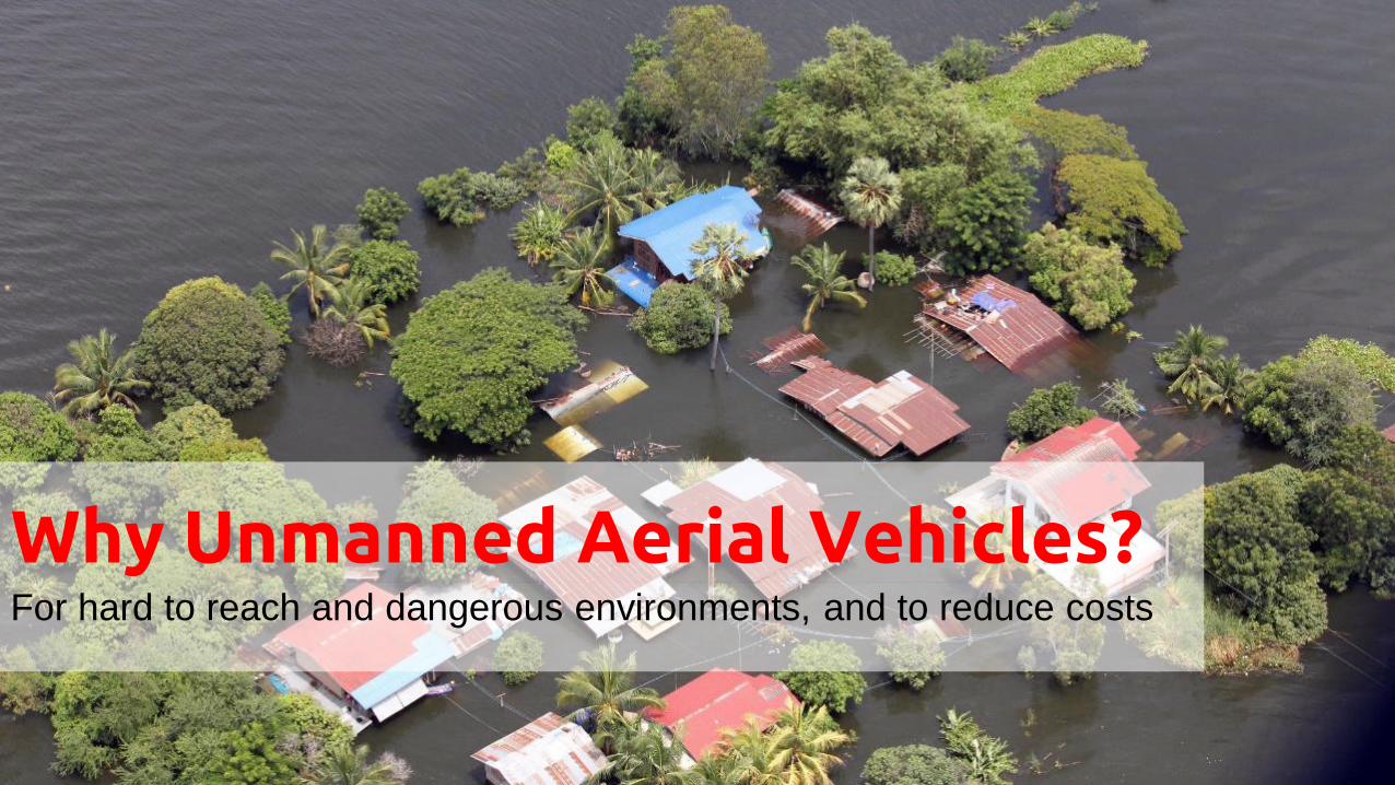
For hard to reach and dangerous environments, and to reduce costs
Why Unmanned Aerial Vehicles?

Manned helicopters and aircrafts
Unmanned multirotor and fixed wing drones
Alternatives

HirrusAuto piloted fixed wingenterprise UAVAir vehicle, ground control station, data link terminal, takeoff, landing
Entire system can be easily carried in a 4x4 vehicle

Hirrus UAV specsWingspan: 3 m
Length: 1 m
Noise: 35 dB
Maximum Take Off Weight
9 kg (“mini” category)
Maximum Speed
120 km/h
Cruise Speed
90 km/h
Service Ceiling
3000 m ASL
Autonomy
3 h
Take off
Launcher
Landing
Parachute
Max. Payload weight:
1 kg
Propulsion: Electrical

• Daylight camera (video);
• Thermal imaging camera (IR, video);
• High definition camera (stills);
Other types:
• Multispectral camera (visible light, IR and more);
• Specialized sensors (e.g. chemical, radiological);
• Drop-off mechanism.
Payloads

GCS – GroundControl Station
• Missions planning and control;
• Changing flight plans during the missions;
• Self test, launch and recovery;
• View mission data (control data, video stream);
• Offline mission replay;
• Relay data to C2 or PSAP;
• Automated flight missions (e.g.: follow target)
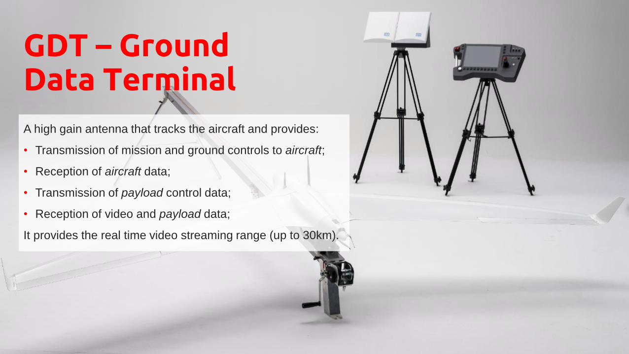
GDT – Ground Data Terminal
A high gain antenna that tracks the aircraft and provides:
• Transmission of mission and ground controls to aircraft;
• Reception of aircraft data;
• Transmission of payload control data;
• Reception of video and payload data;
It provides the real time video streaming range (up to 30km).

Search and rescue, floods, wild fires, border surveillance
Scenarios
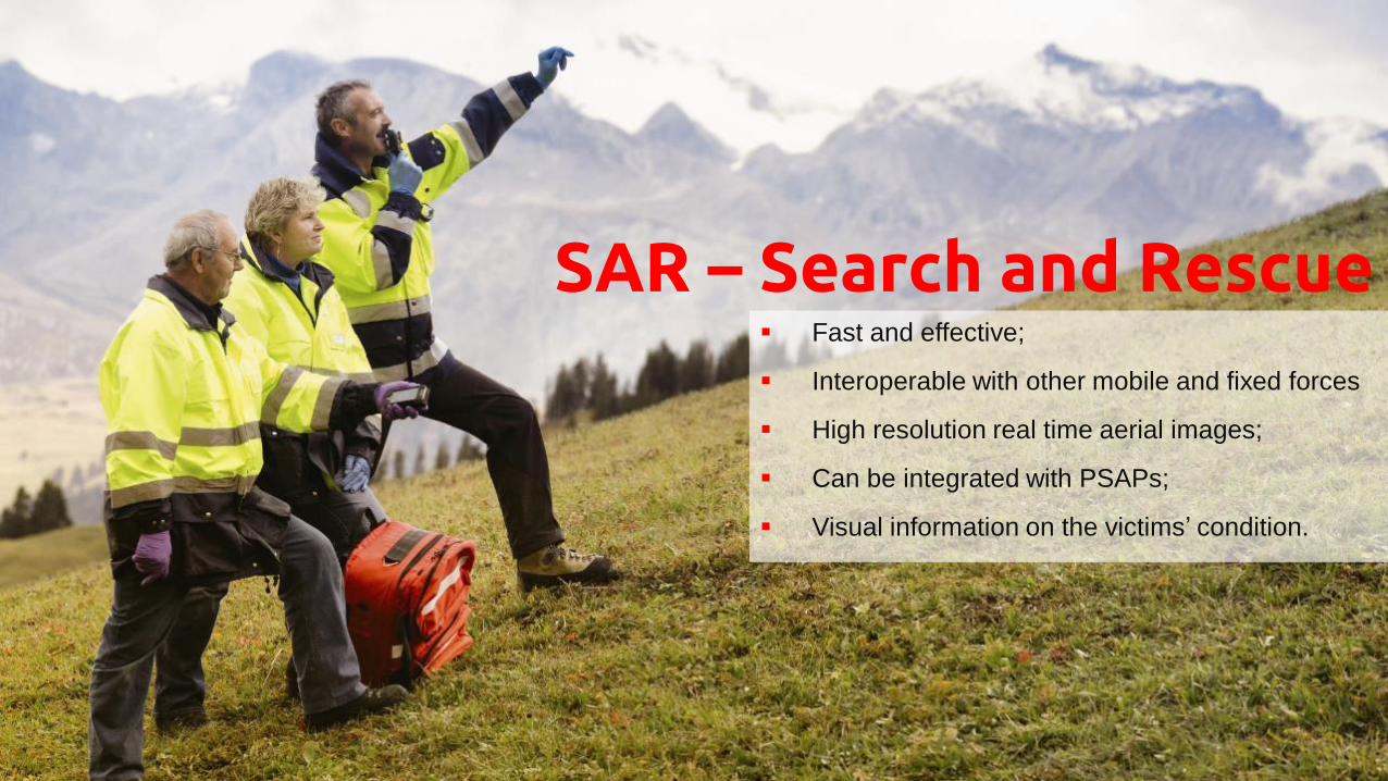
SAR – Search and Rescue Fast and effective;
Interoperable with other mobile and fixed forces
High resolution real time aerial images;
Can be integrated with PSAPs;
Visual information on the victims’ condition.

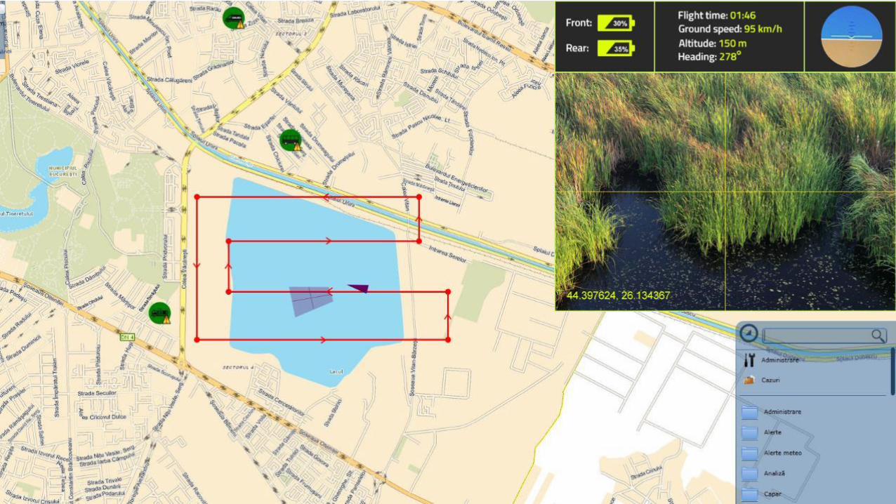
Floods
• Propagation prediction and warning;
• Search and rescue;
• Damage assessment;
• Aid drop-off;
• Can be integrated with PSAPs.
Number of houses affected 234
Number of people affected 512
Maximum water depth 1.32 m
Dykes affected 73 m

Wild fires
• Detection
• Suppression
• Post fire monitoring
• Can be integrated with PSAPs

Border surveillance
• Rescuing refugees;
• Day and night surveillance.
• Can be integrated with PSAPs;

Integrating RPAS in PSAPs

Recommendations

Legal, safety, operational
• Local procedure requirements and smart airspace segregation - the solution for regulatory
framework
• Mission allocations and flight sectors;
• RPAS should be complementary to manned air vehicles;
• Flight missions are being transformed:
• Search => unmanned;
• Rescue => manned;
• Training is needed for RPAS operators (successful missions require hands-on experience);
• Spare parts, maintenance and support;

Key features
Key features:
• Integration with C2 (video and control);
• Video for acting fast, HD images to better see details;
• “Up in the air” time;
• Transmission range;

RPAS – a solution for hard to reach and dangerous
environments, and for reducing costs.
Conclusion


![[10 on Tuesday] 10 Essential Steps for Mitigating Natural Disasters' Damage to Historic Properties](https://img.pdfslide.net/doc/110x75/5476ea5eb4af9f0c1f8b4684/10-on-tuesday-10-essential-steps-for-mitigating-natural-disasters-damage-to-historic-properties.jpg)